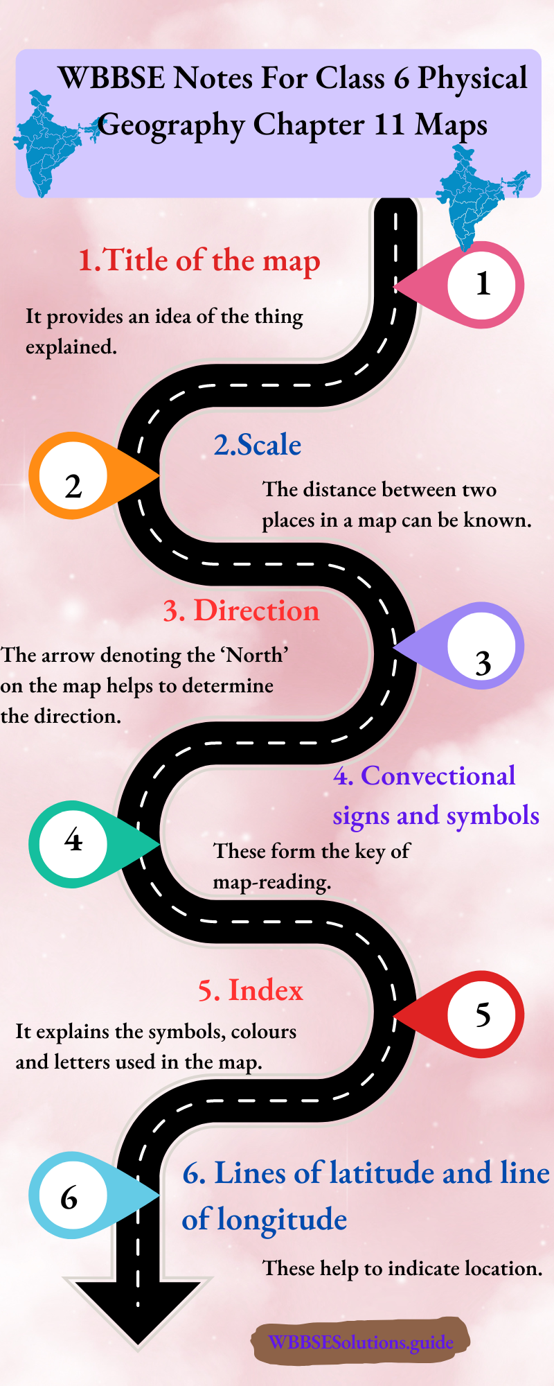
Chapter 1 The Universe And Our Solar System: The Sun, The Stars And The Sky Introduction :
The earth, on which we live, is not alone in space. From our childhood we see the sun shines during the day and at night we see the moon, numerous twinkling stars and other luminous bodies scattered in the sky.
They are called heavenly bodies or celestial bodies. A celestial or heavenly body has been evolved by nature and exists in outer space. Let us examine the groupings of different celestial bodies in space.
Read and Learn More WBBSE Notes For Class 6 Junior School Geography
They may be grouped as follows :
- Galaxies.
- Nebulae.
- Stars.
- Planets.
- Satellites.
- Asteroids or Planetoids.
- Comets and
- Meteors.
Space
Space is an area of unspecified size. It is a continuous unlimited area or expanse which may or may not contain objects etc. Space is not so empty as it was once thought to be.
There are millions of galaxies and other heavenly bodies and each is separated from the others by vast reaches of space.
Sky :
The sky is the region of the atmosphere and outer space seen from the earth.
The Universe
The word ‘universe’ is derived from the Latin ‘Universum’ which means ‘(things) combined into one, whole’. The universe is the whole of creation.
Philosophically, it may be defined as everything that exists or appears to exist, known and unknown, material and non-material. In a more restricted sense, ‘Universe’ refers to all systems of astronomical bodies-Galaxies, Stars, Planets etc.
“WBBSE class 6 physical geography chapter 1 notes”
in the infinite ocean of space. The limitless space of infinite dimensions with its contents is generally referred to as the Universe. The Universe comprises millions and millions of galaxies or star systems.
Yet we do not know about the dimensions of the Universe or the exact number of galaxies. So, our knowledge about the Universe is far from complete.
Black hole :
Black hole is a region of space from which nothing, not even light, can escape. Its force or gravity is much more powerful than any other normal star in the Universe.’

Origin And Expanse Of The Universe :
The most widely accepted theory about the origin of the Universe is the ‘Big Bang’ theory. Many astronomers believe that the Universe began life in a single momentous event.
This was an incredibly hot, dense explosion called the ‘Big Bang’ which took place about 15 billion years ago. During this explosion, all matter, energy, space-and-time itself were created.
In the first few millionths of n second, the particles that makeup atoms, the building blocks of all matter, were formed. It took about 100,000 years for the first atoms, those of the gases hydrogen and helium, to come together.
“the universe and our solar system WBBSE class 6 notes”
By the time, the scary heat of the ‘Big Bang’ had cooled, space has expanded and the gases began to spread out. Gradually, however, gravity drew the gases together leaving vast regions of empty space in between. Our own Earth, along with our Solar system, is a product of a stellar explosion almost five billion years ago.

How Vast Is The Universe ?/Vastness Of The Universe :
The Universe is unimaginably vast. It is billions upon billions of kilometres wide. Distance in the Universe is so great that we have to use a special measure to record them.
This is the light year, or the distance that light, which moves at a speed of about 300,000 kilometres per second, travels in one year (i.e. about 9,460,528,405,000 kilometres).
The nearest star to earth (after the Sun), Proxima Centauri is 4-2 light years away. The most distant objects we know in the Universe are more than 13 billion light years away from Earth.
The Universe is indeed very vast in size. Our Earth may thus be considered to be a sand particle in the desert of the star-studded Universe.
What is Galaxy?
Galaxy:
A galaxy is an archipelago (group of islands) of billion of stars that are held together by the force of gravity. The word ‘galaxy’ itself comes from the Greek word ‘galactic’ which means milk.
This is because galaxies were looked like milky or cloudy areas in the sky before telescopes were powerful. The Universe contains millions of galaxies.
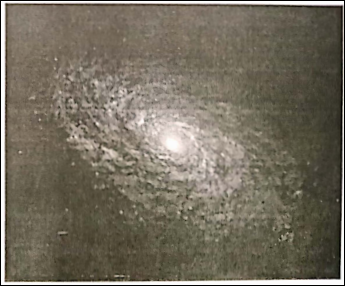
There Are Three Main Types Of Galaxies, According To Thin Shape
- Elliptical, which are oval-shaped,
- Spiral, which have arms spiralling outwards from a central bulge, and
- Irregular which have no obvious shape. The Milky Way is a spiral galaxy.
The Milky Way is only a part of the galaxy. The sun from which we receive light and energy belongs to a galaxy, also known as the ‘Milky Way’, (in India it is known as ‘Akash Ganga’).
“summary of class 6 physical geography chapter 1 WBBSE”
The Milky way is made up of about 100,000 mi sn stars, along with clouds of gas and dust. The Milky way has the shape of a disc. we car. identify the Milky Way on a clear moonless night. It looks like a white belt of shining tiny stars across the sky.
What Is Nebula?
Nebula:
A Nebula is a cloud of dust and gas inside a galaxy from which stars are born. V.ore than one Nebula is called ‘Nebulae’. Nebulae represent the building blocks for stars, galaxies and planets in the Universe.
Nebulae become visible if the gas glows, or if the cloud reflects starlight and obscures the light from more distant objects. Emission nebulae are hot, discrete clouds of primarily ionized hydrogen that glow with their own light.
Reflection nebulae emit a bluish glow by reflecting the scattered light of nearby stars. Absorption nebulae, or dark nebulae, comprise dense clouds of gas and dust. They appear as silhouettes against the light of brighter objects.

The Stars :
A star is a luminous body of hot, glowing gas mostly hydrogen and helium that are born in a Nebula. Stars generate light and release energy from nuclear fusion reactions in their core.
They vary enormously in size, mass and temperature. The colour of a star is determined by its temperature. The hottest star is blue and the coolest is red.
Stars may look like tiny points of light in the night sky but many stars are incredibly big. Betelgeuse, in the constellation of Orion, is 800 times the size of the sun, our local star.
“important questions from the universe and solar system class 6”
Stars seem to twinkle in the sky because we see them through the layers of the earth’s atmosphere. As light passes through these layers, it is distorted so that the amount we actually see changes constantly.
The stars nearest the horizon appear to twinkle the most because the light is passing through a greater depth of atmosphere. Stars do not twinkle when viewed from space, which is why telescopes in space.

Constellation :
Constellation is a group of stars that forms an imaginary pattern representing an object, animal or person as seen from the Earth. Cassiopeia, Orion, Ursa Major, Ursa Minor etc. are a few of the well-known constellations.
Cassiopeia :
‘Cassiopeia’ is named after queen Cassiopeia of Greek mythology. It is seen in the northern sky. Cassiopeia forms an ‘M’/’W’-shape by its five bright stars.

Orion :
‘It looks like a gallant hunter. It is one of the most beautiful of all constellations. In Bengali, it is known as ‘Kalpurush’. It is seen in the southwestern sky.

‘Ursa Sky Major :
Ursa Major is a group of seven bright stars. The meaning of this name is the ‘great bear’. In India, it is known as ‘Saptarshi Mondal’. These stars form a pattern known as the ‘Big-Dipper’ in the U.S.A. and the ‘plough’ in the U.K, These stars are usually seen in the northern sky in most of the northern hemisphere.

Planets :
A planet Is a heavenly body that orbits a star while rotating on us axis. He word ‘planet’ comes from the Greek word ‘planets’. it means ‘wanderer and were so named as they seemed to move about or wander in the sky.
Planet dees not tad-late Its own light, but reflects the light from the star. While stars appear to twinkle, planets shine with a steady light because planets lie at comparatively smaller distances while the planets are rotating their own axis, they also revolve the sun (nearly star).
Characteristics :
- A planet is much smaller in size than a star,
- Planets have no light of their own.
- Planets are illuminated by light from the? star and also reflects the light from the star,
- Planets may be solid or gaseous,
- AH planets do not have satellites,
- Planets revolved around the stars.
| Class 6 History | Class 6 Social Science |
| Class 6 Geography | Class 6 Science |
| Class 6 Maths | Class 6 Science MCQs |
| Class 6 General Science | Class 6 Maths Solutions |
| Class 6 Geography | Class 6 Hindi |
Difference Between Star And Planets :
| Stars | Planets |
| 1. Stars are huge heavenly bodies of hot, glowing gas that are born In nebulae. | 1. Planets are smaller heavenly bodies that are cold and solid. |
| 2. Stars have their own light and heat. | 2. Planets arc lighted and heated by the sun. |
| 3. Stars are very large. | 3. Planets are smaller than stars. |
| 4. Stars are twinkling. | 4. Planets do not twinkle because it just reflects the light received from pi a star. |
| 5. Generally, stars are stations!y, | 5. Planets are moving around the stars. |
| 6. Stars were originated before the origins of planets. | 6. Planets were originated after the origin of the star. |
| 7. A star holds the central position among the other planets. | 7. Planets revolve around a def. nte s’.a in a definite path to; hit) and direction. |
| 8. A star has planets revolving around it | 8. A planet has satellites revolving around it. |
Dwarf Planet:
A dwarf planet is a smaller celestial round object that orbits the sun. Pluto, Ceres, Erls ate examples of dwarf planets
Characteristics :
- It moves around the sun.
- Its gravitational pull is weak
- It has debris within the orbit
- It is small
- It is not a satellite
Difference Between Planets And Dwarf Planets.
| Planets | Dwarf planets |
| 1. A planet is a celestial body which moves around the sun. | 1. A dwarf planet is a smaller celestial round object that orbits the sun |
| 2. It has sufficient mass for its self-gravity to overcome rigid body forces. | 2. Its gravitational pull Is weak. |
| 3. Its orbit is not round. | 3. Its orbit Is nearly round. |
| 4. It has cleared neighbourhoods around its orbit. | 4. It has debris within its orbit |
Satellites
The word satellite means ‘attendant’ or ‘follower’. Satellites are small spherical heavenly bodies that rotate on their axis and revolve around the respective planets. All planets do not have satellites.
“WBBSE class 6 geography chapter 1 key points”
The earth has only one natural satellite. The name of the earth’s satellite is ‘Mono’ Mercury and Venus have no satellites like planets satellites also have no light and heat of their own. Sunrays are reflected from satellites. So they look bright.
Differences between Planets and Satellites :
| Planets | Satellites |
| 1. Planets are much bigger than satellites. | 1. Satellites are much smaller than planets. |
| 2. Planets revolve around the stars. | 2. Satellites revolved around the planets. |
| 3. Planets are far from the stars. | 3. Satellites are closer to the planets than the stars. |
| 4. Life may exist in any planet. Our earth Is the only planet where plants and animals live. | 4. There is no trace of life in satellites. |
Comets :
A comet is a luminous mass of cosmic dust or nebulous matter having an elongated tail and moving in a highly elliptical orbit around the sun.
Comets are such heavenly bodies which of ten exist in the ‘Kuiper Belt’ at the edge of or beyond the solar system. They are different from stars and other heavenly bodies.

Characteristics:
Comets are small bodies with a core of dust and frozen gases.
- They have a head called ‘coma’ and a long tail. Many comets do not have tails. A well-developed comet has a tail that always turns away from the sun. The tails are often bright and millions of km long. The tail is made of glowing gas and dust.
- Most of the time comets remain outside the solar systems and cannot be seen.
- Comets move around the sun in regular orbits and their path is elongated and elliptical.
- Comets take from hundreds to thousands of years to complete one revolution around the sun.
- The comets eventually die.
Halley’s comet discovered in 168z, by Edmund Halley is a periodical comet. It is seen at intervals of 76 years. It was seen in 1910 and 1986. There are many Non¬periodical comets. They are very rare and not sighted at regular intervals.
Meteors/Meteoroids:
While looking at the night sky sometimes one may notice a bright light moving with a considerable velocity which disappears immediately. Some call it a ‘shooting star’, some say ‘a star is falling.
‘ In fact, these are mostly meteors or meteoroids. Meteoroids are small chunks of stone or some of which are fragments of asteroids or comets. If a meteoroid enters the Earth’s atmosphere, from outer space, it is heated by friction and appears as a glowing streak of light called a ‘meteor’.
They are attracted by the Earth’s gravity and rapidly pass near the earth, they are seen as rapidly moving bright objects in the sky lasting for a few seconds. So, they are also called ‘shocking stars’. ‘Meteor showers’ occur when the earth passes through the trail of dust particles left by a comet. Most meteors burn up in the atmosphere.
The few that are large enough to reach the earth’s surface as a large boulders. These are termed as ‘meteorites’. A large, meteor crater, of diameter of 12000 metres is known to exist in Arizona State of the United States.
Meteors are known to have fallen on other planets and satellites also, resulting in the formation of craters.

Asteroids :
Asteroids are small, mostly rocky, irregular-shaped bodies, orbiting the sun. Asteroids range in size from tiny specks to about 1000 kilometres in diameter.
They are sometimes known as ‘minor planets’ or ‘Planetoids’. These are found between the orbits of Mars and Jupiter. Asteroids move around the sun in the same direction as other planets, e.g.-Harmes (32 km of diameter).
There are also some known asteroids Juno (diameter 190 km), Vesta (diameter 390 km) and Pollas (diameter 490 km). The asteroids resemble the planets in all respects except their small and irregular size.
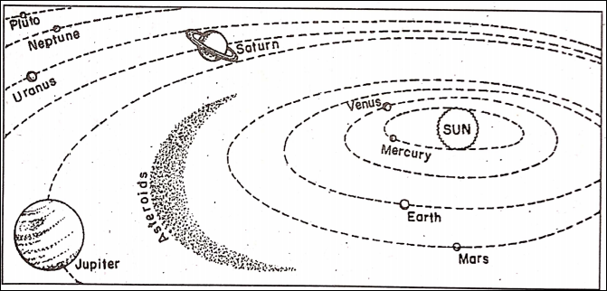
The Solar System
The Solar system consists of the Sun, together with the planets, their moons (natural satellites), comets, asteroids, meteoroids, and a mass of gas and dust that circle around it.
The Latin equivalent of ‘sun’ is ‘sol’; that is why it is called ‘solar system’. If planet Earth is our home, then the solar system is our neighbourhood. The Earth is a member planet of our Solar system and our solar system is a small part of the systems of the stars collectively known as ‘galaxy’.
It is known as a system because all the heavenly bodies of the Solar family are bound by independent relations. The Sun is the nucleus of the Solar system around which other celestial bodies as members of the system revolve along their respective orbits. The Solar system has a diameter of about 11790 million km.
Its planets can be easily grouped into two divisions.
(1) Inner Planets :
These planets (Mercury, Earth, Venus, and Mars) are small in size but have high densities. They are also known as ‘Terrestrial Planets’.
(2) Outer Planets :
These planets (Jupiter, Saturn, Uranus, Neptune) are big in size but have low densities. They are also known as Major planets or Giant planets. It should be noted that the solar family occupies a very small part of the Universe.
How The Solar System Is Formed :
Formation Of Solar System:
Scientists believe that about 4.6 billion years ago there was no sun, no moon and no solar system at all. But there was only clouds of dust and gases in space.
These gases, main hydrogen and fly partly helium together with dust particles in space forming a cosmic cloud. When this cloud is disturbed by different cosmic factors then it is squeezed.
Eventually, it collapsed creating a flat spinning disc of gas and dust. The disc gradually formed a Nebula. French Scientist Laplas thought that parts of a huge Nebula separated and cooled to give birth of these planets.
According to Russian scientist Auto Smith gases and dust particles around the Sun combined to form these planets. According to Friedman of Russia and Mublc (USA), about 15 billion years back by the explosion of a giant heavenly body huge stars were formed which in turn exploded to form small stars and these planets.
Recently British scientist Stephen blockings has also supported this theory.
He Members Of Our Own Solar System Or Solar Family :
The Sun is the head of the solar family and our Earth is the member planet of this family. The members of this family are the Sun, eight planets (including our earth), and their satellites, three dwarf planets and thousands of asteroids, meteors and comets.
The sun holds the members of its family of planets and others near it by the pull of its own gravity. All the planets and asteroids (planetoids) move around the Sun in fixed elliptical paths called Orbits.
99.87% by volume of the total matter of the solar family is connected within the sun.
The Sun :
The Sun is a very ordinary star in the Universe but the head of the solar family. It appears bigger and brighter as it is closer to the earth than all the other stars. The Sun is located at the centre of the solar family and about 15 crore km away from our Earth. But actually, Sun is 13 lakh times bigger than the Earth.
It is a gigantic ball of gases composed mainly of hydrogen and helium. The temperature at the core or centre of the Sun is around 1.4 million°C. Its surface temperature is about 6000°C. From its central core to the surface.
There are four distinctive layers, they are—
- Core of the Sun.
- Photosphere.
- Chromosphere and
- Corona.

1. Core of the Sun
The hottest central part of the Sun is known as the core which is made of hydrogen and helium in a burning state.
2. Photosphere
The visible yellow face of the Sun is called the photosphere or the sphere of light. Here the temperature is about 6000°C. Dark patches called ‘Sunspots’ are sometimes seen in the photosphere.
These are the cooler spots where the temperature is about 4500°C. The rays and heat we get from the sun, radiating from it.
3. Chromosphere
It lies surrounding the photosphere. It is pink in colour. Thousands of big flames are radiating in every second in this part. The flames of the chromosphere are called ‘prominences’.
4 Corona
Behind the chromosphere lies the corona. A bright gaseous belt above the photosphere is known as a corona. It is the uppermost layer of the sun. A regular observation shows that the Sun rotates on its axis.
The time for one complete rotation of the Sun is equal to about 25 days. The Sun also revolves around the centre of the Milky Way (our own galaxy) once in 200 million years. In India, it is known as ‘Akash Ganga’.
Planets Of Our Solar System
There are eight big planets in the solar family. According to distance from the Sun, these are-
- Mercury.
- Venus.
- Earth.
- Mars.
- Jupiter.
- Saturn.
- Uranus and
- Neptune.
There are also three dwarf planets. These are-
- Pluto
- Ceres and
- Eris.
Mercury :
Mercury is the nearest or closest planet to the Sun. God of commerce and also a messenger for other Gods. Mercury was the Roman. Mercury was named after the speedy messenger of the gods because it is seemed to move more quickly than the other known planets.
It is slightly larger than our moon. It has no atmosphere or hydrosphere. It also has no satellite. Mercury’s surface is bare, rocky and covered with craters. So, it looks quite similar to that of our moon. It has great extremes of temperature.

Venus
Venus is a fascinating planet. It is the brightest planet of the Solar system. Often it will be near the moon in the sky, making its identification easy. Venus is named for the Roman goddess of love. It is the only planet in the solar system with a female name. In many ways, Venus is nearly earth’s twin.
Considering the value of Earth as 1, Venus has 0.82 times of mass, 0.95 times the radius and 0.94 times the density of the Earth. Therefore Venus is called ‘Earth’s Sister twin’.
“formation and structure of the universe class 6 notes”
Venus is different from Earth in many respects. Venus rotates from east to west. This means that the Sun would appear to rise in the west and set in the east.
It has a thicker and denser atmosphere than the Earth. Venus is probably the hottest planet of the Solar system. The surface temperature is estimated at about 500°C on the sunlit side.

One of the reasons for the high temperature is that the planet rotates extremely slowly. A second reason is the effect of the thick atmosphere around the planet. So, there is no trace of life on Venus.
Venus is visible in the eastern part of the sky early in the morning, then it is called ‘Morning Star’ and in the evening when it is visible in the western part of the sky after sunset is called ‘Evening Star’.
The Earth
The Earth is the third planet from the Sun and it is the fifth largest planet of the Solar system. The Earth has an atmosphere which is rich in nitrogen and oxygen.
There is an abundance of water on the Earth. No other planet has such a large amount of water. The Earth has optimum conditions for the growth and evolution of various forms of life.
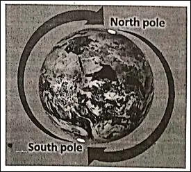
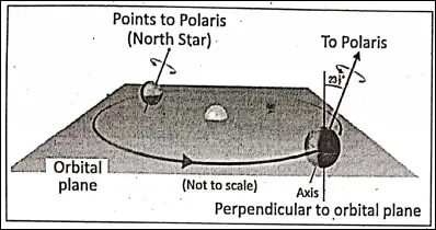
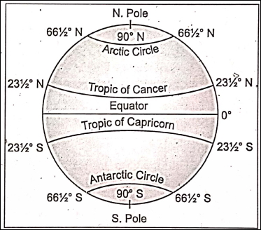
The Earth has two motions—rotation and revolution. It causes day and night and changes of seasons.

The Mars
Mars is fourth in distance from the Sun and seventh in size. In ancient Rome, Mars was initially a god of fertility and agriculture, but later he also became the god of war.
It is called the ‘Red Planet’ as its surface is covered with red sand and boulders. It has dead volcanoes and deep T-shaped valleys where water once flowed freely.
“the solar system and its planets WBBSE class 6”
The planet has white, polar caps of dry ice. It has two sateilites-Phobos and Dimos. No evidence of life has been found on this planet.

The Jupiter
After the Sun, Jupiter is the most dominant body of the Solar system. It is called “King of the Planets.” Jupiter is the largest planet in the Solar system and is big enough to contain more than a thousand Earths (about 1500).
It is made up of very light matter—a mixture of liquid and gaseous forms of hydrogen and helium. Its mass is equal to the mass of 318 piles of earth. Its equatorial diameter is eleven times that of the Earth.
Like the Earth Jupiter also has its own magnetic field. Along with Saturn, Uranus and Neptune, Jupiter is known .as a ‘Gas giant’, because it is mostly made of gas with no solid surface at all.
The colourful patterns of red, brown, yellow and white on Jupiter’s surface are produced by the chemical sulphur and phosphorus in the swirling atmosphere.

The Great Red Spot’, is its most famous feature. Jupiter has a system of rings consisting of dark grains of dust. It has 63 moons or natural satellites, among them four moons are important. They are Ganymede, Callisto, lo and Europa.
The Saturn
Saturn is the second largest planet. Saturn is the .most beautiful planet in the Solar system because it is surrounded by a system of many rings. Three well-defined rings have been identified.
These consist of small particles of matter densely packed to appear like a ring of matter revolving around the planet. Besides, these rings Saturn has also 62 satellites.
Of these satellites ‘Titan7 is the largest. Like Jupiter, Saturn is also made up of hydrogen and helium. So, Saturn . is the lightest planet, and if a large ocean were available, Saturn would float on it.

The Uranus
Uranus is the seventh planet from the Sun and the third largest. It was discovered in 1781 by William Herschel. Uranus is enriched by 11 rings. Uranus is tilted 98° from the vertical. So it is unique among the planets in its axis of rotation lies close to the orbital plane.
Uranus is the most featureless planet to have been closely observed. Its atmosphere contains traces of methane giving the planet a blue-green hue. It has 27 Satellites.

Neptune
Neptune is one of the furthest planets from the Sun. It is a gas giant and is thought to consist of a small rocky core surrounded by a mixture of liquid and gases. The atmosphere contains several prominent cloud features. Triton is the largest Neptunian moon and the coldest object (- 235°C) in the Solar system.
There are five rings encircling the planet. Like Uranus, Neptune also looks green because of methane in its atmosphere.

Pluto :
Earlier, Pluto was considered as the ninth, smallest, coldest and outermost planet in the

Solar System with one named (Charon) and two unnamed satellites. Since 24th August 2006 in the ‘International Astronomical Union’ (IAU) Conference, Pluto was downgraded as ‘Dwarf Planet’.
Dwarf planets are smaller round objects that orbit the Sun. Because their gravitational pull is weak, they have debris within their orbits. They are not however satellites of other planets. Ceres (found in the asteroid belt) and Eris (located in the Kuiper belt) are also dwarf planets.
Journey To Space
From many thousands of years ago humans wished to gather knowledge about the wandered sky where the twinkling stars, the Sun, the Moon and the other heavenly bodies are all together.
With the progress of time, the study of space is carried out by astronomers with telescopes.
Telescope :
The telescope is an optical instrument using lenses or mirrors or both to make distant objects appear nearer and larger.

Space Suit :
A space suit is a specific dress which is used by someone travelling to space wears a dress filled with and designed to keep out radiation in space.
Rocket:
A rocket is a vehicle used for travelling in space because it is able to overcome gravity and shoot up to space.

Spacecraft :
Spacecraft is a vehicle used for travelling in space.
Space Shuttle
Space Shuttle is a rocket for repeated use, especially between the Earth and a space station. A rocket can take us to space but cannot ensure our safe return to earth. For this, we need a space shuttle.
Space Station :
The space station is an artificial satellite used as a base for operations in Space.
Artificlaf satellites
Artificial satellites are man-made assemblages of machines and automated devices that revolve around the earth. Many countries have launched their satellites.
They help in the weather forecast, aviation, navigation, communication and other branches of space research. For example, in 2012 NASA of the United States of America sent the rover ‘Curiosity’ to Mars.

Its main objective was to facilitate research regarding the availability or presence of water, soil, weather and life on Mars. The first artificial satellite to the space is Sputnik-1 (meaning Baby Moon in the Russian Language). It was sent by Russian scientists on October 4, 1957.
The first living being to space:
Lika, the Russian dog was the first living being to venture out to space.
The first Man in space :
Yuri Gagarin was the first man to travel to space. On the 12th of April 1961, spacecraft namely Vostok-I of the Soviet Union with him made its first journey to space. He orbited around the earth and his spacecraft returned safely on the earth after making a complete circle.
The first woman in the space :
The first woman in space was Russian Lt. CoL. Valentina Tereskova. She was sent to the space in Vostok VI on June 16, 1963.
India’s Space Research
It should be noted that India has made a glorious stride over the space research and space journey. India holds the third position in the world in space research activities.
The first space satellite named ‘Aryabhatta’ was launched on 19th April 1975. It was followed by Bhaskar, Rohini-1, Rohini-2, Apple, INSAT, and so on.

Then after a couple of intense movements India’s ‘Lunar Impact’ Probe,’ launched by tricolour. ‘Chandrayan’-l reached on the moon’s surface on 14th November 2008, at 8: 31 pm.
The major activities of ISRO (Indian Space Research Organization) are at present connected on the regular study of the unnamed satellite sent to space namely INSAT, GSAT, SARAL etc. as Geo-Stationary Satellites and Earth Observation Satellites for weather forecasting and other necessary data collection.
“importance of the Sun in our solar system class 6”
Recently India has sent one spacecraft as Mars Orbit Mission.
Chandrayan-2
July 22, 2019, is a historic day for space science and technology in India. India’s space agency or Indian Space Research Organisation (ISRO) on that day (2:43 pm) launched the Chandrayan-2 spacecraft into an orbit around Earth and a 48-day journey towards the lunar south pole, intending to make India the fourth country to reach the Moon.
Chandrayan-2 is intended to be the first aircraft to land near the Moon’s south pole, a region of special interest to lunar scientists. The spacecraft is expected to reach the Moon’s neighbourhood on August 20, 2019.

Notable Indian Astronauts
Rakesh Sharma :

Rakesh Sharma, the first Indian astronaut visited the space in 1984 along with the Russian astronauts. They spent eight days in space in the Soyuz T-ll space station.
Kalpana Chawla
Kalpana Chawla was the first Indian woman in space. She went into space as a mission specialist on the space shuttle Columbia in 1997 and spent about 372 hours in space. Her second space mission was on January 16, 2003.
On February 1, 2003, her space shuttle Columbia met with a disaster during re-entry into the atmosphere of the Earth -and Kalpana Chawla, along with all the seven crew members died.

Sunita Williams
Sunita Williams is an American astronaut of Indian origin. She holds the record for the longest single space flight by women for about 195 days. She is also accredited with a record 50 hours 40 minutes of most space walk time for a woman.

The Moon
The Moon is the only natural satellite of the Earth. It is the nearest heavenly body being only 3,84,000 km from the Earth. It is about 50 times. Smaller than the Earth and is the Only heavenly body that astronauts have set foot on.
The Moon is very tiny compared to the sun, but it looks as big as the Sun is 400 times farther from the Earth and the Moon. The Moon is the brightest object in the night sky. The Moon travels round the Earth once in about 27. days 7 hours and 14 seconds. This is called ‘Lunar Month’.
“characteristics of stars and constellations WBBSE”
The Moon takes roughly the same time to spin around its axis once. Thus the same sHe (near side) of the Moon always faces the Earth. There is no life, no air, no sound and no water on the moon.
The surface of the moon has many dead volcanoes with large craters, numerous hollows created by meteorites and vast dust-covered rocky plains known as ‘Maria’ or seas.
Since the low-lying parts and the hollows remain in shadow, they look like dark patches. The Moon has no atmosphere because its gravity, only one-sixth that of the Earth, is not strong enough to hold down gases.
However, its gravity is strong enough to pull the Earth’s oceans and causes tides. The temperature on the Moon reaches extremes from 100°C on its nearside (Sunlit side) to – 180°C on its far side (dark side).
Phases Of The Moon :
We often see just a part of the Moon which becomes larger or smaller light by night. As the Moon revolves around the Earth, its shape appears to change.

This is because different portions of the lighted face of the Moon can be seen from the Earth at different positions. The changes in the Moon’s appearance from ‘New Moon’ to ‘Full Moon’ and again from Full moon to New moon. Every month the Moon goes through all its phases.
Lunar Eclipse :
An eclipse occurs when the Sun, the Earth and the Moon become collinear i.e., they are in a straight line in the plane of the ecliptic. On certain full Moon, days if the bright Moon gradually becomes darkened either partially or totally, it appears as though some dark shadow falls on its face.

The dark zone of the Earth’s shadow is called Umbra. When the Moon happens to pass through that dark zone, it experiences an eclipse. This is called a ‘Lunar Eclipse’.
Expedition To The Moon
To the early humans as well as scientists the Moon was one of the most fascinating objects. For centuries many facts are known about the Moon.
Space travel and landing on the Moon was a fantastic dream of man for centuries. His dream came true on July 21, 1969, when an American astronaut, Neil Armstrong, placed his foot on the surface of the Moon.
Armstrong and two other Americans, Edwin Aldrin and Michael Collins travelled to the Moon in a spacecraft named Appolo-11. As the craft came near the Moon, it kept on orbiting the Moon while the astronauts prepare to land.

Michael Collins stayed in the spacecraft while the other two entered the lunar module ‘Eagle’. The Craft that was to land on the Moon. When everything was ready, the Eagle separated from the Principal spacecraft and headed towards the Moon to make a soft landing on the Moon’s surface.
“why the sky appears blue class 6 geography”
At last the Eagle was landed safely and Neil Armstrong came out- from the Eagle and stepped down slowly on the surface of the Moon. Then Aldrin followed him.
Thus Neil Armstrong became the first man to walk on the Moon. From the surface of the. Moon, the astronauts looked at the shining Earth in the black lunar sky and took photographs.
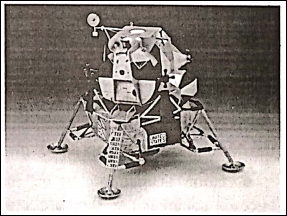
After spending about 24 hours on the Moon, they entered into the Eagle and set off to meet the orbiting space-craft Apolfo- 11 which finally brought them back to the Earth on July 24, 1969.
“difference between planets and stars class 6 WBBSE”
The conquest of the Moon is, indeed, a great achievement and 21st July 1964 is a red letter day in the history of human civilization.
WBBSE Notes for Class 6 Junior School Geography
- Chapter 1 The Universe and Solar System
- Chapter 2 Shape of The Earth: Is The Earth Around?
- Chapter 3 Location of a Place on The Earth’ Surface: Where You Are
- Chapter 4 The Earth’s Motion: The Earth Rotation
- Chapter 5 Water – Land – Air
- Chapter 6 The Ice Capped Continent: Antartica
- Chapter 7 Weather And Climate
- Chapter 8 Air Pollution
- Chapter 9 Noise Pollution
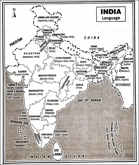
- Chapter 10 India