WBBSE Solutions for Class 9 Geography and Environment Chapter 1 Earth As A Planet

Chapter 1 Earth As A Planet Short Questions With Answers:

You can download WBBSE Class 9 Geography Book Pdf here

Question 1. What is the age of the earth according to a majority of opinion?
Answer. About 4-5 billion years.

Question 2. At what rate moon is moving away from the earth?
Answer. 13 cm per year.

Question 3. What is the distance between the earth and the moon?
Answer. 384400 km.

Read and Learn all WBBSE Solutions for Class 9 Geography and Environment

Question4. What do you mean by centrifugal force?
Answer. A force that pulls the mass away from the centre of a rotating body.

Question 5. Give the formula for calculating the age of the oceans on the basis of their salinity. n Total oceanic salt
Ans.

\( \text { Age of the oceans } \)=\( \frac{\text { Total oceanic salt }}{\text { Annual rate of oceanic salinity }} \)

Question 6. Define star.
Answer. The celestial body which has its own light and heat is termed a star.

Class 9 Geography Solution WBBSE

Question 7. What are referred to as planets?
Answer. The celestial body which does not have its own light and heat but is illuminated by the light of the star is known as a planet.

Question 8. What do you mean by Satellite?
Answer. The celestial body which revolves around its planet is given the name of the satellite.

Class 9 English Bliss Class 9 Life Science
Class 3 English Class 9 Geography 
Class 10 Life Science  Class 9 History 
Class 9 History Class 9 Maths

Question 9. What do you mean by solar system?
Answer. The solar system is the sun family consisting of the sun, the 8 planets, and dwarf planets satellites along with meteors and asteroids.

Question 10. What is the universe?
Answer. Thousands of galaxies form the universe.

WBBSE Solutions for Class 9 Geography and Environment Chapter 1 Earth As A Planet

WBBSE Class 9 Geography Chapter 1 Earth As A Planet Solutions

Question 11. What is the mean distance between the sun and the Earth?
Answer. 14,95,98,000 km. [In terms of light year it is 8.311 minutes per year].

Question 12. What is the age of the earth?
Answer. Age of the Earth: It is generally believed that the Earth is four to five billion years old.

Question 13. What is the position of the Earth according to the distance from the Sun?
Answer. Third.

Question 14. What percentage of Earth’s surface is covered with water?
Answer. 70.9%

Question 15. Name the nearest planet to the Sun.
Answer: Mercury.

Question 16. Name the closest planet to the Earth.
Answer: Venus.

Question 17. State the position of the Earth in terms of the size of the planets.
Answer: Fifth.

Question 18. Name the brightest planet in the solar system.
Answer: Venus.

Question 19. Which planet is called Morning Star or Evening Star?
Answer: Venus.

Question 20. What is the weight of the Earth?
Answer: 6000 billion tonnes.

Question 21. What is the exact diameter of the Earth at the Equator?
Answer: 12757 km.

Question 22. What is the exact diameter of the Earth at the Poles?
Answer: 12714 km.

Question 23. What is the average radius of the Earth?
Answer: 6400 km (approx.)

Question 24. What is the circumference of the Earth around the Equator?
Answer: 40076 km.

Question 25. What is the circumference of the Earth around the Poles?
Answer: 40,000 km.

Question 26. What is the difference between Equatorial diameter and Polar diameter?
Answer: 43 km.

Question 27. What is the average distance between Earth and the sun?
Answer: 150 million km.

Question 28. Who calculated the circumference of the Earth earliest?
Answer: Eratosthenes. (200 B.C.)

Question 29. What is the circumference of the Earth according to Eratosthenes?
Answer: 43,000 km.

Earth As A Planet Class 9 WBBSE Question Answers

Question 30. What is the total surface area of Earth?
Answer: 510 million sq. km.

Class 9 Geography Solution WBBSE

Question 31. What is the time taken by the Sunlight to reach the Earth?
Answer: 8.2 minutes.

Question 32. Name the satellite of the Earth.
Answer: Moon.

Question 33. Name the biggest planet in the solar system.
Answer: Jupiter.

Question 34. How many times the Sun is bigger than the Earth?
Answer: 13 lakh times.

Question 35. What is the mass of the Earth?
Answer: 6.5 x 1027 tonnes.

Question 36. Who first declared that the Earth is round?
Answer: Aristotle.

Question 37. What is the age of the earth according to majority opinion?
Answer: About 4-5 billion years.

Question 38. At what rate moon is moving away from the earth?
Answer: 13 cm per year.

Question 39. What is the age of the oceans according to John Joly?
Answer: 80 million years.

Question 40. Name two minerals which contain the maximum amount of radioactive elements.
Answer: Uranium and Thorium.

Question 41. What is angular velocity?
Answer: Angular velocity is the angle moved by a rotating body per unit of time at a point on the axis of rotation.

Question 42. Define angular momentum.
Answer: Angular momentum is the product of mass, angular velocity and square of the radius of the rotating body.

Question 43. What is meant by proto-sun?
Answer: Our original sun has been given the name of proto-sun by Chamberlin and Moulton.

Question 44. What must be the location of the stars moving across the sky in a circle directly overhead?
Answer: The location must be at the North or South Pole.

Question 45. Who is a selenographer?
Answer: A selenographer studies the geography of the moon.

Chapter 1 Earth As A Planet True Or False Type

Question 1. The moon has no clouds.
Answer: True

Question 2. The moon has gravitational attraction.
Answer: True

Question 3. The Radius of the earth was first measured by Eratosthenes.
Answer: True

Question 4. Mercury is the farthest planet.
Answer: False

Question 5. The polar diameter of the earth is 12,714 Km.
Answer: True

Question 6. Jupiter has a ring around it.
Answer: False

Question 7. The moon has no rotation.
Answer: True

WBBSE Class 9 Geography Chapter 1 Solved Exercises

Question 8. Jupiter is an outer planet.
Answer: True

Class 9 Geography Solution WBBSE

Question 9. Pluto is the farthest dwarf planet.
Answer: True

Question 10. Uranus has a ring around it.
Answer: False

Question 11. Jupiter is the most beautiful planet. 
Answer: False

Question 12. Mercury has the shortest length of the year.
Answer: True

Question 13. The earth is the fifth largest planet in the Solar System.
Answer: True

Question 14. The average radius of the earth is 6000 kilometres.
Answer: False

Question 15. The average distance of the earth from the sun is about 150 million km.
Answer: True

Question 16. The earth is of an oblate spheroid.
Answer: True

Question 17. The difference between the equatorial diameter and the polar diameter is 60 km.
Answer: False

Question 18. Venus is also known as the “Earth twin”
Answer: True

Question 19. For practical purposes, Earth is considered to be spherical
Answer: True

Question 20. Mercury is the hottest planet
Answer: Flash

Question 21. Geoid means” flattened at the poles”.
Answer: False

Chapter 1 Earth As A Planet Fill In The Blanks

Question 1. Distance between the earth and the moon is______.
Answer: 384400 km.

Question 2. Mercury takes days to move around the sun______.
Answer: 88 days.

Question 3. The smallest planet is_______.
Answer: Mercury.

Question 4. The speed of light is miles per second_______.
Answer: i86,ooo

Question 5. is the largest planet______.
Answer: Jupiter.

Question6. The exact shape of the earth is called_______.
Answer: Geoid.

Question 7. The equatorial diameter of the earth is______.
Answer: 12,757 km.

Question 8. The earth is a_________.
Answer: Geoid.

Question 9. The polar diameter of the earth is______.
Answer: 12714 km.

Class 9 Geography Earth As A Planet WBBSE Notes

Question 10. The equatorial circumference of the earth is______.
Answer: 40076 km.

Question 11. The sun is times larger than the earth_____.
Answer: 13 lakhs times.

Question 12. Mercury is a planet_______.
Answer: Inner.

Chapter 1 Earth As A Planet 2 Marks Questions And Answer

Question 1. Why Earth is called ‘Blue Planet’?
Answer: The Earth is called a blue planet because of the colours of the seas and oceans. From space, the earth is seen as blue and that is why it is called Blue Planet.

Question 2. What do you mean by the term “The Earth as a Planet”?
Answer:

The Earth as a Planet

The earth, as a planet, is a member of our social family amongst the 8 planets, it is one of them. As a planet, it has life on it.

Question 3. What is the Milky Way?
Answer:

Milky way

The galaxy of which our sun is a member appears in the sky as the Milky Way. The Milky Way is only a small part of our Galaxy.

Question 4. What is the length of the elliptical path of the Earth?
Answer:

Length of the elliptical path of the Earth

96 crore km.

Question5. What is the difference between a planet and a satellite?
Answer:

The difference between a planet and a satellite

A planet is a heavenly body which revolves around the sun in its fixed orbit but a satellite is a body which revolves around the planet.

Question6. What is Sun’s Ecliptic?
Answer:

Sun’s Ecliptic

Due to the Earth’s revolution the apparent annual movement of the sun’s rays varies between 23(½)° North & 23(½)° South is called the Sun’s Ecliptic.

Question7. State the status of Pluto in the solar system. 
Answer:

Status of Pluto in the solar system

Pluto is nowadays not considered a planet of the solar system. It has been given a special status of a ‘dwarf planet’.

Question 8. Why weight in polar regions are more compared to equatorial regions?
Answer: Compared to equatorial regions, polar regions are nearer to the earth’s centre. So, the gravitational pull is more. The weight of any object taken in the equatorial region, the same object will weigh more in the polar region because of the greater gravitational pull.

Question 9. What does Thales & Anaximander believe regarding the shape of the Earth?
Answer: Thales (550 BC) thought the earth floated in the water like a log. It has been argued, however, that Thales actually believe in a round earth. Anaximander (550 BC) believed that the earth was a short cylinder with a flat, circular top that remained stable because it was the same distance from all things.

Question 10. Discuss how seeing from a ship proves that the Earth is round.
Answer: An observer watching through a telescope the approach of a ship seas first the smoke then the funnels, and then the hull. If the earth were flat we would see the whole of the ship at one time. This proves the rounded shape of the earth.

Question 11. What does the word Geoid mean?
Answer:

Geoid

The word ‘geoid’ means ‘earth-like form’ or ‘Earth – Shaped’.Scientists have given this name to +he shape of the Earth.

WBBSE Solutions For Class 9 Geography Chapter 1

Question 12. What is the rob of Earth’s atmosphere?
Answer:

Rob of Earth’s atmosphere

(1) Atmosphere around the earth prevents all heat from the Sun from reaching the earth during the day, keeping temperatures relatively cool.

(2) At night it acts like a blanket by preventing all the heat from escaping, thus keeping the temperature warm at night.

Question 13. Measure the area of the earth. no 291601

Answer:. Measurement of area of the earth:

Formula for measuring the area of the earth is 4πr²

∴[ Here π = 3.142857, r = 6,379 km or 3,962 miles]
∴4 x 3.142857 x (6,379)2 1369 = 4 x 3.142857 x 40691641 = 511,552,035 sq. km.

Geography Class 9 West Bengal Board

Question 14. Discuss in brief Earth’s unique position in the solar system.
Answer:

Earth’s unique position in the solar system

Earth is in the third position from the Sun and is the largest terrestrial planet. It is the fifth largest planet in terms of size and mass but is the dense planet (5,513 Kg/m3) among all the planets.

Earth is so positioned in the Solar System that it remains protected from asteroids and meteoroids. It is special and unique in one sense that it is the only planet known to foster life in the whole Solar System.

Question15. What do you mean by Terrestrial Planet?
Answer:

Terrestrial Planet:

A terrestrial planet is a planet that is composed primarily of silicate rocks or metals,

Example: Mercury, Venus, Earth and Mars.

Question16. Which planet is known as Earth Twin & why?
Answer: Venus is the only planet in the solar system to spin in the opposite direction of its orbit. It is like Earth in size and mass and hence also known as the “Earth twin”.

Question17. What was the defect in the calculation of the circumference of the Earth by Eratosthenes?
Answer:

Two defects in the method of Calculation:

Eratosthenes was not fully right although his method of calculation of the circumference of the earth was quite good and educative. Eratosthenes measured the distance in Stades, his result for. the circumference being 2,52,000 States.

He could not calculate it accurately at first because Alexandria lies well to the west of the meridian through Syene, while Syene itself is several kilometres north of the tropic of cancer where the sun shines vertically on June 21.

Question18. State two uses of GPS.
Answer:

Uses of GPS

(1) GPS is essential for the modern defence system.
(2) It may be used to identify or define the geographical coordinates associated with satellite imagery.

Question19. Why is Venus a brighter object in the sky than Mars?
Answer: Venus is closer to the sun than Mars and hence receives more sunlight to reflect. It is larger than Mars, so the reflecting surface is greater in area. Venus is a better reflector of sunlight than the cloudless Martian surface. As a result of all these factors, Venus is the brightest object in the sky after the sun and the moon.

Question 20. Why is the average temperature on Mars lower than that on earth? Why is there a great variation in Martian temperatures?
Answer: Being \(1 \frac{1}{2}\) time farther from the sun than the earth, Mars receives considerably less solar energy per metre square than we do. Mars has an extremely thin atmosphere. So little of the heat is retained by the atmospheric blanket of Mars after nightfall. Daytime temperatures at the equator on Mars rise to 20°C but at night drop to – 70°C.

Question 21. Explain why the moon has only one day in a year.
Answer: The moon turns, i.e., rotates only once during one revolution around the earth that is the time of the moon’s rotation and revolution is the same (27— days). That is why the moon has only one ‘day’ in a ‘year’. 1 day for the moon means almost 2 weeks of sunshine (daytime) and 2 weeks of darkness (nighttime). With each new moon, the moon begins its day as well as a new year. So, 1 moon year = time interval between two new moons.

Geography Class 9 West Bengal Board

Question22. Why do not lunar eclipses occur every fortnight?
Answer: An eclipse occurs when the sun, the earth, and the moon become collinear i.e., they are in a straight line in the plane of the ecliptic. However, a lunar, eclipse does not occur on every full moon, because the moon’s orbit is inclined at an angle of 5°9′ to the earth’s orbital plane of the escape entering into the umbra. Thus of the occurrence of an ecliptic, it will be a lunar eclipse, the moon must be very close to the plane of the ecliptic on a full moon day.

Question23. Compare the size of the moon with that of the sun and the earth.
Answer: The diameter of the earth is\(\frac{1}{100}\)  that of the sun. The diameter of the moon is\( \frac{1}{401}\) that of the sun. The sun’s diameter is 1,392.00 km. It would take 49 spheres like the moon to fill the volume occupied by the earth. The moon’s surface is not very large i.e. 36 million sq km even smaller than two America.

Question24. Why is the sky blue? How does the sky appear to an astronaut the earth’s atmosphere during the day, and during the night?
Answer: The blue colour of the sky is due to the scattering of the sun’s light by molecules and dust particles in the atmosphere. Blue light is scattered more effectively than red; hence the sky, which we see only by scattered light, has an excess of blue. Above the atmosphere, the sky appears black, and the stars are visible to astronauts all the time.

Question25. Why do you think stars twinkle when seen from the ground but not when seen by astronauts in space vehicles?
Answer: Irregularities in the atmosphere cause the light from a star to be randomly deviated to some extent by refraction. These deviations are perceived as twinklings; they are not apparent to an observer of the atmosphere.

Class 9 WBBSE Geography Chapter 1 Important Questions

Question26. How is it possible to distinguish the planets from the stars
(1) By observations with the naked eye?
(2) By observations with a telescope?
Answer:
(1) When viewed over a period of time a planet will be seen to change its position in the sky relative to the stars.
(2)Seen through a telescope, the planets appear as disks whereas the stars, which are much farther away, appear as point of light.

Question27. List the planets in order of their size.
Answer:

(1) Jupiter
(2) Saturn
(3) Neptune
(4) Uranus
(5) Earth
(6) Venus
(7) Mars
(8) Mercury.

Question28. List the planets in order of their increasing distance from the sun.
Answer:

(1) Mercury
(2) Venus
(3) Earth
(4) Mars
(5) Jupiter
(6) Saturn
(7) Uranus
(8) Neptune and
(9) Pluto
(10) Vulcan.(the last two are dwarf planets).

Question29. What is Syzygy?
Answer:

Syzygy

Syzygy means three bodies in a line. This occurs at the time of the new moon or full moon when the sun and the moon are lined up with the earth.

Question30. When was the first artificial earth satellite launched into space successfully? What was the name of the satellite?
Answer: October 4, 1957, Sputnik 1.

Chapter 1 Earth As A Planet 2 Marks Questions And Answers (Short Notes)

Question l. The Solar System.
Answer:

Solar System

The night sky seen from all parts of the earth reveals a number of twinkling stars, the milky way, other star-like bodies called planets and different phases of the moon on different days. The earth, all the major eight planets 32 satellites and some 1700 minor planets or asteroids are members of the sun’s family or the solar system.

Geography Class 9 West Bengal Board

Question 2. Asteroids.
Answer:

Asteroids

It is commonly believed that they are fragments of some planet which had its orbit between those of Mars and Jupiter and which disintegrated for reasons which are not yet found. The first asteroid was observed by Guiseppe Piazzi in 1801.

Question 3. View of the earth from space.
Answer:

View of the earth from space

The photography of the earth taken from space shows the earth’s spherical body. As viewed from space, the earth appears like a large globe covered with clouds. Through the gaps in the cloud, the earth’s surface is seen: the polar ice-caps appear brilliant white, the deserts yellowish or red, the forested part dark blue or blue-green, grasslands or cultivated regions generally dull yellow and the oceans appear dark blue except the brilliant patches of reflection of sunlight.

Nearly one-third of the earth’s surface is covered by ocean water and it looks blue. For its blue appearance in space, the earth is called “a Blue Planet”.

Earth As A Planet Class 9 WBBSE Short And Long Answers

Question 4. GPS?
Answer:

GPS

GPS or Global Positioning System is a modern measure to determine the latitude or longitude of a place on the earth. The system is functioned by artificial satellites. The Global positioning system is a space-based satellite navigation system that provides location and time information in all weather conditions, anywhere on or near the earth where there is an unobstructed line of sight to four or more GPS satellites.

Chapter 1 Earth As A Plane 3 Marks Questions And Answers

Question l. Why earth is called GEOID?
Answer:

A term sometimes used to signify the shape of the Earth; the later is often taken to be oblate spheroid, but in view of certain variations, the term GEOID, which simply means earth-shaped body, has been introduced.

The surface of the earth is not smooth and even, but broken up by high mountains and deep seas. It is said that the highest point of the earth’s surface stands at 8,898m. above sea level and the lowest point is at 11,033m below sea level. So the earth’s shape can not be accurately described through any geometrical figure. So the earth is referred to as a GEOID. [It is always written in capital letters]

Question 2. Give a description of the size of the earth & its comparison with different other planets with respect to size.
Answer. Our Earth is in the third position from the Sun among the eight planets that orbit the Sun. It is the fifth largest planet in respect of its size or relative bigness when compared to other planets. The size of a planet is determined by its diameter. If we consider the chart given below we can compare the relative size of our Earth with the other planets :
Table showing diameters of the planets of the Solar System

Earth as a Plant planets of the solar system


WBBSE Solutions for Class 9 Geography and Environment Chapter 1 Earth As A Planet Planets Of The Solar System

Earth is the fifth largest in size after the giant planets Jupiter, Saturn, Uranus and Neptune.

If we take the size of Earth as 1, then Jupiter is about 11.209 times bigger than our Earth having a diameter of 1,42,800 Km as compared to 12,757 Km of our Earth. Saturn, Uranus and Neptune follow Jupiter in order of size but all three are bigger than the earth by 9.44, 4.007 and 3.883 times respectively. The diameter of Saturn is 1,20,000 Km, that of Uranus is 51,118 Km and Neptune is 49,528 Km.

Among the smaller planets close to the Sun, called terrestrial planets, our Earth is the largest. The other planets are Mercury, Venus and Mars. The planet Venus is sometimes called the Earth’s twin as it closely follows the Earth in size.

Geography Class 9 West Bengal Board

Our Earth is about 1/0.949 times bigger than Venus whose diameter is 12,014Km. Mars is slightly more than half the size of the Earth. It has a diameter of 6,787 Km. Mercury, the smallest among all the planets of the solar system has a
diameter of 4,578 Km. The Earth is about 1/0.382 times bigger than Mercury.

Question 3. Given an account of the Bedford-level experiment.
Answer.

Bedford level experiment:

An experiment carried out by Dr Wallace in Bedford canal, Norfolk, England during the nineteenth century gave us convincing proof of the Earth’s curvature. A set of three identical poles of equal heights were fixed a mile apart above the water level along a straight stretch of this canal.

When observed carefully through a telescope it was noticed that the middle pole was about 8 inches higher than the other two poles when observed from either end because of the curvature of the Earth.

WBBSE Solutions for Class 9 Geography and Environment Chapter 1 Earth As A Planet Bedford Level Experiment


Question 4. Discuss how the position of the North Star shows the shape of the Earth.
Answer.

Position of the North Star :
Different stars appear to change or shift their position in the sky with the change in the observer’s position on the Earth’s surface. An observer at the North Pole (90° N) always finds the North Star (Pole star) vertically overhead. As he proceeds southwards, say at 45° North latitude, he finds the North Star midway between the zenith and the horizon. If he moves further south towards the equator (0°), he would observe the North Star at the horizon. The North Star, therefore, appears to shift its position following the arc of a circle.

Question 5. Discuss what aerial photos & artificial satellites reveal regarding the shape of the Earth.
Answer.

Aerial Photographs :

The most clinching evidence of the spherical shape of the earth is obtained from photographs taken from space. Pictures taken by satellites show the spherical shape of the earth. The astronauts from the moon have taken pictures of the earth showing its spherical shape.

Artificial Satellites :

Artificial Satellites and many space probes are put in orbit on the assumption that the earth is spherical. The calculations have proved correct and the space probes of other planets of the solar system have provided valuable data.

Question 6. Determine the diameter & radius of the earth.
Answer.

Determine of diameter and Radius of the earth :

We know the formula of the circumference of the spherical earth is 2πr.

Here π=\(\frac{22}{7}\)  3.142857;
r = radius of the earth.
We know the length of the earth’s circumference = 24,902 miles.

∴2πR = 2 x 3 142857 x r.
∴2 x 3 142857 x r = 24, 902 mile (equation)

r= \(\frac{24,902}{2 \times 3 \cdot 142857}\)

r = 3,961.68 miles

∴ Earth’s radius = 3-962 mile.
∴ Diameter of the earth = 3-962 x 2 = 7,924 mile or 12,758 km.

WBBSE Class 9 Geography And Environment Chapter 1 Summary

Question7. What is the importance of the spherical shape of the Earth?
Answer.

Importance of the spherical shape of the Earth

(1) We calculate time by a system based on the earth as a sphere.
(2)We determine the location of a place on the earth by means of a grid based on the shape of the globe.
(3)Our sense of direction is also based on the earth’s spherical shape.
(4) Differences in temperature from place to place and currents in the oceans and atmosphere are related to the earth’s sphericity.

Class 9 WBBSE Geography Question Answer

Question 8. Explain the concept of the geoid.
Answer.

The concept of the geoid

We learned that the Earth is not a perfect sphere but an oblate spheroid or an oblate ellipsoid. Recent observations and close examination of the Earth’s surface show certain unexplained anomalies. The shape of an oblate spheroid has variations. Therefore the Earth has an undulating or irregular surface.

This irregular surface does not resemble the geometric ellipsoid shape or any known shape. It is absolutely Earth’s own shape and matches with the term Geoid, meaning ‘Earth-shaped’. The geoid is the shape that the surface of the ocean would take under the influence of Earth’s gravitation and rotation alone.

The surface is extended through the continents. All points on the geoid have the same gravitational potential and the force of gravity acts everywhere perpen- DiCarlo the geoid. This means that the plumb line always points perpendicular and the water level is parallel to the geoid.

So, a geoid is the equipotential surface of the Earth’s gravity field. The gravitational field of the Earth is neither perfect nor uniform. The strength of gravity would not be the same everywhere^ because density and mass vary all through the Earth.

This is due to magma distributions, mountain ranges (Mount Everest 8,848 m), deep sea trenches (Mariana trench 10,924 m below sea level) and so on. So, it is important to note that geoid depends on gravitational measurements and not on Earth’s surface (topographic features).

Thus the geoid is defined as an imaginary surface that coincides with the mean sea level in the ocean and its extension through the continents. It is also defined as the surface of the Earth’s gravity field.

The shape so formed is not a flattened sphere but slightly like a pear. This shape is determined by the combination of survey techniques and mathematical analysis known as geodesy.

Question 9. What is a solar eclipse? What are the ‘nodes of the moon’? What are Rahu and Ketu ?
Answer.

Solar eclipse:

As the moon goes around the earth, once each month, it usually passes above or below the sun. We do not see it in the bright daytime sky, but on occasions when the moon passes directly between the sun and the earth, it hides the sun. This is called an eclipse of the sun or solar eclipse.

To hide the sun, the orbiting moon has to cut the ecliptic at two points which are called the moon’s nodes. Rahu and Ketu are the Indian names for these nodes of the moon. Rahu is the ascending node and Ketu is the descending node.

Class 9 WBBSE Geography Question Answer Chapter 1 Earth As A Planet 5 Marks Questions And Answers

Question l. How is the earth called a living planet?
Answer.

Earth – A Living Planet :

In the endless expanse of the universe, the earth is like an insignificant tiny speck. Despite its insignificant size, it is a unique planet not only in the Solar System, but also in the whole universe. Life exists only on it. Animals, plants, micro-organisms and numerous other living beings live on it. The following factors have made life possible on our earth.

(1) The distance of the earth from the sun :
Mercury and Venus are very close to the sun. Therefore, they are very hot, even lead can melt there. On the other hand, there are other planets which are too far from the sun. Hence, they are very cold and even liquids and gases are in a frozen state there. But our earth is at an optimum distance from the sun. So, the earth has an average temperature of 15°C. The range of temperature varies so much that water is found in solid, liquid and gaseous states on our earth. Water is a prerequisite for all forms of life. Life originated and developed in the water then it spread to land. Therefore, plants grow and animals live here.

(2)The existence of three realms on the earth :
The earth is the only known planet in the universe where the atmosphere, hydrosphere and lithosphere exist. Mercury, Venus and Mars have lithosphere and atmosphere; they do not have hydrosphere. Jupiter and Saturn are gaseous planets, which do not have either a lithosphere or hydrosphere. Hence, there is no life on these planets.

(3)The right mixture of gases in the Earth’s atmosphere :
Earth’s atmosphere has an ideal mixture of nitrogen, oxygen-carbon dioxide and ozone. Non-availability of oxygen to our body, even for a fraction of a second, makes us restless. The atmospheres of Venus and Mars mainly consist of carbon-di-oxide. Hydrogen and helium, dominate the atmosphere of Jupiter.

(4)The presence of the ozone layer in the atmosphere of the earth :
The ozone layer absorbs a large proportion of the sun’s ultraviolet radiation. Without this absorption, the earth would be subjected to a degree of ultraviolet radiation which is injurious to plants and animals.

Class 9 WBBSE Geography Question Answer

(5)The ideal duration of day and night :
The average duration of day and night on the earth is of 12 hours each. A single night on Mercury is as long as 30 earth nights. On Venus, the night is still longer. It is about 122 earth nights long. In contrast on Jupiter and Saturn, the duration of a night is only five hours each.

Class 9 Geography Earth As A Planet WBBSE MCQs With Answers

Question 2. What are the uses of GPS?
Answer.

Uses of GPS

GPS or Global Positioning System is a modern measure to determine the latitude or longitude of a place on the earth. The system is functioned by artificial satellites.

The Global positioning system is a space-based satellite navigation system that provides location and time information in all weather conditions, anywhere on or near the earth where there is an unobstructed line of sight to four or more GPS satellites.

The Origin of GPS :

The GPS project was developed in 1973 to overcome the limitations of the previous navigation system, integrating ideas from several predecessors, including a number of classified engineering design studies from the 1960s.

GPS was created and realized by the U.S. Department of Defence (D.D.) and was originally run with 24 satellites. It became fully operational in 1995. Bradford Parkinson, Roger L. Easton, and Ivan A. Getting are credited with inventing it.

How it functions :

GPS has three systems of functions :

(1) Space Segment: The GPS is a constellation of 24 satellites orbiting 11,000 miles above the earth, travelling on six separate paths.

(2)Ground Control Segment: The receiver requires the satellite signal, obtains the almanack and ephemeris data from the satellites and performs the math to calculate its position. The position is determined based on triangulation.

(3)User Segment: The final stage of the process of GPS-based data collection for GIS is to transfer the data from the field device to the target database.

Application of GPS :

(1) GPS is essential for the modern defence system,
(2) It may be used to identify or define the geographical coordinates associated with satellite imagery. GPS is used is reduce distortions and to improve the positional accuracy of these images,
(3) GPS can be used in the ground frothing of satellite images,
(4) GPS has developed into a cost-effective tool for updating GIS or computer-aided design (CAD) systems,
(5) Using GPS to collect data is analogous to digitising a map by mousing a mouse or digitising a pack over a map. The users of GPS equipment simply move along the surface of the earth and the geographic coordinates,
(6) However, GPS is an excellent tool for data collection in many environments where the user can generally see the sky and is able to get close to the objects to be mapped.

Question 3. Give some proof about the shape of the earth as an oblate spheroid.
Answer.

The following study proves the shape of the earth as an oblate spheroid :

(1)Difference between the length of the Equatorial diameter and Polar diameter :

(1) The earth has got an equatorial diameter of 12,757 km through the east-west and a polar diameter of 12,714 km through the north-south. In length, the equatorial diameter is larger than the polar diameter by 43 km. Hence there is a slight bulging at the equator and a flattening at the two polar regions. This is caused by the rotation of the earth.

(2)Length of circumferences:
The length of the equatorial circumference is 40,076 km and the polar circumference is 40,009 km. The length of the equatorial circumference is larger than the polar circumference by 67 km. Thus the earth has got a shape of an oblate spheroid.

(3)Weight of an Article :
The weight of a substance is related to the effect of the force of gravity on that substance. The weight of a substance being weighted by a spring balance increases from the equator to the pole. It is only possible when the earth has got a shape of an oblate spheroid.

Class 9 WBBSE Geography Question Answer

(4)Pendulum Clock :

The earth is an oblate spheroid or ellipsoid and was first observed by Jean Richter, a French astronomer in 1971. He observed that a pendulum clock which gave the correct time at Paris (49°N) ran slowly by two and a half minutes every day at Cayenne island (5°N) in French Guiana (South America). With a view of getting the correct time at Cayenne island, he had to cut short the pendulum by a quarter of an inch.

Fifteen Years later of this observation, Sir Isaac Newton discovered the laws of gravitation. It is mentioned in the laws that the more the distance between the centre of the earth and the object on the earth’s surface, the less gravitational pull would act upon the object. Due to the equatorial bulge and polar flattering, Cayenne island (near the equator) is far away from the centre of the earth than Paris (which lies nearer the pole). As the pendulum at Cayenne was attracted less by the gravitational force than that at Paris, the clock at Cayenne ran slow.

West Bengal Board Class 9 Geography Book Solution

(5)Length of an Arc :

The length of a one-degree arc of a parallel of latitude and also the length of a one-degree arc of the meridian of longitude would be a constant value everywhere on the earth if the earth were a perfect sphere. At the equator, the former is 110 -58 km and the latter 111-32 km. Thus the length of 1° of latitude is almost the same as the length of 1° longitude at the equator and on average, the value of 111 km per degree may be accepted.

Actually, the length of a degree may be accepted. The length of a degree of latitude is not constant everywhere on the earth and it changes slightly in length from the equator to the poles. The length of 1° of latitude at the poles is 111-7 km and at the equator, it is 110-6 km. It is 11 km longer at the poles and it proves that the earth is an oblate spheroid.

Question 4. Show how Eratosthenes calculated the circumference of the earth.

Answer.

Eratosthenes calculated the circumference of the earth as follows:

Eratosthenes who lived in the 3rd century B.C. in Egypt was actually a Greek geographer and astronomer. More than 2000 years ago, an Egyptian, by name of Eratosthenes, measured the circumference of the earth. He found that on June 21st, at a place called to scene in Egypt the sun’s rays reached the bottom of a deep well at 12 noon on that day. This indicated that the sun’s rays were vertical at Syene on that day.

On the same day at Alexandria in the Nile delta, the angle of inclination of the Sun at noon was 7°12′ away from the vertical. The distance between Syene and Alexandria was found to be 5000 stadia. Stadiums are an Egyptian unit measuring distance and is equivalent to about 185 metres. The angular difference of 7°12′ is equal to a distance of about 5000 stadia. The circumference of the earth or 360° of angular distance will be equal to 360° -r 7°12′ = 50.

The distance between Alexandria and Syene is 5000 stadia. [. . 1 stadia = 150 metre or 625 stadia = 1 km]. Hence the length of the circumference of the earth was calculated by Eratosthenes as 5000 x 50 = 2,50,000 stadia or (2,50,000 -T- 625) stadia or 46,250 km. This approximate figure is quite close to the actual figure of 40,000 km.

WBBSE Solutions for Class 9 Geography and Environment Chapter 1 Earth As A Planet Planets Of The Solar System Eratosthenes Calculated The Circumference Of The Earth

Question 5. Prove the earth is spherical in nature.
Answer.
The following study reveals that Earth is round in shape :

Indirect Proofs :

(1)Sunrise and Sunset:

The sun does not rise at the same time in every country. It rises in London, for example, some 5 hours later than in Mumbai. If the earth were flat, the sunrise would be everywhere at the same time.

(2)Sighting a ship:

An observer watching through a telescope the approach of a ship seas first the smoke then the funnels, and then the hull. If the earth were flat we would see the whole of the ship at one time. This proves the rounded shape of the earth.

(3)The Earth’s shadow :

The shadow cast by the earth on the moon during the lunar eclipse is circular. Only a round body can cast a circular shadow. All heavenly bodies like the sun, moon and other planets appear circular in all positions. The earth and other heavenly bodies must be rounded and spherical in shape.

West Bengal Board Class 9 Geography Book Solution

Class 9 WBBSE Geography Question Answer

(4)Travelling Round the Earth :

As the earth is spherical in shape, it is possible to circumnavigate the earth. Magellan was the first to go around the earth in a ship and complete his voyage without encountering a sharp edge. An aeroplane can fly around the world. If we travel continually in the same direction, we return eventually to our starting point.

5) The Bedford Level Experiment:

An experiment was made many years ago in the Bedford Level Canal area in Britain. The water level of the canal provided the base of measurement. Three poles were fixed at intervals of about 5 km such that the poles were rising to the same height as the level of water in the canal.

When a telescope was placed that in such a way that the top of pole A was in line with of pole C, it was found that the line of sight was intersecting the middle of pole B. This would not happen if the earth were flat. The middle pole B appeared higher owing to the curvature of the earth.

WBBSE Solutions for Class 9 Geography and Environment Chapter 1 Earth As A Planet Bedford Level Experiment


(6)The spherical horizon :

The limit of the horizon at a place is circular and the horizon widens as the height of the observer increases. This again indicates the spherical shape of the Earth.

(7)Effect of gravity :

The weight of a substance is related to the effect of the force of gravity on that substance. It is found that an object weighs nearly the same at all places on the earth. This means that the force of gravity is nearly equal in all places. This is possible only when the earth is a sphere.

WBBSE Solutions for Class 9 Geography and Environment Chapter 1 Earth As A Planet Bedford Level Experiment

(8) Position of the Pole star:

The pole star appears vertically overhead at the North Pole. If the earth were flat, the pole star should be overhead at all places on the earth. This is not the case. The angle of elevation of the pole star is about 40° at London and 0° at Singapore or on the equator. This is possible only when the earth is spherical in shape.

Direct Proofs :

(1)Aerial Photographs :

The most striking evidence of the spherical shape of the earth is obtained from photographs taken from space. Pictures taken by satellites show the spherical shape of the earth. The astronauts from the moon have taken pictures of the earth showing its spherical shape.

(2)Artificial Satellites :

Artificial Satellites and many space probes are put in orbit on the assumption that the earth is spherical. The calculations have proved correct and the space probes of other planets of the solar system have provided valuable data.

West Bengal Board Class 9 Geography Book Solution

Question 6. What was the ancient concept regarding the shape of the earth? Discuss in brief.
Answer.

The ancient concept regarding the shape of the earth

Ancient Flat concept of shape of the Earth: The flat Earth model is an archaic belief that the earth’s shape is a plane or disk. Many ancient cultures have had conceptions of a flat earth, including Greece until the classical period, the Bronze Age and Iron Age civilizations of the Near East until the Hellenistic period, India until the Gupta period (early centuries AD) and China until the 17th century. Given below the important ancient flat concepts of the shape of the earth—

(1) Ancient Near East :

(1) The Jewish conception of a flat earth is found in biblical and post-biblical times.
(2)The early Egyptians and Mesopotamians thought that the world was portrayed as a flat disk floating in the ocean.
(3)A similar model is found in the Homeric account of the 8th century B.C. The biblical earth is a flat disc floating on water.

(2)Ancient Mediterranean :

Poets :
(1) Both Homer and
(2) Hesiod described a flat disc cosmography.

Philosophers :

Several presocratic philosophers believed that the earth was flat,
(1) Thales (550 BC) thought the earth floated in the water like a log. It has been argued, however, that Thales actually believe in a round earth,
(2) Anaximander (550 BC) believed that the earth was a short cylinder with a flat, circular top that remained stable because it was the same distance from all things,
(3) Anaximenes of Miletus believed that “the earth is flat and rides on air; in the same way the sun and the moon and the other heavenly bodies which are all fiery, ride the air because of their flatness,
(4) Xenophanes of colophon (500 BC) believed that the earth was flat, with its upper side touching the air, and the lower side extending without limit, (v) Belief in a flat earth continued into the 5th century B.C. Anaxagoras (450 B.C.) agreed that the earth was flat.

West Bengal Board Class 9 Geography Book Solution

Historians :

(1) Hecataeus of Miletus believed the earth was flat and surrounded by water,
(2) Herodotus in his histories ridiculed the belief that water encircled the world, yet most classicists agree he still believed the earth was flat because of his descriptions of literal “ends” or “edges” of the earth.

(3)Ancient India :

Ancient Jain and Buddhist cosmology held that the earth is a disc consisting of four continents grouped around a central mountain (Mount Meru) like the petals of a flower. An outer ocean surrounds these continents. This view of traditional Buddhist and Jain cosmology depicts the cosmos as a vast oceanic disk, founded by mountains, in which the continents are set as small islands.

(4)Norse and Germanic :

The ancient Norse and Germanic peoples believed in a flat earth cosmography of the earth surrounded by an ocean, with axis Mundi (a world tree: Yggdrasil, or pillar: Iraminsul) is the centre. The Norse believed that in the world-encircling ocean sat a snake called Jormungandr.

(5)Ancient China :

Ancient China, the prevailing belief was that the earth was flat and square, while the heavens were round, an assumption virtually unquestioned until the introduction of European astronomy in the 17th century.

WBBSE Solutions for Class 9 Geography and Environment

WBBSE Solutions For Class 9 Geography And Environment Chapter 6 Hazards And Disasters

Class ix Geography Book WBBSE Chapter 6 Hazards And Disasters Multiple Choice Questions With Answers

Question 1. The dangerous condition or situation that causes threat or damage to human property is called :
(1) Disaster
(2) Hazard
(3) Danger
(4) Catastrophe

Answer: (2) Hazard

Question 2.________ is an example of a natural hazard.
(1) Cyclone
(2) Forest fire
(3) Food poisoning
(4) Deforestation

Answer: (1) Cyclone

Read and Learn all WBBSE Solutions for Class 9 Geography and Environment

Question 3. An example of a geological hazard is :
(1) Earthquake
(2) Forest fire
(3) Landslide
(4) Deforestation

Answer: (1) Earthquake

Question 4. The intensity of an earthquake is measured by :
(1) Barograph
(2) Seismograph
(3) Richter scale
(4) Linear scale

Answer: (3) Richter scale

Question 5. The series of sea waves triggered by tremendous sea quakes is called :
(1) Earthquake
(2) Volcanism
(3) Tsunami
(4) Drought

Answer: (3) Tsunami

Question 6. Strong winds and heavy rain are usually associated with :
(1) Earthquake
(2) Landslide
(3) Drought
(4) Cyclone

Answer: (4) Cyclone

WBBSE Class 9 Geography Chapter 6 Hazards And Disasters Solutions

Question 7. The flow of water that submerges dry lowland areas is called :
(1) Cyclone
(2) Tsunami
(3) Flood
(4) Drought

Answer: (3) Flood

Question 8. The rapid flow of snow along a sloping surface is called :
(1) Landslide
(2) Avalanche
(3) Flood
(4) Cyclone

Answer: (2) Avalanche

Class 9 English Bliss Class 9 Life Science
Class 3 English Class 9 Geography 
Class 10 Life Science  Class 9 History 
Class 9 History Class 9 Maths

Question 9. What type of hazard is soil erosion?
(1) Natural
(2) Man-made
(3) Quasi-natural
(4) Extra terrestorial

Answer: (2)Manmade

Question10. Tsunami is a disaster like—
(1) Geological
(2) Water-related
(3) Atmospheric
(4) Biological

Answer: (2) Water-related

Question 11. The place on the surface of the earth lying vertically above the focus of an earthquake is called
(a) Centre
(b) Anticentre
(c) Epicentre
(d) Call center of the earthquake

Answer: (c) Epicentre

Question 12. Richter. Scale was discovered by
(1) H.F. Ride
(2) Charles F. Richter
(3) Wegener
(4) None

Answer: (2) Charles F. Richter

Question 13. The point of origin of earthquake in the earth’s interior is known as –
(1) Centre
(2) Epicentre
(3) Tsunami
(4) None of these

Answer: — (1) Centre

WBBSE Solutions For Class 9 Geography And Environment Chapter 6 Hazards And Disasters

Hazards And Disasters Class 9 WBBSE Question Answers

Question 14. When earthquake occurs in the ocean, it is called-
(1) Tsunami
(2) Plate movement
(3) Tectonic earthquake
(4) None of these

Answer: (1) Tsunami

Question 15. The place where shocks of earthquake is at first felt is known as
(1) Epicentre
(2) Focus
(3) None
(4) Centre

Answer: (2) Focus

Question 16. Focus is situated in the
(1) Interior of the earth
(2) Surface of the earth
(3) None
(4) Above the surface of the earth

Answer: (1) Interior of the earth

Question 17. The place on the surface of the earth lying vertically above the forces of an earthquake is called
(1) Centre
(2) Anticentre
(3) Epicentre
(4) Focus

Answer: (3) Epicentre

Question 18. Imaginary lines passing through place of equal intensity of shaking are called :
(1) Coseismal line
(2) Siesmolay line
(3) Isoseismal line
(4) Siesmal line

Answer: (3) Isoseismal line

Question 19. Instrument used for measuring earthquake shock is
(1) Richter scale
(2) Seismograph
(3) None
(4) Earthgraph

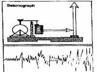
Answer: (2) Seismograph

Question 20. A majority of earthquake occur along
(1) Plate Boundaries
(2) River valleys
(3) Ocean beds
(4) Plateau region

Answer: (1) Plate Boundaries

Question 21. Destructive Tsunamis bring about
(1) Earthquake
(2) Destructive coastal flood
(3) Lava flow
(4) Volcanic eruption

Answer: (2) Destructive coastal flood

Class ix Geography Book WBBSE

Question 22. The belt accounts about 65 percent of the total earthquakes in the world is-
(1) Mid-continental belt
(2) Mid-Atlantic belt
(3) Circum pacific belt
(4) Other belts

Answer: (3) Circum pacific belt

Question 23. Sea waves caused by the submarine earthquakes are called-
(1) Hypocentre
(2) Epic entre
(3) Seismic waves
(4) Tsunamis

Answer: (4) Tsunamis

Question 24. A natural hazard is :
(1) A flood, earthquake or similar unpredictable natural event
(2) An extreme natural phenomenon that causes death and destruction
(3) People located in a natural environment that may disrupt or threaten their safety and property
(4) An unpredictable event that disturbs the natural order of the environment

Answer: (4) an unpredictable event that disturbs the natural order of the environment

Question 25. Pre-disaster planning will make possible :
(1) The prevention of the disaster
(2) The effective application of aid where prevention is not possible
(3) Anticipating the consequences of a disaster
(4) All of the above

Answer: (4) All of the above

Question 26. A disaster is defined according to :
(1) Its human consequences
(2) Its cause
(3) The number of deaths it causes
(4) Its measurable severity

Answer: (1) Its human consequences

Question 27. Although each type of disaster can have a different cause, they all cause predictable problems in the following areas :
(1) Environment and health —
(2) Administration and managerial
(3) Social and economic
(4) 1, 2, and 3

Answer: (4) 1, 2, and 3

Question 28. The majority of lives lost in an earthquake are caused by :
(1) Floods
(2) Landslides
(3) Fire
(4) Building collapse

Answer: (4) Building collapse

Question 29. During an earthquake the walls of buildings without lateral bracing :
(1) Create a whiplash effect
(2) Fall outward
(3) Fall inward
(4) Remain standing

Answer: (2) Fall outward

Question 30. A house most vulnerable to an earthquake would typically be :
(1) Built of flimsy wood materials
(2) Built of heavy materials without frame reinforcement
(3) Built of heavy materials without a solid foundation
(4) Built with a weak roof and weak walls

Answer: (2) built of heavy materials without frame reinforcement

Question 31. Intensity is a measure of :
(1) Human experience during an earthquake as measured on the Richter scale
(2) Energy released during an earthquake as measured on the Mercalli scale
(3) Human experience during an earthquake as measured on the Mercalli scale
(4) Energy released during an earthquake as measured on the Richter scale

Answer: (3) Human experience during an earthquake as measured on the Mercalli scale

Question 32. The basis for the theory of continental drift is :
(1) Plate tectonics
(2) Pressure building up within the earth’s crust
(3) The earth’s land area once was a single mass
(4) Divergent rifts between continental land masses

Answer: (3) The earth’s land area once was a single mass

Question 33. The best method for avoiding loss of life from tsunamis is :
(1) Human-made seawalls of adequate size and length
(2) Participation in a tsunami warning system
(3) Timely evacuation of people from areas prior to flooding
(4) An extensive program of emergency medical assistance

Answer: (3) Timely evacuation of people from areas prior to flooding

Class ix Geography Book WBBSE

Question 34. The majority of tsunamis take place in :
(1) Earthquake zones
(2) The Pacific Ocean
(3) The Indian Ocean
(4) The coastline of Indonesia

Answer: (2) The Pacific Ocean

Question 35. Tsunamis travel at a speed :
(1) That can exceed 1,000 kilometers per hour
(2) That increases as they approach land
(3) That allows ample time for warning populations
(4) Proportional to the vertical depth of the displaced column of water

Answer: (1) That can exceed 1,000 kilometers per hour

Question 36. The majority of volcanoes are located in :
(1) The circum-Pacific belt
(2) The mid-Atlantic line
(3) East Africa
(4) The African Rift Valley

Answer: (1) The circum-Pacific belt

Question 37. The basic ingredients of a volcanic eruption are :
(1) Gases and molten rock
(2) Gases and pumice
(3) Ash and gases
(4) Magma and lava

Answer: (1) Gases and molten rock

Question 38. A dangerous secondary effect of an island volcanic eruption may be :
(1) Ash fall on nearby islands
(2) Lava flows into the waterfront
(3) Tsunamis on nearby coastal areas
(4) Severe oceanic wave disturbances

Answer: (3) Tsunamis on nearby coastal areas

School Geography Class 9 Solutions WBBSE

Question 39. A  sudden break in volcanic activity during an eruption period generally means :
(1) The danger is over
(2) Immediate evacuation of the area may be necessary
(3) An increased need for monitoring
(4) Increased earthquake activity within the plate area

Answer: (2) Immediate evacuation of the area may be necessary

Question 40. Useful volcanic prediction methods currently under study use :
(1) Frequency of tremors
(2) Upward movement of magma
(3) Analysis of chemical content of volcanic gases
(4) Infrared air photographs

Answer: (1) Frequency of tremors

Question 41. A volcanic disaster will pose both :
(1) An immediate and a long-term disease problem
(2) Loss of crops and disruption of migration
(3) Deaths and high surgical needs
(4) Loss of crops and disruption of markets.

Answer: (4) Loss of crops and disruption of markets.

Question 42. Cyclones cannot develop when the ocean temperature is below 24 degrees Centigrade (76°F) because :
(1) Of insufficient heat
(2) Of insufficient temperature difference between the air and water
(3) Cooler water temperatures prevent doldrums
(4) Of insufficient evaporation

Answer: (4) Of insufficient evaporation

Question 43. When two wind currents travel side by side, the faster current :
(1) Curls away from the slower one
(2) Curls away from the vorticity of the earth’s force
(3) Curls in the directon of the earth’s rotation
(4) Curls around the slower one

Answer: (4) Curls around the slower one

Question 44. Wind velocity is measured :
(1) On the Saffir/Simpson scale.
(2) By the National Hurricane Center in the Hawaiian Islands.
(3) On the Richter scale.
(4) On the Beaufort scale.

School Geography Class 9 Solutions WBBSE

Answer: (4) On the Beaufort scale.

Question 45. Tropical cyclones often generate :
(1) High rates of injured people
(2) Tidal floods
(3) Very heavy rainfall
(4) Agricultural soil erosion

Answer: (3) Very heavy rainfall

Question 46. Modern technology usually first identifies and follows a cyclone using :
(1) World Weather Watch
(2) Satellite photos
(3) Weather radar
(4) Automatic weather stations

Answer: (2) Satellite photos

Question 47. Errors in cyclone forecasting are ;
(1) Seldom
(2) Frequent
(3) Increasing
(4) Declining

Answer: (4) Declining

Question 48. Cyclone disasters can create a climate :
(1) Different from previous temperatures and humidity
(2) That will cause more cyclones within six months
(3) That will induce long-term rainfall
(4) Where negative social changes will result

Answer: (1) Different from previous temperatures and humidity

Question 49. Houses damaged in a cyclone usually :
(1) Explode
(2) Get blown over
(3) Collapse
(4) Remain standing

Answer: (4) Remain standing

Question 50. The primary measurement of flood damage is :
(1) The quantity of water discharged
(2) How high the water goes above normal restraints
(3) The dollar amount of economic damage
(4) The number of deaths

School Geography Class 9 Solutions WBBSE

Answer: (2) How high the water goes above normal restraints

Question 51. Flash floods may result from :
(1) Dam failures or cloudbursts
(2) Riverine terrain and conditions
(3) Rainfall due to tropical cyclones
(4) Inadequate catchment areas

Answer: (1) Dam failures or cloudbursts

Question 52. Timing and reliability of flood warnings: Timing and reliability of flood warnings :
(1) Are difficult to insure
(2) Decrease as the downstream distance increases
(3) Increase as the downstream distance increases
(4) Are easy to insure using Landsat technology

Answer: (3) Increase as the downstream distance increases

Question 53. A severe flood in a rural area could cause :
(1) A substantial increase in snakebite victims
(2) A housing shortage in the cities
(3) Little damage if the waters stagnate
(4) Little effect on the national economy of an industrial nation

Answer: (2) A housing shortage in the cities

Question 54. Active floodproofing is most effective : .
(1) With long warning lead times
(2) In flash-flood areas
(3) If it is permanent
(4) In floodplain areas

Answer: (1) With long warning lead times

Question 55. An effective flood-control master plan will have :
(1) A public information program
(2) Local government support
(3) Insufficient funding
(4) 1, 2, and c

Answer: (4) 1, 2, and c

WBBSE Class 9 Geography Chapter 6 Solved Exercises

Question 56. One reason why misery due to drought is increasing on a worldwide basis is :
(1) An increase in world population
(2) A decrease in rainfall worldwide
(3) An increase in human activities that aggravate drought conditions
(4) a decrease in water table levels

Answer: (3) An increase in human activities that aggravate drought conditions

Question 57. Long-term drought can cause changes in social and living patterns.
(1) Temporary
(2) Major ecological
(3) Permanent
(4) Minor

Answer: (3) Permanent

Question 58. During a drought, it is important that :
(1) People get relief supplies as near to their homes as possible
(2) People leave their homes and migrate to a water source
(3) Livestock is reduced to allow ample supplies for humans
(4) That a program be implemented to impress the public with the seriousness of the problem

Answer: (1) People get relief supplies as near to their homes as possible

Question 59. The study of earthquake is :
(1) Seismology
(2) Siesmology
(3) Etomology
(4) Phorosics

Answer: (1) Seismology

Question 60. During tsunamis, the largest wave is the wave.
(1) First
(2) Second
(3) Unpredictable, could be any of them
(4) Third

Answer: (3) Unpredictable, could be any of them

School Geography Class 9 Solutions WBBSE

Question 61. Tsunamis are destructive due to their :
(1) height of the wave
(2) Uncertainty
(3)Momentumandlongwavelength
(4) Temperature

Answer: (3) Momentum and long wavelength

Question 62. Drought is :
(1) A year without rainfall
(2) A week without rain
(3) Water scarcity over a long period
(4) A season without rain

Answer: (3) Water scarcity over a long period

Question 63. Flood is :
(1) Excessive rain
(2) Water overflows to submerge land
(3) Excess water
(4) Excessive water depth

Answer: (2) Water overflows to submerge land

Question 64. The naming of tropical cyclones is useful :
(1) For reporting
(2) for the forecasters
(3) For research
(4) For tracking, forecasting, and reporting

Answer: (4) For tracking, forecasting, and reporting

Question 65. Pre-disaster management includes :
(1) Prevention
(2) Mitigation
(3) Response
(4) (1) and (2)

Answer: (4) (1) and (2)

Question 66. The charge of disaster management just after independence was with :
(1) Ministry of Water Resource
(2) Ministry of Home Affairs
(3) Relief Commissioners
(4) Ministry of Human Resource

Answer: (3) Relief Commissioners

Question 67. The Disaster Management Act was enacted in :
(1) 2005
(2) 2002
(3) 2006
(4) 2000

Answer: (1) 2005

Question 68. Match the following meteorological scales with the phenomena :
1. Richter A. Hurricane
2. Fujit B. Wind
3. Saffir- Simpson C. Earthquake
4. Beaufort D. Tornado
(1) 1A, 2D, 3A, 4B
(2) 1A, 2D, 3B, 4C
(3) 1D, 2C, 3B, 4A
(4) 1C, 2A, 3B, 4D

Answer: (1) 1A, 2D, 3A, 4B

Question 69. Ambutia in Darjeeling was known for
(1) landslide
(2) Earthquake
(3) Flash flood
(4) None

Answer: (1) landslide

Question 70. The intensity of earthquake by observation is measured by :
(1) Richter scale
(2) Mercalli scale
(3) Both Richter and Mercalli scale
(4) None

Answer: (2) Mercalli scale

School Geography Class 9 Solutions West Bengal Board

Question 71. The threshold for a quake to cause damage on a Richter scale is :
(1) 2
(2) 3
(3) 6
(4)7
Answer:(4)7

Question 72. Turbidity is measured by :
(1) Solarimeter
(2) Nephelometer
(3) Pyranometer
(4) None

Answer: (2) Nephelometer

Question 73. Tsunamis literally mean :
(1) Huge wave
(2) Wave series
(3) Tremors
(4) Harbour wave

Answer: (4) Harbour wave

School Geography Class 9 Solutions West Bengal Board Chapter 6 Hazards And Disasters Short Questions With Answers:

Question 1. What is seismology?
Answer:

Seismology

The science of earthquakes is known as Seismology (from the Greek word seismos, meaning earthquakes).

Question 2. What do you refer to as hypocentre or focus?
Answer:

Hypocentre

The place of origin of an earthquake inside the earth is called its hypocentre or focus.

Question 3. What do you mean by volcanic eruptions?
Answer:

Volcanic eruptions

Volcanic eruptions are often very violent and cause earthquakes.

Question 4. What are Artificial Earthquakes?
Answer:

Artificial Earthquakes

These are caused by human activities. Minor tremours due to running trains, heavy machines, and bomb explosions are of this type.

Question 5. What is meant by Richter Scale?
Answer:

Richter Scale

The scale which measures the magnitude of an earthquake is called Richter Scale..

Question 6. Explain the following: Seismograph.
Answer:

Seismograph

Seismograph is the instrument which is used for recording earthquake waves and earthquake vibrations.

Question 7. Explain the following: Seismic Focus
Answer:

Seismic Focus

Seismic Focus is the point beneath the crust from where seismic waves originate.

Question 8. What are two belts of earthquakes and volcanoes in the world?
Answer:

The two belts of earthquakes and volcanoes in the world are :

(1) Ring of the Pacific Ocean
(2) Alpine Himalayan region.

Question 9. What is called the ring of fire?
Answer:

Ring of fire

The ring of Pacific Ocean (ring of earthquakes and volcanoes) is also called ring of fire.

Question 10. What is avalanche?
Answer:

Avalanche: A fall or slide of a large mass of snow or rock, down from a mountain.

Question 11. what is Blizzard?
Answer:

Blizzard: Blizzards are severe winter storms that pack a combination of blowing snow and wind resulting in very low visibilities.

Question 12. What is Cyclone?
Answer:

Cyclone: It’s an atmospheric pressure distribution characterized by the rapid, spiraling inward circulation of air masses about a low-pressure centre.

School Geography Class 9 Solutions West Bengal Board

Question 13. What do you mean by Drought?
Answer:

Drought: Drought is said to happen when extremely dry weather pre-vails at an area due to less rainfall than its normal amount, over months together or even years, causing a hurdle for agriculture.

Question 14. Define Earthquake.
Answer:

Earthquake: An earthquake is the result of a sudden release of Earth’s internal energy in the crust that creates seismic waves.

Question 15. Define Flood.
Answer:

Flood: A flow of water from a water body like sea, ocean, river etc., deviating the normal path of flow of water into a dry land.

Question 16. Define Forest fire.
Answer:

Forest fire: A forest fire is an uncontrolled fire occurring in forest.

Question 17. What is Landslide?
Answer:

Landslide: “Landslide” describes a large mass of rocks and earth that suddenly and quickly slides down along the slope of a mountain or hill.

Question 18. What is Tsunami?
Answer:
Tsunami: An unusual and very large ocean wave caused by an underwater earthquake at the ocean-bed or underwater volcanic eruption.

Question 19. Define Volcanism.
Answer:

Volcanism: A volcano is a rupture on the crust of the Earth (either in land or at ocean) from where hot lava, volcanic ash, and gases emerge from magma chamber due to increase in internal pressure the of the Earth.

Question 20. Define Hazard.
Answer:

Hazard

Hazard, a naturally occurring physical phenomenon, may be defined asa dangerous condition or situation, which threat to or cause havoc damage to human property including casualties in a large scale.

Class 9 Geography Hazards And Disasters WBBSE Notes

Question 21. Which natural disaster claims maximum number of human lives on a regular basis?
Answer: Floods.

Question 22. How many people were killed by Krakatoa eruption in Sunda strait in 1883?
Answer: 50,000.

Question 23. Which scale is used to measure the magnitude of earthquakes?
Answer: Richter scale.

Question 24. Intensity of earthquakes is measured by which scale.
Answer: Mercalli scale.

Question 25. Which part of India is most prone to earthquakes?
Answer: The Himalayan region. :

Question 26. Which part of South India is frequently influenced by droughts?
Answer: Rain-shadow area of the Western Ghats.

Question 27. Name the area in North-East India which is affected by floods almost every year.
Answer: The Brahmaputra valley.

Question 28. Name two areas in India which have high incidence of landslides.
Answer: The Himalayas and the Western Ghats.

School Geography Class 9 Solutions West Bengal Board Chapter 6 Hazards And Disasters True Or False Blanks

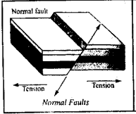
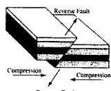
Question 1. Earthquakes may cause vertical and lateral displacement of the earth’s crust.
Answer: True

Question 2. Volcanic activity may cause earthquakes.
Answer: True

Question 3. Volcanic activities is very common in the Pacific Ocean area.
Answer: True

Question 4. Earthquake causes landslides.
Answer: True

Question 5. Gigantic sea waves are known as tsunamis.
Answer: True

Question 6. Himalayas is an earthquake-prone area.
Answer: True

Question 7. Richter Scale records earthquake.
Answer: False

Question 8. Tsunamis are caused by earthquake under the Sea.
Answer: True

Question 9. Epicentre is the shortest distance between the focus and the earth-crust_.
Answer: True

Question 10. In ancient time people believe disaster as evil star on bad star.
Answer: True

Question 11. In West Bengal, two drought-prone districts are Bankura & Purulia.
Answer: True

Question 12. When blocks of ice fall down from high altitude then it is termed as waterfalls.
Answer: False

Question 13. Tsunamies are the effects of cyclones.
Answer: False

School Geography Class 9 Solutions West Bengal Board

Question 14. The cyclones of Caribbean islands are called typhoons.
Answer: False

Question 15. Forest fires are un controlled spread of fire occurring in a forest.
Answer: True

Question 16. The phenomenon of eruption of molten magma on to the surface is calledflood.
Answer: False

Question 17. The severe winter storm that is associated with blowing snow and wind is called avalanche.
Answer: False

WBBSE Solutions Guide Class 9 Chapter 6 Hazards And Disasters Distribution Volcanoes, Earthquake Belt And Lava Plateaus Fill In The Blanks

Question 1. The point where slip or rupture of plates takes place is called the __________________ of the earthquake.
Answer: Focus.

Question 2. ___________ is a situation which occurs by acute deficiency of rainfall in a region.
Answer: Drought.

Question 3. The movement of soil, rock or other earth materials downhill by gravity is called a________________.
Answer: Landslide.

Question 4. ______________measures the severity of earthquake.
Answer: Richtre scale.

Question 5. ______________ is an earthquake recording instruments.
Answer: Seismograph.

Question 6. ________________ is a huge sea wave.
Answer: Tsunami.

Question 7. ________________mountains are the weak portion of earth.
Answer: Fold.

WBBSE Solutions Guide Class 9 Chapter 6 Hazards And Disasters 2 Marks Questions And Answers

Question 1. What do you mean by cyclone?
Answer:

Cyclone

Cyclone ’is a region of low atmospheric pressure surrounded by high at- mospheric pressure resulting in swirling atmospheric disturbance accompained by powerful winds blowing in anticlockwise direction in the Northern Hemisphere and in the clockwise direction in the Southern Hemisphere.

Question 2. Mention the flood-prone area in West Bengal.
Answer:

The flood-prone area in West Bengal

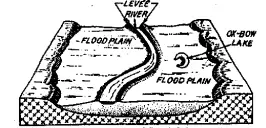
In West Bengal, flood-prone areas include, the Ganga delta in the South, and the northern plains drained by the Tista and Torsa in the northern parts of West Bengal. There are occasional floods in Damodar and Kanshaboti basin. Dams have been constructed on them to control flood condition as well as to irrigate land during dry season.

Question 3. State the types of hazards.
Answer:

Types of hazards

There are two types of hazards we often see. One is Natural Hazard and the other is Manmade Hazard.

Natural hazards :

Hazards, which are caused by natural phenomena or events, are called natural hazards.

Examples: cyclones, tsunamis, earthquakes, volcanic eruptions which are exclusively of natural origin. Somethimes forest fire may also pose as natural hazard caused by lightning or volcanic eruption.

Manmade hazards :

Hazards which are caused due to human negligence are called manmade hazards.

Example : Deforestation, Forest fire, Food poisioning, Environmental pollution etc.

Question 4. From where does the word disaster came from?
Answer: The word disaster is originated from either French word ‘Disastro’ or Ital- ian word ‘Diasastor’ or Greek word ‘Disaster’. French word ‘des’ or Latin word ‘dis’ or ‘de’ or ‘di’ mean bad/evil and ‘astre’ mean star. So bad star or evil star. {dis/de/di] + [astron/star] = disaster.

Question 5. What do you mean by a blizzard?
Answer:

Blizzard

A blizzard is a severe snowstorm characterized by strong sustained winds of at least 56 km/h (35 mph) and lasting for a prolonged period of time – typically three hours or more. A ground blizzard is a weather condition where snow is not

Question 6. What are the effects of blizzard?
Answer:

Blizzards

Blizzards can be dangerous, especially when driving an automobile. It creates a fog like mist called a “white out” which is thicker than a fog. Many accidents happen because of the thick mist.

If a blizzard is cold enough it could cause a person with proper clothing to get frosbite or hypothermia, It can cause power outage that can last for hours and also causes snow to pile a more than 10 inches.

Question 7. What do you mean by landslides? OR, Write a short note-on landslide.
Answer:

Landslides

A landslide, also known as a landslip, is a geological phenomenon that includes a wide range of ground movements, such as rockfalls, deep failure of slopes and shallow debris flows. Landslides can occur in offshore, coastal and onshore environments.

Although the action of gravity is the primary driving force for a landslide to occur, there are other contributing factors affecting the original slope stability. Typically, pre-conditional factors build up specific sub-surface conditions that make the area/slope prone to failure, whereas the actual landslide often requires a trigger before being released.

Class 9 Geography Solution WBBSE

Question 8. What is Epicentre?
Answer:

Epicentre

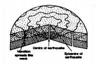
The place or point in the interior of the earth, where an earthquake takes its origin is called Focus or Centre. Vertically above the centre, the point or place on the surface of the earth is known as epicentre.

Here at the epicentre the quaking of the earth is first experienced and the intensity of the quake is most severe. The earthquake waves move in other directions from this epicentre and farther away from this epicentre, the intensity decreases.

WBBSE Solutions For Class 9 Geography And Environment Chapter-6 Hazards And Disasters Centre And Epicetre Of Earthquake


Question 9. What is the function of seismograph?
Answer:

Function of seismograph

It is used to measure earth-quake.

Question 10. Why do earthquakes frequently strike both the coasts of Pacific Ocean ?
Answer: It is known that plates which are boundaring, are very much unstable in characte- ristic. They are always sliding or moving to each other. This movement generate earthquake. The coast of Pacific Ocean lies in plate boundaries. So, earthquakes are frequent strike both the coasts of the Pacific Ocean.

Question 11. What is the difference between an earthquake and an earth movement? (S.Question)
Answer:

The difference between an earthquake and an earth movemen

The sudden shaking of earth’s crust for a short duration due to several causes (such as plate movements, volcancity, making of dams on rivers etc.) is called earthquake. On the other hand, due to internal disturbances of the earth’s interior, the crust of the earth may be uplifted, down wraped or folded.

This is known as earth movement. Both are closely associated but earthquake is just the shaking of earth’s crust, whereas, earth movement involves lateral or vertical movement of the earth’s crust.

Question 12. At which depth do most earthquakes occur?
Answer:

An earthquake is a shaking of the crust of the earth. Itis a sudden jerk or movement of the earth’s crust. It is a great shock or tremor of the crust of the earth that originate naturally beneath the earth’s surface.

Class 9 Geography Solution WBBSE

Question 13. What is Seismograph?
Answer:

Seismograph

Seismograph is an instrument which records earthquake shocks. In this instruments, vibrations are recorded by a pen tracing on a revolving drum attached with graph. Modern Seismographs are so sensitive that they record vibrations of earthquakes thousands of kilometers away.

WBBSE Solutions For Class 9 Geography And Environment Chapter-6 Hazards And Disasters Seismograph

Class 9 WBBSE Geography Chapter 6 Important Question

Question 14. What is ‘Pacific Ring of Fire’?
Answer:

Pacific Ring of Fire

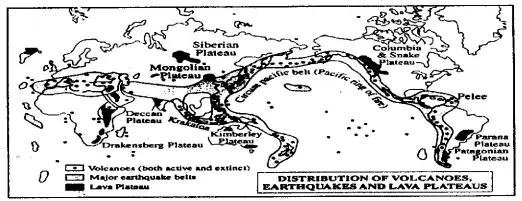
Circum Pacific Earthquake Belt is known as the ‘Pacific Ring of Fire’. There are a large number of active and dormant volcanoes in this belt. It encircles the Pacific Ocean including Western coast of North and South America, the Aleution Islands, and the Islands of Asia like Japan, Philippines, and Indonesia etc.

This is a region of young fold mountains. This belt has weak earth’s crust due to whichn the crustal movements and eruptions volcanoes are frequent. Fujiyama of Japan, Krakatoa in Indonesia, Chimborazo, and Cotap in South America are within this belt. About 70% earthquakes of the world occur in this belt.

Chapter 6 Hazards And Disasters 2 Marks Questions And Answers (Short Notes)

Question 1. Earthquake waves
Answer:

The earthquake waves are of three types –

(1) Primary Waves –
These are the fastest waves. These waves create maximum disaster. SPEED: 7.8 km/Sec.

(2) Secondary waves –
These are the second fast waves. These travel in opposite direction to that of primary waves. SPEED :5-6 km./Sec.

(3) Surface waves –
These are slowest of all the waves. These waves are capable of travelling at the Earth’s surface. SPEED : 3 – 4 km./Sec.

Class 9 Geography Solution WBBSE

Question 2. What is Ritchter scale? :
Answer:

Ritchter scale

Ritchter Scale is the scale which measures the intensity of an earthquake. The Ritcher Scale was devised by Prof. Ritcher, an eminent American Seismologist. The scale measures the intensity of an earthquake, the scale is based on instrumental recordings of a seismograph.

Question 3. The effects of earthquakes.
Answer:

The effects of earthquakes

The effects of eartnquakes are both destructive and constructive, although destructive effects are much more.

Destructive effects :(1) It can alter the course of a river. The earthquake of 1950 changed the course of the Brahmaputra river.
(2) Sea waves reach greater heights and speed sometimes 500 to 800 km. per hour. These disastrous sea waves are known as “Tsunamis” (along the Japanese sea coast). Due to this adjoining coastal region is suddenly flooded and there is unimaginable loss of lives and property.
(3) Landslides occur in the mountainous areas.
(4) The ground rises and falls resulting in the cracks of rocks and buildings collapse resulting in the death of thousands of people.
(5) Bridges, roads etc. are damaged.
(6) Dislocation of electric wiring takes place and fire breaks out.

Constructive effects :
(1) From the interior of the earth, variety of unknown minerals come out on the surface.
(2) Lava comes out and after consolidation above the earth’s surface make the soil fertile.
(3) Coastal plains and lakes are created. These are useful for human.

Question 4. Tsunamis.
Answer:

Tsunamis

When a submarine earthquake causes a considerable movement of sections of the ocean floor, great mass of water come into motion and waves of a peculiar kind called Tsunami are formed on the surface of the ocean (In Japan, ‘tsu’ means harbour and ‘nami’ means waves).

Tsunami move along the ocean surface at a very high speed of upto 400 to 800 km per hour and cover tremendous distances. In open ocean the Tsunami waves are very long but they are not high but as they approach the shore, their height increases to almost 9 metres above normal tide level. These waves cause wide spread destruction crashing on the shore and travelling far inland in coastal areas.

Class 9 Geography Chapter 6 WBBSE

Question 5. Centre and epicentre of an earthquake.
Answer:

Centre and epicentre of an earthquake

The place or point, in the interior of the earth, where an earthquake takes its origin is called Focus or Centre. Vertically above the centre, the point or place on the surface of the earth is known as epicentre.

Here at the epicentre the quaking of the earth is first experienced and the intensity of the quake is most severe. The earthquake waves move in other directions from this epicentre and farther away from this epicentre, the intensity decreases.

Question 6. Recent Earthquakes.
Answer:

Some of the most destructive earthquakes of the world in the recent past are :

(1) The earthquake of Mexico City which occured on 19th September in 1995.
(2) The earthquake of Armenia (Russian Federation) on December, 1988.
(3) The earthquake of Hokkaido in Japan in 1993 and
(4) The earthquake of Kobe in Japan on 17th January, 1995.

Chapter 6 Hazards And Disasters 3 Marks Questions And Answers

Question 1. State the cause of occurrence of Drought.
Answer:

Cause of occurrence of Drought.

(1) Drought is defined as a deficit of rain water. We know that deficiency of water vapour in the atmosphere of an area cause less rainfall. If high pressure and dry air prevails in an area for a prolonged time period, less moisture is generated in that area which is burden to produce precipitation (because these systems cannot hold as much water vapour). This results in a deficit of water for those areas.

(2) Sometimes, warm, dry, continental air moves over an area in contrary to cooler, moist, oceanic air, due to shifting of air masses by wind. El Nino, which affects the ocean’s water temperature, also has an impact on precipitation levels, because it can shift the air masses above the ocean, often making wet places
dry (drought prone).

(3) Deforestation for agriculture and/or building combined with the resultant erosion can also cause drought. As soil is moved away from an area it is less able to absorb moisture when it falls.

Class 9 Geography Chapter 6 WBBSE

Question 2. State the flood prone regions in India.
Answer:

The flood prone regions in India

The lower plain region of India specially Bihar, Uttar Pradesh and West Bengal in respect of the Ganga and Assam in respect of Brahmaputra suffer from the adverse effects of flood every year. The Ganga Brahmapuitra Basin receives maximum run off within the three monsoon months. Based on hydrological studies carried out, it is estimated that only 18% of the rain water can be stored in dams, reservoirs, etc. While 82% of the rain water flows through rivers ultimately into the sea.

Question 3. State the drought-prone areas in the world.
Answer:

Drought-Prone Area :

(1) Sahal region of Africa :

Sahal means the edge of Sahara desert which is excessive drought prone area of the world. This region was affected by drought during 1905-1909, 1950-1969, 1973, 1984, 1990 and 2007.

(2) Drought-Prone region of India :
Around 68% of India’s total area is droughtprone. 315 out of a total of 725 talukas in 99 districts are drought prone. In 2001 more than eight states suffered the impact of severe drought.

Question 4. State three remedies of Drought.
Answer:

Remedies :

(1) Public awareness and education
(2) restoration of ecological balance by conserving, developing and harvesting land, water, livestock and human resources.
(3) to minimise the adverse effects of drought on production of crops and livestock.

Question 5. Mention the remedies to be taken for flood prevention.
Answer:

Remedies: As flood is a natural hazard we can take few types of measures for remedies. Some measures can be taken
(1) Before flood such as creation of forest, construction of dams, dykes and reservoirs etc., regular removal of silt from the river bed, digging of waterbodies, forecasting about flood, renovation of river bed and river banks etc.

(2) After flood supply of adequate drinking water, dry food, rescue of flood-prone people, sufficient supply of geoline, bleaching powder etc., recovery of dead bodies and their disposal, proper medical care for people, temporary shelter like camps, metal sheds, tents etc.

After devastating flood in 1954, the government of India announced a National Flood Management Programme, The programme was divided into three phases—
(1) Immediate,
(2) Short-term and
(3) Long-term.

(1) Immediate phase :
Extending over a period of 2 years was adopted for intensive collection of data and execution of emergent flood protection measured.

(2) Short terms measures :
Covering next 4 to 5 years, included construction of spurs and embankments at selected sites.

(3) Long-term measures :
Included the construction of storage, reservoirs on rivers/tributaries and additional embankments.

The Central Water Commission (C.W.C) started flood forecasting in 1958 when the first forecasting station was established at old Railway Bridge, Delhi.

Class 9 Geography Chapter 6 WBBSE

Question 6. Briefly explain hazard & disaster. Or, Hazared is the cause and disaster is the effect. Explain.
Answer:

Hazard

Hazard, a naturally occurring physical phenomenon, may be defined asa dangerous condition or situation, which threat to or cause havoc damage to human property including casualties in a large scale.

Disater, happens when a hazard impacts on the population resulting in substantial and significant physical damage or destruction, loss of life, or drastic change to the environment. Due to a disaster a serious disruption happens to the functioning of a society of mankind.

The losses occur due to such disaster some times may exceed the ability of the affected society to recover the situation by using its own resources. Ahazard becomes a disaster only when it affects human settlements and causes loss of life and damage to property. So Hazard is the cause and the Disaster is the effect.

Question 7. What are the different names of cyclone?
Answer:

Cyclones are known by different names in different parts of the world:

1. Typhoons in the Northwest Pacific Ocean west of the dateline

2. Hurricanes in the North Atlantic Ocean, the Northeast Pacific Ocean east of the dateline, or the South Pacific Ocean.

3. Tropical cyclones – the Southwest Pacific Ocean and Southeast Indian Ocean.

4. Severe cyclonic storm (the North Indian Ocean)

5. Tropical cyclone (the Southwest Indian Ocean)

6. Willie-Willie in Australia

7. Tornado in Gulf of Mexico

Question 8. What are the characteristics of a cyclone?
Answer:

Cyclones in India are moderate in nature.Some of the general characteristics of a cyclone are :

(1) Strong winds
(2) Exceptional rain
(3) Storm surge
Cyclones are generally accompanied by strong winds which cause a lot of de- struction. In some cases it is accompanied by heavy downpour and also the rise in the sea which intrudes inland thereby causing floods.

Question 9. What do you mean by disaster ?
Answer:

Disaster

Disaster is an incident or series of events that gives rise to casualties and loss or destruction of surroundings, buildings, properties, infrastructural facilities and all other vital services or survival means to such an extent that is a far from the normal means and competence of the people affected in order to deal with it.

WBBSE Class 6 Geography Chapter 6 Question Answer

Disaster can be defined as “catastrophic situation in which the normal pattern of life or eco-system has been disrupted and extra-ordinary emergency interventions are required to save and preserve lives and or the environment”.

The United Nations defines disaster as “the occurrence of sudden or major misfortune which disrupts the basic fabric and normal functioning of the society or community”.

As per the Disaster Management Act, 2005, disaster is defined as “a catastrophe, mishap, calamity or grave occurrence in any area, arising from natural or manmade causes, or by accident or negligence which results in substantial loss of life or human suffering or damage to, and destruction of, property, or damage to, or degradation of, environment, and is of such a nature or magnitude as to be beyond the coping capacity of the community of the affected area”.

Hazards And Disasters Class 9 WBBSE Short And Long Answers

Question 10. State the characteristics of disaster.
Answer:

The major characteristics of a disaster are :
(1) Inevitability or certainty.
(2) Ability to be forbidden.
(3) Pace of onset.
(4) Span of forewarning.
(5) Extent of impact.
(6) Scope and intensity of impact.

Question 11. State the objectives of disaster management plan.
Answer:

General Objectives of a Disaster Management Plan are :
(1) To guarantee the safety, security and stability- to secure business sites and facilities, to safeguard and make available critical resources, to ensure supply of equipments, to make sure security and resurgence of accounts from expected disasters, to protect all the vital information and records.

(2) To reduce the risk of disasters caused by human error. To be well equipped in order to pull through from a major natural disaster.

(3) To recover lost or damaged records or information ensuring the organization’s capacity to carry on its operation and service even post- disaster period (sustainability).

Question 12. State the principles of disaster management.
Answer:

Principles of Disaster Management are :

(1) Disaster management is the accountability at all levels of government.

(2) Disaster management arrangements must identify the contribution and pro- spective role of non-government agencies.

(3) Disaster management to utilize existing resources for daily purpose.

(4) The concerned organizations should work and endeavor as a supplement to their central business.

(5) Persons are to be responsible for their own safety.

(6) Planning of disaster management should be focusing on large-scale episodes.

WBBSE Class 6 Geography Chapter 6 Question Answer

Question 13. What is a Hazard? How is it classified ?
Answer:

Hazard

Hazard may be defined as “a dangerous condition or event, that threaten or have the potential for causing injury to life or damage to property or the environment.” The word ‘hazard’ owes its origin to the word ‘hasard’ in old French and ‘az-zahr’ in Arabic meaning ‘chance’ or ‘luck’.

Hazards can be grouped into two broad categories namely natural and manmade

(1) Natural hazards are hazards which are caused because of natural phenomena (hazards with meteorological, geological or even biological origin). Examples of natural hazards are cyclones, tsunamis, earthquake and volcanic eruption which are exclusively of natural origin. Landslides, floods, drought, fires are socionatural hazards since their causes are both natural and man-made. For example flooding may be caused because of heavy rains, landslide or blocking of drains with human waste.

(2) Manmade hazards are the hazards which are due to human negligence. Manmade hazards are associated with industries or energy generation facilities and include explosions, leakage of toxic waste, pollution, dam failure, wars or civil strife etc.

Question 14. Give a chart explaining various types of hazards.
Answer:

Types of Hazards :

Geological Hazards

1. Earthquake
2. Tsunami
3. Volcanic eruption
4. Landslide
5. Dam burst
6. Mine Fire

Water And Climatic Hazards

1. Tropical Cyclone
2. Tornado and Hurricane
3. Floods
4. Drought
5. Hailstorm
6. Cloudburst
7. Landslide
8. Heat And Cold wave
9. Snow Avalanche
10.Sea erosion

Environmental Hazards

1. Environmental pollutions
2. Deforestation
3. Desertification
4. Pest Infection

Biological Hazards

1. Human / Animal Epidemics
2. Pest attacks
3. Food poisoning
4. Weapons of Mass Destruction

WBBSE Class 6 Geography Chapter 6 Question Answer

Question 15. Describe different types of earthquakes.
Answer:

Earthquakes have main two types –

(1) Natural Earthquake –

Those earthquakes that are caused due to nature are called natural earthquakes. Natural earthquake has 3 main sub – divisions.

(1) Tectonic Earthquakes.
(2) Volcanic Earthquakes.
(3) Isostatic

(2) Artificial Earthquakes –

Those earthquakes that originaes due to human activities are called Artificial Earthquakes. Explosion of Atom bomb, Rail, Running of elephants etc. causes these types of Earthquakes.

Question 16. What are the factors responsible for earthquakes?
Answer:

The factors responsible for earthquakes

(1) Volcanic activity:-

Due to volcanic eruptions, earthquakes take place. Thus, in volcanic belts they are common. In 1883 severe earthquake occured due to the Krakatoa eruption and in 1985 Nevado Del Ruz eruption caused earthquake in Columbia. Lava flowing within crust may cause tremors on the surface.

WBBSE Solutions For Class 9 Geography And Environment Chapter-6 Hazards And Disasters Volcanic Eruption

(2) Tectonic movement:-

This is related to the Plate Tectonic Theory. When two plates converge each other from opposite directions or they scrape past against other an earthquake takes place. (This takes place by rubbing together the land masses). In 1967 the earthquake in Koyna was caused in this way. This happened along 400 km long Kurdawadi Rift (from SE of Sholapur to North of Pune).

At present the Gondawana plate is moving North at the rate of 5 centimetres a year. And it is feared that a mammoth earthquake measuring 8.5 on the richter scale is likely to occur in the next 10 to 15 years.

(3) isostatic Adjustment or Plutonic Earthquake :-
This is caused by the adjustment of sial and sima (sima – silica and magnesium and sial — silica and aluminium). Where the equilibrium is disturbed due to gradation by natural agent.

WBBSE Class 6 Geography Chapter 6 Question Answer Hazards And Disasters 5 Marks Questions And Answers

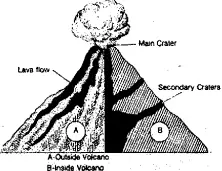
Question 1. Define the concept of volcanicity.
Answer:

Volcanicity

According to F.J. Monkhouse, the term volcanicity includes in its widest sense all the processes by which solid, liquid or gases materials are forced into the earth’s crust or escape on to the surface. In the words of S.W.

Wooldridge and R.S. Morgan, the term ‘Volcanicity’ covers all those processes in which molten rock materials or magma rises into crust or is poured out on its surface, there to solidity as a crystalline or semi crystalline rock. P.G.

Worcuster has used the term volcanism in place of volcanicity. According to him, volcanism includes all phenomenon connected with the movement of heated material from the interior to or towards the surface of the earth.

This activity has a greater effect on the surface features. The materials injected into the earth’s crust are known as intrusive rocks while in molten rock and other material which reaches in surface is called extrusive rocks.

Extrusive rocks build a variety of landforms varying from tiny cones to widespread sheets of lava. The molten rock material beneath the earth’s crust is known as magma which is normally maintained by overlying pressure. But when the pressure is locally relieved by the earth’s movements, various phenomena of volcanicity take place and magma comes out as lava.

Question 2. Describe the causes of volcanic eruptions.
Answer:

Causes of Volcanic Eruptions : Our knowledge regarding the causes of volcanic eruptions is very limited because these eruptions have their origin in the interior of the earth to which we do not have direct access. However, following causes are assigned to volcanic eruptions on the basis of indirect observations:

(1) High Temperature in the interior of the Earth :
The temperature increases with the increase in depth below the surface of the earth. This results in melting of rock material at high pressure in the earth. This molten material is ejected at the surface of the earth.

(2) Weak Points in Earth’s Crust :
The existence of weak points in the earth’s crust is a necessary condition for a volcanic eruption. The world distribution of
volcanoes is that most of the volcanoes have erupted in the weaker zones of the earth. The coastal areas are its best example.

(3) Gases :
The presence and formation of gases in the interior of the earth also cause volcanic eruption. Among the gases, water vapour is most effective. The rain water in contact with the hot interior of the earth after its percolation through the coast becomes water vapour. Sea water also percolates near the sea coast and becomes vapour. The heat and pressure increase many fold when water is converted into vapour. This water vapour comes to the surface through a weak point.

(4) Earthquakes :
The earthquakes are also responsible for crustal dislocations giving rise to the formation of faults. The release of pressure from the earth’s interior under dislocations causes the magma to escape to the surface.

(5) Plate Tectonics :
The rigid lithospheric slabs or rigid and solid crystal layers are known as plates. These plates keep on moving in different directions. Individual plates may have continental crust, oceanic crust or both. When an oceanic plate collides with continental plate, the denser oceanic plate is forced below the lighter continental plate. The overrun plate is thrust into the mantle and part of the plate is melted.

Melting also takes place due to heat created by pressure of rocks from above. The molten rock (magma) rises to the surface and a volcanic eruption takes place.

Question 3. What are different types of volcano according to their frequency ?
Answer:

(1) Active Volcanoes :
These volcanoes keep on ejecting volcanic mate- rial at frequent intervals. The Etna volcano of Italy has been active for the last 2500 years. The Stromboli volcano of Sicily island explodes after every 15 minutes and is known as the Light House of the Mediterranean.

(2) Dormant Volcanoes :
The dormant volcanoes are those in which eruption has not occurred regularly for a long time. But they cause great damage to life and property when they suddenly become active after remaining dormant for a sufficiently long time. Vesuvius volcano of Italy has exploded only 10 times in about 1500 years. The volcano of Barren Island to the East of Andamans in India exploded in 1991 after remaining dormant for several years.

(3) Extinct Volcanoes :
The volcanoes which have not recorded any eruption in historic times are called extinct volcanoes. The vent of an extinct volcano is blocked and its crater is filled with rain water to form a crater lake. Vegetation starts growing on it. The possibility of future explosion becomes remote. Popa of Myanmar is its outstanding example. Many a time, an extinct volcano suddenly becomes active.

This has happened in case of Krakatao volcano. The island of Krakatao is situated in the Sunda Strait between the islands of Java and Sumatra. Its eruption in the year 1883 blew off the top of the mountain by an explosion which caused tidal waves about 16 metres high, killing 36,000 people in West Java. The volcanic dust, ashes and smoke spread in about 27 km. the rock fragments and lava rose to a height of about 800 metres.

The sound of explosion was heard as far as Istanbul (Turkey) in the West and Tokyo in the East. The volcanic dust and gases encircling the globe in the atmosphere caused strange sunrise and sunset conditions for about three years. Today Krakatao is only a low island with a lake inside its crater.

Question 4. Describe the effects of Volcanic activities.
Answer:

Effects of volcanic activities :– Effects of volcanic activities are put into two categories as described below :

1. Destructive Effects :
Volcanoes are destructive. They cause untellable miseries to men and property. In the vesuvius explosion the whole of Pompeii city was destroyed. Thousands of people lost their lives in the recent explosion of a volcano in Columbia. More than 1,00,000 people lost lives in the Etna volcanic eruption in 1693. The entire island of Krakatao was removed from the face of the world due to volcanic explosion in 1883.

2. Constructive Effects :
Where there are huge damages to life and property of men, there are also numerous constructive effects of volcanic eruption onthe life of men. During transformation of the face of earth’s surface men are benefitted in the following manner.

(1) Due to the flow of lava over large areas, fertile land is obtained and various agricultural crops are raised on it. Cotton is the important agricultural crop which is grown on the Deccan Trap of Peninsular India.

(2) During volcanic activities shale is formed. It is used in building activities.

(3) Owing to volcanic eruption numerous valuable minerals come near the surface and we can avail them at much lesser expenses.

(4) Volcanic lakes provide irrigational facilities and also provide drinking water in their adjoining areas. ‘

(5) Area of volcanic lakes, hot spring and geysers add scenic beauty to the landscape and thus are helpful in developing and increasing tourism activities.

(6) Hot springs and geysers are used to generate geothermal electricity. New Zealand, Italy, |reland, Mexico, Japan, U.S.A and Russia, produce geothermal electricity on local scale. India also produces electricity around hot springs in Laddakh.

(7) Volcanic eruptions help us to understand, the geology and geological history of the earth and its interior.

Question 5. Discuss the global pattern of volcanism.
Answer:

Global pattern of volcanism

Global Pattern of Volcanism : Weak zones, where continents and ocean meet each other, abound in volcanoes, fold mountain regions and some islands are famous for volcanic activities owing to number of volcanoes and occurrence of volcanic activities. Their global pattern is described below :

(1) The Circum-Pacific Belt :
There are 522 active volcanoes and volcanic eruptions. Out of these 403 are located in and around the Pacific Ocean. The belt encircling the Pacific Ocean is the largest region of volcanic activities. It includes western coasts of the two Americas and the eastern coasts of Asia. Because of the largest number of volcanoes this belt is truly known as the ‘Ring of fire’.

(2) The Mid-world (Alpine-Himalayan) Belt :
The mid-world volcanoes belt extend East to West along the Alpine and the Himalayan fold mountains and their extensions. The belt occupies second place in the distribution of volcanoes after the circum-pacific belt.

It covers the Caucasus, Iran, Baluchistan, India Myanmar and Iceland. Sicily and Japan have the largest number of active and dormant volcanoes and are counted among the biggest volcanic island of the world. The Etna of Sicily has exploded on the X-Mas day of 1985 and damaged houses and agricultural land greatly.

(3) The African Belt :
Volcanoes are situated in the Rift valley lake belt and on the eastern coast of Africa. The Rift valley lake belt of volcanoes passes through the Red Sea and extends up to Palestine. Mt. Kilimanjaro in Tanzania is an extinct volcano situated on the east coast of Africa. The belt occupies third place in the world.

(4) The Atlantic and Indian Oceans :
Several volcanoes are also found in theridge belt of the Atlantic ocean, Indian ocean and South Pacific ocean.

(5) Hawaiian and Alentian islands were formed due to eruption in the ocean

WBBSE Solutions For Class 9 Geography And Environment Chapter-6 Hazards And Disasters Distribution Volcanoes, Earthquake Belt And Lava Plateaus


Question 6. Briefly mention the concept and definition of earthquakes.
Answer:

Earthquakes

Earthquakes are tremors which are produced by the passage of vibratory waves through the rocks of the earth. If you throw a stone in a pond of still water, a series of concentric waves are produced on the surface of water.

These waves spread out in all directions from the point where the stone strikes the water. Similarly, any sudden disturbance in the earth’s crust may produce vibrations in the crust which travel in all directions from the point of disturbance.

The science of earthquakes is known as Seismology (from the Greek word seismos, meaning earthquake) and the instrument which records earthquake waves is called Seismograph. The Seismographic records indicate that about 8,000 to 10,000 earthquakes occur annually in the different parts of the world which means that earth experiences an earthquake every hour on an average.

In addition, there are many more earthquakes in the vast area of oceans which are not recorded due to lack of recording stations there. In fact, our earth vibrates continuously. Most of the earthquakes originate at a depth of 50 to 100 km below the earth’s surface.

The place of origin of an earthquake inside the earth is called its hypocentre or foc@s. The point on the earth’s surface vertically above the focus is called the epicentre. The shock waves travel in all directions from the focus. On the earth’s surface the shaking is the strongest near the epicentre.

Question 7. Explain in brief the distribution of earthquake-prone zone.
Answer:

Earthquake-prone zone

The distribution of earthquakes is more or less similar to that of volcanoes. The earthquakes mostly occur in weak crustal areas of the earth.

(1) Circum-Pacific Belt :

About 68% of world’s earthquakes are observed along the coasts of the vast Pacific Ocean. This is known as the ‘ring of fire’. This is the area of intense volcanic activity also.

This area is closely linked with the region of crustal dislocations and volcanic phenomenon. Chile, California, Alaska, Japan, Philippines, New Zealand, and the Mid-ocean area have many minor and major earthquakes in this belt.

Mountains here run along the border of continents and nearly parallel to the depressions in one answer: It causes a sharp break in relief which becomes a cause for the earthquake.

(2) Mid-world Mountain Belt :

Nearly 21% of the world’s earthquakes occur in the Mid-world mountain belt. It extends parallel to the equator from Mexico across Atlantic Ocean, the Mediterranean Sea from Alpine-Caucasus ranges to the Caspian, Himalayan mountains and the adjoining lands. This zone has folded mountains, large depressions and active volcanoes.

(3) Minor Belts :

The remaining 11% of the shocks are recorded outside these two belts. Only a few occur along the fracture in African lakes, Red and the Dead Sea zone.

Earthquakes in India :

Earthquakes in India are mainly confined to the Hima- layan region and its foothills. They are also felt in the Ganga Valley. There have been a number of violent earthquakes in India in historic times.

The Kutch earthquake (1819), the Assam earthquake (1877), the Kangra earthquake (1905), the Bihar earthquake (1934), the Assam earthquake (1950), Himachal earthquake (1975) and Uttarkashi earthquake (1991) are some of the well-known examples.

The Peninsular Plateau has remained practically free from earthquakes. But the earthquake of Koyna Dam region in Maharashtra in 1968 is an important exception. This was most probably caused due to large quantity of water in the reservoir which resulted in fissures and cracks. The other major earthquakes of the Peninsular India are those of Lattur (1993) and Jabalpur (1997).

The earthquake which shook Bhuj in 2001 was one of the most devastating which turned Bhuj, Anjar, Bhachau, Gandhidham and Ratnel into mounds of rubble.

Question 8. Write a detailed account of impact of earthquakes on environment.
Answer:

Impact of Earthquakes on Environment :

(1) Human Life :

Earthquake of high intensity, usually over 7 on the richter scale cause heavy damage to human life particularly if the earthquake strikes a thickly populated area. Table gives an area of loss of human lives by earthquakes striking different parts of the world in the last 25 years.

The most hazardous earthquakes claiming more than one lakh human lives in the history of the world are those of Chibli (China) in 1290 AD. (100,000 deaths), Shen Shu (China) in 1556 AD. (8,30,000 deaths), Kolkata in 1737 AD. (3,00,000 deaths).

(2) Damage to Buildings :

Buildings are often damaged during earthquakes, especially the weak buildings constructed with brick, mud, or timber. Reinforced concrete buildings are less damaged. Projecting cornices, balconies, towers and arcades render buildings more vulnerable to earthquake shocks. Damage to buildings is caused by the oscillation (backward and forward) motion of the ground.

The foundation of the building moves with the ground oscillation whereas upper part of the building fails to move as quickly as the lower portion. This leads to differntial stress and subsequent cracking in the building

(3) Fires :

Severe earthquake cause strong seismic waves which cause fires in buildings, mines and factories. Most of the fires are caused by short-circuit in electric fittings. The earthquake of Sagami bay (Japan) in 1923 claimed a total of 1,63,000 lives out of which 38,000 casualties were due to fire alone.

(4) Floods :
Strong seismic waves often cause damage to dams and water stored behind the dam flows rapidly downstream and vast areas are flooded there. However, timely action by the civil authorities prevented breach in the dam and avoided the flood fury in the density populated area.

Sometimes, floods are caused due to blocking of flow of river water caused by rock-fall. The blockade of the river leads to accumulation of huge quantities of water in the upstream area of the site of blockade and possible change in the river course. When the debris are removed by water pressure, the river water gushes down stream and vast areas are flooded.

(5) Topographical changes :
Topographical effects of earthquakes are conspicious along faults, fissures, scarps, etc. Cracks and fissures occurring due to earthquake facilitate landslides. The severe earthquake of Uttarkashi (1991) caused many cracks and fissures in the Varunavrat Parvat. This gave birth to landslides which caused heavy damage to Uttarkashi town in the year 2003.

(6) Liquefaction :
Soil liquefaction is a phenomenon where low density satu- rated sands of relatively uniform size inside the earth start behaving like a jelly with no strength to hold a building up and the building just sinks or gets tilled on one side.

(7) Damage to Transport System: Damage to transport system includes high- ways, railways, airports, marine and river systems, water supply and sewage, fuel and oil, energy transmission and communication systems. In the event of a strong earthquake, these systems are damaged as the earthquake waves cross them. Damage to transport system brings economic activities to a standstill and leads to heavy financial losses.

WBBSE Class 9 Geography Chapter 6 Notes In Bengali

Question 9. What do you mean by sea quakes and Tsunamis?
Answer:

Sea quakes and Tsunamis

Earthquakes occurring in the sea are called sea quakes. Whenever an earthquake hits the sea bed, it results in violent movements in the oceanic water. Seismic sea waves occur following violent movement of the seafloor.

These waves ing harbour and ‘nami’ meaning wave. According to Report of High Powered Com- mittee on Disaster Management (2001), “Tsunami is an ocean wave produced by an event at the sea, like an earthquake, landslide or volcanic eruption”.

A tsunami is not a single wave but a series of waves generated by the geologicalm changes near or below the ocean floor. These waves may reach enormous size and have been known to travel across the oceAnswer:

Question 10. Give an account of formation of Tsunamis.
Answer:

Formation of Tsunamis :

(1) Undersea earthquakes :
Although tsunami may be caused by landslides, volcanic eruptions or even by the impact of a large meteorite falling on the ocean, most destructive tsunamis are generated by massive undersea earthquakes, occurring at depth less than 50 km with the epicentre or fault line near or on the ocean floor.

A strong undersea earthquake with magnitude greater than 7.5 on the Richter Scale tilts and deforms large areas of the seafloor ranging from a few kilometres to 1000 kilometres and even more. As the sea floor is tilted or deformed by the tectonic earthquake (earthquake associated with the earth’s crustal deformation), the sea water above is displaced from its equilibrium position.

Waves are formed as the displaced water attempts to regain its equilibrium under the influence of gravity. It is this vertical movement of the entire water column that generates destructive tsunami waves.

The displacement of sea floor and occurrence of an earthquake and formation of tsunamis can best be explained on the basis of plate tectonics. When two converging lithospheric plates come closer together, the heavier plate is thrust under the lighter plate and displacement of the crust takes place at the subduction zone. A fault is created and an earthquake occurs, giving rise to tsunamis.

It must be noted that a tsunami is usually not generated if the sea floor move- ment is horizontal. Besides, not all undersea earthquakes create tsunami, as it depends upon the nature and degree of displacement of seawater column.

It is only the vertical displacement of the seawater due to abrupt, jerky movements of fault blocks on seabed that gives birth to tsunamis. Once formed, the monstrous waves soon begin their journey towards the nearest coastline, ringing the bells of doom.

(2) Landslides :
Tsunami waves are also generated by displacement of seawater resulting from landslides as well as rock falls, icefalls, etc. Construction work of an airport runway along the coast of Southern France in the 1980’s caused an underwater landslide.

This triggered the destructive tsunami waves in the harbour of Thebes. Underwater landslides may also occur when a strong earthquake shakes the sea floor, thus forming tsunamis. These waves rapidly travel away from the source due to dissipation of energy and create havoc in the nearby coastlines.

(3) Volcanic Eruptions :

Whenever a violent volcanic eruption takes place under the sea, it causes a sudden displacement of a large volume of seawater and tsunami waves are formed. Similarly, when the roof of a volcano collapses that has a large empty magma chamber owing to continuous flow of lava, a crater sometimes as large as one kilometre in diameter is formed. As the seawater gushes into this crater, the water column of the sea is disturbed which gives rise to tsunami waves.

(4) Meteorites and Asteroids :

There is a potential danger of tsunami being formed by the fall of meteorites and asteroids in the ocean. Researchers in Cali fornia have developed a computer simulation depicting the ocean impact of asteroid 1950 DA, a gigantic space rock that would be very close to the earth in 2880.

Although the possibility of such an impact is very remote, the computer model definitely gives the researcher an insight into the destructive power of tsunami caused by near-earth object. Some of the meteorites have been uncomfortably close to the earth and could wreck havoc in different forms including tsunamis.

Question 11. Give an account of the types of Earthquakes.
Answer:

Types of Earthquakes :

Tectonic Earthquake:

1.Tectonic earthquakes are generated due to = sliding of rocks along a fault plane.
Example: Volcanic Earthquakes.

2.They.are confined to the areas of active volcanoes.

Collapse Earthquakes:

1.These earthquakes are minor and are caused due to the falling of roofs of mines.

Explosion Earthquakes:

(1) Earthquakes caused by chemical explosions are termed as explosion earthquakes.

(2) Nuclear device causes these earthquakes.

Induced Earthquake:

Human activities also cause earthquake.
(1) The pumping of fluids into the oil fields to raise the hydrostatic pressure and to increase oil recovery is responsible for setting off minor earthquakes.

(2) Human beings build large dams on major rivers. The load of water impounded (reservoirs) behind the large dams triggers earthquakes.

Question 12. Describe the role of students in Disaster management.
Answer:

The role of students in Disaster management

The basic role of the student is awareness of what to do during and after disasters. Students, by nature have a great deal of courage and stamina in collective sense.

Their combined effort are very helpful to the society in case of dire need. Our educational system should include the training programmes to the students from school level to get them acquainted with the helping nature at times when voluntary and spontaneous approaches are essential for the sake of relief for distressed or afflicted persons. A disaster is a calamity which affect the society to a great extent.

It needs united efforts to overcome the disaster. Thus disaster management is essential, where youth plays a vital role in tacking the situation as fast as possible. If the students are properly trained, they can rush to the disaster spot and can help the disaster management team for quick rehabilitation and resettlement of victims at times of floods, earthquakes and drought etc. They also can spread awareness to the precautions to be taken at times of disasters.

Question 13. What do you mean by Drought ? Explain its types.
Answer:

Drought

Drought is either absence or deficiency of rainfall from its normal pattern in a region for.an extended period of time leading to general suffering in the society. Drought proceeds in sequential manner.

Its impacts are spread across different domains as listed below—

(1) Meteorological:

It is simple deficit of rainfall from the normal. It can be classified into
(1) Seuere drought : When rainfall is <50—-75%
(2) medium drought: rainfall less than 25-50% :
(3) Extreme drought : rainfall more then 60%.
(4) Partial drought ; when daily average rainfall is 0.2mm during rainy season
(5) Absolute drought : When continuously there is no rainfall during rainy season.

(2) Hydrological drought :
It often leads to reduction of natural stream flow or ground water level plus stored water supplies. }

(3) Agricultural drought :
It occurs when moisture level in soil is insufficient to maintain average crop yield. :

(4) Socio-economic drought :
It correlates the supply and demand of goods and services with the three above mentioned types of drought.

Question 14. What do you mean by flood ? State its causes.
Answer:

Flood

A flood is flow of water that submerges land which is usually dry. Flood is a state of high water level that leads to inundation of land, which is not usually submerged. Floods may happen due to breach in the embankment of a river, spill over or due to heavy rains.

There are several causes of floods which differ from place to place. Some of the major cause of flood are :

(1) Heavy rainfall
(2) heavy siltation which reduces the water carrying capacity of the rivers/stream
(3) strong winds along with storm surge
(4) Construction of dams and reservoirs on the course of a river
(5) Landslides blocking the flow of the stream ete.

Question 15. Write a note on forest fire.
Answer:

Forest fire

A forest fire is an uncontrolled fire occuring in forest. Sometimes, the forest fire is so large that it takes a long time for the firefighting crews to gain control over the situation. This could result in massive destruction. A wildfire differs from other fires by its extensive size, the speed at which it can spread out from its original source.

Types of Forest Fires :

Forest or wildfires can be broadly classified into three types —

1. Ground fires.
2. Surface fires.
3. And crown fires.
4. Depending on the type of fuel

1. Ground fires :
Are usually fueled by subterranean roots, buried organic matter, and dead vegetative parts like leaves, branches, and bark and stems of trees that exist on the soil surface at various stages of decomposition.

2. Surface fires :
On the other hand, are fed by low-lying vegetation, shrubbery, leaves, grass, and other debris. A surface fire is usually less intense as compared to a ground fire, and it does not pose major risks to mature trees and their roots.

3. Crown or aerial fires :
Can reach the level of tree canopy. A crown fire can blow embers and tree branches to unburned areas, and thus, spread the fire rapidly.

4. Causes of Forest Fires :
Right from lightning and volcanic eruptions to unattended campfires can cause forest fires. Sometimes, a lighted cigarette left in the forest can also ignite a wildfire.

The following are some of the most important factors that can cause forest fires :
Lightning and Volcanic Eruptions, Underground Coal Fires, Spontaneous Forest Fires.

Question 16. Write a note on avalanche.
Answer:

Avalanche

An avalanche (also called a snowslide or snowslip) is a rapid flow of snow down a sloping surface. Avalanches are typically triggered in a starting zone from a mechanical failure in the snowpack (slab avalanche) when the forces on the snow exceed its strength but sometimes only with gradually widening (loose snow avalanche). After initiation, avalanches usually acceierate rapidly and grow in mass and volume as they entrain more snow.

If the avalanche moves fast enough some of the snow may mix with the air forming a powder snow avalanche, which is a type of gravity current. Slides of rocks or debris, behaving in a similar way to snow, are also referred to as avalanches.

Cause :
The load on the snowpack may be only due to gravity, in which case failure may result either from weakening in the snowpack or increased load due to precipitation. Avalanches that occur in this way are known as spontaneous avalanches.

Avalanches can also be triggered by other loads such as skiers, snowmobilers, animals or explosives. Seismic activity may also trigger the failure in the snowpack and avalanches.

Avalanches are not rare or random events and are endemic to any mountain range that accumulates a standing snowpack. Avalanches are most common during winter or spring but glacier movements may cause ice and snow avalanches at any time of year.

In mountainous terrain, avalanches are among the most serious objective natural hazards to life and property, with their destructive capability resulting from their potential to carry enormous masses of snow at high speeds.

Question 17. State the process of formation of blizzard.
Answer:

Step One:

The first step in the formation of any blizzard is that cold air must be present. Warm air should start to flow over it. This first step can occur when winds pull cold air toward the equator and away from the North or South poles.

This pulling motion will also bring warm air in the direction of the poles and away from the equator. As the warm air from the equator is brought into contact with the cold air from the poles, a weather phenomenon called a “front” is formed; clouds begin to take shape, gaining more and more moisture, which will eventually be released as snow.

Step  Two :

As the moisture is added to the clouds, it starts to form into water vapor which is a mixture of gaseous water and liquid water. Generally, blizzards that are high intensity are formed near some sort of body of water. Bodies of water such as lakes and rivers are excellent sources of moisture for a blizzard and can lead to some very large snowstorms.

As the blowing winds associated with a front pick up more and more water, the storm strengthens and the blizzard becomes a much more formidable force of nature than a simple snowstorm.

Step Three :

Most storms with large amounts of water built up will simply cause torrential rainfall. A blizzard releases its moisture in the form of snow. This is because of the third necessary requirement for a blizzard, cold air near the ground.

As the water vapour begins to clump together to form small particles of ice, the particles begin to fall to the ground. In a rainstorm, the ice particles will thaw and become raindrops.

In a blizzard, however, because of the below-freezing temperatures near the ground, the ice will not thaw and will instead stay frozen as they hit the ground in the form of snow, sleet, or hail.

Question 18. What are the conditions necessary for forming of cyclones?
Answer:

The conditions necessary for forming of cyclones

Cyclones, also known as hurricanes or typhoons, are primarily caused by high ocean temperatures, broad-scale wind systems and clustered thunderstorms, which liberate the heat energy from the ocean surface and transfer it to the cyclone.

Ocean temperatures must be higher than 80 degrees Fahrenheit to a depth of at least 150 feet. This heat from the ocean combines with the Earth’s rotation to create the cyclone’s spin and propulsion. As the cyclone moves across cooler waters, land or into unfa- vorable wind systems, it gradually begins to dissipate as it loses energy.

There are a number of additional atmospheric conditions that must be present in order for a cyclone to form, including moisture layers in the mid-troposphere, approximately 3 miles above the Earth’s surface, and low vertical wind shear. between the Earth’s surface and the upper troposphere.

Cyclones also need to be at least 310 miles from the equator, where the deflective Coriolis force of the planet’s rotation begins to take effect. Depending on the caliber of these conditions, a cyclone’s center, or eye, can grow to be more than 62 miles in diameter, although 25 miles is more typical.

Question 19. Explain the stages of formation of cyclone.
Answer:

The development of a cyclone covers three stages namely-

(1) Formation and initial development state :
Four atmospheric/ oceanic conditions are necessary for the formation of a cyclone namely :

1. A warm sea temperature in excess of 26 degree centigrade, to a depth of 60 meters, which provides abundant water vapour in the air by evaporation.

2. High relative humidity (degree to which the air is saturated by water vapour) of the atmosphere to a height of about 7000 metres, facilitates condensation of
water vapour into droplets and clouds, releases heat energy and induces drop in pressure.

3. Atmospheric instability (an above average decrease of temperature with altitude) encourages considerable vertical cumulus cloud convection when condensation of rising air occurs.

4. A location of at least 4-5 latitude degrees from the Equator allow the influence of the force due to the earth’s rotation (Coriolis force) to take effect in inducing cyclonic wind circulation around low-pressure centers.

(2) Fully matured :
The main feature of a fully mature tropical cyclone is a spiral pattern of highly turbulent giant cumulus thundercloud bands. These bands spiral inwards and form a dense highly active central cloud core which raps around a relatively calm zone.

This is called the “eye” of a cyclone. The eye looks like a black hole or a dot surrounded by thick clouds. The outer circumference of the thick cloud is called the ‘eye wall’.

c) Weakening or decay :
A tropical cyclone begins to weaken as soon as its source of warm moist air is abruptly cut off. This is possible when the cyclone hits the land, on the cyclone moves to a higher altitude or when there is the interference of another low pressure.

Depending on their track on the warm tropical sea and proximity to land a cyclone may last for less than 24 hours to more than 3 weeks. On an average, the life cycle of a cyclone (a cyclone to complete these three stages mentioned above) takes six days. The longest cyclone is typhoon John which lasted for 31 days (August to September 1994 in the northeast and northwest pacific basins).

Question 20. What are the harmful effects caused by cyclones?
Answer:

1. Typical Adverse effect :
First, in a sudden, brief onslaught, high winds cause major damage to infrastructure and housing, in particular fragile constructions. They are generally followed by heavy rains and floods and, in flat coastal areas by storm surge riding on tidal waves and inundating the land over long distances of even up to 15 kilometers inland.

2. Physical damage :
Structures will be damaged or destroyed by the wind force, flooding and storm surge. Light-pitched roofs of most structures especially the ones fitted onto industrial buildings will suffer severe damage.

3. Casualties and public health :
Caused by flooding and flying elements, contamination of water supplies may lead to viral outbreaks, diarrhea, and malaria.

4. Water supplies :
Ground and pipe water supply may get contaminated by flood waters.

5. Crops and food supplies :
High winds and rains ruin the standing crop and food stock lying in low lying areas. Plantation-type crops such as banana and coconut are extremely vulnerable. Salt from the seawater may get deposited on the agricultural land and increase the salinity. The loss of the crop may lead to acute food shortage.

6. Communication :
Severe disruption in the communication links as the wind may bring down the electricity and communication towers, telephone poles, telephone lines, antennas, and satellite disk and broadcasting services. Transport lines (road and rail) may be curtailed, Lack of proper communication affects effective distribution of relief materials.

Question 21. What are the possible measures to be taken to control or minimize the effects of cyclone?
Answer:

Possible Risk Reduction Measures :

Coastal belt plantation :
Green belt plantation along the coastal line in a scientific interweaving pattern can reduce the effect of the hazard. Providing a cover through green belt sustains less damage. Forests act as a wide buffer zone against strong winds and flash floods.

Without the forest the cyclone travel freely inland. The lack of protective forest cover allows water to inundate large areas and cause destruction. With the loss of the forest cover each consecutive cyclone can penetrate further inland.

Hazard mapping :
Meteorological records of the wind speed and the directions give the probability of the winds in the region. Cyclones can be predicted several days in advance. The onset is extensive and often very destructive. Past records and paths can give the pattern of occurrence for particular wind speeds.

A hazard map will illustrate the areas vulnerable to cyclone in any given year. It will be useful to estimate the severity of the cyclone and various damage intensities in the region. The map is prepared with data inputs of past climatological records, history of wind speed, frequency of flooding etc

Land use control designed so that least critical activities are placed in vulnerable areas. Location of settlements in the floodplains is at utmost risk. Siting of key facilities must be marked in the land use. Policies should be in place to regulate land use and building codes should be enforced.

Engineered structures :
structures need to be built to withstand wind forces. Good site selection is also important. Majority of the buildings in coastal areas are built with locally available materials and have no engineering inputs. Good construction practice should be adopted such as :

1. Houses can be strengthened to resist wind and flood damage. All elements holding the structures need to be properly anchored to resist the uplift or flying off of the objects. For example, avoid large overhangs of roofs, and the projections should be tied down.

2. A row of planted trees will act as a shield. It reduces the energy.

3. Buildings should be wind and water-resistant.

4. Buildings storing food supplies must be protected against the winds and water.

5. Protect river embankments. Communication lines should be installed underground.

6. Provide strong halls for community shelter in vulnerable locations.

Flood management :
Torrential rains, strong wind, and storm range leads to flooding in the cyclone-affected areas. There are possibilities of landslides too. Flood mitigation measures could be incorporated.

Improving vegetation cover :
The roots of the plants and trees keep the soil intact and prevent erosion and slow runoff to prevent or lessen flooding. The use of tree planted in rows will act as a windbreak. Coastal! shelterbelt plantations can be developed to break severe wind speeds.

It minimizes devastating effects. The Orissa calamity has also highlighted the need for urgent measures like shelterbelt plantation along cyclone-prone coastal areas. Species chosen for this purpose should not only be able to withstand the impact of strong cyclonic winds but also check soil erosion.

Class 9 Geography Hazards And Disasters WBBSE MCQs With Answers

Question 22. What do you mean by disaster management?

Answer:

Disaster management

Basically, the process of disaster management involves dynamism. Its mission includes the duty of making a plan, systematizing the entire process, employing and training crews, leading, administering and supervising.

It involves multiple organizations that should act concertedly in order to avert (prevent), alleviate (mitigate), prepare for (arrange), respond (react) and recover (recuperate) from the consequences of a disaster.

Thus it includes prompt response, regaining or retrieval, avoidance, diminution, alertness; the cycle gets repeated on and on. Disaster management is a complex humanitarian process involving international, national, and local organizations each with a distinct role to play. A coordinated effort is required in order to respond to a disaster.

It is defined as “an applied science which seeks, by the systematic observation and analysis of disasters, to improve measures relating to prevention, mitigation, preparedness, emergency response and recovery”.

Disaster management can be referred to the organizing and managing of the resources and responsibilities in order to handle all emergency situations with a humanitarian approach; especially, its prevention, mitigation, preparedness, response and the recovery so as to reduce the impact of disasters.

Any sort of disaster is likely to disrupt the essential services, health care facilities, supply of electricity and water, sewerage systems, removal of wastes and garbage, transport and communication systems.

Such interruption heavily affects the health, the socio-economic set up of the local people and countries. Even if the immediate impacts have been mitigated, it usually leaves a predominant long-lasting effect in its people.

The ill planned assistance and rescue activities negatively affect both the victims of disaster and the donors and aids organization; hence it is foremost that the physical therapists should also participate collective and recognized efforts rather than individual programs

Geography Class 9 West Bengal Board

Question 23. What are the effects of drought?
Answer:

Effects of drought

Periods of droughts can have significant environmental, agricultural, health, economic and social consequences. The effect varies according to vulnerability. For example, subsistence farmers are more likely to migrate during drought because they do not have alternative food sources. Areas with populations that depend on as a major food source are more vulnerable to famine.

(1) Drought can also reduce water quality because lower water flows reduce dilution of pollutants and increase contamination of remaining water sources. Common consequences of drought include:

(2) Diminished crop growth or yield production and carrying capacity for livestock.

(3) Dust bowls, themselves a sign of erosion, which further erode the landscape.

(4) Dust storms, when drought hits an area suffering from desertification and erosion.

(5) Famine due to lack of water for irrigation.

(6) Habitat damage, affecting both terrestrial and aquatic wildlife.

(7) Hunger, drought provides too little water to support food crops.

(8) Malnutrition, dehydration and related diseases.

(9) Mass migration, resulting in internal displacement and international refugees.

(10) Reduced electricity production due to reduced water flow through hydroelectric dams.

(11) Shortages of water for industrial users.

(12) Snake migration, which results in snakebites.

(13) Social unrest.

(14) War over natural resources, including water and food. Wildfires, such as Australian bushfires, are more common during times of drought and even death of people.

(15) Exposure and oxidation of acid sulfate soils due to falling surface and groundwater levels.

Question 24. What are the effects of flood?
Answer:

The effects of flood can be categorized in two parts-

Primary effects :
The primary effects of flooding include loss of life, damage to buildings and other structures, including bridges, sewerage systems, roadways, and canals.

Floods also frequently damage power transmission and sometimes power generation, which then has knock-on effects caused by the loss of power. This includes loss of drinking water treatment and water supply, which may result in loss of drinking water or severe water contamination.

It may also cause the loss of sewage disposal facilities. Lack of clean water combined with human sewage in the flood waters raises the risk of waterborne diseases, which can include typhoid, giardia, cryptosporidium, cholera and many other diseases depending upon the location of the flood.

Damage to roads and transport infrastructure may make it difficult to mobilize aid to those affected or to provide emergency health treatment.

Flood waters typically inundate farm land, making the land unworkable and preventing crops from being planted or harvested, which can lead to shortages of food both for humans and farm animals. Entire harvests for a country can be lost in extreme flood circumstances. Some tree species may not survive pro- longed flooding of their root systems

Secondary and long-term effects :
Economic hardship due to a temporary decline in tourism, rebuilding costs, or food shortages leading to price increases is a common after-effect of severe flooding. The impact on those affected may cause psychological damage to those affected, in particular where deaths, serious injuries, and loss of property occur.

Urban flooding can lead to chronically wet houses, which are linked to an increase in respiratory problems and other illnesses. Urban flooding also has significant economic implications for affected neighborhoods.

Question 25. What are the causes of landslides?
Answer:

The causes of landslides

Landslides occur when the stability of the slope changes from a stable to an unstable condition. A change in the stability of a slope can be caused by a number of factors, acting together or alone.It can be divided into two categories-

1. Natural causes of landslides include :

1. Groundwater (pore water) pressure acting to destabilize the slope
2. Loss or absence of vertical vegetative structure, soil nutrients, and soil structure (e.g. after a wildfire – a fire in forests lasting for 3-4 days)
3. Erosion of the toe of a slope by rivers or ocean waves
4. Weakening of a slope through saturation by snow melt, glaciers melting, or heavy rains
5. Earthquakes adding loads to barely stable slope
6. Earthquake-caused liquefaction destabilizing slopes
7. Volcanic eruptions

2. Landslides are aggravated by human activities, such as-

1. Deforestation, cultivation, and construction, which destabilize the already fragile slopes.
2. Vibrations from machinery or traffic
3. Blasting
4. Earthwork which alters the shape of a slope, or which imposes new loads on an existing slope
5. In shallow soils, the removal of deep-rooted vegetation that binds colluvium to bedrock
6. Construction, agricultural or forestry activities (logging) which change the amount of water which infiltrates the soil.

Geography Class 9 West Bengal Board

Question 26. State the measures to be taken to minimize the effects of landslides.
Answer:

Vulnerability to landslide hazards is a function of location, type of human activity, use, and frequency of landslide events. The effects of landslides on people and structures can be lessened by total avoidance of landslide hazardareas or by restricting, prohibiting, or imposing conditions on hazard-zone activity. Local governments can reduce landslide effects through land-use policies and regulations.

Individuals can reduce their exposure to hazards by educating themselves on the past hazard history of a site and by making inquiries to planning and engineering departments of local governments. They can also obtain the professional services of an engineering geologist, a geotechnical engineer, or a civil engineer, who can properly evaluate the hazard potential of a site, built or unbuilt.

The hazard from landslides can be reduced by avoiding construction on steep slopes and existing landslides, or by stabilizing the slopes. Stability increases when groundwater is prevented from rising in the landslide mass by

(1) Covering the landslide with an impermeable membrane,
(2) Directing surface water away from the landslide,
(3) Draining groundwater away from the landslide, and
(4) Minimizing surface irrigation. Slope stability is also increased when a retaining structure and/ or the weight of a soil/rock berm are placed at the toe of the landslide or when mass is removed from the top of the slope.

WBBSE Class 9 Geography And Environment Chapter 6 Summary

Question 27. Explain the disaster management cycle.
Answer:
The Disaster Management Cycle consists of the following broad stages :

(1) The Disaster Event :
This refers to the “real-time” event of a hazard occur- ring and affecting elements at risk. The duration of the event will depend on the type of threat; ground shaking may only occur for a matter of seconds during an earthquake while flooding may take place over a longer sustained period.

(2) Response and Relief :
This refers to the first stage response to any calamity, which include setting up control rooms, putting the contingency plan in action, issue warning, action for ecacuation, taking people to safer areas, rendering medical aid to the neeby, etc.,

simultaneously rendering relief to the homeless, food, drinking water, clothing, etc. to the needy, restoration of communication, and disbursement of assistance in cash or kind.

(3) Recovery :
Recovery is used to describe the activities that encompass the three overlapping phases of emergency relief, rehabilitation, and reconstruction.

Emergency relief :
Activities undertaken during and immediately following a disaster, which include immediate relief, resuce, damage and needs assessment, and debris clearance.

Rehabilitation ;
Rehabilitation includes the provision of temporary public utilities and housing as interim measures to assist longer-term recovery.

Class 9 Geography Solution WBBSE

Reconstruction :
Reconstruction attempts to return communities to improved pre-disaster functioning. It includes the replacement of building, infrastructure, and lifeline facilities so that long-term development prospects are enhanced rather than reproducing the same conditions which made an area or population vulnerable in the first place.

(4) Development :
In an evolving economy, development process is an ongoing activity. Long-term prevention/disaster reduction measures like construction of embankments against flooding, irrigation facilities as drought proofing measures, increasing plant cover to reduce the occurrences of landslides, land use planning, construction of houses capable of withstanding the onslaught of heavy rains/wind speed and shocks of earthquakes are some of the activities that can be taken up as part of development plans.

(5) Prevention :
Reducing the risk of disasters involves activities, which either reduce or modify the scale and intensity of the threat faced or by improving the conditions of elements at risk.

Although the term ‘prevention’ is often used to embrace the wide diversity of measures to protect persons and property its use is not recommended since t is misleading in its implicit suggestion that natural disasters are preventable, The use of term reduction to describe protective or preventive actions that reduce the scale of impact is therefore preferred.

(6) Mitigation :
Mitigation embraces all measures taken to reduce both the effect of the hazard itself and the vulnerable conditions to it to reduce the scale of future disaster.

(7) Preparedness :
Preparedness embraces the measures that enable us to respond quickly to disaster situation to cope with them effectively. It includes the formation of viable emergency plans, the development of warning systems, the maintenance of inventories, and training of personnel. It may also embrace search and rescue measures as well as evacuation plants for areas that may be at risk from a recurring disaster.

Question 28. Give an account of the major landslides in India.

Answer: Major Landslides in India :


Date/year Location Effects
1993 Ratighat (Uttarakhand) The Nainital hill area remained cut off for about a week. It took five days to clear the debris.
1993 Nilgiri Hills (Tamil Nadu) Forty people died, and over 600 families shifted to safer places. Roads and houses destroyed.
August 12-18yl998 Malpa (Uttarakhand) The entire village was washed away. About 384 persons including 60 pilgrims going to Lake Mansarovar were killed.
Sept. 24 to Oct.10.2003 Uttarkashi (Uttarakhand) Boulders from Varunavat Parvat razed several parts of Uttarkashi town. Landslides affected 362 families and nearly 3,000 people were evacuated. Several portions of the national highway leading to Gangotri were damaged.
July 6, 2004 Badrinath (Uttarakhand) The landslide blocked the pilgrimage route to Badrinath. Over 2,000 pilgrimages were stranded in the hills near Badrinath. Nearly 1,000 shopkeepers and 2,500 villagers were trapped and remained cut off for 3 days. Roads were blocked. Massive rescue work had to be launched.


Question 29. Give an account of the flood control programs And policies taken by the Government of India.

Answer: After devastating floods in 1954, the Government of India announced a National Flood Management Programme. The program was divided into three- phases—immediate, short-term, and long-term.

(1) Immediate phase :
Extending over a period of 2 years was adopted fo intensive collection of data and execution of emergent flood protection measures.

(2) Short-term measure :
Covering next 4 to 5 years, included construction of spurs and embankments at selected sites.

(3) Long-term measures :
included the construction of storages, reservoirs on rivers/tributaries and additional embankments. It has been estimated that out of 40 million hectares, only 32 million hectares can be provided with reasonable degree of flood protection by structural measures.

Since the lanuching of the National Flood Control Programme in 1954, nearly, 45.81 million hectares of land has been provided with reasonable degree of flood protection. About 33,630 km near of embankments, 37,904 km. of drainage channels, 2,337 town-protection works and raising the level of about 4,713 villages had been completed upto March, 2000.

These achievements have been executed with a cumulative expenditure of Rs. 7,239.45 crore. Besides a number of reservoir projects have been completed which have helped in mitigating flood-peak in the downstream reaches.

Notable among these are Tilaiya, Konar, Maithon and Panchet Hill dams in the Damodar Valley System, Bhakra Dam on the Satluj, Hirakud Dam on the Mahanadi, Pong Dam on the Beas, Nagarjun Sagar and Junghbhadra on the Krishna and Ukai Dam on the Tapi. All these dams have afforded reasonable degree of protection to about 13.64 lakh hectares of land.

Question 30. Suggest some steps reduce the impact of drought.
Answer:

The following steps are helpful in reducing the impact of drought :
(1) Immediate steps should be taken to provide safe drinking water, medicines for the victims, and availability of fodder and water for the cattle and shifting of the people and their livestock to safer places.

(2) Various devices of remote sensing, satellite mapping, and GIS (Geographical Information System) may be used for identifying water aquifers.

(3) Rainwater harvesting should be encouraged as far as possible.

(4) Steps should be taken for inter-basin transfer of river water from surplus to deficient areas.

(5) Small dams can help in collecting the water.

(6) Afforestation retains water and helps in reducing the frequency and intensity of droughts.

(7) Drought-resistant crops should be grown in areas of deficient rainfall.

Class 9 Geography Chapter 6 WBBSE

Question 31. What are the factors responsible for earthquakes?
Answer:

The main causes that are responsible for earthquakes are –

(1) Volcanic Activity :
Due to volcanic eruptions, earthquake takes place. Thus, in volcanic belts they are common. In 1883 severe earthquake occurred due to the Krakatoa eruption and in 1985 Nevado Del Ruz eruption caused earthquake in Columbia. Lava flowing within crust may cause tremors on the surface.

(2) Tectonic Movement :
This is related to the Plate Tectonic Theory. When two plates converge each other from opposite directions or they scrape past against other an earthquake takes place. (This takes place by rubbing together the land masses). In 1967 the earthquake in Koyna was caused in this way.

This happened along 400 km long Kurdawadi Rift (from SE of Sholapur to North of Pune). At present, the Gondwana plate is moving North at the rate of 5 centimeters a year. And it is feared that a mammoth earthquake measuring 8.5 on the richter scale is likely to occur in the next 10 to 15 years.

(3) Isostatic Adjustment :
This is caused by the adjustment of sial and sima (sima – silica and magnesium and sial — silica and aluminum). Where the equilibrium is disturbed due to gradation by natural agent.

(4) Dislocation of the earth’s crust :
Earthquakes may be caused due to the dislocation of the crust or the rock bed beneath the surface of the earth.

(5) Gases in the Interior :
Sudden shaking of the earth’s surface is felt when in the interior of the earth’s surface expansion and contraction of gases takes place.

(6) Minor Causes :
(1) Faulting and folding in the rock strata.
(2) Landslides and avalanches.
(3) Submarine Slides.

(7) Man-Made Causes :
(1) The impounding of large quantities of water behind dams disturbs the crustal balance.
(2) The shock waves through bomb testing originates earthquakes.

WBBSE Solutions For Class 9 Geography And Environment Chapter 4 Geomorphic Processes And Land Forms Of The Earth

Class 9 Geography Book WBBSE Chapter 4 Geomorphic Processes And Land Forms Of The Earth Short Questions With Answers:

Question 1. Name the largest deltaic plain in the world.
Answer: The deltaic plain of the Ganga-Brahmaputra is the largest deltaic plain in the world.

Question 2. Which is the largest aggradational plain in India?
Answer: The Ganga-Brahmaputra plain is the largest aggradational plain in India.

Question 3. Name one lava plateau.
Answer: The plateau of Maharashtra (located in the northwest of the Deccan plateau) is a lava plateau.

Read and Learn all WBBSE Solutions for Class 9 Geography and Environment

Question 4. What are anticlines?
Answer: The arch-shaped folds are called anticlines.

Question 5. What are synclines?
Answer: The downfold troughs are called synclines.

Question 6. What is a symmetrical fold?
Answer: When both the limbs (sides) of the fold remain equally bent, it is called a symmetrical fold.

Question 7. Define asymmetrical fold.
Answer: When a limb of the fold is pushed too far making one limb steeper than the other, an asymmetrical fold is formed. :

Question 8. Name two categories of endogenetic processes.
Answer: Diastrophism and sudden forces.

Question 9. Name two main forces of diastrophism.
Answer: Expeirogenetic and Orogenetic.

Class ix Geography Book WBBSE

Question 10. Which is the best example of rise of coast or emergence of coast in India?
Answer: Kathiawar Peninsula.

Question 11. What is called the bending of horizontal layer of rocks?
Answer: Folding.

Question 12. Name one intermontane plateau.
Answer: Plateau of Tibet.

Question 13. Which is the largest rift valley?
Answer: World’s largest rift valley is extended in 4800 km of length starting from Israel and Jordan up to Zambezi river of eastern Africa.

Question 14. Why do you think that the slopes or gradients are created by tectonic factors?
Answer: The slopes or gradients are created by endogenetically tectonic factors such temperature, crystallisation and melting.

WBBSE Class 9 Geography Chapter 4 Geomorphic Processes And Landforms Solutions

Question 15. Name one rift valley.
Answer: Rhine valley of Germany.

Question 16. Which is the largest rift valley?
Answer: World’s largest rift valley is extended in 4800 km of length starting from Israel and Jordan up to Zambezi river of eastern Africa.

Question 17. What is called the raised portion between two faults?
Answer: Block mountain.

Question 18. Where was the Tethys Sea’ located?
Answer: Tethys Sea was located in the region of the Himalayas.

Question 19. Name one bird’s foot type delta.
Answer: The Mississipi delta.

Class 9 English Bliss Class 9 Life Science
Class 3 English Class 9 Geography 
Class 10 Life Science  Class 9 History 
Class 9 History Class 9 Maths

Question 20. Which type of mountain is the Andez?
Answer: Fold Mountain.

Question 21. Name any volcanic mountain.
Answer: Mount Fujiyama in Japan.

Question 22. Give at least two examples of dissected plateaus.
Answer: Chottanagpur Plateau of Jharkhand & Malnad region in Karnataka.

Question 23. Give at least two examples of Residual mountains.
Answer: Eastern Ghats & Aravallis.

Question 24. What is the name of highest plateau of India?
Answer: Ladakh Plateau of Kashmir.

Question 25. Name the oldest fold mountain of India.
Answer: The Aravallis.

Question 26. Give two examples of rift valleys of India.
Answer: Narmada valleys and Damodar valleys.

Class ix Geography Book WBBSE

Question 27. The Himalayas belong of which type of mountain.
Answer: Fold Mountain.

Question 28. Which is the highest plateau in the world?
Answer: Pamir Knot.

Question 29. Which plateaus result from tectonic movements?
Answer: Continental Plateaus.

Question 30. Name the mountains formed due to tensile forces and faulting.
Answer: Block Mountains.

Question 31. Name a residual mountain which was also an old fold mountain.
Answer: The Aravallis.

Question 32. Define peneplain.
Answer: Peneplain means almost plain (pene = almost, plain = plain). It is formed by erosion.

Question33. What is over-fold?
Answer: When one limb of the fold is pushed over the other, it is known as over-fold.

Question 34. What is a fault?
Answer: A fault is a landform of facture. It is formed when the broken parts of rock- bed are displaced on either side of the facture.

Question 35. What do you mean by Degradation?
Answer: Wearing down of rocks/relief or elevation is called degradation.

Question 36. What is meant by Aggradation?
Answer: Filling up of basins, depressions or lowlands is termed as aggradation.

Question 37. What do you mean by the term Graduation?
Answer: The phenomenon of wearing down of relief variations of the surface of the earth through erosion is known as gradation.

Question 38. Name one opposing group of geomorphic processes.
Answer: Endogenic Pro

WBBSE Solutions For Class 9 Geography And Environment Chapter 4 Geomorphic Processes And Land Forms Of The Earth

Geomorphic Processes And Landforms Class 9 WBBSE Question Answers

Class 9 Geography Book WBBSE Chapter 4 Geomorphic Processes And Land Forms Of The Earth True Or False Type

Question 1. Vindhyan Mountain is known as a block mountain.
Answer: True

Question 2. The area lying between two folds is known as a syncline in a fold mountain.
Answer: True

Question 3. One volcano of India is Barren Island.
Answer: True

Question 4. Ganga plain is an Alluvial Plain.
Answer: True

Question 5. Deccan Plateau is a lava plateau.
Answer: True

Question 6. Tibet is an intermontane plateau.
Answer: True

Question 7. Satpura is a block mountain.
Answer: True

Question 8. Block mountains are also called fault mountains.
Answer: True

Geography Class 9 Chapter 4 Question Answer

Question 9. Block mountains have flattened summits.
Answer: True

Question 10. Longest fold mountain is the Andes of S. America.
Answer: True

Question 11. Aravali is the oldest fold mountain in India.
Answer: True

Question 12. Plateaus have steep escarpment.
Answer: True

Question 13. Oxbow lakes are very common in the flood plain.
Answer: True

Question 14. Depressed plains are created because of tectonic movement.
Answer: True

Chapter 4 Geomorphic Processes And Land Forms Of The Earth Short Fill In The Blanks

Question 1. Block mountains are formed due to________.
Answer: Fault.

Question 2. Peneplains means_________ plain.
Answer: Almost.

Question 3. Chhotanagpur plateau is an example of__________ plateau.
Answer: Dissected.

Question 4. Maharashtra plateau is an example of___________ plateau.
Answer: Lava.

Question 5. Anatolia plateau is an example of __________plateau.
Answer: Intermontane.

Geography Class 9 Chapter 4 Question Answer

Question 6.___________ valley is a depressed area in between two block mountains.
Answer: Rift.

Question 7. Narmada Valley is an example of___________ valley.
Answer: Rift.

Question 8. ________is the only example of a volcanic mountain in India.
Answer: Barren Islan

Chapter 4 Geomorphic Processes And Land Forms Of The Earth 2 Marks Questions And Answer Question

1. What is Pangea?
Answer:

Pangea

According to Alfred Wegener, a German geologist, hundred of millions years before an original single sialic landmass was surrounded by a primeval sima-floored ocean (Panthalassa). This single landmass was Pangea which was later broken and drifted apart from the recent shape of the land surface.

Question 2. What are Angaraland and Gondwana land ?
Answer:

Angaraland and Gondwana land

In Precambrian times the Pangea was separated into two landmass on either side of the Tethys sea. To the North the landmass named Angaraland and to the South was the Gondwanaland.

Question 3. How volcanic mountains are formed?
Answer: When repeated eruptions take place through a vent of a volcano, the solidification of lava forms a high mountain around the crater of volcano. Thus, volcanic mountain is formed. Example – Fujiyama of Japan, Vesuvius in Italy.

Geography Class 9 Chapter 4 Question Answer

Question 4. What are the characteristics of volcanic mountains?
Answer:

Characteristics of volcanic mountains

(1) Volcanic mountains are cone-shaped.

(2) The peak of the hill has an opening or crater.

(3) Large volcanic mountains have multiple craters.

(4) The crater is connected to the magma chamber in the earth’s interior by a pipe or neck. ;

Question 5. What are the characteristics of Relict mountains?
Answer:

Characteristics of Relict mountains

(1) The mountain top is round & no sharp peaks are visible.

(2) The mountain slope is gentle.

(3) Relict mountains are of low height.

Question 6. Where was the ‘Tethys Sea’ located?
Answer:

Location Of Tethys Sea

The Tethys Sea was located in between the Gondwanaland in the South and the Angaraland in the North, and particularly where the Himalaya is now situated.

Question 7. Why is Pamir Plateau called the ‘roof of the world’?
Answer: The Pamir is the highest plateau (4,873 m) in the world (in Asia) and that is why it is called the ‘roof of the world’.

Question 8. What is aggradational plan?
Answer:

Aggradational plan

Aggradation means levelling of the earth’s surface by deposition. Alluvial plains are formed by deposition and known as aggradational plain.

Question 9. Define external forces.
Answer:

External forces

The forces which originate in the atmosphere and on the surface of the earth and cause changes on the surface are termed as external forces. They are also called Exogenic forces.

Question 10. What is Internal Forces?
Answer:

Internal Forces

Internal forces are those forces which originate in the interior of the earth and cause changes on the surface of the earth. They are also termed as Endogenic forces.

Geography Class 9 Chapter 4 Question Answer

Question 11. write a short note on Geomorphic Processes.
Answer:

Geomorphic Processes

The processes through which endogenic and exogenic forces cause physical stresses and chemical reactions on earth’s material and bring about changes in the configuration of earth’s surface are called geomorphic processes.

Question 12. What are Exogenic Processes?
Answer:

Exogenic Processes

Processes like weathering, mass wasting, erosion and deposition which riginate in the atmosphere or on the surface of the earth and cause changes on the surface are known as exogenic processes.

Question 13. What are Endogenic Processes?
Answer:

Endogenic Processes

Processes like volcanoes and earthquakes which originate in the interior of the earth and cause changes on the surface are given the name of endogenic processes.

Question 14. Define Diastrophism.
Answer:

Diastrophism

Diastrophism is the combination of all processes that move, elevate or build portions of the earth crust including orogenic processes, epeirogenic processes, earthquakes and plate tectonics.

Question 15. What are Orogenic Processes?
Answer:

Orogenic Processes

Orogenic processes are those processes which involve mountain building through severe folding and affecting long and narrow belts of the crust.

Class 9 Chapter 4 Geography Notes WBBSE

Question 16. Define Volcanism.
Answer:

Volcanism

Volcanism includes the movement of molten rock material (magma) into or towards the earth’s surface and also formation of many intrusive and extrusive volcanic forms.

Question 17. What are the types of horizontal forces?

Answer:

Horizontal forces as of two types :

(1) Compression :
It is a force which pushes against a body from opposite sides.

(2) Tension :
The rocks are pulled apart by tensional forces acting from within the earth.

Question 18. What are vertical movements and Orogenic movements?
Answer:

Vertical movements and Orogenic movements

Vertical movements, also known as epeirogenic movements [from Greek epeiros-continent] are continent-building movements and are closely associated with plate tectonics.

Question 19. What are Horizontal movements?
Answer:

Horizontal movements

Horizontal movements, also known as orogenic movements [from Greek oros-mountain] are mountain-building movements. They are caused by compressional and tensional forces acting on the surface of the Earth.

Question 20. Define Exogenic elements of nature.
Answer:

Exogenic elements of nature

Exogenic elements of nature are also called agents of gradation as they cause picking up of weathered material, transport it and deposit it in the lowlands or depressions.

Examples: water, ice, wind, waves, underground water, etc.

Question 21. What are the names of upfold and downfold respectively?
Answer:

Names of upfold and downfold respectively

Anticline and syncline.

Class 9 Chapter 4 Geography Notes WBBSE

Question 22. What is meant by Folding?
Answer:

Folding :
The bending of horizontal layers of rock is known as folding.

WBBSE Class 9 Geography Chapter 4 Solved Exercises

Question 23. Define the term symmetrical folds.
Answer:

Symmetrical Folds :
When both the limbs of a fold are equally bent and they are inclined at almost equal angles to the horizontal, it is called symmetrical fold.

Question 24. Define Asymmetrical Fold.
Answer:

Asymmetrical Fold :
This type of fold is formed when one limb of the fold is pushed too far so that one side of the fold is long and gradual in slope while the other is short and steep.

Question 25. Define the term Recumbent Fold.
Answer:

Recumbent Fold :
When the isoclinal or overfold goes to such an extent that one limb is pushed over the other and the two limbs are almost parallel to each other lying in a roughly horizontal posture, it forms a recumbent fold.

Question 26. What do you mean by Over thrust Fold?
Answer:

Overthrust Fold :
In case of acute folding, the pressure of the compressional force is so great that a fracture occurs in the fold, and one limb slides forward over the other limb along the thrust plane. This results in an overthrust fold. The overthrust limb of the fold is known as Nappe.

Class 9 Chapter 4 Geography Notes WBBSE

Question 27. What is fold?
Answer:

Fold

A fold is the contraction in the rock strata originated by horizontal compression of the earth’s crust. The layer of rock which bends upward is anticline and that which bends downward is syncline.

Question 28. What is geosyncline?
Answer:

Geosyncline: Geosynclines are formed due to a large folding. A syncline on a large scale or a large depression or trough in the earth’s crust is known as a geosyncline. It extends for wide distances upto hundreds of kilometres.

Question 29. What is the meaning of faulting?
Answer:

Faulting :
As compression results in folding so tension results in faulting. As the force of tension increases in the earth’s crust, a stage comes when the rock strata cannot withstand the force and the crust breaks.


WBBSE Solutions For Class 9Geography And Environment Chapter 4 Geomorphic Processes And Land Forms Of The Earth Faulting


Question 30. What is a rift valley?
Answer:

Rift valley :
When a block is downthrown betwen two parallel faults, a rift valley is formed. It is a long and narrow valley with steep edge. It is also known as Graben in German language.

Example: Narmada valley in India, Rhine valley in Europe.

WBBSE Solutions For Class 9Geography And Environment Chapter 4 Geomorphic Processes And Land Forms Of The Earth Rift Valley Or Graben


Question 31. Distinguish between Dormant Volcanoes and Extinct Volcanoes.
Answer:

The distinction between Dormant Volcanoes and Extinct Volcanoes is as follows :

Dormant Volcanoes Extinct Volcanoes
1.  Volcanoes which erupt intermittently are known as dormant volcanoes. 1.  The volcanoes that have not erupted for a long time and have reported to be erupted in historic times are called extinct volcanoes.
2.  They are also named as sleeping volcanoes. Example: Barren island of India. 2. They are also called dead volcanoes. Krakatao in Indonesia was extinct till 1883.


Question 32. What are lacustrine plains? :
Answer:

Lacustrine Plains :
Depositional plain of sediments in a lake basin gives rise to old lake plain or a Lacustrine plain. Example: The Imphal basin of Manipur the Kashmir valley are examples of this type.

Geography Chapter 4 Class 9 WBBSE

Question 33. Discuss some features of deltaic plains.
Answer:

Some characteristic features of a deltaic plain :

(1) They are flat-level lands.

(2) They are triangular in shape, formed at the mouth of a river.

(3) They are the extensions of the floodplain.

(4) several smaller branches of the main river drain into sea. These smaller branches are called distributaries.

Question 34. What is Aggradation?
Answer:

Aggradation :
The deposition of unconsolidated deposits by river, wind, wave or glacier and other transporting agents.

Question 35. What is degradation?
Answer:

Degradation :
The lowering or flattening of a surface through erosion especially erosion carried out to maintain the graded profile of a river.

Question 36. What is Diastrophism?
Answer:

Diastrophism :
The slow or sudden processes or earth movements that cause elevation or build up portions of the earth’s crust.

Question 37. What is Denutrophism?
Answer:

Denutrophism :
The laying bare of underlying rocks by the process of weathering, transport and erosion.

Question 38. What is Endogenic process?
Answer:

Endogenic process :
This refers to those forces operating below the crust which are involved in the formation of surface features.

Geography Chapter 4 Class 9 WBBSE

Question 39. What is Epeirogenic movement?
Answer:

Epeirogenic movement :
Broad and generally large-scale vertical movement of the earth’s crust which does not involve much alteration in structure of the rock.

Question 40. What is Exogenic Process?
Answer:

Exogenic Process :
This refers to the processes which operate at or near the earth’s surface through the agents of denudation like running water, glacier, wind and waves.

Question 41. What is Gondwanaland ?
Answer:

Gondwanaland :
A ‘supercontinent’ occurring as a continuous region of land formed of the now separate units of Africa, Madagascar, Antarctica, Australia and India.

Question 42. What is Laurasia?
Answer:

Laurasia :
One of the two original continents which broke from the supercontinent Pangea by continental drift.

Question 43. What is Subduction?
Answer:

Subduction :
The transformation into magma of a denser plate as it dives under another less dense plate. A zone where rocks of an oceanic plate are forced to plunge below much thicker continental crust is called the subduction zone.

Chapter 4 Geomorphic Processes And Land Forms Of The Earth 2 Marks Questions And Answers (Short Notes)

Question 1. Relict Mountains.
Answer:

Relict Mountains

The mountains which are formed by weathering, erosion and denudation are called Relict or Residual Mountains.

Example: The Parasnath, the Aravalis, etc.

Geography Chapter 4 Class 9 WBBSE

Features:

(1) They do not have pointed peak.
(2) They are of low altitude.
(3) They are made up of very hard rocks.

WBBSE Solutions For Class 9Geography And Environment Chapter 4 Geomorphic Processes And Land Forms Of The Earth Formation Of Residual Mountain


Question 2. Mountain of Accumulation.
Answer:

Mountain of Accumulation

This is also known as volcanic mountains, because it is formed by the accumulation of volcanic materials, such as lava, magma, volcanic dust and ash. According to the plate tectonic theory, hot magma comes out through the weakened crust.

The materials are deposited in layers around the vent and in course of time build volcanic cone. The cone is called volcanic mountain. If the lava is basic, the cone is flat and if the lava is acidic the cone is steep. Examples of volcanic mountains are

(1) Vesuvius of Italy, Fuziyama of Japan, Kilimanjaro of Africa, etc.

WBBSE Geography Book Class 9

Question 3. Flood plains.
Answer:

Flood plains

The plains which are formed by the deposition of sediments brought by the rivers during a flood are called Flood Plains. ‘

Example: The Ganga Brahmaputra flood plain is the largest aggradational Plain.

Features:
(1) It is very levelled plain bordering a river.
(2) It is formed by the layers of silt brought down by the river.
(3) Braided river, meander, ox-bow lakes, swamps sandbars, etc. are the features of flood plains.

WBBSE Solutions For Class 9Geography And Environment Chapter 4 Geomorphic Processes And Land Forms Of The Earth Flood Plains


Question 4. Peneplain –
Answer:

Peneplain

The plains which attain almost level surface, worn down by erosion, are called Peneplains.

Peneplain means almost a plain. It isa combination of two words, pene = almost and plain = plain. These plains are formed as a result of weathering, erosion and denudation. Rivers, wind, ice, etc. help to reduce uplands to undulating plains. Monadnocks, heaps of stone and knoll are sometimes found on this plain.

The concept of peneplain was introduced by William Morries Davis. He used the term to describe the low and gently undulating plain which is the ultimate product of erosion.

WBBSE Geography Book Class 9

Question 5. Tethys Sea – (S.Question)
Answer:

Tethys Sea

Tethys sea was situated in the region of the Himalayas. The Himalayas were formed millions of years ago from a shallow Geosynclinal sea called Tethys sea. There were two large ancient land masses on either side of it.

To the North, there was the Angaraland and to the South was the Gondwanaland. Sediments from these land surfaces were deposited in the Tethys sea which were formed into sedimentary rock.

Then to million years ago, the two ancient lands pushed up. The sediments of the Tethys sea as they moved towards each other. The push from the North was greater, therefore the southern slope of the Himalayas is steeper than the northern slopes.

The large folds over great real and vertical distances were formed. The height being great snow is perpetually found throughout the higher slopes. So these mountains are the abode of snow as the Himalayas.

Question 6. Rift Valley –
Answer:

Rift Valley

Rift Valley is formed either by tension or by compression. Under tension, the fault blocks sink between parallel faults. While compression cause the fault blocks to rise up towards each other over a central block bound by parallel faults. The central depressed area bound by steep fault scrap side forms a Rift Valley. The blocks towering above on two sides of the rift valley are called block mountains, e.g. between the Vindhyas and the Satpuras lies the rift valley through which flows the Narmada river.

WBBSE Solutions For Class 9Geography And Environment Chapter 4 Geomorphic Processes And Land Forms Of The Earth Rift Valley

Class 9 Geography Geomorphic Processes WBBSE Notes

Question 7. Horst – (S.Question)
Answer:

Horst

The origin of Block mountains is tectonic. They result from vertical movements in the earth’s crust. Due to dropping down a part of the lithospheric plate or due to intense tensional force, the layers of rock may break giving rise to cracks and fractures and when the broken parts are displaced on either side of the fracture, fault is formed. In the process, up landing landmass forms a mountain known as Block mountain or a “Horst”. When a block is thrown down between two parallel faults, a rift valley is formed. It is long and narrow with deep ridges. Satpura and Vindhyas (India), Black Forest (Germany), Vosges (France) are examples.

WBBSE Geography Book Class 9

Question 8. Monadnocks. –
Answer:

Monadnocks: Eroded and isolated remains of resistant rocks materials appearing like mountains are called Monadnocks, after Mt. monadnock in New Hampshire in USA. Thus all monadnocks may be called Residual Mountains. These eroded and lowered relicts of landforms were called Monadnocks by W.M. Davis.

Question 9. Inselburg –
Answer:

Inselberg :
The German term, ‘Inselberg’ (meaning ‘island mountain’) was invented by S. Passarge, a German geomorphologist in 1904. Inselbergs are steep-sided isolated hills. They are like residual hills, such as buttes.

They are the remnants of larger upland areas that have been eroded away by the action of rivers. Other opinion is that inselbergs are large blocks of unweathered rock that are slowly being excavated from a covering of weathered materials. Probably both processes are at work. Ayers Rock of Australia is an example of inselberg.

WBBSE Solutions For Class 9Geography And Environment Chapter 4 Geomorphic Processes And Land Forms Of The Earth Inselberg


Passarge conducted a thorough study of the inselberg landscape in Kalahari and Nambia. He found resistant crystalline rocks had long been exposed. Butiselbergs occur even in humid regions.

In Brazil, inselberg namely Sugar Loaf has developed in a tropical humid climate and along the coast. It has been partially submerged even. Besides Kalahari and some other deserts had been humid regions in the past.

Chapter 4 Geomorphic Processes And Land Forms Of The Earth 3 Marks Questions And Answers

Question 1. Distinguish between –
(1) New Fold Mountain and Old Fold Mountain.
(2) Fold Mountain and Block Mountain.
(3) Flood Plain and Deltaic Plain.
(4) Iintermontane Plateau and Piedmont Plateau.
Answer:

Difference Between New Fold Mountain and Old Fold Mountain.

(1) New Fold Mountains Old Fold Mountains
(1) They are newly formed mountain.

(2)    They contain usually soft rocks.

(3)    Effect of weathering and erosion is less on these mountains.

(4)    They have high-pointed peaks.

(5)    They have high elevation.

(1)    They are ancient mountains.

(2)    They contain usually hard rocks.

(3)    Effect of weathering and erosion is high on these mountains.

(4)    They do not have high-pointed peaks.

(5)    They do not have high elevation.


Difference Between Fold Mountain and Block Mountain.

(2)    Fold Mountain Block Mountain
(1) They are formed due to forces of compression. (1) They are formed due to forces of tension.
(2)    They have high-pointed peaks. (2)    They have low-pointed peaks.
(3)    They are formed due to fold in the earth’s crust. (3)    They are formed due to fault in the earth’s crust.
(4)    They do not have rift valley. (4)    They are always associated with rift valley.
(5)    The Himalayas, the Alps are examples of fold mountains. (5)    The Vosges, the Vindhayas are examples of Block Mountains.


Difference Between Flood Plain and Deltaic Plain.

 (3)    Flood Plain Deltaic plain
(1)    It is formed in the middle stage of a river. (1)    It is formed on the last stage of a river.
(2)    They have high elevation compared to deltaic plain. (2)    They are almost level with the area.
(3)    They do not have marshy land. (3)    They contains marshy land.
(4)    The sand granules are bigger in in size. (4)    The sand granules are very small and time.
(5)    Wheat, rice, sugarcane are grown here. (5)    Jute, coconut, etc. are grown here.


Difference Between Iintermontane Plateau and Piedmont Plateau.

(4) Intermontane Plateau Piedmont Plateau
(1) Intermontane plateau are surrounded b” mountains on all sides. (1) These plateaus are located at the foot of mountains.
(2) These are areas of inland drainage. (2) These are bounded by a plain or an ocean on one side.
(3) These cover a large area. (3) These have a limited area.
(4) Tibet plateau is an intermontane plateau. (4) Patagonia is a piedmont plateau.


Question 2. How does folding takes place?
Answer:

Folding: The horizontal forces of compression cause tilting, warping and twisting of rocks. This is known as folding. When the rock’s strata are compressed from side to side, a part of the crust is raised into folds.

Folding occurs when horizontal forces act towards a common point or plane from opposite directions. Rock folds look like waves on a lake surface, resulting in a series of troughs and crusts.

The crusts are the upfolds or anticlines, while the troughs are the downfolds or synclines. The force of compression leads to contraction of the folds while the force of tension leads to expansion of the fold. Due to folding, a ridge and valley topography is formed. Folding has caused most of the world’s great mountain systems.

Class 9 Geography Chapter 4 Question Answer WBBSE

Question 3. What are Plains?
Answer:

Plains

Extensive areas of level or gently undulating lands usually of low altitude are called plains. Plains may be formed in a variety of ways and are often named accordingly. On many of the plains of the temperate zone, the natural vegetation is grass, and the plains have thus come to be known as grasslands.

Question 4. What is Wave Cut Plain?
Answer:

Wave Cut Plain :

Sea waves constantly attack the coast and erode it. As a result, the recedes leaving in front a platform first below the sea level. On the other hand, the return water of the waves transport the eroded materials and deposit them at the edge of the wave cut platform resulting in its seaward extension.

Such plains are created because of the waves and are known as wave cut plains. The coastal plain of South Africa, India and the USA are formed in this way.

Question 5. Distinguish between Mesa and Butte.
Answer:

Differnce between Mesa and Butte

Mesa, a Spanish word, means a flat-topped upland. The harder top layers of rocks have resisted denudation and being horizontal have maintained flat summits. A butte is a small isolated portion of a Mesa. A Mesa in the semi-arid area becomes reduced by erosion to a butte.

Question 6. Why fossils are found in fold mountains?
Answer:

Fossils are found in fold mountains due to –

(1) Fold mountains are formed on shallow seas. So, the remains of the sea creatures are found in it.

(2) Rivers brought seas layer upon layer. Hence, they sometimes brought the remains of animals and plants. So, in fold mountains, fossils are usually found.

Class 9 Geography Chapter 4 Question Answer WBBSE

Question 7. The formation of block mountain and rift valley is interlinked. Why? (S.Question)
Answer:

The formation of block mountain and rift valley is interlinked.

The origin of block mountains is tectonic. This is the result of vertical movements in the earth’s crust. Due to dropping down a part of the lithospheric plate or due to intense tensional force, the layers of rock may break giving rise to racks and fractures and when the broken parts are displaced on either side of the fracture, fault is formed.

In this process the up landing landmass forms a mountain known as Block mountain or a “Horst”. When a block is thrown down between two parallel faults, a rift valley is formed. It is long and narrow with deep ridges. Satpuras and Vindhyas (India), Black Forest (Germany), Vosges (France) are its examples.

Question 8. What is meant by mountain of accumulation? Give an example.
Answer:

Mountain of accumulation

This is also known as volcanic mountain, because it is formed by the accumulation of volcanic materials, such as lava, magma, volcanic dust and ash. According to the plate tectonic theory, hot magma comes out through the weakened crust.

The materials are deposited in layers around the vent and in course of time cone is flat and if the lava is acidic the cone is steep.

Examples of volcanic mountain are

(1) Vesuvius of Italy, Fujiyama of Japan, Kilimanjaro of Africa etc.

Question 9. Describe the characteristics of Block mountain with examples.
Answer:

Block mountains are formed when the earth’s crust breaks into blocks separated by fissures as a result of faulting. :

Some of their characteristic features are :—

(1) A block mountain has a flat summit and the slopes on either side are steep.

(2) The areas of block mountain have rift valleys which are formed by the depression between two fault planes.

(3) Block mountains do not have great height and neither do they cover extensive areas.

(4) The elevated regions are surrounded by areas of comparatively very low elevation.

Question 10. What is plateau? Mention any three factors for the formation of plateau.
Answer:

Plateau

A plateau is an upland area with a flat top and steep sides. Its surface has the appearance of a table, hence its other name is tableland. The average height of a plateau is 600 m above sea level, but some may rise to a much greater height. There are mainly three reasons for the formation of plateaus, namely :

Class 9 Geography Chapter 4 Question Answer WBBSE

(1) Diastrophism or Earth Movements:—

These are the movements which originate inside the earth’s crust and as a result, the land surface of the earth was fragmented and gradually moved away from each other forming plateaus like Arabian plateau, Deccan plateau etc. Some plateaus are also formed along with the formation of mountains like Ladakh plateau.

(2) Natural Agents of Erosion:—

Extensive uplands and mountain areas are eroded by the forces of erosion (sun rays, rain, wind, running water etc.) and reduced to low plateau areas.
Example: Malwa Plateau.

(3) Accumulation of Lava:—

The lava which reaches the earth’s surface through cracks and weak zones flows and cover large areas of earth. Such repeated eruptions form plateaus.
Example: Maharashtra Plateau.

Question 11. What are dissected plateaus? Give one example.
Answer:

Dissected plateaus

A vast plateau worn out by weathering, erosion and denudation by innumerable river, rivulets wind, ice etc. is known as dissected plateau. Its surface is irregular and is divided into many blocks.

The external agents, like sun, rain, running water, glacier etc. wear away the soft rocks of the high plateau and the remaining resistant masses are left. These stand on the ground above the surroundings. Sometimes their surface is level cut by streams.

Examples are:-

(1)Chhotanagpur plateau (India).
(2) Plateau of Wales (Great Britain).
(3) Malwa plateau (India), etc.

Question 12. Distinguish between Aggradation and Degradation.
Answer:

Difference between Degradation and Aggradation

Class 9 Geography Chapter 4 Question Answer WBBSE

Degradation

Aggradation

(1)  When landforms of high elevation are reduced in height, the process is known as degradation.

(2) The word degradation comes from the word ‘degrade’ and ‘degrade’, means to lower.

(3) This happens to work by three processes —erosion, transportation and deposition.

(4) Elevated landform is reduced in height by this process.

(1) When landforms of low elevation are increased in height, the process is known as aggradation.

(2) The term aggradation comes from the word ‘aggregate’ which means to add to.

(3) This happens to work by the process of deposition.

(4) Low landform is increased in height by this process.


Question 13. Distinguish between Hills & Mountains.
Answer:

Distinction between Hills and Mountains are :

Hills Mountains

Hills  Mountains
(1) A natural elevation of the earth’s surface, not as high as a mountain, is loosely called a hill. (1)A high landmass on the earth’s surface, attaining a great height above the surroundings with a series of ranges and peaks is called mountains
(2)The height of a hill generally ranges from 600m to 1000m (2) The height of a mountain is above 1000 m.
(3) Hills are not much extensive as mountains. (3)Mountains are extensively located.
(4)They have gentle slopes. (4) They have more rugged features like steeper slopes and deep valleys.
(5)Hills have rounded peaks, (5) Mountains have sharp peaks
(6)Rajmahal and Ayodhya are examples of hills. (6) Himalayas, Andes are examples of mountains


WBBSE Class 9th Geography Chapter 4 Notes

Question 14. Write a note on Fault theory.
Answer:

Fault Theory :

A majority of geologists argue that block mountains are the product of faulting. Among those who advocated the fault theory are Clarence
King. G.K. Gilbert, G.D. Louderback and W.M. Davis. According to this theory, block mountains are formed in the following ways—

(1) Due to upward movement of the block in the middle between two normal faults. The summit of the block is flat.

(2) Sometimes, the surrounding blocks subside leaving the middle block stationary. Such cases are found in high plateau regions.

(3) Block mountains may originate when the middle block moves downward and becomes a rift valley while the surrounding blocks stand higher as block mountains.

Question 15. Discuss the conditions necessary for the formation of deltaic plains.
Answer:

Conditions necessary for the formation of deltaic plains are as follows :

(1) Shallow Sea :
The sea in which the river enters should be shallow.

(2)Calm sea :
Sea in which the river enters must be comparatively calm. The rate of deposition of sediments at or just beyond the mouth of a river should
exceed the rate of removal by waves, currents, etc.

(3)Fresh Water :
A freshwater lake into which the river flows causes quick deposition of silts because the current in the lake is usually checked.

(4) Long River with many tributaries :
There must have a large load and this will happen if there are many tributaries of the main river which flows over along distance having active erosion in their upper catchments areas of the valley.

(5) Soft Rock Strata :
The river together with its tributaries flow over the region mostly made up of soft rock strata.

WBBSE Class 9th Geography Chapter 4 Notes

Question16. What do you know about Pediment and Bajada?
Answer:

Pediment :

A pediment is an erosional plain formed by the joint erosional action of wind and water in desert areas at the base of surrounding mountain scarps. It is a gentle slope at the foot-hill areas. A large pediment lies on the southern flank of Atlas mountain in the northwestern part of the Sahara desert in Africa.

Bajada :

It is a depositional plain formed by the joint depositional work of wind and water in the desert area at the base of the surrounding scarps and made up of alluvial materials laid down by the intermittent streams. These are found at the foot-hill regions of Atlas mountain in Africa.

Question17. Classify Coastal Plains.
Answer:

Coastal plains may be classified as follows :

(1) Depositional Coastal Plains :
In the coastal regions, most waves and winds often drive beach materials, mud, sand, and deposit them on the continental shelf along the coastline. In process, coastal plains rise in the form of sandy coastal plains, mud flats, tidal and estuarine lowlands.

(2) Emerged Coastal Plains :
Emerged coastal plains are recently emerged from the sea and found near the continental shorelines. They are caused by the uplift of the continental shelves. Parts of the eastern coastal plain of India are supposed to have originated due to coastal uplift.

WBBSE Class 9th Geography Chapter 4 Notes

(3) Submerged Coastal Plains :
The margin of the continental plate may subside because of isostatic adjustment due to accumulation of sediments Water depth over the continental shelf remains shallow, but the sediment deposits may reach thicknesses of thousands of metres the continental margins experience submergence. During submergence marine clay, marl (lime mud) and sand are being deposited in layers forming coastal plains.

Usually coastal plains formed on submerged coast are narrower and those on emerged coast wider. The narrowness or broadness of a coastal plain vary in their surface features for several factors : rock-bed structures, nature and degree of uplift and the type of land on which it lies.

Class 9 WBBSE Geography Chapter 4 Important Questions

Question18. What are the features of young fold mountain?
Answer:

Features of Young Fold Mountains :

(1) The young fold mountains consist of a series of parallel ranges with deep valleys between them. The mountain ranges have high peaks covered with snow.

(2) In some places, high plateaus lie between the mountain ranges, for example, the plateau of Anatolia in Turkey and the plateau of Tibet. These are called the intermontane plateaus.

(3) The mountain regions are areas of crustal instability. This makes these regions liable to earthquakes and volcanic eruptions.

(4) There are narrow gorges and canyons and high waterfalls in these mountain regions.

(5) These mountain regions have many glaciers and attract tourists due to their scenic beauty.

Chapter 4 Geomorphic Processes And Land Forms Of The Earth 5 Marks Questions And Answers

Question 1. What is a mountain? Classify mountains according to the mode of origin.
Answer:

Definition Of Mountain: A mountain is an extensive area of the earth’s surface which rises considerably above its surroundings with sharp pointed peaks, deep gorges and steep slopes or uneven sides. In general, mountains rise to comparatively high altitudes more than 1000 m.

Classification: Mountains can be classified into 4 types according to the mode of formation –

(1) Fold mountains:
The mountains which are formed by folding of sedimentary rock strata due to the forces of compression are called Fold Mountains.
Examples: The Himalayas the Alps, the Andes and the Rockies.

(2) Block Mountains:
Block or fault mountains are tectonic in origin. The mountains which are formed by blocks of earth’s crust or rock bed developed by tensional force and faulting are known as Block mountains.
Example: – The Vindhyas, The Satpuras etc.

(3) Volcanic Mountains:
Tall, conical or dome-shaped mountains which are formed by the accumulation of lava, ash, dust and liquid mud as acted via avert round the mouth of volcano in successive layers called Volcanic mountains or mountain of accumulation.
Example:
The vesuvius in Italy
Fujiyama in Japan
Barren Island in India.

(4) Residual Mountains:
Residual or Relict mountains are the products of weathering, erosion and denudation.

The mountains which are formed by the remains of erosion of highlands, mostly resistant rocks are known Residual or relict Mountains.
Examples:- The Eastern Ghat, The Nilgiri, The Parasnath, etc.

WBBSE Solutions For Class 9Geography And Environment Chapter 4 Geomorphic Processes And Land Forms Of The Earth Inselberg

Question 2. What is Fold Mountain? Write in brief about the origin of Fold Mountains.

Or, When are Fold Mountains formed? State the plate tectonic theory regarding the origin of the fold mountains.

Or, “Plate movements are considered as the main reason responsible for the formation of fold Mountains” – Explain.

Or, Explain the origin of fold mountain according to Plate Tectonic Theory with an example.

Answer: The mountains which are formed by folding of sedimentary rock strata due to forces of compression are called Fold Mountains.

Origin:

According to the geologists, the following theories are regarded to the origin of the fold mountains –

Class 9 Geography Chapter 4 WBBSE

(1) Geosyncline theory – This theory is divided into 3 parts:-

(1) Lithogenesis:

In the past where the shallow geosyncline seas are located the rivers which drains into that sea deposited sediments comes with it. That sediments transformed into sedimentary rock due to the pressure of layers and heat of the interior which took many centuries.

(2) Orogenesis:

When the movement of the land masses hear that shallow sea takes place in opposite direction (towards each other), a tremendous pressure is created which causes the sedimentary rocks to be folded to form fold mountains. Example- The Himalayas.

(3) Gliptogenesis:

The fold mountains are still rising due to the movement of landmasses and their peaks are being eroded.

Plate tectonic theory:

Modern geologists approve the plate tectonic theory regarding the origin of the mountains. It states that the earth is made up of different plates. They different in respect of size, shape etc. These plates float on the asthenosphere. As these plates have tendency to move they sometimes collide with each other. These are caused due to the earth’s movement in the interior. So, when they collide, horizontal pressure pushes the rock beds to bend to form fold mountains. The convergence and consequent collission of plates may take place on the following three occassions :

(1) The convergence of two Continental plates produces a chain of mountains like The Himalayas.

(2) The convergence of two oceanic plates results in the formation of oceanic ridges and island arches.

(3) The convergence of continental plate and oceanic plate produces cordilleras like the Andes, the Rockies, etc.

Continental drift theory:

German scientists Alfred Wegener has given continental drift theory regarding the origin of the fold mountains. According to him, the primitive landmasses were a single unit called Pangea. This landmass, when time passed, broke into many pieces due to natural forces. As these broken parts drifted apart, horizontal pressure (compression) took place on rock beds and folds were found formed. This folded landform is known as fold mountain.

Question3. Explain the origin of Block Mountains with examples and sketches.
Answer:

Origin of Block Mountains

The mountains which are formed by the blocks of the earth’s crust or rock bed developed by the tensional force and faulting are known as Block Mountains.

Formation :

Block mountains are formed due to forces of tension. Owing to the intense tensional force, the rock strata may break, giving rise to fracture and cracks. When the broken parts are displaced on either side of the fracture a fault is formed.

A block, between two parallel faults may sometimes rise up, or the land on either side may sometimes fall down below; the upstanding landmass then forms a mountain known as Block Mountain or a Horst. These mountains have broad flat tops and steep sides. These mountains are also called Fault Mountains as they are formed by faulting.

Class 9 Geography Chapter 4 WBBSE

Rift Valley :

When a block is thrown down between two parallel faults a rift valley is formed. A rift valley is a long and narrow valley with steep edges.

Examples :

(1) The Satpuras,
(2) the Vindhyas of India,
(3) the Black Forest Mountain in Germany,
(4) the Vosges in France are the important Block Mountains of the world.

(1) The Narmada valley in India,
(2) the Rhine valley in Europe and
(3) the Great Rift Valley in Africa are some of the important Rift valleys in the world.


Question 4. Classify and describe the different types of plateaus with examples.
Answer:

Based on structure and formation plateaus can be divided into major following groups –

Intermontane Plateau:

The word ‘Intermontane’ means between mountains. The plateaus which have mountain rims round their surrounding are known as intermontane Plateaus.

Formation:

Due to the lateral pressure of the rocks the rock beds fold to form fold mountains. When these fold mountains are formed the area between the mountains also rises. As the area is covered or surrounded by mountains it is called Intermontane Plateau.

Example:

(1) Tibetian Plateau between The Himalyas and The Kunlun
(2)Anatolian Plateau between The Pontic and The Taurus.

Dissected Plateau:

The plateau worn down and made into blocks by natural agents is known as Dissected Plateau.

Formation:

In the humid highlands stream action and glaciation cut deep narrow valleys in old surfaces and its tributaries and distributaries made this highland into several blocks. So this formed a flat plateau. This is known as Dissected Plateau.

Class 9 Geography Chapter 4 WBBSE

Example:

(1) Chottanagpur Plateau of India
(2) Colorado plateau of U.S.A.

(3) Lava Plateau:

The plateau formed by the accumulation of lava comes out of volcano is known as Lava Plateau.

Formation:

From the volcano sometimes the lava occur in nearly horizontal flow of variable thickness. The sucessive layers spread over the land in great sheets which have since hardened to take the formation of a plateau called lava plateau. Lava plateaus are called volcanic plateaus as they are formed by Volcanism.

Example:
(1) The plateau of Maharashtra
(2) Plateau of Bolivia in South America.

Question5. Classify Volcanic mountains with ‘examples.
Answer:

On the basis of nature of eruption

(1) Active volcano
They erupt often like Vesuvius in Italy, Mauna Loa in Hawaii.

(2) Dormant Volcano
When eruption has not occured for some time but it can occur any time like Fujiyama in Japan.

(3) Extinct or dead volcano
When eruption had occured for a long time previously and no eruption will occur in future it is called Dead Volcano like Mt.Popo in Myanmar.

On the basis of shape and form:

(1) Shield volcanic mountain:

These are built from massive accumulation of lava which flows out from the central vent before hardening and thus builds a mountain which is broad and gently sloping. These are known as Dome shaped or shield volcanic mountains.
Example: Islands in Hawai show such mountains.

Class 9 Geography Chapter 4 WBBSE

(2) Conical-shaped volcanic mountain:

It is formed due to violent eruption and resembles a cone.
Example: Japan has many such volcanic mountains.

(3) Explosive vent volcanic mountain:

With a violent explosion when a big hole or depression is formed to give rise to a volcanic mountain, such mountains are formed.
Example: In Iceland, such volcanoes are seen.

(4) Composite cone volcanic mountain:

When over a long period of time many eruptions had take place, forming many craters other than the main crater,
such mountains are formed.
Example: – Popocatepeti mountain in Mexico.

Class 9 Geography Chapter 4 WBBSE

Question6. Classify, describe different kinds of plains according to the mode of formation.
Answer:

Plains may be grouped into three broad categories according to their mode of formation. These are –

(1)Alluvial Plains:

The plain which is formed by the deposition of alluvium brought by a river, which is a levelled track, is known as Alluvial Plain.

Classification:

It can be classified into 2 groups –

Flood Plain:

The plains which are formed by the deposition of sediments brought by the rivers during flood are called Flood Plains.
Example:- The Ganga-Brahmaputra flood plain, largest aggradational plain, is the best example of flood plain.

Deltaic Plains:

The plains which are formed by the deposition of the rivers on their deltaic regions are known as deltaic plains.
Example:– The deltaic plain of the Ganga-Brahmaputra is a spectacular example.

(2) Coastal plains:

Audrey N.Clark defines coastal plains as “any comparatively level land of low elevation, sloping gently seaward and bordering the sea or ocean, resulting from the deposition of sediment washed down from the land or from denudation by the sea or by the emergence of part of the continental shelf”.

Example – East-coastal plain and the west-coastal plain of India.

(3) Peneplains:

An almost featureless, gently undulating plain land produced by the agents of erosion is called peneplain.
Example – The plains of finland.

Geomorphic Processes And Landforms Class 9 WBBSE Short And Long Answers

Question 7. Classify and describe different kinds of plains according to the mode of origin.
Answer: According to the mode of origin plains can be grouped into 3 categories They are –

(1) Tectonic Plains:
Tectonic plains are formed by the movements of the tectonic plates.

Example:
(1) Russian Platform (Structural Plain)
(2) Tarim basin (Depressed Plain).

(2) Depositional Plains:
Depositional plains are formed by the depositional work of river, glacier, wind, wave, etc.
Example:-
(1) Alluvial plain, Flood plains and coastal plains by the work of rivers,
(2) Lacustrine Plains result from the filling of lake beds by river-borne loads.
(3) Bajada is formed by the mergess of alluvial fans laid down by swollen streams where they debouch on a plain at the base of a mountain range in an arid or semiarid area.
(4) Loess plain is formed by the deposition of sand brought by the wind.
(5) Glacial plains are the products of Glacial Deposition.

(3) Erosional Plains:

Erosional plains are formed as a result of weathering, erosion and denudation. It gave rise to several types of plains –

WBBSE Solutions Guide Class 9

(1) Peneplain:

It is gently sloping, undulating plain produced by the agents of erosion. Agents of erosion are river, glacier, wind, etc.

(2) Karst Plains:

A karst plain is formed by the action of underground water dissolving the regions made of limestone.

(3) Peidmont plain:

It is a plain formed at the foot hills of the mountains due to erosion and denudation.

Question 8. Describe the importance of mountains.
Answer:

The social, financial, cultural and political condition of any country is affected by mountains.

The importance of mountains are –

(1) Natural Barrier:

Mountain as a natural barrier protects the country from foreign invasion or foreign attack. E.g. – The Himalayas from a very long time protects India.

(2) Source of Rivers:

Mountains are mainly covered by snow. Hence it originates many rivers which are very useful for humans and animals.

(3) Effect on Agriculture:

As a mountainous region, it is not suitable for agriculture. But terraced forming is practised on mountain slopes and rice, tea, wheat, fruits are grown here.

(4) Production of HEP:

The rivers originated from the mountains are very suitable for hyde! power generation.

(5) Rich Wealth of Natural vegetation:

High mountains have rich forest cover. From these forests, wood of high quality can be obtained.

(6) Mineral resources:

Mountains are rich in minerals. The mountainous or rocky part of mountains are rich in minerals. The Appalachian mountain of America is rich in coal, iron and petroleum.

WBBSE Solutions Guide Class 9

(7) Tourist abode:

Having high elevation usually, mountainous regions are tourist attractive. The Jammu and Kashmir region, the Darjeeling region are famous.

(8) Influence on Transport and Communication:

As a mountainous region, it is unsuitable for making railways and roadways. The rivers of this region are very swift flowing so they are not suitable for navigation.

(9) Influence on population:

Scarcity of food, transport and other necessary things made the mountains sparsely populated.

Question 9. Describe the forces that originate landforms from the earth’s crust.
Answer:

The various landforms on the surface of the earth are produced by the interaction of two processes or forces. These are :

1. Endogenic Forces:

This forces are generated in the interior of the earth and cause mountains, plateaus, etc. to subside. These endogenetic forces are also called internal processes. On the basis of intensity, these forces are divided into two subgroups.

Sudden Endogenic Forces:

The main forces in this group are volcanic or of earthquakes. Earthquakes and volcanoes are a natural process of readjustment of the earth’s crust along a weak zone.

Diastrophic Forces:

These forces act very slowly. The diastrophic forces which aré the result of the internal process also called Geotectonic Forces or
Tectonic Movements. These are sub-divided into 2 types

Epeirogenic Movements:

These are the vertical movements of the earth’s crust. These movements are called the epeirogenic movement after the Greek word ‘periods’ meaning a continent. These movements are called the continent-building movements.

WBBSE Solutions Guide Class 9

Orogenic Movements:

These are the horizontal movements of the earth. These movements may be caused by compression or tension. Compressional forces result in the formation of fold mountains. These movements come from the Greek word ‘Oros’ means mountain.

2. Exogenetic Forces:

The forces are also called the external processes. The external processes are those which act on the surface of the land. These are the agents of denudation like rivers, glaciers, wind and waves. These agents were down the rocks on the surface and the differences in the rate of their denudation processes produce different features, like valleys, lowlands ridges etc. Hence these forces are also called Gradational Forces.

Question 10. Write the importances of Plateaus.
Answer:

The main importances of Plateaus are –

(1) Richness in Minerals:

Ancient plateaus are very rich in minerals. The southern plateau of India is rich in iron, coal, manganese, gold etc. The Chottanagpur Plateau region is also known as “Store house of minerals”. Except petroleum all minerals are present in Chottanagpur plateau region.

(2) Transport System:

The surface is broken so making of railway system is very difficult. The rivers are very swift flowing so they are not navigable. Hence, transport system is very weak in plateaus. But roadways are enough developed for transport.

(3) Effect on Temperature:

The plateau region of Uttar Pradesh remains cool also during the summer season. The Intermontane plateau as a rain shadow region remains dry all round year.

(4) Agriculture:

Unfertile land, less rainfall and less facility of irrigation make the plateaus unsuitable for cultivation. However, the lava plateau contains black soil which is very suitable for wheat cultivation.

(5) Natural vegetation:

As devoid of agriculture, vegetation is usually found. Plateau having high rainfall have forest and area having low rainfall have grasses. This region is suitable for animal rearing.

(6) Absence of population:

Unfertile land, lack of transport makes the apa region sparsely populated. But richness of minerals attracts people.
Example: The region of Raniganj, Jharia, etc.

WBBSE Solutions Guide Class 9

(7) Industries:

Mineral based industries are usually developed in this region.

Question 11. Write the importance of Plains.
Answer:

In human culture and his financial development plains have enormous contribution.

The importance of plains can be summed up under the following heads –

(1) Development of Human Culture:

Due to many facilities human culture is developed in plains from ancient times.
Example: The Sindh, The Ganga, etc. region is the best example.

(2) Development of Agriculture:

The surface of the plains is very fertile hence agriculture is well-developed here. Here well or tap can easily be made. Hence, irrigation facility is also present here.

(3) Transport facility:

Plains have levelled surface. Roadways, railways are | easily made here. Rivers also flow slowly, hence it is navigable. So transport is well-developed:

(4) Industrial development:

Plains provide raw material, drinking water, trans- port facility, cheap labour and huge market for finished goods. So, industries are well-developed here.

(5) Enormous population:

Agricultural facility, presence of industries, transport facility and other necessary facilities make plains densely populated.

(6) Presence of cities:

Dense population, presence of transport facility develop world’s largest Industrial and Business centres in plains. Kolkata, Kanpur, Chicago, etc. are present on plains.

(7) Fear of attack:

Devoid of natural barrier makes plains a fear of attack. Transport facility and financially sufficient plains attract people. Hence from ancient time it is an area of battle.

Class ix Geography Book WBBSE

Question 12. Distinguish among mountains, plateaus and plains.
Answer:

Difference among mountains, plateaus and plains

Mountains Plateaus Plains
(1) A mountain is an extensive area which rises considerably above its surroundings areas. (1) Flat-topped, extensive highland is known as a plateau. (1) Extensive area of level or gently undulating lands are called plains.
(2) Mountains have an elevation of more than 1000m. (2) It is less than 1000m high. (2) They usually have very low altitude.
(3) A mountain has sharp pointed peaks. (3) It has flat top. (3) It doesn’t have any top but its surface is extensively large.
(4) It is very steep-sided. (4) It is of low steep sides or gentle sloping. (4) It is very gently sloping and fiat.
(5) Its surface is very undolating. (5) Its surface is less dulating. (5) Itsurfaceisgently undulating.
(6) It contains new and less hard rocks. (6) It contains very old or ancient hard rocks. (6) It contains new and very soft rocks.
(7) It is unfertile land. (7) It is comparatively less fertle. (7) It is very fertile.
(8) They are sparsely populated (8) They are less populated than plains. (8) They are highly populated.
 (9) They are rich in mineral resources. (9) They are highly rich in mineral resources. (9) They have scarcity of mineral resources.
(10) They have less temperature. (10) They have comparatively low-temperature. (10) They have high temperature.


WBBSE Class 9 Geography And Environment Chapter 4 Summary

Question 13. Explain geomorphic processes.
Answer:

Geomorphic processes :

(1) Geomorphic processes are endogenic and exogenic forces which cause physical stresses and chemical reactions on the earth’s materials and bring changes in the configuration of the earth’s surface. Diastrophism and volcanism are  endogenic forces or processes. Weathering, mass wasting, erosion, deposition are exogenic geomorphic processes.

(2) Geomorphic agents are those exogenetic elements of nature which are capable of acquiring and transporting earth’s material. They are water, snow, ice, wind, sea waves, underground water, etc. When these elements become mobile due to difference in gradients they remove the material and transport them over long distances and then deposit them in depressions.

(3) A process is a force which is applied on earth’s material affecting the same.

(4) An agent is a mobile medium which removes, transports and deposits earth’s material. The major agents are running water, moving snow and ice masses (gla- ciers), groundwater, wind, sea waves, currents, etc. They are called geomorphic agents.


Question 14. Examine the various forces which are the causes of exogenic processes.
Answer:

Exogenic processes :

(1) Atmosphere provides energy to all the exogenic processes. This is the ultimate energy of the sun. Tectonic factors also determine the amount of energy due to gradients.

(2) Gravitational force acts upon all sloping materials and tends to produce movement of matter or material to down slope direction. This induces deformation.

(3) They are the separating forces which break rocks and earth’s other materials. These separating forces also called shear stresses result in angular dis-placement or slippage.

(4) Along with gravitational stress, earth’s materials are also subjected to molecular stresses that are caused by numerous factors like temperature changes, crystallisation and melting.

(5) Chemical processes lead to loosening of bands between grains, dissolving of soluble minerals or cementing of materials.

(6) Basic reason leading to weather, mass movement, erosion and deposition is the development of stresses in the body of earth’s material.

(7) Earth’s climatic divisions are different on earth’s surface, exogenic geo-morphic processes also vary from place to place and from region to region.

(8) Temperature and precipitation are two basic climatic elements. They control various processes.

(9) Other factors responsible for changes in the landforms are intensity, magnitude and frequency of action of exogenic geomorphic processes.

Question 15. Explain diastrophism.
Answer:

Diastrophism :

All the processes that move, elevate or build up portions of the earth’s crust come under the preview of diastrophism. They are :

(1) Orogenic processes:

Mountain building through folding. They affect narrow belts of the earth’s crust.

(2) Epeirogenic processes:

Uplift and warping of large parts of the earth’s crust.

(3) Earthquakes:

local and relatively minor movements.

(4) Plate Tectonics:

horizontal movements of the crystal plates or tectonic plates. —

In orogeny, the crust is severely deformed into folds.

Epeirogeny leads to simple deformation. Orogeny is a mountain-building process while epeirogeny is a continental-building process.

(1) Crust is faulted or fractured due to the processes of orogeny, epeirogeny, earthquakes and plate tectonics.

(2) All these processes cause pressure, volume and temperature changes. They, in turn, form metamorphose rocks.

Question 16. Describe systematically the vertical and horizontal movements originated in the earth’s crust. Give relevant references from the Indian subcontinent.
Answer:

Epeirogenetic forces :

The word epeirogentic is drawn from a Greek word Epeiros meaning continent. In other words, the continents either rise or sink under the influence of these forces. Accordingly, there are two types of epeirogenetic forces :

(1) Upward Forces :

A part of earth’s crust rises in relation to its surroundings under these forces. This process is known as uplift.

(2) Downward Forces :

A part of earth’s crust sinks or subsides under the influence of downward forces. This process is known as subsidence. The epeirogenetic movements on a large scale build up continents but they do not disturb the horizontality of the rock strata. At the most the strata may be
inclined or tilted.

(3) Orogenetic or Horizonal Forces :

The word Orogenetic has been derived from a Greek word ‘Oros’ meaning mountain. Thus, they are mountain-building forces acting ina horizontal direction. These movements are responsible for greatly disturbing the horizontal arrangement of rock strata. They are of two types:

(1) Compression:

It is a force which pushes against a body from opposite sides. The rocks change their state when compressed or squeezed. These forces result in folding of the rock strata.

(2) Tension:

It is a pulling force. The rocks are pulled apart by tensional forces acting from within the earth. These forces are responsible for causing faults in the earth’s crust.

Question 17. Describe briefly how the different kinds of folds are produced.
Answer:

Types of folds :
The main varieties of folds are as follows :

(1) Symmetrical folds:
Are simple folds, the limbs of which dip uniformly. The axial plane is essentially vertical and the beds dip in equal angles from or to- wards the axis. These are formed when compressive forces work regularly but with moderate intensity.


WBBSE Solutions For Class 9Geography And Environment Chapter 4 Geomorphic Processes And Land Forms Of The Earth Symmetrical Folds

(2) Asymmetrical folds:
Are more common than symmetrical folds. They are characterized by unequal and irregular limbs. One limb of the fold dips more steeply than the other in unequal angles.


WBBSE Solutions For Class 9Geography And Environment Chapter 4 Geomorphic Processes And Land Forms Of The Earth Asymmetrical Folds

(3) Overturned folds:
Are those folds in which one limb of the fold has been tilted beyond the vertical. Both limbs dip in the same direction, though not necessarily in the same angle.

WBBSE Solutions For Class 9Geography And Environment Chapter 4 Geomorphic Processes And Land Forms Of The Earth Overturned Folds


(4) Recumbent fold:
Is one in which the axial plane is essentially horizontal. Such folds are formed when the compressive forces are so strong that both the limbs of the fold come parallel as well as horizontal.


WBBSE Solutions For Class 9Geography And Environment Chapter 4 Geomorphic Processes And Land Forms Of The Earth Recumbent Fold

Class 9 Geography Geomorphic Processes WBBSE MCQs With Answers


(5) Isoclinal folds:
Are those in which both limbs are essentially parallel, re- gardless whether the fold is upright, overturned or recumbent.


WBBSE Solutions For Class 9Geography And Environment Chapter 4 Geomorphic Processes And Land Forms Of The Earth Symmerical Fold, Asymetrical Fold


(6) Monocline, the simplest of folds:
Is one limbed tiexure on both sides of which the strata are either horizontal or dip uniformly at low angles. A monocline is sometimes described as half a fold. It may be pointed out that vertical force and movements are held responsible for the formation of monoclinal folds.

WBBSE Solutions For Class 9Geography And Environment Chapter 4 Geomorphic Processes And Land Forms Of The Earth Monoclinal Fold


(7) Plunge fold :
A fold with an inclined axis is called a plunging fold. The angle between a fold axis and the horizontal is the plunge of the fold.

(8) Fan fold :
A fan fold is one in which both limbs are overturned. In the anti-clinal fan fold, the two limbs dip towards each other and in the synclinal fan fold, the two limbs dip away from each other.

(9) Box fold :
A box fold is one in which the crest is broad and flat, two hinges are present, one on either side of the flat crest.

(10) Chevron fold :
A chevron fold is one in which the hinges are sharp angular and limbs are straight.

(11) Closed and open fold :
A closed or tight fold is one in which the deformation has been sufficiently intense to cause flow of the more mobile beds so that these beds thicken and thin. Conversely an open fold is one in which the flow has not taken place.

(12) Drag folds :
Are formed when a strong bed slides past a weak bed. Such minor folds may form on the limbs of larger folds because of the slipping of beds past each other.

Question 18. Name the different types of faults and explain them.
Answer:

Faulting :

As compression results in folding so tension results in faulting. As the force of tension increases in the earth’s crust, a stage comes when the rock strata cannot withstand the force and the crust breaks. Consequently one side of the rock strata moves up or down relative to the other side. The break or rise and sink is along a line of weakness or along a plane of fracture. The plane along which the fault takes place is known as Fault Plane. One part of a fault is thrown upwards and is known as upthrown side. Similarly, the downthrown part is called downthrown side. The part which is exposed as a result of fault is known as Fault Scrap.

Types of Faults :

From the point of view of position and movement, faults can be of the following types :

(1) Normal fault :

In a normal fault, the blocks on either side of the fault plane move in opposite directions because the forces of tension act in opposite direc- tions. The hanging wall slips downwards. The fault plane is either vertical or has a very steep slope. This fault generally takes place due to tension in the upper part of the crust.

WBBSE Solutions For Class 9Geography And Environment Chapter 4 Geomorphic Processes And Land Forms Of The Earth Normal Faults


(2) Reverse fault :

This fault is produced by compression. In such a fault, the blocks along the fault plane move towards each other. The hanging wall slips up. The slope of the fault plane is gentle.

WBBSE Solutions For Class 9Geography And Environment Chapter 4 Geomorphic Processes And Land Forms Of The Earth Reverse Faults

(3) Thrust fault :

When one block of the fault rises over the other along the fault plane, it is known as thrust fault. This type of fault is produced by compres- sion and is often accompanied by folds.

(iv) Step fault :

When an area suffers several parallel faults in such a way that the crust is broken into thin strata and the slope is on one side, the fault looks like a flight of stairs. Such a fault is called step fault.

WBBSE Solutions For Class 9Geography And Environment Chapter 4 Geomorphic Processes And Land Forms Of The Earth Step Faluts

Question 19. What is Gradational Process? Discuss in brief with its types.
Answer:

Gradational Process :

‘Gradation’ means the process of bringing the earth’s surface to a uniform level. The process of levelling the earth’s surface is known as gradation. Gradational processes are continuously engaged in remov- ing the vertical irregularities created by endogenous processes through denudational (both weathering and erosion) and depositional activities.

Agents of Gradational Process :

Gravity is the driving force behind the movement of material from high areas to low areas, thus, reducing the height differences between them. But before this can happen, the rocks have to be eroded (broken) into small pieces. The erosional, transportation and depositional works of running water or rivers, glacier, wind, groundwater and works of ocean waves and shore currents results in gradation.

Processes :

Evidently, gradation involves three different processes—

(1) The process of wearing down (erosion) uplants,

(2) The process of transporting (transportation) the eroded materials,

(3) The process of filling up (deposition) lowlands.

The three main processes involved in gradation are erosion, transportation and deposition of the eroded material. This process of erosion, transportation and deposition is known as gradation. Hence Gradation = Erosion + Transportation + Deposition.

Types :

It is clear that gradation is achieved by simultaneous processes of the following three processes-
(1) Degradation,
(2) Aggradation and
(3) Biotic Processes.

(1) Degradation Definition :

Degradation is the general wearing away of the land surface by external forces. It is achieved by the breakup and carrying of the broken rock material.

Processes of Degradation :

The agents of degradation work through three successive processess-
(1) Erosion of the elevated surface,
(2) Transportation of the eroded. rock and
(3) Mass-wasting.

Geography Ch 4 Class 9 WBBSE

Agents of Degradation :

Degradation or denudation, as it is called, too, is eroded and carried out by different degradational agents like (erosion and transportation work) weather, running water, glaciers, winds, sea waves, underground water and living beings. The agents, i.e. forces of degradation work in a destructive manner.

(2) Aggradation

Definition :

When landforms of low elevation are increased in height, the pro- cess is known as aggradation. It is also known as deposition. Actually aggradation is the process of filling up low-lying areas of the earth to give them a levelled up surface.

Agents of Aggradation :

Various forces are ever at work to achieve aggradation of depressed areas of the earth. Strangely, these forces are the very agents
that carry out degradation of elevated parts of the earth. Important agents of aggradation are
(1) Depositional work of flowing or running water,
(2) Depositional work of winds.
(3) Depositional work from glacier.
(4) Depositional work of groundwater.
(5) Depositional work of sea waves etc.

Associated Landforms :

(1) Flood plains,
(2) Formation of delta,.
(3) Moraine,
(4) Formation of stalactite and stalagmite,
(5) Loess etc. are the important landforms created by the aggradation processes.

(3) Biotic Processes :

This includes the action of animals and insects, vegetation and man.

Geography Ch 4 Class 9 WBBSE

(1) Man :

The quarrying, mining, deforestation and indiscriminate cultivation of land are some of the important actions of man.

(2) Plants :

The long and tenacious root fibres of the plants work down into the cracks of rock.

(3) Animals :

There are millions of animals and insects such as dogs, rabbits, rats, jackals, termites etc. which consume large quantities of rock and soil for making their habitats and for extracting food.

Question 20. State the mechanism of origin of volcanic mountains.
Answer:

Mechanism for the origin of Volcanic Mountains :

The mechanism of volcanicity (volcanism) and volcanic eruptions which are responsible for the formation of volcanic mountains is closely associated with serveral interconnected processes such as—

(1) temperature with increasing depth of 1°C per 32m due to heat generated from the disintegration of radioactive elements deep within the earth,

(2) origin of magma because of lowering of melting point caused by reduced- Lesa MS ace Ocho eae wee tion in the pressure of overlying superincumbent load due to fracture caused by spliting of plates and their movement in opposite direction,

(3) origin of gases and vapour due to heating of water,

(4) the ascent of magma forced by enormous volume of gases and vapour and

(5) finally the occurence of volcanic eruptions.

WBBSE Solutions For Class 9Geography And Environment Chapter 4 Geomorphic Processes And Land Forms Of The Earth Volcanic Mountains


Question 21. State the characteristics of Fold Mountains.
Answer:

Characteristics of Fold Mountains :

(1) Fold mountains consist of great masses of folded sedimentary rocks whose thickness is often as much as about 12 km.

(2) Various types of folds are present in fold mountains.

(3) Complex folding is more common in fold mountain.

(4) Simple folding gives rise to mountains and valleys. The anticlines become the mountains and the synclines the valleys. Simple fold mountains are rare.

(5) Faults are also common in fold mountains.

Geography Ch 4 Class 9 WBBSE

(6) Fold mountains are usually made of sedimentary rocks.

(7) Fossils are common as they origin from the seas.

(8) Most of the peaks are conical.

(9) Many of the world’s largest mountain chains exist beneath the sea. Some of these are revealed as island arcs, as in the West Indies, and in the west and south-west Pacific Ocean.

Question 22. Give five differences between volcanic mountains and residual mountains.
Answer:

Difference between Volcanic Mountains and Residual Mountains :

Volcanic Mountains Residual Mountains
1. Geological process of origin
(1) Endogenetic/Endogenic processes which originate from within the earth (e.g. Diastr-ophism and Vulcanicity) are involved in the formation of these mountains. (1) Exogenetic/exogenic processes which arise at or near the surface of the earth (weathering erosion and denudation) are involved in the formation these mountains.
2. Time taken for the formation
(2) Volcanic Mountains are formed within a short period. (2) Residual mountains are formed over very long periods.
3. Products
(3) Volcanic mountains are products of accumulation. (3) Residual mountains are products of erosion.
4. Classifications
(4) Usual classification of volcanic mountains are made of the basis of the type of volcanic cones such as (a) Shield volcanoes, (ii) Cinder Cones, (iii) Composite Cones, (iv)Plug Dome. (4) Residual mountain are of different types, namely (a) Monadnocks, (b) Buttes, (c) Inselburg, etc.
5. Shapes and appearance
(5) The volcanic mountains are conical in shape. (5) The residual mountain are dome-like in appearance.


Question 23. Discuss the features of a plateau.
Answer:

Features :

(1) The elevation of most plateaus of the world exceeds 300 metres. Height above sea level, however, is not the sole factor in classifying a landform as a plateau, although a plateau has generally high relief. In South America, a plateau is called ‘altiplano’ (alt : high and plano : plain).

(2) A plateau is a region of horizontal rock structure with high relief.

(3) A plateau has an uneven surface top extending over a large area.

(4) A plateau forms a steep escarpment at least on one side, marking the ‘ f change to a region of lower elevation.

(5) Most plateaus are tectonic in origin. Folding, warping and faulting of the  continental plates may cause to uplift broad areas to form plateaus.

(6) Some plateaus are the results of volcanism. Outpouring of magma through fissures may form a plateau.

(7) Plateaus are quite often produced by the processes of erosion.


WBBSE Solutions For Class 9Geography And Environment Chapter 4 Geomorphic Processes And Land Forms Of The Earth Plateau

When it is an elevated upland with an extensive level surface and generally de-scends steeply to the surrounding lowland, it is called Tableland. The Bolivian Plateau rising thousands of metres above sea level like a tabletop is an example.

WBBSE Solutions for Class 9 Geography and Environment

WBBSE Solutions For Class 9 Geography And Environment Chapter 5 Weathering

WBBSE Geography Book Class 9 Chapter 5 Weathering Short Questions With Answers :

Question 1. What is Denudation?
Answer:

Denudation: The laying bare of Seon ae rocks by the process of weathering transport and erosion.

Question 2. What is Disintegration?
Answer:

Disintegration: It is the process of breaking up or destroy the cohesion of rock particles.

Read and Learn all WBBSE Solutions for Class 9 Geography and Environment

Question 3. What is Erosion?
Answer:

Erosion: The removal of part of the land surface by wind, water, gravity or ice.

Question 4. What is Exfoliation?
Answer:

Exfoliation: It is the process of separation of successive thin shells or spalls from a massive rock such as granite or basalt.

Question 5. What is Hydrolysis?
Answer:

Hydrolysis: It is chemical reaction during which molecules of water are split into hydrogen (H+) and hydroxides (OH)

WBBSE Geography Book Class 9

Question 6. What is mass wasting?
Answer:

Mass wasting: The movement/downslope of rock fragments and soil under the influence of gravity.

Question 7. What is Oxidation?
Answer:

Oxidation: The absorption of mineral of one or more oxygen ions. It is a major type of chemical weathering, particularly in rocks containing iron.

Question 8. What is Weathering?
Answer:

Weathering: The breakdown of rocks without its removal, except by gravity is called weathering.

Class 9 English Bliss Class 9 Life Science
Class 3 English Class 9 Geography 
Class 10 Life Science  Class 9 History 
Class 9 History Class 9 Maths

Question 9. What is corrosion?
Answer: Corrasion is the process of mechanical erosion of rock surface by friction of rock materials with the surface.

Question 10. What is Corrasion?
Answer: Corrosion is the work of wearing away of rock and rock surface by chemical and solvent action.

Question 11. What is Attrision ?
Answer: Attrision is the wear and tear of the transported materials themselves when they collide with each other.

Question 12. From where do the exogenous forces derive their energy?
Answer: From the Sun.

Question 13. Which process levels the land?
Answer: Graduation.

Question 14. Name the processes of gradation.
Answer: Degradation and Aggradation.

Question 15. Name the process by which rocks are broken without any change in their situation.
Answer: Weathering.

Question 16. What is the main cause of exfoliation?
Answer: Insolation.

WBBSE Geography Book Class 9

Question 17. In which type of area the action of frost is more dominant?
Answer: Cold areas where temperature oscillates around freezing point.

Question 18. Which type of weathering is more active in a limestone area?
Answer: Chemical weathering (Carbonation).

School Geography Class 9 Solutions WBBSE Chapter 5 Weathering True Or False:

Question 1. Organic matters are coal and limestone.
Answer: True

Question 2. Important result of weathering is soil formation.
Answer: True

Question 3. Process of weathering is also called geomorphic cycle.
Answer: True

Question 4. Hydration is the chemical union of water with other materials.
Answer: True

Question 5. Frost action is very common in the desert.
Answer: False

Question 6. Quartz and white mica are weather-resistant.
Answer: True

Question 7. Denudation comes before weathering.
Answer: False

School Geography Class 9 Solutions WBBSE

Question 8. Hydration is the chemical union of water with other minerals.
Answer: True

Question 9. Oxidation is a process of mechanical weathering.
Answer: False

Question 10. Carbonation is a process of chemical weathering.
Answer: True

Question 11. The main agent of mechanical weathering is temperature.
Answer: True

Question 12. Gypsum = water + calcium sulphate.
Answer: True

Question 13. Hydrolysis involves chemical changes.
Answer: True

Question14. In differential weathering change is different.
Answer: True

Question 15. Slope of land is not a factor of weathering.
Answer: False

School Geography Class 9 Solutions WBBSE Chapter 5 Weathering Fill In The Blanks:

Question 1. Denudation consists of erosion and_______.
Answer: Weathering.

Question 2. _______refers to gradual decomposition of the earth crust.
Answer: Weathering.

Question 3. Frost action is very common in the_________.
Answer: Mountainous area.

Question 4. The chemical union of water with a mineral is called_________.
Answer: Hydration.

Question 5. Fossils are the remains of thing of the _________ plants/animals.
Answer: Living.

Question 6. Chemical weathering is common in the high________ regions.
Answer: Tropical.

Question 7. Mechanical weathering is common in the high
Answer: Mountain.

Question 8. _________ experience Mechanical weathering.
Answer: Deserts.

Question 9. __________ weathering is confined to dry region.

Answer: Mechanical.

School Geography Class 9 Solutions WBBSE

Question 10. _________weathering is confined to wet and rainy areas.
Answer: Chemical.

Question 11. __________ is the chemical union of water with other elements.
Answer: Hydration.

Question 12. Weathering __________ by and__________ is called biological weathering.
Answer: Plants and animals.

Question 13. Weathering depends on _________ of the land.
Answer: Slope.

Geography Class 9 Chapter 5 WBBSE Chapter 5 Weathering 2 Marks Questions And Answers

Question 1. What is the Geomorphic cycle?
Answer:

Geomorphic cycle

The sequence of events, consequent upon the processes of weathering, erosion and deposition, which results in the complete process of landscape change from the initial uplift of the land to its final destruction is called the geomorphic cycle or the cycle of erosion.

Question 2. Where is Exfoliation best developed?
Answer: Exfoliation is best seen in rocks of uniform structure. Exfoliation domes are common in the Kalahari, Egyptian and Sinai deserts.

Question 3. Where is frost action very common?
Answer: Frost action is very common in winter in temperate regions and in the snowy mountains all the year.

Question 4. How pediments are formed?
Answer:

Pediments: Weathering contributes in an important way to the recession of cliffs and escarpments. The weathering of scarps has been considered, particularly significant in arid regions. The weathering combined with erosion and denudation makes a slow retreat of the edge of upland block. Thereby pediments are formed.

Question 5. What is regolith?
Answer:

Regolith: 90 per cent of the earth’s surface is mantled by regolith. The combined effects of mechanical and chemical weathering cause the breaking up and decomposition of almost all types of rocks on or near the earth’s surface and form a layer of more or less detached rock fragments. This layer of decomposed rock above the bedrock is called Regolith.

Geography Class 9 Chapter 5 WBBSE

Question 6. What are screens?
Answer:

Screes: Screes are masses of debris, comprising loose fragments of rock that cover a steep bare hill slope or are piled up in a conical or fan-shaped mass at its foot. Scree is also called Talus. Screes are among the few landforms which are produced mainly by weathering aided by mass wasting.

Question 7. What do you mean by shattering?
Answer:

Shattering: Shattering is the further disintegration of the products of block disintegration. It is the disintegration of rock along new surfaces of breakage. It produces highly angular pieces with sharp corners and edges.

Question 8. Distinguish between soil and rock.
Answer:

The difference between soil and rock can be explained as under :

Soil Rock
(1)    Soil is formed from rocks. (1)    Rock is formed from minerals.
(2)    Soil is an organic material which contains humus.  (2)    Rock may be both an organic or an inorganic material.
(3)    Soil is found in the top layer of earth only.  (3)    Rock is found both on the surface of the earth and in the interior of the earth.
(4)    Soil particles are generally fine. (4)    Rock particles can be fine as well as coarse.


Question 9. What is soil conservation?
Answer:

Soil conservation

Soil conservation methods include protection of forests, afforestation, binding, reclamation of lands, controlling floods, overgrazing, terracing, strip farming, contour ploughing and crop rotation.

Chapter 5 Weathering 2 Marks Questions And Answers (Short Notes)

Question 1. Carbonation.
Answer:

Carbonation

Carbonation is the union of carbon dioxide with the constituents of a rock. When rainwater falls, the atmospheric carbon dioxide combines with it and turns it into weak acid which is known as carbonic acid (water (H2O) + carbon dioxide (CO2) = Carbonic acid).

The action of this acid limestone produces a salt, called calcium carbonate) (CaCo3). This acid water sinks into the ground and forms huge caves by a slow process of carbonation.

Geography Class 9 Chapter 5 WBBSE

Question 2. Exfoliation.
Answer:

Exfoliation

Exfoliation is also known as onion or spheroidal weathering. Which to peeling off concentric shells of rocks due to combined actions of heat and wind in hot arid and semi-arid regions and monsoon lands.

Exfoliation is more common in crystalline rocks. The outer shells of rock become loose due to alternate expansion and contraction due to high temperature during day time and comparatively low temperature during night and these loosened shells are removed by strong winds.

Many of the granitic batholiths, which are exposed above the ground surface are being affected by exfoliation weathering. Kanke Dome near Ranchi city exhibits a fine example of such weathering process.

Question 3. Block disintegration.
Answer:

Block disintegration

The disintegration of surface rocks is caused by their exposure to the extreme range of temperature. Under perfect dry condition in cloudless regions, diurnal range of temperature becomes high due to intense heat of the blazing sun by day and rapid long waves radiation by night.

The rocks successfully expand and contract and the stresses so developed may ultimately fracture fresh, massive rocks into small blocks. Such a process is known as Block disintegration.

Question 4. Oxidation.
Answer:

Oxidation

It is a process in chemical weathering when oxygen combines with minerals of a rock (particularly the rock having iron compound), it decays and the rock gets rusted. The colour is changed into red, brown or yellow and rocks are powdered in brown.

Question 5. Biological weathering.
Answer:

Biological weathering

This kind of weathering is caused by animals, plants, human beings. Seeds of various plants and fruits are sometimes scattered by animals, birds and human being. These seeds take the shape of plants whose roots penetrate in the holes of the rocks. The holes become widened by expansion and contraction, resulting in the disintegration of rocks.

Question 6. Granular Disintegration.
Answer:

Granular Disintegration

Different minerals present in the rocks may have different rates of expansion and contraction. For example, dark coloured minerals will absorb more heat and expand to a greater extent than light coloured minerals.

Such alternating expansion and contraction between day and night leads to a break up into rock into small fragments. This is called granular disintegration.

Geography Class 9 Chapter 5 WBBSE

Question 7. Hydrolysis.
Answer:

Hydrolysis

When water combines itself with certain mineral compounds, there is true chemical change. The process, called hydrolysis this produces a new and different compound. During hydrolysis, the hydronium ions from water combine with minerals and change them completely.

When feldspar is completely hydrolyzed clay minerals and quartz are produced. Elements like potassium, calcium, sodium, magnesium are released.

N4CL +H2O → NH4OH & H+ & CL

Besides the above-mentioned processes of chemical weathering, some minerals are removed in solution from the rocks. Rocks are then decayed. Regions, where chemical weathering is most effective, are the equatorial climatic region and Tropical humid regions.

Question 8. Mass Wasting.
Answer:

Mass Wasting

Mass wasting also known as slope movement or mass movement is the geomorphic process by which soil, sand, rocks etc. move down slope as a mass under the force of gravity. Types of mass wasting includes, creep, slides, flows, topples and falls each with its own characteristic features.

Mass wasting may occur at a very slow rate in areas that are dry or that receives sufficient rainfall. Sometimes they may occur at very high speed, such as landslides, with disastrous effects. Mass wasting is triggered by weathering and erosion of the surface of the land.

WBBSE Solutions For Class 9 Geography And Environment Chapter 5 Weathering 3 Marks Questions And Answers

Question 1. Differentiate between Mechanical and Chemical weathering.
Answer:

Diffrence between Mechanical Weathering and Chemical Weathering

Mechanical Weathering Chemical Weathering
1.    It leads to disintegration of rocks. 1.    It leads to decomposition of rocks.
 2.    It is done by agents of weather like temperature, humidity, rainfall, etc.  2.    It is done by atmospheric elements like gases, etc.
3.    It is more common in hot, cold, dry and arid regions. 3.    It is more common in hot and humid regions.
 4.    It is a comparatively slow process.  4.    It is a comparatively fast process.
 5.    It only leads to disintegration and no change in minerals 5.    It leads to the complete change in the mineral constituents of rocks.
 6.    It is done by processes like crystal growth, thermal tension, pressure release and by biological means. 6.    It is done by processes like solution, carbonation, hydration, hydrolysis, oxidation, reduction and bio-chemical weathering.


Question 2. What is differential weathering?
Answer:

Differential weathering

Different rocks and even different parts of the same rock weather at different rates even under the same general conditions. Therefore, after prolonged weathering, some parts of a rock may be greatly changed, but other parts are so little changed that they stand out in bold relief after the weathered material is removed. Such features are said to be the result of differential weathering.

Class 9 Geography Chapter 5 Questions And Answers WBBSE

Question 3. Under which type of climatic condition, chemical weathering is most effective?
Answer: In chemical weathering, rainfall and humidity play the most vital part. For this reason, it is most effective in hot and humid regions. In the equatorial climatic regions and in tropical humid regions chemical weathering is very much active.

Question 4. Define weathering. Or, What do you mean by weathering?
Answer:

Weathering

By the term ‘weathering’ we mean the decaying or wearing away of the rock of the earth’s crust by the action of weather condition. In fact, the term ‘weathering’ comes from the word ‘weather’.

The decaying or breaking down of rock-bed by the action of weather elements such as, the sun, the heat of the sun, rain, wind, moisture, humidity, frost, etc., is called weathering. It is the natural process of decaying rocks.

Question 5. Write about Biological weathering.
Answer:

Biological weatherin

The weathering which is caused living organism is known as biological weathering. Biological weathering is carried out through plants, animals and human beings.

(1) Plants:
The roots of the plants seeking water and nutrients penetrate deeply through cracks and joints causing widening of the cracks. Finally, the rocks are split apart.

(2) Animals:
Burrowing by earthworms, ants, rats, etc. also disintegrates the rocks. They loosen and weaken the rock and soil making it easy for other agents to remove them.

(3) Humans:
Human activities such as mining, quarrying, deforestation, construction of roads in hilly areas, etc., disturb and put pressure on the rock strata.

Question 6. Describe in brief the factors affecting weathering.
Answer:

Factors affecting weathering :

(1) Structure of rocks :
It includes minerals, nature of rocks and their hardness. Joints permit water to enter rocks and help weathering. Hard rocks are resistant, while soft rocks are easily broken.

Class 9 Geography Chapter 5 Questions And Answers WBBSE

(2) Slope of the land :
Weathering is subjected to the slope of land.

(3) Climate :
Mechanical weathering predominate in dry areas while chemical weathering operate in wet climate.

(4) Vegetation :
Bare surfaces are weathered to a greater extent. Vegetation cover protects the surface from weathering.

(5) Presence of Joints :
Joints permit water to enter the rocks help weathering.

Question 7. Differentiate between weathering and erosion. (S.Question)
Answer:

Difference between weathering and erosion

Weathering Erosion
1. Disintegration of rocks occurs at the same place. 1. Disintegrated or broken rocks blown and flown forward.
2. It is static. 2. It is mobile.
3. Mainly it is done by the agents of weathering. 3. It is done by the action of wind, river or glacier.
4. In this process, there is no transportation of materials. 4. In this process, transportation of materials takes place.
5. It is a slow process. 5. It is a fast process.
6. Weathering is an independent process. 6. Erosion is dependent on weathering.


Question 8. In which climatic regions do the mechanical and chemical weathering dominate respectively? (S.Question)
Answer:

The mechanical weathering is dominant in the

(1) Hot and desert region,
(2) Cold and dry region and
(3) Dry temperature region.

The chemical weathering is dominant in the hot- humid regions, i.e.

(1) Equatorial and
(2) Tropical monsoon regions. It is also active in the moist temperate regions.

Class 9 Geography Chapter 5 Questions And Answers WBBSE

Question 9. What are the effects of weathering?
Answer:

The effects of weathering

1. Weathering causes the rock layers to be broken. This influence the formation of landforms.

2. The layers of broken rocks caused by weathering which lie on the earth’s crust, form an important layer on the earth’s crust called Regolith.

3. In wet tropical region the chemical reactions occurring in rocks in contact with some minerals causes the formation of important minerals like bauxite and laterite.

4. Chemical weathering results in the segregation of some minerals from the rocks which are left behind, and add fertility to the soil, which is necessary for plant life.

5. Weathering helps in soil formation indirectly.

6. Weathering leaves behind large amounts of undissolved silica or sand, as remnants.

Class 9 Geography Chapter 5 Questions And Answers WBBSE

Question 11. Write a note on denudation.
Answer:

Denudation :
Denudation means laying bare. The word ‘denudation’ comes from the Latin word denudare which means to ‘strip bore’. Denudation is the wearing away of rocks so that the underlying rock are laid bare. It is slow but continuous process.

Actually, denudation is the combined action of weathering process and erosional process and it also includes mass wasting. Thus denudation is a group of processes which act collectively to wearing away of rocks or surface whereby the underlying rocks are laid bare. Thus, Denudation = Weathering + Erosion + Mass wasting.

Question 12. Discuss briefly Salt Weathering.
Answer:

Salt Weathering

Salt Weathering: Salt weathering is another type of mechanical weathering by crystal growth. Salts are abundant in the rocks of dry lands since scanty rainfall does not remove all solubles.

Aerosolic atmospheric salts formed by evaporation of wave spray in distant oceans is washed down in the ground or on rocks during occasional rains. Salts in solution on rocks crystallize when rock moisture evaporates.

The growing crystensile strengths. They wedge rock granules out of their sockets. Salt weathering through crystal growth is common in arid and coastal areas where salt is comparetively abundant in rocks.

Question 13. Discuss the process of weathering by frost action.
Answer:

Definition :

In humid, cool temperate region or in high altitude, water is – collected in cracks and pores of rocket daytime and freezes at night. We know, ice expands \begin{equation}\frac{1}{10} \text { th }\end{equation}of the volume of water it freezes.

Thus the frozen water exerts enormous pressure on walls of cracks. As a result the cracks are widened and ultimately the rock breaks into pieces. This is called Frost Action.

Mechanism :

Disintegration of rocks into large-size blocks due to freeze and thaw of water is of common occurrence in temperature and. cold climatic regions. Frost action weakens the rocks in two ways.

Examples:

(1) Due to freeze and thaw of water between the particles of the rocks and
(2) Due to freeze and thaw of water in the crevices and pore spaces. The diurnal freeze and thaw cycle causes alternate expansion and contraction which introduce tension and stresses due to which rocks are disintegrated into small particles.

Question 14. State some measures to conserve soil fertility.
Answer:

Some measures to conserve soil fertility

(1) Soil fertility should be maintained by supplying adequate manure and water to the soil.
(2) Soil should be used according to soil character. Care should be taken to preserve its fertility and productivity. The cultivation of soil-exhausting plants and crops should be avoided or proper precautions should be taken.
(3) Crop rotation should be introduced to regenerate the fertility of the soil; sometimes green manure revives the productivity.
(4) Care should be taken to convert the infertile soil into fertile ones by applying chemical fertilizers.
(5) Agricultural researches can bring about new thoughts on soil character, new method for its preservation and new ideas to increase its productivity.

Question 15. Explain the process involved in soil formation.
Answer:

Several processes are involved in soil formation and may, to some extent, affect the soil profile. These processes are :

(1) Eluviation :
It is the mechanical translocation of clay or other fine particles down the profile.

(2) Iuviation :
It is the accumulation of the washed down (eluviated) material in the lower. horizons of the soil profole..

(3) Cheluviation :
It is the downward movement of material, similar to leaching but under the influence of organic complex compounds.

(4) Leaching :
It is the removal and downward movement of material from a horizon in solution.

WBBSE Solutions For Class 9 Geography And Environment Chapter 5 Weathering

Class Ix Geography Book WBBSE Chapter 5 Weathering 5 Marks Questions And Answers

Question 1. Define chemical weathering and describe the process involved in it.
Answer:

Chemical weathering

Decomposition of bedrock by alternating and dissolving the component rock minerals is known as chemical weathering. This weathering includes various chemical processes which are as follows –

(1) Solution:
It is the process is which the soluble minerals are dissolved by water entering into rocks through crevices. Thus rainwater causes chemical disintegration of rock salt and gypsum. It is known as the solution process. Landform resulting from underground drainage in Erosion by water action limestone region in limestone region.

WBBSE Solutions For Class 9 Geography And Environment Chapter 5 Weathering Solution Process


(2) Oxidation:

The process of oxidation takes place when the oxygen of the atmosphere combines with same other element,

Example: when iron combines with oxygen ferric oxide is formed. The oxidized rocks generally break into brown, yellow or red powdery mass.

(3) Carbonation:

The process of carbonation is the union of carbon-di-oxide from the atmosphere with rock minerals and some of the minerals that are otherwise not soluble can be removed easily through this process.

Example: Limestone is especially susceptible to this process.

(4) Hydration:

Hydration occurs when the water itself combines chemically with same element or mineral potash feldspar turns to a clay mineral known as kaolin because of hydration.

(5) Reduction:

Whenever there is loss of oxygen from anything the process is called reduction. It is not a common process of chemical weathering. When the partial decay of vegetation occurs in water to produce organic matter, it can change the ferric compounds in the ferrous compounds.

Question 2. Discuss the factors influencing mechanical weathering.
Answer:

The word weathering means ‘Disintegration And Decomposition of rocks’. Mechanical weathering means disintegration of rocks by mechanical means. In this process, chemical composition is not changed. As the disintegration of rocks is done physically, it is also known as Physical Weathering.

Following physical forces effect the mechanical weathering:—

Class Ix Geography Book WBBSE

(1) Temperature:-
Mostly in the desert areas the diurnal range of temperature is great. In the daytime, due to high temperature, rocks expand while at night due to low temperature they contract. This rapid expansion and contraction leads to the formation of cracks and joints in the rocks.

Again rocks split along cracks and joints the disintegration of rocks takes place. The expansion and contraction of different kinds of minerals take place differently and the rocks break into angular fragments. The loose fragments at the foot hills are known as Scree or Talus.

Due to successive processes of expansion and contraction the hard rocks disintegrate into blocks which is known as Block disintegration. Again more expansion and contraction takes place on the outer layer of a rock than on the inner layer and in the long run the outer layer detach itself from the inner and layer peels off in layers. This is shelling process and is known as exfoliation and generally occurs in the rocks of uniform structure.

(2) Wind :-
In the arid regions and deserts winds laden with sandblast the front part of the rocks resulting in disintegration.

(3) Frost :-
In the cold regions during day time water enters the joints and crevaces of the rocks. After a considerable fall in temperature, particularly at night, this water freezes and expands in volume. The result is that the joints and cracks widen and in due course the rocks break into small fragments.

(4) Plants and animals :-
Sometimes animals bring seeds of plants and drop them in the cracks. The plants grow and the roots expand resulting in the breaking of rocks. Burrowing animals and human activity also cause mechanical weathering.

Question 3. Discuss in brief the mechanical wealthering caused by biological agents.
Answer:

(1)Root Tension Weathering :
Tree roots growing in crevices (narrow openings in a rock) exert a wedge-like force that causes to pry apart masses of rocks. Roots of plants and trees grow into cracks in the rocks in search of water and other food for living. They expose rock even for chemical weathering. They facilitate the percolation of water and air, the ultimate effect of which is the breaking down of the rocks. They help to decompose the rock through the acid secretions by which they obtain minerals.

Class Ix Geography Book WBBSE

(2)Burrowing Animals Weathering :
Rodents (rat, rabbit, squirrel, etc.) and termites, insect and worm lossen particles in rocks and aid to expose the rock surface to chemical weathering also. The acids formed when animal matter decays play a part in chemical weathering.

WBBSE Solutions For Class 9 Geography And Environment Chapter 5 Weathering Weathering by the growing tree roots.


(3)Differential Weathering :
When a landscape is associated with a number of different rock types, some may become comparatively strong or resistant to weathering and other may be weak or easily weathered. The action of weathering processes at different rate on different rock types in a landscape is known as Differential Weathering. Some geographer hold the opinion that differential weathering may contribute towards the origin of landforms. It is weathering that breaks up rocks at different rates and itis erosion that removes weathered particles and produces the landforms.

Question 4. Why does the carbonation process or chemical weathering most active in limestone rocks?
Answer:

Chemical weathering, especially the carbonation process is most active in limestone rocks (Caco3). When rainwater ( H2o ) falls, sometimes the atmospheric carbon dioxide (Co2) combines with it and turns it into weak acid which is known as carbonic acid (H2co3) [water ( H2o ) + carbon dioxide (Co2= carbonic acid (H2co3).

The chemical reaction of this acid (H2co3) on limestone or calcium carbonate (Caco3) produces a component, called ee bi-carbonate [Caco3+ H2co3 = Ca(HCO3)2.] In limestone regions,.the carbonic acid (H2co3) form various ae of Eaaiacns. Given here a short description of some of es landforms—

(1) Karren/Lapies/Clint :
Solution process is accelerated when water (H2o) falls over limestone rocks. Thus long furrows formed which have verical walls. These are known as Karren or Clint. Deep narrow grooves between clint called grikes.

(2) Caverns :
Underground caves are formed by various methods in’a limestone area. These are known as caverns.

(3) Sink Holes :
There are hundreds of small holes in limestone. These holes are called sinkholes.

(4) Stalactite, Stalagmite and Pillar :
Inside the caverns water containing limestone in solution drips through joints in the ceiling of the cave. As the interior of the cave is warm, water evaporates readily leaving a deposit of dissolved limestone hanging from the ceiling.

This deposit is called stalactite. When water drips from the ceiling, it may form a deposit on the floor of the cave as well. Such deposits grow upwards from the floor. These are called stalagmite. In some places, stalactites and stalagmites may join together to form a column or pillar.

Geography Class 9 West Bengal Board

Example :
CaCO, + H,CO, = Ca (HCO,),
[Limestone + carbonic acid = calcium bi-carbonate.]

Question 5. Discuss the influence of climate on weathering.
Answer:

Influence of climate on weathering: Climate has a close relation with weathering. The process of weathering differs from one climatic region to another. Such as-

(1) Mechanical weathering :
Mechanical or physical weathering is important in-

Polar regions :
Weathering in polar regions is mainly due to freeze-thaw. Most of the regions are snow-covered, Mechanical weathering, particularly, frost
action, plays the vital role Chemical actions become weak due to low temperature. Thus, in cold areas like Arctic, physical weathering is dominant.

Dry and desert regions :
In dry and deserts, physical weathering is considered to be dominant due to wide ranges of temperature. Dearth of water in dry and desert regions offers there little scope for chemical weathering.

(2) Chemical weathering :
Chemical weathering is important in—

Equatorial regions :
In equatorial region here is high temperature as well as high rainfall throughout the year. In hot and humid climatic condition, chemical weathering is definitely most favourable in this region.

CO, of air, humic acid from vegetation and nitric acid from thunder of clouds help in the chemical weathering in rocks. The rate of chemical weathering is the highest for certain
rocks in this region.

Tropical Region :
Here the range of temperature is wide in between summer and winter. This region experiences humid as well as dry weather condition. All these invite physical and chemical weathering to act upon. During rainy season, chemical weathering comes in action.

(3) Dual Action :
In humid temperate region, both physical and chemical weathering work together.

Question 6. What are the effects of weathering?
Answer: The processes involved in weathering are very much slow, but they play vital role in sculpturing landforms.

The following are some of the effects of weathering :

(1) Mass Wasting :
The term mass wasting is associated with the process whereby materials (such as soil, rock) are transported naturally, from the surface of the Earth, down a slope by the force of gravity.

Mechanical and chemical weathering sometimes act together to weather away land and to loosen rock structure over a vast area. It is known as mass wasting. It decomposes and weakens the upper layers so severely that the whole region undergoes decay. The mass wasting makes a vast wasteland which is very difficult to use.

Geography Class 9 West Bengal Board

(2) Outcroppings of rock :
Weathering wears away the top-covering and then underlying rock crops up and is exposed to view.

(3) Talus or Scree :
Talus or Scree is a feature which includes a mass of boulders and broken rocks of all sizes. They accumulate at the foot of a mountain. They are the weathered rocks and roll down under the action of gravity.

(4) Formation of ores :
Weathering helps to produce mineral ores of tin, aluminium, manganese and uranium. Chemical weathering in Tropical region is responsible for the formation of laterite.

(5) Regolith :
Disintegration by weathering produces a layer of loose rock

(6) Differential weathering produce different landforms :
Weathering on granite weathering produces limestone cavern with stalactite stalagmite, pillars etc.

(7) Increased soil fertility :
Weathering makes the soil fragile and porous. It becomes airy and favours plant growth. Thus weathering adds fertility to the soil.

Question 7. Discuss the agents of soil erosion.
Answer:

Agents of Soil Erosion :
The agents of soil erosion are powerful agents of soil and transport it. Generally, there are four types of soil erosion—
(1) Sheet erosion,
(2) Slip erosion,
(3) Rill erosion and
(4) Gully erosion.

(1) Sheet Erosion :
When a layer of soil on surface, is removed over a large area by running water, it is called sheet erosion.

(2) Slip Erosion :
A slip is a landside in which rocks-filled water move down in one mass. This slip is due to the pressure of water absorbed by soil during heavy rain. When it is unable to percolate down a greater mass of overlying soil on steep land slips down.

(3) Rill Erosion :
It is the removal of loose surface soil by small rill channel which may progressively join up to form gullies. In this stage, the small streams which are formed by joining the water channels, start downward cutting of soil leaving behind finger like rills over the surface.

Geography Class 9 West Bengal Board

(4) Gully Erosion :
When soil is removed by water flowing along definite paths down the’slope in channels, it is called gully erosion.

Question 8. What are the causes of soil erosion?
Answer: Causes of Soil Erosion: Soil erosion takes place when soil is removed faster than it is formed. The major causes of soil erosion can be summed up in the following ways.

(1) Character of the soil :
The loose and fragile soil easily wear away by the action of rainwater, running water and wing. Thus the erosion of soil caused.

(2) Character of the land slope :
The slope of the land determines the force of action. The erosional agents act upon soil vigorously on the steep slope of the land where as they are less destructive on the flat land.

(3) Bare Land :
The roots of the plants find the soil. The bare lands easily wear away by the action of rain water and running water. The vegetation cover always fights against soil erosion.

(4) Unwise and uncontrolled use :
(1) Removal of vegetation cover has aggravated the loosening of the soil which is later washed away by rain water.
(2) Overgrazing by animals is also responsible for soil erosion.
(3) Faulty method of cultivation is also responsible for soil erosion.

Question 9. State the measures to check soil erosion.
Answer:

Measures to Check Soil Erosion: Soil can be conserved in many ways—

(1) Preservation of soil erosion by afforestation :
New plants should be planted in regions where soil has become exposed, in order to check rain wash and surface runoff. Around the agricultural land, trees should be planted to control soil erosion.

(2) Restriction of Overgrazing :
Overgrazing should be avoided so that new plant can grow there. If vegetative cover on land is saved soil erosion can be checked naturally.

(3) Introduction of contour cultivation/terraced cultivation :
On mountain slopes running water rushes down turbulently and carries away mud, silt and clay. To check the force of running water and rain wash a series of steps or terraces can be made on the land. Thus will check soil erosion.

(4) Prohibition of Jhum Cultivation :
In Shum cultivation (which is also known as ‘shifting cultivation’) at first forested lands are destroyed by making fire to clear out the forest, and the cultivation is introduced on it. After a few years of cultivation, when the fertility of soil goes down, the land is left and another new plot of land is so taken for cultivation. The land which is left, remains there bare open and the abandoned land becomes the arena of soil erosion. This type of cultivation should be prohibited to check soil erosion.

Question 10. Discuss the process of formation of soil.
Answer:

Process of formation of soil

Just like air, Water and sunlight, soil is a prime source for sustenance of plant life which inter alia supports the animal life on the Earth. All soils initially come from organic substances, rocks and minerals on the Earth surface, which are termed as “parent materials”. Soil is considered as the ‘skin of the Earth’. The formation of the soil as a combination of weathering of parent materials, its deposition in layers and transportation by weathering agents like rain, wind etc. over a long period of time. Soil, in course of time gets enriched by humus as a result of decaying of organic substances. Soils are usually formed from rocks through the intermediate stage of formation of Regolith which results due to weathering of rocks.

Fragmented rock materials undergo further decay from fine grains of sand, sand particles, clay, etc. The natural agents of soil formation of this stage are running water, wind, glacier, plants and other organisms. Remains of dead animals and plants decompose and mix with the sand and clay and undergo changes to make the organic matter humus in the upper layer of the soil. Thus from the loose, uncompacted dust and rocks found on top of bedrock, soil is formed. It is rich in organic matter and mineral that can support plant life.

Geography Class 9 West Bengal Board

Question 11. What are the factors which determine the speed and type of weathering?
Answer:

The speed of weathering and the type of weathering are determined by several factors. They are

(1) The Nature of the Rock,
(2) Topographic Conditions,
(3) Climate and
(4) The Vegetative Cover.

(1) The Nature of the Rock :
The composition of the rock is an important factor for weathering. Chemical weathering is active in igneous rocks. Among the sedimentary rocks, limestone is affected mainly by carbonation and by water. Rock which are joined and fissured are more susceptible to weathering than rocks which contain few cracks.

(2) Topographic Conditions :
Weathering varies with altitude, slope of land, etc. Altitudes and steep slopes quicken the removal of rock debris so that new surfaces are quickly exposed to the process of weathering.

(3) Climate :
Disintegration of rocks are rampant on steep mountain slopes and cliffs, in frost-ridden areas and in desert region. Under humid condition in low-relief tropical region decomposition and solution are powerful enough. In the temperate zones, the weather is widely variable. There leading process of weathering vary from season to season.

(4) The Vegetative Cover :
Weathering is more intensive on bare rocks than on rocks with vegetative cover.


WBBSE Solutions For Class 9 Geography And Environment Chapter 8 West Bengal

Chapter 8 West Bengal Multiple Choice Questions With Answers:

Question 1. The city of ________ in West Bengal is known as the Gateway of North-East India. (M. P. 2008)
(1) Jalpaiguri
(2) Siliguri
(3) Coachbihar
(4) Kolkata

Answer: (2) Siliguri.

Question 2. Barind is found in the ______ district.
(1) Malda
(2) Howrah
(3) Jalpaiguri
(4) Coach Bihar

Answer: (1) Malda.

Read and Learn all WBBSE Solutions for Class 9 Geography and Environment

Question 3. Rarh region is in the _________ of Bhagirathi-Hooghly.
(1) west
(2) East
(3) North
(4) South

Answer: (1) West

Question 4. _________ falls is on the river Mahananda.
(1) Paglajhora
(2) Dombar
(3) Jog
(4) Sabar

Answer: (1) Paglajhora

Question 5. Sandakphu is _________ high.
(1) 3630m
(2) 3360m
(3) 3500m
(4) 3330m

Answer: (1) 3630m.

Question 6. __________ is the joint flow of Keleghai And Kansai.
(1) Haldi
(2) Rupnarayan
(3) Tista
(4) Brahmaputra

Answer: (1) Haldi.

Question 7. _________ is the 2nd highest railway station of the world.
(1) Darjeeling
(2) Ghoom
(3) Howrah
(4) Sealdah

Answer: (2) Ghoom.

Class 9 English Bliss Class 9 Life Science
Class 3 English Class 9 Geography 
Class 10 Life Science  Class 9 History 
Class 9 History Class 9 Maths

Question 8. __________ is the highest peak of the Western plateau region of West Bengal.
(1) Gorgaburu
(2) Panchet
(3) Mt. Kilimanjaro
(4) Sandakphu

Answer: (1) Gorgaburu.

Question 9. __________ is the biggest river of the plateau region of the West Bengal.
(1) Damodar
(2) Ajoy
(3) Tista
(4) Haldia

Answer: (1) Damodar.

Question 10. The tributary of river Tista is __________ river.
(1) Rangit
(2) Tangan
(3) Damodar
(4) Ajoy

Answer: (1) Rangit.

WBBSE Class 9 Geography Chapter 8 Question Answer

Question 11. Jalangi, Punarbhaba, Kalindi are tributaries of _________ river.
(1) Mahananda .
(2) Bhagirathi
(3) Tista
(4) Ganga

Answer: (1) Mahananda.

WBBSE Solutions For Class 9 Geography And Environment Chapter 8 West Bengal

Wbbse Class 9 Geography Chapter 8 West Bengal Solutions

Question 12. Mangrove forest has grown in Sundarban due to
(1) Black soil
(2) Salty soil
(3) Laterite soil
(4) Red soil

Answer: (2) Salty soil.

Question 13. According to the area, West Bengal’s position in India is—
(1) 7th
(2) 10th
(3) 13th
(4) 15th

Answer: (3) 13th

Question 14. resent number of districts in West Bengal is
(1) 18
(2) 19
(3) 20
(4) 21

Answer: (3) 20

Question 15. The largest neighbouring country of West Bengal is
(1) Bangladesh
(2) Nepal
(3) Bhutan
(4) Sikkim

Answer: (1) Bangladesh

Question 16. The neighbouring state of West Bengal which houses the ‘resource centre’ of India is
(1) Bihar
(2) Jharkhand
(3) Orissa
(4) Tripura

Answer: (2) Jharkhand

Question 17. The most important river of North Bengal is
(1) Jaldhaka
(2) Sankosh
(3) Raidhak
(4) Tista

Answer: (4) Tista

Question 18.  The wettest place of West Bengal is
(1) Mayureshwar
(2) Buxa Duars
(3) Asansol
(4) Gangajalghanti

Answer: (2) Buxa Duars

Question 19. Main food grain crop of West Bengal
(1) Rice
(2) Wheat
(3) Jowar
(4) Tea

Answer:(1) Rice

Question 20. Pollution caused in West Bengal due to excessive extraction of groundwater is
(1) Minamata
(2) Itali Itai
(3) Bird flu
(4) Arsenic

Answer: (4) Arsenic

Question 21. West Bengal’s north-eastern neighbouring country is
(1) Nepal
(2) Bhutan
(3) Bangladesh
(4) Sri Lanka

Answer: (2) Bhutan

Question 22. The present population of West Bengal (Census 2011) is
(1) 95,347,736
(2) 91,347,336
(3) 29,347,336
(4) 91,347,736

Answer: (4) 91,347,736

Question 23. ___________ is the highest mountain peak of West Bengal.
(1) Phalut
(2) Kanchenjunga
(3) Sandakphu
(4) Makalu

Answer: (3) Sandakphu

Question 24. The neighbouring country to the east of West Bengal is :
(1) Nepal
(2) Bhutan
(3) Bangladesh
(4) Myanmar

Answer:(3) Bangladesh

Question 25. The capital of West Bengal is :
(1) New Delhi
(2) Kolkata
(3) Mumbai
(4) Chennai

Answer: (2) Kolkata

Question 26. The region of unconsolidated rock material and coarser alluvium at the Himalayan foothills is called :
(1) The Northern Plan
(2) Rarh Plain
(3) Terai-Duars
(4) Sandy coastal plain

Answer: (3) Terai-Duars

Question 27. _________ is the main river of West Bengal.
(1) The Mahananda
(2) Bhagirathi-Hugli
(3) Tista
(4) Damodar

Answer:(2) Bhagirathi-Hugli

Question 28. West Bengal has about ___ of the water resource of the country.
(1) 9.3%
(2) 7.5%
(3) 2.9%
(4) 3.00%

Answer: (2) 7.5%

WBBSE Class 9 Geography Chapter 8 Question Answer

Question 29. West Bengal has a:
(1) Polar Climate
(2) Equatorial climate
(3) Temperate climate
(4) Tropical hot and humid monsoonal climate

Answer: (4) Tropical hot and humid monsoonal climate

Question 30. _________ covers the entire riverine plain of West Bengal.
(1) Saline-Alkaline soil
(2) Alluvial soil
(3) Laterite soil
(4) Mountain soil

Answer: (2) Alluvial soil

Question 31. __________ is the staple crop of West Bengal.
(1) Paddy
(2) Tea
(3) Cotton
(4) Wheat

Answer: (1) Paddy

Question 32. Jute mills of West Bengal are found in the
(1) Hugli basin
(2) Mahananda basin
(3) Rarh plain
(4) coastal areas

Answer: (1) Hugli basin

Question 33. A common product of Food processing industry is
(1) Gunny bag
(2) Steel
(3) Potato chips
(4) Pig iron

Answer: (3) Potato chips

Question 34. Victoria Memorial is visited for its _________ importance.
(1) Natural
(2) Cultural
(3) Historical
(4) Religious

Answer: (3) Historical

Question 35. A common cottage industry of West-Bengal is :
(1) Steel Manufacturing
(2) Bidi making
(3) Paper Producing
(4) Tea

Answer: (2) Bidi making

Question 36. The port that gives support to the Kolkata port is
(1) Mumbai port
(2) Vishakhapatnam port
(3) Haldia port
(4) Kochin port

Answer: (3) Haldia port

Chapter 8 West Bengal Short Question With Answers:

Question 1. Name the highest peak of West Bengal.
Answer: Mt. Sandakphu is the highest peak of West Bengal.

Question 2. Name the capital city of West Bengal.
Answer: Kolkata is the capital city of West Bengal.

Question 3. Which part of West Bengal receives scanty rainfall?
Answer: Western part of West Bengal receives scanty rainfall.

Question 4. Which part of West Bengal receives heavy rainfall?
Answer: Darjeeling-Himalayas region receives heavy rainfall.

Question 5. Name one Bird Sanctuary of West Bengal.
Answer: Bokkali.

Question 6. Name one animal sanctuary of West Bengal.
Answer: Jaldapara.

Question 7. Name two ports of West Bengal.
Answer: Kolkata and Haldia.

Question 8. Name two hill stations of West Bengal.
Answer: Darjeeling and Kalimpong.

Question 9. Which river is known as the heart and soul of West Bengal?
Answer: Bhagirathi-Hooghly.

Question 10. Which is the highest peak of Western Highland?
Answer: Gorgaburu.

Question 11. What are dungis?
Answer: Low isolated grey hills are called dungis.

WBBSE Class 9 Geography Chapter 8 Question Answer

Question 12. What is the common boundary between Nepal and West Bengal?
Answer: Singalila Range.

Question 13. Name the important river of Darjeeling Himalaya.
Answer: Tista.

Question 14. In which months are Nor’westers most, frequent in West Bengal?
Answer: Middle of March to middle of May (Chaitra- Baisakhi).

Question 15. In which part of West Bengal ‘Active delta’ is found?
Answer: The Southern part of South 24-Paraganas and North 24-Paraganas.

Question 16. What is the reason behind the nomenclature of Sundarban?
Answer: Sundarban is named after reddish colour wood tree Sundari.

Question 17. In which region of West Bengal are woollen garments required even in summer?
Answer: Northern mountainous region (Darjeeling).

WBBSE Class 9 Geography Chapter 8 Question Answer

Question 18. Name the rivers which have joined to form the Rupnarayan.
Answer: Silai and Dwarkeshwar rivers.

Question 19. Which district of West Bengal is covered by Rarh plain?
Answer: Murshidabad, Birbhum, Burdwan, Bankura and parts of Midnapur.

Question 20. In which region of West Bengal ox-bow lakes are found?
Answer: In Gangetic plain under Murshidabad district ox-bow lakes are found.

Question 21. Which rivers form the largest delta region of the world?
Answer: Ganga, Padma, Bhagirathi, Hooghly.

Question 22. In which place in West Bengal hot springs are found?
Answer: In Bakreswar of Birbhum district.

Question 23. Name some rivers of the Sundarban region.
Answer: Bidhyadhari, Piyali, Malta, Raimangal, Kalindi etc.

Question 24. Which two rivers form river Haldi?
Answer: Kanshabati and Keleghai.

Question 25. Which is the rainiest part of West Bengal?
Answer: Darjeeling

Question 26. Which is the hottest month of West Bengal?
Answer: The month of May.

West Bengal Class 9 Wbbse Question Answers

Question 27. Name one hill town of West Bengal famous for tourism.
Answer: Darjeeling.

Question 28. Which area of West Bengal is known as the ‘Ruhr of Wesh Bengal’?
Answer: Raniganj-Durgapur – Asansol Region.

Question 29. Name one tidal river of West Bengal.
Answer: Hooghly, Malta, Saptamukhi.

Class 9 Geography Chapter 8 WBBSE

Question 30. Name a river flowing through Rarh region.
Answer: Ajay, Damodar.

Question 31. Into how many divisions may West Bengal be divided on the basis of its physiography?
Answer: Northern mountainous region, western plateau region and plain region.

Question 32. Which type of climate prevails in West Bengal?
Answer: Tropical Monsoon type of climate.

Chapter 8 West Bengal True Or False Type

Question 1. singalila Range is in between Nepal and West Bengal.
Answer: True

Question 2. Diara land is in between Kalindi and Ganga.
Answer: True

Question 3. Haldia is the substitute port of Kolkata.
Answer: True

Question 4. Bhagirathi and Hooghly is called the heart and soul of West Bengal.
Answer: True

Question 5. Rupnarayan is the joint flow of Silai and Dwarakeswar.
Answer: True

Question 6. Malta is a tidal river.
Answer: True

Question 7. Sundarban is dominated by Sundari trees.
Answer: True

Question 8. There are six seasons in West Bengal.
Answer: False

Question 9. The Sunderban is the biggest delta of the world.
Answer: True

Question 10. The foothill region of the Darjeeling Himalayas is called the Tarai plain.
Answer: True

Class 9 Geography Chapter 8 WBBSE

Question 11. River Tista is a rain-fed river.
Answer: False

Question 12. The climate of West Bengal is Tropical hot and humid monsoon.
Answer: True

Question 13. Duars are situated in below the foothills of the Himalayas.
Answer: True

Question 14. The Chukha hydroelectric plant is in Nepal.
Answer: False

Question 15. The highest peak of Ayodhya hills is Gorgaburu.
Answer: True

Question 16. The water located beneath the Earth’s surface is surface water.
Answer: False

Question 17. The southwest monsoon winds blow in winter in West Bengal.
Answer: False

Question 18. An average monthly temperature needed for Paddy cultivation is between 10°C— 15°C-
Answer: False

Question19. Bali village in Sundarban has developed Eco-tourism
Answer: True

Question 20. Tarapith is a tourist site in West Bengal famous as a pilgrim centre.
Answer: True

Question 21. Phalut is the highest mountain peak of West Bengal.
Answer: False

Question 22. The height of the Sandakaphu is 3631 metres.
Answer: True

Question 23. Gorgaburu records the highest elevation of the Western Plateau of West Bengal.
Answer: True

Question 24. Duar of the Terai-Duar reg
Answer: True

Chapter 8 West Bengal Fill In The Blanks

Question 1. The newest district of West Bengal is _______.
Answer: Alipurduar.

Question 2. The highest peak of the plateau region of West Bengal is _________.
Answer: Sandakphu.

Question 3.________ is the most important beverage crop of West Bengal.
Answer: Tea.

Question 4. Durgapur is famous for__________.
Answer: lron and Steel Industry.

Question 5. ________ of Bankura is famous for Baluchari sarees and terracotta work.
Answer: Bishnupur.

Question 6._________ of Nadia district is famous for clay art and pottery.
Answer: Krishnanagar.

Question 7. The main river in the Northern hilly region of West Bengal is _______.
Answer: Tista.

Question 8. The source of the Ganga river is _______ glacier.
Answer: Gangotri.

Question 9. The Kolkata port is a _________ port.
Answer: Riverine.

Class 9 Geography Chapter 8 WBBSE

Question 10. The first cotton textile mill of India was set up at __________ in West Bengal.
Ans, Ghusuri.

Question 11. The famous handicraft items made of leather, dokra, and terracotta are found at _________ in the Birbhum district.
Answer: Shantiniketan.

Question 12. __________ is the fifth largest city of West Bengal but the second most important centre after Kolkata.
Answer: Siliguri.

Question 13. _________ is an important river on the Western Plateau of West Bengal.
Answer: Damodar.

Question 14. Mahananda flows southwards to join the river ______.
Answer: Ganga.

Question 15. The Terai Duars area is a ______land with forest.
Answer: Marshy.

Chapter 8 West Bengal 2 Marks Questions And Answers

Question 1. Why Damodar was called ‘Sorrow of Bengal’?
Answer: Damodar river originates from the Chotanagpur plateau and flows through Jharkhand and West Bengal and joins the Hoogly river. It has nine tributaries. It is a rain-fed river. Hence during the rainy season, it gets flooded. This flood is very harmful for wealth and property. So the river was called ‘Sorrow of Bengal’.

Question 2. Which is the main river of West Bengal and which river of West Bengal was known as the Sorrow of Bengal?
Answer: The main river of West Bengal is the Bhagirathi, Hooghly. The Damodar river was known as the Sorrow of Bengal.

Question 3. What is Barendrabhumi?
Answer:

Barendrabhumi?

The plains lying to the east of River Mahananda (South Dinajpur district) is a relatively high formed of old alluvium is known as Barind or Barendrabhumi

Question 4. Why does a storm originate in the afternoon of summer in West Bengal?
Answer: In the afternoons of summer of West Bengal, a low-pressure region develops in the plateau region of West Bengal due to high temperature. This low-pressure region attracts winds from all sides resulting in violent thun derstorms along with rainfall locally called Kalbaisakhi or Nor westers.

Question 5. What is Nor’wester?
Answer:

Nor’wester

Nor’wester is a local thunderstorm coming generally from the North-West mainly in the month of Chaitra and Baisakh (April and May).

Question 6. What is the significance of the name Sunderban?
Answer:

The significance of the name Sunderban

Dominance of Sundari trees.

Question 7. What do you understand by Tarai?
Answer:

Tarai

The French word ‘Tarai’ means damp and wet soil of the land. in West Bengal, it exists at the foothill of the Himalayas covered with rocks, sands, and stones deposited by the rivers. The abundance of water and low landforms is covered by dense forests-and the land is therefore damp and marshy.

Wbbse Class 9 Geography Chapter 8 Solved Exercises

Question 8. What are the three major landforms of West Bengal?
Answer:

The three major landforms of West Bengal are:-

(1) Mountain
(2) Plateau
(3) Plain.

Question 9. Mention one snow-fed, one rain-fed and one tidal river flowing through West Bengal.
Answer: Snowfed – the Tista, Rainfed – the Ajay, Tidal – Bhagirathi – Hooghly, Matla.

Question 10. Name three east-flowing rivers of West Bengal.
Answer: Ajay, Mayurakshi, Bhawani.

Question 11. Name two tributaries of the Damodar river.
Answer: Bokaro and Konar.

Question 12. Name two distributaries of the Damodar river.
Answer: Gandheswari, Birai.

Question 13. What do you mean by Terai-Duars?
Answer:

Terai-Duars :

The Terai is a belt of marshy grasslands, savannas and forests located south of the outer foothills of West Bengal. Dooars or Duars or Duars are the flood plains and foothills of the eastern Himalayas, Northeast India and Bhutan. ‘Duar’ is Bengali means door. The region forms the gateway of Bhutan from India.

Question 14. What is Rarh?
Answer:

Rarh: An area in the Indian subcontinent that lies between the Chotanagpur plateau on the West and the Ganga Delta on the East.

Class 9 Geography Chapter 8 WBBSE

Question 15. What are laterite soils?
Answer:

Laterite soil: These are soil types rich in iron and aluminium, formed ‘in hot and wet tropical areas. They develop by intensive long-lasting weathering of the underlying parent rock.

Question 16. State in brief about Kolkata Port.
Answer:

Kolkata: The Kolkata Port is a riverine port in the city of Kolkata. It is located around 203 km from the sea. It is the oldest operating port in India constructed by the British East India Company.

Question 17. Define the Food Processing industry.
Answer:

Food Processing industry Definition: Food processing industries are those in which raw food grains, vegetables, fruits, milk, fish and meat are processed to transform into finished (or semi-finished) products for ready use as foods and no further preparation is needed.

Examples: toned milk, milk powder, pasteurised milk, cornflakes, tanned fruits, jam, jelly, tinned fish, tanned meat, bread, loaf, pastry, confectioneries and others.

Question 18. Why Jute is known as ‘golden fibre’?
Answer: Jute is known as ‘golden fibre’ as it helps in earning foreign exchange.

Question 19. Name the important trees of coniferous forests.
Answer:

Important trees of the coniferous forests are deodar, pine, fir, spruce, etc.

Question 20. Name four seasons of West Bengal.
Answer:

Four seasons of West Bengal

(1) Summer Season.
(2) Winter Season.
(3) Rainy Season.
(4) Autumn Season.

Question 21. What is ‘Ashwin Jhar’?
Answer:

‘Ashwin Jhar’

Ashwin Jhar is a kind of storm mostly prevailing in the season of autumn that bring some rainfall too.

Question 22. What are Muti-use water schemes?
Answer:

Muti-use water schemes

Multiple-use water schemes (MUS) are water supply systems that provide communities with water for both domestic needs and high-value agricultural production, including rearing livestock.

Question 23: Name few tidal rivers of West Bengal.
Answer: Ichamati, Malta, Bidya, Saptmukhi, etc.

Question 24. Name two historic monuments of West Bengal.
Answer: Victoria Memorial, National Museum.

Question 25. Name two religious places in West Bengal.
Answer: Dakhineshwar Temple, Temple of Kalighat.

Chapter 8 West Bengal 3 Marks Questions And Answers

Question 1. Compare the climate of the northern mountain with that of the southern coastal region in West Bengal.
Answer: Northern mountains is characterised with high mountain peaks heavy rainfall and extreme type of climate. It has a pleasant climate in summer which attracts lots of tourists.

The coastal region have a typical climate of less rainfall and a moderate hot and cold climate. It covers sand and sand dunes which makes it look a desertic land.

Question 2. Name the physiographic divisions of West Bengal.
Answer:
The physiographic divisions of West Bengal are:-
(1) The Northern Mountains.
(2) The Plateau of the West.
(3) Plain Region –
It can also be sub-divided into the following:-
(1) Terai- Duars Plain
(2) The North Bengal plain
(3) Rarh plain
(4) The Ganga delta plain.
(5) Sundarban Plain.
(6) Sandy coastal Plain.

Question 3. Name three rivers flowing through three different regions of West Bengal.
Answer:
(1) Tista flowing through the mountainous region.
(2) Damodar flowing through Western Plateau.
(3) Malta flowing through the Plain region.

Geography Class 9 West Bengal Board

Question 4. Which part of West Bengal is known as ‘Rarh’?
Answer: The land on the western bank of the Bhagirathi-Hooghly in West Bengal is known as the Rarh Plain. This plain extends from the bank of the Bhagirathi-Hooghly in the east to the western plateau in the west. It includes and Medinipur districts. Thus it covers a total area of about 27,500 question km. It is a region of red loamy soil known as ‘rangamati’. A little undulation is noticed on its western parts.

Question 5. Name three east-flowing rivers of West Bengal.
Answer:

The three east-flowing rivers of West Bengal are :-

(1) The Damodar,
(2) the Mayurakshi and
(3) The Ajoy.

Question 6. What are the meanings of the terms Tarai and Duars? Where are they?
Answer:

Tarai and Duars

The word Tarai originates from a Persian word signifying dampness; Duars form ‘doors’ to Bhutan. They represent one single transition belt of high plains lying between the Himalayas and the flat North Bengal plains. Tarai lies to the West of Tista, and Duars to the East of Tista.

Question 7. In which region of West Bengal woollen garments are required during the summer? And why?
Answer:

In the northern mountainous region (Darjeeling region) of West Bengal woollen dresses and garments are required during the summer season, because summer is generally cold there. The average temperature during the summer months is 15°C. For the high altitude of this mountainous region, the season is cold. Hence people require woollen garments.

Question 8. Describe the influence of the Himalayas on the climate of West Bengal.
Answer:

The influence of the Himalayas on the climate of West Bengal is as follows:-

(1) Decrease in temperature:-
On the northern side of West Bengal, the Himalayas are located. Due to the normal lapse rate, the temperature decreases with increasing height. Hence this region has less temperatures than the rest of the part of West Bengal. During winter their temperature goes between the freezing point.

(2) Helping in Rainfall:-
During summer the Himalayas trap the monsoon winds coming from the Bay of Bengal and gives enormous rain to the region. If there was no Himalayas then like Arab and Sahara, West Bengal will also be a dry desert.

(3) Protection from cold Winds:-
The himalayas stop the cold winds coming from Siberia. Hence it protects West Bengal from severe cold.

Question 9. Schools in Darjeeling are closed during the winter season. Why?
Answer:

Schools in Darjeeling are closed during the winter season.

Most of the schools of West Bengal is closed during the summer season due to high intensity of the temperature. As Darjeeling is located at high altitudes summers are mild. Hence there is no need of closing school.

But during the winter season, the temperature of Darjeeling usually goes below the freezing point. Hence roads are full of snow which hampers the transport system. Thus, schools are closed in Darjeeling during the winter season.

Geography Class 9 West Bengal Board

Question 10. The Western plateau of West Bengal receives less rainfall. Why?
Answer:

The western plateau of West Bengal receives less rainfall. The following are its causes:-

(1) The wind coming from the Bay of Bengal gives rainfall in the whole of West Bengal and becomes dry coming in the western plateau.
(2) There is no high mountain in the western plateau. Hence no moisture-laden winds are forced to give rainfall in this region.

Question 11. Differentiate between the Physiography of Plateau and Terai regions.
Answer:

Difference between the Physiography of Plateau and Terai regions

Plateau Region Terai Region
(1) This region includes the entire district of Purulia and the western parts of Medinipur, Bankura, Burdwan and Birbhum districts. (1) It includes the southern part of Darjeeling and many parts of the Jalpaiguri district.
(2) It is an extension of the Chotanagpur plateau region (2) It lies in the foothills of the Himalayas.
(3)    It slopes from West to East. (3)    It slopes from North to South.
 (4)    It is formed from ancient igneous rocks.  (4)    It is formed from weathering and erosion by natural agents.
(5)    Rivers of this region are rainfed. (5) Rivers of this region are snow-fed.


Class 9 Geography West Bengal Wbbse Notes

Question 12. Differentiate between the Climate of Darjeeling and the climate of Kolkata.
Answer:

Difference between the Climate of Darjeeling and the climate of Kolkata

Climate of Darjeeling Climate of Kolkata
(1)    Temperature is very low here. (1)    Temperature is high here..
 (2)    During winter the temperature goes below the freezing point.  (2)    During winter the temperature goes below 10°C
 (3)    During summer the temperature is mild. (3)    During summer the temperature is very high.
 (4)    Climate is extreme. (4)    Climate is moderate.
 (5)    Rainfall is very high.  (5)    Comparatively rainfall is low.


Question 13. Differentiate between Rivers of  Mountainous region and Rivers of Western plateau.
Answer:

Difference between Rivers of  Mountainous region and Rivers of Western plateau

Rivers of Mountainous region Rivers of Western plateau.
(1)    Rivers are perennial as they are snow-fed. (1) Rivers are non-perrenial as they are rain-fed.
(2)    They flow from North to South. (2)    They flow from West to East.
(3)    They are suitable for Hydroelectric power generation. (3)    They are not suitable for Hydroelectric power generation.
(4)    Major river-Tista. (4)    Major river-Damodar.
(5)    They flow swiftly. (5)    They flow slowly.
(6)    Floods rarely occur. (6)    Floods occur commonly.


Question 14. Why does West Bengal experience dry winter?

Answer:

The actual winter season in West Bengal is between December and February. In the plains, the temperature varies from 9°C to 17°C, but in the northern mountainous region, the temperature drops to freezing point.

Generally, the wind in this season is north-eastern monsoon wind which comes from the landmass bearing no moisture. Hence, the land is rainless and cold and dry. The temperature increases towards the South being in the proximity of the Bay of Bengal.

Geography Class 9 West Bengal Board

Question 15. Divide the delta region of West Bengal based on its stages of formation and give a short account of them.
Answer:
(1) The Moribund delta is located in the eastern bank of the Bhagirathi- Hooghly river. It covers the eastern part of Murshidabad, the entire parts of Nadia and the northern parts of North and South 24-Parganas. The process of formation of a delta has already been completed. It is now almost a perfect plain.

(2) Mature delta is located between the Sundarban in the South and the Moribund delta on the North. It includes the middle portion of North and South 24- Parganas. In this region, the process for the formation of a delta has attained the stage of maturity and the land formation attains a plain.

(3) The Active delta lies in the southernmost part of 24 Parganas (North and South). In this region the process of delta formation is active. It is found on the mouth of the Ganga river.

Question 16. Compare the climate of the mountainous region with that of the coastal region of West Bengal.
Answer:

Comparing the climate of the mountainous region with that of the coastal region of West Bengal

Mountainous Climate Coastal Climate
(1)    Too much cold in the winter season and moderate cold in the summer due to considerable height. (1) Climate is moderate in both seasons, due to the nearness of sea.
(2)    Very high relief rainfall during monsoon. (2)    Less rainfall than in mountainous regions. Rain is mainly due to Bay cyclones.
(3 Fog is common in most parts of the year. (3)    Foggy weather is common only in the winter morning.
(4) Sometimes in the year snow falls. (4)    There is no snowfall.


Question 17. What are the characteristic features of the Terai region of West Bengal?

Answer:

Characteristic features of the Terai region of West Bengal:-

The Terai region of West Bengal lies on the northern part of the state along the foothills of the Darjeeling Himalayas. The word ‘terai’ comes from the Persian word meaning ‘dampness’. The major characteristic features of this region are

(1) The terai area is a marshy land with forest.
(2) It presents a transition belt of a high plain between the Himalayas and the plain of North Bengal.
(3) It is a relatively flat plain with occasional undulations.
(4) The general slope is towards the South and South-East with a varying height from 75 cm to 200 m above sea level.
(5) The land is formed by gravels, sands and pebbles brought down by rivers.
(6) Terai region is drained by the rivers Tista, Torsa, Jaldhaka and Raidak.

West Bengal Board Class 9 Geography Book Solution

Question 18. Give an account of the rivers of North Bengal.
Answer:

The rivers of North Bengal

The important rivers of the northern part of West Bengal are the Tista, Torsha, Mahananda, Jaldhaka, Sankosh, Raidak, Rangit and Mechi. Most of these rivers rise from the melting water of snow of the Himalayas. They also receive rainwater during the rainy season. The rivers flow mainly from North to South.

Of these the Tista, Torsha, Jaldhaka and Raidak flow through the northern districts of Darjeeling, Jalpaiguri and Cooch Bihar to join the Brahmaputra or Jamuna river in Bangladesh. The Atari passes through the Dinajpur district and joins Jamuna in Bangladesh.

The Mahananda drains the larger parts of the North Bengal Plain and joins the Ganga. These rivers are swift-flowing in their upper courses, but descending on the plain they lose their strength and they flow through broad and flat valleys. They bring devastating floods on the plain during the rainy season.

Question 19. Describe the course of the Bhagirathi-Hugli. (S.Question)
Answer:

The course of the Bhagirathi-Hugli

The river Bhagirathi-Hugli is known as the heart and soul of West Bengal. It flows through Murshidabad, Malda, Nadia, Hooghly, Howrah and 24 Paraganas. It flows South and falls into the Bay of Bengal after forming a large delta at its mouth. Jalangi, Churni, Ajay, Damodar, Haldi, Mayurakshi, Rupnarayan are the main river of Hooghly.

Question 20. Name the seasons of West Bengal along with their duration. (S.Question)
Answer:

Seasons of West Bengal can be divided into the following four principal:-

(1) Summer season (March to May)
(2) Rainy season (June to September)
(3) Autumn season (October to November)
(4) Winter season (December to February)

Question 21. Mention the characteristics of the climate of mountainous region of West Bengal. (S.Question)
Answer:

Climatic characteristics of the mountain region :

Himalaya mountain and Tarai regions are situated in the North of West Bengal. The mountainous region is 4000 m high. Due to height, the temperature is not high even in the summer season.

The summer season is very pleasant. The water-vapour-laden winds from the Bay of Bengal give rain to the slopes of the mountain. The amount of rainfall is 400 cm In the Tarai region the rainfall is between 300 to 400 cm.

In the winter, there is much cold in the region and the temperature is about 5°C, but on the peaks of the mountain, the temperature is below freezing point and often frost occurs, sometimes the valley wind becomes warm and goes upward and expand.

To fill up the vacuum, air from high-pressure area reach there. Thus, the mountain air becomes warm and the air in the valley is cold. The weather suddenly becomes cloudy and there is little rainfall and the water from the mountain region spreads over the Tarai region. The climate is healthy.

Question 22. Describe the rivers of West Bengal. (S.Question)
Answer:

The river system of West Bengal can be divided into three following parts:-

(1) Mountainous region :
In this part Mahananda, Tista, Jaldhaka, Torsa etc. are the main rivers. These rivers flow from North to South. The depth of the rivers is not much. Generally, the rivers are flooded in the rainy season and change their direction of flow. Mahananda, Adiganga etc. join the Brahmaputra. Among the northern rivers, Tista is the most important.

West Bengal Board Class 9 Geography Book Solution

(2) Rivers of the Western plateau and Rarh region:-
Damodar, Mayurakshi, Bakreshwar, Ajoy, Kopai, Dwarkeshwar, Kasai, Silai etc. are the main rivers of this region. They originate from the Chhotanagpur plateau and drain towards the East. The combined currents of the Silai and the Dwarkeshwar is known as the Rupnarayan river. These rivers are rainy-season rivers. In the summer season, they bear little water.

(3) Rivers of the Ganga plain:-
Hooghly is the main branch river of the Ganga in this region. In the district of Murshidabad, Ganga is divided into two. One branch reaches Bangladesh and is known there as Padma and the second, flowing towards South falls in the Bay of Bengal. Practically all the rivers of Rarh area join the Bhagirathi. On the right bank of the Bhagirathi river, Jalangi, Bhairav, Ichhamati, Mathabhanga, Malta, Churni and Vidyadhari are important rivers.

Question 23. Describe the physiographic characteristics of the Plateau region of West Bengal. (S.Question)
Answer:

The plateau region of West Bengal may be described as under:-

(1) Physiography:-
It includes
(1) Entire Purulia district
(2) Parts of Murshidabad, Burdwan, Bankura, Birbhum and Midnapur districts.

The total area is undulating and the region resembles a peneplain. The average height is 300 metres. Rounded steep-sided hills (monadnocks) are found in large numbers. The small hills are locally called “Tila” or “Dungri”.

In the Purulia district, the rugged highland terrain is known as “Barabhum”. The important hills are Ayodhya (its highest peak is Gorgaburu which is 677 metres), Biharinath (439 metres), Jabarban, Panchet, Mackenley, Rabansha, Chantu, Parasha, Gurma etc.

On the northern extension of the plateau stands the Panchet hill. Near Suri, there is a hot spring at Bakreshwar. The slope of the plateau region is towards East.

(2) Drainage :
The plateau is dissected by many rivers of which the important are Damodar, Ajoy, Mayurakshi, Kasai, Silai and Subarnarekha. All these rivers are rain-fed and flow towards the East. They originate from the Chhotanagpur plateau. During monsoons, they used to cause flood.

Projects have been undertaken to control flood and to make use of these rivers. Since they flow through laterite soil region, they carry huge amount of silt and make the river bed shallow in the plains.

Question 24. Mention the characteristics of the rivers of the Active Delta region of West Bengal.
Answer:

Rivers of the Active delta region:—

The active delta region is found in the Southern parts of South 24-Paragnas.
(1) The rivers in this part are active and they flow throughout the year.
(2) The rivers are tidal rivers and therefore tidal bores are visible.
(3) Due to tidal action the southern part of the river is lower than that of the northern part.
(4) The water of the river is saline.
(5) They form innumerable islands and tidal creeks.
(6) Muddy and marshy lowlands are formed by the rivers.
(7) Due to the growth of luxuriant “Sundari” trees in the forest is known as “Sunderban”.

West Bengal Board Class 9 Geography Book Solution

Question 25. State the principal rivers of West Bengal and describe briefly the course of the Damodar river.
Answer:

The principal rivers of West Bengal are the Bhagirathi—Hooghly, the Ganga, the Tista, the Mahananda, the Jaldhaka, the Damodar, the Ajay, the Rupnarayan, the Torsha, the Brahmani, Malta, the Saptamukhi etc.

The course of River Damodar:—

The river Damodar rises in the south-east of the Palamu district of Jharkhand and after flowing through Ranchi, Hazaribagh and Palamu districts of Jharkhand, it enters West Bengal. In West Bengal, it flows through Burdwan and Hooghly districts and ultimately joins the river Hooghly near Falta. The total length of the river is about 541 km. Its major tributaries are Barakar, Konar, Bokaro etc.

Question 26. State the reasons for decline of Kolkata Port.
Answer:

The reasons for the decline of Kolkata Port are as follows:—

(1) Riverine port :
Situated on the bank of the Hooghly river, it is a riverine port and therefore ocean-going vessels can enter and clear the port only at fixed hours at the time of tides.

(2) Shallow depth :
The depth of the river and the volume of water decreases due to the vast accumulation of silt in the bottom.

(3) Presence of Sandbars :
Due to the siltation, the course of the river has become meandering with numerous sandbars which makes navigation difficult.

(4) Shrinkage of hinterland:-
The adjoining region of the port has become much congested, thereby little room for development.

(5) Other ports :
The creation of Haldia, Vishakhapatnam and Paradip ports on the eastern coast, has created the shrinkage of hinterland.

(6) Export trade has largely been affected by the closure of industries (especially jute industry).

West Bengal Board Class 9 Geography Book Solution

(7) Labour trouble :
Since Independence, labour unrest and cease work movement of the dock labour has become an annual feature.

(8) Power :
Often load-shedding hinders the work at the port.

Question 27. Describe in brief the influence of the Himalayas on the climate of West Bengal.

Answer:

The Himalayas on the climate of West Bengal

The Himalayas which extend over the northern part of Bengal as the Darjeeling Himalayas influences the climate of that region. Generally, the climate of West Bengal is hot and humid but due to influence of Himalayas the climate is.in north is slightly different such as:—

(1) Due to high elevation of the Darjeeling Himalayas, the climate is cool and pleasant even during the summer.
(2) During the winters, the high elevation ensures that the temperature remains very low and snowfall occurs.
(3) During the monsoons, the Himalayas ensure that the northern part of the state gets very high rainfall of about 400 cm.

Question 28. Divide the Ganga delta according to its mode of formation.
Answer:

Ganga Delta: It can be divided into three parts according to land-building processes.

(1) Moribund Delta :

It is the dying delta of the Ganga lying in the eastern Murshidabad and Nadia districts. The region was once crisscrossed by a number of rivers but is now filled with sediments and turned into bills and canals.

(2) Mature Delta :
It is located between the Sundarban in the south and the moribund delta in the north. It lies in the middle position of the North and South 24 Parganas. The process of delta formation has reached a stage of maturity and land formation approaches a plain.

(3) Active Delta :
It is still in the process of formation and lies in the southernmost part of 24 Parganas (north and south). The whole area represents an ideal plain.

Class 9 Wbbse Geography Chapter 8 Important Questions

Question 29. State the prospects of small and cottage industries in West Bengal.
Answer:

Prospects of small and cottage industries in West Bengal

West Bengal is a leading state in the propagation of cottage and small-scale industries with around 3,50,000 units or so, providing employment to about 2.2 million people.

It has a well-defined plan for advancement of their sector through the active suport of the West Bengal Small Industries Development Corporation and other agencies under the Department of Cottage and Small-Scale Industries. They aim in:

(1) Developing infrastructure for small industries.
(2) Creating industrial estates.
(3) Easy marketing of the finished goods
(4) Providing raw material support
(5) Expanding efforts in export promotion.

Question 30. State the causes of the development of small-scale industry and cottage industry in West Bengal.
Answer:

These industries are developing due to the following reasons :

(1) It requires minimum or no investment.
(2) Family-oriented industry, so the labour problem is minimum.
(3) Need not have any large infrastructure; a small cottage or hut is enough for the industry.
(4) Direct interaction with the buyers or entrepreneurs. So ready market is available.
(5) Raw materials are available locally and are easily obtainable.
(6) Governmental assistance is provided in marketing, banking (loans) and exporting the finished products.

Question 31. What are the reasons for the development of IT industries in West Bengal?
Answer:

Reasons of development of IT industries in West Bengal:

(1) Easy availability of workers in comparatively moderate salaries.
(2) Foreign companies practice ‘out-sourcing’, ie., set up units in our country, hire workers with lower salaries compared to their own country and complete the desired work.
(3) Infrastructure and development is taken care by specific institutions like STP-1, STP-2
(4) Establishment of |.T. sector and IT buildings to interact with several companies and correlate work.
(5) High-tec facilities of work to the workers to increase speed and efficiency.
(6) Proper Government policies.

Class ix Geography Book WBBSE

Question 32. Explain the problems and prospects of the information technology industry in West Bengal.
Answer:

Problems :

(1) Lack of space in Kolkata and its surroundings to extend the IT sector.
(2) Very high price of land.
(3) Delay in license and other formalities.
(4) Political influence and no work culture.
(5) Competition with other states.

Prospect :
In spite of several problems, the prospect of this industry is very high in West Bengal. The huge human resource power of West Bengal helps the industry to flourish, as a huge amount of work can be made to be done by them by foreign companies in low costs by their own standards.

Question 33. Explain the problems and prospects of the food processing industry in West Bengal.
Answer:

(1) Major Problems of the Food Processing Industry are

(1) lack of technical know-how
(2) high price of the finished food product.
(3) poor demand due to poverty of the people in the rural areas of West Bengal
(4) Majority of the people of West Bengal like to prepare their food in their homestead.

(2) Prospects of the food processing industry is bright. It is due to the following reasons:

(1) Plenty of raw materials are available,
(2) Labour cost is very much lower in comparision with other states,
(3) Food products are of a high standard,
(4) There is a good domestic market of food products,
(5) West Bengal is densely populated, so, demand of processed food here is high.

Question 34. State the location of jute textile industry in West Bengal.
Answer:

Location of jute textile industry in West Bengal:

At present, there are about 78 jute mills in India. The main concentration of this industry is found on the bank of the Hugli river in West Bengal, mainly in and around Kolkata.

The important centres are at Rishra, Baranagar, Naihati, Kankinara, Jagatdal, Bally, Sreerampore, Konnagar, Kamarhati, Beleghata, Howrah, Sibpur, Sankrail, Hugli, Budge Budge, Shyamnagar, Gardenreach, Birlapur, Uluberia, Bansberia, etc. All these centres are within a few kilometres from Kolkata.

Question 35. What are the problems of Jute Industry in West Bengal?
Answer:

Problems of Jute Industry: There are certain problems of Jute mills of India.

Class ix Geography Book WBBSE

(1) High cost of production :
Equipments for production are all worn out and outdated in design. Many mills are uneconomic. Products are made costlier.

(2) Shortage of raw jute :
The jute industry still suffers from an inadequate supply of raw jute.

(3) Shortage of power supply :
Load-shedding has created the problem of under-utilisation of capacity.

(4) Growth of Jute mills in Bangladesh and loss of foreign market :
Newly started jute industry in Bangladesh has captured some of the market of Indian jute goods.

(5) Emergence of substitute goods of gunny bags and loss of demand for jute goods both at home and abroad :
Indian jute goods have been losing ground in the world market primarily due to keen competition from synthetic substitutes and also supplies from Bangladesh and China.

Question 36. What are the prospects of Jute Industry in West Bengal?
Answer:

Prospects :

The following measures have been taken by the Government for improving the Jute mills :

(1) A £ 7-million joint sector company :
A group of British industrialists under the leadership of Mr Richard Needham visited India on November 15, 1994. They have identified thrust for joint venture to rejuvenate the ailing jute vital by introducing the latest machinery.

(2) Mandatory use of Jute goods :
The Jute Packaging Materials (compulsory use in commodities) Act, 1987 provides for mandatory use of Jute bags only in food grains and sugar, 70 per cent in cement and 50 per cent in fertilizers.

(3) Modernisation and Rationalisation :
Modernisation and rationalisation of Jute mills have been undertaken. Out-dated machinery and process are being replaced new types of equipments and processes.

(4) Nationalisation of ‘sick’ Jute mills :
The national Jute manufacture Corporation Limited (NJMC) under the Ministry of Textiles has taken over the management of six sick Jute mills.

Question 37. Write a note on SundarbAnswer:
Answer:

Sundarban Plains :

Location :
The southern parts of South 24-Parganas and North 24-Parganas districts from the Sundarbans

Description :

The Sundarban Plains continue to be a unique part of the Gangs Delta plains. Sundarbans is named after reddish colour wood trees, Sundri, which is the typical natural vegetation of this region.

The landscape is well marked with morasses marshes and swampy islands which are separated by former estuaries of the Bhagirathi-Hooghly interlaced with a network of large tidal creeks.

Many tidal rivers like Bartala, Saptamukhi, Jamira, Matla, Bongaduni, Goyasaba, and Mariabhanga are there. Each of them is so wide that is appears like an arm ofthe Bay. The islands alike Delta of the Greek letter are very low-lying, hardly rising above 4 metres.

New islands are being formed offshore, which do join with the mainland ultimately and thereby this active delta region is extending toward the south on the Bay. Recently one newisland, named Purbasha has come out of the Bay.

Class ix Geography Book WBBSE

Question 38. Describe the sandy costal plains of West Bengal.
Answer:

Sandy Coastal Plains :

Location :
From the western part of the mouth of the Hooghly river almost up to the mouth of the Subarnarekha river in the west lie typical Sandy Coastal Plains in the Midnapur district.

Description :

The Sandy Coastal Plains constitute a unique part of the Ganga Delta Plains. This Plain region is over 15 km wide. Intense south and south-westerly winds blowing all the year round carrying sands of marine origin form low dunes (sandy hills) along the coast and for some distance inland. The dunes rise to about 10 m above the general level of land. Between the lines of dunes are fertile lowlands.

In some places there are marshes. Only the Rasulpur river flows across these sandy coasal plains. There lie two district dunes parallel to the coast here. The Contai dune is old and permanent. It now stands interior.

The Digha dune is however recently formed near the coast. The frontage of the Digha dune being formed of sandy and clayey materials has developed a nicely grounded wide Bay beach.

Question 39. State the administrative Districts of West Bengal.
Answer:

Administrative divisions and Districts of West Bengal :

Presently West Bengal comprises of 20 districts under 3 Administrative divisions.

The districts and their district towns are shown below :

Presidency Division Bardhaman  Division Jalpaiguri Division
District District town District District town District District town
1. Kolkata Kolkata 7. Bribhum Sun 14. Maldah English Bazar
1 Noth 24 Paraganas Barasat 8. Purulia Purulia 15. North Oinajpur Raiganj
3. South 24 Paraganas Baruipur 9. Bardhaman Bardhaman 16. South Dinajpur Balurghat
4. Nadia Kirshanagar 10. Bankura Bankura 17. Darjeeling Darjeeling
11. West Medinipjr Mednipur 18. Jalpaiguri Jalpaiguri
5. Murshidabad Behanpore 11 East Chinsura 19. Kochbihar Kochbihar
6. Haora Haora Medinipur Tamluk 20. Afipurduar Akpurduar
13. Hooghly Chinsura


Chapter 8 West Bengal 5 Marks Questions And Answers

Question 1. Describe the physiography of the mountainous region of West Bengal.
Answer:

The physiography of the mountainous region of West Bengal

West Bengal is a land of physiographical. diversity. In different parts of West Bengal, we experience different types of relief. In the northern part of West Bengal there is the famous Mountainous region which is also called Darijeein. g-Himalayan region”.

Location:-
This region includes nearly the whole of Darjeeling district, i.e., the subdivisions of Darjeeling, Kalimpong and Kurseong and the northern part of Jalpaiguri district.

Division:-
Northern mountain region of West Bengal has been aided in to the parts by the most significant river of this region Tista (The longest River of West Bengal). The Eastern side of the Tista River has formed the Eastern Darjeeling Himalayan region and the western part has formed the Western Darjeeling Himalayan region.

Western Mountain Region:-

(1) Location:-
This region is located between the Singalila Range in the West and the Tista river in the East. Sikkim is located in its northern part and the Tarai Plains in the South.

(2) Relief:-
It is the highest part of the mountain region.

The major peaks of the region are Sandakphu, Phalut, Sabargam, and Tanglu. Among these Sandakphu is the highest peak in the W.B In between two rivers Balaton and Tista the valley stretches to the Senchal Mahaldhiram range. Senchal and Tiger Hills lie on this range.

Eastern Mountain Region:-

(1) Location:-
This region is located between the Tista River in the West and the border of Bhutan in the East.

Class ix Geography Book WBBSE

(2) Relief:-

This region of West Bengal experiences very uneven topography due to presence of mountain ranges and hills. Rishila is the highest peak of this region. The Sinchula range forms the common boundary between Bhutan and the Jalpaiguri district.

A few peaks however rise to over 1700m like Chota Sinchula, Renigango near Pamuseli. A group of hills spread further south of Buxa Duar and Jainti varying in height between 498m and 737m.

Question 2. Give an account of the rivers flowing through the mountainous and plateau regions of West Bengal mentioning their characteristics.
Answer:

Mountainous region:-
In this part Mahananda, Tista, Jaldhaka, Torsa etc. are the main rivers. These rivers flow from North to South. The depth of the rivers is not much. Generally, the rivers are flooded in the rainy season and change their direction of flow. Mahananda, Adiganga etc. join the Brahmaputra. Among the northern rivers, Tista is the most important river.

Plateau region:-
Damodar, Mayurakshi, Bakreshwar, Ajoy, Kopai, Dwarkeshwar, Kasai, Silai etc. are the main rivers of this region. They originate from the Chhotanagpur plateau and drain towards the East. The combined currents of the Silai and the Dwarkeshwar is known as the Rupnarayan river. These are rainy-season rivers. In the summer season, they bear little water.

Question 3. Compare and contrast the plateau region with the mountainous region of West Bengal.
Answer:

The Plateau region The Mountainous region
1.    This region is located in the West of this state 1. This region is located on the North of this state.
2.    This is a low plateau and particularly the marginal off-shoots of the Chhotanagpur plateau. 2.    This is a high mountainous region and part and parcel of the Himalayas; it is known as the Darjeeling Himalayas.
3.    It covers the whole of the Purulia district and parts of Paschim Medinipur, Bankura, Burdwan and Birbhum districts. 3.    It covers the Darjeeling districts and parts of Jalpaiguri district.
4.    The plateau is an undulating one with an average elevation of 300 metres. 4.    The mountain is a majestic landform attaining a great height with an average elevation of 3200 metres.
5.    The highest elevation of the plateau rises to a height of 677 metres at Gorgaburu on Ajodhya Hill which is the highest point of this plateau. 5.    The great height of this mountainous region attains a height of 3631 metres at Sandakphu which is highest mountain peak of West Bengal.
6.    It descends gradually to the ‘rarh’ point of this plateau. 6.    It descends abruptly to the Siliguri plain in the south.


Question 4. Analyse the influence of monsoon wind on the climate of West Bengal. (S.Question)
Answer:

The influence of monsoon wind on the climate of West Bengal

The word monsoon has been derived from an Arabic word ‘Muslim’ which means season. The greatest influence on the climate of India is exerted by the monsoon as the prosperity of a country depends on it. The monsoon winds are caused mainly due to unequal heating of land and sea surface. During summer the monsoon winds blow from sea to land as southwest monsoons and during winter from land to sea as north-east monsoons.

During the month of June, the Tropic of Cancer receives the vertical rays of the Sun and an intense low pressure develops which attracts the south-east trade winds. When these winds cross the equator they start following a south-westerly direction.

As they have an oceanic origin they bring with them plenty of moisture. The southwest monsoon breaks over Kerala during the first week of June and by July the whole of India comes under its influence.

The southwest monsoon wind divide into two branches — Arabian Sea Branch and Bay of Bengal Branch. The Arabian sea branch of the monsoons is obstructed by the Western Ghats as such gets very heavy rainfall. Crossing the Ghats they overrun the Deccan Plateau and Central India causing fair amount of rainfall. Thereafter, they enter the Ganga plains and mingles with the Bay of Bengal branch.

Another part of the Arabian Sea branch strikes the Saurashtra Peninsula, Kachchh and passes over Rajasthan causing scanty rainfall and joins the Bay of Bengal branch near Punjab and Haryana and the two branches cause rainfall in Western Himalayas.

The Bay of Bengal branch enters West Bengal and north-east India from south-east and south instead of south-westerly direction. One branch moves westward along the Ganga plains reaching up to Punjab plains. The other branch moves up the Brahmaputra valley in the north and northeast causing plenty of rain.

Class ix Geography Book WBBSE

The southwest monsoon continues from June to September causing rainfall throughout India but the distribution of rainfall varies due to relief. In winter the dry north-east monsoon brings rainfall to the Coromandal coast (the Tamil Nadu coast) after taking moisture from the Bay of Bengal.

During October-November the northeast monsoon is most active. This period is also marked by cyclones which develops due to severe atmospheric depression in the Bay of Bengal and Indian Ocean. The cyclone strikes the coast of Orissa, Andhra Pradesh and Tamil Nadu.

(1) In West Bengal rainy season begins from June 15 when the south-west monsoon advances. This rainy season continues upto middle of October. From the Indian ocean, the monsoon advances through the Bay of Bengal towards north- east India. The average rainfall in West Bengal is 175 cm. The northern part of the state receives the maximum rainfall (250 c.m.) whereas the western part receives the minimum (120 cm.)

(2) During the period of retreating monsoon (from mid-October to November) southwest monsoon retreats and the rainfall decreases or ceases. Temperature decreases and the sky becomes clear. Autumn season begins. But due to the conflict of retreating southwest monsoon and the advancing northeast monsoon (Easterlies), sometimes storms occur. Due to this storm (locally known as the storm of Ashwin), some rainfall occurs.

Question 5. Describe the seasonal rotation in West Bengal.
Answer:
Seasonal rotation in West Bengal:- In West Bengal four seasons are found:

(1) Winter Season (from December to February) :
In this period the sun shines vertically in the Southern hemisphere and in the Northern hemisphere (West Bengal is situated in Northern Hemisphere) days are shorter and nights longer. The temperature is low and winter is experienced.

The average temperature is 16°C. The temperature in the Southern part which is near the sea is comparatively high and in the Northern mountainous region it is very low (sometimes below zero degree). Cold winds blows in the Darjeeling region where snowfall is experienced. The winds blow towards sea. These winds are dry, this is the northeast monsoon. Sometimes rainfall is there due to western wind.WBBSE Solutions For Class 9 Geography And Environment Chapter-8 West Bengal Apparent Daily Movement Of the Sun.

(2) Summer Season (from March to Mid-June) :
After March, due to the earth’s revolution, the Sun’s rays move towards the Northern hemisphere. On June 21, the sun shines vertically over the head on Tropic of Cancer. Thus in this period, the summer season arrives.

The Tropic of Cancer passes through West Bengal. On June 21, the day is the longest and night shortest. Air pressure begins to decrease. The temperature goes up to 40°C. Dust storms from the land masses and vapour-laden winds from the sea begin to blow.

By the intermixing of these two contradictory air currents, cyclonic storms are sometimes experienced. In the months of April and May, Norwesters visit the state, these are the sudden storms with winds of high velocity and rain. Due to the high altitude, the temperature in the mountainous region of the north is not high. That is why tourists visit Darjeeling in this season.

(3) Rainy season or South-West Monsoon season (from Mid-June to September):
In this period whole of West Bengal experience an increase in temperature. The air pressure begins to decrease and it is the lowest in July. The southwest monsoon blowing over the Bay of Bengal goes towards the coast of Myanmar.

Thus, these winds blow from the South and South-east instead of the South-west. The whole West Bengal receives rain from these winds. The Tarai region of the Himalayas receives much rainfall. The monsoon rain starts in the first week of June generally but the time varies sometimes in the second week. Often low pressure areas are formed and the rainfall season prevails in between June and September.

Most of the rain falls in July and August. Due to the existence of the Himalayas, in the northern part of the state and due to the nearness of sea in the southern part of the state, the amount of rainfall is more than that of the middle part. The amount of rainfall in Jalpaiguri is 355 cm, in Asansol 140 cm. and in the Sagar Islands 190 cm.

(4) Autumn (October-November) :
The period is regarded as the season of retreating southwest monsoon. After the month of September, the South-west monsoon becomes weaker and the temperature decreases. The Bay winds flows to Southern boundaries of West Bengal (Sunderban) from North-West India. Because these winds come from the land masses of Central India, they are dry.

Question 6. Classify and describe the plains of West Bengal. (S.Question)
Answer:
The plains of West Bengal can be divided into the following divisions :

(1) The Tarai-Duar region :-
The word ‘Tarai’ is derived from the Persian word the narrow door or gateway between the flat plains in the South and the mountainous regions of Bhutan. Marshy land and forests dominate the region.

(2) The Northern plain:-
The region lies between the Ganga in the South to the Duars in the north. It is a flat plain formed by the alluvial brought by the Ganga and her tributaries. This fertile plain can further be sub-divided into
(1) Tal.
(2) Barind and
(3) Diara.

(3) The Rarh plain:-
It lies from the western bank of the Bhagirathi-Hooghly to the margin of western plateau. The land is almost flat and formed by old alluvium.

(4) The Deltaic plain:-
The whole region is formed by the silt deposited by the Ganga, Jalangi, Damodar, Ichhamati, Rupnarayan, Bhagirathi-Hooghly etc. It can be sub-divided into three parts according to land building processes namely
(1) Moribund or Dead Delta,
(2) Mature Delta and
(3) Active Delta.

(5) The Sandy Coastal Plain:-
The southeastern part of Midnapur district is known as Contai coast. Many sand dunes, marshy land, sand beaches and creeks are found here.

Class 9 Geography West Bengal Wbbse Mcqs With Answers

Question 7. Divide West Bengal into physiographic regions and describe any one of them.
Answer:

On the basis of physical features West Bengal can be divided into the following physiographic regions.

(1) Northern Mountain Region.
(2) Western Plateau Region.
(3) The Rahr Plain Region.
(4) Sandy Coastal Region.
(5)The Ganga Plain Region and
(6) Sundarban Region.

Northern Mountain Region:-
In the northern part of West Bengal (particularly in Darjeeling and Jalpaiguri district) this mountainous region is situated, it is also known as the “Darjeeling Himalayas”. The northern part is comparatively high and slopes towards south.

The average height of the region is from 1800 metres to 3800 metres. The Tista is the main river of the region and it divides the Darjeeling Himalayas into two parts. The western part of the river is much higher and peaks of Singalila range are found here.

Among the peaks Sandakphu, Phalut, Sabargram etc. are important. These peaks are more than 3000 metres high. To the east of Singalila are Dhum and Kurseong ranges. In between lies the famous Tiger hill. The hills in the Jalpaiguri districts are lower. The highest mountain here is Sinchula, with the highest peak
Renigengo.

WBBSE Solutions Guide Class 9

Question 8. Give a short description of the river system of North, South and Western region of West Bengal.
Answer:
The rivers of West Bengal can be divided into three divisions :
(1) Rivers of the north,
(2) Rivers of the South and
(3) Rivers of the West.

(1) Rivers of the north :
The main rivers flowing through the northern portions of West Bengal are the Ganga, the Mahananda, the Tista, The Torsha, The Jaldhaka, The Mechi, The Balasan, The Great Ranjit and The Little Ranjit.

The Ganga :
The river Ganga flows through West Bengal for short distances only through Malda, Murshidabad and Dinajpur Districts.

The Tista :
The Tista is an important river of north Bengal. It is the combined streams of the Lachen river of Tibet and Lachan of Sikkim. It is joined by the Great Ranjit at Darjeeling. Floods are very frequent in the river. Ultimately Tista enters Bangladesh.

The Mahanandia :
It rises from the Mahaldhiram range near Ghum of the Darjeeling District. It is the longest river of north Bengal and joins river Bhagirathi- Hooghly. Its tributaries are Nagar, Tangan, Punarbhaba, Kalindi, Balasan and Mechi.

The Jaldhaka :
The Jaldhaka river rises from the Sikkim Himalayas and drains south wards through Jalpaiguri district. It is one of the major rivers of Tarai Duars region. Its important tributaries are the Daina, the Bindukhola and the Birukhola.

The Torsa :
It is an important river of north Bengal and in the main tributary of the river Jaldhaka.

WBBSE Solutions For Class 9 Geography And Environment Chapter-8 West Bengal Rivers Of The North
The Mechi, the Balasan and the Ranjit are the other rivers of the north and all of them are the tributaries of other rivers.

(2) Rivers of the south :
The rivers of the south are mainly tide-fed rivers and are mostly the distributaries of the Bhagirathi- Hooghly river. At high tides, they overflow. The northern portions of the rivers are shallow and the southern portions are deep owing to Tidal water. The important rivers are Malta, Bartala, Saptamukhi, Gosaba, Vidyadhari, Piyali etc.

(3)Rivers of the West:
The rivers flowing through the western portion of West Bengal rises mainly from Chhotanagpur plateau and are rain-fed. The important rivers of the region are the Damodar, the Mayurakshi, the Ajoy, The Rupnarayan, The Haldi and the Subarnarekha.

The Damodar :
The Damodar rises from the Khamarpath hill of the Chhotanagpur plateau in Bihar. After flowing for about 289 km in Bihar it enters West Bengal and joins the right bank of the Hooghly. It’s major tributary is Barakar.

The Mayurakshi :
The Mayurakshi river rises from Trikut hill of the Chhotanagpur plateau, often flowing through the plateau it enters West Bengal in the Birbhum district and joins the Bhagirathi river. It’s main tributaries are the Bakreshwar and the Dwarka.

WBBSE Solutions Guide Class 9

The Ajoy :
It also rises from the Chhotanagpur plateau and flows through the plateau to the east and joins the Bhagirathi.

The Rupnarayan :
The Rupnarayan is the combined flow of the Silai and the Dwarakeshwar. It joins the Hooghly river at its mouth.

The Haldi :
The Haldi is the combined flow of the Kalighai and the Kangsawati. The Kangsawati rises in the Chhotanagpur plateau flows through Purulia and Midnapore districts. the Kalghai Joins the Kangsawati in the Midnapore district and they jointly flow through the hooghly at its mouth near the Bay of Bengal.

The Subarnarekha :
It rises in the Chhotanagpur plateau, through the Midnapore district enters orissa and finally falls into the Bay of Bengal.

Question 9. What is a multi-purpose river valley project? Describe the Damodar River valley project.
Answer:

Multi-purpose river valley project

Multi means many and purpose means aims. Multipurpose river valley project means acquiring so many benefits from a river. When a dam is constructed across a river and arrangements made for obtaining different kinds of benefits, it is known as a multipurpose river valley project.

The projects were taken up through the five-year plans for the overall development of the country. During the plan period, the multipurpose river projects were undertaken for providing irrigation facilities for agriculture and for other advantages. The objectives of the multi-purpose river valley project are divided into two categories primary and secondary.

The primary objectives include flood control, irrigation, hydropower generation and navigation. The secondary objectives include soil conservation fish culture, drinking water supply recreation tourism afforestation and many other economic activities.

In order to fulfil all these purpose the project is known as the multipurpose river valley project and it was started in India after independence similar to the Tennessee Valley Authority of the U.S.A.

Question 10. State the importance of tea industry in West Bengal.
Answer:

Importance of tea industry in West Bengal: Tea industry plays an important role in the economy of West Bengal in the following ways :

(1) Tea industry generates employment in different ways which include production, processing and distribution. Average daily employment in the tea plantations of north Bengal is around 260 thousand.
(2) Kolkata port is the biggest tea-handling port in India. Export of tea Kolkata has generated export-related economic functions like storage facility, commercial services etc..
(3) Kolkata is also the biggest tea auction market in India. It has promoted tea trading activities.
(4) Tea industry has promoted other economic activities like the manufacturing of tea chests (wooden box for tea packing), development of transport, setting up of tea trading companies etc.

WBBSE Solutions Guide Class 9

Question 11. What are the causes of the growth of tea industry in West Bengal?
Answer:

Causes of growth and development :

(1) Tea plantations require humid climate, acidic soils with significant iron content and rolling land to avoid stagnation of water. These conditions are found in Dooars and Terai regions of north Bengal which have facilitated the development of tea plantations.(2) Tea plantations have originally developed in those areas which are not suitable for rice or other foodgrains cultivation. These areas are more commonly found in the northern districts of West Bengal.(3) Industrial development in north Bengal is poor. For this reason, cheap labourers are easily available and in the early period, labourers used to come from the tribal and other backward areas of Bihar.
(4) Early development of Kolkata port has facilitated the export of tea produced in this region.
(5) Presence of forest in north Bengal is favourable for the making of packing box for tea.
(6) Kolkata metropolitan region is a very big market for tea. This is a favourable condition for the development of tea industry in the state.

Question 12. State the problems and prospects of tea industry in West Bengal.
Answer:

Problems and prospect of tea industry:

The tea industry in West Bengal faces several problems which may be mentioned as follows

(1) Nearly half of the total area under tea cultivation in the state comprises tea bushes which are over 50 years old. Neglect in the replanting of tea bushes has resulted in low productivity. :
(2) A number of tea gardens in the state have been turning sick due to the lack of proper management and lack of replanting.
(3) Increasing cost of production results in increasing prices. This situation adversely affects export opportunities as the international market is highly competitive. This is more significant in case of Darjeeling’s veriety of tea.
(4) In some cases short-term profit motivation results in the overexploitation of tea gardens which adversely affects long-term prospects.

In spite of all these problems, tea industry in West Bengal has a very bright prospect. Greatest strength of the industry is the growing demand for tea in the domestic market.

Efforts have been made to establish new tea gardens and to expand the existing tea gardens with government support. Many new tea gardens, most of which are small, have also been made to start tea cultivation in non-traditional areas.

In the Ayodhya hills in Purulia, under a pilot project, tea bushes have been successfully planted in 8.15 acres of land.

Question 13. Write what do you know about the IT industry in India.
Answer:

Information Technology (IT) Industry :
IT industry in West Bengal mainly includes the development of software (computer programmes or data processing instructions) and offering different IT-enabled services (ITES), like Call Centres. At present, it is the fastest-growing sector of all economic activities in West Bengal. Most of the software companies are located in Salt Lake in the eastern part of Kolkata city. Focal point of IT industry in the state is the Software Technology Park developed in Salt Lake.

Presently (as on 31.03.2005), there are 152 IT and 33 ITES companies operating in Kolkata. Of these, 122 companies are located in software technology park. Total earning from software export from West Bengal was more than Rs. 1000 crore in 2004-05. Some of the important software companies are Tata Consultancy Services (TCS), RS Software, Cognizant Technology Solution, Globsyn Technologies, HCL Infosystem Ltd., Wipro etc.

Question 14. State the importance of agriculture in West Bengal.
Answer:

Importance of Agriculture :

Though West Bengal is gradually developing industrially, yet the state is still has dependent ones agriculture. In fact, agriculture is the backbone of her economic system. The prosperity of agriculture is synonymous with the prosperity of West Bengal. This will be clear from the following discussion:

(1) Source of Occupation :
About 65 per cent of the working population in West Bengal is engaged directly and /or indirectly in the Agricultural sector.

(2) Sources of State Income :
Agriculture contributes a little more than 50 per cent of the State’s Income. The State account for approximately 66 per cent of country’s jute and more than 22 per cent of the tea production. The state earns considerable foreign exchange through export of tea and jute goods.

(3) Supplier of Food :
It is agriculture that feeds the State’s as well as the country’s major part of the population.

(4) Helps in Industrialisation :
It is agriculture which supplies not only food grains but also substantiate a large number of industrial units on Tea, Jute, Sugar etc.

Question 15. Give an account of the natural vegetation of West Bengal.
Answer:

Natural vegetation follows the climatic variables. It also follows the variables of soil and altitude. Different types of vegetation are found in West Bengal. Much of it is deforested for cultivation. Only 16 per cent of the total areas of this state is under forest.

The natural vegetations are :

(1) Coniferous forests of the northern mountains.
(2) Mixed forests of the Terial-Duars.
(3) Deciduous forests of the western plateau.
(4) Natural vegetation of the plains.
(5) Sundarbans or Littoral forests.

(1) Coniferous forests of the northern mountain :
Coniferous forests exist on high altitudes. The notable varieties include deodar, pine, fir, spruce and chir. The coniferous forest belt spreads between 2700 m to 4000 of altitude. On high altitudes between 4000 m – 5300 m, rhododendron and juniper are found. The evergreen oak forest belt extends from 1330 m to 2700 m of altitude. Oaks, poplar, elms, laurel, maple, birches etc., thrive here best. These trees do not shed their leaves annually.

WBBSE Solutions Guide Class 9

(2) Mixed forests of the Terai-Duars :
This zone of vegetation rises up to the evergreen forest belt i.e., up to 1330 m of altitude. In the  Terai-Duars region, dense deciduous and evergreen trees grow. The deciduous trees shed their leaves once a year, of these sal, teak and shimul are important. The evergreen chaples, garden, rosewood, bamboo and cane are important.

(3) Deciduous forests of the western plateau :
The high temperature, dry climate ard poor lateritic soil of this area do not encourage the growth of trees. For this reason scattered forests of tropical deciduous type grow on the western plateau region. The important trees of this forests are sal, mahua and palash; other trees are kendu, Kusum and Arjun. These trees shed their leaves in winter.

(4) Natural vegetation of the plains :
Plains were once covered by the tropical deciduous type of vegetation. But most of these vegetations have been cleared out to make room for cultivation and habitation. At present patches of trees and orchards are found there and mango, mahua, Palash, neem, jarul, sirish and similar type of trees grow.

(5) Sundarbans or Littoral forests :
On the deltas near river mouths, littoral forests grow. Most of the trees of this region belong to the Mangrove family. Mangrove forests have salt-tolerant halophytic (underwater) plants.

From the trunks and branches of the trees, long arching roots are developed which anchor the trees. The typical tree of the forest is Sundri after which the region gets its name. Other important trees are hogia,  garan,  gewa,  keora and dhondal. Large areas of the Sundarbans have been cleared in recent years for habitation.

Question 16. What are the causes of growth of cotton industry in West Bengal?
Answer:
The causes of development of Cotton textile industry in West Bengal are:

(1) Nearness to the raw cotton fields— Raw Cotton (medium and short-staple) is obtained from the suburbs of Kolkata. For increasing demand of cotton fabric, farmers of many areas are now growing cotton on loamy alluvial soil of Hugli basin.
(2) Humid climate prevailing at the mill, centres is ideal for spinning and weaving.
(3) Well developed network of transport systems in and around Kolkata has helped the development of cotton mills here.
(4) Cheap skilled and unskilled labour is available from West Bengal and adjoining states of Bihar, Odissa, Jharkhand etc.
(5) Chemical industry of Haldia supplies chemical for dyeing.
(6) Water is available from Hugli river.
(7) Port of Kolkata helps import of machinery, long-staple cotton, dyes and export of finished goods.
(8) Kolkata and the suburbs provide ready market for cotton fabric.

Question 17. State the problems and prospects of the cotton textile industry in West Bengal.
Answer:

Problems of the Cotton Textile Industry in West Bengal :

(1) Shortage of raw material is a problem as most of the cultivable fields are devoted to jute and rice cultivation.
(2) The quality of raw cotton is not superior one. Long staple cotton has to be imported from Egypt or Sudan.
(3) Competition from synthetic fabric due to their greater durability.
(4) Labour problem in mills is a regular incident.
(5) Over-siltation of Kolkata port hampers smooth trade of finished products.
(6) Lack of up-to-date technical know-how, and financial and marketing difficulties, hamper the progress of this industry.

Prospects of Cotton Textile Industry in West Bengal :

(1) The rapid growth of the population has created a domestic market for cotton goods.
(2) Different states of India like Punjab, Haryana U.P., Gujarat, etc are now growing long staple cotton. So, West Bengal cotton mills now look forward to these states for good quality raw cotton.
(3) The National Textile Corporation had been established in 1968 to revive the sick mills.
(4) The modernization of cotton mills has started in the state with a hope for a bright future of this industry.

Question 18. What are the causes of the development of food processing industry in West Bengal?
Answer:

Causes of Development of Food Processing Industry:

This industry has developed in West Bengal due to the following reasons

(1) The socio-economic structure of the people of West Bengal have changed especially in cities.
(2) High purchasing capacity presents opportunities to buy high-priced processed food.
(3) The state is well connected both nationally and internationally through rail, road air and seaports.
(4) The power situation of West Bengal is favourable for the industry.
(5) The major agricultural produce of the state are foodgrains (like rice and wheat), potatoes, fruits (like mango, pineapple, litchi, orange, guava), vegetable (like tomato, cabbage, cauliflower, okra), spices (like ginger, chilli, turmeric, garlic and coriander). It has therefore a firm base of material resources for the industry.

(6) Production of food and the agricultural raw material is substantial and so they get good returns.
(7) The State Government has set up Agri Export Zones (AEZ) in districts like, Malda, Murshidabad, North and South 24 Paraganas Hugli, Howrah and Bardhaman.
(8) Food parks, pack houses with cold storage facilities are provided by the Government. This facilitates export of the processed food.
(9) Quality control measures are also taken at every stage of food processing.
(10) To meet the growing shop floor demand, skilled and technical personnel, professional training institutes, NGOs, and farmer organisations are encouraged to engage themselves in this industry.

WBBSE Solutions Guide Class 9

The food processing industries of West Bengal have witnessed strong growth over the past few years. India is the world’s second largest food-producing country, after China. West Bengal contributes largely in its development.

Question 19. write a note on the Tourism industry in West Bengal.
Answer:

Tourism industry in West Bengal

West Bengal is a lucrative place for tourism. Various kinds of tourist spots are present here—-eg. naturally beautiful places, historical places, educational centres, information centres and many more. Few interesting tourist places are—

(1) Kolkata and Howrah :
Kolkata city, Victoria Memorial, Fort Willam, Monument, Academy of Fine Arts, Asiatic Society, Indian Museum, Nehru
Children’s Museum, National Library, Dakshineswar, Kalighat Kali temple, St. Paul’s cathedral, Nakhoda Masjid, Nicco Park, Eden Gardens, Howrah Bridge, Hugli bridge, Metro railway etc.

(2) Bankura : Bishnupur, Madan Mohan temple, Jora Mandir, Ras Mancha, Jairambati, Mukutmanipur, Susunia hills, etc.

(3) Bardhaman: Asansol, Durgapur, Siddheswari temple, Maithan dam etc.

(4) Birbhum : Bakreswar, Dubrajpur, Massanjore, Kenduli, Santiniketan, Sri Niketan, etc.

(5) Darjeeling: Botasia loop, Mal, zoological garden, Himalayan Mountaineering institute, Tiger Hill, Happy Valley, Ghum, Kalimpong, Kurseong, Lava, Mirik, Sandakphu, etc.

(6) Hugli: Bandel, Hangseswari temple, Chandannagar, Kamar pukur, Mahesh, Tarakeswar, etc.

(7) Alipurduar: Buxa Fort, Buxa tiger reserve, Chapramari reserve forest, etc.

(8) Jalpaiguri : Duars, Gorumara National Park, Jaldapara Reserve forest, Jayanti, Madarihat, Jalgaon, etc.

(9) Koch Bihar: Royal Palace, Baneswar, Madan Mohan temple, etc.

(10) Maldah : Chika Masjid, Latan Masjid, Dakhi Darwaja, etc.

(11) Medinipur : Belpahari, Digha, Haldia, Junput, etc.

(12) Murshidabad: Berhampur, Kasim Bagar, Hazarduari palace, Moti Zheel, Khosh Bagh, etc.

(13) Nadia : Bethuyadahri Reserve forest, Mayapur, Phulia, Santipur, etc.

(14) North Dinajpur : Islampur, Raiganj etc,

(15) South Dinajpur : Balurghat, Gangarampur, etc.

(16) North 24 Parganas: Barrackpore, Chakla, Kachua, Taki, etc.

(17) South 24 Paraganas: Bakkhali, Diamond Harbour, Falta, Jaynagar, Sagar islands, Sundarbans, etc.

(18) Purulia: Baghmundi, Ayodhya Hills, Panchet lake, etc.

Question 20. Write a note on Ports of West Bengal.
Answer:

Ports of West Bengal

A port is actually a town with a harbour where ships load or unload especially one where customs officers are stationed. A large hinterland often backs a state that owns the coast. West Bengal is endowed with two most well-known ports of India namely Kolkata and Haldia.

Kolkata :

The Kolkata Port is a riverine port in the city of Kolkata. It is located around 203 km from the sea. It is the oldest operating port in India constructed by the British East India Company. The Port has two distinct dock systems. Kolkata docks on the left bank of Hugli river (kidderpore dock and Netaji Subhas dock) at Kolkata and a deep water dock at Haldia dock complex, Haldia.

Hinterland :

West Bengal, Bihar, Jharkhand, Uttar Pradesh, Madhya Pradesh, Assam, North East hilly states and neighbouring countries of Nepal and Bhutan. The port has the largest dry dock facility in India.

Repair work and maintenance needs of the vessels are done here. For navigational assistance, the port has several lighthouses namely Sagar lighthouse on the Sagar Island and Dariapur Lighthouse situated on the right bank of Hugli river south of Rasulpur river.

Haldia is another port in West Bengal. Due to oversiltation of Hugli river, the Kolkata port is not able to function properly. So to relieve Kolkata port’s workload, a satellite port at Haldia has become Operative. It is a major seaport about 50 km southwest of Kolkata near the mouth of the Hugli river. Haldia is mainly developed as a trade port for Kolkata port. It mainly deals with bulk cargoes. Haldia is a city and a municipality in Purba Medinipur of West Bengal. The Haldia townships is bordered by the Haldi river, an offshoot of the Ganga.

West Bengal Class 9 Wbbse Short And Long Answers

Question 21. State the reasons for the concentration of Jute – mills on the Bank of river Hoogly.
Answer:

Reasons for the Great Concentration of Jute-mills on the Bank of the Hugli :

(1) Easy availability of raw Jute :
The Hugli basin which lies in the Ganga Delta Region of West Bengal is the most suitable region for the production of jute. Thus the availability of jute encouraged the development of this industry.

(2) Nearness to coal mines:
The Raniganj of Asansol coalfields are located nearby (at a distance about 200 km). It supplies power to this industry.

(3) Transport facilities :
The network of transport provided by rivers and canals (the Ganga and their tributaries), roads and railways facilitate the collection and distribution of raw jute and finished jue products respectively.

(4) Availability of water :
The river Hugli, flowing in this region, provides water for the industry.

(5) Humid climate :
The humid climate of the region facilitates the spinning of the jute fibre and favours the industrial growth.

Class 9 Geography Solution WBBSE

(6) Port facilities :
The port of Kolkata has been helping the industrial growth from the beginning in importing machinery and exporting industrial products.

(7) Supply of capital :

The jute industry was developed with the British capital during the British rule. Afterwards, the capital for the industry has been supplied by the Indian traders, merchants, banks and other financial organisations.

(8) Supply of cheap labour :
The densely populated neighbouring states of Odisha, Bihar, Jharkhand and Uttar Pradesh supply cheap labour required for jute mills.

Question 22. Give an account of the soils of West Bengal.
Answer:

Classification of soils of West Bengal according to regional basis :

(1) Brown Podsol soil of northern hilly region :

Originating from Darjeeling gneiss, this soil has been formed by influences of heat and moisture. This is an eluviated soil and is found only in hilly regions. This is rich in humus.

Characteristics :

(1) Rich in potash and phosphorus.
(2) Moist, deep and peaty soil.
(3) Acidic soil, mostly found in coniferous forest regions.
(4) Level of nitrogen in the soil is less.
(5) Podsol is seen till the tree line in high altitudes.
(6) Higher the altitude, more acidic is the soil.
(7) Best for tea, orange, cinchona and squash.

(2) Lateritic soil of Western plateau region: Found in Purulia, Bankura and Birbhum districts.

Characteristics :

(1) Brick-red and hard type of soil.
(2) Not very fertile
(3) Agriculture is possible only with the help of irrigation and the use of fertilisers.
(4) Low water-holding capacity.
(5) Lack of humus.
(6) Oil seeds, vegetables, etc. can be grown.

(3) Terai soils :

Found in the foothills of the Himalayas. Formed by the deposition of materials brought in by the rivers from the high mountains.
Characteristics :

(1) Coarse sandy loamy soil,
(2) Mixed with granular rock and pebbles.
(3) Immature soil.
(4) Young silt is found in this soil.
(5) Helps in growing rice, tobacco, fruits and tea.

(4) Soil of the plains of north Bengal :

Found in southern Jalpaiguri, Koch Bihar, North Dinajpur, South Dinajpur and Maldah. Formed by depositional work of rivers.
Characteristics :

(1) Presence of alluvial soil.
(2) Coarse sand particles are present.
(3) Immature soil.

(5) Red soil or old alluvial soil :

Class 9 Geography Solution WBBSE

Found in some region of Maldah, South Dinajpur and Western Birbhum. Formed Partly due to lateralisation process.

Characteristics :

(1) Upper layers of the soil are static and fertile.
(2) Colour varies from reddish to yellowish.
(3) Layer of ferric oxides present.
(4) Amount of iron in the soil is high.
(5) Texture can be sandy-loam to coarse mud particles.
(6) Produces rice, wheat, and sugarcane with the help of irrigation.

(6) Soils of Rarh region: Formed by deposition of lateritic and other soils brought in from the plateau region.
Characteristics :

(1) Low water-holding capacity
(2) Low fertility
(3) Produces rice, potato, and oilseeds with the help of irrigation. :

(7) Soils of the plains of South Bengal :

Found in almost the whole region of southern West Bengal except the coastal region. Formed mainly by the depositional work of river Ganga and its tributaries.

Characteristics :

(1) This soil is deposited by rivers.
(2) Somé sea-borne alluvium can be found in the coastal regions.
(3) Greyish, yellowish or ligh brownish in colour.
(4) Particles are very very small.
(5) Soil profile is not complete or well-defined.
(6) Abundance of phosphorus and potassium but lack of nitrogen and humus.
(7) Very good for producing rice, jute, pulses, oilseeds, sugarcane, and vegetables. etc.

(8) Coastal salty soil :

Found in the Sunderban region of South 24 Parganas, and the coastal regions of East Medinipur. Formed by the deposition of silt by rivers as well as sea waves in the coastal areas.

Characteristics :

(1) Usually tidal influences make the soil salty.
(2) Immature soil.
(3) Amount of mud particles is high in the Sunderban region.
(4) More salty near the coastal area of Digha.
(5) The soil is basically salty and alkaline.
(6) Infertile soil only produces coconut, beetle nut, dates and few vegetables.

Wbbse Class 9 Geography And Environment Chapter 8 Summary

Question 23. Write a note on Ganga Delta plain.
Answer:

Ganga Delta Plains

Location :

The Ganga Delta plains comprise the districts like Nadia, Calcutta, North 24-Parganas, South 24-Parganas, Howrah and Hooghly and the eatern parts of Murshidabad and parts of Burdwan and Midnapur. The Ganga Delta extends southwards from the right banks of the Ganga to the shores of the Bay of Bengal.

Its western boundary coincides with the Rarh plain. The extensive delta that was built up by the depositional work of the Ganga, Brahmaputra and Meghna has been called ‘Ganga Delta’. Owing to the partition of India most of a delta is now in Bangladesh.

Description :

The Ganga delta rises northwards imperceptibly to about 30 m from the Bay head to the head of the delta at Farrakhan. It has a gradient of less than 2. cm per kilometre. Only a narrow strip along the northern border of this delta region exhibits gradients up to 100 cm. Because of this low relief, tidal water reaches from the Bay as far as Nabadwip through the channel of the Bhagirathi-Hooghly.

The Ganga delta plain is the product of fluvial action. The sites brought down by the Bhagirathi-Hooghly flows over here after crossing nearly 2,971 km distance. The valley here is very shallow and the river appears to be cut off from the Ganga. The water of the Bhagirathi-Hooghly river flows through very narrow and meandering channels.

Class 9 Geography Solution WBBSE

Bills, swamps and marshes, levees and deltas are the remarkable components of the physical landscape. The tract southwest of the Hooghly-Bhagirathi basin has a typical coastal sandy landform (Midnapur sandy coast) which is the outcome of the changing sea level and the prevailing winds sweeping the coast.

There is hardly any backshore. To the east of this shoreline lies the active deltas (Sundarbans) where the depositional action of the streams is very high and new lands are being continuously formed. There are three physiographic subdivisions of the Ganga Delta Plains. They are as follows :

Moribund Delta Plain :
It comprises the eastern Murshidabad district and the entire Nadia plain. This region was once crisscrossed by numerous rivers which are now choked and transformed into bils and natural canals. This part of the eastern Murshidabad and Nadia plain having scattering bils is locally known as Bagri (bagdi).

Mature Delta Plain :
It comprises Burdwan plain, Howrah plain, Hooghly plain, Midnapur plain, northern parts of North 24-Parganas and South 24- Parganas. This is the Ganga delta plain formed by the chocked rivers.

Active Delta Plain :
It is found in the southern parts of South 24-Parganas and North 24-Parganas districts. It is the land of marshes levees, saline water lakes and the tidal forests. It is known as Sundarban.

Question 24. State the favourable factors for the production of Rice.
Answer:

It is grown under the following geographical environment :

Physical Conditions :

1. Climatic Conditions :

Rice thrives best under the hot and moist climatic condition of the tropical monsoon.

Rainfall :

It requires plenty of rainfall. The region which gets rainfall between 150 cm. is most favourable for rice cultivation. From the time of planting rice needs rainfall; heavy rainfall is also required during its growing period.

Temperature :

Rice cultivation requires hot weather with a temperature ranging between 16°C and 27°C. It needs an average temperature of 22°C.

Other climatic conditions :

Moist weather favours the growth of rice. During ripening period and harvesting season, a dry and sunny climate is necessary. Rainfall during this perid is injurious to crops.

2. Soil Condition :

Rice grows on fertile alluvial soil. Alluvial soil of river valleys and deltas are very much suitable for the cultivation of rice. It grows on a wide variety of soils, but alluvial loam with clayey sub-soil is ideal because the clay-like impermeable sub-soil holds water in the field.

3. Nature of the land :

Fertile-level plains are ideal for rice cultivation. Water can easily stand on lowlands, and rice thrives best in water-logged
area particularly during its growing season and that is why rice is produced on low-lying plains, valleys and deltaic plains. Rice is also grown on sitewide terraces on hilly slopes.

Socio-economic conditions :

1. Supply of Labour :

Rice cultivation requires abundent supply of cheap labour as it cannot be cultivated only with the aid of machine. Tractor can be used for tilling the land, but other works, such as, transplanting, weeding, cutting, harvesting, boiling, drying, husking etc., have to be carried out with hands. In these works, machine is not useful. For all these works abundant labour is required at cheap rate. Rice is, generally, cultivated in densely populated areas and so there is no problem in the supply of labour.

Class 9 Geography Solution WBBSE

2. Supply of Capital :

At present, agriculture has become a capital-intensive industry. It requires an abundant supply of chemical fertilizer, manure, high-yielding seed, irrigation facilities, insecticides and pesticides. Besides these, abundant labour is needed. Thus, the cultivation of rice requires the involvement of a good deal of capital.

3. Demand and Market:

Rice is produced in regions where it is the staple food of the people. It is popular than other cereals, and hence it has heavy demand. Therefore people prefer to cultivate rice.

Question 25. Write a note on the Durgapur Plant of West Bengal.
Answer:

Durgapur Plant of West Bengal Introduction: Originally Durgapur Iron and Steel Plant was established as one of the three integrated iron and steel plants of the then Hindusthan Steel Ltd. (abbreviated as HSL). Now it is run under the name and style of the Steel Authority of India Ltd. (abbreviated as SAIL). Durgapur Iron and Steel Plant was started at Durgapur in the Burdwan district. West Bengal with the technical know-how of ISCON, a British organisation, it started production in December 1962.

The locational advantages of the Durgapur Iron and Steel Plant are as follows :

1. Iron ore is being supplied from Nuamundi of the Bihar-Orissa iron ore belt (326.8 kilometres).
2. Coke Coal is brought from Jharia 111.09 kilometres of Bihar. Limestone for flux is being supplied from Birmitrapur (367.1 kilometres) of Orissa.
3. Manganese is obtained from Bonai mines (335.8 kilometres) of Orissa.
4. The plant is situated on the bank of the Damodar river that provides a water supply.
5. Thermal power is available from the DPL.
6. The market-cum-port facilities are provided by Calcutta (157.8 kilometres).
7. The Eastern Railway and N.H. No. 2 provides excellent transport facilities.

Products :

The Durgapur Plant makes pig iron, billets and blooms, and medium structurals. It specialises in the production of medium and light structures, railway wheels, tyres and axles, fish plates, sleepers, etc.

Question 26. Write a note on IISCO.

Answer:

IISCO

In the year 1919, The Indian Iron and Steel Company (IISCO) was established at Burnpur in West Bengal. The IISCO  is now operated under the name of the Steel Authority of India Ltd., abbreviated as SAIL. It had 3 separate plants, one at Hirapur (about 6.5 km south of Asansol), other at Kulti (about 16 km west of Asansol) and the third at Burnpur (about 5 km south-west of Asansol).

The forerunner of IISCO was the Bengal Iron Works Company set up at Kulti in West Bengal in 1870. In July 1972 and finally, in 1976 IISCO was_ nationalised. The plants are situated at Kulti-Hirapur-Burnpur near Asansol about 210 kilometres from Calcutta. All the plants under the then IISCO are now running at a loss. Talks are going on for the privatisation of the plants.

The locational advantages of the IISCO plant are as follows :

1. Iron ores are obtained from Guo, Jamda and Manoharpur areas in Bihar (279.7 kilometres).
2. Coke coal is brought from Ramnagar collieries nearby and from Jharia (136.8 kilometres).
3. Limestone and Dolemite are brought from the Singhbhum region in Bihar (157.7 kilometres).
4. Manganese is available from Birmitrapur in Orissa (317 kilometres).
5. Refractories are brought from Raniganj belt.
6. Supplies of water are drawn from the Domadar river which is about 4 kilometres away.
7. Port facilities of Calcutta (217.2 kilometres) help the movement of finished products.
8. Electricity is supplied from its own generating unit.

Products: The IISCO specialises in iron castings like pipes, rail tyres and various steel products.

Class 9 Geography Solution WBBSE

Question 27. How does the seasons of West Bengal influence human life?
Answer:

Influence of Seasons on human life: Season changes influence the life of people directly or indirectly.

(1) Use of clothes :
Light clothes are used during summer while dark and heavy clothes are used during winter.

(2) Working capacity :
People become tired during summer, while their working capacity increases during winter.

(3) Vacations :
In the hilly region, schools and colleges enjoy a long vacation during winter, while in the plateau and plain region, the vacation is longer during summer.

(4) Agriculture :
The crop calendar of West Bengal is totally connected to the seasons. Example. — Rice and jute plants are planted during summer and different vegetables are grown during winter.

(5) Business :
The items of trade go on changing in the local markets according to the change of seasons. Eg— sweaters and cardigans in winter and light clothes in summer.

(6) Festivals :
Different kinds of festivals are celebrated during different times of the year.
Example— Nabanna, Poush parban.