
Group A Write The Correct Answer From The Given Alternatives:
Question 1. The process by which, the height of the earth surface increases, is:
- Aggradation
- Degradation
- Weathering
- Denudation
Answer: 1. Aggradation
Question 2. Deep cracks on the surface of the mountain glacier are called:
- Nunatak
- Crevasse
- Arete
- Cirque
Answer: 2. Crevasse
“WBBSE Madhyamik Model Question Paper 2023 Geography and Environment Set 3”
Question 3. The annual range of temperature remains minimum in the:
- Equatorial climatic region
- Monsoon climatic region
- Mediterranean climatic region
- Steppe climatic region
Answer: 1. Equatorial climatic region
Question 4. The cold local wind that blows in the Rhone valley of France is called:
- Chinook
- Sirocco
- Mistral
- Bora
Answer: 3. Mistral
Question 5. The place, where warm and cold ocean currents converge, is called:
- Cold wall
- Iceberg
- Avalanches
- Sargassum
Answer: 1. Cold wall
Question 6. When the distance between the earth and the moon is farthest, it is called:
- Syzygy
- Perigee
- Apogee
- Aphelion
Answer: 3. Apogee
“WBBSE Class 10 Madhyamik Geography Model Paper 2023 Set 3”
Question 7. In the human body contaminated water may cause:
- Diarrhoea
- Asthma
- Lung cancer
- Blindness
Answer: 1. Diarrhoea
Question 8. The main basis of state reorganisation in India is:
- Language
- Physiographic similarities
- Similarities in food habits
- Similarities in economic activities
Answer: 1. Language
Question 9. The source of river Ganga is:
- Yamunotri Glacier
- Zemu Glacier
- Siachen Glacier
- Gangotri Glacier
Answer: 4. Gangotri Glacier
Question 10. In India the largest multipurpose river valley project is:
- Bhakra-Nangal
- Damodar
- Rihand
- Hirakund
Answer: 1. Bhakra-Nangal
Question 11. The state, which ranks first in the production of rice per hectare, is:
- West Bengal
- Uttar Pradesh
- Punjab
- Andhra Pradesh
Answer: 3. Punjab
Question 12. The required raw materials of iron and steel industry include:
- Iron ore
- Coal
- Manganese
- All of them
Answer: 4. All of them
“Madhyamik 2023 Geography and Environment Set 3 question paper WBBSE”
Question 13. According to the 2011 census, the number of metropolis in India is:
- 55
- 53
- 51
- 49
Answer: 2. 53
Question 14. The latitudinal and longitudinal extension of million sheet topographical map is:
- 15°X 15°
- 30°X30°
- 1°x 1°
- 4°x4°
Answer: 4. 4° X 4°
Group B If The Statement Is True, Write ‘True’ And If False, Write ‘False’ Against The Following (Answer Any Six Statements):
Question 1. The altitude of the snowline varies with latitude.
Answer: True
Question 2. Wind velocity is measured with the help of an Anemometer.
Answer: True
Question 3. The salinity of seawater is maximum in the Equatorial region.
Answer: False
Question 4. The highest plateau of India is Deccan Trap.
Answer: False
Question 5. The old alluvial soil of the Ganga plain is called Bhangar.
Answer: True
“WBBSE Madhyamik Geography and Environment Set 3 solved paper 2023”
Question 6. Vishakhapatnam is the only tax-free port of India.
Answer: False
Question 7. Red coloured lines are used to show roads in satellite images.
Answer: False
Fill In The Blanks With Suitable Words (Answer Any Six):
Question 1. Holes formed by abrasion on the river bed are called ______.
Answer: Pothole.
Question 2. ______ is formed by the mixing of dust and fog during winter in industrial regions.
Answer: Fog
Question 3. ______ current causes snowfall in New Foundland.
Answer: Labrador.
Question 4. Waste paper is a ______ type of waste.
Answer: Recyclable
Question 5. Tropical easterly Jet Stream forces ______ wind to blow over India.
Answer: Monsoon
Question 6. The southernmost point of mainland India is ______.
Answer: Kanyakumari
Question 7. _______ is the most populous city of India.
Answer: Mumbai
Answer In One Or Two Words (Any Six):
Question 1. Which type of rainfall is found in the Temperate zone?
Answer: Cyclonic rain
Question 2. Which island of Sundarban was completely submerged due to global warming?
Answer: Lohachara, Needmore.
Question 3. Which type of natural vegetation is found in the desert region of India?
Answer: Xerophytas or Deciduous.
Question 4. On which quarters of the moon, does Neap tide occur?
Answer: Dark and White Half of a lunar month.
Question 5. In which part of the course, is the river Ganga is maximumly polluted?
Answer: Delta or in the old age portion.
“WBBSE Madhyamik Model Paper 2023 Geography Set 3 with answers”
Question 6. Name one Zaid crop of India.
Answer: Watermelon
Question 7. Which state of India leads in “Rain-water Harvesting”?
Answer: Tamilnadu
Question 8. Where is the headquarter of ‘Survey of India’ located?
Answer: Dehradun.
Match The Following Left Column With The Right Column:
Left column Right column
The prominence of Ozone gas 1. Gurgaon
Research Institute of Sugarcane 2. Jammu and Kashmir
Largest automobile manufacturing industrial centre 3. Stratosphere
Karewa 4. Lucknow
Answer:
The prominence of Ozone gas : 3. Stratosphere
Research Institute of Sugarcane: 4. Lucknow
Largest automobile manufacturing industrial centre 1. Gurgaon
Karewa: 2. Jammu and Kashmir
Group C Answer The Following Questions In Brief (Alternatives Should Be Noted):
Question 1. What is denudation?
Answer:
Denudation
Denudation involves the processes of weathering, erosion and transportation together. It is a term derived from the Latin word ‘denudate’ meaning ‘to strip bare’. It, therefore, causes the removal of rock layers from the earth’s surface resulting in the lowering of the land surface.
Or, What is “inversion of temperature”?
Answer:
Inversion of temperature
Generally there is a decrease in temperature as we ascend upward above sea level, but sometimes temperature increases as we ascend upward. This is known as “Inversion of temperature”.
Question 2. What is an Inter-tropical convergence zone?
Answer:
Inter-Tropical Convergence Zone: In the winter the Indian climate is influenced by the western disturbances originating from the Mediterranean sea and is characterised by snowfall or rainfall (its influence is seen sometimes up to the plains of West Bengal also). Kashmir, Punjab, and Western U.P. receive snowfall or rain during this time.
Or, State the definition of ocean current.
Answer:
Ocean current
The stream of water that flows from one place to another, regularly within the ocean itself, is called an ocean current. Ocean currents are of two types – warm currents and cold currents.
Question 3. Define waste management.
Answer:
Waste management
Some of the easiest ways of management of waste is the ‘3-R1 system, i.e., Reduction, Reuse and Recovery. We can reduce our use of resources. We can reuse them. the materials for packaging, ‘that is, use the same product several times, e.g. bottles, containers, etc. We can recover materials such as glass, paper and metals (like aluminium, cans and steel) from old articles. We can recycle the used items to make new material, e.g. cardboard from used paper.
Or, What do you mean by radioactive waste?
Answer:
Radioactive waste
Wastes which contain radioactive hazards are called radioactive wastes. These wastes are a product of radioactive reactions. For e.g. Uranium dioxide (UQ,), Titanium 99m, Krypton 85, Uranium Hexafluoride (UF6), etc.
Question 4. Where is the Malnad region located?
Answer:
Malnad, literally meaning hilly country, is the portion bordering the Sahyadri having an average width of 3 km and a mean elevation of 1,000 m. it is dissected into steep hills and deep valleys. The northern and south-eastern portion of the Mysore (or Karnataka) plateau, an area of rolling plains and granite hills, is called Malnad.
Or, Name two watershed regions of India.
Answer:
1. The Karakoram, the Tibet Himalayas and the Himadri in the north,
2. The Vindhya range in Central India was strengthened by the Satpura-Maikal.
Question 5. What do you mean by millet crops?
Answer:
Millet Crops: The term ‘millets’ refers to a number of inferior gains which serve as foodgrains for the poorer sections of society and whose straw makes valuable cattle fodder. The most important millets cultivated in India include jowar (or kolam), bajra (or cumbu) and ragi.
Or, Name one agro-based and one forest-based industry of India.
Answer:
Agro-based industries: Cotton textile, Jute textile, Sugar industry, Flour industry. Forest-based industries: Paper industry, Lumbering industry.
Question 6. State the definition of satellite imagery.
Answer:
Satellite imagery: The images prepared by information sent by the satellites are called satellite imagery. These are prepared by reading and representing the signals sent by the satellites with the help of high technological know-how.
Or, State the use of Representative Fraction (R.F.).
Answer:
Use of Representative Fraction (R.F.)
Commonly known as R.F., this scale is represented as a ratio between ground and map distances. E.g-1:50,000, meaning 1cm on the map represents 50,000 cm on the ground.
Group D Give A Brief Explanatory Answer Of The Following (Alternatives Should Be Noted):
Question 1. State three differences between “Seif dune” and “Barkhan”.
Answer:
Three differences between “Seif dune” and “Barkhan”
| Barkhans | Seif dunes |
| 1. The term Barkhan comes from the Turkish word ‘Barkhan’, meaning sand mountain. | 1. The term Seif comes from the Arabian word ‘Seif’, meaning a straight sword. |
| 2. Formed like a curve diagonal or perpendicular to wind direction. | 2. Formed like straight lines parallel to the wind direction. |
| 3. They are crescent-shaped dunes. The windward side is convex and the leeward side is concave. | 3. They are narrow and straight and look like parallel ridges. |
Or, Briefly explain any three factors to identify the Mediterranean climate in the Temperature-Rainfall graph.
Answer:
Three factors to identify the Mediterranean climate in the Temperature-Rainfall graph:
1. Average annual temp: 13°-18°C.
The annual range of temp: is 6° – 16°C. Average
summer temp: 14°-22°C.
Average winter temp: 10°-14°C.
“Class 10 WBBSE Madhyamik Geography and Environment Set 3 PDF”
2. Average annual rainfall:35-75 cm.
3. Identification of hemisphere: If the temperature is higher from May to August, the station belongs to the northern hemisphere. If the temperature is higher from November to February, the station belongs to the southern hemisphere.
Question 2. Briefly discuss any three effects of waste on the environment.
Answer:
Environmental impact of wastes: The various effects of wastes on the environment:
1. Dumping of garbage and waste here and there pollutes the place and looks displeasing. This causes light pollution.
2. Poisonous wastes coming from factories pollute the water, soil as well as air. They damage the ecosystem and cause various diseases in plants and animals.
3. The wastes coming from households, agriculture, hospitals and industries disposed of in the soil cause pollution and reduce the fertility of the soil.
4. Poisonous and harmful wastes cause the destruction of the biodiversity of wetlands, forests and water bodies.
Or, Briefly discuss the role of students in waste management from any three perspectives.
Answer:
Role of students in waste management: Efficient and effective waste management is best achieved at household levels. Researchers established that by educating students on recycling health implications and the importance of a clean environment, students show a positive attitude towards waste management. Our education system should include training programmes for the students at the school level so that they develop knowledge about waste, its management and proper disposal.
Question 3. Mention three differences about characteristic features of tropical evergreen and tropical deciduous vegetation of India.
Answer:
Tropical Evergreen Rain Forests: These forests grow in areas where rainfall is more than 200 cm. They are mainly found on the slopes of the western and northeastern regions of Arunachal Pradesh, Meghalaya, Assam, Nagaland, the Tarai areas of the Himalayas and the Andaman groups of the Island. The trees in these forests never shed their leaves all at a time in any part of the year.
Under humid tropical conditions, subsoil water never dries up completely. So that during the dry season, trees in these forests do not shed their leaves due to a lack of sub-soil water supply. The trees in these belts have dense — growth. Important varieties of trees are sisham, chaplash, rosewood, mahogany, bamboo, garden and sandalwood.
Or, Explain with examples the influence of raw materials on the development of industries in India.
Answer:
Influence of raw materials on the development of industries in India
The decision regarding the location of a particular industrial activity is guided by the availability of raw materials in a particular area. The earliest industries in India developed near the sources of raw materials. For example, the textile mills of Mumbai received the supply of cotton from Gujarat and the jute mills of the Hooghly region got raw material from the deltaic region of the Ganga.
Similarly, the iron and steel industry is located in the region where iron ore, limestone, manganese and coal are available. The availability of raw materials nearby reduces the cost of transportation. The nature of raw materials also decides the location of industries.
For example, perishable raw materials have to be processed without loss of time before manufacturing. That is why sugar mills are located in areas of sugarcane production.
Availability of iron ore: High-graded iron ores are available in Singbhum district of Jharkhand, Mayurbhanj, Bonai and Sundargarh district of Orissa, and Dhalli-Rajhara of Durg district, Bailadila of Bastar district of Chhattisgarh. It determines the location of Iron and Steel plants in East and Central India.
Availability of Coal: Like iron ores, coal is essential for Iron and Steel plants. The Jharia coalfield of Jharkhand supplies high-quality coal. Coal fields are also located in the East-Central parts of India such as Raniganj, Bokaro, Giridih, Korba, Talcher, etc. It is one of the most important factors causing this concentration.
The concentration of the other raw materials: Other raw materials for Iron and Steel plants are manganese, limestone, dolomite, water and others. They are also available in the Eastern-Central parts of the country. It also encourages its development.
Question 4. Briefly discuss about three main characteristic features of satellite imageries.
Answer:
Characteristics of satellite Images:
The characteristics of satellite images are as follows:
1. These are produced in digital form.
2. Satellite images are generated from line scanners and digital cameras.
3. a Basic element of these images is a pixel.
4. They possess row and column structures.
5. Scan lines may be observed.
6. Zero is a value that does not indicate the absence of data.
7. Images can be generated for any part of the Electro-Magnetic (EM) spectrum.
8. Every point on the image has a certain digital number.
9. Colour of the image can be changed during processing.
Or, Mention the merits and demerits of remote sensing.
Answer:
Merits of satellite imageries:
1. The imageries can give a synoptic view of the earth in 23 cm x 23 cm maps. Also, some imageries may represent an area as large as 30,000sq. km in one map.
2. Information of resources and physical processes working in rugged and difficult terrains can be gathered easily. Information regarding oceans are also available.
3. Clear images of the earth can be taken even if there is heavy cloud cover.
4. The information gathered is digital in nature, hence they can be analysed easily with precision with the help of computers, 5. Weather forecasts and regular updates regarding physical processes can be gathered.
Demerits of satellite imageries:
1. Images cannot be taken in cloud cover without the help of microwave sensors.
2. Critical survey of minute areas is not possible.
3. The actual height or size of any object cannot be determined accurately.
4. Similar objects lying adjacent to each other are difficult to assess and explain.
5. The whole process of acquiring imageries is very expensive.
Group E Answer Any Two Questions From The Following:
Question 1. Describe with sketches three major landforms developed by erosional work of rivers.
Answer:
The major landforms developed by the erosional work of rivers are described as follows:
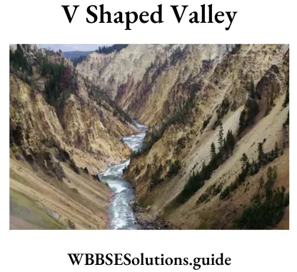
1. V-shaped valley: The valley formed by a river in its upper course in which lateral erosion is greater than vertical erosion is known as a V-shaped valley as it resembles the English alphabet V. This valley is so narrow and the sides are so steep that gorges are formed.
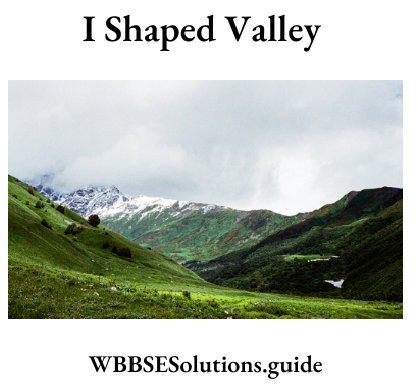
2. l-Shaped valley: The valley formed by a river in its upper course in which vertical erosion is much greater than lateral erosion is known as an l-shaped valley as it resembles the English alphabet T. This valley is very narrow and very deep. It is also called Canyon.
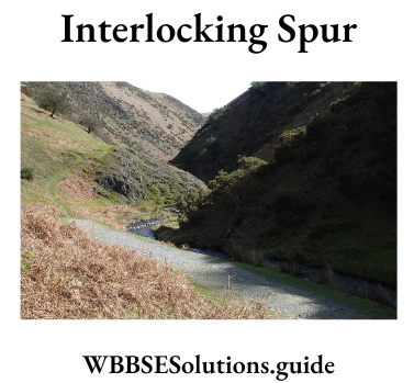
3. Interlocking spur: A series of spurs lies between the banks of the river. As the main channel twists from side to side, so the spurs are described as ‘interlocking’.
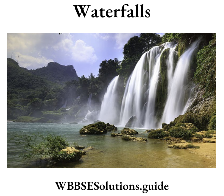
4. Waterfalls: When a stream plunges down a very steep slope over a cliff, it forms a waterfall. India’s highest waterfall, Jog falls, (289.08 m) is on the river Sharavati.
Question 2. Explain the factors responsible for the formation of equatorial low-pressure belt and polar high-pressure belts.
Answer:
Pressure Belts: The atmosphere is immensely heated due to high temperatures. The landmass is heated through insolation and the air close to the surface is heated through conduction. The heated air moves upwards giving place to low pressure.
Thus, a vacuum is created to fill the gap air from a low-temperature area, i.e., air from a high-pressure region comes. Thus, the winds blow from high-pressure areas to low-pressure areas.
1. Equatorial low-pressure belt: All along the equator and between 5° north and 5° south of the equator, a low-pressure belt exists. This is due to
(1) The vertical rays of the sun throughout, intense heat is caused. The hot air rises upwards as convection currents expand,
(2) Presence of a large amount of water vapour makes the air lighter and
(3) rotational force of the earth throws the air from the earth’s surface to make the pressure light. The movement of air is not horizontal but vertical these ascending air are called air currents with very little winds or horizontal movement of air. Thus, the region is known also as the Belt of Calm or Doldrums.
“WBBSE Madhyamik Geography and Environment previous year paper Set 3”
2. Polar High-Pressure Belt: Around the North Pole and South Pole high pressure belts are found due to extreme cold, and very little centrifugal force. Here the region is frozen throughout the year and the temperature is always low.
Question 3. Give an account of the occurrence of orographic rainfall with a suitable example and diagram.
Answer:
Orographic or Relief rain: When clouds on their way dash against hills, plateaus, etc., they rise up. Higher up the clouds condense and then rain falls on the slopes of the mountain and the plateaus. When it goes to the other (opposite) side of the hills, plateaus, etc., it is left with little water vapour.
Therefore, the rainfall is much less on the opposite side. This type of rain is called relief rain as it is caused mainly due to the relief of the land. The opposite side of the hill where the rainfall is much less is called the rain shadow area. The Deccan plateau is an example of a rain-shadow region in India. Orographic or Relief rain.
Question 4. Explain the causes responsible for the development of high tides and ebb.
Answer:
Causes responsible for the development of high tides and ebb
Tides are the periodic rise and fall of the ocean twice in about 24 hrs. Tides are formed because of the following factors
1. Rotation of the earth: The earth is continuously spinning on its axis. This movement causes the development of centrifugal force. Due to the effect of centrifugal force, the water on the earth’s surface has a tendency to move away. This causes high tides to be formed in the seas.
2. Attraction of the earth by the Sun & the Moon: According to Newton’s law of gravity, all objects on the universe attract another object. The attraction of the moon is much more effective because the sun is 380 times further than the moon. Therefore, high and low tides are influenced by lunar attraction.
3. When the moon is directly over the sea, water piles up and causes high tide there. The tides move in a great wave around the earth following the movement, of the moon except where the presence of land stops them. Places on the rotating earth facing the moon experience maximum pull by the moon and enjoy high tide. This is known as Primary tide. Places of the earth opposite to places experiencing primary tides enjoy secondary tides due to the centrifugal force of the earth.
“WBBSE Class 10 Geography and Environment Set 3 practice paper”
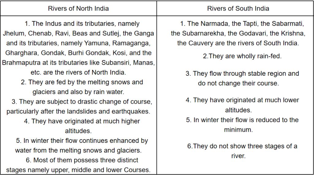
Question 5. State the differences between the physical characteristics of North and South Indian rivers.
Answer:
Differences between the physical characteristics of North and South Indian rivers
Question 6. Give a brief account of the alluvial and black soils of India.
Answer:
1. Alluvial Soil: These soils occupy about 46% of the total land area of the country. Content — The soil is composed of sand, silt, pebbles, and sediments brought down by rivers. The older alluvium or Bhangar soil is mainly composed of clay and contains kankar (lime nodules), pebbles and gravel. The newer alluvium called khadar is mostly sandy.
Characteristics:
1. Colour: These soils are mostly light (pale brown) to dark in colour depending on their time of deposition (young khadar or old bhangra).
2. Texture: Their texture ranges from coarse-grained (upper section) to fine-grained (lower section).
3. Minerals present: Rich in potash and humus but deficient in phosphorous and nitrogen.
4. Crops associated: Alluvial soil is very productive. Wheat, sugarcane, oilseeds, pulses, rice, jute, etc. are grown On this soil.
5. Regional distribution: The soil is found in vast riverine tracts of Sutlej, Ganga and Brahmaputra, in the Northern plains, in the deltas of Godavari, Krishna and Kaveri rivers. The states of Punjab, Haryana, Uttar Pradesh, Bihar, West Bengal, Assam, Odisha and other coastal (Eastern) states have alluvial soil.
2. Black Soil: This soil covers 16.6% of the total land area of India and is also called regur (derived from the Telegu word regular) and black cotton soil. Composition — The soil is composed of basic lava spread during volcanic activity in the Deccan plateau region.
Characteristics:
1. Colour: The soil varies in colour from black to chestnut brown, medium black or even a mixture of red and black.
2. Texture: They are fine-grained with more than 60% of clay.
3. Minerals present: Black soils contain lime, alumina, iron, potash, magnesium carbonates and calcium. They are deficient in phosphate and nitrogen.
4. Crops associated: Because of their high fertility and moisture retentive capacity, crops like cotton wheat, rice, sugarcane, groundnut, tobacco, jowar, fruits and vegetables are grown on it.
5. Regional distribution: They are common in the Deccan Trap region covering Maharashtra, parts of Gujarat, Madhya Pradesh, Andhra Pradesh and Karnataka.
“Madhyamik 2023 Geography and Environment Set 3 question bank”
Question 7. State favourable physical conditions required for cultivation of wheat.
Answer:
The favourable conditions for growing cotton are:
Geographical:
1. Temperature: 23° – 32°C with an average around 27°C.
2. Sunshine: Plenty of sunshine during the growing period and cooler conditions during harvest.
3. Rainfall: 50-80 cm of rainfall well-distributed during the growing period. But rainfall is injurious after the budding period.
4. Frost: At least 200 frost-free days are required.
5. Soil: Black cotton soil or regular soil is the best for cotton.
6. Land: Flat or undulating land with good drainage and no water logging is good for cotton.
Economic:
1. Labour: Much labour is required for planting, thinning of seedlings, hoeing, an inspection of pests, picking of balls, etc.
2. Transport: Good transport system helps in carrying raw cotton to factories and finished products to markets.
3. Fertilisers and pesticides: Cotton is highly soil-exhaustive. Hence fertilisers are necessary to maintain soil fertility. Pesticides are used to control pest attacks.
4. HYV: High yielding variety of seeds like MCU-4, MCU-5, Hybrid-4, Sujata, Varalaxmi, etc. help to raise the yield of cotton per hectare.
Question 8. Discuss the importance of the transportation system in India.
Answer:
Importance of Transportation System:
1. A vast country requires a good network of transport systems to connect one end to another. Travelling even to remote areas is made possible with a developed transport system.
2. Transport system helps to raise the production of raw materials, fuels, machinery, etc. by providing a market to them. A good market demands large-scale production.
3. Well-developed transport system helps in establishing industries in any area. Raw materials, fuels or machinery can be sent at the right time through a well-knit transport network and this helps to run an industry smoothly.
4. A developed transport system facilitates the setting up of industries even in backward areas.
5. The mobility of the labour force increases if there is a good network of transport. Thus they help to solve the problem of unemployment also.
6. By helping to establish industries transport system affects the economic development of a country.
7. Good transport system helps to protect the people from the difficulties of war and natural calamities, as the transfer of military equipment, soldiers or shifting of people evacuated from any area necessitated a well-integrated transport network.
8. Besides all these, the transport system helps to establish relationships among people of different parts of a country and thus strengthen unity and brotherhood among the people.