
Group A Write The Correct Answer From The Given Alternatives:
Question 1. The process by which, the elevation of the earth surface decreases, is called:
1. Volcanic
2. Aggradation
3. Deposition
4. Degradation
Answer: 4. Degradation
Question 2. The highland between two river basins is called:
1. Water divide
2. River terrace
3. Natural levee
4. Doad
Answer: 1. Water divide
Question 3. A lake carved out by glacier is:
1. Corrie lake
2. Playa lake
3. Ox-bow lake
4. Lagoon
Answer: 1. Corrie lake
Question 4. Plain formed by wind deposition is called:
1. Dune
2. Hamada
3. Dhrian
4. Loess
Answer: 4. Loess
Question 5. Lakes containing saline water in the Sahara desert are called:
1. Shotts
2. Balson
3. Dhand
4. Tal
Answer: 1. Shotts
| Class 9 English Bliss | Class 9 Life Science |
| Class 3 English | Class 9 Geography |
| Class 10 Life Science | Class 9 History |
| Class 9 History | Class 9 Maths |
WBBSE Madhyamik Model Question Paper 2023 Geography And Environment Set 5
Question 6. The union territory of Ladakh is separated from:
1. Telangana
2. Jammu & Kashmir
3. Uttarakhand
4. Jharkhand
Answer: 2. Jammu & Kashmir
Question 7. The valley between Siwalik and Lesser Himalaya is called:
1. Bhavan
2. Khadar
3. Karewa
4. Dun
Answer: 4. Dun
Question 8. The largest river valley project of India is:
1. Hirakund
2. Bhakra-Nangal
3. Nagarjun Sagar
4. Rana Pratap Sagar
Answer: 2. Bhakra-Nangal
Question 9. “Burst of Monsoon” is first observed in:
1. Kerala
2. Karnataka
3. Meghalaya
4. West Bengal
Answer: 1. Kerala
Question 10. “Chandan” tree grows in the region of:
1. Tropical evergreen vegetation
2. Tropical deciduous vegetation
3. Tropical desert vegetation
4. Coniferous vegetation
Answer: 2. Tropical deciduous vegetation
Madhyamik 2023 Geography And Environment Model Question Paper
Question 11. The Central Coffee Research Institute of India is located at:
1. Jorhat
2. Bengaluru
3. Chikmagalur
4. Coimbatore
Answer: 3. Chikmagalur
Question 12. The most important center of IT industry in West Bengal is at:
1. Durgapur
2. Kharagpur
3. Sector – V, Salt Lake
4. Siliguri
Answer: 3. Sector – V, Salt Lake
Question 13. According to Indian Census, the minimum population of an urban center is
1. 4000
2. 5000
3. 6000
4. 7000
Answer: 2. 5000
Question 14. The biggest port city of India is:
1. Haldia
2. Chennai
3. Kolkata
4. Mumbai
Answer: 4. Mumbai
Group B If The Statement Is True, Write ‘True’ And If False, Write ‘False’ Against The Following (Answer Any Six Statements):
Question 1. Cusec is the unit used for measuring river velocity.
Answer: False
Question 2. A floating ice mass in the sea is called an iceberg.
Answer: True
Question 3. Sri Lanka is a neighboring country that shares a boundary with India.
Answer: False
Question 4. Aravalli in India is an example of a young fold mountain.
Answer: False
WBBSE Class 10 Geography And Environment Set 5 Model Paper With Answers
Question 5. ogtak is the largest lagoon of India.
Answer: False
Question 6. The “Central Forest Research Institute of India” is located at Dehradun.
Answer: True
Question 7. One of the forest-based industries of India is the paper industry.
Answer: True
Fill In The Blanks With Suitable Words (Answer Any Six):
Question 1. The Nile delta is _______ shaped.
Answer: arcuate
Question 2. The highland between two adjacent corries is called ______.
Answer: Arate
Question 3. the highest mountain peak of South India is _______.
Answer: Anaimudi
Question 4. The Brahmaputra is known as ______ in Arunachal Pradesh.
Answer: Dihang/ Dibang/Seong
Question 5. The dust storms developed during summer seasons in North-West India is known as ______.
Answer: India
Question 6. _______ soil is ideal for the growth of mangrove forests.
Answer: Saline / Coastal / Physiological Desert
Question 7. Jamnagar is famous for ______ industry.
Answer: Oil refining & Petrochemical
Answer In One Or Two Words (Any Six):
Question 1. Which bank of a river meander experiences more erosion?
Answer: Concave slope / Outer bend
Question 2. At which altitude, the snow line is found in polar region?
Answer: sea level / 0 meter
Question 3. Name the sand dunes formed parallel to the wind direction.
Answer: Self-dunes / longitudinal dunes
Question 4. What is ‘Tal’ in Western Himalaya?
Answer: Lakes /Glacial Lake / Water body
Madhyamik Geography And Environment 2023 Set 5 Solved Question Paper
Question 5. In which the State of India, does the lower course of river Ganga lies?
Answer: West Bengal
Question 6. Name a farming technique that prevents soil erosion on the hill slopes.
Answer: Terrace Farming / Contour Farming / Strip Farming
Question 7. Which State of India ranks first in sugarcane production?
Answer: Uttar Pradesh
Question 8. Where was the first cotton mill set up in India?
Answer: Ghusuri (West Bengal)
Match The Left Column With The Right Column:
Left Column Righ Column
Namcha Barwa 1. Rajasthan
Majuli 2. Odisha
Marusthali 3. The peak of Eastern Himalaya
Paradweep 4. Brahmaputra
Answer:
Namcha Barwa : 3. The peak of Eastern Himalaya
Majuli: 4. Brahmaputra
Marusthali: 1. Rajasthan
Paradweep: 2. Odisha
Group C Answer The Following Questions In Brief (Alternatives Should Be Noted):
Question 1. Define “gradation”
Answer:
Gradation
Gradation is the process of leveling of the land by natural agents like rivers, groundwater, winds, glaciers, and sea waves. The processes in gradation are erosion, transportation, and deposition.
Or, What is alluvial cone?
Answer:
Alluvial cone
As the river comes suddenly from its upper course to its middle course, its velocity decreases and its sediments are deposited along with the flow of the river resembling the shape of a cone or fan. This is known as the Alluvial cone.
Question 2. What do you mean by “piedmont glacier”?
Answer:
Piedmont glacier
In temperate regions, the snow line descends quite low. Here small glaciers descend at the foot of the mountains and start meeting with each other. It is called the piedmont glacier.
Or, Define “transverse dune”.
Answer:
Transverse dune
A large, strongly asymmetrical, elongated dune lying at right angles to the prevailing wind direction. Transverse dunes have a gently sloping windward side and a steeply sloping leeward side. They generally form in areas of sparse vegetation and abundant sand.
Question 3. What do you mean by “Maidan”?
Answer: A wide flat land area whose height is generally low. Generally, flat and wide areas up to 150 meters above sea level are called plains.
Madhyamik 2023 Geography And Environment Set 5 Important Questions
Or, What is “Rann of Kutch”?
Answer:
Rann of Kutch
The Rann of Kutch is a salt marsh located in the Thar Desert in the Kutch District of Gujarat. Also referred to as the White Desert, it is about 30,000 sq. km. in size and is reputed to be one of the largest salt deserts in the world.
Question 4. Define “Western Disturbance”.
Answer:
Western Disturbance
During the winter season cyclonic disturbances come from the Mediterranean region. They enter India from the northwest and give some rainfall to the North Western India, Gangetic plains and snowfall in the Himalayan region. These depressions coming from the west disrupt the quiet weather in winter and, therefore, are called Western Disturbances.
Or, What do you mean by “Agro-Forestry”?
Answer:
Agro-Forestry: Agroforestry is a part of social forestry and represents the intermediate stage between forestry and agriculture. Agro-forestry refers to “the sustainable system of managing a piece of land through combined production of agricultural crops and forest crops and animal rearing, to ensure the most efficient land use under a management system in accordance with socio-cultural practices of the local people”. Agro-forestry aims to provide conservation of the land and its improvement in order to achieve a combined production of forest and agricultural crops.
Question 5. Define “Terrace Cultivation”.
Answer:
Terrace Cultivation
Terrace cultivation, is a method of growing crops on the sides of hills or mountains by planting on graduated terraces built into the slope.
Or, What are commercial crops?
Answer:
Commercial crops
In Commercial agriculture, crops that are in high demand, i.e. crops that need to be exported to other countries or are used as raw materials in industries are produced mainly.
Question 6. What do you mean by “pure raw materials”?
Answer:
Pure raw materials
An element that does not change its weight or mass when it is turned into the finished product. It contains no impurities that are burnt off or removed so the weight will remain the same.
Or, What is “North-South Corridor”?
Answer:
North-South Corridor
The National Highway that connects Srinagar in the North to Kanyakumari in the south, via Salem and Cochin, is known as the North-South corridor. This is about 4,000 km long.
Group D Give A Brief Explanatory Answer Of The Following (Alternatives Should Be Noted):
Question 1. Explain why wind erosion dominates in the hot desert regions.
Answer:
Although the wind blows over the whole of the earth, its action is predominant in arid regions. This is because:
1. No obstacle in wind direction: In desert regions, due to lack of rainfall, there is no or very less vegetation cover. Thus wind blows unhindered at high speed.
2. Loose and exposed soil: Lack of vegetation makes the soil loose and exposed to wind action.
3. High diurnal range of temperature: Great difference between day and night temperature causes rocks to crack and break due to contraction and expansion. This makes the work of the wind easier.
Or, State the differences between tributaries and distributaries.
Answer:
The differences between tributaries and distributaries
1. Brahmaputra valley is drained by the river Brahmaputra and its tributaries. The region is prone to earthquakes, so the river is changing its course very often, causing floods,
2. Sometimes river beds are raised because of earthquakes causing floods,
3. The river has taken a zig-zag course. So during rainy seasons, its banks are over-flooded with rainwater,
4. Deposition of silt at the river bed, making the river shallow and causing floods.
WBBSE Madhyamik Geography And Environment Set 5 Multiple Choice Questions
Question 2. Explain briefly three effects of climatic changes observed in the Sundarban region.
Answer:
Effects of climatic changes observed in the Sundarban region
Global warming and climate change compound the dangers to the Sundarbans. These low-lying mangrove forests are highly susceptible to the effects of sea-level rise-including inundation of coastal areas, increased exposure to storm surges, in- creased coastal erosion, and rising salinity in ground and surface waters.
Or, Mention three differences between river valley and glaciated valley.
Answer:
Differences between river valley and glaciated valley
| Basis | River Valley | Glaciated Valley |
| 1. Shape | V-shaped or l-shaped. | U-shaped. |
| 2. Creating an agent | Flowing water of the river. | Sliding ice of the glacier. |
| 3. Process of erosion | Corrasion as well as corrosion. | Abrasion and plucking. |
| 4. Time of predominance | Predominates in the present day. | Predominated in the past during ice ages. |
| 5. Origin and termination | Originates at the end of the glaciers and terminates at the oceans. | Originates at the high mountain slopes and terminates at the mountain bases below the snowline. |
| 6. Superimposition | Now, river valleys are superimposed on the past valleys by glaciers. | During the ice ages, glacial valleys were superimposed on the previous valleys carved out by rivers. |
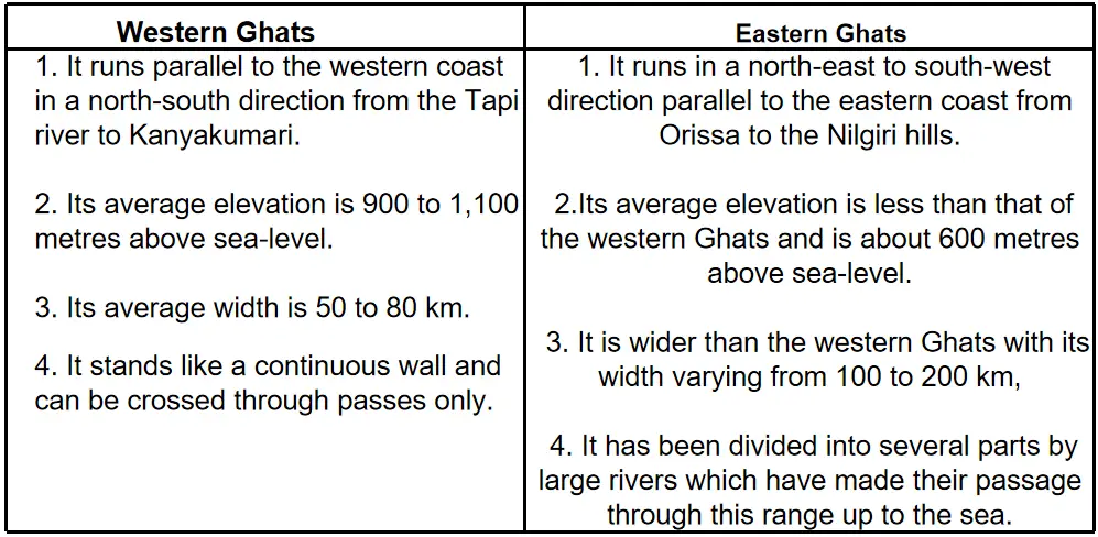
Question 3. Write three differences between the Eastern and Western Ghat mountain ranges.
Answer:
Differences between the Eastern and Western Ghat mountain ranges
Or, Explain why deltas are not formed at the mouth of west flowing rivers of India.
Answer:
The slope of the Western Ghats is steep and that is the reason that these rivers have a rapid flow. They don’t have to travel much distance to drain into the sea. As a result, they don’t carry many sediments required to form deltas.
1. The eastward slope consists of the Deccan plateau. In other words, the western coast is higher when compared to the eastern coast. Thus there is no ground presented for delta-based formation.
2. The west-flowing rivers come from the western ghat. The western coast consists of hard rocks. So it is not possible.
3. The hard rocks don’t allow west-flowing rivers to widen their mouth. Hence they formed estuaries instead of deltas.
WBBSE Madhyamik 2023 Geography And Environment Set 5 Practice Paper
Question 4. Analyse three factors responsible for the development of IT industry in India.
Answer:
Factors for the Growth of It sector in India: This industry has flourished in India because of certain factors:
1. The Government of India has started the ‘Digital India’ project which has given IT a secured position inside and outside India.
2. The IT sector in India is generating 2.5 million direct employment. So, India has become one of the biggest IT capitals of the modern world.
3. Bengaluru is considered to be the Silicon Valley of India because it is the leading IT exporter. Exports dominate the industry and constitute about 77% of total industry revenue.
4. India provides a large domestic market for this industry.
5. The top 5 Indian IT Service Providers are Tata Consultancy Services, Infosys, Cognizant, Wipro and HCL Technologies.
6. The Software Technology Parks of India (STPI) is owned by the government. These parks in different cities provide satellite links to be used by firms.
7. The government also allowed individual companies to have their own dedicated links which allowed work done in India to be transmitted abroad directly.
8. A number of cities in India are developing IT infrastructure and are taking part in software exports.
9. Indian Institute of Information Technology is set up to create a pool of technically literate individuals for its growing industry.
10. High concentration of IT companies and quality research and development institutions throughout India also contribute to its growth.
Or, Why population density is very high in Ganga plain?
Answer:
The Ganga plains of India have a high population density due to many reasons. The northern plains have been densely populated for centuries due to fertile land, availability of water and economic activities. Rivers like Ganga, and Yamuna provide large tracts of fertile land apart from water. Also, the terrain is not a difficult one to travel.
The moderate climate, and fertile land support extensive agriculture. The topography is good for transport and industries. Due to the availability of even fertile land and water, prefer settling in the northern plains as opposed to the desert areas of northwest India.
Group E Answer Any Two Questions From The Following:
Question 1. Describe with sketches three landforms produced by depositional work of river in its middle course.
Answer:
The main features formed by a river in its middle course are
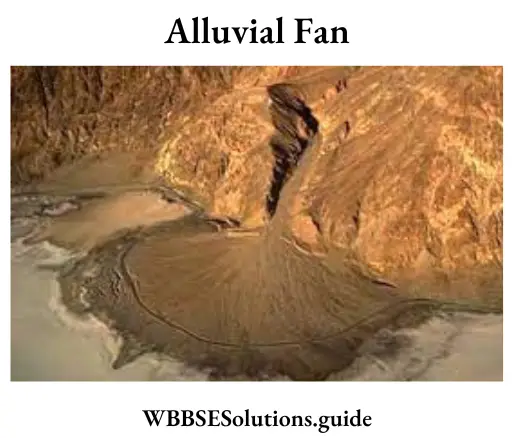
1. Alluvial fan or Alluvial cone: As the river comes suddenly from its upper course to its middle course, its velocity decreases and its sediments are deposited along with the flow of the river resembling the shape of a cone or fan. This is known as Alluvial Fan.
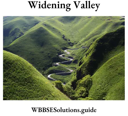
(1)Widening valley: In the middle course of a river, lateral erosion predominates. The volume of water increases and the flow of water exerts its greatest force at the banks.
(2)Sand bars: The pebbles, sand, silt, etc. are deposited on the valley floor to form sand bars. Such bars are very common at the mouth of a river.
(3)Meander: In the middle course of river a because of the slackening of speed, a series of loops and bends are noticed. These bends are called meanders.
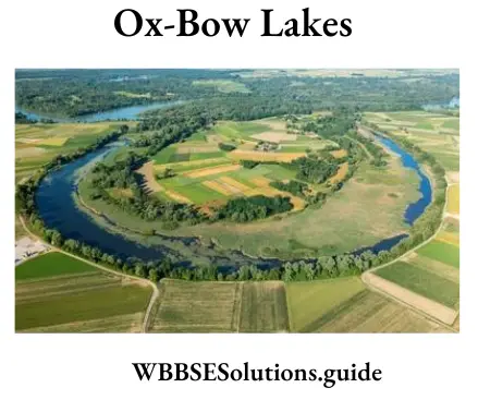
2. Oxbow lakes: During the meandering course of a river it often cuts through the curve to flow straight. Hence the left curve becomes a lake called ox-bow lake or horse-shoelace.
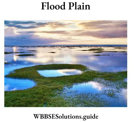
3. Flood plains and Natural levees: During the rainy season flood occurs in the river. So the water spreads out and deposits the sediment brought down and forms flood plains. On the bank of the river repeated deposit of silt or clay increases the height of the bank, forming natural levees.
Madhyamik 2023 Geography And Environment Set 5 Previous Year Question Paper
4. Yazoo streams: During floods, levees may develop across the junctions of minor tributaries. Those tributaries are then compelled to follow a meandering course of their own until they find a new entrance in the main river. They flow roughly parallel to the main river in between the levees. Such rivers are called yazoos.
Question 2. Describe with sketches three features carved out by wind erosion.
Answer:
Features carved out by wind erosion
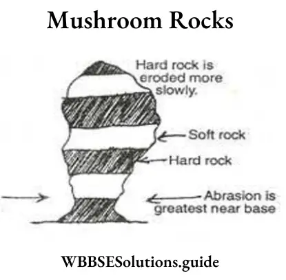
1. Mushroom Rocks Sometimes the degree of hardness in the rocks varies considerably. Due to differential abrasion, the softer rock is worn out more easily than the harder rock and the under-cutting on the base is more than on the top forming narrow rock. The rock resembles the like of an elephant or camel or another animal. Local names are given to this type of rock such as Mushroom rock or Gour.
2. Zeugen When the wind blows steadily in one direction for a considerable time due to differential abrasion, the wind wears away the underlying softer rock through the joints (caused by mechanical weathering). The harder rock layer stands uneroded and stands like ridges. This is known as Zeugen. They are of varying heights (from 1.5 m to 45 m).
3. Yardangs: Yardangs are one of the various landform features developed out of aeolian erosion in desert regions. When hard and soft rocks are arranged vertically on the earth’s surface, then the soft rocks get quickly eroded forming long valleys while the hard rocks stand out as ridges called Yardangs. These are generally 15 metres high and are found in the deserts of Central Asia.
Sometimes hard and soft rocks stand parallel to the prevailing winds. Due to abrasion soft rocks are worn away and the hard one stands as stony ribs. The whole area resembles ‘furrow’ or ‘ridges’. This phenomenon is known as ‘Yardang’. This is common in the Atacama desert.
4. Inselberg: Inselbergs are very highly resistant hard rock structures formed due to wind erosion. They are found in desert areas and are of usually the same height. They have a flat-topped surface with steep slopes.
Question 2. Describe in brief the major characteristic features of Indian climate.
Answer:
Features of Indian Climate:
1. Tropical monsoon type of climate.
2. Diversity in climatic conditions.
3. Monsoon mechanism dominates the climate.
4. Presence of four distinct seasons in the year.
5. Tropical depressions or Bay cyclones in late monsoons.
6. Westerly depressions causing rainfall in winter in North India.
Question 3. Give an account of favourable physical factors required for cultivation of rice in India.
Answer:
Rice is primarily a crop in the Tropics and Subtropics. It requires the following physical conditions for its growth:
1. Climatic conditions: Rice is a crop of the Tropical Monsoon land. It requires a hot and humid climate.
(1)Temperature: It needs a temperature of over 16°C to 20°C for its cultivation. The temperature must be higher during the growing season. It thrives well in plenty of bright sunshine with an average temperature of 27°C and water.
(2)Rainfall: Rice requires abundant rainfall, ranging from 150 cm to 200. cm. Plant of water is necessary at the time of early growth and transplantation. Water should remain standing on the ground up to 5 cm to 10 cm in the rice field in the earlier part of its growing season.
2. Land: Rice requires flooded fields. Extensive plains and lowlands provide excellent conditions for paddy cultivation. On hills and mountains, rice is grown on terraces.
3. Soil: Rice grows on a wide variety of soils, but alluvial loam with subsoils of clay is ideal. Level lands with alluvial soils of the river valleys and deltas are ideal for rice cultivation.
4. Agricultural labour: Rice cultivation requires cheap and abundant labour, as most of the work in rice fields, such as sowing, transplanting and harvesting are done by hand.
5. Other requirements: The other requirements of rice cultivation include
(1)Chemical fertilizer,
(2)Irrigation,
(3)Seeds,
(4)H.Y.V. seeds and
(5)capital.
Question 4. Explain the factors responsible for the concentration of iron and steel industry in Eastern India.
Answer:
Factors responsible for the development of the Iron and Steel Industry: Most of the iron and steel plants of India, such as Jamshedpur, Burnpur, Durgapur, Rourkela, Bhilai and Bokaro are located in Jharkhand, West Bengal, Odisha and Chattisgarh.
The causes for the concentration of iron and steel plants in eastern India are:
1. Iron ore: About 80% of India’s iron ore is available in this region. The major mines are
(1) Noamundi, Guwa, Budaburu, Pansiraburu of Singhbhum district, Jharkhand,
(2) Gurumahishani, Badampahar, Sulaipat and Bonai of Mayurbhanj district and Bagiyaburu of Keonijhar district, Odisha.
2. Coal: About 97% of India’s coal is mined in this region. The steel plants of Kulti, Burnpur, and Durgapur get their coal from the mines in Raniganj and Asansol. The steel plants of Jamshedpur, Bokaro and Rourkela get their coal from Jharia, Bokaro, Ramgarh and Giridih in Jharkhand.
3. Other raw materials: Limestone, dolomite, manganese, etc. are collected from Kalahandi, Gangapur and Kara put of Odisha. Other raw materials like chromium, tungsten, nickel, etc. are easily collected from the Chotanagpur plateau.
4. Water: The rivers Damodar, Mahanandi, Subarnarekha, etc. supply ample water required in the steel plants.
5. Transport: The network of roadways and railways in eastern India help in trade and commerce. The ports at Kolkata, Haldia and Paradweep help in international trade.
6. Power Supply: Thermal power is acquired from Bokaro and Durgapur thermal power plants. Hydel power is acquired from power projects at Hirakud, Myth, Panchet and Tilaiya.