
Physical Divisions Of India And Their Influence On Human Life
The land of India is characterised by great diversity in its physical features. It is diversified in respect of relief, drainage, climate, soil, natural vegetation etc.
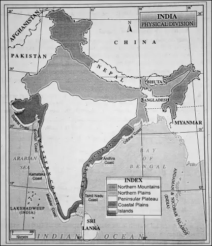
Physiography Of India
Among the physical aspects of the geography of India, physiography or relief refers to the physical features of lofty mountains, vast plateaus, extensive plains, deserts and coastal regions etc.
“WBBSE class 6 physical geography chapter 10 notes”
Physiographic Regions of India :
Physiographically, India can be divided into the following physiographic macro divisions.
Read and Learn More WBBSE Notes For Class 6 Junior School Geography
(1) The Northern Mountainous Region,
(2) North Indian Riverine plains or the Indus-Ganga plain and Brahmaputra valley.
(3) The Peninsular Plateau Region,
(4) The Desert Region of the West,
(5) The Coastal Plains, and
(6) Indian Islands.
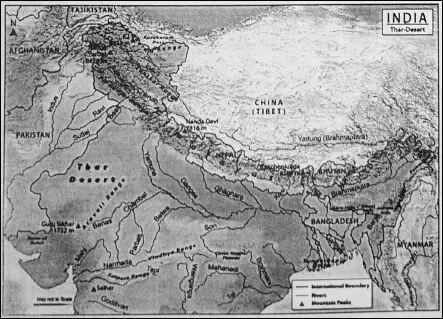
The Northern Mountainous Region
Location and Extent :
The northern mountain region is located to the extreme north of India. It is like a wall extending from Jammu and Kashmir to Arunachal Pradesh. From west to east, its distance is about 2500 km and its width or north to south distance is about 250 km to 400 km.
Major Mountains :
The Northern mountain region comprises :
- The Himalayan mountain range.
- The Karakoram range.
- The Ladakh range .
- The North-Eastern Mountain region or Purvachal.
The Himalayas :
The Himalayan mountain range is the most important mountain range here. It means ‘home of ice’ or ‘abode of snow’. The Himalayas extends from ‘Nanga Parvat’ (8126 m.) in Jammu and Kashmir in the west to ‘Namcha Barwa’ (7755 m.) in Arunachal Pradesh in the east for a distance of about 2500 km and a width of about 250 km to 400 km. The shape of the Himalayas is like an arc.
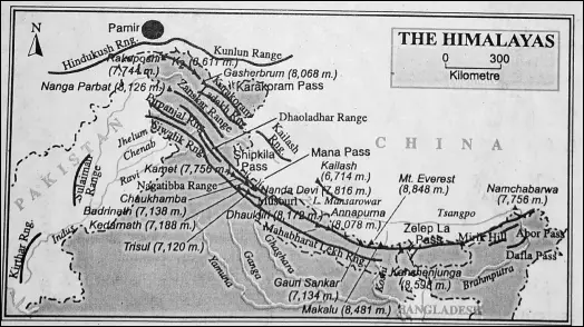
South To North Regional Divisions Of The Himalayas
The Himalayas consist of four parallel ranges from south to north :
- The Siwaliks
- The Lesser Himalayas or Middle (Inner) Himalayas
- The Hlmadri or the Greater Himalayas and
- Trans- Himalayas.
The Siwalik :
The southernmost range of the Himalayas is known as the Siwaliks or the ‘Outer Himalayas’. The average height of the Siwaliks is about 1000 metres-with a width ranging from 15 to 50 km.
“physical geography of India WBBSE class 6 notes”
The Siwaliks consist of the foothills which run -through as the foothills of the Himalayas. They are composed of highly unconsolidated deposits of the Himalayas. They were called ‘Upagiri’ by the ancients. These ranges are discontinuous and are not found in the Eastern Himalayas.
| Class 6 History | Class 6 Social Science |
| Class 6 Geography | Class 6 Science |
| Class 6 Maths | Class 6 Science MCQs |
| Class 6 General Science | Class 6 Maths Solutions |
| Class 6 Geography | Class 6 Hindi |
Doons:
Narrow longitudinal valleys lying in between the Siwaliks or outer Himalayas and the lesser or Inner Himalayas are known as ‘Doons’ or ‘Duns’. These are formed by the deposition of sediments.
“summary of class 6 physical geography chapter 10 WBBSE”
The Duns in the Kumaon Himalayas such as Dehradun, Kothri dam, Patali, Kulu, and Kangra in Uttarakhand and Himachal Pradesh are well known. These beautiful valleys contain fertile soil and they are agriculturally developed and prosperous.
Terai :
The Terai is a marshy/swampy strip of land (with grasslands and forests) located in between the outer foothills of the Himalayas-the Siwaliks and the northern plain of the Ganga, Brahmaputra and their tributaries.
In northern India, the Terai spreads eastwards from the Yamuna river across Uttarakhand, Haryana, Uttar Pradesh and Bihar and southern part of Nepal. Corresponding parts of West Bengal, Bangladesh, Bhutan and part of Assam, east to the Brahmaputra river are called ‘Doors’.
The Naga and Patkoi hills at the eastern border of India and Garo, Khasi and Jayantia hiJIs in Meghalaya belong to the Terai region. The lowlands plains of the Terai lie at an altitude ranging between 67 and 300 metres.
The Middle or Inner Himalayas :
The middle (inner) or lesser Himalayas lies in the north of the Siwaliks and south of the great Himalayas and stretch parallel to them. The average height of this range ranges from 3500 to 4500 metres.
Dhauladhar, Pir-Panjal, Nag Tibba and Mussourie ranges are some of the important ranges here. Among the ancients, they were known as ‘Antagiri’ or ‘Himachal’.
The picturesque hill stations of this region-Shimla, Manali, Nainital, Mussoorie, and Darjeeling are located here and attract tourists from all over the world.
Himadrl or the Great Himalayas :
This range is extending from Nanga Parvat in the west to Namcha Barwa in the east. The Himadri Himalayas comprise all major mountain ranges of the Himalayas. It is the highest part of the Himalayas.
Great Himalayas is the loftiest range because it contains most of the ‘eight thousand peaks’ of the world. The average elevation of the Himadri is about 6000 metres and it is permanently covered with snow.
“important questions from physical geography of India class 6”
Mt. Everest (8848 m), the highest peak of the world is located here. There are some other peaks, such as Kanchenjungha (8598 m), Dhauligiri (8172 m), Nanga Parvat (8126 m), Annapurna (8076 m), Nandadevi (7817 m).
Kanchenjungha is considered as the third-highest mountain peak of the world.
Trans-Himalayas :
The Trans-Himalayas or the Tethys Himalayas consist of ranges like ‘Karakoram’ farthest in the north. The second highest mountain peak of the world Mt. Godwin Austin (8611 m) or ‘King of Karakoram’ (K2) stands here.
It is considered as the highest mountain peak of India. A number of large glaciers are found along the southern face of the Karakoram. It has an average height of 5000 m to 6000 metres. The Himalayas merge with the Tibetan Plateau.
West to East Regional Divisions of the Himalayas :
From the west to the east the Himalayan range can be divided into three sections :
- The Western Himalayas
- The Central Himalayas and
- The Eastern Himalayas.
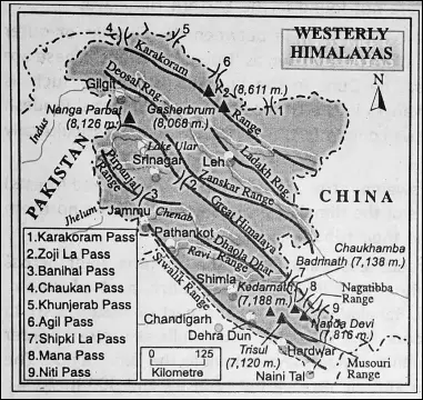
1. The Western Himalayas include the Himalayas of Jammu and Kashmir, Himachal Pradesh, Punjab and Uttarakhand. It is called the ‘Trans-Himalayas or Tethys Himalayas’. They are made up of the Ladakh Range, Zanskar range and the Pir-Panjal Range.
2. The Central Himalayas lies in Nepal.
3. The Eastern Himalayas extends from the Singalila in the west to the Namcha Barwa in the east.
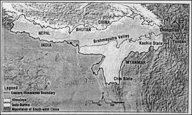
It can be divided into three sub-divisions—
- Sikkim- Darjeeling Himalayas,
- Bhutan Himalayas and
- Arunachal or Assam Himalayas.
Mountain passes :
There are a few mountain passes in the Northern mountain region. Important passes in India and their location are as follows :
Banihal pass (Jawahar Tunnel) and Zojila located in Jammu and Kashmir; Shipkila and Bara Lachala in Himachal Pradesh; Nathula and Jelepla in Sikkim and Bomdila in Arunachal Pradesh.
Glaciers:
A glacier is a large mass of moving ice or a river of ice. There are many glaciers in the Northern mountain region of India. Important glaciers are as follows
Glaciers in the Karakoram Ranges :
- Siachen, the longest glacier in India,
- Baltaro glacier,
- Biafo Glacier etc.
Glaciers in the Himalayan Ranges :
- Gangotri glacier (39 km) Uttarakhand,
- Yamunotri Glacier (30 km) is located in Uttarakhand,
- Zemu Glacier (26 km) is located in Sikkim,
- Milam Glacier (15 km) is located in the northeast of Nandadevi (Uttarakhand).
The Influence Of The Himalayas On The Human Life In India

Establishment of Health-restoring centers:
Several hill stations like Kalimpong, Darjeeling, Dalhousie, Shimla, Almorah, etc. have been developed in the Himalayas. There are numerous other benefits like scenic beauty, tourist-attractive sanatorium, freshwater lakes etc.
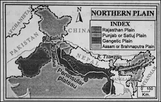
The North Indian Riverine Plains
This plain is also known as the Indus-Ganga Plain and Brahmaputra Valley or as the Great Plain of Northern India.
Location :
This plain is located on the south of the Himalayas and north of the Peninsular Plateau of India, It is extending from Punjab to Assam valleys. It is about 3200 km long and 150 to 300 km wide.
Divisions :
North Indian riverine plains can be divided into three divisions.
These are—
(1) The Punjab Plain drained by the Indus and its tributaries,
(2) The Ganga Plain drained by the Ganga and
(3) The Brahmaputra valley is drained by the Brahmaputra.
Characteristics :
- Although this plain is level and monotonous in nature, some local differences are observed.
- Its average height is about 150 metres.
- It covers an area of 7-5 lakh sq. km.
- It is an alluvium filled through.
- It has been formed by the deposits of sediments brought by the Himalayan rivers (Ganga, Sutlej etc.)
- This plain is the most populous part of India because this region is agriculturally and industrially developed.
Major Rivers Of The North Indian River line Plains
The description of the major rivers, the Ganga, the Brahmaputra and the Indus that form this plain is given below :
The Ganga (2510 km)
The Ganga (Ganges) is an ideal river as well as the longest (2510 km) and principal river of India.
The Course Of The Ganga :
The river rises from the icy cave of Goumukh of Gangotri glacier on the Kumaon Himalaya from the source to the mouth. The river can be divided into three courses-the upper course or mountain course, the middle course or plain course and the lower course or delete course.
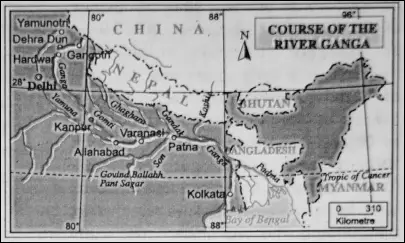
The upper Course :
At the source, the Ganga is known as Bhagirathi. It flows towards the southwest through a narrow gorge and joins the Alkananda near Devaprayag. The combined flow of Bhagirathi and Alakananda is known as ‘Ganga’.
“WBBSE class 6 geography chapter 10 key points”
At Rudraprayag Mandakini rising from ‘Gouri Kund’ joins Ganga. The Ganga flows for about 320 km. in the mountainous region and then comes down to Hardwar. So, the course of Ganga from Goumukh to Hardwar is its upper course or mountainous course.
The middle course :
From Hardwar to Rajmahal hill the river Ganga covers its ‘plain’ or ‘middle’ course. In this course the Yamuna, the largest tributary of the Ganga flows parallel to the river Ganga till its confluence with the Ganga of Allahabad.
The lower course :
From the Rajmahal hill area to the Bay of Bengal the river Ganga covers its lower course. After crossing the Rajmahal hill in Bihar, the Ganga enters in West Bengal.
Near Dhulian in Murshidabad, it is divided into two distributaries-the Padma and the Bhagirathi. The Padma flows towards the southeast and enters into Bangladesh, there it joins the Brahmaputra and Meghna and finally drains into the Bay of Bengal.
The Bhagirathi turns southwards and flows as the ‘Bhagirathi’ at first. Then from Nabadwip in Nadia, it flows up to the mouth of the Bay of Bengal as the name of the ‘Hugh’ river. It merges with the Bay of Bengal forming an estuary and a huge delta.
This delta is famous as ‘the Ganges delta’ or ‘the Ganga-Brahmaputra-Meghna delta. The Ganga basin is the largest part of the northern plains of India.
The soil of this vast plain is the most fertile and it is the major crop-growing area of India. This plan is known as the ‘food bowl of India’.
The Ganges at a Glance
1. Length: 2510 km.
2. Special Features: Largest river of India
3. Major Tributaries : Yamuna, Son, Gomti, Gandak, Kosi etc.
4. Distributaries: Padma and Bhagirathi.
5. Major cities along its course: Hardwar, Kanpur, Allahabad, Benaras, Patna, Kolkata etc
2. The Brahmaputra
Brahmaputra River:
The Brahmaputra is an international river. Since ancient times is it an important river of India Brahmaputra means ‘son of lord Brahma’. The total length of the river is about 2900 km. In India, it is about 885 km. long.
The Course of Brahmaputra :
The Brahmaputra originates in the ‘Chemayundung glacier south-west of ‘Manas Sarovar’ or about 90 km southeast of ‘Rakshas Tal’ in Tibet where it is known as ‘Tsangpo’.
It breaks through the Himalayas in deep gorges near the peak of ‘Namcha Barwa’ in Arunachal Pradesh and bends southward to enter India in the name of ‘Dihang’.
“major physical features of India class 6 geography”
The Dihang, after its union with ‘Dibang’ and ‘Lohit’, gets the name ‘Brahmaputra’ in Assam and flows towards the west (from the east of Sadiya to the west up to Dhubri). The river finally bends southward to meet the ‘Padma’ as the Yamuna river and finally drains into the Bay of Bengal forming a great delta in its mouth.
It is known for its notorious floods and sand deposits. The Brahmaputra flows slowly over the Assam valley due to the gentle slope of the land.
Thus the river flows through pronounced meanders and has many sandbanks and sand bars (Island/char) along its channel. The largest river island in the world lies in this river and is called ‘Majuli’.
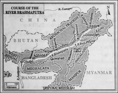
Frequent earthquakes in the Assam valley has caused the Brahmaputra to change its course quite often. The Brahmaputra is known as the ‘Red River of India’ because the water of this river looks reddish in colour especially during floods after mixing with the red soil of Assam.
The important right bank tributaries of the Brahmaputra are Subarnashree, Barali, Manas, Sankosh, North Dhansiri (Dhanashree) and Tista. Itanangar, Nowgaon, Tejpur, Guwahati, Digboi and Dibrugarh are few of the major cities on the bank of river Brahmaputra in India.
Brahmaputra valley is drained by the river Brahmaputra and its tributaries. Most of the these rivers are rainfed as well as snow-fed. During the rainy season due to heavy rainfall the rivers overflow their banks and floods occur several times.
The Brahmaputra at a glance
1. Length: 2900 km.
2. Another name: Tsangpo in Tibet., Yamuna in Bangladesh.
3. Tributaries: Dibang, Lohit, Manas, Dhanashree, Subarnashree, Tista, Torsha etc.
4. Major cities along its course: Itanagar, Dibrugarh, Guwahati etc.
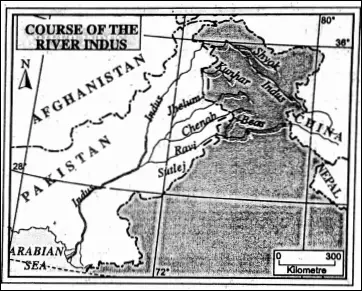
(3) The River Indus :
The river Indus is a very important river in north-western India. It has a length of about 2880 km. but only 709 km is in India. According to one view, the Indus rises from the ‘Sengge Khabab’ glacier or spring at an altitude of 5180 metres of the Kailash range in the southwest Tibetan plateau.
Another view states that it rises from the ‘Manas Sarovar’ lake located on the northern slopes of the Kailash range, in Tibet. Both areas are close together.
Indus at a Glance
1. Length: 2880 Km.
2. Tributaries: Bitasta, Chandrabhaga, Bipasha, Iravati, Shatadru.
3. Flows through Himachal Pradesh and Jammu and Kashmir.
4. Major cities along its course: Led, Srinagar
The course of Indus :
From the source it flows northwest through Tibet and Jammu-Kashmir between the Karakoram and Ladakh ranges covering a distance of about 250 km. Near Nanga Parvat peak it turns around the mountain in deep gorges, to flow southwest wards into Pakistan, and ultimately it drains into the Arabian Sea.
It is Pakistan’s longest river. Among the right bank tributaries of the Indus as its upper course, the Shyok and Shigar are notable. The Zanskar, Dras, and Astor are its left bank tributaries.
The mighty five tributaries of the Indus are the Sutlej (Shatadru), the Beas (Bipasha), the Ravi (Irabati), the Chenab (Chandrabhaga) and the Jhelum (Bitasta). They are collectively known as ‘Panchanad’. The name of Punjab is derived from these five rivers of the Plain.
The Rivers of the Deccan Plateau :
| Name of Rivers | Source | Direction of Flow | The mouth of the River |
| Mahanadl | Sihawa range in Dandakaranya highland. | East | Bay of Bengal |
| Godavari | Trimbak Highland (hills) of Sahyadrl near Nasik. | East | Bay of Bengal |
| Krishna’ | Mahabaleswar in Western Ghats. | East | Bay of Bengal |
| Kaveri | Brahmagirl In Karnataka | East | Bay of Bengal |
| Narmada | Amarkantak peak of the Mahakala range of Madhya Pradesh | West | Gulf of Khambat |
| Tapi (Tapti) | The Mahadev Mountain range. | West | Gulf of Khambat |
The Peninsular Plateau Region
The Great Peninsular Plateau of India is the oldest structure of India. Geologically, it is a part of the ancient landmass of the world, the ‘Gondwanaland’. The Peninsular plateau lies to the south of the Northern Plains of India.
It is a region more or less triangular in shape. It is bounded by the Aravalli range in the northwest and Rajmahal in the northeast. In the northeast, the plateau extends into the Meghalaya Plateau. This plateau is a tilted plateau in nature.
“Himalayan mountain ranges and their importance WBBSE”
The plateau slopes from west to east. The region is mainly composed of ancient granite and gneiss rock. The north-western portion of the plateau is composed of ancient granite (basalt rock).
The prolonged denudation has changed the plateau into dissected plateaus and peneplains at some places. Different residual ranges like Mahakal, Western ghats, Eastern ghats etc. are found here.
Based on variation in landform, this plateau may be divided into three regions-
- The Central Highland
- The Eastern Highland and
- The Deccan Plateau.
The Central and Eastern Highlands of India :
The Central Highland:
The Central Highlands covers the highlands of Rajasthan, Madhya Pradesh, and Uttar Pradesh. It extends from Aravalli in the west and Rajmahal in the east. The southern boundary is limited by the Vindhyas, Satpuras, Mahadev, and Mahakal Raimur range.
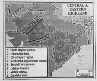
The Aravallis
On the Western border of Central Highland stands the Aravalli, the oldest fold mountain of India as well as the world. Guru Shikhar (1722 km) is the highest peak of Aravalli.
The ‘Vindhyas’ is the most important range of this highland has an average elevation of 300 meters and is the source of the river ‘Chambal’. To the west of the Vindhyas is located the ‘Malwa Plateau’.
The northeastern part of the Malwa Plateau is composed of pink granite and is known as the ‘Bundelkhand Plateau’. The eastern part of the Vindhya range is known as the ‘Rewa Plateau’. The Narmada valley in the south, the Chambal valley, and the Son valley in the north form a typical landscape.
The Eastern Highlands
The Eastern Highlands comprises Chhotonagpur, Chhattisgarh, and Mahanadi Basin. and the plateau of Chhattisgarh and Dandakaranya of Odisha. This highland is dominated by the Chhotonagpur plateau.
‘Pat’ region, the Pareshnath hill (1366 m.) is the highest point in this region. The famous ‘Ranchi Plateau dissected by the river Damodar lies the Hazaribagh Plateau where stands the ‘Pareshnath Hill’.
“northern plains of India class 6 notes”
The Rajmahal hills form the north-eastern boundary of this region. South of the Ranchi Plateau lies the Garhjat hill region.
The Deccan Plateau
The Deccan Plateau is the largest plateau of India. It extends from the Vindhya range in the north to the Kanyakumari (Cape Camorin) in the south.
It is surrounded by mountain ranges on three sides-VVestern Ghats or Sahyadri on the west, Eastern Ghats or Malayadri on the east, and Satpuras and Vindhyas on the north. Deccan Plateau is a tilted plateau with a general eastward slope.
It covers an area of 70 lakh sq. km. Its average height varies between 500 m to 1000 meters. The plateau is a part of the ancient Gondwanaland of the world. It is composed of ancient igneous rocks like granite, basalt, etc. And metamorphic rocks like gneiss. The Deccan Plateau comprises the following physiographic divisions.
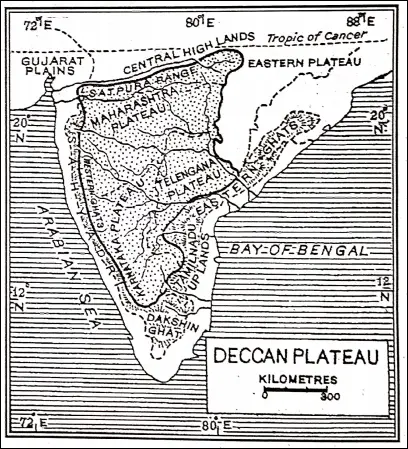
Western Ghats
Western Ghats extend from Tapi (Tapti) valley up to Kanyakumari for about 1500 km. It has three passes-Thal Ghat, Bhorghat, and Palghat. These range abruptly from the coast.
Short swift streams flow towards the west and do not form deltas. The average height is about 1200 meters. Godavari, Krishna, and Kaveri rivers rise from the Western Ghats and flow towards the east.
Maharashtra Plateau
The north-western part of the Deccan Plateau is known as Maharashtra Plateau. It is formed of lava (basalt) rocks lying in a series of steps. Hence, it is called Lava Plateau. It is also known as the ‘Deccan Trap’ (Swedish ‘trap’ means ‘steps’). Erosion of the basalt rock over a long period of time has produced rich black soil (Regur).
Karnataka Plateau
Further south of Deccan Trap is the Karnataka Plateau. The 600 meters contour line may be taken as the boundary of the Karnataka Plateau. The plateau meets the Western Ghats in the west and Eastern Ghats in the east.
Physiographically the plateau can be divided into two parts—
(1) Hilly ‘Malnad’ region in the west and
(2) Flat ‘Maidan’ region in the east.
Telangana Plateau
The Telangana plateau is a rolling surfaced plateau with intervening shallow depression. It is in former Andhra Pradesh (Now it is included in the newest Indian state ‘Telengana’.)
“Indian plateaus and their geographical significance”
The Desert Region In The West
The south-Western part of the plains of Northern India is known as the Rajasthan plain. It lies in the west of the Aravalli range. It enters into Pakistan. The plan is extensively sandy plain. This arid and barren plain is regarded as a desert.
Different types of sand dunes are found in the western portion of this plain. This desert region is known as the ‘Thar Desert’. The Thar Desert is also known as the ‘Great Indian Desert.
Characteristic Features of the Great Indian Desert :
The western portion of Rajasthan which is generally regarded as the “Great Indian Desert” or Thar. The important features of this region are as follows :
1. Thar desert is a part of the Rajasthan Plain.
2. To the east it rises to 325 m and the west it falls to 150 m.
3. Barkhans, seif dunes, etc. are found in this region.
4. The main characteristic features of this region are extremes of climate and extensive sandy plains.
5. Mobile sand dunes of this region are known as “Dhrians”.
6. Dry lakes or almost dry lakes are also found in this region. These saline lakes are called locally as “Dhands” viz. Panch Padra, Didwana etc.
7. The region slopes to the west into the Indus valley and to the south in the Rann of Kachchh.
8. The average annual rainfall is only 25 cm. So, the rainfall is very low here.
9. Very little vegetation are grown here. Patches of thorny bush and grass are found in certain areas.
10. In summer the temperature rises up to 50°C and in winter it drops to 5°C.
11. Short inland drainage basins and water lakes are seen here. Luni is an important inland river and Lake “Sambar” is a typical example of salt water lake on the desert.
12. Population here is very sparse due to the lack of cultivable land, transport, and communication in this area.
Causes Of Origin Of Indian Desert In The Thar Desert
- There is very little summer rain, less than 25 cm annually.
- Humidity is very low in summer. Before it even in rains the moisture has evaporated. Besides, Thar lacks water sources.
- Thar, situated in Western Rajasthan, is a comparatively low-lying region with the Aravallis lying parallel to it.
- The parallel situation of the Aravalli range with the direction of the southwestern Monsoon does not help precipitation. So rainfall received by this region is very scanty.
- The vast region of Western Rajasthan is mainly covered by sand deposited by the wind.
- The Tropic of Cancer is passing through this region. So the temperature is very high and because of the high temperature, the raindrops are turned into water vapor when it falls on the sandy surface.
The Coastal Plains :
The Deccan plateau Is fringed with coastal plains. These plains are washed by the Arabian sea on the west and the Bay of Bengal on the east. The coastal plain have two physiographic divisions. The Western Coastal Plains on the west and the Eastern Coastal Plains on the east.
1. The Western Coastal Plains :
The Western Coastal plains lying between the Western Ghat, and the Arabian sea are stretching from Kachchh in the north to
Kanyakumari to the south.
2. The Eastern Coastal Plains :
The Eastern Coastal Plains extends from the mouth of Subarnarekha river (Odisha) in the north to Kanyakumari in the south.
Sub-Divisions Of The Western Coastal Plains
The sub-divisions of this narrow coastal plain are—
1. The coastal plain of Gujarat (Northern Part). The coastal plain of Gujarat is wide consisting of Kachchh and Kathiawar Peninsulas. The Kachchh region forms marshes and are called ‘Rann’.
The northern section is known as the ‘Great Rann of Kachchh (Kutch)’ and the south-eastern section is the ‘Little Rann of Kachchh (Kutch)’. This large salt marsh is a barren rocky region.
It gets flooded during the rainy season when the sea level rises. It is considered a part of the Thar desert.
2. The Konkan Coastal Plain :
The Konkan Coastal Plain from Daman in the north to Goa in the south is narrow and broken rocky coast.
3. The Karnataka Coastal Plain :
It is stretching from Goa in the north to Mangalore in the south is wider with sand dunes and marshy lands.
4. The Malabar Coastal Plain :
The Malabar Coastal Plain of Kerala is the extreme southern part of the western coastal plain. It is 95 km wide. There are many sand dunes (locally called ‘Theris’) and ‘Kayals’ (backwaters) like ‘Vembanad’ near Kochi (80 km long) and ‘Austamudi’ near Quilon (Kollam).
The Eastern Coastal Plains
the mouth of the river Subarnarekha in the north to Kanyakumari in the south for nearly 1500 km.
It may be sub-divided into two divisions,
- Northern Circars coast and
- Coromandel coast
Northern Circars coast :
Northern Circars coast to the north of the river Krishna including Odisha coastal plains in between the Subarnarekba in the north and the river ‘Rushikulya’ in the south and Andhra Coastal Plain from mouth of Rushikulya to the lake Pulicat.
Coromandel coast :
Coromandel coast stretches from the south Krishna delta to Kanyakumari. This coastal plain is also known as the ‘Tamil Nadu Coastal Plain’. There are many sand dunes and lagoons in the Eastern Coastal Plain.
The sand dunes along the coast of Tirunelveli and Mahabalipuram rise from 30 m to 65 m high. A few lagoons, namely ‘Chilka’ in the Odisha coast, ‘Kolleru’ and ‘Pulicat’ in the Andhra Pradesh coast are found.
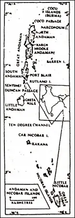
Indian islands :
Indian islands on the Bay of Bengal and the Arabian Sea present an interesting aspect of Indian physiography.
They are divided into two sub-divisions—
- Andaman and Nicobar islands on the Bay of Bengal and Lakshadweep on the Arabian sea.
Islands Of Bay of Bengal Inculding Andaman And Nicobar islands
These are actually the elevated tops of the submerged mountain ranges. These islands of the Andaman group extend between 10°N and 14°N latitudes for a distance of 500 km. These islands are 214 in number.
“coastal regions of India WBBSE class 6 geography”
The Nicobar group consists of 15 islands extending between 6°N to 10°N latitudes. ‘Ten degrees Channel’ separates to the Andaman group islands from the Nicobar group. These islands form a ‘Union Territory’ of India with Port Blair as its capital.
‘Indira Point’ in Nicobar island is the southernmost point of the Indian Union. These islands form the summit of the submerged hills of the sea/ ocean floor. Barren islands and Narcondum islands situated in the north of Port Blair are volcanic islands.
Lakshadweep Islands
These islands are situated in the Arabian sea and lie 320 km off the coast of Kerala between- 8° N and 12° N latitudes. These are coral islands and some of these are ring-shaped and called ‘atolls’. These are 27 in number and 17 of these are uninhabited. It is a union territory with Kavarattl as the capital.
WBBSE Notes for Class 6 Junior School Geography
- Chapter 1 The Universe and Solar System
- Chapter 2 Shape of The Earth: Is The Earth Around?
- Chapter 3 Location of a Place on The Earth’ Surface: Where You Are
- Chapter 4 The Earth’s Motion: The Earth Rotation
- Chapter 5 Water – Land – Air
- Chapter 6 The Ice Capped Continent: Antartica
- Chapter 7 Weather And Climate
- Chapter 8 Air Pollution
- Chapter 9 Noise Pollution
- Chapter 10 India