
Chapter 7 Weather And Climate Introduction
Weather:
Weather is a major determinant in our daily life. If we explain the atmospheric condition of a day for a certain place then we can actually understand the weather of that place.
By weather, therefore, we mean the atmospheric condition of a particular place for a definite time. It is an hour-to-hour or day-to-day condition of the atmosphere at any place with reference to air temperature, air pressure, wind direction and conditions, humidity, cloudiness and precipitation (rainfall).
“WBBSE class 6 physical geography chapter 7 notes”
Weather can vary from time to time and from place to place. Basic knowledge of the weather is useful for all of us. The climate is an average atmospheric condition over a large area for a long period of time (30 to 40 years, say at least an average of 35 years).
| Class 6 History | Class 6 Social Science |
| Class 6 Geography | Class 6 Science |
| Class 6 Maths | Class 6 Science MCQs |
| Class 6 General Science | Class 6 Maths Solutions |
| Class 6 Geography | Class 6 Hindi |
The climate is also the most determining factor of the environment. Climate directly or indirectly affects the different human activities in his daily life.
Weather
Weather is the atmospheric condition in terms of air temperature, pressure, wind, humidity, cloudiness or cloud condition and precipitation of a particular place at a definite time. It may change even with each moment.
Read and Learn More WBBSE Notes For Class 6 Junior School Geography
Climate
The climate is the average of weather conditions of a vast area over a long period of time, at least an average of 35 years.
The differences between weather and climate
| Weather | Climate |
| 1. Weather is the day-to-day condition that depends on atmospheric elements. | 1. Climate is the generalised pattern of weather conditions. |
| 2. Weather changes quickly even in each hour. | 2. Climate remains the same year after year. |
| 3. Weather explains the atmospheric condition of a small area. | 3. Climate describes the average weather conditions of a vast region. |
| 4. Different types of weather may occur at one place. | 4. A particular place cannot have all types of climate. |
| 5. The weather refers to a particular place. | 5. The climate refers to a particular region. |
| 6. The weather is uncertain and changes after a short while, we can only forecast for a short time. | 6. The climate is not uncertain. It has a high degree of accuracy. It remains similar year after year. |
Influence Of The Weather And Climate On Our Lives
Weather is a major determinant in our lives. Our dress, our food and even one kind of shelter depends on the weather of the place we live in. Our ability of work also depends on the weather.
Our health and mentality depend on the weather condition of that particular day. The climate is the most determining factor of the environment. Climate directly or indirectly affects the different activities of man.
The climate also determines our food, clothing, shelter and general mode of life. The food habits of the people vary from season to season and from region to region. Type of clothing varies according to the changes in the weather and climate.
“weather and climate WBBSE class 6 geography notes”
Man builds his house to suit the various elements of weather and climate such as temperature, rainfall etc. Climate determines the growth of crops in a region.
Climate affects our mental alertness, physical characteristics and racial differences. Climate influences the location of industries also. Thus it can be concluded that weather and climate both has a direct and indirect influence on human activities/civilization’s arid mode of life.
Major Elements Of Weather And Climate
Atmospheric conditions on which weather and climate depend are called the elements of weather and climate. These are—
- Air temperature
- Air pressure
- Wind
- Humidity
- Cloudiness or cloud condition and
- Precipitation or Rainfall.
Air Temperature
The air becomes hot by the rays of the Sun. Temperature is the amount of heat received by a place on the Earth. So, the warmth of the air is known as ‘Air Temperature.
“summary of class 6 physical geography chapter 7 WBBSE”
Example: The temperature of Kolkata indicates air temperature of Kolkata. The Sun is the main source of air temperature. It is an important element of weather and climate. It controls the atmospheric conditions of a place and influences the other elements.
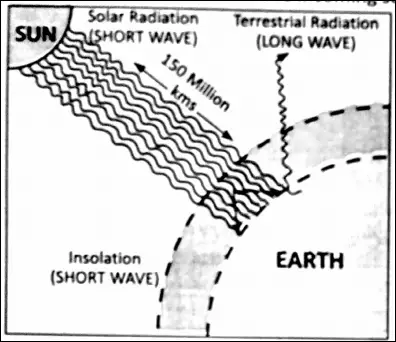
Insulation
Solar radiation as received by the Earth is called insolation. A very small part 1/200,0000000 0f SUn’S energy that reaches the Earth is known as ‘Insolation.
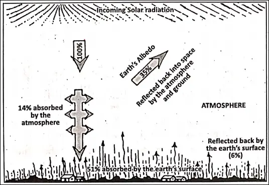
The Earth’s surface is heated by this energy. Only 51% of the insolation heats up the Earth’s surface. So, it is called ‘Effective Solar Radiation.
Albedo
The 35% of the incoming solar radiation (insolation) that it reflected back to space it lost to the atmosphere and it is known as the Earth’s albedo’. The residual 14% it absorbed by the different gases, water vapour and dust particles in the atmosphere.
Terrestrial Radiation
The heat that reaches the Earth’s surface (51%) it almost entirely reflected back to space during the nighttime. This it known as ‘Terrestrial Radiation’. 34% of it is absorbed by the atmosphere and 17% is bounced back to Space.
Terrestrial Heat Balance
The average annual temperature of the Earth as a whole remains almost constant. It has been possible because of the balance between the amount of incoming solar radiation and the amount of terrestrial radiation returned to space.

This balance of incoming and outgoing radiation has been termed as the ‘terrestrial heat balance’ or ‘heat balance of the Earth’ or ‘Earth’s heat budget’.
The different processes of heating up of the atmosphere
The main source of atmospheric heat is the Sun. The atmosphere is not heated directly by the Sun through short-wave radiation. It is indirectly heated by long-wave radiation from the Earth below.
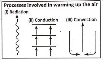
The following processes are mainly involved in heating the atmosphere.
1. Radiation
The heat energy from the Sun is transferred to the Earth by radiation. Radiation is the direct heating of an object or a body by the transmission of heat waves.
This is the only mechanism in which heat can travel through the relative emptiness of space. Hence, the vast amount of energy coming to and leaving the Earth are in this form.
2. Conduction
Conduction is a method in which the heat is transferred by contact between two bodies. When two bodies of unequal temperature are in contact with one another, there is a flow of energy from the warmer to cooler body. This transfer of heat through matter by molecular activity is called conduction.
3. Convection
The transfer of heat by the movement of a mass or substance from one place to another is called convection. Convective motions are possible only in liquids and gases. Conventional current moves vertically to begin with and later on may move horizontally or even downwards as the particles lose heat on their way.
Convection is the most important process of heating the atmosphere. A cyclic circulation of convection currents helps in distributing the heat of lower layers to upper layers.
Advection
The process of horizontal transfer of heat by winds from a hotter to colder region is known as ‘advection’.
Direct absorption
The atmosphere directly absorbs only 14% of the insolation.
The difference in temperature between day and night
Generally, days are very hot and nights are cold. The difference between the highest and lowest temperature in a day at a place is known as the ‘diurnal range of temperature’ or ‘daily range of temperature’.
Daily range of temperature = Daily maximum temperature – Daily minimum temperature. When the diurnal range temperature is high, days are usually hot and nights are cold.
“important questions from weather and climate class 6”
Again the difference between the average temperatures of the hottest and the coldest months is called the ‘annual range of temperature/ Annual range of temperature is calculated as follows :
The average temperature of the hottest month (May) – Average temperature of the coldest month (November). When the annual range of temperature is high, the summers are scorching hot and the winters are very cold.
Measurement Of Temperature
Thermometer:
The common instrument used for measuring temperature is called a Thermometer’. For measuring the temperature of human body we use a ‘Doctor’s or ‘Clinical’ thermometer.
This thermometer is concerned with a very specific and small range of temperature (from 35°C to 45°C or 95°F to 110°F only). Both the Celcius and Fahrenheit scales of temperature have the same common points of reference.
They are the ‘freezing point’ of Water and its ‘boiling point’. The freezing point is the temperature at which water freezes into ice. The boiling point is the temperature at which water boils and turns into water vapour.
The values assigned in the Celcius scale are simple and straight forward namely 0°C for the freezing point and 100°C for the boiling point. In the Fahrenheit scale these values are 32°F for the freezing point and 212°F for the boiling point.
Six’s Thermometer
A special thermometer used to measure the maximum and minimum temperature is Six’s thermometer. This thermometer was invented by James Six in 1782.
This thermometer consists of a cylindrical glass bulb joined in a ‘U-shaped glass tube. The mercury enclosed in the glass tube expands when the temperature rises.
It records the maximum and minimum temperature of the day. Two types of scales, celsius and Fahrenheit for measuring air temperature are used in this thermometer. Both the maximum and minimum temperature of a day can be measured by the same instrument.

Factors Influencing The Variation Of Temperature
The air temperature is not uniformly distributed over the Earth’s surface. It varies from place to place and time to time due to the following causes :
Insolation
Solar radiation as received by the Earth is called ‘Insolation’. The Earth intercepts only one part out of two billion (1/200,0000000) parts of the solar energy radiated.
The amount of insolation reaching the Earth’s surface and its effectiveness per unit area depends upon—
- The angle of incidence or the inclination of the Sun’s rays;
- The duration of sunshine or the length of the day; and
- Transparency of the atmosphere.
All of these are not equal to on the Earth’s surface. So, the temperature is different in different parts of the world.
Latitude
Due to the spherical shape of the Earth, the angle of incidence of Sun’s rays is not the same everywhere on the surface of the Earth When the Sun s rays are vertical over the Equator, they are at an angle of 0* to 90′ at the two poles Vertical rays of the Sun heat on a small area and this leads to the higher temperature.
“WBBSE class 6 geography chapter 7 key points”
Slanting / oblique rays spread the heat over a large area and produce a lower temperature The spherical shape of the Earth and its revolution around the Sun result in a gradual decrease of temperature with an increase of latitude.

On the other hand, vertical rays travel through a shorter distance in the dense atmosphere. Hence, the heat received per unit area is large. Slanting or oblique rays travel through a longer distance m the atmosphere where much of its heat is absorbed by clouds, water vapour and dust particles.
The equatorial region gets maximum temperature as the Sun’s rays fall vertically over the Equator throughout the year In polar regions, the low temperatures are found due to more oblique or slanting rays for example, Chennai (13*N) is warmer than Kolkata (22’30’N) because Chennai is nearer to the Equator than Kolkata.
Altitude
The temperature decreases with increasing height above sea level. The temperature decreases at the rate of 6 4″C or 6 S’C for every 1000 metres or 1 km The main causes for the decrease in temperature with increasing height are as follows
- The lower atmosphere (or layers of air) is denser than the upper layers of air because lower layer of air has many dust particles and it absorbs a larger amount of temperature
- The upper atmosphere is thinner because the density of air is low at higher elevations It cannot hold much temperature.
- Air pressure is low at higher elevations.
- The atmosphere is mainly heated by terrestrial radiation. Therefore, the lower layers nearer the Earth’s surface are warmer than higher layers of the atmosphere.
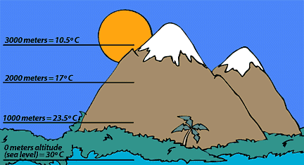
For this reason, the lofty mountain peaks are snow-capped and the mountains are cooler than the plains. For example, as Darjeeling is on the mountain, it gets a cooler climate and as Siliguri is on the plain, it experiences a warmer climate.
Heat Zones of the Earth
Our Earth is like a sphere and sun rays do not fall perpendicularly or vertically everywhere on its surface. Therefore, the distribution of heat is not uniform on the surface of the Earth.
It goes on decreasing from the Equator to the poles. As such different heat belts or temperature belts or zones are found on the surface of the Earth. Based on the variation of temperature over Earth’s surface may be divided into the following heat belts from the Equator towards the poles :
- The Torrid belt or zone.
- The Northern Temperate belt.
- The Southern Temperate belt.
- The Northern Frigid belt and
- The Southern Frigid belt.
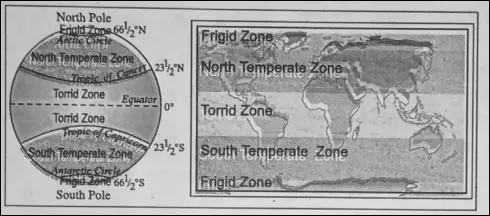
1. The Torrid or the Tropical Zone
The Torrid or Hot Belt or Zone (ies between the Tropic of Cancer (231/z°N) and the Tropic of Capricorn (23%°S). It is the hottest zone of Earth.
The Sunrays fall vertically or near vertically here and the temperature is very high about 25°C to 35°C on an average. There is a near absence of winters because the coldest month has an average temperature of over 20°C.
Variation in the length of day and night is minimum. The annual average temperature is 27°C. The isotherm 27°C is considered the northern limit of the Torrid zone. Places located between 30°N and 30°S are included in this zone.
The Temperate Zone (The Northern and Southern Temperate Zone)
The Northern temperate zone or Belt is located between the Tropic of Cancer (23>20N) and ‘The Arctic Circle’ (661/4°N), while the southern temperate zone is located between the Tropic of Capricorn (2334°S) and ‘The antarctic circle (66H°S).
Sunrays fall over these regions obviously. This is the belt of moderate temperature (10°C to 20°C). The length of the day and night is medium. Temperate belts have remarkable seasonal contrasts in temperatures, one season usually being warm or hot and the other cool or cold.
The summers are not very hot, and the winters are not very cold. The temperate zones of both the hemispheres can be divided into two parts :
- Warm temperate zone (region close to the torrid zone, 30° to 45° latitudes) and
- Cool temperate zone (region close to the Frigid zone, 45° to 60° latitudes).’
The Northern and the Southern Frigid zone or Cold zone
Regions beyond the Arctic circles and Antarctic circles are known as Frigid zones. The Northern Frigid zone lies between the Arctic Circle (661/J°N) and the North pole (90°N).
The Southern Frigid zone lies between the Antarctic circle (6634°S) and the South Pole (90°S). In these zones temperature is constantly low throughout the year because of slanting rays of the Sun.
These are the coldest part of the Earth with mean temperature below 10°C. Snowfall occurs most of the year and land remains frozen.
Isotherms
‘Isotherms’ is a combination of two words ‘iso’=’Equal’. ‘therm’ = ‘Temperature’. Isotherm is an imaginary line (drawn on a map) joining the places of equal temperature reduced to the mean sea level.
The temperature is reduced to sea level to eliminate the effects of altitude. Isotherms, thus, will show the distribution of temperature as if the whole Earth were a level plain.

If a place is 1650 mts in height and its actual temperature is 20°C, its temperature reduced to sea level will be (20°C + 10°C = 30°C) because the temperature decreases at the rate of 1°C for every 165 metres.
Main characteristics
Isotherms never touch or intersect each other.
Difference of temperatures is more between two places, the isotherms are closely spaced and if the difference is less, isotherms are spaced far apart.
- Isotherms run east-west generally following the parallels of latitudes.
- Isotherms take sudden bends where land-water contrasts are maximum.
- Since there are more water bodies in the Southern hemisphere, the isotherms in this hemisphere are situated further away from each other compare to the Northern hemisphere.
- During the summer, isotherms bend towards the equator on the oceans. During the winter, the isotherms bend towards the poles.
Air Pressure
Air is made up of a number of mixed gases and it has weight. The weight of a column of air above a given place determines the ‘air pressure’ at that place. It is also known as ‘atmospheric pressure’.
Air exerts pressure from all directions but we do not feel this pressure because our body’s internal pressure is equal to that exerted by the atmosphere. Air pressure is not the same at all places on the Earth.
“difference between weather and climate class 6”
The air pressure is maximum at the sea level. Normally, the pressure of air at the sea level is 76 cm but it decreases at the rate of 1 cm for every 110 metres of ascent.
The normal or standard air pressure at sea level is 1013.25 mb (millibar). The unit of force to measure air pressure is called a ‘bar’. A ‘bar’ is divided into 1000 millibars. The common unit to measure air pressure is ‘the millibar’ Actual air pressure.
Factors Influencing Air Pressure :
Air pressure is not uniform over the surface of the Earth but varies from place to place for the following reasons :
Temperature
Hot air expands and becomes lighter and less dense. So, it goes up forming a low-pressure area. It is called ‘low pressure’ because the air being less dense, exerts less pressure. On the other hand, cold air which is heavier and denser exerts more pressure and settles down on the ground forming a ‘high pressure’ area.
Water Vapour
Dry air is heavier than moist air because it contains more nitrogen and oxygen than moist or humid air. This is why pressure is low during the rainy season.
Altitude
Air is highly compressible. So it is denser in the lower parts of the atmosphere and becomes lighter or rarefied with an increase in altitude. Therefore air pressure will be higher over a low land area and lower over a mountainous region. This explains why mountaineers require oxygen at very high altitudes.
Rotation of the Earth
The rotation of the Earth also causes variations in the air pressure. The air is thin around the sub-polar areas because A of the rotation of the Earth swing bulk of the air towards the equator.

Classification Of Atmospheric Pressure :
There are two types of air pressure—
- High pressure and
- Low pressure.
1. High Pressure
More air molecules present in a definite volume of air develop high pressure. So, air of high pressure is dense. More than 1013-25 millibar pressure is called ‘high pressure’. Clear sky and fine weather is associated with high pressure.
2. Low Pressure
Less air molecules are present in a definite volume of air, that air-mass forms ‘low pressure’. So, air of low pressure is thin. Less than 986 millibar pressure is called ‘Low pressure’. Cyclones, storms, rainfall and bad weather are associated with low pressure.
Measurement of air pressure
Air pressure is measured by ‘Fortin’s Barometer’. It is the most common barometer using mercury. Now a days air pressure is easily measured by an improved handy portable instrument called the ‘Aneroid Barometer’.
3. Wind
The horizontal movement of air from high-pressure to low-pressure areas along the Earth’s surface is called ‘Wind’. A wind moves parallel to the surface of the Earth.
Reasons for flow of wind
The unequal distribution of heat on the Earth’s surface causes the formation of high and low-pressure belts over the Earth. The mechanism of blowing wind is mainly caused by the variation in air pressure on different parts of the Earth.
Wind always blows from the region of high pressure to the region of low pressure. ”
Types Of Wind
There are different types of winds. Based on their characteristics and their variations over time and space, winds may be broadly divided into four types :
- Planetary or Permanent wind.
- Periodical winds.
- Sudden or Irregular winds and
- Local winds.
1. Planetary or Permanent winds
In the surface of the Earth, there are some winds blow constantly in a particular direction from the high-pressure to low-pressure belt throughout the year. These winds are known as Planetary or Permanent winds.
These winds are three types-
- Trade winds,
- Westerlies and
- Polar winds.
2. Periodical or Seasonal winds
The winds which blow from time to time or in a certain period (season) of a year are called ‘Periodical winds’, viz.
- Land Breeze,
- Sea Breeze and
- Monsoon wind. Monsoon winds are land and sea breezes on a large scale.
3. Sudden or Irregular winds
On a place when the air pressure suddenly falls or rises within a short time, it causes strong winds to blow at great speed and charges or breaks in the wind system. These are known as ‘variable winds’.
Their direction, shape, extent and scope is uncertain. Cyclones and anticyclones are examples of this type of wind.
4. Local winds
Local winds are those which blow for a particular period of the day or a year covering a smaller area. They are caused due to local differences in temperature and pressure conditions, e.g. Loo, Chinook, Bora, Pampero etc.
The Instrument Used To Measure Wind
The wind direction is measured by a wind vane or weather cock. Wind speed is measured by an instrument called an anemometer.

Humidity
Humidity means the total amount of water vapour present in a specific quantity of air at a particular temperature. Water vapour is always present in an air.
About 2% of the atmosphere consists of water vapour. Most of the water vapour of the atmosphere comes from the oceans, seas, lakes, rivers etc. through evaporation.
The amount of humidity varies from time to time and from place to place. It regulates air temperature by absorbing thermal radiation- both from the Sun and the Earth. Humidity is such a factor that causes clouds and precipitation.
Measurement of Humidity
Humidity is measured by an instrument named a hygrometer’.

5. Cloudiness or cloud condition
Cloud :
The floating tiny water droplets or ice particles are together, known as clouds which are condensed water vapour, are one of the visible marks (elements) of weather.
They form in distinctive patterns and often give a quick clue to what weather might happen in the near future. It may be mentioned that not all clouds yield precipitation, but no precipitation is possible without clouds.
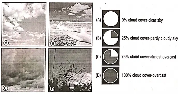
Cloud cover or cloudiness
The measurable proportion of cloud in the sky is called ‘cloud cover’ or ‘cloudiness’. When the cloud cover is 0% it is a clear sky, when it is 25%, it is partly cloudy sky, when it is 75%, it is an almost cloudy sky and when it is 100%, it is the completely cloudy sky.
6. Precipitation
The particles of water or ice form within clouds and fall towards the Earth surface is precipitation. According to famous climatologist H.J. Critchfield, “‘ Precipitation is defined as water in liquid or solid forms falling to the Earth/’ Precipitation includes all forms in which the moisture falls on the Earth’s surface.
It is the process by which condensed water from the clouds falls on the Earth’s surface. It can be solid or liquid. Precipitation is a complex process when millions of drops of water combine together and fall on the Earth.
Different forms of precipitation are
- Rainfall
- Snow-fall
- Hail
- Sleet
- Mist
- Drizzle.
1. Rainfall
The release of moisture in the form of drops of water is called rainfall. After condensation of moist laden air, clouds are formed. The drops of water become so heavy that air cannot hold these. The falling of these drops of water from the clouds is called ‘rainfall’.
Mechanism of Rainfall
If the dewpoint temperature is below freezing, condensation produces minute water droplets and clouds for rainfall, millions of cloud droplets must somehow join together into drops large enough to sustain themselves during their descent.

Types Of Rainfall :
Ordinary rainfall is considered to be of three types :
- Connectional rainfall.
- Orographic or Relief rainfall.
- Cyclonic or Frontal rainfall.
Isohyet
An imaginary line shown on the map joining the places of an equal amount of rainfall of a certain period (such as a month, a season or a year) is called as isohyet.
The instrument used to Measure Rainfall :
The amount of rainfall is measured by an instrument called ‘Rain Gauge’.

2. Snowfall
A form of precipitation consisting of crystals of ice is called ‘snow’. It is produced when condensation takes place at a temperature below freezing point (0°C).
So that the minute crystals of ice form directly from the water vapour. These small crystals then unite of form flakes of ice is called snow.
“factors affecting climate WBBSE class 6 notes”
The coming down of snowflakes towards the Earth’s surface Is known as ‘snowfall’. It is common in higher latitudes and high mountain regions.
3. Hail
Precipitation in the form of pellets of ice (hailstone) that develop in and fall from a cumulonimbus cloud, either at a cold front or where intense heating of the surface causes rapidly ascending convection currents is called ‘hail’. It causes damage to crops and buildings.
“role of the sun in weather and climate class 6”
4. Sleet
In the United Kingdom (U.K.), sleet is described as a form of precipitation consisting of either partly melted snow-flakes or rain and snow falling together.
In the U.S.A., sleet is described as a form of precipitation consisting of frozen raindrops that have subsequently by partially remelted. So, sleet is considered as a mixture of rain and snow.
5. Mist
A reduction of visibility within the lower atmosphere to 1-2 km. caused by condensation producing water droplets within the lower layers of the atmosphere is called ‘mist’. It is intermediate between fog and haze.
6. Drizzle
Light rainfall, consisting of particles in size less than 0-5 mm in diameter that are close together is called drizzle. Normally drizzle is produced by ‘stratus’ and ‘strato-cumulus’ clouds.
Forecasting Of Weather
Weather influences our life and activities to a great extent. As the weather is the day-to-day condition of the atmosphere, it changes regularly. Weather forecasting is the prediction of weather for the next hour, next day, next few days or next week.
These are made by collecting as’ much data as possible particularly temperature, humidity,.rainfall and wind. Predictions are thus made by depending on these data.
“major climatic zones of the world WBBSE”
Weather forecasting is done by weather offices with the help of different instruments as well as satellite pictures and the collected data. Weather forecasting has immense importance for aviation, navigation, fishing activities in the deep sea, agricultural fields and for other human activities.
We come to know about the weather reports and the forecast through radio, television and daily newspapers. Military operations, parliamentary sessions, geographical expeditions, important events of sports etc. take into consideration of weather recordings. We plan our daily activities also based on the weather forecast.
WBBSE Notes for Class 6 Junior School Geography
- Chapter 1 The Universe and Solar System
- Chapter 2 Shape of The Earth: Is The Earth Around?
- Chapter 3 Location of a Place on The Earth’ Surface: Where You Are
- Chapter 4 The Earth’s Motion: The Earth Rotation
- Chapter 5 Water – Land – Air
- Chapter 6 The Ice Capped Continent: Antartica
- Chapter 7 Weather And Climate
- Chapter 8 Air Pollution
- Chapter 9 Noise Pollution
- Chapter 10 India
- Chapter 11 – Maps