WBBSE Madhyamik Model Question Paper 2023 Geography And Environment Set 2

Group A Write The Correct Answer From The Given Alternatives:

Question 1. The gorge formed in the arid regions is called as

  1. Canyon
  2. V-Shaped valley
  3. Potholes
  4. Dhand

Answer: 1. Canyon

Question 2. Bird-foot delta is formed at the mouth of

  1. River Nile
  2. Hwang Ho
  3. Indus river
  4. Mississippi-Missouri river

Answer: 4. Mississippi-Missouri River

Question 3. The Meteors that come towards the earth get burnt in the layer of

  1. Ionosphere
  2. Stratosphere
  3. Mesosphere
  4. Exosphere

Answer: 3. Mesosphere

Read and Learn also WBBSE Madhyamik Model Question Paper 2023 Geography And Environment

Question 4. A Tornado, the most destructive cyclone of the world is also called in the USA as

  1. Cyclone
  2. Twister
  3. Typhoon
  4. Hurricane

Answer: 2. Twister

WBBSE Madhyamik Model Question Paper 2023 Geography And Environment Set 2

Question 5. The merging of the cold Labrador current and warm Gulf Stream current creates dense fogs and stormy weather conditions along

  1. New found land Coast
  2. Guinea Coast
  3. Florida Cost
  4. Peru Coast

Answer: 1. Newfoundland coast

Question 6. On the days of Neap Tides, the sun and the moon are at the following angles to each other in respect of the earth

  1. 180°
  2. 360°
  3. 90°
  4. 120°

Answer: 3. 90°

Question 7. The following waste material is non-biodegradable by its nature

  1. Plastic wastes
  2. Synthetic rubber wastes
  3. Aluminium sheet
  4. All are applicable

Answer: 4. All are applicable

WBBSE Madhyamik Geography Model Question Paper 2023 Set 2 PDF Download

Question 8. The Telangana State was formed by separation from

  1. Madhya Pradesh
  2. Andhra Pradesh
  3. Bihar
  4. Uttar Pradesh

Answer: 2. Andhra Pradesh

Question 9. The plain, which is formed along the foothills of Siwalik Himalaya by the deposition of small rock fragments is called as

  1. Khadar
  2. Bhangar
  3. Bhavan
  4. Bet

Answer: 3. Bhavan

Question 10. An example of one salt lake in India is

  1. Pangong lake
  2. Bhimtal
  3. Dal lake
  4. Loktak lake

Answer: 1. Pangong lake

Class 10 Maths Class 10 Social Science
Class 10 English Class 10 Maths
Class 10 Geography Class 10 Geography MCQs
Class 10 History Class 10 History MCQs
Class 10 Life Science Class 10 Science VSAQS
Class 10 Physical Science Class 10 Science SAQs

Question 11. The Laterite soil is found in the region of

  1. Ganga plain
  2. The western slope of western Ghat
  3. Sundarban
  4. Desert region

Answer: 2. Western slope of western ghat

Question 12. Wheat is a

  1. Rabi crop
  2. Kharif crop
  3. Zaidcrop
  4. Beverage crop

Answer: 1. Rabi crop

Question 13. The proposed fastest National Highway, which will connect Srinagar in the North with Kanyakumari in the South is called as

  1. The East-West Corridor
  2. The Golden Quadrilateral
  3. The North-South Corridor
  4. The North Central Corridor

Answer: 3. The North-South Corridor

Question 14. The Satellite sent by India is

  1. IRS
  2. LANDSAT
  3. SPOT
  4. Station

Answer: 1. IRS

Group B If The Statement Is True, Write ‘True’ And If False, Write ‘False’ Against The Following (Answer Any Six Statements):

Question 1. Potholes are formed at the base of the waterfall.
Answer: False

Question 2. The air pressure is measured by the help of Fortin’s Barometer.
Answer: True

Question 3. Changes of seasons is observed in the Equatorial region.
Answer: False

Question 4. The drought conditions develop in the western coast of South America due to the influence of El Nino of the Pacific Ocean.
Answer: False

Question 5. Tropical Evergreen forests are found in the states of Bihar and Chhattisgarh.
Answer: False

Question 6. Petrochemical Industry is called as “Modern Industrial Giant”.
Answer: True

Question 7. ‘Platform’ is the place in space where the Satellites are installed.
Answer: True

West Bengal Madhyamik 2023 Geography and Environment Set 2 Question Paper with Solutions

Fill In The Blanks With Suitable Words (Answer Any Six):

Question 1. According to the name of ______ river, the zigzag course of a river is known as a meander.
Answer: Meanders

Question 2. Horizontal and Parallel cracks or fractures found on the surface of a glacier are called ______.
Answer: Crevasse

Question 3. Temperature increases with the increase of altitude in the atmosphere is called ______.
Answer: Inversion of temperature

Question 4. During high tide, huge tidal waves entering through the mouth of a river from the sea are called as _____.
Answer: Tidal bore

Question 5. The wastes which after decomposition mix with air, water and soil are called as ______.
Answer: Biodegradable wastes

Question 6. ______ is the highest part of the Meghalaya Plateau.
Answer: Shillong

Question 7. According to the 2011 census, the percentage of literacy rate in India is ______.
Answer: 74.04

Madhyamik Geography and Environment Model Paper 2023 Set 2 Free Download

Answer In One Or Two Words (Any Six):

Question 1. What is the name of the Sandy desert in the Sahara?
Answer: Erg

Question 2. In which layer of the atmosphere jet plane flies?
Answer: Stratosphere

Question 3. What is the main food of marine fish?
Answer: Plankton

Question 4. Name one radioactive waste.
Answer: Uranium, Plutonium, Thorium.

Question 5. Which one is the longest river of South India?
Answer: Godavari

Question 6. In which forest of India lion is found?
Answer: Gir Forest in Gujarat

Question 7. Name the common multipurpose river valley project of the states of Jharkhand and West Bengal.
Answer: Damodar Valley Project

Question 8.In which type of map, relief is shown by contour lines?
Answer: Topographical maps

madhyamik physical science question paper 2024

Match The Left Column With The Right Column:

Left column                                                             Right column
Tal                                                                         1. Coffee Research Centre
Jhum Cultivation                                                   2. Diesel Rail Engine
Chikmagalur                                                          3. Lakes in Western Himalayas
Benaras                                                                  4. Soil erosion

Answer:
Tal: 3. Lakes in Western Himalayas
Jhum Cultivation:  4. Soil erosion
Chikmagalur:  1. Coffee Research Centre
Benaras: 2. Diesel Rail Engine

Group C Answer The Following Questions In Brief (Alternatives Should Be Noted):

Question 1. How are the “deflation hollows” formed?
Answer: ‘Deflation hollows’ or deflation basins are formed by sweeping away of loose, light and dry sand particles by wind. They are also known as ‘desert hollows’ or ‘blow-outs’.

Or, What is Iceberg?
Answer:

Iceberg: Huge blocks of ice that break off from glaciers and fall into the sea are called icebergs.

Question 2. What is ‘Chinook’?
Answer:

Chinook: Chinook is a warm, dry, gusty wind blowing down the Rocky mountains by the eastern slopes into the western prairies.

Or, What is the apogean tide?
Answer:

Apogean tide: When the moon is farthest from the earth (4,03,320 km), this position is known as Apogee. Due to the reduced attraction of the moon, the tide is also 20% less high. This is known as Apogean tide.

Question 3. How is the segregation of waste materials done?
Answer:

The separation of wastes at the source of the collection is known as the segregation of wastes. This reduces the cost of transportation, and energy and helps in acquiring organic stock for energy generation. Wastes may be categorised as:
1. Bio-degradable: Kitchen wastes, garden trimmings, paper, etc.
2. Non-biodegradable: Plastics, glass, old medicines, containers, etc.

Or, What do you mean by ‘Recycling the waste’?
Answer:

Waste Recycling: The method by which old items are used once again to produce the same item is called recycling. Ex-paper, glass, plastic, metals, etc. But the materials produced after recycling are lesser in amount than the initial waste material used.

Question 4. Mention two purposes of rainwater harvesting.
Answer:

Two purposes of rainwater harvesting are:

1. It provides an independent water supply during regional water restrictions or droughts.
2. It can mitigate flooding of lowlands.

Question 5. State the importance of terrace cultivation.
Answer:

Importance of terrace cultivation

Terrace cultivation, is a method of growing crops on the sides of hills or mountains by planting on graduated terraces built into the slope.

Or, What is Sustainable development?
Answer:

Sustainable development: Sustainable development refers to the process of meeting human development goals while sustaining the ability of natural systems to provide resources and services upon which the economy and society depend. It is the organising principle for sustaining finite resources necessary to provide for the needs of future generations.

Question 6. What is meant by satellite Imagery?
Answer:

Satellite imagery: The images prepared by information sent by the satellites are called satellite imagery. These are prepared by reading and representing the signals sent by the satellites with the help of high technological know-how.

Or, Define a topographical Map.
Answer:

Topographical map: The map that represents the physical as well as cultural features of a place at a time with the help of certain colours and conventional symbols, is called a topographical map.

WBBSE Class 10 Geography Sample Paper 2023 Set 2 with Answers

Group D Give a brief explanatory answer to the following (Alternatives should be noted):

Question 1. Explain why a delta is formed at the mouth of a river. 
Answer:

Formation of Delta: The velocity of the river is almost nil where it meets with the sea. Thus, the heaviest amount of depositions occurs here. The main channel is broken into numerous distributaries as more and more depositions take place. The region acquires a triangular shape and looks like the Greek letter Delta, hence the name.

Or, Why does temperature decrease with the increase of altitude in the Troposphere?
Answer:

Atmospheric temperature decreases with an increase in altitude for the following reasons:

1. Insolation first heats up the earth’s surface. This heat is radiated into the atmosphere, gradually heating the layers from bottom to top.
2. The upper layers of the atmosphere are less dense and can rapidly radiate out heat and get cooled.
3. Pressure is less in the upper levels of the air, hence their heat absorbing capacity is also less.

Question 2. What are the methods of controlling gaseous waste material?
Answer:

Method to control gaseous waste: Wet scrubbing is a method of using a liquid to remove solid, liquid or gaseous wastes and pollutants. The scrubbing liquid is sprayed into the disposed of gas in a spray chamber. Contact with the spray liquid removes the particulate pollutants of the gas. Dry scrubbing is also a popular method.

Or, How are the reduction of waste made?
Answer:

Methods of waste management:

1. Reduction: This is a process of waste minimisation at the source itself, and elimination of harmful and persistent wastes. This involves re-designing of products in order to reduce the production of waste at home, work or other places.
2. Reuse: To reuse is to use an item again after it has been used before. Reuse helps to save time, money, energy and resources. E.g. Packing boxes, gift wrappers, toys, etc.
3. Recycling: Recycling is processing used materials into new, useful products. It helps to save raw materials, energy and money and controls pollution and environmental degradation. E.g. Newspapers, iron items, etc.

Question 3. What do you mean by the ‘Modern Communication System’?
Answer:

Modern Communication System

Communication is the exchange of ideas, information, messages and feelings between people, without any physical movement of people concerned and the system that enables this is called the modern communication system. It can be divided into three parts.

1. Collection of information and messages to be communicated (input).
2. Medium through which the messages will be communicated (through-put).
3. Communicating or enabling the messages to reach successfully (output).

Question 4. What are the differences between Topographical Map and Satellite Imagery?
Answer:

The differences between Topographical Map and Satellite Imagery

WBBSE Solutions For Class 10 Geography And Environment Chapter 6 Satellite Imaginary And Topographical Map satellite-imageries-and-topographical-maps

Or, State three uses of Topographical Map.
Answer:

Characteristics of Topographical Map:

1. The topo sheets are prepared to precise scales. Hence location or size of objects can be represented accurately.
2. Relief and landforms can be represented by spot heights accurately.
3. The accurate representation of drainage lines helps to understand the drainage pattern and nature of drainage.
4. Representation of settlements, transport system, etc. helps to understand the economic condition of the region.

Group E Answer Any Two Questions From The Following:

Question 1. Describe with sketches the major landforms produced by fluvioglacial deposition.
Answer:

The landforms formed by glacial deposition are:

WBBSE-Solutions-For-Class-10-Geography-And-Environment-Chapter-1-Exogenic-Processes-And-Resultant-Landforms-Fluvio-Glacial-Deposition

1. Moraines: Any landform formed by depositions of the valley and continental glaciers is called a moraine. The moraines can be mainly of three types:
(1)Moraines deposited alongside of glacial valley floor are called lateral moraines,
(2)Where two lateral moraines of adjacent glaciers combine, the deposition lying in the middle of the main glacier is called medial moraine,
(3)Moraines deposited at the end of a glacier are called terminal or end moraines.

2. Eskers: Long ridges of material deposited parallel to the direction of the flow of glacial melt water are called eskers. glacial meltwater is called eskers.
3. Erratics: These are depositions of boulders and rock fragments in an area where they are a total mismatch with the surroundings.

4. Drumlins: These are low elongated hills formed by glacial deposits. They are called ‘basket of eggs’ topography.

WBBSE-Solutions-For-Class-10-Geography-And-Environment-Chapter-1-Exogenic-Processes-Drumlin

Question 2. Explain with sketches the origin and direction of planetary winds of the world.
Answer:
Orographic or Relief rain: When clouds on their way dash against hills, plateaus, etc., they rise up. Higher up the clouds condense and then rain falls on the slopes of the mountain and the plateaus. When it goes to the other (opposite) side of the hills, plateaus, etc., it is left with little water vapour.

WBBSE-Solutions-For-Class-10-Geography-And-Environment-Chapter-2-Atmosphere-Orographic-Rainfall
Therefore, the rainfall is much less on the opposite side. This type of rain is called relief rain as it is caused mainly due to the relief of the land. The opposite side of the hill where the rainfall is much less is called the rain shadow area. The Deccan plateau is an example of a rain-shadow region in India. Orographic or Relief rain.

Question 3. Discuss the major characteristic features of Tropical Monsoon climatic regions.
Answer:

The word monsoon is derived from the Arabic word Muslim meaning season. The monsoon wind is a seasonal wing as it is very much associated with rain, it invariably means the rainy season.

Characteristics of this climatic region are stated below:

1. The monsoon winds change their direction according to seasons (in summer and in winter).
2. The summer monsoons bring rains as they come from the seas winter, monsoons remain rainless as they generally blow from the land.
3. Summers are hot and wet, and winters are pleasantly warm and almost rainless.
4. The summer temperature ranges between 27°C and 32°C.
5. The winter temperature varies between 13°C and 22°C.
6. The range of temperature between day and night, and between summer and winter is considerably wide; it is about 10°C to 15°C.
7. The rains come in the latter half of summer.
8. The amount of rainfall varies from place to place according to landform features. Generally, this region has an average rainfall between 100 cm and 200 cm.

Question 4. Explain the factors responsible for the origin of ocean currents.
Answer:

Causes of Origin of Ocean Currents: The main causes of the origin of ocean currents are:

1. Prevailing winds: The planetary winds or prevailing winds push the surface layers of the ocean water in front of them in a constant flow. If due to seasonal changes, the direction of the wind is changed, the currents also have a similar change in their direction. In Tropical areas, the equatorial currents moving along with trade winds move from east to west. In Temperate regions, westerlies drive the seawater from west to east.

2. Difference in temperature: Temperature is low at the poles and high at the equator. The polar water is cool and becomes heavy and sinks. The equatorial water is warm, light and floats. This creates a convectional current and the polar water moves towards the equator and vice versa.

3. Difference in salinity: The salinity of ocean water varies from place to place. Water of high salinity is denser than water of low salinity. Hence, water of high salinity flows on the surface while the water of high salinity flows at the bottom of the oceans.
4. Rotation of the earth: The rotation of the earth generates a centrifugal force, which causes the generation of currents in the ocean water.

5. Shape of coasts: The shape and direction of the coasts of the landmasses also change the direction of the currents.
6. Centrifugal force: The centrifugal force of the earth is greater at the equator than at the poles. Hence, water currents move from the equatorial region to the poles.

7. Evaporation and rainfall: Evaporation decreases the water level and increases salinity while rainfall increases the water level and decreases salinity. This influences the flow of ocean currents.
8. Melting of ice: The melting of ice raises the sea level and reduces salinity, influencing ocean currents.

West Bengal Board Madhyamik Geography 2023 Set 2 Previous Year Paper

Question 5. Give a brief account of the physiography of Western Himalayas of India.
Answer:

Physiography of Western Himalaya: According to SirS. Burrard, the Himalayas are generally regarded as consisting of the following four main sections which are separated from one another by the gorges of rivers which pass through them:

(1)The Punjab HimalayasThis section between the Indus and the Sutlej is known as the Punjab Himalayas. It is also called Jammu-Kashmir and Himachal Pradesh Himalaya because most of this section is located in these two states. This section is 560 kilometres long. The important ranges of this section are the Ladakh, the Pir Panjal, the Dhaoladhar and the Zanskar. The Zoji La pass is at an altitude of 3,444 metres above the sea-level.

(2)The Kumaon Himalayas This section runs for a distance of 320 kilometres between the Satluj and the Kali rivers. This is higher than the Punjab Himalayas. Great rivers like Ganga and Yamuna have their sources in the Kumaon Himalayas.

(3)The Upper HimalayasThis is situated between the Kali and the Tista rivers and is 800 kilometres long. This is the highest part of the Himalayas where lofty peaks like the Mt. Everest, the Kanchenjungha, the Dhaulagiri, the Annapurna, the Makalu, etc. are located. The flat Kathmandu valley is also situated in the Nepal Himalayas.
(4)The Assam HimalayasIt extends for a distance of 720 kilometres between the Tista and the Dihang (Tsangpo-Brahmaputra).

Question 6. Describe the favourable physical conditions required for cultivation of cotton in India.
Answer:

The favourable conditions for growing cotton are:

Geographical:

1. Temperature: 23° – 32°C with an average around 27°C.
2. Sunshine: Plenty of sunshine during the growing period and cooler conditions during harvest.
3. Rainfall: 50-80 cm of rainfall well-distributed during the growing period. But rainfall is injurious after the budding period.
4. Frost: At least 200 frost-free days are required.
5. Soil: Black cotton soil or regular soil is the best for cotton.
6. Land: Flat or undulating land with good drainage and no water logging is good for cotton.

Economic:
1. Labour: Much labour is required for planting, thinning of seedlings, hoeing, an inspection of pests, picking of balls, etc.
2. Transport: Good transport system helps in carrying raw cotton to factories and finished products to markets.
3. Fertilisers and pesticides: Cotton is highly soil-exhaustive. Hence fertilisers are necessary to maintain soil fertility. Pesticides are used to control pest attacks.
4. HYV: High yielding variety of seeds like MCU-4, MCU-5, Hybrid-4, Sujata, Varalaxmi, etc. help to raise the yield of cotton per hectare.

Madhyamik Geography and Environment Question Paper 2023 Set 2 in Bengali

Question 7. Explain the major factors responsible for the development of Iron and Steel industry in Eastern and Central India.
Answer:
Factors responsible for the development of the Iron and Steel Industry: Most of the iron and steel plants of India, such as Jamshedpur, Burnpur, Durgapur, Rourkela, Bhilai and Bokaro are located in Jharkhand, West Bengal, Odisha and Chattisgarh. The causes for the concentration of iron and steel plants in eastern India are:

1. Iron ore: About 80% of India’s iron ore is available in this region. The major mines are
(1) Noamundi, Guwa, Budaburu, Pansiraburu of Singhbhum district, Jharkhand,
(2) Gurumahishani, Badampahar, Sulaipat and Bonai of Mayurbhanj district and Bagiyaburu of Keonijhar district, Odisha.

2. Coal: About 97% of India’s coal is mined in this region. The steel plants of Kulti, Burnpur, and Durgapur get their coal from the mines in Raniganj and Asansol. The steel plants of Jamshedpur, Bokaro and Rourkela get their coal from Jharia, Bokaro, Ramgarh and Giridih in Jharkhand.
3. Other raw materials: Limestone, dolomite, manganese, etc. are collected from Kalahandi, Gangapur and Kara put of Odisha. Other raw materials like chromium, tungsten, nickel, etc. are easily collected from the Chotanagpur plateau.

Question 8. Discuss the causes of Urbanisation in India.
Answer:

Causes of Urbanisation in India: The different causes of urbanization in India are

1. Limited size of agricultural land: The limited size of agricultural land in India cannot provide employment to the whole rural population. Hence, unemployment, poverty and other problems push the rural population to the urban centres.
2. Change in thought: The mentality of rural people is also changing. They wish to settle in urban areas for educational facilities, trade, commerce, industrial jobs, etc.

3. Free lifestyle: Urban life is much more liberal and free from superstitions. Rural people thus tend to settle in urban areas.
4. Employment: The scope of employment is much higher and varied in urban areas. Hence, the rural population is attracted towards urban areas.
5. Entertainment: Urban areas have much more scope for entertainment and relaxation. This attracts much rural population.


WBBSE Madhyamik Model Question Paper 2023 Geography And Environment Set 1

Group A Write The Correct Answer From The Given Alternatives:

Question 1. The process by which natural agents reshape the existing landscape over the earth’s surface is known as

  1. Exogenetic process
  2. Endogenetic process
  3. Orogenetic process
  4. Epeirogenetic process

Answer: 1. Exogenetic process

Class 10 Maths Class 10 Social Science
Class 10 English Class 10 Maths
Class 10 Geography Class 10 Geography MCQs
Class 10 History Class 10 History MCQs
Class 10 Life Science Class 10 Science VSAQS
Class 10 Physical Science Class 10 Science SAQs

Question 2. The main erosional process of rivers over salt-dominated rock is

  1. Abrasion
  2. Attrition
  3. Hydraulic action
  4. Solution

Answer: 4. Solution

Read and Learn also WBBSE Madhyamik Model Question Paper 2023 Geography And Environment

Question 3. The uppermost layer of the heterosphere is

  1. Hydrogen layer
  2. Helium layer
  3. Atomic oxygen layer
  4. Molecular nitrogen layer

Answer: 1. Hydrogen layer

West Bengal Madhyamik 2023 Geography and Environment Question Paper with Answers”

Question 4. The instrument by which humidity of air mass is measured

  1. Thermometer
  2. Barometer
  3. Hygrometer
  4. Anemometer

Answer: 3. Hygrometer

Question 5. The influence of EL-Nino is observed in

  1. Atlantic Ocean
  2. Pacific Ocean
  3. Indian Ocean
  4. Arctic Ocean

Answer: 2. Pacific Ocean

WBBSE Madhyamik Model Question Paper 2023 Geography And Environment Set 1

Question 6. When the distance between the earth and the moon becomes least, the generating tide is called

  1. Spring tide
  2. Neap tide
  3. Perigean tide
  4. Apogean tide

Answer: 1. Spring tide

Question 7. The processes of waste management involve

  1. Reuse of waste
  2. Recycling of waste
  3. Reduction of waste
  4. All of them

Answer: 4. All of them

Question 8. The youngest state of India is

  1. Uttarakhand
  2. Telangana
  3. Chhattisgarh
  4. Goa

Answer: 2. Telangana

Question 9. Dust storms in North-West India in summer are called

  1. Kalbaishakhi
  2. Andhi
  3. Western Disturbance
  4. Loo
  5. Answer: 2. Andhi

Question 10. A method followed in India to conserve soil is

  1. Irrigation
  2. Jhum cultivation
  3. Strip cropping
  4. Animal rearing

Answer: 3. Strip cropping

Question 11. The state which ranks first in jowar production in India is

  1. Maharashtra
  2. Uttar Pradesh
  3. Bihar
  4. West Bengal

Answer: 1. Maharashtra

Question 12. The “Silicon Valley of India” refers to

  1. Chennai
  2. Bengaluru
  3. Kolkata
  4. Delhi

Answer: 2. Bengaluru

Question 13. The longest National Highway in India is

  1. National Highway 1
  2. National Highway 2
  3. National Highway 6
  4. National Highway 7

Answer: 4. National Highway 7

Question 14. The R.F. of a topographical map with 15’xl5′ latitudinal and longitudinal extension is

  1. 1: 2,50,000
  2. 1: 1,00,000
  3. 1: 50,000
  4. 1: 25,000

Answer: 3. 1: 50,000

WBBSE Class 10 Geography Sample Paper 2023 with Solutions

Group B If The Statement Is True, Write ‘True’ And If False, Write ‘False’ Against The Following:

Question 1. Seif dunes are transformed from Barkhan dunes.
Answer: True

Question 2. The ozone layer is known as “Natural sun-screen”.
Answer: True

Question 3. In Mediterranean regions, rainfall generally occurs in summer.
Answer: False

Question 4. The Strait line alignment of the Sun, the Moon, and the Earth is called Syzygy.
Answer: True

Question 5. Most of the rice in India is cultivated in winter as a Rabi crop.
Answer: False

Question 6. The most densely populated state of India is West Bengal.
Answer: False

Question 7. Different symbols are used to show geographical features in satellite images.
Answer: False

Fill In The Blanks With Suitable Words:

Question 1. The plantation of landmass caused by different exogenic forces is called ______.
Answer: Graduation.

Question 2. Long, narrow, winding, steep-sided, ridges formed by the fluvioglacial deposits of sands and gravels is called __________.
Answer: Esker.

Question 3. In the Rainfall-Temperature graph of any place, if the temperature curve becomes downward during mid of the year then the station lies in _____ hemisphere.
Answer: Southern.

Question 4. ______ force of the earth causes secondary high tide.
Answer: Centrifugal.

Question 5. Air conditioners emit ______ gas into the atmosphere.
Answer: CFC.

Question 6. Bhagirathi and _______ river meet at Devprayag to form the river, Ganga.
Answer: Alakananda.

Question 7. ______ city is called the “Manchester of South India”.
Answer: Coimbatore.

WBBSE 10th Geography Model Paper 2023 Set 1 Solved

Answer In One Or Two Words (Any Six):

Question 1. Name the high land that separates two river systems.
Answer: Watershed

Question 2. What is the relative humidity of saturated air?
Answer: 100%.

Question 3. What type of current originates in tropical oceans?
Answer: Warm current.

Question 4. What type of waste material is plastic?
Answer: Solid waste.

Question 5. Name the highest mountain pass in India.
Answer: Dungri La or Mana pass.

Question 6. Where is the largest mangrove forest in the world located?
Answer: Sundarban.

Question 7. Which soil of India is ideal for cotton cultivation?
Answer: Black soil.

Question 8. Which roadway has connected Delhi, Mumbai, Chennai, and Kolkata?
Answer: Golden Quadrilateral.

Match The Left Column With The Right Column:

Left Column                                                      Right Column
ISRO                                                                   1. Kerala
Vembanad                                                          2. Tax-free port of India
Andhi                                                                  3. Indian Space Research Organisation
Kandla                                                                 4. Rajasthan

Answer:

ISRO: 3. Indian Space Research Organisation
Vembanad:  1. Kerala
Andhi: 4. Rajasthan
Kandla: 2. Tax-free port of India

Group C Answer The Following Questions In Brief:

Question 1. How are the bird’s foot deltas formed?
Answer: The deltas that look like a bird’s claw or fingers spreading one beside the other, are called bird’s foot deltas. Eg. the Delta of the river Mississippi in North America.

Or, What is Bergschrund?
Answer:

Bergschrund: A bergschrund is a long narrow crack developed at the source of the glacier. This is created when the mass of ice tends to flow down due to gravity and the mountain’s walls tend to hold back the ice due to friction.

Question 2. Mention two characteristic features of jet streams.
Answer:

Characteristic features of Jet Streams:

1. It blows from west to east.
2. The length of the jet stream can be a few thousand kilometers.

Or, What is a tidal bore?
Answer:

Tidal Bore: When a tide enters the narrow and shallow estuary of a river, the front of the tidal wave appears to be vertical, owing to the piling of water of the river against the tidal wave and friction against the river bed. The steep-nosed tide crest looks like a vertical water of water rushing upstream. This is called a Tidal Bore.

Question 3. What do you mean by landfills in waste management?
Answer:

Landfill: Landfilling is the most common method of waste disposal, where the wastes are buried underground. But this method is not of much use in modern days, as this requires a huge vacant land for this purpose.

Or, What is meant by recycling waste?
Answer:

Waste Recycling: The method by which old items are used once again to produce the same item is called recycling—ex-paper, glass, plastic, metals, etc. However the materials produced after recycling are lesser in amount than the initial waste material used.

Question 4. Define “Burst of Monsoon”.
Answer:

Burst of Monsoon

The southwest monsoon in India is noted for its dramatic arrival with a rainy spell of weather continuing for some days. It is called the ‘burst’ which takes place by the end of May in Kerala and by the 7th of June in West Bengal. By July the whole of India is brought under the influence of monsoon.

Or, Mention two purposes of “Social Forestry”.

Answer:

Purposes of “Social Forestry”

Social forestry is a philosophy of growing trees/forests outside the periphery of well-known forested areas with different governmental statuses. It includes farm forestry, rural extension forestry, roadside plantation or agriculture and urban or recreational forestry, etc.

Question 5. What do you mean by subsistence agriculture?
Answer:

Subsistence Agriculture: The practice of agriculture in which small landholdings are cultivated with primitive methods and tools, and the product is almost entirely consumed by the family members of the farmers, with a little surplus for sale, is called subsistence farming. This type of agriculture is mainly practiced for survival.

Or, Define the Information Technology industry.
Answer:

Information Technology industry

Information Technology is the application of computers and telecommunication equipment to store, retrieve, transmit, and manipulate data in the context of a business or other enterprise. The term is now used as a synonym for computers and computer networks. Several other industries associated with Information Technology are —computer hardware, software, electronics, semiconductors, internet; telecom equipment, e-commerce, and computer services.

Question 6. What are the Geostationary satellites?
Answer:

Geo-stationary Satellite: Geostationary Operational Environmental Satellites (GOES) remain above a fixed location on the earth’s surface, approximately 22,500 km above the equator. They rotate at the same speed as the earth and so they always view the same portion of the globe.

Or, What is “Remote sensing”?
Answer:

“Remote sensing”

Remote sensing is the method of gathering information about any region or object on the earth’s surface or the surface of other planets from a considerable distance, without coming in physical contact. This information helps in analyzing the region or the object.

Group D Give Brief Explanatory Answers To The Following:

Question 1. Why wind action is dominant in desert regions?
Answer: Although the wind blows over the whole of the earth, its action is predominant in arid regions.

This is because:
1. No obstacle in wind direction: In desert regions, due to lack of rainfall, there is no or very less vegetation cover. Thus wind blows unhindered at high speed.

2. Loose and exposed soil: Lack of vegetation makes the soil loose and exposed to wind action.
3. High diurnal range of temperature: A great difference between day and night temperature causes rocks to crack and break due to contraction and expansion. This makes the work of the wind easier.

Or, Discuss the differences between sea breeze and land breeze,
Answer:

Differences between sea breeze and land breeze:

Sea Breeze Land Breeze
1. It blows during the daytime. 1. It blows during the nighttime.
2. It blows from the sea towards the land. 2. It blows from the land towards the sea.
3. It happens due to unequal heating of land and sea. 3. It happens due to unequal rates of radiating heat by land and sea.


Question 2. State the differences between bio-degradable and non-biodegradable wastes.

Answer:

Bio-degradable wastes:

1. Complex biotic materials are converted to simple biotic materials.
2. Generated from plant and animal wastes.
3. Eg: wood, paper, kitchen wastes, food remains, etc.

Non-biodegradable wastes:
1. Wastes cannot be converted to simple substances.
2. Generated from sources other than plants and animals.
3. Eg: polythene, PVC, plastic, DDT, etc.

Or, What are the advantages of the waste composting process?
Answer:

Advantages of the waste composting process:
1. It helps to increase the biotic or organic components of the soil.
2. The compost formed is highly useful in agriculture.
3. Composting helps to largely reduce the number of solid biodegradables.

Question 3. Discuss about three major uses of satellite imageries.
Answer:

Uses of satellite imageries:

1. The satellite imageries may be of the total hemisphere or a segment of the earth’s surface.
2. Information on relief, and physical processes, such as works of rivers, wind, glaciers, etc., distribution or resources, groundwater resources, etc. can be gathered easily by studying satellite imageries.
3. Imageries of rugged terrains, such as mountainous regions can be captured easily.

Or, Give an account of different types of scales used in “topographical maps”.
Answer:

Different types of scales used in “topographical maps” are

Map scale represents the relationship between the distance of any two points on the map and the actual distance between the same two points on the ground. It can be expressed as a map distance between two points Scale – the ground distance between the same two points
The scale of the topographical map is found at the bottom centre of the map. There are three ways in which the scale of a map is expressed :
1. Statement scale.
2. Representative fractions and
3. Linear scale.

1. Statement scale: The statement scale or verbal scale states what distance on the map is equal to what distance on the ground, (for example, 2 cm -1 km). These scales are not usually printed on the topographical map.

2. Representative fraction: Representative fraction (R.F.) or fractional scale (for example 1: 50,000). Fractional scales do not have units. This scale is the ratio of the map distance to the equivalent distance on the ground using the same unit for both. There is flexibility to choose units.

So, we can write, 1 cm on the map = 50,000 cm on the ground or, 1 m on the map = 50,000 m on the ground, and so on.
We can convert the R.F. into a verbal scale.
Example: Convert 1: 50,000 into a statement of scale 1 cm on the map represents 50,000 cm on the ground or, 1cm: 50,000 cm.
or, 1cm: 50,000/100,000 km or, 1 cm : 1/2 km or, 1 cm : 0.5 km.

3. Linear scale: This is just a line drawn on a map of known ground length. It represents the same relationship by means of a straight line which is divided into certain lengths, each of which represents a certain distance on the ground. It has usually a primary division and a second division. This scale allows quick visual estimation of distance. This scale will remain valid if it is enlarged or reduced by the same amount.

Group E Answer Any Two Questions From The Followings:

Question 1. Describe with sketches the landforms developed by the combined action of wind and running water in the arid region.
Answer:

The different landforms formed by the combined action of water and wind in a desert region are:

1. Wadi: In deserts, sudden torrential rains lead to the formation of valleys through which the collected rainwater may flow like a river. In the dry season, these valleys also remain dry.

WBBSE Solutions For Class 10 Geography And Environment Chapter 1 Exogenic Processes Wadi

2. Playa: Playas are small lakes found in deserts. They are highly saline and the water cannot be used for agricultural or household purposes.
3. Pediment: Pediment refers to the eroded and lowered plainlands that lie at the foot of the mountains.
4. Bajada: Bajada refers to the deposition of materials brought down by wind as well as water and deposited beyond the pediment.

Question 2. Explain three major factors responsible for temperature variation in the atmosphere.
Answer:

The word monsoon is derived from the Arabic word Muslim meaning season. The monsoon wind is a seasonal wing as it is very much associated with rain, it invariably means the rainy season.

Characteristics of this climatic region are stated below:

1. The monsoon winds change their direction according to seasons (in summer and in winter).
2. The summer monsoons bring rains as they come from the seas winter, monsoons remain rainless as they generally blow from the land.
3. Summers are hot and wet, and winters are pleasantly warm and almost rainless.
4. The summer temperature ranges between 27°C and 32°C.
5. The winter temperature varies between 13°C and 22°C.
6. The range of temperature between day and night, and between summer and winter is considerably wide; it is about 10°C to 15°C.
7. The rains come in the latter half of summer.
8. The amount of rainfall varies from place to place according to landform features. Generally, this region has an average rainfall between 100 cm and 200 cm.

Question 3. Give a brief account of the influences of Global Warming.
Answer:

The influences of global warming are discussed below:

1. Melting of glaciers: Global warming increases the average temperature of the earth’s atmosphere, which results in the melting of ice caps and glaciers. This will submerge coastal areas due to an increase in the level of seawater. The fluvial cycles will be disturbed and landforms will change. Many flora and fauna may be destroyed.

2. Climatic change: The northern hemisphere will become hotter than the southern hemisphere due to the presence of more landmasses here. The amount of rainfall in Tropical, regions will increase by 10-15%. The northern countries may experience flood and the southern countries will experience drought in the northern hemisphere. Summers will be longer. The chances of thunderstorms and cyclones will increase.

3. Ecosystem: Change in climate due to global warming may result in the extinction of many species of birds, animals and plants.

4. Spread of diseases: The germs and bacteria will become highly active and spread diseases like Dengue, Malaria, Yellow Fever, Encephalitis, etc. Some tropical diseases may spread to higher latitudes also.

5. Spread of deserts: High temperatures and high rates of evaporation will turn many places arid and hence boost the spread of deserts.

6. Effect on vegetation and agriculture: Excessive heat may hamper the growth of coniferous trees in hilly areas. Mangroves may be drowned due to the rise in sea water level. Some crops like rice, wheat, barley, soybean, tobacco, jute, etc. will reduce their growth.

Question 4. Describe the favorable physical conditions required for the cultivation of sugarcane.
Answer:

Favourable physical conditions required for the cultivation of sugarcane are as follows:

1. Temperature: Average annual temperature of 21°-27°C is favorable for the growth of sugarcane.
2. Rainfall: Average annual rainfall of 75-100 cm is necessary. If rainfall is lesser, irrigation is required.
3. Soil: Sugarcane grows best in loamy soil, black soil, alluvial soil, etc. It does not grow in alkaline salts.
4. Relief: Flat or gently rolling plains are suitable for the cultivation of sugarcane.

Madhyamik Geography and Environment Question Paper 2023 in Bengali

Question 5. Discuss five reasons responsible for the uneven distribution of population in India.
Answer:

Reasons responsible for the uneven distribution of population in India

The regional distribution of the population of India is characterized by its unevenness. There are certain factors that influence the distribution of the population.

They are as follows :

1. Terrain: Plain areas provide a flat, level or gently sloping land for agriculture, development of transport, industries, etc., and attract a large number of people as compared to inaccessible mountains. We, therefore find a higher concentration of population (more than half of India’s population) in the great northern plains of India.

2. Climate: Sparse population is noticed in the cold Himalayan mountains and in the Thar desert having extremes of temperature and dry climate. In India, monsoon rain plays a vital role in determining the concentration of people. The southwest monsoon rains decrease westwards along the Indo-Gangetic plain. The concentration of the population also follows this trend.

3. Soil: Fertile soil supports higher crop production. So, in India areas with fertile soil have a dense population. Therefore, river valleys, coastal plains, black soil regions of the Deccan plateau, etc. have a dense population.

4. Water bodies: A large number of people gather near the sources of water, which is very essential for the sustenance of life. In India, the river valleys, the coastal plains and the areas around lakes are, therefore, thickly populated.

5. Mineral Resources: Mining is an important occupation of people in India next to agriculture. So, a large number of people in India live in the Chotanagpur plateau of Jharkhand, the storehouse of minerals in India.

6. Industries: Industries are called the backbone of a country’s economy. They provide employment to a large number of people, and so, in India industrial areas in the states of Gujarat, Maharashtra, Jharkhand, Orissa, and West Bengal have a high concentration of population.

7. Transport: Population concentration is high in areas with a well-knit network of transport routes. Hence the Great Northern plains of India are thickly populated. Remote mountainous areas with poor transport facilities are sparsely populated.

8. Urbanisation: Urban (city) areas with more civic amenities attract a larger number of people than the villages. So, urbanised areas like Kolkata, Mumbai, Delhi, Chennai, Hyderabad, Chandigarh, etc. have population densities of over 6000 persons sq. km.

9. Historical and Political factors: After the partition of Bengal, the population of West Bengal grew up due to the influx of people from the other side of Bengal.

10. Religious influence: Varanasi, Mathura, Haridwar, Nabadweep, and Puri, the sacred religious centers of the Hindus, Agra of the Muslims, and Amritsar of the Sikhs are densely populated due to religious factors.

WBBSE Madhyamik Model Question Paper 2023 Geography And Environment Set 3

Group A Write The Correct Answer From The Given Alternatives:

Question 1. The process by which, the height of the earth surface increases, is:

  1. Aggradation
  2. Degradation
  3. Weathering
  4. Denudation

Answer: 1. Aggradation

Question 2. Deep cracks on the surface of the mountain glacier are called:

  1. Nunatak
  2. Crevasse
  3. Arete
  4. Cirque

Answer: 2. Crevasse

“WBBSE Madhyamik Model Question Paper 2023 Geography and Environment Set 3”

Question 3. The annual range of temperature remains minimum in the:

  1. Equatorial climatic region
  2. Monsoon climatic region
  3. Mediterranean climatic region
  4. Steppe climatic region

Answer: 1. Equatorial climatic region

Question 4. The cold local wind that blows in the Rhone valley of France is called:

  1. Chinook
  2. Sirocco
  3. Mistral
  4. Bora

Answer: 3. Mistral

Class 10 Maths Class 10 Social Science
Class 10 English Class 10 Maths
Class 10 Geography Class 10 Geography MCQs
Class 10 History Class 10 History MCQs
Class 10 Life Science Class 10 Science VSAQS
Class 10 Physical Science Class 10 Science SAQs

Question 5. The place, where warm and cold ocean currents converge, is called:

  1. Cold wall
  2. Iceberg
  3. Avalanches
  4. Sargassum

Answer: 1. Cold wall

Question 6. When the distance between the earth and the moon is farthest, it is called:

  1. Syzygy
  2. Perigee
  3. Apogee
  4. Aphelion

Answer: 3. Apogee

“WBBSE Class 10 Madhyamik Geography Model Paper 2023 Set 3”

Question 7. In the human body contaminated water may cause:

  1. Diarrhoea
  2. Asthma
  3. Lung cancer
  4. Blindness

Answer: 1. Diarrhoea

Question 8. The main basis of state reorganisation in India is:

  1. Language
  2. Physiographic similarities
  3. Similarities in food habits
  4. Similarities in economic activities

Answer: 1. Language

Question 9. The source of river Ganga is:

  1. Yamunotri Glacier
  2. Zemu Glacier
  3. Siachen Glacier
  4. Gangotri Glacier

Answer: 4. Gangotri Glacier

Question 10. In India the largest multipurpose river valley project is:

  1. Bhakra-Nangal
  2. Damodar
  3. Rihand
  4. Hirakund

Answer: 1. Bhakra-Nangal

Question 11. The state, which ranks first in the production of rice per hectare, is:

  1. West Bengal
  2. Uttar Pradesh
  3. Punjab
  4. Andhra Pradesh

Answer: 3. Punjab

Question 12. The required raw materials of iron and steel industry include:

  1.  Iron ore
  2. Coal
  3. Manganese
  4. All of them

Answer: 4. All of them

“Madhyamik 2023 Geography and Environment Set 3 question paper WBBSE”

Question 13. According to the 2011 census, the number of metropolis in India is:

  1. 55
  2. 53
  3. 51
  4. 49

Answer: 2. 53

Question 14. The latitudinal and longitudinal extension of million sheet topographical map is:

  1. 15°X 15°
  2. 30°X30°
  3. 1°x 1°
  4. 4°x4°

Answer: 4. 4° X 4°

Group B If The Statement Is True, Write ‘True’ And If False, Write ‘False’ Against The Following (Answer Any Six Statements):

Question 1. The altitude of the snowline varies with latitude.
Answer: True

Question 2. Wind velocity is measured with the help of an Anemometer.
Answer: True

Question 3. The salinity of seawater is maximum in the Equatorial region.
Answer: False

Question 4. The highest plateau of India is Deccan Trap.
Answer: False

Question 5. The old alluvial soil of the Ganga plain is called Bhangar.
Answer: True

“WBBSE Madhyamik Geography and Environment Set 3 solved paper 2023”

Question 6. Vishakhapatnam is the only tax-free port of India.
Answer: False

Question 7. Red coloured lines are used to show roads in satellite images.
Answer: False

Fill In The Blanks With Suitable Words (Answer Any Six):

Question 1. Holes formed by abrasion on the river bed are called ______.
Answer: Pothole.

Question 2. ______ is formed by the mixing of dust and fog during winter in industrial regions.
Answer: Fog

Question 3. ______ current causes snowfall in New Foundland.
Answer: Labrador.

Question 4. Waste paper is a ______ type of waste.
Answer: Recyclable

Question 5. Tropical easterly Jet Stream forces ______ wind to blow over India.
Answer: Monsoon

Question 6. The southernmost point of mainland India is ______.
Answer: Kanyakumari

Question 7. _______ is the most populous city of India.
Answer: Mumbai

Answer In One Or Two Words (Any Six):

Question 1. Which type of rainfall is found in the Temperate zone?
Answer: Cyclonic rain

Question 2. Which island of Sundarban was completely submerged due to global warming?
Answer: Lohachara, Needmore.

Question 3. Which type of natural vegetation is found in the desert region of India?
Answer: Xerophytas or Deciduous.

Question 4. On which quarters of the moon, does Neap tide occur?
Answer: Dark and White Half of a lunar month.

Question 5. In which part of the course, is the river Ganga is maximumly polluted?
Answer: Delta or in the old age portion.

“WBBSE Madhyamik Model Paper 2023 Geography Set 3 with answers”

Question 6. Name one Zaid crop of India.
Answer: Watermelon

Question 7. Which state of India leads in “Rain-water Harvesting”?
Answer: Tamilnadu

Question 8. Where is the headquarter of ‘Survey of India’ located?
Answer: Dehradun.

Match The Following Left Column With The Right Column:

Left column                                                                                           Right column
The prominence of Ozone gas                                                             1. Gurgaon
Research Institute of Sugarcane                                                           2. Jammu and Kashmir
Largest automobile manufacturing industrial centre                           3. Stratosphere
Karewa                                                                                                  4. Lucknow

Answer:
The prominence of Ozone gas : 3. Stratosphere
Research Institute of Sugarcane: 4. Lucknow
Largest automobile manufacturing industrial centre  1. Gurgaon
Karewa: 2. Jammu and Kashmir

Group C Answer The Following Questions In Brief (Alternatives Should Be Noted):

Question 1. What is denudation?
Answer:

Denudation

Denudation involves the processes of weathering, erosion and transportation together. It is a term derived from the Latin word ‘denudate’ meaning ‘to strip bare’. It, therefore, causes the removal of rock layers from the earth’s surface resulting in the lowering of the land surface.

Or, What is “inversion of temperature”?
Answer:

Inversion of temperature

Generally there is a decrease in temperature as we ascend upward above sea level, but sometimes temperature increases as we ascend upward. This is known as “Inversion of temperature”.

Question 2. What is an Inter-tropical convergence zone?
Answer:

Inter-Tropical Convergence Zone: In the winter the Indian climate is influenced by the western disturbances originating from the Mediterranean sea and is characterised by snowfall or rainfall (its influence is seen sometimes up to the plains of West Bengal also). Kashmir, Punjab, and Western U.P. receive snowfall or rain during this time.

Or, State the definition of ocean current.
Answer:

Ocean current

The stream of water that flows from one place to another, regularly within the ocean itself, is called an ocean current. Ocean currents are of two types – warm currents and cold currents.

Question 3. Define waste management.
Answer:

Waste management

Some of the easiest ways of management of waste is the ‘3-R1 system, i.e., Reduction, Reuse and Recovery. We can reduce our use of resources. We can reuse them. the materials for packaging, ‘that is, use the same product several times, e.g. bottles, containers, etc. We can recover materials such as glass, paper and metals (like aluminium, cans and steel) from old articles. We can recycle the used items to make new material, e.g. cardboard from used paper.

Or, What do you mean by radioactive waste?
Answer:

Radioactive waste

Wastes which contain radioactive hazards are called radioactive wastes. These wastes are a product of radioactive reactions. For e.g. Uranium dioxide (UQ,), Titanium 99m, Krypton 85, Uranium Hexafluoride (UF6), etc.

Question 4. Where is the Malnad region located?
Answer:

Malnad, literally meaning hilly country, is the portion bordering the Sahyadri having an average width of 3 km and a mean elevation of 1,000 m. it is dissected into steep hills and deep valleys. The northern and south-eastern portion of the Mysore (or Karnataka) plateau, an area of rolling plains and granite hills, is called Malnad.

Or, Name two watershed regions of India.
Answer:

1. The Karakoram, the Tibet Himalayas and the Himadri in the north,
2. The Vindhya range in Central India was strengthened by the Satpura-Maikal.

Question 5. What do you mean by millet crops?
Answer:

Millet Crops: The term ‘millets’ refers to a number of inferior gains which serve as foodgrains for the poorer sections of society and whose straw makes valuable cattle fodder. The most important millets cultivated in India include jowar (or kolam), bajra (or cumbu) and ragi.

Or, Name one agro-based and one forest-based industry of India.
Answer:
Agro-based industries: Cotton textile, Jute textile, Sugar industry, Flour industry. Forest-based industries: Paper industry, Lumbering industry.

Question 6. State the definition of satellite imagery.
Answer:

Satellite imagery: The images prepared by information sent by the satellites are called satellite imagery. These are prepared by reading and representing the signals sent by the satellites with the help of high technological know-how.

Or, State the use of Representative Fraction (R.F.).
Answer:

Use of Representative Fraction (R.F.)

Commonly known as R.F., this scale is represented as a ratio between ground and map distances. E.g-1:50,000, meaning 1cm on the map represents 50,000 cm on the ground.

Group D Give A Brief Explanatory Answer Of The Following (Alternatives Should Be Noted):

Question 1. State three differences between “Seif dune” and “Barkhan”.
Answer:

Three differences between “Seif dune” and “Barkhan”

Barkhans Seif dunes
1. The term Barkhan comes from the Turkish word ‘Barkhan’, meaning sand mountain. 1. The term Seif comes from the Arabian word ‘Seif’, meaning a straight sword.
2. Formed like a curve diagonal or perpendicular to wind direction. 2. Formed like straight lines parallel to the wind direction.
3. They are crescent-shaped dunes. The windward side is convex and the leeward side is concave. 3. They are narrow and straight and look like parallel ridges.


Or, Briefly explain any three factors to identify the Mediterranean climate in the Temperature-Rainfall graph.

Answer:

Three factors to identify the Mediterranean climate in the Temperature-Rainfall graph:

1. Average annual temp: 13°-18°C.
The annual range of temp: is 6° – 16°C. Average
summer temp: 14°-22°C.
Average winter temp: 10°-14°C.

“Class 10 WBBSE Madhyamik Geography and Environment Set 3 PDF”

2. Average annual rainfall:35-75 cm.
3. Identification of hemisphere: If the temperature is higher from May to August, the station belongs to the northern hemisphere. If the temperature is higher from November to February, the station belongs to the southern hemisphere.

Question 2. Briefly discuss any three effects of waste on the environment.
Answer:

Environmental impact of wastes: The various effects of wastes on the environment:

1. Dumping of garbage and waste here and there pollutes the place and looks displeasing. This causes light pollution.
2. Poisonous wastes coming from factories pollute the water, soil as well as air. They damage the ecosystem and cause various diseases in plants and animals.
3. The wastes coming from households, agriculture, hospitals and industries disposed of in the soil cause pollution and reduce the fertility of the soil.
4. Poisonous and harmful wastes cause the destruction of the biodiversity of wetlands, forests and water bodies.

Or, Briefly discuss the role of students in waste management from any three perspectives.
Answer:

Role of students in waste management: Efficient and effective waste management is best achieved at household levels. Researchers established that by educating students on recycling health implications and the importance of a clean environment, students show a positive attitude towards waste management. Our education system should include training programmes for the students at the school level so that they develop knowledge about waste, its management and proper disposal.

Question 3. Mention three differences about characteristic features of tropical evergreen and tropical deciduous vegetation of India.
Answer:

Tropical Evergreen Rain Forests: These forests grow in areas where rainfall is more than 200 cm. They are mainly found on the slopes of the western and northeastern regions of Arunachal Pradesh, Meghalaya, Assam, Nagaland, the Tarai areas of the Himalayas and the Andaman groups of the Island. The trees in these forests never shed their leaves all at a time in any part of the year.

Under humid tropical conditions, subsoil water never dries up completely. So that during the dry season, trees in these forests do not shed their leaves due to a lack of sub-soil water supply. The trees in these belts have dense — growth. Important varieties of trees are sisham, chaplash, rosewood, mahogany, bamboo, garden and sandalwood.

Or, Explain with examples the influence of raw materials on the development of industries in India.
Answer:

Influence of raw materials on the development of industries in India

The decision regarding the location of a particular industrial activity is guided by the availability of raw materials in a particular area. The earliest industries in India developed near the sources of raw materials. For example, the textile mills of Mumbai received the supply of cotton from Gujarat and the jute mills of the Hooghly region got raw material from the deltaic region of the Ganga.

Similarly, the iron and steel industry is located in the region where iron ore, limestone, manganese and coal are available. The availability of raw materials nearby reduces the cost of transportation. The nature of raw materials also decides the location of industries.

For example, perishable raw materials have to be processed without loss of time before manufacturing. That is why sugar mills are located in areas of sugarcane production.

Availability of iron ore: High-graded iron ores are available in Singbhum district of Jharkhand, Mayurbhanj, Bonai and Sundargarh district of Orissa, and Dhalli-Rajhara of Durg district, Bailadila of Bastar district of Chhattisgarh. It determines the location of Iron and Steel plants in East and Central India.
Availability of Coal: Like iron ores, coal is essential for Iron and Steel plants. The Jharia coalfield of Jharkhand supplies high-quality coal. Coal fields are also located in the East-Central parts of India such as Raniganj, Bokaro, Giridih, Korba, Talcher, etc. It is one of the most important factors causing this concentration.
The concentration of the other raw materials: Other raw materials for Iron and Steel plants are manganese, limestone, dolomite, water and others. They are also available in the Eastern-Central parts of the country. It also encourages its development.

Question 4. Briefly discuss about three main characteristic features of satellite imageries.
Answer:

Characteristics of satellite Images:

The characteristics of satellite images are as follows:

1. These are produced in digital form.
2. Satellite images are generated from line scanners and digital cameras.
3. a Basic element of these images is a pixel.
4. They possess row and column structures.
5. Scan lines may be observed.
6. Zero is a value that does not indicate the absence of data.
7. Images can be generated for any part of the Electro-Magnetic (EM) spectrum.
8. Every point on the image has a certain digital number.
9. Colour of the image can be changed during processing.

Or, Mention the merits and demerits of remote sensing.
Answer:

Merits of satellite imageries:

1. The imageries can give a synoptic view of the earth in 23 cm x 23 cm maps. Also, some imageries may represent an area as large as 30,000sq. km in one map.
2. Information of resources and physical processes working in rugged and difficult terrains can be gathered easily. Information regarding oceans are also available.
3. Clear images of the earth can be taken even if there is heavy cloud cover.
4. The information gathered is digital in nature, hence they can be analysed easily with precision with the help of computers, 5. Weather forecasts and regular updates regarding physical processes can be gathered.

Demerits of satellite imageries:

1. Images cannot be taken in cloud cover without the help of microwave sensors.
2. Critical survey of minute areas is not possible.
3. The actual height or size of any object cannot be determined accurately.
4. Similar objects lying adjacent to each other are difficult to assess and explain.
5. The whole process of acquiring imageries is very expensive.

Group E Answer Any Two Questions From The Following:

Question 1. Describe with sketches three major landforms developed by erosional work of rivers.
Answer:

The major landforms developed by the erosional work of rivers are described as follows:

1. V-shaped valley: The valley formed by a river in its upper course in which lateral erosion is greater than vertical erosion is known as a V-shaped valley as it resembles the English alphabet V. This valley is so narrow and the sides are so steep that gorges are formed.

WBBSE-Solutions-For-Class-10-Geography-And-Environment-Chapter-1-ExogenicProcesses-VShape-Valley

2. l-Shaped valley: The valley formed by a river in its upper course in which vertical erosion is much greater than lateral erosion is known as an l-shaped valley as it resembles the English alphabet T. This valley is very narrow and very deep. It is also called Canyon.

WBBSE-Solutions-For-Class-10-Geography-And-Environment-Chapter-1-ExogenicProcesses-I-Shape-Valley

3. Interlocking spur: A series of spurs lies between the banks of the river. As the main channel twists from side to side, so the spurs are described as ‘interlocking’.

WBBSE-Solutions-For-Class-10-Geography-And-EnvironmentChapter-1ExogenicProcessesInterlockingSpur
4. Waterfalls: When a stream plunges down a very steep slope over a cliff, it forms a waterfall. India’s highest waterfall, Jog falls, (289.08 m) is on the river Sharavati.

WBBSE-Solutions-For-Class-10-Geography-And-Environment-Chapter-1-Exogenic-Processes-Water-Falls

Question 2. Explain the factors responsible for the formation of equatorial low-pressure belt and polar high-pressure belts.
Answer:

Pressure Belts: The atmosphere is immensely heated due to high temperatures. The landmass is heated through insolation and the air close to the surface is heated through conduction. The heated air moves upwards giving place to low pressure.

Thus, a vacuum is created to fill the gap air from a low-temperature area, i.e., air from a high-pressure region comes. Thus, the winds blow from high-pressure areas to low-pressure areas.

1. Equatorial low-pressure belt: All along the equator and between 5° north and 5° south of the equator, a low-pressure belt exists. This is due to

(1) The vertical rays of the sun throughout, intense heat is caused. The hot air rises upwards as convection currents expand,
(2) Presence of a large amount of water vapour makes the air lighter and
(3) rotational force of the earth throws the air from the earth’s surface to make the pressure light. The movement of air is not horizontal but vertical these ascending air are called air currents with very little winds or horizontal movement of air. Thus, the region is known also as the Belt of Calm or Doldrums.

“WBBSE Madhyamik Geography and Environment previous year paper Set 3”

2. Polar High-Pressure Belt: Around the North Pole and South Pole high pressure belts are found due to extreme cold, and very little centrifugal force. Here the region is frozen throughout the year and the temperature is always low.

Question 3. Give an account of the occurrence of orographic rainfall with a suitable example and diagram.
Answer:

Orographic or Relief rain: When clouds on their way dash against hills, plateaus, etc., they rise up. Higher up the clouds condense and then rain falls on the slopes of the mountain and the plateaus. When it goes to the other (opposite) side of the hills, plateaus, etc., it is left with little water vapour.

Therefore, the rainfall is much less on the opposite side. This type of rain is called relief rain as it is caused mainly due to the relief of the land. The opposite side of the hill where the rainfall is much less is called the rain shadow area. The Deccan plateau is an example of a rain-shadow region in India. Orographic or Relief rain.

Question 4. Explain the causes responsible for the development of high tides and ebb.
Answer:

Causes responsible for the development of high tides and ebb

Tides are the periodic rise and fall of the ocean twice in about 24 hrs. Tides are formed because of the following factors

1. Rotation of the earth: The earth is continuously spinning on its axis. This movement causes the development of centrifugal force. Due to the effect of centrifugal force, the water on the earth’s surface has a tendency to move away. This causes high tides to be formed in the seas.

2. Attraction of the earth by the Sun & the Moon: According to Newton’s law of gravity, all objects on the universe attract another object. The attraction of the moon is much more effective because the sun is 380 times further than the moon. Therefore, high and low tides are influenced by lunar attraction.

3. When the moon is directly over the sea, water piles up and causes high tide there. The tides move in a great wave around the earth following the movement, of the moon except where the presence of land stops them. Places on the rotating earth facing the moon experience maximum pull by the moon and enjoy high tide. This is known as Primary tide. Places of the earth opposite to places experiencing primary tides enjoy secondary tides due to the centrifugal force of the earth.

“WBBSE Class 10 Geography and Environment Set 3 practice paper”

Question 5. State the differences between the physical characteristics of North and South Indian rivers.
Answer:

Differences between the physical characteristics of North and South Indian rivers

WBBSE-Solutions-For-Class-10-Geography-And-Environment-Drainage Of India-Rivers-Of-North-India-and-South-India
Question 6. Give a brief account of the alluvial and black soils of India.
Answer:

1. Alluvial Soil: These soils occupy about 46% of the total land area of the country. Content — The soil is composed of sand, silt, pebbles, and sediments brought down by rivers. The older alluvium or Bhangar soil is mainly composed of clay and contains kankar (lime nodules), pebbles and gravel. The newer alluvium called khadar is mostly sandy.

Characteristics:

1. Colour: These soils are mostly light (pale brown) to dark in colour depending on their time of deposition (young khadar or old bhangra).
2. Texture: Their texture ranges from coarse-grained (upper section) to fine-grained (lower section).
3. Minerals present: Rich in potash and humus but deficient in phosphorous and nitrogen.
4. Crops associated: Alluvial soil is very productive. Wheat, sugarcane, oilseeds, pulses, rice, jute, etc. are grown On this soil.
5. Regional distribution: The soil is found in vast riverine tracts of Sutlej, Ganga and Brahmaputra, in the Northern plains, in the deltas of Godavari, Krishna and Kaveri rivers. The states of Punjab, Haryana, Uttar Pradesh, Bihar, West Bengal, Assam, Odisha and other coastal (Eastern) states have alluvial soil.

2. Black Soil: This soil covers 16.6% of the total land area of India and is also called regur (derived from the Telegu word regular) and black cotton soil. Composition — The soil is composed of basic lava spread during volcanic activity in the Deccan plateau region.

Characteristics:

1. Colour: The soil varies in colour from black to chestnut brown, medium black or even a mixture of red and black.
2. Texture: They are fine-grained with more than 60% of clay.
3. Minerals present: Black soils contain lime, alumina, iron, potash, magnesium carbonates and calcium. They are deficient in phosphate and nitrogen.
4. Crops associated: Because of their high fertility and moisture retentive capacity, crops like cotton wheat, rice, sugarcane, groundnut, tobacco, jowar, fruits and vegetables are grown on it.
5. Regional distribution: They are common in the Deccan Trap region covering Maharashtra, parts of Gujarat, Madhya Pradesh, Andhra Pradesh and Karnataka.

“Madhyamik 2023 Geography and Environment Set 3 question bank”

Question 7. State favourable physical conditions required for cultivation of wheat.
Answer:

The favourable conditions for growing cotton are:

Geographical:

1. Temperature: 23° – 32°C with an average around 27°C.
2. Sunshine: Plenty of sunshine during the growing period and cooler conditions during harvest.
3. Rainfall: 50-80 cm of rainfall well-distributed during the growing period. But rainfall is injurious after the budding period.
4. Frost: At least 200 frost-free days are required.
5. Soil: Black cotton soil or regular soil is the best for cotton.
6. Land: Flat or undulating land with good drainage and no water logging is good for cotton.

Economic:

1. Labour: Much labour is required for planting, thinning of seedlings, hoeing, an inspection of pests, picking of balls, etc.
2. Transport: Good transport system helps in carrying raw cotton to factories and finished products to markets.
3. Fertilisers and pesticides: Cotton is highly soil-exhaustive. Hence fertilisers are necessary to maintain soil fertility. Pesticides are used to control pest attacks.
4. HYV: High yielding variety of seeds like MCU-4, MCU-5, Hybrid-4, Sujata, Varalaxmi, etc. help to raise the yield of cotton per hectare.

Question 8. Discuss the importance of the transportation system in India.
Answer:

Importance of Transportation System:

1. A vast country requires a good network of transport systems to connect one end to another. Travelling even to remote areas is made possible with a developed transport system.
2. Transport system helps to raise the production of raw materials, fuels, machinery, etc. by providing a market to them. A good market demands large-scale production.

3. Well-developed transport system helps in establishing industries in any area. Raw materials, fuels or machinery can be sent at the right time through a well-knit transport network and this helps to run an industry smoothly.
4. A developed transport system facilitates the setting up of industries even in backward areas.

5. The mobility of the labour force increases if there is a good network of transport. Thus they help to solve the problem of unemployment also.
6. By helping to establish industries transport system affects the economic development of a country.

7. Good transport system helps to protect the people from the difficulties of war and natural calamities, as the transfer of military equipment, soldiers or shifting of people evacuated from any area necessitated a well-integrated transport network.
8. Besides all these, the transport system helps to establish relationships among people of different parts of a country and thus strengthen unity and brotherhood among the people.


WBBSE Solutions For Class 10 Geography And Environment India – Soils Of India

Geography Class 10 West Bengal Board India – Soils Of India True Or False Type:

Question 1. The soil composed of pebbles, sands and silts, found along the foothills of Siwalik is called the bet.
Answer: True

Question 2. The old alluvial soil of the Ganga plain is called Bhangar.
Answer: True

Question 3. Black soil is mixed with lime and potash.
Answer: True

Read and learn all WBBSE Solutions For Class 10 Geography And Environment

Question 4. Saline soil is mainly found in the coastal region.
Answer: True

Question 5. Mountain soil is suitable for cultivation.
Answer: False

Question 6. Bhabar soil is unsuitable for agriculture.
Answer: True

Question 7. Podzol soil is found in the Ganga Plain.
Answer: False

Question 8. Duns are flat-floored structural valleys.
Answer: True

“WBBSE Solutions for Class 10 Geography Soils of India”

Question 9. Black soil is good for the cultivation of cotton.
Answer: True

Question 10. An agent of sheet erosion is wind.
Answer: True

Question 11. Soil erosion can be checked by afforestation.
Answer: True

Question 12. Laterite soil is organic in character.
Answer: False

Question 13. Khadar soil is found in the Ganga Plain.
Answer: False

Question 14. Black soil is also known as chernozem.
Answer: True

Question 15. Red soil is mixed with iron oxide.
Answer: True

Question 16. Saline soil is suitable for agriculture.
Answer: False

Question 17. Soil erosion is a menace to agriculture.
Answer: True

Question 18. The Black cotton soil is locally known as regur in Maharashtra.
Answer: True

Question 19. The coastal region of India is hardly composed of Red soil.
Answer: False

Question 20. Mountain soil is suitable for cultivation.
Answer: False

WBBSE Solutions For Class 10 Geography And Environment India - Soils Of India

Class 10 Geography West Bengal Board India – Soils Of India Fill In the Blanks Type:

Question 1. ______ soil is ideal for the growth of mangrove forests.
Answer: Coastal.

Question 2. New alluvium is called _____ soil.
Answer: Khadar.

Question 3. In deltaic regions and on deserts, soils are ______.
Answer: Saline.

Geography Class 10 West Bengal Board

Question 4. Tarai soils are composed of ______ and coarse grains.
Answer: Gravels.

Question 5. Podzol soil is mainly found in ______ region.
Answer: Mountain.

Question 6. Black soil is suitable for ______ cultivation.
Answer: Cotton.

Question 7. Desert soil has no ______ holding capacity.
Answer: Water.

Question 8. Rill erosion is mainly done by _______.
Answer: Wind.

“Class 10 Geography and Environment Soils of India solutions WBBSE”

Question 9. Gully erosion is mainly done by running ______.
Answer: Water.

Question 10. _______ erosion is responsible for heavy rainfall.
Answer: Sheet.

Question 11. ______ land is not suitable for agriculture.
Answer: Bhabar.

Question 12. There are ______ types of soil found in India.
Answer: Seven.

Class 10 Maths Class 10 Social Science
Class 10 English Class 10 Maths
Class 10 Geography Class 10 Geography MCQs
Class 10 History Class 10 History MCQs
Class 10 Life Science Class 10 Science VSAQS
Class 10 Physical Science Class 10 Science SAQs

Question 13. Black soil is mainly found in _____ and its adjoining areas.
Answer: Maharashtra.

Question 14. Laterite soil is mainly found in _____.
Answer: Karnataka.

Question 15. ______ soil is mainly found in the Upper & Middle Ganga Plains.
Answer: Khadar.

Question 16. ______ is the old alluvial soil, found in the Ganga Plain.
Answer: Bhangar.

Question 17. Lands between two rivers are called _______.
Answer: Doabs.

Question 18. ______ land is not suitable for agriculture.
Answer: Bhabar.

School Geography Class 10 WBBSE India – Soils Of India Very Short Answer Type:

Question 1. Name a farming technique which prevents soil erosion on the hill slopes.
Answer: Terrace Farming / Contour Farming / Strip Farming.

Question 2. State the importance of terrace cultivation.
Answer: Terrace cultivation or cultivation on hill slopes by cutting terraces along the slope, significantly reduces the gradient and prevents soil erosion by washing away to a great extent.

Question 3. What is soil?
Answer: Soil is the uppermost layer of the earth’s crust on which trees and plants exist.

Question 4. Which soil is very much productive?
Answer: Alluvial soils are very productive

“WBBSE Class 10 Geography Soils of India solved questions”

Question 5. Which is the most fertile soil in India?
Answer: Alluvial soil.

Question 6. Where do you find Black soil in India?
Answer: Maharashtra, Gujarat, M.P. and parts of Karnataka.

Question 7. Where do you find saline soil in India?
Answer: Saline soil is found in coastal regions.

Question 8. For which crops black soil is suitable?
Answer: Cotton, Sugarcane and Jowar.

Question 9. For which crops laterite soil is suitable?
Answer: Laterite soil is not at all suitable for agriculture. But coffee, rubber, and tea can be produced here by adding fertilizer.

Question 10. For which crop saline soil is suitable?
Answer: Coconut production.

Question 11. Where is the Soil Research Institute of India located?
Answer: It is in Pune.

Question 12. For what crops red soils are suitable?
Answer: Sugarcane, cotton, tobacco, rice, jute.

Question 13. For what crop Podzol soil is suitable?
Answer: For apples, oranges and other fruits.

Question 14. Mention the types of soil erosion.
Answer: Gully erosion, Sheet erosion and Rill erosion.

Question 15. In which part of India can laterite soil be found?
Answer: South India.

Question 16. What is the other name for Black soil?
Answer: Regur soil.

Question 17. What is the main characteristic of desert soil?
Answer: Desert soil contains coarse brown sands. This is very porous.

Class 10 Geography West Bengal Board India – Soils Of India 2 Marks Questions And Answers:

Question 1. What is soil erosion?
Answer:

Soil erosion:

The washing away or the removal of soil from the upper portion of the earth’s crust due to the action of water, wind, waves, etc. is known as soil erosion.

Question 2. What is leaching?
Answer:

Leaching:

Leaching is the process of formation of laterite soil by the removal of minerals by excessive heating and rainfall. :

Question 3. What is Bhabar?
Answer:

Bhabar:

Bhabar is a kind of soil made up of coarse pebbles, cemented with silt, porous in nature which is mainly found on the foothills of the Himalayas.

Question 4. What is Podzol soil?
Answer:

Podzol soil:

These are the soils formed below the mountain soil mainly mixed with boulders, clays, and rotten leaves of trees. Podzol soils are not fertile.

Question 5. What is meant by ‘Regur’?
Answer:

‘Regur’:

Regur is a soil found in large quantities in the Deccan Trap region of India. They are made up of volcanic rocks or lava flows. Therefore, the colour of the soil is black and sometimes called Black soil or lava soil. These soils are fertile and suitable for the cultivation of cotton, sugarcane, wheat and groundnut.

Question 6. In which regions of India Laterite soil and Mangrove forests are found?
Answer:

Laterite soils are found in Orissa, Karnataka, and Maharashtra. Mangrove forests are found in Sunderban in West Bengal.

“Soils of India Class 10 WBBSE solutions and answers”

Question 7. Why is the black soil of India fertile?
Answer: Black soil of India is fertile because its special merit lies in it. water holding capacity and contains a high percentage of lime and a moderate amount of potash.

Question 8. What is Soil?
Answer:

Soil:

Soil is the end product of rock consisting of some minerals like iron, phosphorous, sulphur, potassium, etc. as well as organic matter (Humus).

Question 9. What is ‘Khadar’?
Answer:

‘Khadar’:

New riverine alluvial soil of Gangetic plain is known as Khadar and it is lighter in colour and finer than older alluvium. This soil is found in flood plains of Indo-Gangetic plains.

Question 10. Write briefly two characteristics of Alluvial soils.
Answer:

The characteristics of Alluvial soils are:

1. They are generally fertile soils which are brought by rivers.
2. They are rich in potash and contain adequate phosphoric acid and lime.

Question 11. What is Bhangar?
Answer:

Bhangar:

Bhangar is old alluvium darker in colour than newer alluvium. This soil is acidic in nature and contains humus found in old flood plains, far from river banks.

Question 12. What are the characteristics of red soil?
Answer:

Characteristics of red soil:

This soil is rich in iron and not very fertile, moisture retaining capacity is low.

Question 13. Write three characteristics of laterite soil.
Answer:

Characteristics of laterite soil

1. Laterite soil is red in colour.
2. Low moisture retaining; a capacity that’s why it is infertile.
3. The soil is heavily leached, so aluminium accumulates at the surface.

Question 14. What are the characteristics of desert soil?
Answer:

The characteristics of desert soil are:

1. The soil is mainly sandy.
2. Low humus content as plants are rare in desert regions.
3. The soil is generally grey in colour and is known as chernozem.
4. Minerals accumulate on the surface.

Question 15. Give two characteristics of old alluvium (Bhangar).
Answer:

Two characteristics of old alluvium (Bhangar) are:

1. It has kankar nodules with calcium carbonate in its subsoil.
2. It is coarser and less fertile as compared to new alluvium.

Question 16. Which soils are suitable for the production of coffee and cotton?
Answer: Forest-cleared brown soil is suitable for coffee production. Coffee grows well in Terra-Roza soil (Brazil). Black Cotton soil is suitable for cotton.

Question 17. From where does the word laterite come? What does it mean?
Answer: The word ‘Laterite’ comes from the Latin word ‘Later’ which means bricks because this soil looks like the dust of red bricks.

India – Soils Of India Short Notes:

Question 1. Soil conservation.
Answer:

Soil conservation

There is a wide variety of soils in India due to which India is able to produce a variety of crops. These fertile soils can make India self-sufficient in various agricultural products. It is necessary that we should adopt scientific management of our soil resources. Checking of soil erosion and maintenance of their fertility is very important. Nearly nine million hectares of black soils are suffering from salinity and alkalinity at present. The problems of water-logging and excessive irrigation are also to be attended to Conservation of soil is a must to maintain the productivity of the land.

School Geography Class 10 WBBSE India – Soils Of India 3 Marks Questions And Answers:

Question 1. Differentiate between Khadar soil and Bhangar soil.
Answer:

Difference between Khadar soil and Bhangar soil:

WBBSE Solutions For Class 10 Geography And Environment India - Soils Of India Khadar soil and Bhangar Soil

Question 2. Black soil is called ‘Black cotton soil’. Why?
Answer:

Black soil is suitable for cotton cultivation due to the following reasons:

1. Black soil is formed due to lava deposition coming from the interior of the earth. It contains iron, aluminium and calcium carbonate. In an agricultural point of view, it is suitable for cotton cultivation. Hence, this soil cotton is cultivated without the use of fertilizers.

2. Black soil is very clayey. It has a huge capacity to retain water. Hence, during rain it becomes wet and during sunshine its upper surface becomes dry but it contains water in it. Hence without irrigation cotton can be cultivated easily. Black soil for these reasons is called “Black cotton soil”.

“WBBSE Class 10 Geography Soils of India chapter answers”

Question 3. Mountain soil is suitable for tea plantations. Why?
Answer:

Mountain soil is suitable for tea plantations due to:

(1) As the mountain has a slope, water cannot stop there. Hence tea plantation is easily done there.
(2) Due to the presence of huge forests, decayed or decomposed plants or humus is also found there. Hence, presence. of humus makes the soil very fertile.
(3) Mountain soil has less limestone but contains a huge amount of iron which is necessary for tea plantations.
Hence, mountain soils are suitable for tea plantations.

Question 4. What are the effects of soil erosion?
Answer:

Effects of soil erosion:

These are the following effects of soil erosion:

1. Loss of fertility: Due to soil erosion, red sil and mountain soils lose their fertility. Serozem soils in the desert area become unculturable wastes due to erosion.

2. Frequency of floods: Due to soil erosion, streams, rivers, ponds, etc. lose their capacity to hold water. Eroded materials are deposited in these water bodies and they are gradually filled up and because of heavy rain floods occur.

3. Depletion of groundwater: Due to soil erosion very little of rainwater is held in the soil as groundwater. Because of this depletion of groundwater, enough water is not available for wells and tube-wells irrigation.

4. Increase in salinity: Due to lack of proper drainage of water, salinity increases in eroded soils. The level of salinity is thus increasing gradually in-the plains and deltas of India.

Question 5. In which part of India is black soil found? What are its characteristics?
Answer:

Block Soil: The black soil is found in the Deccan trap region of north-western Maharashtra, Surat, Vadodara and Bharuch of Gujarat, Western Madhya Pradesh, Northern Karnataka and parts of Andhra Pradesh and Tamil Nadu.

Characteristics: The chief characteristics are:
1. The soil has mainly formed due to weathering of basalt parent in rock and so the colour is black.
2. The soil has the presence of compounds of iron, aluminium, lime, calcium and magnesium.
3. The soils have a greater proportion of clay and lime.
4. The soil has greater moisture holding capacity and releases it to the plant during the dry season.

Question 6. Name three important soil regions of India.
Answer:

Important soil regions of India

1. Black soil region: Karnataka, Maharashtra,
2. Red soil region: Andhra Pradesh, Tamil Nadu,
3. Alluvial soil region: Punjab, Bihar, etc.

Question 7. What is soil erosion and what are its causes of it?
Answer:

Soil erosion

Soils wear away by the action of rain-wash running water, streams, rivers and other natural agents, and thereby, they are lost forever. The erosion of the most layer of the earth’s crust, i.e., soil, is known as soil erosion.

Soil erosion is caused by:

1. Unscientific process of agriculture in which bare soil falls away easily by rainwash,
2. Destruction of forests in which natural agents of erosion get easy access causing widespread erosion,
3. Overgrazing which withers away vegetation and soil becomes bare and open to natural agents for erosion.

“Class 10 Geography Soils of India WBBSE notes”

Question 8. How can soil be conserved?
Answer:

The following steps can be taken to conserve soil and to protect it against erosion:

1. Construction of an earthen dam on the field to check rainwash and gully erosion,
2. Prohibition and control of grazing and preservation of land for pasture,
3. Afforestation on steep slopes to check soil erosion from rainwash, etc.

Question 9. What are He regions of soil erosion in India?
Answer:

Regions of Soil Erosion in India: In India, the problem of soil erosion has attained a menacing proportion. In fact, soil erosion is one of the greatest enemies of Indian agriculture responsible for low agricultural productivity. According to an estimate, every year rainwater alone washes out 1/8 cm thick fertile topsoil. Among the States, Rajasthan comes on the top of the soil-eroded regions, followed by Madhya Pradesh, Maharashtra, Uttar Pradesh, Gujarat, Andhra Pradesh and Karnataka.

The worst affected areas include:

1. The badlands of the Chambal and Yamuna rivers.
2. The piedmont zone of the western Himalayas.
3. The Chotanagpur plateau region.
4. The Tapi-Sabarmati valley region in Gujarat.
5. The regur soil area of Maharashtra and
6. The dry areas of Rajasthan, Gujarat and Haryana.

Question 10. State three schemes for soil conservation in India.
Answer:

Soil Conservation Schemes:

1. The centrally sponsored scheme of Integrated Watershed Management in the catchments of flood-prone rivers was launched during the Sixth Plan in eight flood-prone rivers of the Gangetic Basin covering seven States and one Union Territory. It aims at enhancing the ability of the catchment by absorbing a larger quantity of rainwater, reducing erosion and consequent silt load in the stream and river beds and thus helping to mitigate the fury of floods in the productive plains.

2. A scheme for reclamation and development of. ravine areas were launched in 1987-88 in Madhya Pradesh, Uttar Pradesh and Rajasthan. The components of this scheme included peripheral bunding to halt further ingress of ravines, afforestation of ravines for fuel, and fodder and reclamation of shallow ravines.

3. The scheme for control of shifting cultivation is being implemented since 1994-95 in the States of Arunachal Pradesh, Assam, Manipur, Meghalaya, Mizoram, Nagaland and Tripura. The integrated programme envisages the settling of families practising shifting cultivation. It helps them to practise terraced cultivation, raising horticultural plantations and afforestation to support animal husbandry and meet fuel and fodder requirements.

Question 11. What is the need for soil conservation?
Answer:

There is an acute need to prevent soil erosion because of its adverse effects which include the following:

1. Loss of fertile topsoil together with its mineral nutrients, from the upper surface, leading to gradual loss of soil fertility and agricultural productivity.
2. Lowering of the underground water table and decreasing soil moisture.
3. Drying of vegetation and extension of arid lands, increase in the frequency of droughts and floods.
4. Silting of the river and canal beds, recurrence of landslide, adverse effect on economic prosperity and cultural development.

Question 12. State the characteristics of laterite soil.
Answer:

Characteristics of Laterite Soil:

1. It is of a coarse texture, soft and friable.
2. It is red due to the presence of iron oxide which is formed by leaching. The soluble plant foods like potash are removed from the top soil leaving alumina and iron oxide.
3. It is a porous soil; silica is removed from it by chemical action. It is poor in lime and magnesium and deficient in nitrogen.
4. It does not retain moisture and hence is not fertile. It suits only special crops like Tapioca, Cashewnuts, etc.
5. It is acidic as alkalis are leached.

Question 13. State the characteristics of red Soil.
Answer:

Characteristics of Red Soil:

1. Red soil got its name from its colour.
2. It is porous and has a high percentage of iron oxide.
3. It is generally shallow and its pH value ranges from 6.6 to 8.0.
4. It is loose and aerated.
5. It is not fertile and responds to fertilizers.
6. It is poor in nitrogen, phosphorus, potassium and organic matter.
7. It needs irrigation support for cultivation.
8. It contains soluble salts in small quantities.
9. Cultivation is done with the help of fertilizers.

Question 14. State the characteristics of black soil.

Answer:

Characteristics of Block Soil:
1. It is fine-textured and clayey in nature.
2. It has high quantities of lime, iron, and magnesium and generally a poor percentage of phosphorus, nitrogen and organic matter.
3. It is black in colour as it is formed from weathered lava rocks.
4. It is very clayey (up to 50% clay content) and, therefore, highly retentive of water. Because of the high clay content, these soils expand when wet and become difficult to plough. During the dry season, the black soils shrink and develop big cracks which help in air circulation.
5. The soil is very fertile in most of places.
6. It is suitable for the cultivation of cotton, jowar, wheat, sugarcane, linseed and gram.
7. In any season it has moisture stored in its subsoil.

Question 15. State the characteristics of alluvial soil.
Answer:

Characteristics of Alluvial Soil:
1. It is formed by the deposition of the river load as it flows from the upper to the lower course.
2. In the upper reaches of the river valleys (near the place of their origin) the soils are coarse. Soil particles are large and non-uniform. Such soils are predominant in piedmont plains (plains near the foot of mountains). As we move further down a river valley, the soil particles become smaller and more uniform. They are found up to a depth of 500 metres.
3. The alluvial soil of the Upper Ganga Valley is dry, porous, sandy, faint yellow and consists of clay and organic matter, while the soils of lower Ganga Valley, i.e., of West Bengal and Bangladesh are more compact, less coarse and moister.
4. It is light and porous, therefore, easily tillable.
5. It is fertile soil as it is rich in minerals, especially potash and lime.
6. It is deficient in nitrogen and humus, except for the alluvium of the Ganga deltaic region which is rich in humus.
7. It is suitable for the growth of a large variety of rabi and Kharif crops.
8. Soils in the drier areas are more alkaline. iss)

Question 16. State how waste leads to soil pollution.
Answer:

Industrial wastes: The disposal of industrial wastes is the major problem for soil pollution

Sources: Industrial pollutants are mainly discharged from various origins such as pulp and paper mills, chemical fertilizers, oil refineries, sugar factories, tanneries, textiles, steel, distilleries, fertilizers, pesticides, coal and mineral mining industries, drugs, glass, cement, petroleum and engineering industries, etc.

Effect: These pollutants affect and alter the chemical and biological properties of soil. As a result, hazardous chemicals can enter into the human food chain from the soil or water, disturb the biochemical process and finally lead to serious effects on living organisms.

Urban wastes: Urban wastes comprise of both commercial and domestic wastes consisting of dried sludge and sewage. All urban solid wastes are commonly referred to as refuse.

Constituents of urban refuse: This refuse consists of garbage and rubbish materials like plastics, glasses, metallic cans, fibres, paper, rubbers, street sweepings, fuel residues, leaves, containers, abandoned vehicles and other discarded manufactured products. Urban domestic wastes, though disposed of separately from industrial wastes, can still be dangerous. This happens because they are not easily degraded.

WBBSE Class 10 Geography Solutions India – Soils Of India 5 Marks Questions And Answers:

Question 1. Give a brief account of the alluvial and black soils of India.
Answer:

1. Alluvial Soil: These soils occupy about 46% of the total land area of the country. Content — The soil is composed of sand, silt, pebbles, and sediments brought down by rivers. The older alluvium or Bhangar soil is mainly composed of clay and contains kankar (lime nodules), pebbles and gravel. The newer alluvium called khadar is mostly sandy.

Characteristics:
1. Colour: These soils are mostly light (pale brown) to dark in colour depending on their time of deposition (young khadar or old bhangra).
2. Texture: Their texture ranges from coarse-grained (upper section) to fine-grained (lower section).
3. Minerals present: Rich in potash and humus but deficient in phosphorous and nitrogen.
4. Crops associated: Alluvial soil is very productive. Wheat, sugarcane, oilseeds, pulses, rice, jute, etc. are grown On this soil.
5. Regional distribution: The soil is found in vast riverine tracts of Sutlej, Ganga and Brahmaputra, in the Northern plains, in the deltas of Godavari, Krishna and Kaveri rivers. The states of Punjab, Haryana, Uttar Pradesh, Bihar, West Bengal, Assam, Odisha and other coastal (Eastern) states have alluvial soil.

2. Black Soil: This soil covers 16.6% of the total land area of India and is also called regur (derived from the Telegu word regular) and black cotton soil. Composition — The soil is composed of basic lava spread during volcanic activity in the Deccan plateau region.

“WBBSE Solutions for Geography Class 10 Soils of India MCQs and answers”

Characteristics:
1. Colour: The soil varies in colour from black to chestnut brown, medium black or even a mixture of red and black.
2. Texture: They are fine-grained with more than 60% of clay.
3. Minerals present: Black soils contain lime, alumina, iron, potash, magnesium carbonates and calcium. They are deficient in phosphate and nitrogen.
4. Crops associated: Because of their high fertility and moisture retentive capacity, crops like cotton wheat, rice, sugarcane, groundnut, tobacco, jowar, fruits and vegetables are grown on it.
5. Regional distribution: They are common in the Deccan Trap region covering Maharashtra, parts of Gujarat, Madhya Pradesh, Andhra Pradesh and Karnataka.

Question 2. What are the processes by which soil erosion takes place?
Answer:

The processes by which soil erosion takes place are as follows:

Soil erosion by water:
1. Sheet erosion: Sometimes the whole of the top layer of the soil of a place is washed away by water. This is known as sheet erosion.
2. Rill erosion: When farmers rill the land before the onset of monsoon after the first rainfall, the water deposited on the land tries to get out by making streams. While doing so, it also takes away the underlying soil by Rill erosion.
3. Gully erosion: Sometimes, by a subsequent number of rainfalls, the streams made by Rill erosion are widened and Gullies are formed by which more erosion takes place.
4. Stream bank erosion: The erosion by streams on their banks, the fertile soils of the banks are lost.
5. Coastal erosion: The waves take away the fine sediments of soil from the coast by this type of erosion.

Other natural causes:
1. Floods,
2. Earthquake,
3. Action of wind,
4. Volcanic eruptions.

Unhealthy agricultural practices:
1. Shifting cultivation: The people of some areas use one land only for one time, as a result, the land gets barren after harvesting.
2. Cultivation of the same crop: Cultivation of the same crop causes a reduction in soil fertility.
3. Use of fertilizer, irrigation and pesticides: These methods remove the natural fertility of the soil.

Man-made causes:
1. Construction activities: It causes the consumption of fertile soil.
2. Conversion of land: It also converts soil unfit for agriculture.

Other causes:
1. Overgrazing,
2. Deforestation,
3. Pollution.

Question 3. What steps have been taken for the conservation of soil in India during the Five Year Plans?
Answer:

Several steps have been taken during the Five Year Plans for the conservation of soil.

Under the First Five-Year Plan: A Central Soil Conservation Board was constituted. Separate Boards were also constituted in every state. Five research-cum-training institutes also started at Dehra Dun, Kotah, Hazaribagh, and Ootacamund. In 28 million hectares of land, soil erosion has been checked in Tamil Nadu and Maharashtra.

Under the 2nd Five-Year Plan: Various steps were taken to check soil erosion in 1.2 million hectares of land. A forest belt has been created. Arrangements were also made to create windbreaks along the agricultural fields.

Under the 3rd Five-Year Plan: Rs. 72 crores were vested for the conservation of soil. Soil conservation projects were stated in the DVC and Bhakra Nangal Project areas.

Under the 4th Five Year Plan: Some effective measures were taken up for soil conservation. An outlay of Rs. 59.4 crores was spent for soil conservation and 5.5 million hectares of land were reclaimed.

Under the 5th Five Year Plan: Various steps were taken and a huge sum of money was invested for it. A new watershed management strategy was also adopted during this plan period.

Under the 6th Five Year Plan: 208 soil conservation schemes were in execution in different states along with 18 central schemes in the catchment areas of the river valleys. An amount of Rs. 390 crores was spent for the purpose of soil conservation.

Under the 8th and 9th Five-Year Plans: Several steps have been taken for the conservation of soil. With the help of afforestation, land reclamation, reservation of special areas and forests, scientific method of cultivation, and construction of dams and barrages, the conservation of soil is made.

“WBBSE Geography and Environment Soils of India solutions PDF”

Question 4. What do you know about the influence of soil on agriculture or the economic activity of the people?
Answer:

Influence of soils on agriculture: Among all the factors that affect human life soil plays the most important role. Food, dress, shelter all these necessities are fulfilled by soil. 70% of total population in India are engaged in agriculture and agro-based industries.

Human life is affected in the following ways :

1. Agriculture: Agricultural products differ from region to region depending on the properties of soil, variation in temperature and rainfall to the formation of different kinds of soil. Each type of soil is favourable for a particular kind of crop. Agriculture is best developed in alluvial soil but saline soil is not at all suitable for agriculture.

Laterite soil is not fertile but with the help of fertilizer, crops can be produced. Mountain soil can be utilised for fruits and other crops. Sandy soil (coastal saline soil) is suitable for coconut production. Black soil is good for cotton and sugarcane. Red soil is fertile but irrigation and fertilizer are needed for the production of rice and jute.

2. Industry: Industries depend on soil for raw materials. Cotton and sugarcane are best produced in black soil. That is why most of the cotton textile mills are situated here. Sugarcane is extensively produced in U.P. and that is why most of the sugar mills are situated here. Saline soil is good for coconut. So coconut oil mills, and coir product factories are situated near the coast.

3. Forests and Grasslands: Coniferous forest thrives well in podzol soils. Softwood of these forests is used as raw materials for paper pulp, and rayon industries. Deciduous hardwood is used in furniture making, ship-building and other industries.

4. Minerals: Laterite soils provide bauxite, whereas saline soils yield salt.

5. Population density: Population density depends on the types of soil. Fertile alluvial soil attracts large populations.

6. Cultural development: It is also dependent on soil. Ancient civilizations had their roots in the fertile plain lands of the river valleys.

Question 5. Mention the crops produced in each and every type of soil.
Answer:

Crops produced in each and every type of soil:

1. Black Soils: Cotton, lower, sugarcane, oilseeds.
2. Laterite Soils: Cashew, tapioca, millet. But extensive agriculture along with manures can produce cotton, jower, wheat, sugarcane, banana, coffee, tea, rubber and coconut.
3. Red Soils: Wheat, rice, cotton, sugarcane and pulses.
4. Alluvial Soils: Wheat, rice, vegetables, pulses, jute, sugarcane, etc. are grown in this soil.
5. Desert Soils: Poor soil but under irrigation, the soil can produce wheat, rice, barley, bajra, etc.
6. Desert Soils: This type of soil is mainly suitable for literal plants. But rice can be produced by wheat, rice, barley, bajra etc.
7. Mountain Soils: it is suitable for the production of rice, wheat, soybean, sugarcane, tea, fruits, etc.

Question 6. Discuss the major six types of soils present in India.
Answer:

Alluvial Soil: These soils occupy about 46% of the total land area of the country. Content — The soil is composed of sand, silt, pebbles, and sediments brought down by rivers. The older alluvium or Bhangar soil is mainly composed of clay and contains kankar (lime nodules), pebbles and gravel. The newer alluvium called khadar is mostly sandy.

Characteristics:
1. Colour: These soils are mostly light (pale brown) to dark in colour depending on their time of deposition (young khadar or old bhangra).
2. Texture: Their texture ranges from coarse-grained (upper section) to fine-grained (lower section).
3. Minerals present: Rich in potash and humus but deficient in phosphorous and nitrogen.
4. Crops associated: Alluvial soil is very productive. Wheat, sugarcane, oilseeds, pulses, rice, jute, etc. are grown on this soil.
5. Regional distribution: The soil is found in a vast riverine tract of Sutlej, Ganga and Brahmaputra, in the Northern plains, in the deltas of Godavari, Krishna and Kaveri rivers. The states of Punjab, Haryana, Uttar Pradesh, Bihar, West Bengal, Assam, Odisha and other coastal (Eastern) states have alluvial soil.

Black Soil: This soil covers 16.6% of the total land area of India and is also called regur (derived from the Telegu word regular) and black cotton soil. Composition —The soil is composed of basic lava spread during volcanic activity in the Deccan plateau region.

Characteristics:
1. Colour: The soil varies in colour from black to chestnut brown, medium black or even a mixture of red and black.
2. Texture: They are fine-grained with more than 60% of clay.
3. Minerals present: Black soils contain lime, alumina, iron, potash, magnesium carbonates and calcium. They are deficient in phosphate and nitrogen.
4. Crops associated: Because of their high fertility and moisture retentive capacity, crops like cotton wheat, rice, sugarcane, groundnut, tobacco, jowar, fruits and vegetables are grown on it.
5. Regional distribution: They are common in the Deccan Trap region covering Maharashtra, parts of Gujarat, Madhya Pradesh, Andhra Pradesh and Karnataka.

Red Soil: This soil covers about 10.6 per cent of the total land area of India. They are formed due to weathering of ancient crystalline and metamorphic rocks.
Composition: They are composed of weathered materials from the parent rocks.

Characteristics:
1. Colour: High content of iron oxide gives it a distinctive red colour. The colour varies from red to brown, chocolate and yellow.
2. Texture: They have a mixed texture, sandy and clayey.
3. Mineral content: They are rich in potash and lime but deficient in nitrogen, and phosphoric acid humus.
4. Crops associated: They are less fertile but with the help of irrigation and fertilisers grow rice, wheat, millet, gram, pulses, sugarcane, oil seeds and cotton.
5. Regional distribution: A very large part of peninsular India, particularly the states of Tamil Nadu, Karnataka, Goa, Andhra Pradesh and Orissa and Bihar, West Bengal, east Rajasthan, parts of Assam in north India and the north-eastern states of India.

Laterite Soil: The word laterite in Latin means ‘brick’. They cover an area of about 2.4 lakh sq km. They are usually formed under very high temperatures and heavy rainfall.
Composition: This soil is composed of materials that look like the dust of red bricks.

Characteristics:
1. Colour: The soil is red in colour because of the presence of iron oxide.
2. Texture: It is usually coarse-grained and porous in nature.
3. Minerals: The soil is rich in iron but poor in lime, magnesium, phosphoric acid and potash.
4. Crops associated: Due to intensive leaching laterite soil is infertile, with manure and irrigation crops. tea, coffee, rubber, coconut etc. are grown on it.
5. Regional distribution: This soil is found in highland areas of the peninsular plateau region. They are found in the states of Karnataka, Tamil Nadu, Andhra Pradesh, Orissa (some parts), Kerala and in Assam.

Desert Soil: The desert soil covers an area of 1.4 lakh sq. km. in India. They originate due to the mechanical disintegration of sandstone.
Composition: It is composed of 90% of sand and 5% of clay and other materials.

Characteristics:
1. Colour: The soil is yellowish to brown in colour.
2. Texture: It is coarse-grained and porous in nature.
3. Minerals: There is a high percentage of soluble salts, silica, etc.
4. Crops associated: Hardly drought-resistant crops like millet, barley, cotton, bajra, wheat and groundnut are grown on this soil with the help of irrigation.
5. Regional distribution: This soil is mainly found in arid and semi-arid regions of Rajasthan and Punjab and Haryana.

“Class 10 WBBSE Geography Soils of India important questions”

Mountain Soil: The name of this soil suggests that it is mainly confined in mountainous areas and hill slopes. Composition: This soil is composed of rocks, boulders and clay.

Characteristics:
1. Colour: The soil is mostly dark in colour,
2. Texture: The soil is rocky in nature with a large grain size.
3. Mineral content: This soil is made up of mixed minerals. It is deficient in potash, phosphorous and lime.
4. Crops associated: This soil is rich in humus and suitable for crops like tea, coffee, spices and tropical fruits; sam potatoes, rice and wheat are also grown in it.
5. Regional distribution: The soil is found in the Himalayan mountain, on the highlands of Assam, Kashmir, Sikkim and Himachal Pradesh.

Question 7. State some measures to prevent soil erosion.
Answer:

Following are some of the measures taken to prevent soil erosion and conserve soils.

1. Terrace Farming: On hilly slopes, terraces act as bunds and prevent the soil from being washed away by running water. Terrace farming is practised with successful results in Japan, South-East Asia and the USA.
2. Shelter Belts: Farmers plant trees in several rows to check wind erosion. They are known as windbreaks.
3. Contour Ploughing: Ploughing along contours on a slope prevents soil from being washed away by rainwater or by surface runoff. Contours act like bunds. Terraces are levelled into step-like small fields with even slopes. Contour ploughing is common in Japan, China and some South-East Asian countries.
4. Strip Cropping: Crops are grown in alternate strips of land to check the impact of the winds.
5. Construction of dams: Rivers cause soil erosion. Dams are built in the upper course of rivers to control the erosion of soil.
6. Plugging Gullies: The gullies made in the soil are plugged with the deposition of silt during heavy rains.
7. Planting Trees: The trees, like in the case of Shelter Belts in Prairies, are planted along the edges of the fields, the wasteland and on steep slopes to prevent soil erosion as well as to enhance the capacity of the soil to retain water.

Question 8. What are the consequences of soil erosion?
Answer:

Soil erosion on a large scale leads to serious consequences. The effects of soil erosion are discussed below:

1. Loss of the top layer of fertile soil: Loss of topsoil through soil erosion can reduce soil nutrients and soil quality and can cause water pollution. E.g. Agricultural production is greatly affected by the red soils in the basins of the Chambal and Godavari rivers where valuable topsoil is lost annually due to erosion.

2. Fall of groundwater table and reduction in soil moisture: The areas with heavy soil erosion lie exposed and evaporation takes place causing a consequent fall in the groundwater table. E.g. 45% of the perennial hill springs in the Nainital district of Uttar Pradesh go dry during the non-monsoon season because of the reduction in groundwater storage resulting from erosion of the previous soil horizon.

3. Expansion of desert region: Desertification is a serious effect of soil erosion. It is a type of land degradation in which dry lands become increasingly arid, losing its bodies of water or vegetative cover. E.g. Expansion of the Thar desert in India (Rajasthan).

“Soils of India WBBSE Class 10 question answers PDF”

4. Frequent occurrence of flood and drought: Removal of soil cover may cause them to get deposited in river channels. Those rivers overflow their banks during the rainy season and cause floods. Flood occurs in the Brahmaputra river valley annually due to soil erosion caused by deforestation. Too much evaporation from soil causes the topsoil to lose moisture and become dry, resulting in a drought situation.

5. Increasing landslide in canals and rivers: Is caused due to deposition of removed topsoil in these water channels. The sediment load due to soil erosion caused siltation in the Alaknanda river and also there is a huge concentration of sediment in the Ganga river at Haridwar.

6. Increasing landslide: Soil erosion can loosen the top soil cover which consequently slides down the slope of a mountain in a mass in the form of landslides. E.g. In the Himalayan region, Shiwalik Himalaya has become a landslide-prone area as a consequence to soil erosion.

7. Hindrance to economic prosperity and cultural development: Soil erosion affects the fertility of the land. Ona less fertile soil crops do not grow properly due to a lack of nutrients. Hence productivity of land reduces. This poses a hindrance to the economic prosperity of the land.

WBBSE Solutions For Class 10 Geography And Environment India – Population Of India

Geography Class 10 West Bengal Board India – Population Of India True Or False Type:

Question 1. The most densely populated state of India is West Bengal.
Answer: False

Question 2. Growth of population is the change in the number of people of a particular area between two given points of time.
Answer: False

Question 3. The child mortality rate in 2011 was 12.2%.
Answer: True

Read and learn all WBBSE Solutions For Class 10 Geography And Environment

Question 4. West Bengal has the highest population among the states of India.
Answer: False

Question 5. The birth rate has gone down in comparison to the death rate in India during recent decades.
Answer: False

“WBBSE Solutions for Class 10 Geography Population of India”

Question 6. Migration is a cause of the high population in India.
Answer: True

Question 7. India ranks first in population in the world.
Answer: False

Question 8. Uttar Pradesh has the largest population in India.
Answer: True

Question 9. Arunachal Pradesh has the least population in India.
Answer: False

Question 10. The density of the population in Chandigarh is 7909 per sq. km.
Answer: True

Question 11. The total population of Sikkim is 5,40,493.
Answer: True

Question 12. West Bengal has an 8,02,21,171 population.
Answer: True

Question 13. Uttar Pradesh has a 16,06,52,859 population.
Answer: True

Question 14. The density of the population in West Bengal is 904.
Answer: True

Question 15. Maharashtra has the 2nd highest population in India.
Answer: True

WBBSE Solutions For Class 10 Geography And Environment India - Population Of India

Geography Class 10 West Bengal Board

Question 16. The Ganga-Brahmaputra plain has a high population.
Answer: True

Question 17. Malabar coast in Kerala has a scanty population.
Answer: False

Question 18. The highest population is found in the U.P. in India.
Answer: True

Question 19. The highest density of population occurs in Kerala.
Answer: False

Question 20. Census is conducted after every twelve years.
Answer: False

Class 10 Geography WBBSE India – Population Of India Fill In The Blanks:

Question 1. ______ is the most populous city of India.
Answer: Mumbai.

Question 2. According to the 2011 census, the percentage of literacy rate in India is _____.
Answer: 74.04%.

Question 3. The first synchronous census covering the entire country was conducted in ______.
Answer: 1881.

Class 10 Maths Class 10 Social Science
Class 10 English Class 10 Maths
Class 10 Geography Class 10 Geography MCQs
Class 10 History Class 10 History MCQs
Class 10 Life Science Class 10 Science VSAQS
Class 10 Physical Science Class 10 Science SAQs

Question 4. The Decadal Growth Rate of India according to the 2011 census is _____.
Answer: 17.64%.

Question 5. The ratio between total population and total land area is called of population.
Answer: Density.

Question 6. The total population of India is _______.
Answer: 102 crores.

Question 7. is the most densely populated state.
Answer: West Bengal.

Question 8. The density of the population is India is ______.
Answer: 324 per sq. km.

“Class 10 Geography and Environment Population of India solutions WBBSE”

Question 9. _______ is the most sparsely populated state.
Answer: Sikkim.

Question 10. Uttar Pradesh has the largest _______.
Answer: Population.

Question 11. Among the Union Territories ______ has the lowest population density.
Answer: Andaman and Nicobar Islands.

Question 12. Among Union Territories ________ has the highest density of population.
Answer: Delhi (Capital Province).

India – Population Of India Very Short Answer Type:

Question 1. Which is the most populous state of India?
Answer: Uttar Pradesh.

Question 2. What is the total population of India?
Answer: 1,21,01,93,422.

Question 3. What is the total number of males in India?
Answer: 62,37,24,248.

Question 4. What is the total number of females in India?
Answer: 58,64,69,174.

Question 5. In which year population growth rate was negative in India?
Answer: 1921.

Class 10 Geography WBBSE

Question 6. What is the annual population growth rate of India?
Answer: 1.41%.

Question 7. What is the decadal growth rate of India?
Answer: 17.64% (17.7% approx).

Question 8. What percentage of the population is in between 15-64 years?
Answer: 63.6%.

Question 9. What percentage of the population is of 65 years and above?
Answer: 5.3%.

Question 10. What is the total child population in India?
Answer: 15.8 million (15,87,89,287).

Question 11. What percentage of the population is dependent?
Answer: 52.36%.

Question 12. What is the literacy rate of India?
Answer: 74.04%.

Question 13. What is the literacy rate among males?
Answer: 82.14%.

Question 14. What is the literacy rate among females?
Answer: 65.46%.

Question 15. Which state has the highest number of literates?
Answer: Kerala.

Question 16. What is the unemployed population number per 1000 persons?
Answer: 38 persons.

Question 17. What is the average life expectancy rate in India?
Answer: 68.89 years.

Question 18. What is the life expectancy rate among males?
Answer: 67.46 years.

Question 19. What is the life expectancy rate among females?
Answer: 72.61 years.

“WBBSE Class 10 Geography Population of India solved questions”

Question 20. What is the child mortality rate?
Answer: 12.2%.

Question 21. What is the number of deaths per 1000 live births?
Answer: 40 deaths.

Question 22. What percentage of the population is in the primary sector?
Answer: 45%.

Question 23. What percentage of population is in the secondary sector?
Answer: 24%.

Question 24. What % of population is in service sector/tertiary sector?
Answer: 30%.

Question 25. Which was the fifteenth census of India?
Answer: Census of 2011.

India – Population Of India 2 Marks Questions And Answers:

Question 1. What is sustainable development?
Answer:

Sustainable development: Sustainable development refers to the process of meeting human development goals while sustaining the ability of natural systems to provide resources and services upon which the economy and society depend. It is the organising principle for sustaining finite resources necessary to provide for the needs of future generations.

Question 2. What is urbanisation?
Answer:

Urbanisation:

Urbanisation is the process of development of towns and cities from villages due to high growth rate of population, availability of modern facilities of livelihood and easier and better means of life. It is the process of conversion of rural areas into urban areas.

Question 3. How does urbanisation cause variation in a population?
Answer:

Urban (city) areas with more civic amenities attract a larger number of people than the villages. So, urbanised areas like Kolkata, Mumbai, Delhi, Chennai, Hyderabad, Chandigarh, etc. have population densities of over 6000 persons/sq.km.

“Population of India Class 10 WBBSE solutions and answers”

Question 4. What do you mean by the growth rate of the population?
Answer:

Growth rate of the population:

Growth of population is the change in the number of people living in a particular area between two given points of time. The net change between two points of time is expressed in percentage and is described as the growth rate of the population.

Question 5. What is the natural growth of the population?
Answer:

Natural growth of the population

The difference between the natural birth rate and death rate is called the natural growth of the population.

Question 6. What is the migratory growth of the population?
Answer:

Migratory growth of the population

This growth of population is caused by the migration of people.

Question 7. What do you mean by positive growth of population?
Answer:

Positive growth of population

When the population increases between two given points of time, it is called positive growth. It takes place when the birth rate is higher than the death rate or people migrate from other countries.

Question 8. What do you mean by negative growth of population?
Answer:

Negative growth of population

The growth of the population is called negative if the population decreases between two given points of time. It takes place if the birth rate is lower than the death rate or people migrate to other places.

Question 9. What do you mean by census?
Answer:

Census

A census is a procedure of systematically acquiring and recording information about the members of a given population. It is a regularly occurring and official count of the particular population. The term is used mostly in connection with national population and housing censuses, other common censuses include agriculture, business and tra#tie censuses.

Geography Class 10 Solutions WBBSE India – Population Of India 3 Marks Questions And Answers:

Question 1. Why population density is very high in Ganga plain?
Answer:

The Ganga plains of India have a high population density due to many reasons. The northern plains have been densely populated for centuries due to fertile land, availability of water and economic activities. Rivers like Ganga, and Yamuna provide large tracts of fertile land apart from water. Also, the terrain is not a difficult one to travel.

The moderate climate, and fertile land support extensive agriculture. The topography is good for transport and industries. Due to the availability of even fertile land and water, prefer settling in the northern plains as opposed to the desert areas of northwest India.

Question 2. What do you mean by population growth? What is sustainable development?
Answer:

Population Growth: Population growth refers to an increase in the number of people residing in a particular place over a particular period of time. It has direct effects on the socio-economic aspects of the country. The level of development, the economic status, the nature of utilisation of natural resources, etc. can be well-understood with the rate of population growth.

Sustainable development: Sustainable development refers to the process of meeting human development goals while sustaining the ability of the natural systems to provide resources and services upon which the economy and society depend. It is the organising principle for sustaining finite resources necessary to provide for the needs of future generations.

“WBBSE Class 10 Geography Population of India chapter answers”

Question 3. What is the need for sustainable development?
Answer:

Sustainable development is needed for the following reasons:

1. Maintain a balance between population and available resources.
2. Development of economic, social, cultural, ecological and geographical aspects of the country.
3. Eradication of poverty.
4. Maintain a balance between environment and development.
5. Eradication of social evils and indisciplines.

Question 4. Discuss the concept of density of population.
Answer:

Concept of the density of population: The density of population is defined as the concentration of population per unit of land area. In other words, it is the ratio between the total population and total land area.

\(\text { Density }=\frac{\text { Total population }}{\text { Total land area }}\)

The total population of India according to the 2011 census is 1210.1 million living in a total area of 3.17 million square km.

The density of the population of India in 2011 is:

\(\begin{gathered}
\text { Total population } \\
\text { Total Area }
\end{gathered}=\frac{1210 \cdot 1}{3 \cdot 17}=382\) persons per sq.km

The density of the population is a much better indicator of the distribution pattern of the population than the absolute size of a population.

Question 5. State the causes of rapid population growth in India.
Answer:

Causes of Rapid Population Growth in India: In the area, India ranks 7th in the world. The rapidly increasing population, therefore, poses a great problem to India.

There are many causes for the rapid population growth in India, such as:
1. High birth rate: Compared to developed and other developing countries, India has a high birth rate of population. This is the combined effect of illiteracy, lack of awareness, poverty, superstition, the influence of religion, the early age of marriage, etc.

2. Low death rate: Though the birth rate is high over a long period of time, the death rate was also high before due to a lack of medical facilities and welfare measures. This caused a low natural increase in population. So, the total population did not increase rapidly. Nowadays, with better medical facilities, welfare measures, improved communication facilities, and control of natural calamities like floods, epidemics, etc. the death rate has decreased. Thus, the continued high birth rate and lower death rate cause a greater natural increase in population. This causes the total population to increase rapidly.

3. High rate of immigration: Just after our independence large-scale immigration of people from our neighbouring countries immediately increased the population rapidly. Even today there is high illegal immigration into India.
4. Rise in economic standards and scientific and technological developments: In the last few decades, there has been a marked increase in agricultural production, industrialization, etc. which has increased the Indian standard of living. Deaths due to malnutrition are nearly unheard of today. Development in science and technology has enabled us to predict or detect natural calamities and take precautions in saving life and property. Indirectly these factors have caused an increase in the Indian population.

WBBSE Class 10 Geography Solutions India – Population Of India 5 Marks Questions And Answers:

Question 1. Discuss the causes of urbanisation in India.
Answer:

Causes of Urbanisation in India: The different causes of urbanization in India are

1. Limited size of agricultural land: The limited size of agricultural land in India cannot provide employment to the whole rural population. Hence, unemployment, poverty and other problems push the rural population to the urban centres.
2. Change in thought: The mentality of rural people is also changing. They wish to settle in urban areas for educational facilities, trade, commerce, industrial jobs, etc.

3. Free lifestyle: Urban life is much more liberal and free from superstitions. Rural people thus tend to settle in urban areas.
4. Employment: The scope of employment is much higher and varied in urban areas. Hence, the rural population is attracted towards urban areas.
5. Entertainment: Urban areas have much more scope for entertainment and relaxation. This attracts much rural population.

Question 2. Discuss five reasons responsible for the uneven distribution of population in India.
Answer:

Reasons responsible for the uneven distribution of population in India

The regional distribution of the population of India is characterised by its unevenness. There are certain factors that influence the distribution of the population.

“Class 10 Geography Population of India WBBSE notes”

They are as follows :
1. Terrain: Plain areas provide a flat, level or gently sloping land for agriculture, development of transport, industries, etc. and attract a large number of people as compared to inaccessible mountains. We, therefore find a higher concentration of population (more than half of India’s population) in the great northern plains of India.

2. Climate: Sparse population is noticed in the cold Himalayan mountains and in the Thar desert having extremes of temperature and dry climate. In India, monsoon rain plays a vital role in determining the concentration of people. The southwest monsoon rains decrease westwards along the Indo-Gangetic plain. The concentration of the population also follows this trend.

3. Soil: Fertile soil supports higher crop production. So, in India areas with fertile soil have a dense population. Therefore, river valleys, coastal plains, black soil regions of the Deccan plateau, etc. have a dense population.
4. Water bodies: A large number of people gather near the sources of water, which is very essential for the sustenance of life. In India, the river valleys, the coastal plains and the areas around lakes are, therefore, thickly populated.

5. Mineral Resources: Mining is an important occupation of people in India next to agriculture. So, a large number of people in India live in the Chotanagpur plateau of Jharkhand, the storehouse of minerals in India.
6. Industries: Industries are called the backbone of a country’s economy. They provide employment to a large number of people, and so, in India industrial areas in the states of Gujarat, Maharashtra, Jharkhand, Orissa, and West Bengal have a high concentration of population.

7. Transport: Population concentration is high in areas with a well-knit network of transport routes. Hence the Great Northern plains of India are thickly populated. Remote mountainous areas with poor transport facilities are sparsely populated.
8. Urbanisation: Urban (city) areas with more civic amenities attract a larger number of people than the villages. So, urbanised areas like Kolkata, Mumbai, Delhi, Chennai, Hyderabad, Chandigarh, etc. have population densities of over 6000 persons sq. km.

9. Historical and Political factors: After the partition of Bengal, the population of West Bengal grew up due to the influx of people from the other side of Bengal.
10. Religious influence: Varanasi, Mathura, Haridwar, Nabadweep, and Puri, the sacred religious centres of the Hindus, Agra of the Muslims and Amritsar of the Sikhs are densely populated due to religious factors.

Question 3. Discuss the causes of urbanisation. Or, Discuss the causes of the emergence of towns & cities by concentration or gathering of the population at locations favourable to human livelihood.
Answer:

The main causes that repel rural growth and promote urbanisation in India are

1. Limited size of agricultural land: Since the total agricultural area of the country is limited, the rapidly growing population cannot be given employment in this field fully. Hence, unemployment, poverty and other problems push the excess population towards towns and cities.
2. Change in thought: The mentality of rural people is also changing. They wish to settle in urban areas for education facilities, trade, commerce, industrial jobs, and other traits of earning a livelihood.
3. Free lifestyle: Urban life is much more liberal and free from social or Rural people and thus tend to concentrate in urban areas.
4. Employment: The scope of employment is much higher and varied in urban areas. Hence much population is attracted towards towns and cities.
5. Education: The scope of higher education also attracts the population to urban areas.
6. Industrialisation: The growth of industries accelerates the growth of urban areas. People get greater scopes of earning more and raise their standard of living.
7. Entertainment: Urban areas have much more scope of entertainment and relaxation. This also helps to attract more population.

Question 4. What are the problems of urbanisation in India?
Answer:

The major problems faced due to urbanisation in India are:

1. Unplanned growth of urban areas: Rapid concentration of population in urban areas led to unplanned and unsystematic growth of towns and cities. Also, such unplanned growth of urban areas is engulfing much amount of the agricultural land in the outskirts.
2. Accommodation: The rapidly growing population is difficult to house in the already existing urban areas. Hence, the growth of slums and downtrodden areas is seen in the fringes of towns and cities.

3. Availability of water: The amount of water available is not sufficient for the rapidly growing urban population. Hence, scarcity of water occurs.
4. Unemployment: A huge section of the population comes to urban areas in search of work. But all of them do not get employment. Hence, the total percentage of unemployed in the urban area increases.

5. Sewage and garbage disposal: The volume of disposable solid and liquid wastes is difficult to handle with the present sewage system of urban areas. Thus, water dumping and logging of drains occur in urban areas, especially in slum areas.
6. Insufficient transport, education, medical and other social facilities: The available transport, education, medical and other facilities are not enough for the rapidly growing urban population.
7. Pollution and environmental degradation: Over-population causes a high rate of pollution and misuse and over-use of resources cause environmental degradation.

Question 5. Write notes on the following ports of India:
1. Okha,
2. Porbandar,
3. Surat and
4. Haldia.

Answer:

1. Okha: It is located on the west coast of Gujarat. It has an excellent harbour. Gujarat and Rajasthan are its hinterlands. The principal items of import are coal, medicine, machinery, chemicals, steel goods, mineral oil, etc. The principal items of export are raw cotton, salt, cement, etc.
2. Porbandar: It is situated on Gujarat on the coast of the Arabian Sea. The port is mainly used for coastal trade. Large vessels cannot enter this port. The port imports mainly dates, timber, and coconut and exports cement and salt.

3. Surat: It is one of the oldest ports of Gujarat. It is situated on the west coast. Its importance has dwindled away with the rise of Bombay and Kandla ports.
4. Haldia: It is situated on the bank of the Haldi river in West Bengal and is 90 km south of Calcutta port. Some portions of West Bengal and Orissa are within the hinterland of this port. An oil refinery and a fertilizer plant have been constructed here.

“WBBSE Solutions for Geography Class 10 Population of India MCQs and answers”

Question 6. Name the principal ports of India. Where are they located? Mention their hinterlands and exports. Or, Mention the names of three important ports of India and describe their
1. Location,
2. Exports and imports.

Answer:

Name the principal ports of India:

The principal ports of India are Bombay, Calcutta, Madras, Visakhapatnam, Cochin, Kandla, New Mangalore, New Tuticorin, Murmangao, Paradip, etc.

The following are the descriptions of the above-mentioned ports:

1. Bombay: It is situated on a small island in the Arabian Sea. It is the principal port and second largest city of India. It possesses a nice natural harbour. It owes its importance to its magnificent harbour and its position as the nearest Indian port to European countries. Large ships can take shelter safely at this port. It is connected with the mainland by roads and railways.

It has a vast hinterland which includes the entire Maharashtra, Madhya Pradesh, Gujarat, Karnataka, Rajasthan and some portions of Andhra Pradesh. The cotton textiles and pieces of goods manufactured here are sent to different parts of India and the world. Cotton, manganese, leather, iron ore, sugar, and oilseeds are also exported from this port. Mineral oil, motor cars, raw cotton, machinery, cement, food grains, chemicals, etc. are imported through this port.

2. Calcutta: It is situated on the bank of the Hooghly river and is at a distance of the Bay of Bengal. It is the largest city and the second-largest port in India. It has an artificial harbour. The Hooghly river has been silted up at several places because of the slow current in the river. Small sand bars and islands have been formed at places up to the sea and constant dredging operation has become necessary to bring the vessels into the port. Expert pilots are also required to conduct the ships and, therefore, the cost of maintenance is high. The Farrakhan Barrage Project has been constructed to remove these difficulties.

Calcutta port has a vast hinterland. Its hinterland comprises of the whole West Bengal, Assam, Bihar, Orissa, Madhya Pradesh, etc. Calcutta is connected with these states by means of railways and roads. Besides, along water routes from Calcutta, one can reach Northern India along the Ganga and Assam through Bangladesh along the Brahmaputra.

The hinterland of Calcutta is rich in agricultural, mineral and industrial products. Jute, steel, paper, engineering, aluminium and textile industries have grown up in the neighbourhood of Calcutta. Calcutta is the capital of West Bengal. It is the biggest jute textile centre in the world.

Oil, tea, coal and jute goods of Assam and West Bengal, tea, coal, iron ore, mica of Bihar, oil seeds, leather, sugar and cotton textile of Uttar Pradesh, iron ore and manganese of Orissa, etc. are exported through this port. Machinery, chemicals, mineral oil, paper, wheat, rice, motor cars and other finished industrial products are imported through this port from foreign countries.

3. Madras: It is situated on the east coast and is the third largest port in India. An artificial harbour consisting of an area of 80 hectares has been created in the sea along the coasts. Its hinterland comprises Tamil Nadu and a major portion of Karnataka, Andhra Pradesh and some portions of Kerala. Its hinterlands are connected by means of railways and roads.

The port exports rice, leather goods, oilseeds, tobacco, hides and skins, tea, coffee, etc. It imports coal, mineral oil, paper, rice, spices, timber, wines, raw cotton, motor cars and other industrial products. Madras is the capital of Tamil Nadu. It is the main industrial business centre of the state.

4. Visakhapatnam: It is located in Andhra Pradesh on the coast of the Bay of Bengal. It is the main centre of the shipbuilding industry in India and it has the biggest ship-building yard in the country. It possesses a natural harbour. Some parts of the hinterland of Calcutta port are common to the hinterland of this port.

Some portions of Andhra Pradesh, Orissa, Madhya Pradesh, etc. constitute the hinterland of this port. Visakhapatnam exports manganese, oilseeds, iron ore, spices, ground nuts, and timber. It imports machinery, mineral oil, industrial goods, food grains, etc.

“Population of India WBBSE Class 10 question answers PDF”

5. Cochin: It is one of the important ports of India. It is located in the state of Kerala and its hinterland includes the southern districts of Andhra Pradesh, Karnataka and Tamil Nadu. The principal items of export of this port are coconut oil, coir, rubber, spices, tea and coffee. Important items of import are foodgrains, mineral oil, coal machinery and other industrial products.

6. Kandla: It is situated in Gujarat along the eastern coast of the Gulf of Kutchchh. The port was constructed in 1951 by the Government of India. It has no supply of drinking water which is brought with the help of pipelines from the neighbouring areas.

Gujarat, Punjab, Delhi, Rajasthan and some parts of Madhya Pradesh are included within the hinterland of this port. It imports oil, raw cotton, machinery, medicines, chemicals, coal and other industrial products, and exports salt, cement, fish and chemicals.

7. New Mangalore: It is situated in Karnataka along the Malabar coast. Small ships have access to this port. Karnataka is the hinterland of this port. It exports tea, coffee, rice, iron ore, cashew nut, fish, rubber, etc. During the Fourth Five-Year Plan, this port was developed into a major port. About 20 lakh tonnes of iron ore from the Chitradurga region is exported through this port. It is mainly for the purpose of facilitating this export that the port was developed.

8. New Tuticorin: It is an important port in the southern part of Tamil Nadu. It is situated on the Coromandal coast at the extreme south-eastern point of the peninsula. Southern Tamil Nadu and Southern Kerala are its hinterlands. The harbour is shallow, constant dredging operations are, therefore, necessary. This port handles a large volume of trade with Sri Lanka. Cotton, tea, peppers, cardamours, onions and cattle are principal exports.

“Class 10 WBBSE Geography Population of India important questions”

9. Murmagao: It is located between Bombay and Cochin at a distance of 8 km to the South of Goa along the Konkan coast. Some portions of Maharashtra and Karnataka are its hinterland. The port exports mainly manganese, coconut, groundnut, raw cotton, etc.

10. Paradip: This port is in Orissa state and situated on the coast of the Bay of Bengal. The port was constructed with the help of Japan for exporting iron ore mainly to that country.


WBBSE Solutions For Class 10 Geography And Environment India – Natural Vegetation Of India

Geography Class 10 West Bengal Board India – Natural Vegetation Of India True Or False Type:

Question 1. The “Central Forest Research Institute of India” is located at Dehradun.
Answer: True

Question 2. Tropical Evergreen forests are found in the states of Bihar and Chhattisgarh.
Answer: False

Question 3. Madhya Pradesh has the maximum forest area.
Answer: True

Read and learn all WBBSE Solutions For Class 10 Geography And Environment

Question 4. Xerophytic vegetation is common in the desert region.
Answer: True

Question 5. Deciduous trees are common in interior India.
Answer: True

Question 6. The equatorial forest is found in the Andaman & Nicobar Islands.
Answer: True

“WBBSE Solutions for Class 10 Geography Natural Vegetation of India”

Question 7. Grassland can be seen in the Deccan Plateau.
Answer: True

Question 8. Cutting of trees is called afforestation.
Answer: False

Geography Class 10 West Bengal Board

Question 9. Van-Mahotsava was started in 1952.
Answer: True

Question 10. Forests prevent soil erosion and the expansion of deserts.
Answer: True

Question 11. Forests help to reduce air pollution.
Answer: True

Question 12. Sunderbans are the mangrove forests of India.
Answer: True

Question 13. Thorny plants are found in the Thar desert of India.
Answer: True

Class 10 Maths Class 10 Social Science
Class 10 English Class 10 Maths
Class 10 Geography Class 10 Geography MCQs
Class 10 History Class 10 History MCQs
Class 10 Life Science Class 10 Science VSAQS
Class 10 Physical Science Class 10 Science SAQs

Question 14. The total forest area of India is about 23 percent of the total land area.
Answer: False

Question 15. India has a vast temperate forest region.
Answer: True

Question 16. Evergreen forests are found in desert areas.
Answer: False

Question 17. Conservation of forests is necessary to maintain the environment.
Answer: True

Question 18. Van Mahotsav is a good program formulated by the Govt of India.
Answer: True

Question 19. The Himalayan regions have large forest resources.
Answer: True

Question 20. Sundarbans have a mangrove forest.
Answer: True

Question 21. Arjun is a type of deciduous tree.
Answer: True

Question 22. Acacia Arabica is xerophytic vegetation.
Answer: True

Question 23. Pine trees are found in the desert region.
Answer: False

“Class 10 Geography and Environment Natural Vegetation of India solutions WBBSE”

Question 24. The Sundari tree is found in the Sundarbans.
Answer: True

Question 25. Forest controls the climate.
Answer: True

Question 26. The desert vegetation has long roots.
Answer: True

Question 27. Felis is situated at Delhi.
Answer: False

Question 28. The evergreen forest in India receives more than 200 cm of annual rainfall.
Answer: True

Question 29. The coniferous trees are mostly seen in desert regions.
Answer: False

Question 30. The forest is a non-renewable source of resources.
Answer: False

Question 31. The forest helps in reducing soil erosion.
Answer: True

Question 32. Social forestry is practiced in the urban areas of India.
Answer: False

Question 33. The forests do not help in maintaining ecological balance.
Answer: False

Question 34. The equatorial forest is found in the Andaman and Nicobar Islands.
Answer: True

Question 35. Natural vegetation controls the climate.
Answer: True

WBBSE Solutions For Class 10 Geography And Environment India – Natural Vegetation Of India

Class 10 Geography WBBSE India – Natural Vegetation Of India Fill In The Blanks Type:

Question 1. The percentage of forest in India is ______.
Answer: 22.27%.

Question 2. Bamboo is used as raw material in ______ industry.
Answer: Paper.

Question 3. Forest called ______ Sponge.
Answer: Natural.

Question 4. _____ forest is found in the coastal region.
Answer: Littoral.

Question 5. March 21 is observed as ______.
Answer: Forestry day.

Question 7. Sundarban is covered with ______ trees.
Answer: Sundari.

Question 8. Desert vegetation has ______.
Answer: Long roots.

Question 9. Natural vegetation depends on ______ and soil.
Answer: Climate.

Question 10. Xerophytic vegetation is found in ______ region.
Answer: Desert.

Class 10 Geography West Bengal Board India – Natural Vegetation Of India Very Short Answer Type:

Question 1. Which type of natural vegetation is found in the desert region of India?
Answer: Xerophytes or Deciduous.

Question 2. In which forest of India lion is found?
Answer: Giri.

Question 3. Mention the dominant factors that determine the natural vegetation of a country.
Answer: Soil and Climate.

Question 4. Where do you find a coniferous forest in India?
Answer: In the Himalayan region.

Question 5. Where do you find xerophytic plants in India?
Answer: In the western part of India (Thar Desert).

Question 6. Name one coniferous tree.
Answer: Pine/Fir/Spruce.

Question 7. Name one desert plant.
Answer: Acacia Arabica (Babul Tree).

“WBBSE Class 10 Geography Natural Vegetation of India solved questions”

Question 8. Which state has the largest forest area in India?
Answer: Madhya Pradesh.

Question 9. Where do you find Sundari trees in India?
Answer: In the Sundarban delta region in West Bengal.

Question 10. Name one tree of Karnataka that you never find anywhere else in India.
Answer: Sandalwood tree.

Class 10 Geography West Bengal Board

Question 11. Name one valuable tree in an Indian forest.
Answer: Teak.

Question 12. Where do you find Forest Research institutions in India?
Answer: Dehradun.

Question 13. Name the state having the highest forest cover in India.
Answer: Madhya Pradesh.

Question 14. What percentage of the area is under forest cover in India?
Answer: 20.55%.

Question 15. Who initiated the chipko movement?
Answer: Sundarlal Bahuguna.

Question 16. Name two deciduous and two coniferous trees in the Himalayas.
Answer:
Deciduous: Oak and Maple.
Coniferous: Pine and Fir.

Question 17. What is hardwood?
Answer: Timber obtained from various types of broad-leaved or deciduous trees is hardwood.

Question 18. What is lumbering?
Answer: A basic occupation of cutting timber in the forest; it includes varied activities such as logging, splitting and hauling.

“Natural Vegetation of India Class 10 WBBSE solutions and answers”

Question 19. What type of vegetation is mainly found in the desert regions?
Answer: Xerophytic Type (Acacia, Aratica, Thorny bushes).

Question 20. Where do you find littoral forests?
Answer: In the coastal regions.

Question 21. Name two important trees of Sundarban.
Answer: Sundari, Gurjan.

Question 22. Where do you find lion sanctuary in India?
Answer: In the Gir Forest of Gujarat.

Question 23. Name one bird sanctuary of Rajasthan.
Answer: Bharatpur bird sanctuary.

Question 24. Name one tiger project in India.
Answer: Sundarban tiger project.

Class 10 Geography West Bengal Board

Question 25. Where do you find the wild ass in India?
Answer: In the Rann of Kutchchh.

Question 26. Mention the main feature of desert vegetation.
Answer: Long roots, thick barks and waxy leaves.

Question 27. Name two important and valuable trees of the Indian forest.
Answer: Segun (Teak) and Sal.

Geography Class 10 Solutions WBBSE India – Natural Vegetation Of India 2 Marks Questions And Answers:

Question 1. State the characteristics of the natural vegetation of the hot desert region.
Answer:

Characteristics of the natural vegetation of the hot desert region

Desert vegetation grows in areas where rainfall is less than 50 cm. Mostly thorny bushes, babul, acacia, cactus and some grasses are found in the hot desert regions. Khejur and palm trees grow near the oasis. This vegetation has long roots to tap water beneath the soil. The trees are stunted and the leaves become thorny and the stems are thick fleshy. These are the adaptations to store water and minimise transpiration and resist drought. In India, desert vegetation is seen in the state of Rajasthan and parts of Gujarat.

Question 2. Mention two characteristic features of desert vegetation in India.
Answer:

Characteristic features of desert vegetation in India

The main features of the tropical desert vegetation are that the trees are scattered and stunted due to scanty rainfall. Most of the plants are leafless. The two main species of trees found in the region are khejri and cacti.

Question 3. What are the types of trees that grow in the mangrove forest of Sundarbans?
Answer:

The trees found in the mangrove forest of Sundarbans are Sundari, Garan, gaon, keya, Hetal, golchapata, etc.

Question 4. What are the forest conservation measures taken by the Government of India?
Answer:

The steps towards the forest conservation measures are:

1. Celebration of ‘Van Mahotsava’ to plant new saplings,
2. Increasing forest area by afforestation,
3. Planting trees on wastelands,
4. Stopping felling of immature trees,
5. Protection of plants from diseases and forest fires.

Question 5. What are the uses of Himalayan vegetation?
Answer:

Uses of Himalayan vegetation

The coniferous forest of the Himalayan region is commercially very useful. It provides raw materials for the paper industry, packing box industry, furniture making, etc. Wood is also used for fuel. Himalayan forest is a storehouse of medicinal plants in our country. Besides, the slopy meadows as used for pasture where cattle, goats, sheep, yak, etc. are reared.

“WBBSE Class 10 Geography Natural Vegetation of India chapter answers”

Question 6. Name some species of deciduous and coniferous forests.
Answer:

The important species of

1. Humid deciduous forests are sal, shogun, shimul, jarul, mahua, Shirish, mango, banyan, etc.
2. Dry deciduous forests are Sabai grass, elephant grass, Palash, berries, Shirish, etc.
3. Coniferous forest includes pine, fir, silver, spruce, laurel, deodar etc. trees.

Question 7. Name major vegetation regions to which Babul and Teak belong.
Answer: Babul belongs to the thorn and scrub forests in north-western Rajasthan. The teak tree belongs to tropical deciduous/monsoon forests which are typical of our country.

Question 8. Name the major vegetation regions to which Ebony and Sundari’s trees belong.
Answer: The ebony tree belongs to tropical rain forests like the windward side of Western Ghats. Sundari is a tree of tidal forests which are found in Sundarbans.

Question 9. What kind of forest is found on the saline soil of the delta? Give examples.
Answer: Mangrove forests are found on the saline soil of the delta. The main trees are Sundari, Garan, Keora, etc.

Question 10. What is the use of Sundritrees?
Answer:

Use of Sundritrees

The Sundri trees provide hard durable timber or construction, building purposes and boat making.

Question 11. What do you mean by natural vegetation?
Answer:

Natural vegetation

Natural vegetation refers to the plant cover that has not been disturbed over a long time, so as to allow its individual species to adjust themselves fully to the climate and soil conditions. Thus, grasses, shrubs and trees, which grow on their own without any interference, constitute the natural vegetation of an area.

Question 12. Write a note on Chipko movement.
Answer:

Chipko movement:

The famous Chipko movement of 1972 of Garhwal, Uttarakhand started under the able leadership of Shri Sundarlal Bhuguna. The clearing of village woodlands were resisted by the local people (especially women) who clung to the tree trunk when loggers came to cut the trees. In this way, they resolved to sacrifice their lives before a single tree was struck or cut.

WBBSE Class 10 Geography Solutions India – Natural Vegetation Of India Short Notes:

Question 1. Social forestry.
Answer:

Social forestry

Social forestry is a philosophy of growing trees/forests outside the periphery of well-known forested areas with different governmental statuses. It includes farm forestry, rural extension forestry, roadside plantation or agriculture and urban or recreational forestry, etc.

Objective: It is an instrument of sustainable development having the potential to resolve three basic needs of the poor, namely, food scarcity, fuel scarcity and livelihood security with an eco-friendly approach to development.
Mechanism: Its success depends upon the direct participation of the poor people and or NGOs who can mobilise masses for the afforestation of village and town wastelands.
Limitation: Several studies reported that, instead of poor people, the affluent section of society extracts more out of the projects because of some operational inadequacy.

“Class 10 Geography Natural Vegetation of India WBBSE notes”

Question 2. Himalayan Forest.
Answer:

Himalayan forest varies considerably along the slopes of mountains:

1. On the foothills of the Himalayas upto a height of 1500 metres, evergreen trees (sal, teak, bamboo and cane) grow abundantly,
2. On higher slopes between 1,500 metres to 3,500 metres, temperate coniferous trees (pine, fir, oak, maple, deodar, laurel, spruce, cedar) grow. At the higher altitude of the Himalayas, rhododendrons and junipers are found. Beyond these vegetation belts, alpine grasslands appear up to the snowfield.

Question 3. Agro-forestry.
Answer:

Agro-Forestry: Agroforestry is a part of social forestry and represents the intermediate stage between forestry and agriculture. Agro-forestry refers to “the sustainable system of managing a piece of land through combined production of agricultural crops and forest crops and animal rearing, to ensure the most efficient land use under a management system in accordance with socio-cultural practices of the local people”. Agro-forestry aims to provide conservation of the land and its improvement in order to achieve a combined production of forest and agricultural crops.

School Geography Class 10 WBBSE India – Natural Vegetation Of India 3 Marks Questions And Answers:

Question 1. Explain with examples the influence of raw materials on the development of industries in India.
Answer:

The influence of raw materials on the development of industries in India

The decision regarding the location of a particular industrial activity is guided by the availability of raw materials in a particular area. The earliest industries in India developed near the sources of raw materials. For example, the textile mills of Mumbai received the supply of cotton from Gujarat and the jute mills of the Hooghly region got raw material from the deltaic region of the Ganga.

Similarly, the iron and steel industry is located in the region where iron ore, limestone, manganese and coal are available. The availability of raw materials nearby reduces the cost of transportation. The nature of raw materials also decides the location of industries.

For example, perishable raw materials have to be processed without loss of time before manufacturing. That is why sugar mills are located in areas of sugarcane production.

Availability of iron ore: High-graded iron ores are available in Singbhum district of Jharkhand, Mayurbhanj, Bonai and Sundargarh district of Orissa, and Dhalli-Rajhara of Durg district, Bailadila of Bastar district of Chhattisgarh. It determines the location of Iron and Steel plants in East and Central India.
Availability of Coal: Like iron ores, coal is essential for Iron and Steel plants. The Jharia coalfield of Jharkhand supplies high-quality coal. Coal fields are also located in the East-Central parts of India such as Raniganj, Bokaro, Giridih, Korba, Talcher, etc. It is one of the most important factors causing this concentration.
The concentration of the other raw materials: Other raw materials for Iron and Steel plants are manganese, limestone, dolomite, water and others. They are also available in the Eastern-Central parts of the country. It also encourages its development.

Question 2. Mention three differences in characteristic features of tropical evergreen and tropical deciduous vegetation of India.
Answer:

Tropical Evergreen Rain Forests: These forests grow in areas where rainfall is more than 200 cm. They are mainly found on the slopes of the western and northeastern regions of Arunachal Pradesh, Meghalaya, Assam, Nagaland, the Tarai areas of the Himalayas and the Andaman groups of the Island. The trees in these forests never shed their leaves all at a time in any part of the year. Under humid tropical conditions, subsoil water never dries up completely. So that during the dry season, trees in these forests do not shed their leaves due to a lack of sub-soil water supply. The trees in these belts have dense — growth. Important varieties of trees are sisham, chaplash, rosewood, mahogany, bamboo, garden and sandalwood.

Deciduous or Monsoon type of Forests: These forests are found in areas where the rainfall is between 100 cm and 200 cm. These forests grow on the lower slopes of the Himalayas, Assam, West Bengal, Bihar, Jharkhand, Orissa, Madhya Pradesh, Chhattisgarh, Maharashtra, Karnataka and the adjoining regions. These trees shed their leaves during dry winter and dry summer. The main trees are teak, sal, sandal-wood, deodar, bluegum, ebony, steam, jackfruit, mahua, Palash, Khair and bamboo. Teak and Sal are valuable trees. These forests supply valuable timber.

Question 3. State the three main characteristics of Tropical Evergreen Rain Forests.
Answer:

Three main characteristics of Tropical Evergreen Rain Forests

1. They are evergreen forests as the trees of these forests do not have a distinct season of shedding leaves.
2. They form the natural cover nearly all over the country where the rainfall is moderate (100-200 cm) but the more rich and useful cover extends over the Sahyadris, the north-eastern part of the Peninsula and along the foothills of the Himalayas in the Siwaliks, the Bhabar and the Terai.
3. The typical landscape consists of tall teak trees with other trees, bamboo and shrubs growing fairly close together so as to form thickets. There are also open grass patches.

Question 4. What do you know about the influence of forests?
Answer:

Influence of forest: Forests are regarded as one of the country’s valuable natural resources. Chief influences are:
1. Forest regulates climate.
2. Forests protect soil erosion and increase the fertility of soils.
3. It supplies raw materials to a number of industries like paper, paper pulp, rayon, and medicine.
4. It supplies valuable fibres, juices, leaves and fruits.
5. Forest provides employment to a large number of people.
6. Forests supply fuel wood to 35 crores of people in India.
7. Forests are supplying medicinal herbs.
8. Forests are the home of India’s rich and varied wildlife. 70 national parks and 412 sanctuaries have been set up for the preservation of wildlife.
9. Forests supply fodder to a large number of cattle.
10. a Large number of health resorts and sanitoriums have been set up in forest areas.
11. Forests are the homes of a large number of tribal people.
12. Forests control floods also.

Question 5. Write in short about the Afforestation Programme in India.
Answer:
Afforestation Programme in India: Through the Vana, Mahotsava was introduced in response to the National Forest Policy of 1952 and the National campaign like ‘Tree or Every Child’ and ‘Plant Tree, Support Life’. The preservation of forests by planting new trees is being encouraged.

According to the Forest Conservation Act, 1980, no forest area can be diverted for non-forest purposes without the prior approval of the Government. Seventeen Forest Development Corporations of forest resources have been established. World Forestry Day is celebrated every year on March 21 by planting new trees.

Forest departments at the state level have been created. The Forest Research Institute has been established at Dehradun by the Government of India for research in forestry. Several steps have been taken for the creation of forests. Jim cultivation is restricted to certain areas. Indiscriminate cutting of trees is prohibited. The creation of social forestry is introduced.

Question 6. Classify and describe the forests of India according to administration.
Answer:

For the aim of the safety and protection of forests, Indian forests have been divided into the following groups:

1. Reserved Forests: Those forests in which entry without a chief warden is totally prohibited. Here cutting of trees or grazing is strictly restricted. About 52% of the total forests are of this type.
2. Protected Forests: Those forests in which entry can be done with the permission of forest officers and local people. Cutting of trees and grazing are allowed by the permission of the Govt. About 34% of the total forests are of this type.
3. Open or Unclassified Forests: Those forests in which there is no obstruction on entry. Wild animals are also found here. Cutting of trees or grazing of animals are not prohibited. About of 14% the total forests are of this type.

Question 7. What steps has been taken for the conservation of forests in India?
Answer:

Steps for Conservation of Forests in India:

Under the scheme of forest conservation, the following measures have been adopted by the Forest Department:
1. Prevention of indiscriminate destruction of forests.
2. Prevention or control of forest fires.
3. Conduction of research to prevent diseases of trees and to make the forest more productive.
4. Preservation of wildlife within the boundaries of the Reserved Forests.
5. Development of environmental and social forestry.

Question 8. Write three characteristics of monsoon or tropical deciduous forests.
Answer:

Characteristics of Tropical Deciduous Forests:

1. Monsoon or tropical deciduous forests form the natural cover nearly all over the country where rainfall is moderate (100-200 cm), but the more rich and useful cover extends over the Sahyadris, the north-eastern part of the Peninsula, and along the foothills of the Himalayas in the Siwaliks, the Bhabar and the Terai.
2. During the dry/summer season, these trees shed their leaves.
3. They need a lot of care as they are less resistant to fire but are economically very important with a variety of trees like teak and sal.

Question 9. Why does natural vegetation differ in the different parts of the Himalayas?
Answer:

In the Himalayas, all types of vegetation are found. Types of vegetation is influenced by the range of rainfall. Evergreen forests are found in the foothills of the Eastern Himalayas because of heavy rainfall (more than 200 cm). Among the trees so, rosewood, garden, etc. are prominent. Higher up where the rainfall range is (100 — 200) cm deciduous forests are found. In deciduous forests, valuable trees like pine, fir, etc. grow in large numbers. In the western part of the Himalayas, the rainfall is much less (less than 50 cm). Thorny bushes and shrubs are found there. That’s why natural vegetation differs in the different parts of the Himalayas.

Question 10. Why is the conservation of forests necessary in India?
Answer:
Importance of Conservation of the forest: Forests are gifts of nature. Their beauty and grandeur has always fascinated man. They are the eternal source of peace and vital energy. They have occupied an important place in India’s cultural life.

They are very useful to man in the following ways:
1. They control temperature and bring rain.
2. They prevent soil erosion.
3. Improve soil fertility by providing compost.
4. They provide medicinal herbs.
5. They supply valuable timber and firewood.
6. They supply fodder to cattle.
7. They are the natural habitat of wildlife.
8. They maintain ecological balance. To maintain ecological security, fuel, fodder and domestic needs of the population and for developing different small-scale and large-scale industries, forests need to be conserved and protected.

Question 11. Write three differences between vegetation & forest.
Answer:

Distinction Between Vegetation and Forest:

WBBSE Solutions For Class 10 Geography And Environment India - Natural Vegetation Of India Difference between Vegetation And Forest

Question 12. State the objectives of agro-forestry.
Answer:

Objectives of Agro-forestry:

The main objectives of agro-forestry include the following:
1. To reduce pressure on the natural forests for obtaining timber as well as non-timber forest produce.
2. To check soil erosion and maintain the natural fertility of the soil.
3. To maintain ecological balance along with proper utilisation of farm resources.
4. To make the best use of all the available resources like land, manpower, livestock, ecological factors, etc. to obtain a variety of forest products such as food, fuel, fodder, livestock, recreation, and a variety of forest products sustainably from the same land.

Question 13. What are the objectives of social forestry?
Answer:
Objectives of Social Forestry: The main objectives of Social Forestry, as recommended by the National Commission on Agriculture, include the following :

1. Providing fuel wood, fodder for cattle, timber and minor forest products to rural people.
2. Utilising the available land according to its productive capacity.
3. Developing of local cottage industries by providing raw materials.
4. Providing efficient conservation of soil and water.
5. To provide employment opportunities to rural people.
6. Increasing agricultural production by using cow dung as manure.
7. Fulfilling the recreational needs of the people.
8. Improving the aesthetic scene of the area.
9. Achieving all-around rural development as a part of the integrated rural development programme.

“WBBSE Solutions for Geography Class 10 Natural Vegetation of India MCQs and answers”

Question 14. State the important trees of mountain forests.
Answer:
1. Deodar: It is medium-weight wood which is very sturdy in use and durable. It is used for construction work and for railway sleepers. It is also suitable for beams, floor boards, ports, window frames and light furniture.
2. Chir: The wood is light reddish brown, moderately hard and is largely used for making tea chests, furniture, match industry and railway sleepers. It yields resin and turpentine.
3. Blue Pine: It is used for making doors, windows, furniture and railway sleepers. It also yields resin and turpentine.
4. Spruce: Its soft and white wood is used for construction work, railway sleepers, cabinet making, packing cases and wood pulp.
5. Walnut: Its wood is used for musical instruments and cabinet work. It is used extensively in Kashmir and north India for carving. It is also used for gun stocks.
6. Birch: It is largely used for furniture, plywood work, radio cabinet, etc.
7. Cypress: Its wood is durable and is used for making furniture.
8. Jamun: It is an average good wood for construction work and house building. It is also used for furniture and cabinet work.

Question 15. State the important trees of the tropical desert forests with their economic uses.
Answer:

Important trees of the tropical desert forests with their economic uses

The important trees found here include, babool, date palm, Khair, neem, Mukherji, palas, kanji, cacti, Kokko, etc.

1. Ber: Its fruit is eaten raw or made into pickles or beverages. It is rich in Vitamin C. Its timber is hard, strong, tough and durable. It is used to make legs for bedsteads, boat ribs, agricultural implements, charcoal, etc.
2. Babool: Its bark and gum have medicinal value.
3. Date Palin: It is eaten raw and also used as an astringent, as a decoction, syrup or paste for sore throat, cold, fever, etc.
4. Neem: Neem bark and roots have medicinal properties. It helps to cure skin infections, in treating diabetes, allergies, ulcers and several other diseases. Neem oil, leaves and neem extracts are used to manufacture health and beauty products. Neem is also used as an insecticide.

Question 16. State the important trees of dry deciduous forests with their uses.
Answer:

Important trees of dry deciduous forests with their uses

The trees of these forests are teak, tendu, sal, rosewood, palas, amaltas, bel, Khair, Hazlewood, etc.

1. Tendu: Tendu leaves are used as wrappers for bidi making.
2. Teak: Its wood is moderately hard, durable and easy to work. It is used for construction purposes, shipbuilding, furniture making, railway carriages, sleepers and bridges.
3. Sal: Its wood is very hard, heavy and tough. It is used for making beams, planking and railing of bridges, doors, window posts of houses, railway sleepers, etc.
4. Palas: Its leaves are used in rearing shellac worms.
5. Amaltas: The fruit, seed, pulp and roots of amaltas have medicinal value. Amaltas helps in relieving the symptoms of asthma, leprosy, ringworms, fever and heart-related diseases.
6. Khair: Its wood is hard and used for making rice pestles, hookahs, ploughs, and handles for knives, daggers and swords. It is also used for making charcoal. The wood extract is used for tanning and dyeing.
7. Axlewood: It is used for making furniture, kitchen cabinets, radios, TV and stereo cabinets, wardrobes, etc.

“Natural Vegetation of India WBBSE Class 10 question answers PDF”

Question 17. State the important trees of moist deciduous forests with their uses.
Answer:

The important trees of moist deciduous forests with their uses

The common trees of such forests are sal, teak, Arjun, shisham, mahua, mulberry, palas, simple, sandalwood, etc.

1. Sal: Its wood is very hard, heavy and tough. It is used for making beams, planking and railing of bridges, doors, window posts of houses, railway sleepers, etc.
2. Teak: Its wood is moderately hard, durable and easy to work. It is used for construction purposes, ship building, furniture making, railway carriages, and sleepers. and bridges.
3. Shisham: Its wood is hard, and heavy with great strength, elasticity and durability. It is used for construction purposes, for making furniture, bullock carts, agricultural implements, musical instruments and railway sleepers. It can be worked into decorative ornamental carvings.

4. Mahua: Its fruit is used for extracting oil and flowers for making wine.
5. Mulberry: It is used for the manufacture of sports goods like hockey, badminton and squash rackets, cricket stumps, etc.
6. Palash: Its leaves are used in rearing shellac worms.

7. Semul: Its timber is soft and white. It is used for making toys, packing cases, matchboxes, pen-holders, plywoods, etc. Its fruits yield soft fibre which is used in pillows.
8. Sandalwood: It is used for making statues and ornamental objects. It is also used in making aromatic substances and extracting sandalwood oil.

Question 18. State the important trees of tropical monsoon forests with their uses.
Answer:

Important trees of tropical monsoon forests with their uses

The main variety of trees found in these forests include rosewood, ebony, mahogany toon, chaplains, sissoo, gurjan, teaser, etc.

1. Rosewood: It is used in furniture-making, floor boards, wagon parts, etc. It is used as decorative wood for carving and ornamental ply-boards and veneers.
2. Ebony: It is used for ornamental carving and for decoration. It is used for inlaying, for making musical instruments, sports goods, piano keys and caskets.
3. Chaplains: It provides strong and durable timber, and hence, is used for ship-building, furniture-making and packing boxes.

4. Gurjan: It is used for construction work, for packing boxes, tea boxes, panelling and flooring and carriage and wagon construction.
5. Telsur: Its wood is hard, strong and durable and is, therefore, used for manufacturing bridges, piles, boats, masts, carts and railway sleepers.
6. Sissoo: Its wood is hard and heavy. Due to its strength, elasticity and durability, it is used for building construction, furniture making, bullock cart, agricultural implements, musical instruments and railway sleepers.
7. Toon: It is used for making tea boxes, toys and furniture.

Question 19. Distinguish between flora, vegetation and forest.
Answer:

Difference between flora, vegetation and forest

There is a difference between flora, vegetation and forest. Flora refers to plants of a particular region or period, listed as species and considered as a group. For example, the Eastern Himalayas have about 4000 species of plants which vary from tropical to temperate and Alpine with increasing altitude.

Vegetation, on the other hand, refers to the assemblage of plant species living in association with each other in a given environmental set-up. For example, the redwood forests, coastal mangroves, roadside weed patches, cultivated gardens and lawns, etc. all are encompassed by the term vegetation.

The major vegetation types of the world are grouped as forests, grasslands, scrubs and tundra. Finally, the word ‘forest’ refers to a large track of land covered by trees and shrubs.

Question 20. State the features of the tropical desert forests.
Answer:

Features of Tropical Desert Forest:

1. These forests grow in areas having 50 cm to less than 50 cm of rainfall,
2. The plants grow apart from each other.
3. They have long roots and thick fleshy stems where they store water to survive during long droughts.

Question 21. State the features of the littoral forest.
Answer:

Features of Littoral Forest:

1. Because of saline soil the roots of these trees cannot breathe properly. So, they develop breathing roots or pneumatophores.
2. They have stilt roots to give support to the plant.
3. The forest gets submerged by tidal water during high tides and so are also called tidal forest.
4. Other names- Mangrove forest, Sundarbans (West Bengal).

Class 10 Geography WBBSE India – Natural Vegetation Of India 5 Marks Questions And Answers:

Question 1. Describe in brief the influence of climate on the distribution of natural vegetation in India.
Answer:

The influence of climate on the distribution of natural vegetation in India

Natural vegetations are a gift of nature. They grow naturally and they follow the climatic variables. Due to a variety of climates, a wide range of natural vegetation grows in India. Types of natural vegetation vary according to climate, soil, and altitude. A study of the distribution of forests in India reveals that there is a marked relation between the rainfall zones and their belts of natural vegetation.
WBBSE Solutions For Class 10 Geography And Environment India - Natural Vegetation Of India


The following are the principal types of vegetation in India:

1. Tropical Evergreen Rain Forests: These forests grow in areas where rainfall is more than 200 cm. They are mainly found on the slope of the Western and the northeastern regions of Arunachal Pradesh, Meghalaya, Assam, Nagaland, the Terai areas of the Himalayas, and the Andaman group of Islands. The trees in these forests never shed their leaves all at a time in any part of the year. Under humid tropical conditions, subsoil water never dries up completely. So that during the dry season trees in these forests do not shed their leaves due to a lack of sub-soil water supply. The trees in these belts are dense in growth. Important varieties of trees are sisham, chaplash, rosewood, mahogany, bamboo, garden, and sandalwood.

2. Deciduous or Monsoon type of Forests: These forests are found in areas where the rainfall is between 100 cm and 200 cm. These forests grow on the lower slope of the Himalayas, Assam, West Bengal, Bihar, Jharkhand, Orissa, Madhya Pradesh, Chhattisgarh, Maharashtra, Karnataka, and the adjoining regions. These trees shed their leaves during dry winter and dry summer. The main trees are teak, sal, sandalwood, deodar, bluegum, ebony, sisam, jackfruit, mahua, Palash, Khair, and bamboo. Teak and sal are valuable trees. These forests supply valuable timber.

3. Dry Deciduous Forests and Shrubs: These forests grow in areas where the rainfall is between 50 cm and 100 cm. These are found in areas of the central Deccan plateau, southeast of Rajasthan, Punjab, Haryana, and parts of Uttar Pradesh and Madhya Pradesh. Dwarf deciduous trees and long grasses grow in these regions. Most of these areas are used for agriculture.

4. Semi-desert and desert vegetations: These types of vegetation grow in areas where rainfall is less than 50 cm. Mostly thorny bushes, acacia, babul, and sand-binding grasses are found in this vegetation zone. The Indian wild date, known as ‘khejur’ is common in these deserts. These plants grow far apart from each other. They have long roots and thick fleshy stems in which they store water to survive during the long drought. These vegetation are found in Rajasthan and parts of Gujarat, Punjab, and Karnataka.

5. Tidal or Mangrove Forests: These forests grow along the coast and on the edges of the deltas, e.g. the deltas of the Ganga, Mahanadi, Godavari, Krishna, and Kaveri. They are called Tidal Forests because their dense growth depends upon tidal water which submerges the deltaic lands during high tides. They are also known as Littoral Forests. In West Bengal, these forests are known as ‘Sundarbans’.

The ‘sundry’ is the most significant tree in these forests. The other notable trees of these forests are hola, garan, gewa, golchapata, gilepata, pastor, etc. These forests supply timber and firewood. Palm and coconut trees adorn the coastal strip.

6. Mountain forests: Mountain forests vary considerably according to altitude with varying rainfall and temperature along the slopes of the mountain:
1. On the foothills of the Himalayas up to a height of 1,500 meters evergreen trees, such as sal, teak, bamboo, and cane grow abundantly.
2. On higher slopes between 1,500 meters to 3,500 meters, temperate conifer trees, such as pine, fir, oak, maple, deodar, laurel, spruce, and cedar grow. At the higher altitude. of the Himalayas, rhododendrons and junipers are found. Beyond these vegetation belts, alpine grasslands appear up to the snowfield.

Question 2. State the measures to conserve our forests.
Answer:

The following measures should be adopted in order to conserve our forests:

School Geography Class 10 WBBSE

1. Prohibition of indiscriminate deforestation: Indiscriminate deforestation or the felling of trees causes an increase in carbon dioxide levels in the atmosphere. Carbon dioxide warms. up the atmosphere to a great extent contributing to global warming. Plants absorb carbon dioxide for photosynthesis and in the process give out oxygen too. So, the cutting of trees should be restricted.
2. Reduction of felling of premature trees: Trees should be given time to mature. They can be utilized fully if they are properly grown (mature). So, the feeling of premature trees should be stopped by law.
3. Use of alternate sources of energy instead of fuel wood: Burning of firewood leads to carbon dioxide emission which results in global warming. Straws instead of firewood provide cheaper but more powerful energy. Straws are designed to be burned and so have a very low moisture content, about only 2.5%. This means they can burn hotter for longer and are much cleaner.

4. Prevention of forest fire: Forests should be protected from natural hazards like a forest fire. The best protection against fire is a closed system of lookout towers and air patrols to give the earliest possible warnings for fire outbreaks. Spraying chemicals from the air and fighting the fire from the ground to be taken up when a fire breaks out. A better system of public education in fire prevention and control will have to be devised.
5. Control of diseases of forest trees chemically and biologically: Regular inspection of forests and spraying with insecticides are two ways to prevent the spreading of pests and diseases. Control by biological method, i.e., the introduction of insect or animals which preys on unwanted insect (causing disease in plants) can be done. Animals like goats, sheep, and rabbits which eat up the seedings should be kept out of the forest lands.

6. Controlled grazing of cattle: in India, villagers bring their cattle or goats into the forests for grazing. In this way, they cause hindrance to the regeneration of the forest land. The grazing of cattle should be controlled and the animal-land ratio should be strictly maintained.
7. Afforestation and reforestation: Forests felled for timber should be replanted with seedling trees. This ensures both timber supply and protects the soil from depletion. At the same time, fallow lands and wastelands should be planted with trees for increasing forested areas.
8. Adaptation of forest management like the felling of mature trees and selective tree felling operation: Emphasis should be given to selective cutting and felling of trees. Only mature or weak or diseased trees which are wasting space should be removed. Felling of trees from pure stands should be encouraged so as to minimize cutting of different types of trees.

People’s participation: Conservation of forests can be best done by people’s participation. Most forest management programs now involve local communities in planning, decision-making and implementation. They can be the best guides to promote eco-tourism. Forest Protection Committee (FPC) formed by local people can work in a group to save different forest products like wood, bamboo products, medicinal plants, essential oil, honey, etc. Joint Forest Management (JFM), a concept for developing partnerships between the fringe forest users and the Government forest department, may become an effective method of conservation of forests.

“Class 10 WBBSE Geography Natural Vegetation of India important questions”

Question 3. What are the objectives behind the adoption of the national forest policy?
Answer:

National Forest Policy: The Government of India adopted a forest policy in 1952, which was further modified in 1988. This policy lays emphasis on sustainable forest management in order to conserve and expand forest reserves and to meet the needs of the local people. The other objectives of this policy are:

1. Maintenance of environmental stability through preservation and, where necessary, restoration of the ecological balance that has peer adversely disturbed by the serious depletion of the forests of the country.
2. Conserve the natural heritage of the country by preserving the remaining natural forests with a vast variety of flora and fauna, which represent the remarkable biological diversity and genetic resources of the country.
3. Checking soil erosion and denudation in the catchment areas of rivers, lakes, and reservoirs in the interest of soil and water conservation, for mitigating floods and droughts, and for the retardation of siltation of reservoirs.
4. Increasing substantially the forest/tree cover in the country through massive afforestation and social forestry programs, especially on all degraded and unproductive lands.
5. Meeting the requirements of fuel-wood, fodder, minor forest produce, and small timber of the rural and tribal populations.
6. Increasing the productivity of forests to meet essential national needs.
7. Encouraging efficient utilization of forest produce and maximizing substitution of wood.
8. Creating a massive people’s movement with the involvement of women, for achieving these objectives and to minimise pressure on existing forests.

Question 4. Give an account of the mountain forests.
Answer:

Mountain forests

In the mountain regions temperature decreases with altitude. This has a corresponding effect on the natural vegetation of the mountain regions.

Mountain forests can be categorised into two types :

1. The Northern Mountain Forests, and
2. The Southern Mountain Forests.

1. The Northern Mountain Forests: These forests include the Himalayan ranges which show a succession of natural vegetation from the tropical to tundra with changes in altitude.

Geography Class 10 Solutions WBBSE

Himalayan Moist Temperate Forests:
Distribution: These forests cover the entire Himalayan zone from Kashmir to Sikkim and Arunachal Pradesh between 1500 m and 3300 m altitude.
Characteristic Features: These forests contain mixed species of broad-leaved evergreens and conifers. They also contain scrubs, creepers, and ferns.
Important Trees: Oak, fir, spruce, deodar, chestnut, cedar, maple, kail, yew, and birch are important tree varieties of these forests.
Economical Value: These forests provide fine durable wood for commercial uses.

Himalayan Dry Temperate Forests:
Distribution: Dry Temperate forests occur in Ladakh, Baltistan, Chamba, Lahaul, Sikkim, and in inner Garhwal regions.
Important Trees: These include junipers, chilgozah, maple, ash Celtis, oak, etc.
Economic Value: These forests provide timber. The timber is used for construction work, for railway sleepers, making light furniture, etc.

Alpine Forests:
Distribution: These occur in the high Himalayas from the northwest frontier to the northeast frontier.

Characteristic Features: At the foothills of the Himalayas deciduous forests are found. These are followed by wet temperate forests between an altitude of 1000-2000 m. In the higher mountain ranges of north-eastern India, hilly areas of West Bengal. and Uttarakhand, evergreen broad-leaf trees like chestnut and oak are found. Between an altitude of 1500 and 1750 m, pine forests are found with Chir pine as an important tree. Blue pine and spruce occur at altitudes of 2250 and 3000 m. Temperate grasslands also occur at many places in this zone. In the higher reaches, Alpine forests and pastures are found. At still further higher altitudes, mosses, and lichens form part of the tundra vegetation.

Important Trees: These include silver fir, juniper, pine, birch, plum, magnolia, laurel, cinchona, wattle, oak, fir, spruce, deodar, chestnut, maple, kail, etc. In the western Himalayas, a sweet-scented Alpine species with white flowers — the ‘Brahmakamal’ and the ‘Kuth’ are found. These are used in perfume making.
Economical Value: The Himalayan trees yield valuable timber which is used for making railway sleepers, furniture, packing boxes, wood pulp, paper, match sticks, plywood, etc. It also provides resins, gums, fruit roots, medicinal plants, herbs, etc.

2. Southern Mountain Forests:
Distribution: Such forests are found in three distinct areas of Peninsular India :
(1)The Vindhyas,
(2)The Nilgiris,
(3) the Western Ghats.

“WBBSE Geography and Environment Natural Vegetation of India solutions PDF”

Characteristic Features: These forests have a mixture of tropical and temperate vegetation. This is because the areas which lie closer to the tropics and are only 1500 m above the sea level have temperate vegetation whereas the lower regions of the Western Ghats, especially in Kerala, Tamil Nadu, and Karnataka have subtropical vegetation. The temperate forests are called Sholas in the Nilgiris, Anaimalai, and Palani hills.

Question 5. State the importance of forests.
Answer:

Importance of forests

Forests are considered to be one of the country’s valuable natural resources.

The chief advantages of forests. are the following:

1. Regulation of Climate: Forests regulate climate. They act as reservoirs of water. They absorb the moisture of the rainwater that falls during the monsoon season and give it slowly afterward in the dry season. So the forest is called ‘Natural Sponge’.
2. Arresting Soil Erosion and Increasing Soil Fertility: Forests prevent soil erosion and increase the fertility of the soil by producing humus, etc. Forests also help to prevent sudden floods by absorbing some water from the heavy downpour of rain.

3. ‘Industries: Forests supply valuable timber, juice, fodder, leaves, and fruits.These help in the growth of many forest-based industries. Paper mills, match factories, furniture factories, resin and turpentine industries, etc. are dependent upon the existence of forests.
4. Foreign Exchange: Some of the minor forest products like bamboo, canes, leaves, grasses, essential oils, medicinal plants, lac, resins, gum, tanning materials, etc. are valuable foreign exchange-earners.
5. Employment: Forests provide employment to a large number of people such as wood-cutters, sawyers, carters, carriers, craftsmen, and others.
6. Domestic Fuel: An estimated population of 35 crore people, mainly in rural areas, depend on fuelwood as a source of domestic energy.

7. Medicinal Herbs: The Indian forests are very rich in medicinal herbs and drugs.
8. Animal Habitat: Forests are the home of India’s rich and varied wildlife. In India, 70 National Parks and 412 sanctuaries have been set up for the preservation of wildlife.
9. Land of Tribal Culture and also of Spiritual Preparation of life: To over 25 million tribesmen, the forest is their home, their livelihood, and their very existence. Throughout the ages, man has sought spiritual preparation of his life in the solitude of the forests. Many famous events in the history of Indian civilization are associated with forests.
10. Forests have also an aesthetic value: Forests provide fine scenery and excellent healthy air. Many health resorts and sanatoriums have been established in the forested areas.

Question 6. What do you know about the influence of forests?
Answer:

Influence of Forest: Forests are regarded as one of the country’s valuable natural resources.

Chief influences are:
1. Forest regulates climate.
2. Forests protect soil erosion and increase the fertility of soils.
3. It supplies raw materials to a number of industries like paper, paper pulp, rayon, and medicine.
4. It supplies valuable fibers, juices, leaves, and fruits.
5. Forests provide employment to a large number of people.
6. Forests supply fuel wood to 35 crores of people of India.
7. Forests are supplying medicinal herbs.
8. Forests are the homes of India’s rich and varied wildlife. 70 national parks and 412 sanctuaries have been set up for the preservation of wildlife.
9. Forests supply fodder to a large number of cattle.
10. a Large number of health resorts and sanitoriums have been set up in forest areas.
11. Forests are the homes of a large number of tribal people. (xii) Forests control floods also.

Question 7. State some problems of the Green Revolution.
Answer:

Problems of Green Revolution: The Green Revolution has been a unique event in the agricultural history of independent India, as it has saved the country from the disasters of hunger, starvation, and also. made the Indian peasant more confident than ever before. But it has its own inherent deficiency segments.

Ever since its inception, the income gap between large, marginal, and small farmers has increased; the gap between irrigated and rain-fed areas has widened and some crops have benefited more than others, even at the cost of other crops. This has also given birth to a plethora of socioeconomic problems.

The spiraling prices of fertilizers, the tendency to use them frequently, and the stagnant wheat and rice yields in Punjab and Haryana have combined to confirm that Green Revolution has reached old age. The fatigue of the Green Revolution is also visible. Some of the problems of the Green Revolution are:

1. Inter-Crop Imbalances: The effect of the Green Revolution primarily has been felt on foodgrains including wheat, rice, jawar, bajra, and maize, and production of these crops has gone high. But it has wrested areas from coarse cereals, pulses, and oilseeds.
2. Regional Disparities: The Green Revolution technology has given birth to growing disparities in economic development at inter-regional and intra-regional levels. It has so far affected only 40% of the total cropped area and 60% is still untouched by it. The most affected areas are Punjab, Haryana, Western Uttar Pradesh, A.P., and Tamil Nadu in the south but it has hardly any. touched the eastern region including Assam, Bihar, West Bengal, Orissa, and arid and semi-arid regions. The green revolution also has affected only areas which were already better from an agricultural point of view.

3. Unemployment: Expect Punjab and Haryana farm mechanization under Green Revolution has created widespread unemployment among agricultural laborers in the rural areas and the worst hit is the poor and the landless people.
4. Other Related Problems: Agriculture under Green Revolution has not grown at the rate that was expected in the beginning. The high-yielding variety seeds are also responsive to certain key inputs such as fertilizers, and irrigation; as a result, there is also an increase in the cost of production. Some experts have also commented that the indigenous varieties could also be high yielding under required doses of inputs.

Some experts have also blamed the green revolution for destroying natural mechanisms for controlling pests though due to the loss of diversity the miracle seeds of the green revolution have become a mechanism for breeding new pests and creating new diseases.

The excessive use of groundwater for proceeding irrigation to high-yielding variety seeds has also led to large-scale depletion of groundwater and the use of chemical fertilizers and pesticides has severely affected the health of the soil.

Though the green revolution did increase food grain production in the country it has been achieved at the cost of intensive use of irrigation water, fertilizers, and other inputs. This has resulted in problems of soil salinization, groundwater pollution, nutrient imbalances, the emergence of new pests, diseases, and environmental degradation. This has also given the problem of regional inequality in the matter of income and production and only the western and some southern parts of the country have got the maximum benefit of the green revolution.

The green revolution has only benefitted some big enterprising farmers whereas the majority of the marginal and small farmers are deprived of benefits. Thus, the overall impacts of the green revolution have failed to influence the agricultural sector.

Considering all these facts the pioneer of the Indian Green Revolution, Mr. M. S. Swaminathan, presently chairman of the National Commission on Farmers, also gave a new call for another green revolution for doubling the present production level of food grains. For making it a success, he stressed on adopting the best scientific techniques and promoting organic farming. The government has also given urgent attention for initiating another green revolution. The approach paper to Eleventh Plan has aptly highlighted such a holistic framework and suggested the following strategy to raise agricultural output. Such as

1. Doubling the rate of growth of irrigated areas.
2. Improving water management, rainwater harvesting, and watershed development.
3. Reclaiming degraded land and focusing on soil quality.
4. Diversifying agricultural productivity into high-value outputs such as fruits, vegetables, flowers, herbs, spices, medicinal plants, and biodiesel but with adequate measures of food security.
5. Promoting animal husbandry and fishery.
6. Providing easy access to credit at affordable rates.
7. Improving the incentive structure and functioning of markets and refocusing on and reforms issues.

Thus, the approach to the second green revolution seems to aim at the efficient use of resources, and conservation of soil, water, and ecology on a sustainable basis and in a holistic framework.


WBBSE Madhyamik Model Question Paper 2023 History And Environment

Group – A Choose The Correct Answer:

Question 1. The history of Calcutta Science College can be found in the

  1. History of photography
  2. History of sports and games
  3. History of science and technology
  4. History of the environment

Answer: 3. History of science and technology

Question 2. ‘Bangadarshan’ was first published in

  1. 1818 A.D
  2. 1858 A.D.
  3. 1872 A.D.
  4. 1875 A.D.

Answer: 3. 1872 A.D.

Read and Learn also WBBSE Madhyamik Model Question Paper 2023 Geography And Environment

Question 3. The name that does not go with the spread of Western Education in India is

  1. Raja Rammohan Roy
  2. David Hare
  3. Kaliprasanna Sinha
  4. Drinkwater Bethune

Answer: 3. Kaliprasanna Sinha

Question 4. ‘Brahmananda’ was

  1. Debendranath Tagore
  2. Radhakanta Deb
  3. Keshab Chandra Sen
  4. Shibnath Shastri

Answer: 3. Keshab Chandra Sen

Class 10 Maths Class 10 Social Science
Class 10 English Class 10 Maths
Class 10 Geography Class 10 Geography MCQs
Class 10 History Class 10 History MCQs
Class 10 Life Science Class 10 Science VSAQS
Class 10 Physical Science Class 10 Science SAQs

WBBSE Madhyamik History and Environment Model Question Paper 2023 PDF Download

Question 5. The ideals of ‘Sarva Dharma Samanyay’ were propagated by

  1. Shibnath Shastri
  2. Swami Vivekananda
  3. Sri Ramakrishna
  4. Raja Rammohan Roy

Answer: 3. Sri Ramakrishna

WBBSE Madhyamik Model Question Paper 2023 History And Environment

Question 6. The Kol Rebellion (1831-32) took place in

  1. North Bengal
  2. East Bengal
  3. Chotanagpur
  4. Bhagalpur

Answer: 3. Chotanagpur

Question 7. The Barasat revolt was led by

  1. Dudu Mian
  2. Digambar Biswas
  3. Titu Mir
  4. Birsa Munda

Answer: 3. Titu Mir

West Bengal Madhyamik 2023 History and Environment Question Paper with Answers

Question 8. The first Viceroy of India appointed under the Queen’s Proclamation (1858) was

  1. Lord Dalhousie
  2. Lord Canning
  3. Lord Bentinck
  4. Lord Mountbatten

Answer: 2. Lord Canning

Question 9. The person associated with the activities of the Indian Association was

  1. Keshab Chandra Sen
  2. Surendranath Bandyopadhyay
  3. Harish Chandra Mukhopadhyay
  4. Gaganendranath Tagore

Answer: 2. Surendranath Bandyopadhyay

Question 10. The odd source in the following is

  1. Bharatmata
  2. Gora
  3. Anandamath
  4. Bartaman Bharat

Answer: 1. Bharatmata

Question 11. Roy and Sons had taken up the role of spreading

  1. Science education in Bengal
  2. Medical education in Bengal
  3. Western education in Bengal
  4. Printing technology in Bengal

Answer: 4. Printing technology in Bengal

Question 12. Bose Institute was founded by

  1. Jagadish Chandra Bose
  2. Chandramukhi Bose
  3. Satyendranath Bose
  4. Subhash Chandra Bose

Answer: 1. Jagadish Chandra Bose

Question 13. Eka movement occurred during

  1. Anti-partition movement of Bengal
  2. Non-Cooperation movement
  3. Civil disobedience movement
  4. Quit India movement

Answer: 2. Non-Cooperation movement

Question 14. The All India Trade Union Congress was founded in

  1. 1917 A.D.
  2. 1927 A.D.
  3. 1920 A.D.
  4. 1929 A.D.

Answer: 3. 1920 A.D.

Madhyamik History and Environment Model Paper 2023 Free Download

Question 15. Workers and Peasants Party was associated with

  1. Rowlatt Satyagraha
  2. Non-Cooperation movement
  3. Bardoli Satyagraha
  4. Simon Commission boycott movement

Answer: 3. Bardoli Satyagraha

Question 16. The woman associated with the Civil Disobedience movement was

  1. Bina Das
  2. Kamaladevi Chattopadhyay
  3. Kalpana Dutta
  4. Rokeya Sakhawat Hossain

Answer: 3. Kamaladevi Chattopadhyay

Question 17. The Chittagong armoury raid was led by

  1. Bhagat Singh
  2. Binoy Bose
  3. Surya Sen
  4. Rashbehari Bose

Answer: 3. Surya Sen

Question 18. The word ‘Harijan’ instead of ‘Dalit7 was first used by

  1. B. R. Ambedkar
  2. Mahatma Gandhi
  3. Jogendranath Mondal
  4. E. V. Ramaswamy Naicker

Answer: 2. Mahatma Gandhi

Question 19. The State Reorganization Commission was formed in

  1. 1947 A.D.
  2. 1950 A.D.
  3. 1953 A.D
  4. 1956 A.D

Answer: 3. 1953 A.D

Question 20. Which of the following was not a princely state?

  1. Bombay
  2. Bhopal
  3. Hyderabad
  4. Jaipur

Answer: 2. Bhopal

Group -B Answer Each Of The Following Questions In One Sentence:

Question 1. What is the name of the autobiography of Sarala Devi Chaudhurani?
Answer: Jibaner Jharapata.

Question 2. Who founded the periodical Bangadarshan?
Answer: Bankim Chandra Chattopadhyay.

Question 3. In which year was Bengal Technical Institute established?
Answer: 1906.

Question 4. Which association was Lila Nag (Roy) associated with?
Answer: Deepali Sangha.

Identify Which Of The Following Is True or False: Match column ‘A’ with column ‘B’:

Question 1. Sri Ramakrishna founded the Ramakrishna Mission.
Answer: False

Question 2. Mir Nissar Ali built the Bansherkella (bamboo fort).
Answer: True

Question 3. The Mopla movement was a labour movement.
Answer: False

Question 4. Matangini Hazra was the leader of the Anti-Partition movement.
Answer: False

Match column ‘A’ with column ‘B’:

                                              B
Rammohan Roy                      1. Land Holders7 Society
B.R. Ambedkar                        2. Anglo-Hindu College
Ballavbhai Patel                      3. Dalit movement
Radhakanta Deb                     4. Bardoli movement

Answer:
Rammohan Roy: 4. Bardoli movement
B.R. Ambedkar: 1. Land Holders Society
Ballavbhai Patel: 2. Anglo-Hindu College
Radhakanta Deb: 3. Dalit movement

Fill In The Blanks:

Question 1. One of the leaders of the Sannyasi-Fakir revolt was _____.
Question 2. The newspaper ______ stood for the Indigo revolt.
Question 3. Raj Narain Bose was involved in _____.
Question 4. Hyderabad was included in the Indian Union in the year _____.

Answer:
1. Bhabani Pathak
2. Hindu Patriot
3. Young Bengal
4. 1949.

Select The Correct Interpretation Of The Following Statements:

Statement 1: Raja Rammohan Roy wrote a letter to Lord Amherst.
Interpretation 1. He appealed for the abolition of Sati.
Interpretation 2. He appealed for the spread of Western Education in India.
Interpretation 3. He appealed for the spread of Sanskrit Education in India.

Answer:
Interpretation 2. He appealed for the spread of Western Education in India.

Statement 2: Rabindranath Tagore wrote the novel ‘Gora’.
Interpretation 1. He wanted to criticize Western Education.
Interpretation 2. He wanted to criticize the colonial administration.
Interpretation 3. He wanted to criticize parochial nationalism.

Answer:
Interpretation 3. He wanted to criticize parochial nationalism.

Statement 3: The National Council of Education was founded in 1906 A.D.
Interpretation 1. For the development of scientific research
Interpretation 2. For the development of technical education
Interpretation 3. For the spread of national education

Answer:
Interpretation 2. For the development of technical education

Statement 4: The Government of India framed the Meerut Conspiracy Case in 1929.
Interpretation 1. The purpose was to suppress revolutionaries.
Interpretation 2. The purpose was to suppress the Civil Disobedience movement.
Interpretation 3. The purpose was to suppress nationwide socialist activities.

Answer:
Interpretation 3. The purpose was to suppress nationwide socialist activities.

Group -C

Answer The Following Questions In Two Or Three Sentences:

Question 1. How can an autobiography be used as a source of history?
Answer:

When a person writes unadulterated truth about himself, it is called an autobiography; and memories are personal reminiscences. Hence, it is possible to get authentic information about the events and people of that time from these materials. Some well-known autobiographies are: ‘Jiban Smriti’ of Rabindranath Tagore, ‘Atmacharit’ by Debendra Nath Tagore, ‘Ramtanu Lahiri 0 Totkalin Bango Samaj by Sibnath Shastri, ‘A Nation in the Making’ by Surendra Nath Banerjee, ‘Discovery of India’ by Jawaharlal Nehru, ‘India Wins Freedom’ by Maulana Abul Kalam Azad, etc.

Question 2. Why did the British Government ban the publication of the periodical ‘Somprakash’ in 1878?
Answer:

The Government banned the publication of the magazine because it had protested against the ‘Vernacular Press Act’ in 1878.

Question 3. Who were known as the ‘Young Bengal Society?
Answer:

The students of Hindu college started a strong nationalist reform Movement under the inspiration of their teacher Henry Louis Vivian Derozio. This movement is known as the ‘Young Bengal Movement’. The followers of Derozio were known as Deozians or “Young Bengal”.

Question 4. Mention any two social reform activities of the Brahmo Samaj.
Answer:

Two activities of the Brahmo movement were:

1. Removal of social evils like child marriage, casteism, and untouchability prevailing in Indian society.
2. Emancipation of women’s class by propagating the freedom of women, women’s education, women’s liberty, etc.

Question 5. What is meant by revolution?
Answer:

Revolution:

The word ‘revolution’ means a rapid change in society and thoughts against traditional defective systems and society. Its main objective is to change anything for the benefit of man and civilization. Revolution does not become imperative unless a great change takes place through rebellion and uprising.

Question 6. What was the main objective of the Munda rebellion?
Answer:

The main objective of the Munda Rebellion was to protect the ownership of the Munda people on their property which was threatened by the company’s policy of individual ownership.

Question 7. What is meant by the ‘Age of Associations’?
Answer:

‘Age of Associations’

The whole of the nineteenth century has seen the formation and development of many such associations. So, Cambridge historian Dr Anil Sil, in his book ‘The Emergence of Indian Nationalism: Competition and Collaboration in the Late Nineteenth Century’ has called this period as “an age of associations”.

Question 8. How did Gaganendranath Tagore criticise colonial society?
Answer:

Through his cartoons, Gaganendranath criticised colonialism in contemporary society. He criticised certain sections of the British Indian colonialist society and the ‘babu culture’ of western educated people through his cartoons and was able to enhance the fondness for traditional Indian culture among the Bengali gentry.

WBBSE Class 10 History and Environment Sample Paper 2023 with Solutions

Question 9. How did printed books take a key role in the spread of education?
Answer:

During the 18-19 centuries the Indian common folk were largely illiterate and would have remained so for many centuries. But some educated enlightened Indians and a small number of professional people who lived and worked in towns, however, felt the need of books. In India in the past, like in many Western countries, copyists multiplied books by hand. But with the introduction of printing, textbooks of all sorts, English and vernacular, grammar, and elementary books were published that catered to the needs of the people.

Question 10. With what objective was Sriniketan founded?
Answer:

The objectives behind the foundation of Sriniketan were:

1. Creation of universal man.
2. The whole world’s knowledge to be brought in a single place.

Question 11. Who was Baba Ram Chandra?
Answer:

Baba Ram Chandra was an Indian trade unionist who organised the farmers of Oudh into forming a united front to fight against the abuses of landlords in the 1920s & 1930s.

Question 12. What were the actions taken by the Tamralipta Jatiya Sarkar? Why is Bina Das famous?
Answer:

Tamrolipta Jatiya Sarkar of Tamluk, West Bengal was an independent local government which set up Police Stations, Military Departments, Courts and even a system for revenue collection. Bina Das was an eminent revolutionist & nationalist of Bengal.

Question 13. Why is ‘Rashid Ali day’ observed?
Answer:

Captain Rashid Ali of Azad Hind Fauj was imprisoned for 7 years. Students of Calcutta strongly protested for the release of Rashid Ali. Rashid Ali Day was observed on 12 February 1946.

Question 14. How can a memoir be used as a source of the history of the refugee problem?
Answer:

We come to know about post-partition riots, murders, torture of women and sorry tales of the refugees from the memoirs of Kalidas Nag. Books such as, ‘Dhakar Chithi’ or ‘Letter from Dhaka’ by Saralananda Sen, ‘Udbastu’ or Refugees by Hiranmoy Bandyopadhyay, ‘And the Uprooted’ the book written by Kanti Pakrashi, etc. bring out the emotional history of that time in front of the present generation.

Question 15. Who was Potti Sreeramalu?
Answer:

Potti Sreeramalu:

Potti Sreeramalu was an Indian revolutionary. A devout follower of Mahatma Gandhi, he worked for much of his life for humanitarian causes, including support for the Dalit community. He is revered as Amarajeevi in the Andhra region for his self-sacrifice for the Andhara cause.

Group D

Answer The Following Questions In 7 Or 8 Sentences:

Question 1. Discuss the role of Raja Rammohan Roy in the spread of Western Education.
Answer:

The role of Raja Rammohan Roy in the spread of Western Education

Raja Ram Mohan Roy was like an angel who delivered Indian society into the modern world. Through the prism of western education, he could see that the Bengali religious world was not only very complex but also very inclusive. To get into the essence of religions he read the Upanishads in Sankrit, Koran in Arabic, New Testament in Greek and in Hebrew read the Talmud and the Old Testament. On reading these he came to the conclusion that all religious dogmas are meaningless.
Ram Mohan was vehemently opposed to polygamy and child marriage of girls. Ram Mohan (1772-1833) was very impressed with western education and the development of science in the west. He challenged the mouthpiece of the old school of thought, the Samachar Chandrika, through his own Samachar Darpan, Sambad Kumudi, Calcutta Journal, Indian Gazette, and the Friends of India. When in 1829 Bentinck banned the Sati practice through the Regulation-XVIl, Ram Mohan sent him a congratulatory letter. Ram Mohan was highly impressed with western education. He had a special role to play in the establishment of the Hindu College in 1817. He gave special attention to western science, philosophy, law, economics and political science.

Question 2. Discuss briefly the role of Iswar Chandra Vidyasagar in the spread of women’s education.
Answer:

Ishwar Chandra Vidyasagar: The message that Ishwar Chandra brought for the welfare of women was the greatest event after Ram Mohan. He completed the unfinished effort of reform by Ram Mohan Roy.

Spread of women’s education:
(1) He formed the ‘Female Juvenile Society’ with the help of Drinkwater Bethune. Bethune school and college were established with their help.
(2) He founded ‘Sri Sikhsa Sammilani’ in Midnapore, Hoogly, Burdwan, etc. for the expansion of female education.
(3) The most important event was that he founded 35 girls’ schools without any government grant. The number of girl students in these schools was 1300.
(4) He founded ‘Metropolitan Institution’ in 1870 A.D. by challenging George Campbell. Thus, Amlesh Tripathi aptly called him a ‘Traditional Modernizer’. Madhusudan Dutta rightly said, “Vidyasagar had the genius and wisdom of an ancient sage, the energy of an Englishman and the heart of a Bengali mother”.

Question 3. What was the historical significance of the Queen’s Proclamation (1858)?
Answer:

The historical significance of the Queen’s Proclamation (1858)

Introduction: The mismanagement of East India Company and the constant news of suffering with pain at the hand of the Company made the Queen think and then take up a complete decision to bring an end to the Company’s rule and also to transfer the power of administration in India into the hand of the Government of England. This proclamation was read by Lord Canning in a Grand Durbar at Allahabad on November 1, 1858. It declared the principles on which the Government of India was to be conducted in future. The Indian princes were assured that their rights and honour would be respected. They were also told that the treaties that they had entered with the Company would be honoured and their right of adoption would be recognised. The government assured that it would not interfere in the social and religious matters of Indians. Promises to the people of India The proclamation also laid down that the people of India would be considered eligible for all public offices, provided they were fit for them. The Government would make no distinction of caste, colour or creed in this matter. It is easy to tell than to implement. “The period of administration by the crown was thus a period of broken pledges”.

Question 4. How did the novel Anandamath help in the spread of nationalist spirit?
Answer:

Importance of Anandamath: The great writer Bankim Chandra Chattopadhyay (1838-1898) helped in the development of militant nationalism in India through his essays and novels. This emotion was refined and exquisitely expressed in his novel ‘Anandamath’. Written in 1882, this was the first historical novel by Bankim Chandra. In ‘Anandamath’ he has portrayed the self-sacrifice of a group of patriots. This book influenced the youth to develop patriotism and groom them in militant nationalism. Barrister Promothonath Mitra used the term ‘Anushilan Samiti’ (1902) from this book. For the revolutionaries of the ‘Anushilon Samiti’, ‘Anandamath’ was like a nationalist Bible. In this novel, the two characters of ‘Shanti’ and ‘Bhabananda’ were extremely strong of mind. At the request of Surendranath Banerjee, Bankim Chandra composed the song ‘Bande Mataram’ in 1875, which was later included in ‘Anandamath’ as a guiding force. Through the song ‘Bande Mataram’ in this novel, Bankim Chandra portrayed a real-life picture of India, our motherland. So, ‘Anandamath’ is considered to be an immortal creation of Bankim Chandra.

Question 5. Discuss the role of Upendra Kishore Roy Chowdhury in the development of the printing press in Bengal.
Answer:

Upendrakishor Roy: Upendrakishore Roy Choudhury (12th March, 1863-20th December 1915) was better known as Upendrakishore Roy. He was a prominent Bengali writer, artist, violin player and composer and was also an entrepreneur. He was the first person to introduce colour printing in Bengal after it was started in western countries. Though he was born in the Kishorganj district of Bangladesh, his professional life was spent in Calcutta. He pioneered in the introduction of the modern halftone blocks in South Asia. He had realized that the use of wooden blocks for printing his book Cheleder Ramayan was very outdated. So he went to England and learnt the craft of printing with modern blocks, and in 1895, came to India and started a successful business of making modern printing blocks.

In 1913 he was the first Bengali in Asia to start a coloured printing press. This press went by the name U. Roy & Sons and was located at 100 Garpar Road. He was also an expert in drawing building answer: His son Sukumar Roy obtained an engineering degree in printing technology from the University of Manchester. Upendra Kishore made a stellar contribution to children’s literature. One of their famous works ‘Goopi Gayen Bagha Bayen’ was successfully filmed by his grandson Satyajit Ray. Besides this, his other works included ‘Tutunir Boi’ and ‘Cheleder Mahabharat’. He started the first coloured children’s magazine ‘Sandesh’. Though the publishing house U. Roy & Sons was a business house, many of the creations of Upendra Kishore and his son Sukumar Roy were published from this place.

Question 6. Discuss Tagore’s concept of education in setting up Visvabharati.
Answer:

Tagore’s concept of education in setting up Visvabharati:

Gurudev Rabindranath took the initiative for the creation of Visva Bharati. He shared his ideas first to some Gujarati businessmen. Then he used the word Visva Bharati for the first time in the magazine Shantiniketan. Finally in 1918, on 23rd December he established Visva Bharati. The actual work for the institution started on the 18th of July 1919. He was helped in his efforts by Charles Frear Andrews. Also, he was influenced by the Madras-based National University which was set up by Annie Besant.
Visva Bharati will be the home for students from all over the world. It will be a residence for the entire world’s knowledgeable personalities who will congregate here to discuss and evaluate their knowledge.

The ideals of Rabindranath and the entire world will merge at Visva Bharati. The poet has said that a nation’s imparted education gives way to the ways of life in that country. In India, he said that the current education ensures that a person will become a clerk or a daroga (head constable). Modern education is very difficult to introduce in a country full of tillers and potters. In no other educated country, this is possible. An ideal school, according to Rabindranath, should be a place where economics, agricultural science, health sciences and all other practical sciences should be taught which will help in making the lives of his countrymen easier. This school should be a place where students study subjects that the average Indian usually deals in like cow rearing, cloth weaving, existing economic systems and even the lives of the Adivasis in the country.

The idea of Shantiniketan was to merge the thoughts and philosophies of all countries of the world with those of India. The University came up in the Bolepur district of Bengal and it was set up a month after the end of the First World War. The war had a great influence on the poet and he wanted to create an institution which valued world peace. Simply looking for essential an identity for oneself in the world is not enough, the objectives of Visva Bharati are far wider. It is to realize oneself, it is to feel oneself; through others also. Man will achieve salvation here through interaction with other men. These ideals were the basis of the formation of Visva Bharati. Born out of Colonialism, Shantiniketan is a historic name in the annals of history. Ten years after Rabindranath’s death, Visva Bharati was given the status of a Central University its first Chancellor was Jawaharlal Nehru and the first Vice-Chancellor was Rathindranath Tagore, the poet’s son.

Question 7. Analyse the nature of women’s participation in the armed revolutionary movement.
Answer:

Role of Women in the Armed Revolutionary Movement: It is noted in history that men and women had fought together in the armed revolutionary movement in India. If we analyse the characteristic features of the movement, it will be observed that women started showing interest in the armed revolution towards the last part of the nineteenth century. This era was called the ‘Age of Freedom of Captive Women’. Women had actively taken part in armed movements during the period from the first decade of the twentieth century to the third decade.

The women were inspired by the regeneration, spread of education among women, nationalist feelings and patriotism in general, and joined the armed movement to free the Motherland from captivity. Gandhiji iterated in the journal ‘Young India’ that it was essential for women to join the movement to free their Motherland. The direct role of women in this movement was to boycott all foreign goods, picket, and fast. Indirectly, it was their duty to secretly supply arms to the revolutionaries, pass information from one source to another, safeguard houses and protect the revolutionaries from police in different ways.

Mrs Vikaji Rustamji Kama, who is known as the mother of Indian revolutionary ideals, told a gathering outside India in 1910, “Remember, the hand that rocks the cradle rules the world. These soft hands build the national character. So, please do not ignore these strong hands”.

West Bengal Board Madhyamik History and Environment 2023 Previous Year Paper

Question 8. Discuss the main point of debate of Gandhi and Ambedkar regarding the rights of Dalits.
Answer:

The debate between Gandhi and Ambedkar regarding Dalit rights: There is little doubt that both Gandhi and Ambedkar were very much aware of the problem of the untouchability of the Dalits. Yet there was a sharp difference between the two regarding the Dalit issue.
1. That there was little in common in the perception between the two came to the forefront in the early 30s of the nineteenth century.
2. Gandhiji refused to view the Dalits as a minority who should be given political safeguards. Rather he considered it essentially a social problem, and that was to be tackled by the Hindu community itself. Contrarily, Ambedkar, describing the Dalits as ‘slaves’, advocated for communal representation of the Dalits on the ground that ‘untouchability constitutes a definite set of interests which the untouchables alone can speak for.
3. Throughout the 1920s, Ambedkar had a soft spot for Gandhi as he took him as one different from the elitist Brahmanic leaders he (Ambedkar) hated. The real break between the two surfaced during the events of the Round Table Conference of 1932.
4. In the two Round Table Conferences Ambedkar ended up supporting a separate electorate for the untouchables (Dalits).
But this proved to be too much for Gandhiji. For him, the untouchables were a part of Hinduism and a separate electorate for them would create a division in Hinduism. Subsequent Communal Award and Gandhi’s fast unto death led to the Poona Pact of 1932. It must, however, be remembered that Ambedkar’s agreement in signing the Poona Pact was by no means due to his ‘change of heart’. It was Gandhi’s ‘pressure tactics’ that compelled Ambedkar to soften his stand and accept the compromise formula of the Poona Pact. Later on, Ambedkar expressed his unhappiness over the issue and this in the long run increased his bitterness towards Gandhiji.

Group -E

Answer Any One Question In 15 Or 16 Sentences:

Question 1. What were the causes of the Indigo revolt? Analyse the characteristics of this revolt.
Answer:

Causes:

1. Growth of Planter System: Gradually, a class of professional indigo planters made a monopoly in Indigo cultivation in Bengal and Bihar. Many servants of the company gave up their job and became planters. The Charter Act of 1813 permitted English planters to purchase land directly and start indigo factories. As a result planters from Europe, the West Indies and South America flocked to India and purchased Zamindari and started Indigo cultivation.

2. Expansion of Indigo cultivation by force: The areas under indigo cultivation were divided into two sections ‘elaka-chas’ (belonging to planters) and ‘be-elakas-chas’ (belonging to ryots). In the ‘Melaka chas’, the planter had to cultivate at their own expense. But in ‘be-Melaka-chas’, the planter gave some amount as advance and indigo was cultivated at the labour and expense of farmers or ryots. The planter, therefore, tried for the expansion of be-lakes lands.

3. Miserable condition of ryots :
1. Ryots had to suspend the cultivation of paddy, pulses, etc. As a result, their families began to starve.
2. The planters generally forced the ryots to cultivate indigo in be-Melaka chas so that the planters could reap 100% profit.
3. The ryots were humiliated, tortured and exploited.

Features of Indigo Revolt:
1. Indigo Revolt was quite spontaneous and there was no instigation from outside to the ryots.
2. The movement had no central organisation or brain to guide it.
3. The movement did not get any middle-class urban leadership, and no support from Calcutta Middle Class. Sisir Kr. Ghosh and Harish Chandra Mukherjee lent support out of their own humanism, liberalism and general sympathy for Bengal.
4. It was a mass movement. Nearly 60 lakh peasants joined the revolt. According to Amrit Bazar Patrika, “Indigo was the first mass movement against it.”
5. Indigo revolt was a secular movement. Hindu and Muslim peasants both joined the movement to resist the planters.

Question 2. Analyse the nature and characteristics of the Revolt of 1857.
Answer:

Nature of the Great Revolt of 1857: Historians differ regarding the nature of the Great Revolt. Some infer that it is a Sepoy Mutiny or some say it is the First War of Independence. “Whatever might have its original character, it soon became a symbol of challenge to the mighty British power in India”. (Dr. R.C. Majumdar).

Sepoy Mutiny: The most popular. nature of the Great Revolt was the Sepoy Mutiny. According to Sir John Silly, Charles Reikes, Charles Robert, John Key, etc., the revolt was nothing more than a Sepoy Mutiny. Even contemporary Indian scholars like Akshay Kumar Dutta, Ishwar Chandra Gupta, Dadabhai Naoroji, Syed Ahmed, H.C. Mukherjee, etc. also are satisfied with this comment of the British scholars. According to Sir John Silly, “The mutiny of 1857 was a wholly unpatriotic and selfish Sepoy Mutiny with no native leadership and no popular support”.

Feudal RevoltDr. R.C. Majumdar and Dr S.N. Sen think (Dr R.C. Majumadar’s view) that the revolt of 1857 was a feudal revolt. The feudal classes like Nana Saheb, Laxmi Bai, etc. joined the revolt to take revenge of the loss of their privileges.

First War of Independence: The nationalists in India, prominent amongst whom is Subhash Chandra Bose and V.D. Savarkar, have hailed it as “the First War of Independence”. But in the view of Dr.R.C. Majumdar, “the so-called First National war of Independence was neither First nor National nor a war of Independence”

National Revolt: Disraeli, the leader of the Tory party, declared this rebellion as a ‘National Revolt’ in the British Parliament. Many British historians like J.B. Norton, Alexander Duff, Malleson, James Outram, Holmes and Karl Marx also regard it as a national revolt. According to Karl Marx, “What the British rulers consider a military revolt is basically a National Revolt”. The common people also revolted specials in northern and central India. In some places of U.P and Bihar, the peasants and artisans rebelled against the English rule. The rebels even did not hesitate to swarm into treason. The participation of the common people gave the revolt its popular character. We can conclude in the words of Dr R.C. Majumdar, “It (Revolt) remained a shining example before the nascent nationalism in India in its struggle for freedom from the British yoke”.

Question 3. Analyse the role of the working class in the Quit India movement.
Answer:

The role of the working class in the Quit India movement:

The Quit India Movement started in 1942 and gradually turned into an all-Indian anti-imperialist movement. The Communist Party decided to stay aloof from the movement. Though they did not support the movement, the participation of the workers in the movement was spontaneous, total and widespread.

1. On August 9, 1942, when the leaders of the Quit India Movement including Gandhiji were arrested, workers in Delhi, Kanpur, Lucknow, Bombay, Nagpur, Ahmedabad, Jamshedpur, etc. held long strikes.
2. In Ahmadnagar, Poona and Ahmedabad, labour participation remained considerable for several months. The Gandhian influence had contributed to a cordial relationship between labourers and mill owners and they did not resent the absence of their workers.
3. In Bangalore 30,000 workers held brief strikes under the leadership of Congress leader T. Bhashyam.
4. In Bombay, many mills were closed largely by the Congress mill owners.
5. In Mysore, the workers in mills, mines and workshops actively supported the petty bourgeoisie masses who launched a series of attacks on the British Raj.
6. In Madras, Coimbatore, Madurai and Tenali, the working classes supported the movement by observing strikes.
7. The workers in Nagpur mills and in all the cities and towns of Central Province went on strike in support of the movement.
8. In Calcutta, strikes and lockouts occurred in some industrial concerns. The New India Jute Press, Calcutta Port Trust, the Calcutta Tramways and some other engineering concerns of Calcutta went on strikes for long periods.

Madhyamik History and Environment Important Questions 2023 PDF

Question 4. Write a short note on the Workers and Peasants party.
Answer:

Workers and Peasants Party:

The initiative taken by Congress to include the working class in the national movement was given a great impetus by the Worker’s and Peasant’s Party.

1. Peasant’s Party, Bengal branch: In 1925, during the Bengal Session of Congress, the Labour Swaraj Party of the Indian National Congress was created within the Congress. The initiative behind the creation of this party was taken by Kazi Nazrul Islam, Hemanta Kumar Sarkar and others. In 1926, this was renamed as Worker’s and Peasant’s Party of Bengal.

2. All India Peasant’s Party: Drawing inspiration from Bengal, several other states in India began to form their own Worker’s and Peasant’s party. Ultimately, the All India Worker’s and Peasant’s Party was formed in 1928.

3. Initiative: The Workers’ and Peasants’ Party spread awareness among the working class and peasantry. They understood that if the working class did not get financial freedom, they would not be able to comprehend the value of freedom.

4. Mouthpieces: The party had several mouthpieces in the provinces. Among these, a few worth mentioning were ‘Langal’, ‘Ganabani’, ‘Shramik’, ‘Socialist’, etc.

5. Movements: Under the initiative of the party, several worker’s and peasant’s movements were organised against the oppression of the British on the working class.

6. Meerut Conspiracy Case: The activities of the Worker’s and Peasant’s Party alarmed the Government and the British Government began the Meerut Conspiracy Case. This was a clear case of an attack on the Communists who were arrested and sent to jail in this case. The Meerut Conspiracy Case was not enough to stop the communists. The remaining members of the communist party continued the struggle against the British.

WBBSE Solutions For Class 10 Geography And Environment India – Physiography Of India

Geography Class 10 West Bengal Board India – Physiography Of India True Or False Type:

Question 1. Aravalli in India is an example of a young fold mountain.
Answer: False

Question 2. The highest plateau of India is the Deccan Trap.
Answer: False

Question 3. In India, the Himalayas extend from the Nanga Parbat in the west to the Namcha Barwa in the east.
Answer: True

Read and learn all WBBSE Solutions For Class 10 Geography And Environment

Question 4. The central Himalayas extend into north-eastern India.
Answer: False

Question 5. Dodabetta is the highest peak of south India or the Deccan plateau.
Answer: False

“WBBSE Solutions for Class 10 Geography Physiography of India”

Question 6. The western coastal plain lies along the Bay of Bengal.
Answer: False

WBBSE Class 10 Geography Solutions

Question 7. The Punjab plain is drained by the Ganga and her tributaries.
Answer: False

Question 8. The Narmada Valley lies between the Vindhyas and the Satpura.
Answer: True

Question 9. The valley of Kashmir lies between the Pirpanjal and the Himalayas.
Answer: True

Question 10. Zoji-la Pass is located in Jammu and Kashmir.
Answer: True

Question 11. Nathu La is a pass in the Eastern Himalayas.
Answer: True

Question 12. Mt. Nandadevi is in the Western Himalayas.
Answer: True

Question 13. Mt. Saramati is the highest peak of Naga Range.
Answer: True

Question 14. Mt. Saddle Peak is in the Andaman & Nicobar Islands.
Answer: False

Question 15. Mt. Dhupgarh is the highest peak of Nilgiris.
Answer: False

Question 16. Mt. Anaimudi is the highest peak of South India.
Answer: True

Question 17. Mt. Amarkantak is the highest peak of Vindhya.
Answer: False

Question 18. The highest peak of the Western Ghats is Mt. Kalsubai.
Answer: True

Question 19. Deccan plateau is a Lava Plateau.
Answer: True

Question 20. Ladakh is the highest plateau.
Answer: True

Question 21. Marusthali is, in fact, a sea of sand with rock waste.
Answer: True

Question 22. The oldest mountain of India is the Aravalli.
Answer: True

Question 23. The highest plateau of India is the Pamir Plateau.
Answer: False

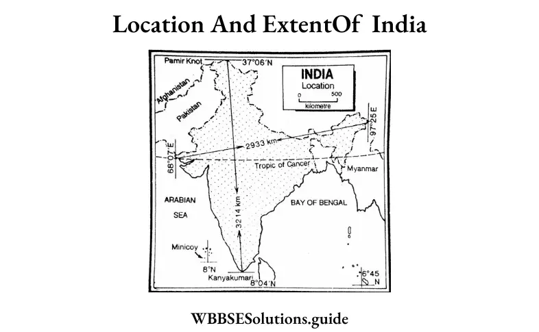
Question 24. The southernmost limit of India is Indira Point.
Answer: True

Question 25. The highest peak of the Nilgiri hills is Mt. Dodabetta.
Answer: True

Question 26. The desert of India is mainly situated in the state of Gujarat.
Answer: False

Question 27. Satpura is a block mountain of India.
Answer: True

Question 28. The western coastal plain receives heavy rainfall.
Answer: True

Question 29. Minicoy island is situated in the Manas Sarovar.
Answer: False

Question 30. The highest peak of India is Mt. Everest.
Answer: False

Question 31. Rajmahal hill is the highest part of the Ranchi Plateau.
Answer: False

Question 32. Satpura is a Block Mountain of India.
Answer: True

Question 33. The highest peak of Eastern Ghat is Mahendragiri.
Answer: True

“Class 10 Geography and Environment Physiography of India solutions WBBSE”

Question 34. Satpura consists of seven parallel ranges.
Answer: True

Question 35. Himalaya means abode of snow.
Answer: True

Question 36. Zoila is a pass of the Greater Himalayas.
Answer: True

Question 37. K2 is the highest peak of the Karakoram Range.
Answer: True

Question 38. Baltimore is a Glacier of the Karakoram.
Answer: True

Question 39. Khadars are the newer alluvial soil.
Answer: True

Question 40. Anairnudi is the highest peak of Nilgiri.
Answer: False

Question 41. Satpura is higher than the Vindhyas.
Answer: False

Question 42. Deccan trap is a intermontane plateau.
Answer: False

Question 43. Himalaya is an example of the oldest fold mountain.
Answer: False

Question 44. North-eastern hills of India are together known as Purbachal.
Answer: True

WBBSE Solutions For Class 10 Geography And Environment India - Physiography Of India

Class 10 Geography West Bengal Board India – Physiography Of India Fill In The Blanks Type:

Question 1. The highest mountain peak of South India is ______.
Answer: Anaimudi.

Question 2. The southernmost point of mainland India is ______.
Answer: Kanyakumari.

Question 3. ______ is the highest part of the Meghalaya Plateau.
Answer: Shillong.

Question 4. Mt.Trisul is in the ______ Himalaya.
Answer: Greater.

WBBSE Class 10 Geography Solutions

Question 5. ______ is a Glacier of the Karakoram Range.
Answer: Hesper.

Question 6. ______ is in between Himachal Pradesh and Tibet.
Answer: Sipki La.

Question 7. ______ Pass is in between Srinagar and Jammu.
Answer: Banihal.

Question 8. Jawahar Tunnel is an all-weather ______ to Srinagar Valley.
Answer: Tunnel.

Question 9. One mountain pass of J & K is ______.
Answer: Banihal.

Question 10. ______ plateau is part of the ancient Gondwanaland.
Answer: Deccan.

Question 11. The Eastern Coastal Plain of India lies along the coast of the ______.
Answer: Bay of Bengal.

Question 12. The Lakshadweep Islands lie in the ______sea.
Answer: Arabian.

Question 13. _______ is the highest peak in the Deccan.
Answer: Anaimudi.

Question 14. The northern plain of India was formed after the rise of the _______.
Answer: Himalayas.

Question 15. ______ was the sea from which the Himalayas rose up.
Answer: Tethys.

Question 16. ______ hills stand on the plateau of Meghalaya.
Answer: Garo.

Class 10 Maths Class 10 Social Science
Class 10 English Class 10 Maths
Class 10 Geography Class 10 Geography MCQs
Class 10 History Class 10 History MCQs
Class 10 Life Science Class 10 Science VSAQS
Class 10 Physical Science Class 10 Science SAQs

Question 17. Indian desert lies in the west of the ______ range.
Answer: Aravalli.

“WBBSE Class 10 Geography Physiography of India solved questions”

Question 18. ______ is the highest peak of the Himalayas in India.
Answer: Kanchenjungha.

Question 19. Eastern Ghats is also known as ______.
Answer: Malayadri.

Question 20. _______ is the highest peak of the western ghats.
Answer: Kalsubai.

Question 21. Luni is the only ______ drainage of western India.
Answer: Inland.

WBBSE Class 10 Geography Solutions

Question 22. Himalaya means abode of ______.
Answer: Snow.

India – Physiography Of India Very Short Answer Type:

Question 1. What is ‘TaS’ in Western Himalaya?
Answer: Lakes / Glacial Lake / Water body

Question 2. Name the largest salt lake of the Thar desert.
Answer: Sambar Lake is the largest salt lake in the Thar desert.

Question 3. What is Himadri?
Answer: Himadri is the highest mountain range of the Himalayas in the North. It has snow-topped mountain peaks.

Question 4. What is Rohi?
Answer: The patches of more fertile tracks in the Northern and Central parts of Rajasthan are locally called Rohi.

Question 5. Name the islands on the Bay of Bengal.
Answer: The Andaman and Nicobar Islands are on the Bay of Bengal.

Question 6. Name the group of islands on the Arabian Sea.
Answer: The Lakshadweep is on the Arabian Sea.

Question 7. Name a lake in Manipur Valley.
Answer: Logtak is a lake of Manipur Valley.

Question 8. Which one is the highest plateau in India?
Answer: The Ladakh plateau of Jammu and Kashmir is the highest plateau of India.

Question 9. Name the highest peak in India.
Answer: Mt. Kanchanjunga (8595 m).

Question 10. Name the longest river in India.
Answer: Ganga.

Question 11. Name the longest tunnel in India.
Answer: Jawahar Lai Nehru Tunnel.

Question 12. Name the highest peak of Satpura.
Answer: Mt. Dhupgarh.

Question 13. Name the highest peak of Nilgiri.
Answer: Mt. Dodabetta (2637m).

Question 14. Name the highest peak of Annamalai.
Answer: Mt. Anaimudi.

Question 15. Name the highest peak of the Western Ghats.
Answer: Mt. Kalsubai.

Question 16. Name the all-weather tunnel to Srinagar Valley.
Answer: Jawaharlal Tunnel.

Question 17. Name one mountain pass in Himachal Pradesh.
Answer: Sipki La.

Question 18. Name the highest peak of Aravali.
Answer: Mt. Gurusikha.

Question 19. Name the highest peak of South India.
Answer: Mt. Anaimudi.

Question 20. By what name the Lagoons in the Kerala Coast are called?
Answer: Kayal.

Question 21. What is the local name of the dunes in the Malabar Coast?
Answer: Teris.

Question 22. Name the highest peak of the Karakoram Range.
Answer: Mt. Godwin Austin.

Question 23. Name the desert of India.
Answer: Thar Desert.

Question 24. What is the meaning of the name Satpura?
Answer: Satpura means seven parallel ranges of mountains.

Question 25. What is the meaning of the word Himalayas?
Answer: Abode of snow.

Question 26. Where is Zozila Pass located?
Answer: The Zozila pass is in Ladakh.

Question 27. Where do you find the Baltora Glacier?
Answer: Baltora Glacier is in the Karakoram Range.

Question 28. What are Belts?
Answer: Belts are narrow strips of low-lying floodplains.

Question 29. What are Khadars?
Answer: The newer alluvial plains of the Ganga Plain are called Khadars.

“Physiography of India Class 10 WBBSE solutions and answers”

Question 30. Where are Northern Circars?
Answer: The eastern coastal plain extending from the mouth of Subarnarekha to the mouth of Krishna is known as Northern Circars.

Question 31. What are Ghats?
Answer: The Ranchi Plateau is deeply dissected around its edges giving rise to escarpments locally called Ghats.

Question 32. Name the highest peak of Gir Mountain.
Answer: Mt. Gorakhnath.

Question 33. What is the other name of the Eastern Ghats?
Answer: Malayadri Mountain.

Question 34. What are Duns?
Answer: Duns are the flat-floored structural valleys mainly found in the Himalayas, e.g. Dehra Dun.

Question 35. Name the glaciers of the Karakoram Range.
Answer: Baltora, Bistro, Hisper, and Siachen.

Question 36. How many divisions are there in the Himalayas (West to East)?
Answer: West to East, the Himalayas have three divisions, these are Western Himalaya, Central Himalaya, and Eastern Himalaya.

Question 37. How many divisions are there in the (North to South) Himalayas?
Answer: Four divisions-Tethys or Trans Himalaya, Greater Himalaya, Lesser Himalaya, and Outer Himalaya.

Question 38. How many divisions are there in the Eastern Himalayas?
Answer: Four divisions-Sikkim Himalaya, Darjeeling Himalaya, Bhutan Himalaya and Arunachal Himalaya.

Question 39. Name three important passes of the Himalayas.
Answer: Burzilla, Zojila and Karakoram Pass.

Geography Class 10 Solutions WBBSE

Question 40. Name the knot from which the Himalayas is originating.
Answer: Pamir knot.

Question 41. Which is the oldest mountain in India?
Answer: Aravalli Range.

Question 42. Name five peaks of the Greater Himalayas.
Answer: Nanga Parbat (8125 m.), Kamet (7756 m.), Nandadevi (7817 m.), Dhaulagiri (8172 m), Makalu (8481m).

Question 43. Name two mountain passes in Jammu and Kashmir.
Answer: Mt. Everest, Mt. Annapurna, Mt. Makalu, and Mt. Gouri Sankar.

Question 44. What is the name of the extension of the Himalayas in the eastern region?
Answer: Purbachal.

Question 45. Name the highest peak of the Nanga Range.
Answer: Mt. Saramati (3823 m).

Question 46. Name the hills and ranges of the Purbachal.
Answer: Mikir, Barail, Lushai, Patkoi, Naga Hills, etc.

Question 47. Name the hills of the Meghalaya Plateau.
Answer: Garo, Khasi, and Jaintia.

Question 48. Name the highest peak of Rajmahal Hill.
Answer: Mt. Pareshnath (1366 m).

Question 49. Name the highest peak of Annamalai Hill.
Answer: Mt. Annamalai (2695 m).

Question 50. Name the highest peak of the Eastern Ghats.
Answer: Mt. Mahendragiri (1500 m).

Question 51. Name the highest peak of Andaman and Nicobar Islands.
Answer: Saddle Peak. (750 m).

Question 52. How many islands are there in Andaman Island?
Answer: 200 islands.

Question 53. How many islands are there in the Nicobar Island?
Answer: 10 islands.

Question 54. Name one active volcano in India.
Answer: Barren Island.

Question 55. Name one coral island in India.
Answer: Lakshadweep.

Question 56. Name the longest glacier in India.
Answer: Siachen glacier on the Karakoram range.

Question 57. What do you mean by ‘Purvanehal’?
Answer: The Northeastern hills are also known as Purvanehal.

Question 58. Which lake has the only floating park in the world?
Answer: The Loktak lake lies between the Naga and Lushai Ranges.

Question 59. Name the highest peak of the Western Himalayan range.
Answer: Dapha Bum.

Question 60. What is the meaning of the word ‘Meghalaya’?
Answer: Abode of clouds.

Question 61. Name the highest peak of Meghalaya.
Answer: Mt. Shillong Peak.

Question 62. What is the group of Coral islands in India called?
Answer: Lakshadweep.

Question 63. Name the highest peak of the Vindhya Range.
Answer: Manipur.

Question 64. Amarkantak is the highest peak of which range?
Answer: Maikal Range.

Question 65. Name the highest peak of Nilgiris.
Answer: Dodabetta.

Question 66. Where is Nanga Parbat located?
Answer: Jammu & Kashmir.

Question 67. Where is Namcha Barwa located?
Answer: Arunachal Pradesh.

Question 68. Name the southernmost range of the Himalayas.
Answer: The Shiwalik Range.

Question 69. Name the mountain range located in the north of the Great Himalayas and having the highest peak in India.
Answer: Karakoram Range.

Question 70. Name the mountain range in the south of the Narmada River and parallel to it.
Answer: The Satpura Range.

Question 71. Name the mountain range in the north of the Narmada River and running parallel to it.
Answer: The Vindhya Range.

Question 72. Name the mountain range flanking the northeastern edge of the Malwa Plateau.
Answer: The Aravalli Range.

Question 73. Name the longest hill range of south India.
Answer: Western Ghats or Sahyadri.

Question 74. Name the Himalayan pass located in Himachal Pradesh and touching the Indo-China border.
Answer: Shipki La.

Question 75. Name the mountain pass in Jammu and Kashmir located at the Indo-China border.
Answer: Karakoram Pass.

Question 76. The one mountain pass in Arunachal Pradesh.
Answer: Bondi La.

Question 77. Name the gap in the Western Ghats which is used by rail link between Mumbai and Chennai.
Answer: BhorGhat.

Question 78. Name the southernmost gap in the Western Ghats.
Answer: Pal Ghat.

Question 79. Name any one pass located in Sikkim.
Answer: Nathu La or Jelep La.

Question 80. What do you mean by Indira Col?
Answer: Indira Col is the northernmost point of India at 37°6-north latitude. It is located at the strategic point at the northern border of Jammu and Kashmir where the boundaries of four countries — India, Pakistan, Afghanistan, and China meet.

Question 81. Name a plateau located in the north of the Vindhya Range.
Answer: Malwa Plateau.

Question 82. Name the plateau in the northeastern part of the Indian peninsula which is rich in mineral resources and through which the Damodar River flows.
Answer: Chotanagpur Plateau.

Question 83. Name the plateau continuous to the Himalayan ranges but belonging Peninsular plateau.
Answer: Meghalaya Plateau.

Question 84. Name the plateau formed by volcanic eruptions and rich in black cotton
Answer: Deccan Plateau.

Question 85. Name the plateau drained by the river Mahanadi and its tributaries.
Answer: Chhattisgarh.

Question 86. Name the coastal plain between Mumbai and Goa.
Answer: Konkan plain.

Question 87. Name the coastal plain between the Krishna and Cauvery rivers.
Answer: Coromandel.

“WBBSE Class 10 Geography Physiography of India chapter answers”

Question 88. Name the coastal plain of Kerala.
Answer: Malabar.

Question 89. Name the gulf on the coast of which Kandla port is located.
Answer: Gulf of Kuchchh.

Question 90. Which strait separates India from Sri Lanka?
Answer: Palk Strait.

India – Physiography Of India 2 Marks Questions And Answers:

Question 1. Where is Malnad region located?
Answer:

Malnad, literally meaning hilly country, is the portion bordering the Sahyadri having an average width of 3 km and a mean elevation of 1,000 m. it is dissected into steep hills and deep valleys. The northern and south-eastern portion of the Mysore (or Karnataka) plateau, an area of rolling plains and granite hills, is called Malnad.

Question 2. What is Dhrian? Where is it found?
Answer:

Dhrian:

Longitudinal dunes are known as Dhrian. It is found in the Thar desert.

Question 3. Name the oldest mountain range of India and the state where it is located.
Answer: The Aravalli is the oldest mountain range in India. It is located in Rajasthan.

Question 4. Which is the highest peak of the Himalayas situated in India? Where is it located?
Answer: Kanchenjunga (8,598 m) is the highest mountain peak in India located in the Himalayan Range in Sikkim.

Question 5. What is Purbachal?
Answer:

Purbachal:

The branches of the Himalayas in the northeastern region are together known as Purbachal. The whole northeast hilly region is included in this region.

Question 6. Where is the Eastern Ghat located? Name its highest peak.
Answer: Eastern Ghat is located on the Eastern coast. Mahendragiri is its highest peak.

Question 7. Name one mountain pass in the Western Himalayas and one mountain pass in the Eastern Himalayas.
Answer: The Burzil Pass (4,199 m) lies over the Great Himalayas of Western Himalayas. The communication is between Srinagar and Gilgit. Nathula La in Sikkim of Eastern Himalayas. The communication is between Sikkim and Tibet.

Question 8. What is the significance of the name Himalayas?
Answer: Hima means snow and Alaya means home. The vast snow fields attracted the attention of ancient Indian sages who rightly named it Himalaya.

Question 9. Name three hills of the Meghalaya plateau.
Answer:

The three hills of the Meghalayan plateau are:

1. Garo,
2. Khasi and
3. Jayantia hills.

Question 10. Compare and contrast the East Coast with the West Coast of India.
Answer:
 India - Physiography Of India east and west coast

Question 11. Why is the Himalayan mountainous region prone to earthquakes?
Answer: Himalayas is extended from East to West in the north of India. It is a young fold mountain. The land is not yet balanced here. The geologists believe that the procedure of the formation of mountains is still not terminated. Hence, the balance of the earth is going on slowly. So, the Himalayan mountainous region is prone to earthquakes.

Question 12. Where are the Siwalik ranges located?
Answer: Siwalik Range is the southernmost range of the Himalayas. This range extends from the Potwar Plateau in the West to the Brahmaputra valley in the East.

“Class 10 Geography Physiography of India WBBSE notes”

Question 13. Mention the extent of the Himalayas in India.
Answer: The Himalaya is extended from Nanga Parbat in Kashmir in the West to Namcha Barwa near Arunachal Pradesh in the East.

Question 14. State the origin of the Himalayas according to plate tectonic theory.
Answer: According to the theory of ‘Plate Tectonic’, the crust of the earth comprises six plates. All plates are moving. The two plates, the ‘Indian peninsular plate’ and ‘Siberian plate’ collided with each other. As a result, the fringe of the Indian Peninsular Plate folded forming the Himalayan Mountains.

Question 15. Name three mountain ranges of the Deccan plateau.
Answer:

The Deccan plateau comprises of three important mountain ranges:

1. Satpura- Mahadev mountain range,
2. Ajanta and
3. Western Ghats.

Question 16. Where is the ‘Nanga Parbat’ located?
Answer:

‘Nanga Parbat’ is situated in North Kashmir on the Great Himalaya range. In the western region where the Indus bends and enters Pakistan, stands the Nanga Parbat (8,126 m.)

Question 17. Floods are frequent in the Brahmaputra Valley. Why?
Answer:

Floods are frequent in the Brahmaputra Valley

Brahmaputra Valley is situated between the Himalayas and the Meghalaya Plateau. The region receives heavy rainfall throughout the year, so heavy rainfall causes floods. The river Brahmaputra along with its tributary deposits plenty of silt in the river bed thereby making it shallow and causing floods. The river Brahmaputra has taken a zigzag course causing a flood. The region is prone to earthquakes and floods.

Question 18. Name the highest peak and the longest river of the Deccan.
Answer: The highest peak of the Deccan is Mt. Anaimudi. The longest river of the Deccan is Godavari.

Question 19. Name the highest peak of Nilgiri and name the highest peak of the Satpura Range.
Answer: The highest peak of Nilgiri is Mt. Dodabeta. The highest peak of Satpura is Mt. Dhupgarh.

Question 20. Name two famous valleys of Himachal Pradesh.
Answer: Kulu and Kangra Valleys.

Question 21. Divide Gujarat Plains.
Answer:

Gujarat plains are divided into two parts:

1. Kuchchh peninsula and
2. Kathiawar peninsula.

Question 22. Name three mountain passes of the Himalayas.
Answer:

The three mountain passes of the Himalayas are:

1. Banihal pass,
2. Zoji La pass and
3. Shipki La pass.

Question 23. Name the mountain gaps or passes of the Western Ghats mentioning their location.
Answer:

The important gaps or passes in the Western Ghats are:

1. The Thai Ghat,
2. The Bhor Ghat in the eastern part of Mumbai and
3. Pal Ghat in the South of the Nilgiri hills.

Question 24. Name the glaciers of the Himalayan range.
Answer: Mountain peaks are covered by perpetual snow. Himalaya is the home of many glaciers such as Gangotri and Yamunotri on the Himalayas, Siachen, Great Baltora and Hesper on the Karakoram range.

Question 25. Name some of the beautiful valleys of the Himalayas.
Answer: The important valleys of the Himalayas are the valley of Kashmir, the Valley of Kulu and Manali, Dehradun, Kangra Valley, and so on.

Question 26. What do you mean by “Dun”?
Answer:

Dun: Broad longitudinal valleys lying between the main Himalayas and the Shiwalik range formed by the deposition of materials brought down by Himalayan rivers, are called ‘duns’.

Example: Dehradun

“WBBSE Solutions for Geography Class 10 Physiography of India MCQs and answers”

Question 27. Mention the divisions of the Himalayas.
Answer:

Divisions of the Himalayas:

From West to East: The Himalayas can be broadly divided into three divisions:
1. The Western Himalayas,
2. The Central Himalayas,
3. The Eastern Himalayas.

From North to South: The Himalayas can be divided into four divisions:
1. The Trans or Tethys Himalayas,
2. The Greater Himalayas,
3. The Lesser Himalayas,
4. The Outer Himalayas or Siwalik Rang

WBBSE Class 10 Geography Chapter 5 Question Answer India – Physiography Of India 3 Marks Questions And Answers:

Question 1. The Himalayan region is sparsely populated. Why?
Answer:

The Himalayan region is sparsely populated because of the following reasons:

1. Rugged surface,
2. Harsh climate,
3. Lack of .fertile agricultural plain land,
4. Lack of transport and communication. Railways are absent here,
5. Absent of large-scale industry,
6. Lack of raw materials: though the region is rich in minerals, because of the rugged surface and lack of roadways, it is very difficult to explore them.
7. Earning of living is not easy here,
8. Lack of wide market.

Question 2. Kashmiris called ‘Heaven of the Earth’-Why? Or, Tourism has been developed in Kashmir- Explain why.
Answer:

Kashmiris called ‘Heaven of the Earth’

Kashmir lies in the mountain bed of the western Himalayas. The natural scenes are very attractive here. The peaks covered by sheets or blankets of snow, swift-flowing rivers, beautiful waterfalls, colourful flowers here and there, the sound of birds, and many more scenes make Kashmir like heaven. Hence, due to these attractive natural scenes, it is called “Heaven of the Earth”. Due to these factors, people come here from distant places to view and enjoy the natural beauty of Kashmir. Hence, it is a tourist abode place and many hotels are formed here.

Question 3. The Himalayan mountain chain is prone to earthquakes Why?
Answer:

The Himalayan mountain chain is prone to earthquakes

Himalayan mountains are newly formed fold mountains. Here the mountain-building activity has not yet been done completely. There are certain movements in the surface to stable the unstable equilibrium. Hence these movements are responsible for the origin and the occurrence of earthquakes. That is why the Himalayan mountain chain is prone to earthquakes.

Question 4. Heavy industries are not developed in the Himalayan mountainous region. Why?
Answer:

The region of the Himalayas mountains has a scarcity of heavy industries due to the:

1. Absence of transport system The Himalayan region is mountainous and hard. So there is the absence of a Railway system. The rivers of this region are very swift flowing so they are not navigable. Hence, the transport system of this region is not developed leading to a scarcity of heavy industries.
2. Lack of raw materials As the surface is not fertile, there is no development or growth of agriculture. Due to lack of facilities, minerals are not mined. Hence agro-based or mineral-based industries are not developed due to a lack of necessary raw materials.
3. Lack of cheap labour due to lack of survival conditions here the population is low. Hence cheap and skilled labour is not available.
4. Absence of power stations Lack of coal and hydel power stations is another cause for an industry to develop in the Himalayan regions.

Question 5. Write in short about the Brahmaputra Valley.
Answer:

Bramhaputra Valley: The Brahmaputra valley has been built up by the aggradational work of the Brahmaputra valley and the lower Brahmaputra valley. A large number of isolated hillocks of monadnocks on both banks of the river right from Tezpur and Mikir Hills to as far West as Dhubri is another interesting feature of this valley.

Another significant physical characteristic of Brahmaputra valley is that the river itself is highly braided because of its very low gradient. There are a large number of river islands in it. Majuli is the largest river island in the world covering 929 sq. km. Brahmaputra valley is covering an area of 56,500 sq. km of the state of Assam. Floods are very frequent here because of the shallow river beds and heavy rainfall in this region. A huge deposition of silt has made the river bed shallower.

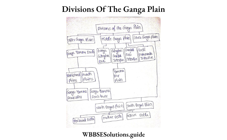
Question 6. Name the divisions of the Ganga plain.
Answer:

Divisions of the Ganga plain


WBBSE Solutions For Class 10 Geography And Environment India - Physiography Of India Divison Of The Ganga Plain
Question 7. What is Deccan Trap?
Answer:

Deccan Trap

A vast area extending from the Arabian sea coast in the West as for as Nagpur and Gujarat in the North to Belgaon in the South is covered with a thick mantle of plateau mainly made of Basalt, called the Deccan Trap. It is a lava plateau. The mechanical weathering has given rise to flat-topped hills flanked by terraces or steps. The word trap is used to describe its structure because the trap is a Swedish word meaning steps or stairs.

“Physiography of India WBBSE Class 10 question answers PDF”

Question 8. Name the three mountain passes of the Himalayas.
Answer:

Mountain passes are the narrow gaps in mountain ranges. The three important mountain passes of the Himalayas are

(1) Banihal pass,
(2) Zojila pass and
(3) Shipki La pass.

Class 10 Geography West Bengal Board

Question 9. Name the glaciers of the Himalayan range.
Answer:

Glaciers of the Himalayan range

The mountain peaks are covered by perpetual snow. Himalaya is the home of many glaciers; such as Gangotri and Yamunotri on the Himalayas, Siachen, Baltoro and Hisper on the Karakoram range.

Question 10. Name some of the beautiful valleys of the Himalayas.
Answer:

The important valleys of the Himalayas are the valley of Kashmir, the valleys of Kulu and Manali, Dehradun, Kangra valley and so on.

Question 11. Name three mountain gaps or passes of the Western Ghats mentioning their location.
Answer:

The important gaps or passes in the Western Ghats are:

(1) The Thai Ghat and
(2) The Bhor Ghat in the eastern part of Mumbai, and
(3) The Pal Ghat in the south of the Nilgiri Hills.

Question 12. Describe the relief of the Kashmir Himalayas and Himachal.
Answer:

T he relief of the Kashmir Himalayas and Himachal

1. The Kashmir Himalayas is located in the state of Jammu and Kashmir. The mountains of the region from South to North are Jammu and Punch hills of the Zaskar Range constitute the Great Himalayas. To the North of the Himalayas, there is the deep gorge created by the river Indus. To the extreme North of Jammu and Kashmir lies the Karakoram mountain with its highest peak Godwin-Austin or K.
2. The Himachal Himalaya includes the Siwalik mountain in the South, to its North lie the Middle Himalaya which include the Dhaoladhar, Pirpanjal, Nagtibba and Missouri ranges. Further North lies the Great Himalayas.

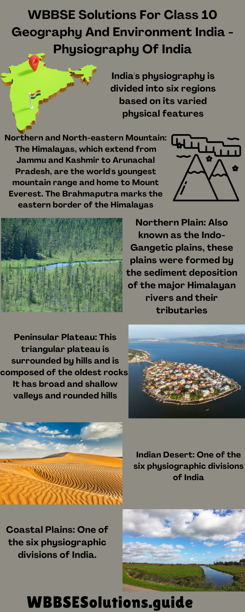
Question 13. Name the physiographic divisions of India.
Answer:

India can be divided into the following physiographic divisions

1. Northern mountain.
2. Plains of North India.
3. The Peninsular Plateau.
4. Coastal Region.
5. Islands.

Question 14. Name the three parallel ranges of the Himalayas and state some typical characteristics of each.
Answer:

The three parallel ranges of the Himalayas are

(1) Great Himalayas or the Himadri: The northernmost and loftiest range is called Himadri. Mount Everest is the highest peak in the world located in this range.
(2)Middle or lesser Himalayas other Himachal: All the important hill stations belong to this range such as Dalhousie, Dharmshala, Shimla, Mussoorie, Nainital and Darjeeling.
(3)Outer Himalayas or the Shiwalik Ranges: These ranges are made of unconsolidated river deposits and are prone to earthquakes and landslides.

Question 15. Where is the Assam Valley? Why is it so flood-prone?
Answer:

Assam Valley is flood-prone: The Assam valley extends from Saidya in the east to Dhubri in the west where the Brahmaputra turns southwards and takes the western edge of the Garo hills and Meghalaya. The Brahmaputra floods normally begin in May with the thawing of snow in Tibet and the Eastern Himalayas and they are aggravated by the heavy monsoon rains from June to September. The rise in the level of water in the Brahmaputra prevents the water of the tributary streams from entering it. The blockade to the rise of water- levels in tributary streams causes widespread floods. The region is in the earthquake zones. Because of the inside movements, sometimes the riverbed rises causing food. The river Brahmaputra has taken a zigzag course. Because of the increase of water the river breaks through the narrow margin between two bends and causes floods.

Question 16. Write the significance of the coastal plains of India.
Answer:

Significance of the Coastal Plains of India:

(1) The deltas of Mahanadi, Godavari, Krishna and Kaveri on the Eastern coastal plain have rich fertile soil. They produce crops like rice, sugarcane, spices, etc. and support our agricultural economy,
(2) The ports of Mumbai, Marmagao, Cochin, Chennai, and Vishakhapatnam help to promote our international trade,
(3) The flat coastal plains present ideal sites for settlements,
(4)Marine fishing is an important occupation of the people of coastal plains,
(5) The deltas of Krishna, Godavari, Kaveri, etc. have been explored for oil and natural gas extraction. They can thus become potential sources of mineral oil.

Question 17. Write the significance of the islands of India.
Answer:

The Islands:

(1) The islands of Andaman and Nicobar provide valuable timber like mahogany, ebony, teak, etc.
(2) Variety of spices are also produced on these islands which are mainly exported,
(3) The extraordinary beauty of these islands attracts tourists from far and wide. They thus help to develop the tourism industry also.

Question 18. Difference between Bhabar and Tarai:
Answer:

Difference between Bhabar and Tarai:

Bhabar   Trai
1.   It lies along the foot of the Shiwaliks from the Indus to the Tista. 1.    It lies to the south of the Bhabar and runs parallel to it
2.    It is 8 to 16 km wide. 2.    It is 20 to 30 km wide.
3.    It comprises pebble-studded rocks 3.   It is composed of comparatively finer alluvium and is covered by forests.
4.    Due to the porosity of the rocks, the streams disappear and flow underground. 4.    The underground streams of the bhabar re-emerge in the surface and give birth to marshy areas.
5.    This region is not much suitable for agriculture. 5.   Most parts of the terai area are reclaimed for agriculture.


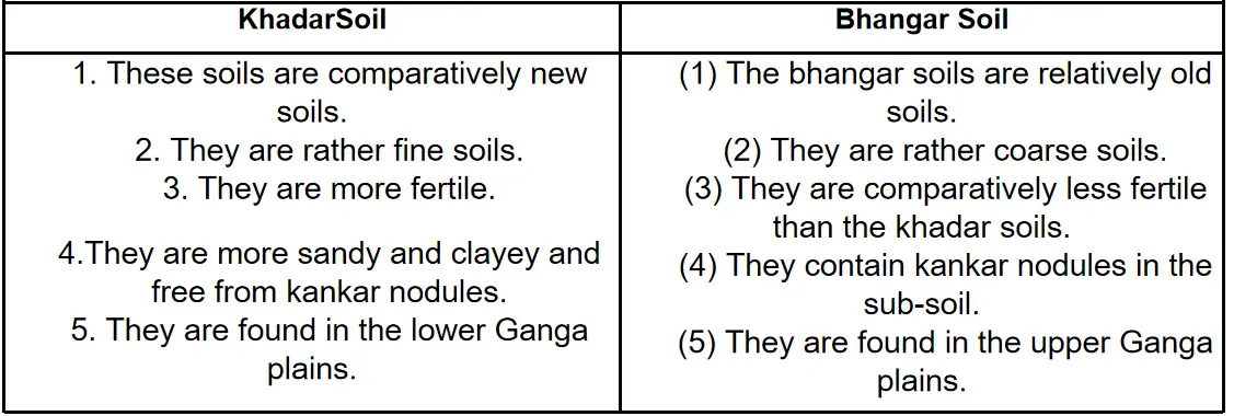
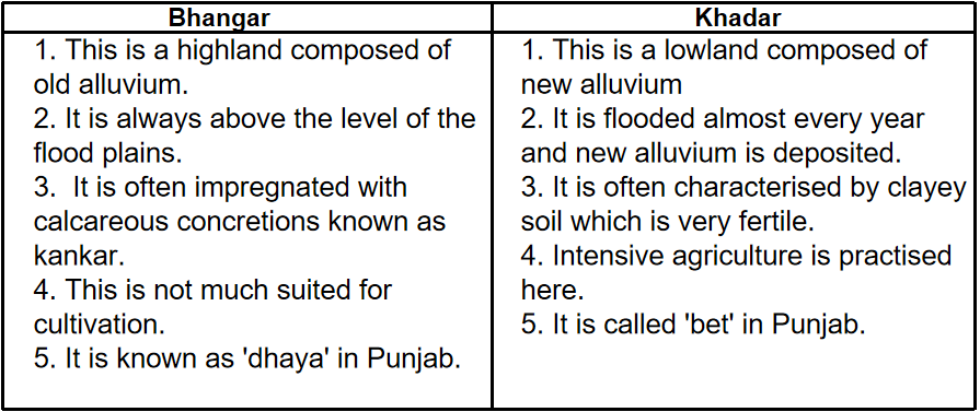
Question 19. Difference between Bhangar and Khadar:
Answer:

Difference between Bhangar and Khadar:

 India - Physiography Of India Bhangar Khadar

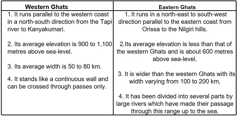
Question 20. Difference between Western Ghats and Eastern Ghats.
Answer:

Difference between Western Ghats and Eastern Ghats:

 India - Physiography Of India western ghats and eastern ghats

Question 21. Discuss the features of the Deccan plateau of India.
Answer:

The Deccan Plateau has the following features:

(1)The northern part of the Deccan Plateau has the Maharashtra Plateau composed of lava sheets and displays flat and steep hills, ridges and shallow, broad valleys.
(2)The Andhra (Telangana) Plateau has hilly and forest-covered northern parts and plain land with small hills and minor depressions in its southern portion.
(3)The Karnataka Plateau forming the middle parts of the Deccan Plateau rises to the southwest and joins the Nilgiri Hills. Its northern area, less than 600 m in height, has the Krishna river flowing through its east. The southern area of the Karnataka Plateau is higher with an average elevation of 600 to 900 m. It has the Cauvery river running through its southeast.
(4)The Deccan Plateau displays a sudden narrowing of land below the Karnataka Plateau. Here, it comprises uplands made by the hills of Palni, Nilgiri, Cardamom and Annamalai. It is bordered on its sides by the Tamil Nadu and Kerala plains.

India – Physiography Of India 5 Marks Questions And Answers:

Question 1. Give a brief account of the physiography of the Western Himalayas of India.
Answer:

Physiography of the Western Himalayas of India

Physiography of Western Himalaya: According to SirS. Burrard, the Himalayas are generally regarded as consisting of the following four main sections which are separated from one another by the gorges of rivers which pass through them:

(1)The Punjab HimalayasThis section between the Indus and the Sutlej is known as the Punjab Himalayas. It is also called Jammu-Kashmir and Himachal Pradesh Himalaya because most of this section is located in these two states. This section is 560 kilometres long. The important ranges of this section are the Ladakh, the Pir Panjal, the Dhaoladhar and the Zanskar. The Zoji La pass is at an altitude of 3,444 metres above the sea-level.
(2)The Kumaon Himalayas This section runs for a distance of 320 kilometres between the Satluj and the Kali rivers. This is higher than the Punjab Himalayas. Great rivers like Ganga and Yamuna have their sources in the Kumaon Himalayas.
(3)The Upper HimalayasThis is situated between the Kali and the Tista rivers and is 800 kilometres long. This is the highest part of the Himalayas where lofty peaks like the Mt. Everest, the Kanchenjungha, the Dhaulagiri, the Annapurna, the Makalu, etc. are located. The flat Kathmandu valley is also situated in the Nepal Himalayas.
(4)The Assam HimalayasIt extends for a distance of 720 kilometres between the Tista and the Dihang (Tsangpo-Brahmaputra).

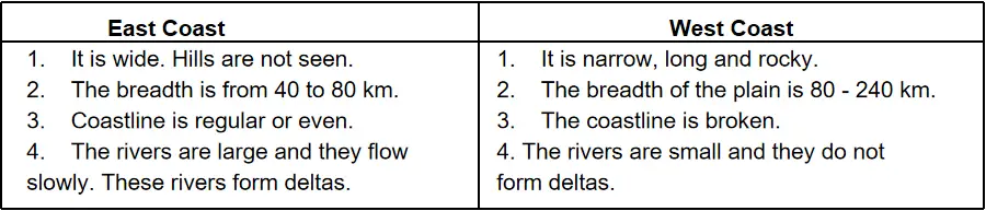
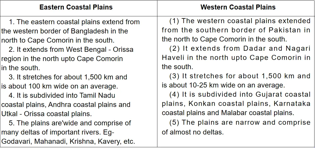
Question 2. State the physiographic differences between the Eastern and Western Coastal Plains of India.
Answer:

Differences between the Eastern and Western Coastal Plains of India:

eastern and western plains

Question 3. Discuss the origin of the Himalayas.
Answer:

Origin of the Himalayas:

Birth of the Himalayas: The recent geological research and observations provide new insight into the mechanism of Plate Tectonic Theory which led to the formation of the Himalayas.

Plate Tectonic Theory: The observations show a major reorganisation of the plate around the Indian Ocean about 50 million years ago and this is interpreted as the effect of the collision between Indian and Eurasia plates. In this process continental crust, squeezed by the collision, was then shortened by about 2,600 km. Before the continental mass of India collided with continental mass of Eurasia, the thinner oceanic crust of the then Tethys Sea to the North of India slipped quietly underneath the Eurasian crust. The collision which took place roughly 50 million years ago is responsible for the upthrusting that has produced the Himalayas.

Continental Drift Theory: According to Alfred Wegner, hundreds of million years ago all the land surfaces were joined together to form a massive continent. This supercontinent was known as Pangea. Due to certain factors, this Pangea was broken and each piece moved away from the other and ultimately formed the continents. But as the fragments of land moved away from their mother form, soon all of them approached each other and that resulted in the formation of fold mountains.
Contraction Theory: Due to continuous heat radiated from the interior of the earth the contraction process caused the outer surface to be crumbled like a skin of a dried apple. These formed the fold mountains.
Geosyncline Theory: According to this theory, the Himalayas are coming out of a sea called Tethys. Because of tremendous pressure, the sedimentary rocks of this Tethys Sea got folded and uplifted and thus created the Himalayas.

Question 4. Classify and describe Himalayas from East to West. Or, Describe the regional divisions of Himalayas.
Answer:

Regional Division The Himalayas have been divided into three regional divisions, they are:

Western Himalayas They are again sub-divided into the following heads:
(1) Kashmir Himalayas It is located in the state of Jammu & Kashmir. It consists of Zanskar Range, Ladakh Range, etc. The Great Kashmir Valley lies in this region. The highest peak of India, K? (8,611m) & the highest plateau of India, Ladakh Plateau are
located here.
(2) Himachal Himalaya It is located from South: East of Jammu & Kashmir and enters in Himachal Pradesh. The Dhauladhar Range, the Pirpanjal Range, Nagtiba Range, Mussorie Range lie here.
(3) Kumaun Himalayas: The Himalayan stretch along the North of the U.P. are called Kumaun Himalayas. The region consists of mountain peaks like Nanda Devi (7,817m), Gangotri (6,614m), Kedarnath (6,990m), etc.

Central Himalayas: Central Himalayas are located in Nepal. Its highest peak is Mt. Everest which is the world’s highest peak.

Eastern Himalayas: This region can also be sub-divided into 3 regions
(1) Sikkim: Darjeeling Himalayas It is enclosed between Singalila & Dankhya Ranges. Kanchanjungha is situated in the Sikkim. On the southwestern corner of the region lie Darjeeling Himalayas.
(2) Bhutan Himalayas: The relief in this region is very rugged. The highest peak in this region is Chomolahari (7,314m).
(3) Assam or Arunachal Himalayas: This part of the Himalayas comprises several fertile valleys like Kamla valley. The Shiwalik Himalayas are very narrow here. Namcha Barwa is located in this region. The whole region is dissected by numerous rivers like Dibang, Kamla, Dihang and Subansiri.

Geography Class 10 Solutions WBBSE

Question 5. Compare and contrast the east coast with the west coast of India. Or, Draw a comparison between the eastern coastal plains and the western coastal plains.
Answer:

East Coast West Coast
1.  Width
1. It is wider, from 80-20 km. 1. It is narrow, from 40-80 km.
2. Topography
2. Coastline is regular and compact. 2. Coastline is broken in many places.
3. Neighbouring Sea
3. Coastal plains are washed by the Bay of Bengal. 3. Coastal plains are washed by the Arabian sea
4. Division
4. It is divided into Coromandai coast, Northern Circar, Utkai coast, and Contai coast 4. It is divided into the Konkan coast, Kathiawar coast, Kutchchh coast, Kanarese coast and Malabar coast
5. Rivers and their movement
5. The rivers are large and flow slowly. 5. The rivers are small and they flow swiftly.
6. Rainfall
6. Receives less rainfall but twice in a year 6. Receives very heavy rainfall but once a year.
7. Fertility
7. The soil is very fertile so agriculture is productive. 7. The soil is less fertile so agriculture is not so productive
8. Deltas
8. The rivers have a delta on their mouth 8. The rivers do not form a delta in their mouth.
9. Development
9. Moderate economic development. 9. Much economic development
10. Population
10. Density of the population is very high 10. Density of the population is low except southern region


Question 6. State the importance of the Himalayas.

Answer:

The social, financial, cultural and political conditions of India are affected by the Himalayas. The importance of the Himalayas are:

(1)Natural Barrier Himalayas act as a natural barrier to protect India from foreign invasion or foreign attacks.
(2)Source of Rivers Himalayas are mainly covered by snow. Hence it originates many rivers which are useful for humans and animals, e.g. Ganga, Yamuna, etc.
(3)Effect on AgricultureAs a mountainous region it is not suitable for agriculture. But terraced farming is practised on slopes and rice, tea, wheat, fruits are grown here.
(4)Production of H.E.P.The rivers originating from the Himalayas are very suitable for hydroelectric power.
(5)Rich wealth of Natural Vegetation Himalayas have nice forest cover. From these forests, wood of high quality can be obtained.
(6)Mineral Resources Himalaya is also known as a ‘storehouse of minerals’. The rocky part of the Himalayas is rich in minerals.
(7)Climatic influence
1. It prevents the cold winds of Central Asia to entering India. Hence it saves the people of India from severe cold.
2. It stops the southwest monsoon winds to cause heavy rainfall in northern India.
(8)Tourist abode places Having high elevation Himalayas are tourist attractions. The Jammu and Kashmir region and the Darjeeling region are famous.

Question 7. Write about the importance of the Great plains in the life of the Indian people.
Answer:

The importance of the Great plains of India is the following

1. Fertile Land This plain is very fertile. Hence, the agriculture, and transport system is well-developed here.
2. AgricultureThe northern plain is an agricultural region (except the Rajasthan plains). Large amounts of rice, jute, sugarcane, wheat, cotton, pulses, oilseeds, etc. are produced. Hence this region is called the Granary of India.
3. Transport Facility It is a plain region, hence, roadways and railways are also navigable. Thus, while India is connected with this part.
4. Irrigational Facility: The surface is soft, so wells are made here. The perennial rivers are always ready to provide water for irrigation.
5. Dense population The population density is the highest in this region. India’s 45% population is inhabited here. Thus many large cities have grown in this plain, e.g. Delhi, Agra, Lucknow, Patna, Calcutta, Varanasi, etc.
6. Development of Industries There are many industries located here due to the advantages of communication, raw materials, cheap labour, etc. The major industries are Sugar Industry, Textile Industry, and Jute industry which is mainly agro-based industries.
7. Centre of Civilization and Culture From ancient times these plains are the centres of civilization and culture. Harappan civilization, Gangetic valley civilization, etc. are located here. Many pilgrimages are also located here.

Question 8. Describe the importance of the Deccan plateau region.
Answer:

The importance of the Deccan plateau region are

1. This plateau is an important source of iron ore, coal, limestone, copper, manganese and other rich minerals. The north-eastern part of this plateau forms the Chotanagpur region and it is very rich in mineral resources and is, therefore, called the Storehouse of minerals in India.
2. The valleys of many rivers of the plateau produce cotton, rice, groundnut, onion, sugarcane, oranges, grapes and various other agricultural crops.
3. Easy availability of agricultural and mineral raw materials have helped in setting up many industries.
4. The rivers of the plateau are ideal for hydel power generation.
5. Another important resource of the plateau is the dense forest.
6. The natural beauty of this region has helped in the development of many tourist centres, e.g. Mount Abu in the Aravalli, Panchmari in the Mahadev hill, and Ootacamand in Karnataka.

Question 9. Classify the Himalayas from North to South and mention its characteristics.
Answer:

The Himalayan range is the loftiest mountain range in the world with an average elevation of 5600 metres. The Himalayan mountain chain, all along its longitudinal axis, is arranged into four main series of parallel ranges.

From the North to the South these mountain ranges are:

1. Tethys Himalayas,
2. Great Himalayas or Himadri,
3. Middle Himalayas or Himachal and
4. Siwaliks.

1. Tethys Himalayas: It is located farthest to the North; it gradually merges with the Tibetian plateau further North. The average height of the mountain lies between 5500-6000 metres. The second-highest mountain peak of the world and the highest mountain peak of India, namely K2 (Mt. Godwin Austin) stands here. A large number of glaciers are found along the southern face of the Karakoram.

2. Great Himalayas or Himadri: South of the Tethys Himalayas stretches this high mountain range with an average height of 6000 metres, known as the Great Himalayas or Himadri. It is covered with snow throughout the year. In this range of mountains, lofty peaks like Mount Everest or Sagarmatha (highest peak in the world, 8848 m), Kanchenjunga (8598 m), Dhaulagiri (8172 m), Nanga Parbat (8126 m) and Nanda Devi (7818 m) are all found. There are also many glaciers in this region.

3. Middle Himalayas or Himachal: This range has an average elevation of about 3000 metres and is covered with coniferous trees like spruce, fir, deodar, pine and willow. Some of the mountains here are Pir-Panjal, Dhauladhar, NagTiba and Mussorie range. Most of the important hill stations of India like Dalhousie, Shimla, Dharmshala, Mussorie, Nainital and Darjeeling are found here.

4. Siwalik Range or Outer Himalayas: BO lakh years ago, the 3rd stage of mountain building caused the Tethys, Himadri and Himachal Himalayas to rise up further. This was followed by an ice age. Large glaciers started eroding the Himalayas extensively. The eroded materials were deposited at the foot of the mountain. The deposits comprised of stones, boulders, pebbles, etc. Nearly 10 lakh years ago, during the 4th stage of mountain building, these unconsolidated materials were lifted up to form the Siwalik range. The average height of the Siwaliks vary between 600 to 1500 m. Its width varies from 10 to 50 km. Thereafter, the top of the Siwaliks started sinking slowly to the north to merge with the river valleys in the mountain. These are called Duns. These Duns are densely populated, e.g. Dehradun.

Question 10. Write the significance of the plains of northern India.
Answer:

Significance of the Plains of Northern India:

The plains of Northern India include the lowlands of three major rivers – the Ganga, the Brahmaputra and the Indus together with their tributaries. They occupy one-fifth of the area but support half the population of South Asia. These plains are the core area of its political, economic and cultural activities. These plains extend for 3,200 kilometres between the mouths of the Ganga and the Indus, along the mountains. The plains have a width of about 150 to 300 kilometres.
The longitudinal extent from the banks of the Ravi and the Sutlej to the Ganga delta alone is of 2,400 kilometres.

The plain is 280 kilometres wide near Allahabad and 160 kilometres wide near the Rajmahal Hills. It is narrowest in Assam varying between 90 and 100 kilometres. It is believed that the plains were once an area of the Tethys sea and were formed by the gradual filling of an initial marine depression by the sediments brought down by the Indus, the Ganga, the Brahmaputra and their tributaries. However, the infilling has not been homogenous as there are differences in the depth of the alluvium between their basins. There are differences in local relief over the entire plains from Sind to Assam. Thus, each segment of the plain has its own distinctive features.

Sub-Division of Plains: On the basis of regional characteristics, the Great Plains can be sub-divided into the following areas:
The Punjab Plains: With a distance of 640 km from northeast to south-west and 300 km from west to east, these flat plains occupy 1.75 lakhs sq km. Most of it lies in Pakistan. In India, these plains lie Punjab, Haryana and Himachal Pradesh. A significant feature of these plains is the doabs of the five tributaries of the Indus-Jhelum, Chenab, Ravi, Sutlej and Beas. In fact, Punjab derives its name from these, i.e., the land of five rivers. The watershed of the Aravalli Hills separates these plains from the Ganga Basin.

The Rajasthan Plains: These include the Marusthali or the Great Indian Desert. It is a sandy desert and is surrounded by the Sutlej in the northwest, the Aravalli range in the east, the Indus Valley in the west and the Rann of Kutchchh in the south. These plains extend over the northwest India (Rajasthan desert) and eastern Pakistan. They include the Rajasthan Bagar which is a semi-arid plain in the eastern side of the desert. Cultivation is done in small patches in this area with water provided by small streams which originate from the Aravalli during the rainy season. These fertile tracts are known as Rohi.

The only significant and largest river is Luni. The area north of Luni is a sandy plain. There exists an area of inland drainage on the north of the Luni basin. This is because the rivers of the area do not have sufficient water to reach the sea and dry up or disappear into the sand. These plains are dotted with a number of salt lakes on the eastern edge of the desert, such as the Sambhar, Kuchaman and Didwana. The Sambhar lake is the largest lake which lies on the border of Jaipur.


WBBSE Solutions For Class 10 Geography And Environment India - Physiography Of India plains of the north india

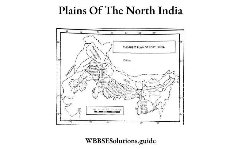
The Ganga Plains: These plains lie in Uttar Pradesh and Bihar. They consist of a number of regions, i.e., the Ganga-Yamuna doab, Awadh Plains and Mithila Plains. These plains have been formed by sediments brought down by the rivers Ganga, Yamuna, Ghagra and their tributaries. Both the bhabarand terai belts are well-formed in the Uttar Pradesh plain. The Ganga Plain of UP merges with the deltaic plain in Bengal through a transitional zone lying in Bihar.

The Brahmaputra Plains: These low-level plains extend in Assam for about 640 kilometres with a width of 90 to 100 kilometres. They have been formed by deposits from the Brahmaputra river and its tributaries and are bordered by high mountains. The small, meandering streams of the north from marshy areas. In some places on the plain, many steeply-rising hillocks are found. Besides, there are a number of riverine islands including Majuli, which is the largest river island in the world.

Question 11. Describe the physiography of Kashmir.
Answer:

Physiography of Kashmir: The most picturesque and densely populated part of the Kashmir Himalaya is the valley of Kashmir. It occupies the site of an ancient lake which was filled up. The valley is enclosed by a ring of mountains extending from Pir Panjal in the south and Himadri in the north. It extends from southeast to northwest for a distance of 150 km with an average elevation of 1,700 m and a width of 80 km.

The valley is traversed by north-flowing Jhelum which rises from the southern end of the valley from a spring at Verinag, meanders for 130 km north-westwards as far as the Wular Lake and then flows westwards. Fringing the river bank lies a flat plain dissected into terraces called Karewas. Some of these karewa terraces, dry and treeless, depending on snow and rain for their cultivation. Others are irrigated streams and produce crops like rice, maize and saffron. There are seven beauty spots. Gulmarg is one of them. A grassy valley, rich in flowers, lies on the northern slope of the Pir Panjal. From Gulmarg, a fine view of Nanga Parbat, from where the crest of the Great Himalayas in Kashmir starts, can be seen. Srinagar is the heart of the Kashmir Valley. It is 1893 m above sea level. Dal Lake near Srinagar is another beauty spot.

“WBBSE Geography and Environment Physiography of India solutions PDF”

Question 12. Describe the peninsular plateau region of India.
Answer:

Peninsular Plateau Region of India: The plateau has an elevation of 600 to 900 m with an area of 1.6 million sq. km. It is the largest and the oldest of all the physiographic divisions. Its northwest limit is marked by the Aravalli range and its northern extreme has the raised Bundelkhand Plateau. At its western and eastern ends are the Western Ghats and the Eastern Ghats respectively. The plateau is largely a stable terrain though volcanic eruptions have occurred in some areas of northwest Deccan.

The plateau land can be divided as follows:
The Central Plateaus: The upland of central India with the Ganga to its north has the Kaimur-Maikal range to its east, the Aravallis and Kutch to its west, and the Vindhya and Satpura ranges to its south. The Central Plateaus comprise :
1. The 250-500 m high Mewar upland is composed of shales, limestones and sandstones.
2. The 100 to 300 m high Bundelkhand Upland.
3. The Malwa plateau in Madhya Pradesh is formed by lava flows. It lies to the north of the Vindhya range. The plateau is flat-topped and has hills covered by forests. tee a plateau is broken by ravines mainly in the Chambal, Yamuna and Banas valleys.

The Eastern Plateaus: These lie to the northeast of the Malwa Plateau. They comprise:
1. The Bundelkhand Plateau through which flow the Riband and Son rivers. It is marked by synclinal valleys and anticlinal hills.
2. The Chhotanagpur Plateau in Jharkhand lies to the east of Bundelkhand. The Chotanagpur Plateau is 700 m high and has steep borders. Its main rivers are Damodar and Subarnarekha.
3. The Chhotanagpur Plateau consists of the Ranchi Plateau in the south, the Hazaribagh Plateau in the north and the Rajmahal hills in the northeast. This region is rich in mineral resources and is known as the ‘Ruhr of India’.
4. To the south of the Bundelkhand is the Bastar or Dandakaranya upland which becomes rugged and forested in its south.
5. Beyond the Chhotanagpur Plateau is the Meghalaya plateau.

The Kathiawar and Kutch: These peninsulas are joined to the peninsular plateaus by the Gujarat plains. Deccan lavas make upthe Kathiawar region.
The Deccan Plateau: The triangular plateau is India’s largest, with a height ranging from 900 to 2700 m in the west and east respectively. It occupies land between the Western and the Eastern Ghats and the south of the Mahadeo, Maikal and Satpura ranges.

The Deccan Plateau has the following features:
1. The northern part of the Deccan Plateau has the Maharashtra Plateau composed of lava sheets and displays flat and steep hills, ridges and shallow, broad valleys.
2. The Andhra (Telangana) Plateau has hilly and forest-covered northern parts and plain land with small hills and minor depressions in its southern portion.
3. The Karnataka Plateau forming the middle part of the Deccan Plateau rises to the southwest and joins the Nilgiri Hills. Its northern area, less than 600 m in height, has the Krishna river flowing through its east. The southern area of the Karnataka Plateau is higher with an average elevation of 600 to 900 m. It has the Cauvery river running through its south-east.
4. The Deccan Plateau displays a sudden narrowing of land below the Karnataka Plateau. Here, it comprises uplands made by the hills of Palni, Nilgiri, Cardamom and Annamalai. It is bordered on its sides by the Tamil Nadu and Kerala plains.
5. The North-eastern Plateau: It is an extension of the main peninsular plateau and comprises the Meghalaya plateau consisting of the Garo, Khasi and Jaintia hills. These hills have been named after the tribal groups which inhabit this region. This region receives maximum rainfall from the southwest monsoon. The Meghalaya plateau is rich in mineral resources like coal, iron ore, limestone and uranium.

Question 13. Explain the mountain ranges of the peninsular region.
Answer:

The mountains of peninsular India can be classified as follows:

1. The Western Ghats (The Sahyadris): About 1600 km long and with an average elevation of 900 to 1100 m, they run along the west coast from the south of the Tapti river valley to Kanyakumari. Important peaks include the Salher peak (1,567 m) and Kalsubai peak (1,646 m) in the northern part and those exceeding a height of 2,400 m above the sea level, mainly the Vembadi Shola (2,505 m) in the Palni Hills, Makurti (2,554 m) and Doda Betta (2,637 m) in Nilgiris, and the Anai Mudi (2,695 m) in the Anaimalai Hills. The Deccan Trap constitutes the northern portion of the Ghats, which, around Mumbai, exposes flat-topped ridges. Near Mysore, the Ghats recede from the coast. The meeting point of the Western and Eastern Ghats in the Nilgiri Hills has the highest point at Doda Betta peak.

A break in the Western Ghats is in the form of the Palghat gap, south of the Nilgiris. Steep hills constitute the Western Ghats south of the Palghat gap. These hills are:
1. The Anaimalai, the top of which is a forested plateau,
2. The Palni, and
3. The Cardamom.
The main rivers of the Western Ghats such as the Godavari, Cauvery, and Krishna flow eastwards and fall into the Bay of Bengal.

2. The Eastern Ghats: These irregular hill ranges stretch from northern Orissa to the Nilgiris across coastal Andhra. They have an average elevation of 600 m above sea level and the highest peak is Mahendragiri (1,500 m) in Andhra Pradesh. The ranges are uniform in their northern portion up to Krishna river valley but are characterised by individual ranges as one goes farther west.

3. The Vindhya Range: Running from Sasaram (Bihar) in the east to Jobat (Gujarat) in the west, the fairly continuous range separates northern India from the southern mainland. The average elevation is over 600 m in the center but only around 500 m in the east and west. Mostly composed of sandstones, quartzites, and shales, it is lava-ridden in the west.

4. The Satpura Range: The range extends from the Narmada valley in the north to the Tapti valley in the south. In the west, it comprises the Rajpipla Hills of Gujarat in the west, and the Pachmarhi, Ranchi Upland, Hazaribagh Hills, and the Maikal range in the east. Its northern and southern borders are composed of sandstone. Its eastern section is called the Maikala Plateau. The average elevation is 1,030 m above sea level.

5. The Aravallis: The 800 km long range stretching from the northeast to the southwest of India separates the semi-desert regions of Rajasthan from the fertile Udaipur and Jaipur regions. It constitutes one of the oldest fold mountain ranges of the world. It has a height of fewer than 400 m in its northern stretch but rises above 900 m elsewhere. The Gurushikhar peak (1,722 m) of the Abu Hills is the highest point of the range. Though the mountains are said to reach till Gujarat in the south and close to Delhi in the north, they actually extend beyond in both directions. The Delhi Ridge is included as the Aravalli’s northernmost part.

Question 14. Describe the natural environment of Peninsular India and explain how it has influenced the economic activities in this region.
Answer:

Natural Environment of Peninsular India: Physiographical, structurally, and stratigraphically, the Peninsular part of India is quite different from the extra-Peninsular part. A stable block of the earth’s crust, peninsular India has remained unaffected by organic or another movement since the geological past. The plateau is composed of some of the oldest crystalline rocks which have undergone metamorphism. These crystalline rocks form the basement complex on which sediments and lava flow of later ages have been deposited. Exposed from ancient times to the agents of erosion, the peninsular region presents an extensive plateau approaching peneplanation.

The present-day elevations represent erosion remnants left in various stages of denudation. The rivers of the peninsular region reached the base level of erosion and have built up broad and shallow valleys unlike the rivers of the extra peninsular region which are youthful and active eroding their beds. The mountains of Peninsular India include the Aravallis, the Vindhyas, the Satpuras, the Eastern and Western Ghats, the Rajmahal Hills, and those forming the plateaus of Assam. The oldest mountain ranges of India, the Aravallis are the remnant of the ancient ranges of tectonic origin. These mountains form a major watershed separating the drainage of the Indus river system from that of the Ganga. These mountains are composed of rocks of the Aravalli and Vindhyan systems. At Gurusikhar (in Mount Abu) the Aravalli reaches the highest elevation. Running from North-East to South-East these mountains divide Rajasthan into two parts-the north-western and south-eastern.

“Class 10 WBBSE Geography Physiography of India important questions”

A fairly continuous group of hill ranges or a series of plateaus formed of bedded quartzites, sandstone, limestone, and shale, the Vindhyan mountains separate the southern part of India from the northern part. The average height of these mountains is from 2500 feet to 4000 feet. The eastern part of the Vindhyan mountain is known as the Kaimur range. The Maikal forms a connecting link between the Vindhyas and the Satpuras. Together with Satpuras, these mountains form the watershed of Central India from which rise the Narmada, Chambal, Betwa, Ken, Son, and other rivers. Some of them flow into Jamuna and Ganga, while others flow into the Mahanadi and the Godavari. The Satpuras are situated between the Narmada and the Tapti rivers. They represent several hill ranges, starting from the Rajpipla hills in Maharashtra in the west; to the east, they continue as the Panchmari hills, Maikal range, and the Surguja hills. The Rajmahal hills are composed of lava flows of the Jurassic period. Basalt is the main constituent rock.WBBSE Solutions For Class 10 Geography And Environment India - Physiography Of India Natural Environment of Peninsular India:

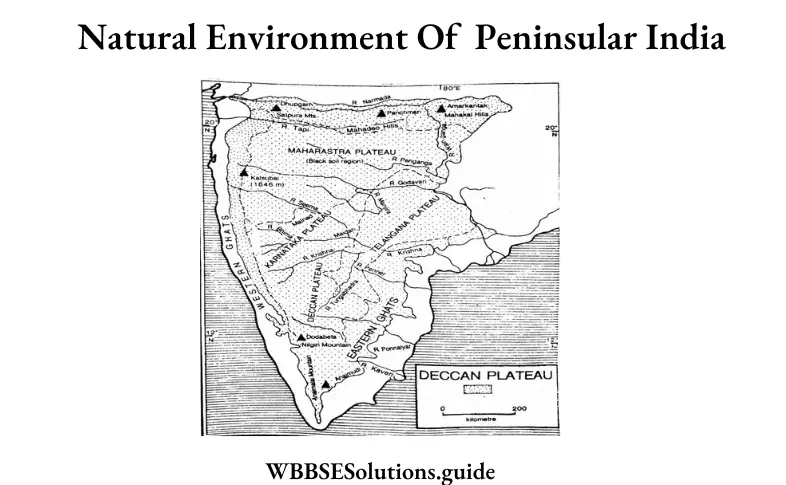
The Eastern Ghat represents a series of broken and detached hill ranges. These hills stretch from Orissa to the Nilgiri hills of Tamil Nadu. In fact, they comprise a series of relief mountains like the Nallalai, the Banksamo, Mahendragiri, Shevaroy, and Nilgiri hills. These hills are mostly composed of Archean and Guddapah rocks. The Western Ghats extend for about 1000 miles along the western coast of India from the Tapti to Cape Comorin. The Western Ghats, also known as Sahyadris, present a step-like character formed as a result of weathering of the horizontal layers of Deccan Basalts. The northern parts of these mountains up to the Tapti river is formed of the Deccan Traps, while the southern part consists of Archean guises, shirts, etc.

The Western Ghats form a watershed of the Peninsula and most of the rivers originate from the Bay of Bengal to the east.
Due to the paucity of rainfall, and rugged relief, cultivation is practiced with much difficulty. In the fertile ‘black cotton soil’ region, however, cotton, jowar, and groundnut are cultivated with success. This is also rich in iron, manganese, mica, and other mineral resources. Consequently, upon the development of water power, industrial development has also been possible here on the plateau.

Question 15. What are the significances of the peninsular plateau region on the people of India?
Answer:

The significances of the peninsular plateau region on the people of India

Significance of Peninsular Plateau Region: The Peninsular Plateau of India is the oldest landmass of the Indian subcontinent and is said to be a part of the ancient Gondwanaland. The region has been immensely contributing to the prosperity of the country due to its richness in minerals, fauna, forests, etc.
1. Peninsular India is a depository of minerals. Jharkhand, Orissa, Madhya Pradesh, Chhattisgarh, and south-east Rajasthan—all lying in Peninsular India—are associated with a variety of minerals, such as iron, bauxite, mica, manganese, copper, chromium, and coal. Karnataka and Andhra Pradesh have considerable reserves of iron, gold, chromium, and porcelain clay. The Telangana region has coal, mica, graphite, and corundum.
2. The north-western plateau of Peninsular India is covered with basaltic lava which is rich in iron. Soil formed of basaltic lava, i.e., black soil is conducive for the cultivation of cotton. This soil also facilitates the production of tea, rubber, coffee, and millet. Tobacco, groundnuts, and oilseeds are abundantly grown in the peninsular region.
3. The highlands of the plateau are covered with different types of forests. Deciduous and evergreen forests are the characteristics of Peninsular India. Ebony, mahogany, cane, bamboo, eucalyptus, sal, sisum, and sandalwood are prominent commercial timbers of the region, while tall grasses, shrubs, and herbs provide fodder.
4. The Peninsular rivers are marked by a number of waterfalls that are being harnessed for the production of hydroelectricity. These peninsular rivers have also been impounded for irrigation and hydroelectric power.
5. The Western Ghats are among the finest faunal tracts of India. These include the Nilgiri Ibex, the black monkeys, and the lion-tailed macaque in the southern reaches (Kerala and Tamil Nadu) of the Western Ghats. Forests in the peninsular region are also home to wild elephants, sambhar, cheetahs, leopards, and tigers.

Question 16. Write in brief what you know about the coastal plains of India.
Answer:

Coastal plains of India

The Deccan Plateau has a coastal strip in the east and in the west which are known as coastal plains. They run along the coastline of the peninsula from the Rann of Kutchchh in the west to the Ganga Brahmaputra delta in the east. The Western Coastal plains lie on the coastal strip along the Arabian Sea and west of the western Ghats while the Eastern Coastal plains lie between the Bay of Bengal and the Eastern Ghats. The two plains meet at the tip of the peninsula, i.e., at Cape Comorin.
Western Coastal Plains:


WBBSE Solutions For Class 10 Geography And Environment India - Physiography Of India coastal plains of India.

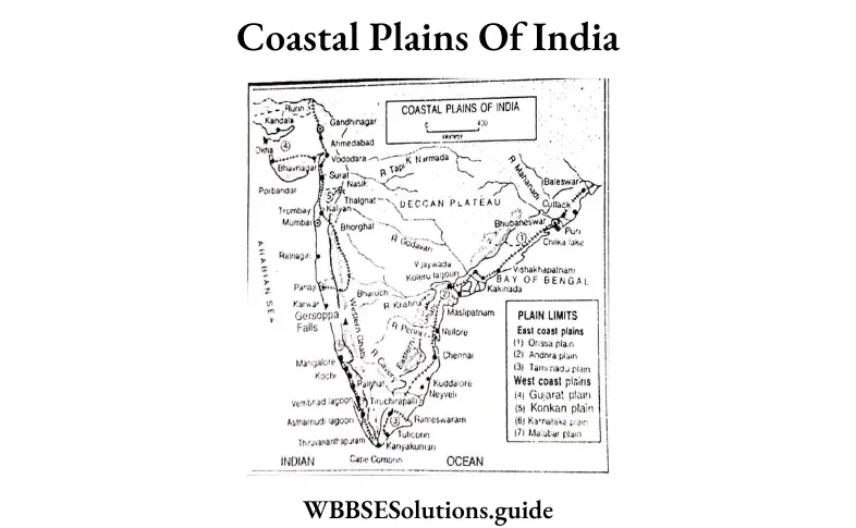
1. Gujarat Plains: They are located in the southern side of the Thar Desert.
2. The Kutchchh Peninsula: The westernmost section of the Western Coastal Plains is called the Rann of Kutchchh which covers an area of 21,500 sq. km in northern Gujarat. This area is open to marine inundation and is composed of dark silt. Due to the deposition of silt, salt marshes are formed during the dry season.
3. The Kathiawar Peninsula: This peninsula is located in the south of the Kutchchh peninsula. It is a sandy plain with some hills like Mt. Girnar. Its southern part has mostly alluvium brought down by the rivers from the Western Ghats.
4. The Konkan Coast: The coastal plains from Daman to Goa are called the Konkan Coast. This 500 km stretch is generally flat and is composed of basaltic trap-rocks.
5. The Kanara Coast: It runs from Goa to Cannanore for 525 km. In this stretch, significant estuaries are formed near Goa.
6. The Malabar Coast: It is the southernmost stretch of the western coastal plain which runs from Cannanore to Cape Comorin for 500 km. It is known as the Malabar coast. Its characteristic features are the lagoons or backwaters called kayaks, such as the Ashtamudi and Vembanad lakes.

Eastern Coastal Plains: The coastal areas along the Bay of Bengal are broad and more leveled. The area is rocky, except for the delta region, and is highly dissected by small but fast-flowing rivers. Several depositional features such as spits, lagoons, and offshore bars are found along the coast. The prominent deltas are those of the Mahanadi, Godavari, Krishna, and Cauveri. These deltas are not suitable for harbors as their mouths are full of silt. There are several lakes on the East Coast; these include the Chilika in Orissa and Kolleru and Pulicat in Andhra Pradesh. From the mouth of the Ganga to Nellore the plains are called Northern Circars. These plains lie between the Mahanadi and the Krishna rivers. The southern part of the Eastern Coastal Plains from Nellore to Kanyakumari is called Coromandel Coast in Andhra Pradesh and Tamil Nadu.

Question 17. Give an account of the physiography of the islands of India.
Answer:

Physiography of the islands of India

Besides the mainland, India has two groups of islands, i.e., the Andaman and Nicobar islands in the Bay of Bengal and the Lakshadweep islands in the Arabian Sea.
Andaman and Nicobar islands: The Andaman and Nicobar Islands are a group of more than 300 islands, out of which 265 are uninhabited. The two groups of islands are separated by the Ten-degree channel. The Andaman Islands lie in the Bay of Bengal 1,255 km from Kolkata and 1,190 km from Chennai. The islands are 193 km from Cape Negrais in Myanmar. Five large islands grouped together are called the Great Andamans and to the south is the island of Little Andaman.

There are 204 islets. The Great Andaman group is about 467 km long and, at the widest, 51 km wide. Andaman and Nicobar Islands are formed by the elevated parts of submarine ridges that are extended southward from the Arakan Yoma Mountains of Myanmar. These islands are highly dissected and rise to 730 m in height. There are 550 islands, most of which are too small to be inhabited.

The Nicobar Islands are situated to the south of the Andamans, 121 km from Little Andaman. There are 19 islands, 7 uninhabited, with a total area of 1.841 sq km. The islands are usually divided into three sub-groups: southern, central, and northern. The chief islands are Great Nicobar and Car Nicobar. These islands are of volcanic origin. The only active volcano of India is found on Barren Island. Narcondam is another volcanic island in this group. They are surrounded by coral reefs and have narrow coastal plains.

The Lakshadweep Islands: Lakshadweep consists of a group of 36 islands, of which only 11 are inhabited and located about 280 to 480 km from the Kerala coast. It was constituted as a Union Territory in 1956 as the Laccadive, Minicoy, and Amindivi Islands, and renamed in November 1973 as Lakshadweep. The northern portion is called the Amindivis. The remaining islands are called the Laccadives (including Minicoy Islands).

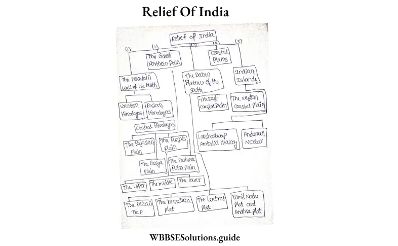
Question 18. Give a chart to show the divisions of India according to relief and structure.
Answer:

According to the relief and structure of India, it can be divided into 5 main physical divisions. These are:

WBBSE Solutions For Class 10 Geography And Environment India - Physiography Of India Relief Of India

Question 19. Divide and explain the Ganga Plain.
Answer:

The Ganga plains can be divided into the following:

1. The Upper Ganga Plain: Occupying the western part of the UP, the Upper Ganga plain is agriculturally the most developed of the three segments of the Ganga plains. This region is a plain alluvial tract that has the Shiwaliks in the north, the Peninsular Plateau in the south, and the Yamuna in the west. It is drained by the rivers Ganga, Yamuna, Ghagra, Gomti, and Sharda. About three-fourths of the total area is under cultivation, two-thirds of which has irrigation by canals and tubewells/wells.

2. The Middle Ganga Plain: It comprises the eastern part of UP and the northern part of Bihar. The middle Ganga plain is a flat gently sloping area. It measures 600 km from east to west and about 330 km from north to south. It is surrounded by the Shiwaliks in the north and the Deccan plateau in the south. It is drained by the Ganga and its numerous tributaries, among which Ghaghra, Gandak, and Kosi are the major ones. The Mahananda river defines its eastern boundary. This area is also dotted with oxbow lakes, levees, marshes, etc. Rainfall is high in this region. It causes frequent floods in this area. Moreover, the rivers keep on shifting their course. The river Kosi called the ‘sorrow of Bihar’ has shifted its course over 120 km in recent times. About two-thirds of this area is under cultivation. Nearly one-third of it is irrigated by canals and tube wells. Rice ranks as the leading crop which accounts for 40 percent of the cropped area. The other major food crops are wheat, barley, maize, and pulses. Sugarcane is the major cash crop.

3. The Lower Ganga Plain: This region coincides with the lower course of the river. It is a flat river plain. It is drained by the Ganga which is known as Padma, and other streams, such as the Damodar, Rupnarayan, and Subarnarekha. These streams originate from the adjacent Chotanagpur plateau. The Ganga along with the Brahmaputra forms the world’s largest delta. A large part of this delta is covered by thick forests called the SundarbAnswer: Estuaries, mangroves, swamps, sandbanks, etc. mark the sea-face of the delta. Agriculture is the livelihood of a majority of the population in this region. Nearly two-thirds of the total area is under cultivation, and two-thirds of the area under cultivation is under rice cultivation. Jute is a prominent commercial crop.

WBBSE Model Question Paper 2023 History And Environment Set 1

Group A Choose The Correct Option:

Question 1. The Game of football was introduced in India by

  1. English
  2. Dutch
  3. French
  4. Portuguese

Answer: 1. English

Question 2. Bipin Chandra Pal wrote

  1. Sattar Baths
  2. Jeebon Smriti
  3. A Nation in Making
  4. Ananda Math

Answer: 1. Sattar Baths

Question 3. The Editor of Bamabodhini Patrika was

  1. Umesh Chandra Dutta
  2. Sisir Kumar Ghosh
  3. Krishnachandra Mazumdar
  4. Dwarkanath Vidyabhushan

Answer: 1. Umesh Chandra Dutta

Read and Learn also WBBSE Madhyamik Model Question Paper 2023 Geography And Environment

Question 4. The General Committee of Public Instruction was formed in

  1. 1713 A.D.
  2. 1913 A.D.
  3. 1813 A.D.
  4. 1823 A.D.

Answer: 4. 1823 A.D.

WBBSE Madhyamik History and Environment Model Question Paper 2023 Set 1 PDF Download

Question 5. ‘Naba Bidhan’ was established by

  1. Dayanand Saraswati
  2. Keshab Chandra Sen
  3. Swami Vivekananda
  4. Maharshi Debendranath Tagore

Answer: 2. Keshab Chandra Sen

WBBSE Model Question Paper 2023 History And Environment Set 1

Question 6. Sui Munda was the leader of

  1. Chuar Rebellion
  2. Kol Rebellion
  3. Santhal Hool
  4. Munda Rebellion

Answer: 2. Kol Rebellion

Question 7. By the Forest Law of 1878 A.D., forests were divided into

  1. Two categories
  2. Three categories
  3. Four categories
  4. Five categories

Answer: 2. Three categories

Question 8. The Great Revolt of 1857 was described as India’s First War of Independence by

  1. Subhas Chandra Bose
  2. Jawaharlal Nehru
  3. V. D. Savarkar
  4. Rashbehari Bose

Answer: 3. V. D. Savarkar

Question 9. The first political association in India was

  1. Indian Association
  2. Indian National Congress
  3. Bangabhasha Prakashika Sabha
  4. Landholder’s Society

Answer: 3. Bangabhasha Prakashika Sabha

Question 10. ‘Bharat Mata’ was painted by

  1. Abanindranath Tagore
  2. Rabindranath Tagore
  3. Nandalal Bose
  4. Gaganendranath Tagore

Answer: 1. Abanindranath Tagore

Question 11. The process of Half-tone printing was introduced in India by

  1. Upendrakishore Roychowdhury
  2. Sukumar Roy
  3. Panchanan Karmarkar
  4. Charles Wilkins

Answer: 1. Upendrakishore Roychowdhury

Question 12. Vishva-Bharati was founded by

  1. Ishwarchandra Vidyasagar
  2. Rabindranath Tagore
  3. Swami Vivekananda
  4. Dedarnath Tagore

Answer: 2. Rabindranath Tagore

Question 13. The leader of the ‘Eka’ movement was

  1. Madari Pasi
  2. Dr Ambedkar
  3. Mahatma Gandhi
  4. Baba Ramchandra

Answer: 1. Madari Pasi

“madhyamik question paper 2022 “

Question 14. All India Trade Union Congress was founded in

  1. 1917 A.D.
  2. 1920 A.D.
  3. 1927 A.D.
  4. 1929 A.D.

Answer: 2. 1920 A.D.

Class 10 Maths Class 10 Social Science
Class 10 English Class 10 Maths
Class 10 Geography Class 10 Geography MCQs
Class 10 History Class 10 History MCQs
Class 10 Life Science Class 10 Science VSAQS
Class 10 Physical Science Class 10 Science SAQs

Question 15. The Bardo Satyagraha was held in

  1. Bombay
  2. Punjab
  3. Madras
  4. Gujarat

Answer: 4. Gujarat

Question 16. The Anti-Partition movement in Bengal had taken place in

  1. 1904 A.D.
  2. 1905 A.D.
  3. 1906 A.D.
  4. 1911 A.D.

Answer: 2. 1905 A.D.

Question 17. Matangini Hazra was associated with the Quit India Movement in

  1. Tamluk
  2. Sutahta
  3. Barisha!
  4. Purulia

Answer: 1. Tamluk

Question 18. Dipali Sangha was founded by

  1. Kalpana Datta
  2. Lila Nag (Roy)
  3. Basanti Devi
  4. Bina Das

Answer: 2. Lila Nag (Roy)

Question 19. ‘Iron Man of India’ refers to

  1. Mahatma Gandhi
  2. Sadar Vallabhbhai Patel
  3. Muhammad Ali Jinnah
  4. Rajendra Prasad

Answer: 2. Sadar Vallabhbhai Patel

Question 20. ‘A Train to Pakistan’ was written by

  1. Jawaharlal Nehru
  2. V. P. Menon
  3. Khushwant Singh
  4. Salman Rushdie

Answer: 3. Khushwant Singh

Group-‘B’ Answer In One Sentence:

Question 1. Who was the editor of ‘Somprakash’?
Answer: The editor of ‘Somprakash’ was Dwarkanath Bidyabhusan.

Question 2. Where are government documents preserved?
Answer: The government documents are preserved in Mahafiz Khana.

Question 3. Which century is called the century of Renaissance in Bengal?
Answer: The 19th century is called the century of Renaissance in Bengal.

Question 4. What is meant by ‘Ulgulan’?
Answer: ‘Ulgulan’ means Great Tumult.

State Whether True Or False :

Question 1. The Ramakrishna Mission was set up by Sri Ramakrishna.
Answer: False

Question 2. Lord Dalhousie was the Governor-General of India during the Great Revolt.
Answer: False

Question 3. Rabindranath Tagore supported the cause of the European community through the novel ‘Gora’.
Answer: False

Question 4. Gandhiji and Dr Ambedkar jointly fought for the rights of the Dalits.
Answer: False

“madhyamik exam 2023 Bengali question paper “

Match Column ‘A’ With ‘B’:

Column ‘A’                                                   Column ‘B’
Aurobindo Ghosh                                         1. Indian National Army
Taraknath Palit                                              2. Bengal National School and College
Nabagopal Mitra                                          3. Bengal Technical Institute
Rashid Ali                                                      4. Hindu Mela

Answer:
Aurobindo Ghosh: 2. Bengal National School and College
Taraknath Palit: 3. Bengal Technical Institute
Nabagopal Mitra: 4. Hindu Mela
Rashid Ali: 1. Indian National Army

Match The Statements Below With Their Appropriate Explanation:

Statement 1: The ‘Eka’ Movement was organised in Uttar Pradesh.
Explanation 1. This was an individual movement.
Explanation 2. This was a peasant movement.
Explanation 3. This was a workers’ movement.
Explanation 4. This was a peasant movement.

Answer: Explanation 2. This was a peasant movement.

Statement 2: The Government of India framed the Meerut Conspiracy Case in 1929.
Explanation 1. To suppress the revolutionaries.
Explanation 2. To suppress the Civil Disobedience Movement.
Explanation 3. To suppress country-wide communist activities.
Explanation 4. To suppress country-wide communist activities.

Answer:
Explanation 3. To suppress country-wide communist activities.

Statement 3: The leftists played an important role in the anti-colonial movements of 20th Century India.
Explanation 1. The leftists were the supporters of zamindars and industrialists.
Explanation 2. They were supporters of British imperialism.
Explanation 3. They were the supporters of the united struggle of peasants and workers against British rule.
Explanation 4. They were the supporters of the united struggle of peasants and workers against British rule.

Answer:
Explanation 3. They were the supporters of the united struggle of peasants and workers against British rule.

Statement 4: Indian Women participated in the national movement for the first time during the anti-partition movement.
Explanation 1. Because they were inspired by Gandhiji.
Explanation 2. Because they were inspired by the revolutionary theories of Aurobindo Ghose.
Explanation 3. Because they wanted to boycott foreign goods.

Answer:
Explanation 3. Because they wanted to boycott foreign goods.

Group – ‘C’

Answer The Following Questions In Two Or Three Sentences (Any Eleven):

Question 1. What is Social History?
Answer:

Social History: Social history is a branch of history that studies the experiences of the daily life of people and their social and economic relationships. It also includes religious and cultural affairs such as literature, education, music, etc.

Question 2. What is the importance of newspapers as a source of History?
Answer:

The importance of newspapers as a source of history is as follows:

1. We get an idea about the political history of a nation from the contemporary political news published in newspapers.
2. We also come to know about the contemporary culture and society of a state or a country from related news published in newspapers.

Question 3. Analyse the role of Raja Radhakanta Deb in promoting women’s education in Bengal.
Answer:

The role of Raja Radhakanta Deb in promoting women’s education in Bengal

Raja Radhakanta Deb, the zamindar of Sobhabazar, played a pivotal role in. promoting women’s education in Bengal during the 19th century. Although he was a follower of orthodox Hinduism, he strongly supported the cause of women’s education and set up many educational institutes for them. Being a member of the Calcutta School Book Society (established in 1817), he helped in setting up several co-ed institutions. Radhakanta Deb also published Pandit Gourmohan Vidyalankar’s ‘Strisikshabidhayak’, which influenced the development of women’s education.

” madhyamik 2023 English question paper solved”

Question 4. Why was there a rift in the Brahmo Samaj of India?
Answer:

Several factors were responsible for the rift in the Brahmo Samaj, among which the most prominent ones involved Keshab Chandra Sen himself, who was the then leader of the Brahmo Samaj. His affinity towards the British, belief in the reincarnation of God, his doubts about the concept of women’s liberation and getting his 14-year-old daughter (who was a minor) married to the Maharaja of Cooch Behar led to dissatisfaction among his followers. Thus, his followers gave up the Bharatvarshiya Brahmo Samaj (led by Keshab Chandra Sen) and founded the Sadharan Brahmo Samaj. The latter was established in 1878 by Shibnath Shastri, Bijoy Krishna Goswami, Anandmohan Basu, Dwarkanath Gangopadhyay, and Durgamohan Das.

Question 5. Was the Farazi movement a movement of religious revival?
Answer:

The Muslims were the major participants in the Farazi movement, which was primarily initiated to restore the Muhameddan power in Bengai (Farazi meaning ‘obey the dictates of Allah’). Thus, this movement started as an Islamic revivalist movement. However, it turned into an anti-imperialist struggle to expel the British and protest against the merciless landlords and indigo planters. Thus, the Farazi movement was not entirely a movement of religious revival.

Question 6. Briefly describe how the planters tortured the indigo cultivators.
Answer:

The planters tortured the indigo cultivators in many ways. For instance:

1. The planters oppressed the cultivators and forced them to grow indigo instead of other crops.
2. If the peasants declined to cultivate indigo, they were subjected to inhuman torture.
3. The planters even evicted the peasants from their villages to augment the plantation areas.

Question 7. Why is the second half of the nineteenth century called the ‘age of associations’?
Answer:

The whole of the nineteenth century has seen the formation and development of many associations. So, Cambridge historian Dr Anil Sil, in his book ‘The Emergence of Indian

Nationalism: Competition and Collaboration in the Late Nineteenth Century”, has called this period “an age of associations”.

Question 8. How did the novel ‘Ananda Math’ inspire the spirit of nationalism?
Answer:

‘Anandamath’, by Bankim Chandra Chattopadhyay, published in 1882, is a fitting example of a literary work that aroused feelings of national consciousness among the Indian people. The message conveyed by this book to the Indians is to sacrifice their lives for the freedom of their motherland from British rule. It states patriotism is the highest possible virtue. The song Bandemataram, which features in this novel, became the national hymn. ‘Anandamath’ was translated into different Indian languages, due to which several people were inspired by its content.

Question 9. What was the role of the Indian Association for the Cultivation of Science in the development of Scientific Education in Bengal?
Answer:

The Indian Association for the Cultivation of Science played an important role in the development of scientific education in Bengal during the 19th century because of the following reasons:

1. Scientific research was regularly conducted in different fields of physics and chemistry.
2. Many renowned scientists and researchers from different countries came here to conduct their experiments and deliver lectures to popularise science.
3. The ‘Indian Journal of Physics’ was started to publish different scientific research works carried out in this institute.

Question 10. What was the objective of founding Vishva Bharati?
Answer:

The objective of founding Vishva Bharati

The ideals of Visva Bharati were: that the entire world’s combined knowledge to be studied there; it would be a home for students all over the world; it would be a congregation of academics from all over the world and the entire world would merge at Visva Bharati.

Question 11. With what objectives was the All India Trade Union Congress founded?
Answer:

The objectives for the establishment of the All India Trade Union Congress were:

1. Including India as a member of the International Labour Organization.
2. Launching a well-organised labour movement besides the anti-imperialist movements against the British
3. Meeting the rightful demands of the labourers.

Question 12. Why was the Workers’ and Peasants’ Party formed?
Answer:

The Workers’ and Peasants’ Party was formed due to the following reasons:
1. Organising workers’ and peasants’ movements against the oppression of the British on the working class.
2. For protecting the interests of the workers, labourers and peasants.
3. For propagating the ideals of communism among people through periodicals and journals.
4. For unifying the leftist groups.

Question 13. Why was Rashid Ali Day observed?
Answer:

Rashid Ali Day: Various student movements started in Calcutta in protest against the judgement given to Abdul Rashid, the captain of the Azad Hind Fauj. Rashid Ali was given 7 years of rigorous imprisonment in the trial which was held in the Red Fort at Delhi. In protest against this, the Muslim Students’ League and the All India Students’ Federation called a student strike on 11 th Feb 1946 for the release of Captain Rashid Ali from prison. This day was later celebrated as Rashid Ali Day.

Question 14. Who is known as Dalits?
Answer:

Dalits:

From 1930, non-Brahmins, low caste Hindus and the untouchables came to be known as ‘Dalits’. Gandhiji termed them as HarijAnswer: They represented the most exploited and poorest section of society.

Question 15. What Is meant by the Instrument of Accession?
Answer:

Instrument of Accession:

After the independence of India, the incorporation of princely states posed a big problem. At the time of the transfer of power, the British government left these princely states free to join either India or Pakistan. Sardar Vallabhbhai Patel, the first Home Minister of free India, took the responsibility of integrating these princely states with India. The Instrument of Accession, which was consequently drafted, was a legal document to enable each of the rulers of the princely states under British paramountcy to join one of the new dominions of India or Pakistan, created by the Partition of British India. The princely states were to be given freedom in their internal affairs and the Union Government was to have control over the defence and foreign policy of these states.

Question 16. Why was the Nehru-Liaqat Pact (1905) signed?
Answer:

The Nehru-Liaqat Pact (1950) was signed mainly to guarantee the rights of the minorities of India and Pakistan. The pact ensured peaceful cooperation between the two countries, safe transport of the refugees to their respective motherlands and proper return of their ancestral property, safe return of abducted refugee women as well as other related issues.

Group – ‘D’ Answer Any Six Questions In Seven Or Eight Sentences, Taking At Least One From Each Segment:

Question 1. Write a brief note on Women’s History.
Answer:

Women’s History: The subject matter of History involves the whole of mankind, about half of which is comprised by women. However, it can be noted that even in the previous century, women were not given as much importance as men in the pages of history. The study of the role of women in history over time, which is known as women’s history, has begun only recently.

1. Role of women in history: Women have contributed much to the history of every era. Nefertiti, Cleopatra, Razia, Nurjahan, Durgabati and several other female figures have been known to have gained immense political power in the Ancient and Middle Ages. Since then, date, there have been several instances where women have occupied leading social, economic and political positions in different countries all over the world.

2. Neglect of women in history: Though the revolts, battles, and political and diplomatic activities of men have been recorded in history, the same has not been done in the case of women. Female leaders, struggles by women for their rights, their demands, their movements, their progress in art and culture—all these have not been given enough importance in history.

3. Inception of women’s history: In recent times, researchers have started giving importance to the role of women in shaping history. It was only in the 1970s that women’s history began to come into the limelight. As a result, women’s history is gradually gaining prominence at present.

4. Women’s history in the West: In the past few years, women’s history has gained importance in the West as well. Thus, several books dealing with this topic have been written by scholars like Joan Kelly, Gerda Lerner, Betty Friday and Judith Butler.

Question 2. Explain Swami Vivekananda’s ideals of religious reform.
Answer:

Swami Vivekananda’s ideals of religious reform:

Swami Vivekananda (1863-1902 A.D.) was a representative of spiritualism, patriotism and nationalism in India in the 19th century. The ideal of religion that he propagated came to be known as ‘Neo-Vedanta’. Let us now look into his ideas of religious reform.

1. Aim: Vivekananda experienced poverty and grief in his personal life. He also witnessed the poor living conditions of the people of India. These, combined with the teachings of Sri Ramakrishna, influenced him to think deeply about the concept of religion in India. He wanted to free people from the clutches of meaningless rituals that were closely related to religion in his times. His aim was to instil in people the idea that selfless service to man was the actual service to God.

2. New interpretation of religion: The propounder of the ancient philosophy of Advaita Vedanta in India was Sri Adi Shankaracharya (788- 820 A.D.). Swami Vivekananda gave a new interpretation to the Advaita philosophy, which came to be known as ‘Neo-Vedanta”. He explained that Lord Brahma was present everywhere and to serve other human beings was to serve Him.

3. Chicago Summit: Swami Vivekananda attended the Parliament of Religions at Chicago, USA in 1893 (September 11 – 27). There he talked about the ideals of universal tolerance, love and brotherhood as mentioned in Advaita Vedanta.

4. Samadhi or trance: Samadhi, a state of trance, was not given much importance in the Advaita philosophy. But, in his concept of New Vedanta, Swami Vivekananda emphasised ‘samadhi’ as a process for human beings to attain salvation.

Question 3. Why did the Santhals rebel in 1855?
Answer:

A Santhal boy Sidhu was one of the remarkable leaders of the Santhal Rebellion.

Causes :

(1) It was the rent question that created discontent among the Santhals. The rate of tax went on increasing continuously and the Santhal peasants found it difficult to pay the tax.
(2)Besides regular tax, certain illegal taxes were imposed by the Naibs or tax collectors which were collected from the Santhal peasants oppressively.
(3)The Santhals were also subjected to oppression by the moneylenders who charged high rates of interest ranging from 50% to 500%.
(4)The contractors, who were mostly Europeans, were no less oppressive. Examples are not rare to show how the tribal people were subjected to oppression like taking of kids, fowls, etc. without making any payment.
(5)The Santhals themselves took up arms against the oppressors only after they had become convinced that complaints made in the court or to higher officials would be of no avail.
Thus, the first mass gathering took place at Baghnadihi where Santhals were supported by non-Santhal peasants. Later on, the Santhal revolt (hul) took place under the leadership of Siddhu Santhal and Kanu Santhal.

Question 4. What was the attitude of the educated Bengali society towards the great Revolt (1857)?
Answer:

The attitude of the Educated Bengali Society Towards the Revolt of 1857: The Bengali intelligentsia was apathetic to the Revolt of 1857. This is such a ticklish problem that none has been able to offer any satisfactory explanation.

Promotion of Self-Interest: One thing that may be relevant to note is that the Bengali intellectuals, in the mid-eighteenth century, were very much conscious of their own interest. As such it will not be fair to say that they merely echoed the sentiments of the British rulers in taking a negative attitude towards the rebels of 1857. In any case, their hostile attitude towards the Revolt of 1857 cannot be overlooked.

Issue of Enfield Rifle: In Bengal, Barrackpore, near Calcutta was the centre of the initial spark of the Revolt of 1857. The revolt broke out over the religious question that there was a conspiracy to destroy the religions of the sepoys (over the Enfield Rifle issue). This was in tune with the cry of the orthodox Hindus of the city of Calcutta who had long suspected that the British wanted to destroy their religion and caste and convert them to Christianity. The intellectuals of Bengal, who were against orthodoxy and fanaticism, considered the rebel sepoys as the allies of social reaction. Under the circumstances, the Bengali intelligentsia had no option but to oppose the rebellion.

Socio-Economic Reasons: There were also socio-economic reasons for which the Bengali intelligentsia opposed the Revolt of 1857. The intellectuals belonged to middle-class well-to-do families that had been the product of the colonial structure. Their economic status was raised because of trade and commerce, and their intellectual status was due to their English education. In the success of the Revolt of 1857, the return of the old social order with all the reactionary principles and ideals was recognised by the Bengali intelligentsia. Hence, the Bengali intelligentsia did not sympathize with the rebels of 1857.

Conclusion: It has been pointed out by Sri Benoy Ghose that the growing political consciousness of the English-educated Bengali middle class also shaped their hostility towards the Revolt of 1857. The educated Bengali middle class saw no hope in the Revolt of 1857. Thus they condemned the rebels of 1857.

Question 5. Explain the relation between printed books and the spread of education.
Answer:

The relation between printed books and the spread of education

During the 18th-19th century the Indian common folk were largely illiterate and would have remained so for many centuries. But some educated enlightened Indians and a small number of professional people who lived and worked in towns, however, felt the need of books. In India in the past, like many Western countries, copyists multiplied books by hand. But with the introduction of printing, textbooks of all sorts, English and vernacular, grammar, and elementary books were published that catered to the needs of the people. In fact, printed books became a medium for the dissemination of knowledge. The elementary Bengali textbook that deserves mention for the learning of the Bengali language is Varna Parichay by Iswarchandra Vidyasagar. However, how printing helped the dissemination of knowledge may be explained with some examples.

Baptist Mission Press: In 1800 the Baptist Mission was founded in Serampore, and the Baptist Mission Press started printing books in Bengali and other vernacular languages. In the same year, Fort William College was founded by Lord Wellesley in Calcutta. In the college young civilians were taught various languages like Bengali, Parsee, and Hindusthani. Qualified persons were appointed as teachers who needed textbooks for instruction to the students. It was the Serampore Press that supplied books to the students (trainee civilians) of Fort William College.

Vernacular Literature: The Baptist Mission and its Press printed and published textbooks, religious books and other works in vernacular languages, and in English. Also, several books translated from English to Bengali were there in the list of publications. All this facilitated the assimilation of Eastern and Western cultures in this country.

Bengali Press: How the publication of Bengali periodicals and newspapers helped in the dissemination of knowledge may be understood from the comment made in the Oriental Star (16 May 1818) on the occasion of the appearance of the Bengali periodical Bengal Gazette. It was said that the diffusion of general knowledge and information amongst the natives must lead to beneficial effects.

Spread of Education: The printing press helped the spread of education. The middle-class people of the towns who were being educated needed the help of study materials. Printing presses fulfilled their demand. Previously, the copyist, after hard toil could at best produce two books in a year. When there was no printing press the scribes copied manuscripts by hand. The copies made by hand were sometimes illegible, and the reader was forced to guess what was written. But with the invention of printing constant proofreading and correction helped to produce the exact copy of the manuscripts. This made it possible to obtain a fuller knowledge.

Question 6. What was the role of Bengal Technical Institute in the development of technical education in Bengal?
Answer:

Bengal Technical Institute was established by Tarak Nath Palit in Calcutta in 1905 when the Swadeshi Movement started against the partition of Bengal. Its contributions towards the spread of technical education are as follows:

1. Initiative for national education: During the Swadeshi movement, an attempt was made to establish a national system of education as an alternative for the education system of the British Government. One of the objectives of national education was the spread of indigenous technical education. So, Tarak Nath Palit, an Indian lawyer, founded the Bengal Technical Institute in Calcutta on July 25, 1906.

2. Association with other institutes: In order to spread the indigenous system of education, Bengal Technical Institute merged with Bengal National College in 1910 and formed the Bengal National College and Technical School. This joint institution was renamed the College of Engineering and Technology (CET) in 1918.

3. Activities: After the merger of the institutions, arrangements were made for the cultivation of various subjects like Physics, Chemical Technology, Industrial Technology, etc. besides the disciplines of Humanities. As a result, several educated Bengalee youths could receive technical education and become self-dependent. . The students of the College of Engineering and Technology published a journal named ‘Tech’. They dedicated the first edition of this journal to those who had dreamt of national education during the age of the Swadeshi Movement.

Question 7. Write a note on the debate between Gandhi and Ambedkar on Dalit rights.
Answer:

The debate between Gandhi and Ambedkar regarding Dalit rights: There is little doubt that both Gandhi and Ambedkar were very much aware of the problem of the untouchability of the Dalits. Yet there were sharp differences between the two regarding the Dalit issue.

1. Difference: There was little in common in the perception between the two that came to the forefront in the early 30s of the nineteenth century.
2. Difference in opinion: Gandhiji refused to view the Dalits as a minority who should be given political safeguards. Rather he considered it essentially a social problem, and that was to be tackled by the Hindu community itself. Contrarily, Ambedkar, describing the Dalits as ‘slaves’, advocated for communal representation of the Dalits on the ground that ‘untouchability constitutes a definite set of interests which the untouchables alone can speak for.’
3. Real break: Throughout the 1920s, Ambedkar had a soft spot for Gandhi as he took him as one different from the elitist Brahmanic leaders he (Ambedkar) hated. The real break between the two surfaced during the events of the Round Table Conference of 1932.
4. Separate electorate: In the two Round Table Conferences Ambedkar ended up supporting a separate electorate for the untouchables (Dalits).
5. Poona Pact: But this proved to be too much for Gandhiji. For him, the untouchables were a part of Hinduism and a separate electorate for them would create a division in Hinduism. Subsequent Communal Award and Gandhi’s fast unto death led to the Poona Pact of 1932. It must, however, be remembered that Ambedkar’s agreement in signing the Poona Pact was by no means due to his ‘change of heart’. It was Gandhi’s ‘pressure tactics’ that compelled Ambedkar to soften his stand and accept the compromise formula of the Poona Pact. Later on, Ambedkar expressed his unhappiness over the issue and this in the long run increased his bitterness towards Gandhiji.

Question 8. How was India reorganised on the basis of language after independence?
Answer:

Organisation of States on a Linguistic Basis:

Introduction: The linguistic policies of the Nehru Government (1947-64) raised a lot of controversies. After the transfer of power, there was a demand for demarcating the state boundaries on the basis of the language spoken by the people of that area. Nehru was not agreeable to this demand.

Selection of Hindi as National Language: The Constituent Assembly decided to declare Hindi as the National language, winning the voting by one vote only. Nehru implemented the decision, but controversy kept haunting him. Big industrialists belonging to Hindu, Parsi and Jain communities felt that by declaring Hindi as the National language, the Government was aiming at developing a centralised power structure in India. The Constituent Assembly formed the ‘Linguistic Provincial Committee’ in 1948 under justice S. K. Dhar. It was known as the ‘Dhar Committee’.

In 1948, the J. V. P Committee, comprising Jawaharlal Nehru, Vallabh Bhai Patel and Pattabhi Sitaramaiah was set up. It was the duty of the committee to re-organise the Indian states on a linguistic basis and without any controversy. On 1st April 1949, the committee submitted its report saying that ‘No state will be formed right now on the basis of language’. In the report of the Linguistic Provinces Commission, it was informed that ‘The narrow demand for linguistic provinces should be subdued till India becomes a Nation’.

Agitation of South Indians: The Telugu-speaking Gandhian leader Patti Sriramalu, without paying any heed to these recommendations, started fasting with a demand to form a separate state of Andhra Pradesh with the 11 Telugu-speaking districts of Madras. Nehru was not much perturbed, instead, he was quite displeased. When Sriramalu died while fasting, on 15th December 1952, his followers started rioting in the Telugu-speaking districts. So, the Centre was compelled to form a separate state of Andhra Pradesh on 18th December 1952.

Union of Smaller States: During the linguistic reorganisation of states, Sardar Vallabh Bhai Patel joined the smaller native states with their neighbouring states. PEPSU was formed with Patiala and East Punjab States. In the same way, the union of Saurashtra, Rajasthan and Central Province was done. However, since Manipur, Tripura and Nepal were not joined with any state, they continued to be the responsibility of the Central Government. Though some problems were solved through the reorganisation of states, all the issues with the multilingual character of the country could not be solved.

Operation Vijay: The government of India started ‘Operation Vijay’ on 17-18 December 1961, to free Goa, under the command of Major J. N. Chowdhury, which ended on 19th December. The Indian army freed Goa, Daman and Diu. In 1961 Goa was included within the territory of India and on 12th August 1987, it became the 25th State of India.

Group-‘E’

Answer Any One Question In Fifteen Or Sixteen Sentences:

Question 1. What was the Anglicist-Orientalist Controversy in the field of education? Discuss the role of Calcutta University in the spread of higher education.
Answer:

Anglicist-Orientalist Controversy: The difference in opinion that arose between the Anglicists and the Orientalists regarding the type of education to be introduced in India is known as the Anglicist-Orientalist controversy. The Anglicists, consisting of Lord Macaulay – the Law Member of the Governor General’s Legislative Council, Alexander Duff and Rammohan Roy, advocated the cause of English education. Lord Macaulay remarked that the knowledge derived from the books of English literature packed in a single shelf was more valuable than the knowledge that the whole range of Oriental literature would give. The other faction, known as the Orientalists, which includes Princep, Colebrook, etc. advocated the cause of oriental languages like Persian and Sanskrit instead of English. They pointed out that students would be good job hunters but they would fail to deliver to their countrymen if they studied only English.

Role of Calcutta University in the spread of higher education: The British wanted to promote higher education prevalent in India, modelled on the system of education in the West. With this view, the University of Calcutta was established at the time of Lord Canning in 1857 (January 24). The role of this university in spreading higher education in India is immense.
1. Western Systems of Education: The University of Calcutta is the oldest of the modern universities in India. It was also the first Western-style university in the whole of Asia. Initially, higher education in the region extending from Lahore to Rangoon as well as Sri Lanka was supervised by this university.
2. Excellence in education: The level of education in this university reached its peak of excellence during the Vice-Chancellorship of Sir Asutosh Mukhopadhyay (1906-14 and 1921 -23). It was during his time that research works in the fields of arts and science gained worldwide recognition. Many scholars from around the world came and taught here on his request. Rabindranath Tagore himself was a chief examiner in this university.
3. First graduates: Jadunath Bose and Bankim Chandra Chatterjee became the first graduates from the University of Calcutta in 1858. The first D.Litt. in Asia, Benimadhab Barua, was also a student of this university.
4. Noteworthy students: Some of the noteworthy students of this university were Jagadish Chandra Bose, Prafulla Chandra Ray, Satyendra Nath Bose, Meghnad Saha, C.V.Raman, Sarvapalli Radhakrishnan, R.C.Majumder, Suniti Kumar Chatterjee, Niharanjan Roy and Subhas Chandra Bose. All of them are known for their exceptional contribution in different fields.

Question 2. Briefly discuss the nature of the Great Revolt of 1857.
Answer:

Nature of the Great Revolt of 1857: Historians differ regarding the nature of the Great Revolt. Some infer that it is a Sepoy Mutiny while some say it is the First War of Independence. “Whatever might have been its original character, it soon became a symbol of challenge to the mighty British power in India”. (Dr. R.C. Majumdar).

Sepoy Mutiny: The most popular nature of the Great Revolt was Sepoy Mutiny. According to Sir John Silly, Charles Reikes, Charles Robert, John Key, etc. the revolt was nothing more than a Sepoy Mutiny. Even contemporary Indian scholars like Akshay Kumar Dutta, Ishwar Chandra Gupta, Dadabhai Naoroji, Syed Ahmed, H.C. Mukherjee, etc. also are satisfied with this comment of the British scholars. According to Sir John Silly, “The mutiny of 1857 was a wholly unpatriotic and selfish Sepoy Mutiny with no native leadership and no popular support”.

Feudal RevoltDr. R.C. Majumdar and Dr S.N. Sen think (Dr R.C. Majumdar’s view) that the revolt of 1857 was a feudal revolt. The feudal classes like Nana Saheb, Laxmi Bai, etc. joined the revolt to take revenge for the loss of their privileges.
First War of Independence – The nationalists in India, prominent amongst whom is Subhash Chandra Bose and V.D. Savarkar, have hailed it as “the First War of Independence”. But in the view of Dr R.C. Majumdar, “the so-called First National war of Independence was neither First nor National ora war of Independence”.

National Revolt: Disraeli, the leader of the Tory party, declared this rebellion as a ‘National Revolt’ in the British Parliament. Many British historians like J.B. Norton, Alexander Duff, Malleson, James Outram, Holmes and Karl Marx also regard it as a national revolt. According to Karl Marx, “What the British rulers consider a military revolt is basically a National Revolt”. The common people also revolted along with specials in northern and central India. In some places of U.P. and Bihar, the peasants and artisans rebelled against English rule. The rebels even did not hesitate to swarm into treason. The participation of the common people gave the revolt its popular character. We can conclude in the words of Dr R.C. Majumdar, “It (Revolt) remained a shining example before the nascent nationalism in India in its struggle for freedom from the British yoke”.

Question 3. Analyse the role of women in the armed revolutionary struggle.
Answer:

The role of women in the armed revolutionary struggle

Introduction: In the 20th century, a number of women got involved in the armed revolutionary struggle against the British in India. Some of the prominent members of the Deepali Sangha — Pritilata Waddedar, Kalpana Datta, Suhasini Ganguly, Shanti Ghosh, Suniti Chowdhury and Bina Das were actively involved in the armed revolt.

1. Dipali Sangha: Freedom fighter Lila Nag formed the Deepali Sangha in Dhaka in 1923. This was done with the objective of encouraging the women of Bengal to take part in anti-British movements. The members of this association were given physical training and were also taught to wield lathis and other weapons.

2. Chittagong Armoury Raid: Pritilata Waddedar played an important role in the Chittagong Armoury Raid, which was organised under the leadership of Surya Sen in 1930. She fought bravely against the British, along with other freedom fighters, in the bloody battle at Jalalabad Hills and narrowly escaped the British police.

3. Attack on the European Club: In 1932, Pritilata Waddedar, along with some of her associates, Shanti Chakraborty and Kalikinkar Dey, attacked the Pahartali European Club. This resulted in an encounter between the rebels and the police. To avoid being captured by the police, Pritilata Waddedar consumed potassium cyanide and committed suicide.

4. Activities of Kalpana Dutta: Kalpana Datta was a member of the Indian Republican Army, an armed resistance group led by Surya Sen. She was entrusted with the duty of carrying explosives from Calcutta, to help the freedom fighters escape from prison. She also took up the responsibility of attacking the European Club along with Pritilata Waddedar. However, she was arrested before she could carry out her plan of attack.

5. Attack on Stanley Jackson: Bina Das actively participated in the boycott of the Simon Commission in 1929. At her convocation ceremony at the University of Calcutta (1932), Bina fired several shots at the Governor, Sir Stanley Jackson. However, she missed her target and was consequently arrested and sentenced to 9 years of rigorous imprisonment.

6. Jhansi Regiment: The women’s regiment of Subhas Chandra Bose’s Indian National Army
was known as the Rani of the Jhansi Regiment. It was led by Dr Laxmi Sehgal in 1944. Laxmi was captured when the Indian National Army was defeated at the hands of the British and the Jhansi regiment was later disbanded.

Limitations: There are certain noticeable limitations on the participation of women in the anti-British movements in India –

1. Mainly the women of Bengal participated in these movements. Women in the rest of India did not participate much in the movements against the British.

2. It was mostly the educated women from the higher strata of society who took part in these movements. There was not much awareness of the freedom struggle among the women of the lower classes of society.

WBBSE Solutions For Class 10 Geography And Environment India – Location, Administrative Divisions

India Location, Administrative Divisions True Or False Type:

Question 1. Sri Lanka is a neighboring country that shares a boundary with India.
Answer: False

Question 2. The largest union territory is Pondichery.
Answer: False

Question 3. Haryana attained statehood in 1966.
Answer: True

Read and learn all WBBSE Solutions For Class 10 Geography And Environment

Question 4. Goa, Daman, Diu became a part of India in 1961.
Answer: True

Question 5. State Reorganisation Committee was set up in 1953.
Answer: True

Question 6. Himachal Pradesh was made a full-fledged state in 1970.
Answer: True

“WBBSE Solutions for Class 10 Geography India Location and Administrative Divisions”

Question 7. Chandigarh is the capital of Punjab and Haryana.
Answer: True

Question 8. The largest state of India is Madhya Pradesh.
Answer: False

Question 9. The extreme southern point of India is Indira Point.
Answer: True

India Location, Administrative Divisions  Fill In The Blanks Type:

Question 1. The total area of India is ______ sq. km.
Answer: 32,87,263 sq. km.

Question 2. The newest state of India is ______.
Answer: Telangana.

Question 3. India includes 29 states & ______ Union Territories.
Answer: 7.

Question 4. Meghalaya became a state in ______.
Answer: 1972.

Question 5. Manipur attained statehood in ______.
Answer: 1972.

Geography Class 10 West Bengal Board

Question 6. Mysore became Karnataka in ______.
Answer: 1973.

Question 7. State Reorganisation Act was passed in ______.
Answer: 1953.

“Class 10 Geography and Environment India Location solutions WBBSE”

Question 8. Arunachal became a state of India in ______.
Answer: 1987.

Question 9. Haryana became a state of India in ______.
Answer: 1966.

Question 10. The largest state of India is ______.
Answer: Rajasthan.

Question 11. The smallest state of India is ______.
Answer: Goa.

WBBSE Solutions For Class 10 Geography And Environment India - Location, Administrative Divisions

India Location, Administrative Divisions Very Short Answer Type:

Question 1. In which year India became the Sovereign Democratic Republic?
Answer: On 26th January 1950, India became the Sovereign Democratic Republic.

Question 2. How many states are there in India at present?
Answer: There are 29 states at present in India.

Question 3. How many union territories are there in India at present?
Answer: There are seven union territories in India at present.

Question 4. When was Mysore’s name changed to Karnataka and that of Laccadives, Minicoy, and Amindivi to Lakshadweep?
Answer: Both in 1973.

Question 5. What was the position of India in 1956?
Answer: There were 14 states and 6 union territories in India in 1956.

Question 6. When was the State Reorganisation Committee was set up?
Answer: In 1953, State Reorganisation Committee was set up.

“WBBSE Class 10 Geography Administrative Divisions solved questions”

Question 7. How many Union Territories are there in the Indian Union?
Answer: Seven.

Question 8. What was the main basis of state reorganization in India?
Answer: Language and Population.

Class 10 Maths Class 10 Social Science
Class 10 English Class 10 Maths
Class 10 Geography Class 10 Geography MCQs
Class 10 History Class 10 History MCQs
Class 10 Life Science Class 10 Science VSAQS
Class 10 Physical Science Class 10 Science SAQs

Question 9. What is the area of India?
Answer: 32,87,263 sq. km.

Question 10. When did Meghalaya come into being as a state?
Answer: 1972 A.D.

Question 11. In which year Himachal Pradesh became a state?
Answer: 1971 A.D.

Question 12. In which year Andhra Pradesh became a state?
Answer: 1953 A.D.

Question 13. In which year Haryana became a state?
Answer: 1966 A.D.

Question 14. In which year Chhattisgarh came into being as the 26th state of India?
Answer: 1st November 2000 A.D.

Question 15. In which year Uttaranchal came into being as the 27th state of India?
Answer: 1st November 2000 A.D!

Question 16. In which year Chhattisgarh came into being as the 28th state of India?
Answer: On 15th November 2000 A.D.

Question 17. In which year Sikkim became a constituent state of India?
Answer: 26th April 1975 A.D.

Question 18. In which year Mizoram and Arunachal Pradesh became full-fledged states of India?
Answer: On 20th February 1987 A.D.

Question 19. Which is the smallest union territory of India?
Answer: Lakshadweep.

Question 20. Which is the most densely populated state in India?
Answer: West Bengal.

Question 21. Name the most densely populated union territory of India.
Answer: Delhi.

“WBBSE Geography and Environment India Location solutions PDF”

Question 22. In which year the State Reorganisation Act was passed?
Answer: in 1956.

Question 23. In which year Nagaland became a state?
Answer: In 1962.

Question 24. In which year Punjab was reorganized?
Answer: In 1966. It was made into two states: Punjab and Haryana.

Question 25. Which is the youngest state of India?
Answer: Telangana.

Question 26. Name a Cape in south India.
Answer: Cape Comorin.

India Location, Administrative Divisions 2 Marks Questions And Answers:

Question 1. When did Meghalaya come into being as a state? Who named it?
Answer:

Meghalaya was carved out of Assam in 1970 as a Union Territory. It became a full-fledged State in 1972. It like many other places such as Marusthali, Arunachal Pradesh, etc. was named by Prof. S.P. Chatterjee, the doyen (the most respected person) of geography in India.

Question 2. Name the largest and the smallest States in India in terms of their area.
Answer:

Rajasthan is the largest state in India and Sikkim is the smallest state in India.

Question 3. When were the following States formed:
(1)Andhra Pradesh, (2) Himachal Pradesh?
Answer:

(1) On 1st October 1953 out of Madras State.
(2) In 1954 Himachal Pradesh emerged as a centrally administered territory and in 1971 as a full-fledged State.

“India Location and Administrative Divisions Class 10 WBBSE solutions”

Question 4. When did Harayana and Chandigarh come into being?
Answer:

On November 1st, 1966, Punjab was divided into Punjab and Haryana as full-fledged States and Chandigarh as a Union Territory.

Question 5. Where is New Delhi situated?
Answer:

New Delhi, the capital of India, is within the Union Territory of Delhi-situated on the bank of the Yamuna River.

Question 6. When did (1) Dadra and Nagar Haveli and (2) Goa, Daman, and Diu become part of India?
Answer:

(1) August 1961, (2) December 1961.

Question 7. In which year did (1) Nagaland, and (2) Arunachal Pradesh come into being?
Answer:
(1) Nagaland became a Union Territory in December 1957 and a full-fledged state in December 1963.
(2) In 1957, North-East Frontier Agency (NEFA) was carved out of Assam as a Union Territory. It was renamed Arunachal Pradesh in 1972.

“Class 10 WBBSE Geography India Location important questions”

Question 8. What was the position of India when she acquired independence in 1947?
Answer: At that time there were 15 states governed by governors, 5 states governed by chief commissioners and there were more than 600 princely states.

Question 9. What was the basis of the reorganization of the united states? In which year State Reorganisation Act was passed?
Answer: Language was the main basis of the state reorganization of India. The Act was passed in the year 1956.

Question 10. What was the main basis of state reorganisation in India and why?
Answer: Language was the main basis of state reorganisation in India because there was a widespread public demand for it.

Question 11. Name and locate the water bodies surrounding India.
Answer: India is surrounded by water bodies on three sides, i.e., the Bay of Bengal in the southeast, the Indian Ocean in the south, and the Arabian Sea in the southwest.

Question 12. Write the latitudinal & longitudinal extent of India.
Answer: India lies between 8°4′ (Cape Comorin) and 37°6′ (the northern extreme of Jammu & Kashmir) north latitudes, and 68°7′ (the western end of Gujarat) and 97°25′ (the eastern end of Arunachal Pradesh) east longitudes.

Question 13. Name two islands that covered India.
Answer: (1) Andaman & Nicobar Islands, (2) Lakshadweep.

India Location, Administrative Divisions 3 Marks Questions And Answers:

Question 1. State how West Bengal attained its present shape since the partition of India in 1947.
Answer:

At the time of the partition of India, West Bengal was a truncated state northern and southern parts remained separated from each other. Cooch Behar became a part of West Bengal in 1948 and the French Chandanagar-Gourhati in 1954. In 1956 when the Purulia subdivision and parts of the Kishengunj subdivision of Bihar were added, the State attained its present shape.

Question 2. Name any three union territories of India along with their capitals.
Answer:

Three union territories of India are :

(1)Lakshadweep: Kavaratti
(2)Damanand Diu: Daman.
(3)Andaman and Nicobar Islands: Port Blair.

“WBBSE Class 10 Geography India Location chapter answers”

Question 3. State three basis of division of states after Independence.
Answer:

Basis of the division of states of India after Independence: After independence, the different states or provinces of India were demarcated on the basis of some criteria; namely, language, culture, administration skills, economic stability, and physical and geographical similarities.

1. Language: India is a land where people speak different languages in different parts of the country. Based on this, the states were demarcated in 1956, designating the region speaking a common language as one state. E.g. the region where most people speak Assamese was marked as Assam, and the region where most people speak Punjabi was marked as Punjab.
2. Administrative advantage arid skill: Although language was a criterion of demarcating states, only this could not work very well. E.g. Hindi is the main language spoken in Uttar Pradesh, Bihar, Jharkhand, Madhya Pradesh, and Uttaranchal. But if all these states were kept united as one single state, it would have covered a huge area, causing difficulty in administration. Also, Bengali is spoken in West Bengal and also dominantly in Tripura. But due to physical distance, these two states could not be put together.

3. Culture: Even though the language spoken is the same, the local cultures and rituals followed in a particular region may differ. Hence, for administrative efficiency, these regions are frequented in different states. For E.g. Bjhar has been fragmented into Bihar and Jharkhand.

Question 4. Explain the boundary of India.
Answer: Boundary: India is bordered by the snowclad Himalayas in the north, the India Ocean in the south, the Bay of Bengal, Bangladesh, and Myanmar (Burma) in the east, and the Arabian Sea and Pakistan in the west. The Himalayan Kingdom Nepal and Bhutan lie on the lap of the Himalayas in the north; China lies in the farther north. The three sides of the southern peninsula are washed by the Arabian Sea, the Bay of Bengal, and the Indian Ocean. India has a land frontier of 15,200 km and a coastline of 7,516 km. The Andaman and Nicobar Islands in the Bay of Bengal and Lakshadweep (island) in the Arabian Sea are part and parcel of the territory of India.

“Class 10 Geography India Administrative Divisions WBBSE notes”

Question 5. To what extent India is located? Explain.
Answer:

Extent: The mainland extends from the Himalayas in the north to the Cape Comorin (Kanyakumari, the southern-most tip of the mainland) in the south, measuring about 3,214 km from north to south and from the western end of Gujarat to the eastern end at Arunachal Pradesh, measuring about 2,933 km from west to east. India covers an area of 32,87,263 sq. km. In terms of area, India ranks seventh position among the countries of the world. Russia occupies the first position followed by Canada, China, the U.S.A., Brazil, and Australia.

Question 6. In 1950 how many states and union, territories were present in India? Explain.
Answer:

In the political map of 1950, we see that there were 28 states in India, they were classified into four groups stated as follows:
(1)9, ‘A’ States governed by Governors,
(2)8, ‘B’
(3)10, ‘C’ States governed by Chief Commissioners, and
(4)1, ‘D’ Union Territory.

WBBSE Class 10 Geography Chapter 5 Question Answer India Location, Administrative Divisions 5 Marks Questions And Answers:

Question 1. Give an account of the location, extent, and boundary of India.
Answer:

Location: India is located in the southern part of Asia, the largest continent of the world. The country lies towards the north of the equator, i.e., in the northern hemisphere. The mainland lies between 8°4 ‘(Cape Comorin) and 37°6 ‘(the northern extreme of Jammu & Kashmir) north latitudes, and 68°7 ‘(the western end of Gujarat) and 97°25′(the eastern end of Arunachal Pradesh) east-longitudes. The Tropic of Cancer passes almost through the middle of the country. The southernmost tip of the Nicobar Islands, i.e., the Indira Point touches the parallel of 6°45 ‘north latitude. India] States governed by the Princes,

occupies a strategic position in Asia, looking across the seas to Arabia and Africa on the west and to Myanmar, Malaysia, and the Indonesian Archipelago on the east. Geographically, the Himalayan Range in the north keeps India apart from the rest of Asia. India occupies a central position in south Asia. Of her unique geographical position, Indian civilization and culture spread over the countries of southeast and southwest Asia. India’s geographical location also influences the climate of the country. The presence of the lofty Himalayas in the north checks the inward flow of the southwest Monsoon to make rain. This is of immense importance for Indian agriculture.

“WBBSE Solutions for Geography Class 10 India Location MCQs and answers”

Extent: The mainland extends from the Himalayas in the north to the Cape Comorin (Kanyakumari, the southern-most tip of the mainland) in the south, measuring about 3,124 km from north to south and from the western end of Gujarat to the eastern end at Arunachal Pradesh, measuring about 2,933 km from west to east. India covers an area of 32,87,263 sq. km in terms of area. India ranks seventh position among the countries of the world. Russia occupies the first position followed by Canada, China, the U.S.A., Brazil, and Australia.

WBBSE Solutions For Class 10 Geography And Environment India Location, Administrative Divisions Location and extent of india
Boundary: India is bordered by the snowclad Himalayas in the north, the Indian Ocean in the south, the Bay of Bengal, Bangladesh, and Myanmar (Burma) in the east, and the Arabian Sea and Pakistan in the west. The Himalayan Kingdom Nepal and Bhutan lie on the lap of the Himalayas in the north. The three sides of the southern peninsula are washed by the Arabian Sea, the Bay of Bengal, and the Indian Ocean. India has a land frontier of 15,200 km and a coastline of 7,516 km. The Andaman and Nicobar Islands in the Bay of Bengal and Lakshadweep (island) in the Arabian Sea are part and parcel of the territory of India.

WBBSE Solutions For Class 10 Geography And Environment India Location, Administrative Divisions Boundary Of India

Question 2. Give an account of the existing provinces and Union Territories of India.
Answer:

Existing provinces and Union Territories of India: India at present is a federal union of states comprising 29 states and 7 union territories. The states and union territories are further subdivided into districts and further into smaller administrative divisions.

Amongst the states of India, Rajasthan is the largest and Goa is the smallest state in terms of area. According to the size of population, Uttar Pradesh ranks the first and Sikkim the last position.

The highest density of population prevails in West Bengal (1029 per sq km), while the lowest density of population is recorded in Arunachal Pradesh (17 per sq km).

However, if we consider the population of the states and the union territories together, the highest density of population prevails at Delhi (11,279 per sq km) and the lowest at Arunachal Pradesh.

“India Location and Administrative Divisions WBBSE Class 10 question answers PDF”

A table is given below to show the details of the states and union territories:

WBBSE Class 10 Geography Chapter 5 Question Answer

 State capital Area in
(sq. km)
Population
(in thousands)
The density of Population(perqs. km.)
1. Andhra Pradesh Hyderabad 160.205 49.386 308
2. Arunachal Pradesh Itanagar 83743 1,382 17
3. Assam (Asom) Dispur 78,438 31,169 397
4. Bihar Patna 94,163 103.804 1,102
5. Chhatisgarh Raipur 136,034 25,540 189
6. Goa Panaji 3,702 1,457 394
7. Gujarat Gandhinagar 195,024 60,383 308
8. Haryana Chandigarh 44,212 25,353 573
9. Himachal Pradesh Shimla 55,673 6,856 123
10 Jammu & Kashmir Srinagar 2,22,236 12,548 124
11. Jharkhand Ranch 79,714 32,965 414
12. Karnataka Bengaluru 191,791 61,130 319
13. Keraia Thiruvanthapuram 38,863 33,387 859
14. Madhya Pradesh Bhopal 308,000 72,597 236
15 Maharashtra Mumbai 307,713 112,372 365
16. Manipur Imphal 22,327 2,721 122
17 Meghalaya Shillong 22,429 2,964 132
18. Mizoram Aizawl 21,081 1,091 52
19. Nagaland Kohima 16,579 1,980 119
20. Odisha Bhubaneshwar 155,707 41,947 269
21. Punjab Chandigarh 50,362 27,704 550
22. Rajasthan Jaipur 3,42,239 68,621 201
23. Sikkim Gangtok 7,095 607 86
24. Tamil Nadu Chennai 1,30,058 72,138 555
25. Telangana Hyderabad 114,840 35,193 310
26. Tripura Agartala 10,491 3,671 350
27. Uttarkhand Dehradun 53,484 10,116 189
28. Uttar Pradesh Lucknow 240,928 199,581 828
29 West Bengal Kolkata 33.752 51 347 1,029
Union Territories
1. Andaman & Nicobar 3ort Blair 8,249 379 46
?. Chandigarh Chandigarh 114 1.054 9,252
3. Dadrs 8 \agar Have Silvassa 491 342 698
4. Daman & Diu Daman 112 242 2,169
5. Delhi Delhi 1,483 16.753 11,297
6. Lakshadweep Kavaratti 32 64 2,0i3
7. Pondicherry Pondicherry 479 1,244 2.593
India New Delhi 3,287,263 1,21,01,93,422 382


Question 3. Write in brief about the history of the demarcation of provinces of India after independence.

Answer:

The history of the demarcation of provinces of India after independence

India, a union of states, is a Sovereign Socialist Secular Democratic Republic. It became a Republic on 26th January 1950. In the political map of1950, we see that there were 28 states in India; they were classified into four groups stated as follows: 9, ‘A’ States governed by the Governors, 8, ‘B’ States governed by the Princes, 10, ‘C1 States governed by Chief commissioners and 1, ‘D’ Union Territory.

WBBSE Solutions For Class 10 Geography And Environment India Location, Administrative Divisions India After Independence
The State Reorganisation Commission was set up in 1953. According to the recommendation of the commission, the entire political setup of the country was reorganized on a linguistic basis. The classification of the States into ‘A’, ‘B1, and ‘C’ categories was abolished. Only two types of political divisions, namely ‘states’ and ‘union territory’ were recognised. The process of reorganization of states continued since 1st November 1956 and the political map of India went on changing.

A short account of this is given below:

1. The years between 1957 and 1987 saw the divisions of the former Assam and the birth of full-fledged states, such as, Arunachal Pradesh, Nagaland, Meghalaya and Mizoram.
2. On 1st May 1960 Bombay was bifurcated into Maharashtra and Gujarat states.
3. In 1961 India occupied the Portuguese enclaves of Goa, Daman, and Diu.
4. On 1st December 1963 Nagaland became a full-fledged state of the Indian Union.
5. On 1st November 1966 former Punjab of the Indian Union was divided again and the present Haryana and Punjab came into being.
6. In 1971 Himachal Pradesh and in 1972 Manipur, Meghalaya, and Tripura became full-fledged States.
7. On 26th April 1975 the Himalayan Kingdom Sikkim joined the Indian Union as its 22nd state.
8. On 20th February, 1987 Mizoram and Arunachal Pradesh, and on 30th May, 1987 Goa became the 2.3rd, the 24th and the 25th states of the Indian Union respectively.
9. On 1st November 2000 Chhattisgarh (Capital: Raipur), on 8th November 2000 Uttaranchal now known as Uttarakhand (Capital: Dehra Dun) and on 15th November 2000 Jharkhand (Capital: Ranchi) became the 26th, 27th and 28th States of India respectively.
10. On 2nd June 2014Telengana  carved out from the north-western region of Andhra Pradesh, appeared as the 29th State of India with the city of Hyderabad as its capital.