
Geography Class 10 West Bengal Board India – Drainage Of India True Or False Type:
Question 1. Logtak is the largest lagoon in India.
Answer: False
Question 2. The confluence of the Alakananda and Bhagirathi rivers is at Devprayag.
Answer: True
Question 3. Malta is a tidal river.
Answer: True
Read and learn all WBBSE Solutions For Class 10 Geography And Environment
Question 4. Bhagirathi is the distributary of the Ganga.
Answer: True
Question 5. Rupnarayan is the joint flow of Dwarakeswar and Silai.
Answer: True
“WBBSE Solutions for Class 10 Geography Drainage of India”
Question 6. Majuli is the largest river island.
Answer: True
Question 7. Mahanadi is the main river of Orissa.
Answer: True
Question 8. Luni is the only inland drainage in India.
Answer: True
Question 9. The rivers of northern India are fed by rainwater and ice-melting water.
Answer: True
Question 10. River Indus rises from Manasarobar.
Answer: False
Question 11. The Brahmaputra flows into the Arabian Sea.
Answer: False
Question 12. Sutlej is the tributary of the river Indus.
Answer: True
Question 13. Gangotri Glacier is the source of the river Ganga.
Answer: True
Question 14. River Damodar was called the ‘Sorrow of West Bengal’.
Answer: True
Question 15. Godavari is called the Ganga of South India.
Answer: True
Question 16. The Dibang and the Luhitare two tributaries of the Brahmaputra.
Answer: True
Question 17. The Luni flows in Rajasthan and drains towards the southwest to meet the Rann of Kachchh.
Answer: True
Question 18. The Brahmaputra is the largest tributary of the Ganga.
Answer: False
Question 19. The river Yamuna rises from the Gangotri glacier.
Answer: False
Question 20. The Mahanadi is the largest river in south India.
Answer: False
Question 21. Mahanadi, Godavari, and Krishna are the west-flowing rivers of India.
Answer: False
Question 22. Yog falls is on the Sarasvati river.
Answer: True
Question 23. Mahi rises in the Satpura Range.
Answer: False
Question 24. Ganga rises in the Yamunotri glacier.
Answer: False
Question 25. Vembanad Lagoon is on the East Coast.
Answer: False
Question 26. Chilka is the largest lagoon in India.
Answer: True
Question 27. One lagoon in the Coromandel Coast is Pulicat.
Answer: True
Question 28. Tista rises in the Zemu Glacier.
Answer: True
Question 29. Manas is the longest river of Deccan.
Answer: False
Question 30. Kaveri is the longest river of Deccan.
Answer: False
Question 31. Sarasvati is a west-flowing river.
Answer: True
Question 32. Hirakud is the longest dam in India.
Answer: True
Question 33. Bhakra is the highest dam in India.
Answer: True
“Class 10 Geography and Environment Drainage of India solutions WBBSE”
Question 34. Gandhi Sagar is on Chambal River.
Answer: True
Question 35. Idukki Barrage is in Kerala.
Answer: True
Question 36. Pong Dam is on Ravi.
Answer: False
Question 37. The rivers of south India are favorable for hydroelectric power production.
Answer: True
Question 38. The South Indian rivers are more navigable than the North Indian rivers.
Answer: False
Question 39. The north Indian rivers have long courses, many tributaries, and distributaries.
Answer: True
Question 40. The Godavari-Krishna delta is the largest in India.
Answer: False
Question 41. The river Ganges has its source near Mansarovar.
Answer: False
Question 42. The largest river basin of India is the Brahmaputra basin.
Answer: False
Question 43. The Luni drains into the Arabian Sea.
Answer: False
Question 44. The river Sharavati is noted for being the largest waterfall in India.
Answer: True
Question 45. Brahmaputra rises from the Chemaung Dung Glacier.
Answer: True

Class 10 Geography West Bengal Board India – Drainage Of India Fill In The Blanks Type:
Question 1. The Brahmaputra is known as ______ in Arunachal Pradesh.
Answer: Dibang.
Question 2. Mayurakshi rises in the ______ hills.
Answer: Trikut.
Question 3. Luni rises in the ______.
Answer: Annasagar lake.
Question 4. Paglajhora Falls is on _____.
Answer: Mahananda river.
Question 5. Yog is the highest _____.
Answer: Waterfall in India.
Question 6. Sabarmati rises in the _____.
Answer: Aravalli Range.
Question 7. Tapti has its source in the _____.
Answer: Mohave Hill.
Question 8. Tungabhadra is the tributary of ______.
Answer: Krishna River.
Question 9. Hemabati is the tributary of ______.
Answer: Kaveri River.
Question 10. Piranha is the tributary of _______.
Answer: Godavari river.
Question 11. ______ is the longest river of India
Answer: Ganga.
Question 12. _____ is the main tributary of Ganga.
Answer: Yamuna.
Question 13. Godavari has its source in the ______ hills.
Answer: Tryambak.
Question 14. Kaveri has its source in the _____ hills.
Answer: Brahmagiri.
Question 15. Yog fall is situated on ______river.
Answer: Sarasvati.
Question 16. Sivsamudram has its source in the _____ Glacier.
Answer: Kaveri.
“WBBSE Class 10 Geography Drainage of India solved questions”
Question 17. Tista has its source in the ______.
Answer: Zemu Glacier.
Question 18. The river Ganga receives Mandakini at ______.
Answer: Rudraprayag.
Question 19. The Yamuna River rises from the ______ Glacier.
Answer: Yamunotri.
Question 20. The Dihang acquires the name Brahmaputra after its union with Dibang and ______
Answer: Lohit.
Question 21. The Kaveri drains into the ______.
Answer: Bay of Bengal.
Class 10 Geography WBBSE India – Drainage Of India Very Short Answer Type:
Question 1. In which State of India, does the lower course of river Ganga lie?
Answer: West Bengal.
Question 2. What is the local name of the lagoons on the Kerala coast?
Answer: Kayal.
Question 3. Name the highest waterfall in India.
Answer: Jog/Girisppa.
Question 4. What is the name of the river Brahmaputra in Arunachal Pradesh?
Answer: The name of Brahmaputra in Arunachal Pradesh is Dihang.
Question 5. Name the largest saline lake in India.
Answer: Sambar in Rajasthan is the largest saline lake in India.
Question 6. Name the largest freshwater lake in India.
Answer: Wular taken Kashmir is the largest freshwater lake in India.
Question 7. Which is the largest lagoon in India?
Answer: Chilika is the largest lagoon in India.
Question 8. Name the source of the river Ganga.
Answer: Gangotri Glacier.
Question 9. Name the source of the river Yamuna.
Answer: Yamunotri glacier.
Question 10. Name the source of the river Tista.
Answer: Zemu Glacier.
Question 11. Name one tributary of the Brahmaputra River.
Answer: Manas.
Question 12. Name the world’s largest river island.
Answer: Majuli in Brahmaputra.
Question 13. On which river Sivasamudram falls is situated?
Answer: Kavery.
Question 14. On which river Yog falls is situated?
Answer: On the Sarasvati River.
Question 15. On which river Marble falls is situated?
Answer: Narmada.
Question 16. On which river Paglajhora falls is situated?
Answer: Mahananda.
Question 17. On which river Hudroo falls is situated?
Answer: Subarnarekha.
Question 18. Name the major types of Indian rivers.
Answer:
1. The Himalayan rivers,
2. Rivers of Central India,
3. Coastal rivers,
5. Inland river.
Question 19. Name the principal watersheds of India.
Answer:
1. The Karakoram, the Tibet Himalaya and the Himadri Himalaya,
2. The Vindhya Range in Central India is streng the end by the Satpura- Maikal range and
3. The Sahyadri in the west.
“Drainage of India Class 10 WBBSE solutions and answers”
Question 20. Name the largest river basin of India.
Answer: TheGanga Basin.
Question 21. Name three regions in India that are well-known for underground streams.
Answer:
1. Gaya region,
2. Cherrapunji region,
3. Dehra Dun region.
Question 22. Name the regions which well-known for springs.
Answer:
1. The Kumayun Region,
2. The genetic hills and uplands of south Bihar,
3. The western foot of the Sahyadri in the Konkan Region.
Question 23. Mention the three drainage systems of India.
Answer:
1. Central highland towards Ganga Basin,
2. Towards the Arabian Sea and
3. Towards the Bay of Bengal.
Question 24. Name the source of the Indus.
Answer: Sin-Ka-bab is about 100 km north of Manas Sarowar.
Question 25. Name the source of the river Brahmaputra.
Answer: Chemaung Dung Glacier.
Question 26. Name the source of the river Krishna.
Answer: Mahabaleshwar Hills (Western Ghats).
Question 27. Name the source of the river Godavari.
Answer: Trayambak Hill near Nasik.
Question 28. Name the source of the river Mahanadi.
Answer: Shiara Range of Chhattisgarh Highland.
Question 29. Name the source of the river Kaveri.
Answer: Brahmagiri Hill (Western Ghats).
Question 30. Name the source of the river Narmada.
Answer: Amarkantak peak of Maikal Range.
Class 10 Geography West Bengal Board
Question 31. Name the source of the river Tapti.
Answer: Betal of the Mahadeo hills.
Question 32. Name the source of the river Luni.
Answer: Annasagar Lake.
Question 33. Name the source of the river Damodar.
Answer: Khamarpath Hills.
Question 34. Name the source of the river Mayurakshi.
Answer: Trikut Hills.
Question 35. Name the source of the river Sabarmati.
Answer: Aravalli Range.
Question 36. Which lakes are known as twin lakes?
Answer: Kuleru and Suleru (Andhra Pradesh).
Question 37. Which is the largest lagoon in India?
Answer: Chitika.
Question 38. Name one lagoon in the Coromandel Coast.
Answer: Pulicat.
Question 39. Name one lagoon in the Malabar Coast.
Answer: Kayal.
Question 40. Name the source of the river Ganga (2510 km).
Answer: Gangotri Glacier.
Question 41. Name the largest river island in the world.
Answer: Majuli Island.
Question 42. Name the source of the river Subarnarekha (477 km).
Answer: Chhotanagpur Plateau.
Question 43. Name the source of the river Brahmani (800 km).
Answer: Chhotanagpur Plateau.
Class 10 Geography West Bengal Board
Question 44. Name the tributaries of the Godavari.
Answer: Pranhita, Indrawati, Sabari, Pengonga, Wardha, Manjira.
Question 45. Name the tributaries of the Krishna.
Answer: Bhima, Koyna, Ghatprabha, Malprabha, Tunga and Bhadra.
Question 46. Name the tributaries of the Krishna.
Answer: Hemabati, Simsa, Bhabani.
Question 47. Name the highest waterfall of India.
Answer: Yog falls.
Question 48. Name the waterfall on the river Kaveri.
Answer: Sivsamudram.
Question 49. Name the tributaries of the Mahanadi river.
Answer: Bramhani, Baitarini.
Question 50. Name the waterfall on the river Narmada.
Answer: Marble Falls or Dhaunadhara Waterfalls.
Question 51. Name one tributary of river Tapi.
Answer: Puma.
Question 52. Name the tributaries of the river Ganga.
Answer: Yamuna, Son, Gomati, Ramganga, Ghagra, Gandak, Kaligandak, Kosi.
Question 53. Name the tributaries of Brahmaputra.
Answer: Subarnasiri, Manas, Sankosh, Lohit, Dhanasiri.
Question 54. Name the tributaries of the river Indus.
Answer: Sutlej, Chenab, Ravi, Beas and Jhelum.
Question 55. Name the joint flow of the river Alkananda and Bhagirathi.
Answer: Ganga.
Question 56. Name the waterfalls on Mahananda.
Answer: Paglajhora Falls.
Question 57. Name two west-flowing rivers of India.
Answer: NarmadaandTapi.
Question 58. Name the longest river of the Deccan.
Answer: Godavari.
Question 59. Name the waterfalls on the river Subarnarekha.
Answer: Hudroo and Johna.
Question 60. Name the waterfalls on the river Gomati.
Answer: Dombur falls.
Question 61. Name the waterfalls of the state of Meghalaya.
Answer: Bidan, Bishop, and Elephanta.
Question 62. What is the name of the river Brahmaputra in the Tibetan Plateau?
Answer: Tsangpo.
Question 63. What is the name of the river Brahmaputra in Arunachal Pradesh?
Answer: Dihang.
Question 64. Name the joint flow of Dihang, Dibang and Lahit.
Answer: Brahmaputra.
Question 65. Name the river which originates near Mansarovar lake and flows eastwards for about half of its course before entering India.
Answer: The Brahmaputra.
Question 66. Name the river which originates in the Himalayas and flows through four Indian states before forming the largest delta of the world.
Answer: The Ganga.
Question 67. Name the river which was probably a tributary of the Indus in the Pleistocene age but is now a tributary of the Ganga.
Answer: The Yamuna.
Question 68. Name the major river originating from the Mansarovar region, flowing towards the west and forming a delta.
Answer: The Indus.
Question 69. Name the longest river of the Peninsular India.
Answer: The Godavari.
Question 70. Name the river on which Hirakud Dam is located.
Answer: The Mahanadi.
Question 71. Name an important river of the Great Indian Desert.
Answer: Luni.
Question 72. Name the river on which the highest gravity dam in the world has been constructed.
Answer: The Satluj where Bhakra Dam has been constructed.
Question 73. Name the major originating from a spring near Mahabaleshwar.
Answer: The Krishna.
Question 74. Name the river of south India which receives rain water both in summer and winter.
Answer: Kaveri.
Question 75. Name the tributary of Yamuna which is notorious for its ravines.
Answer: The Chambal.
Question 76. Name the river on which the Damodar Valley Corporation is located.
Answer: The Damodar.
Question 77. Name the state with the largest network of irrigation canals.
Answer: Uttar Pradesh.
Question 78. Name the state with the largest area under well irrigation.
Answer: Rajasthan.
Question 79. Name the state with the largest area under tube-well irrigation.
Answer: Uttar Pradesh.
Question 80. What is the name of the watershed management project undertaken by the Central Government of India?
Answer: Haryali.
“WBBSE Class 10 Geography Drainage of India chapter answers”
Question 81. Which river is known as ‘red river’?
Answer: Brahmaputra.
Question 82. Name an ideal river.
Answer: Ganga.
Question 83. Which river is called the ‘Ganga of the South’?
Answer: River Godavari is called the ‘Ganga of the South’.
Question 84. Which river is formed by joining Bhagirathi & Alakananda?
Answer: Bhagirathi and Alakananda join to form river Ganga.
WBBSE Class 10 Geography Solutions India – Drainage Of India 2 Marks Questions And Answers:
Question 1. Name two watershed regions of India.
Answer:
Two watershed regions of India
1. The Karakoram, the Tibet Himalayas and the Himadri in the north,
2. The Vindhya range in Central India was strengthened by the Satpura-Maikal.
Question 2. Mention two purposes of rainwater harvesting.
Answer:
Two purposes of rainwater harvesting are:
1. It provides an independent water supply during regional water restrictions or droughts.
2. It can mitigate flooding of lowlands.
Question 3. Describe the course of the river Indus.
Answer:
Course of the river Indus:
The river Indus originates from the springs of Sengee Khabal near Lake Manas Sarovar and enters India through Ladakh. It cuts through the Himalayas in a deep gorge near Nanga Parbat and it leaves Kashmir to enter Pakistan. It finally drains into the Arabian Sea. The mighty five tributaries on the left bank of the Indus are – the Beas (Bipasha), the Jhelum (Vitasta), the Satluj (Satadru), the Ravi (Irrabati), Chenab (Chandrabhaga).
Question 4. Mention the source and mouth of the river Ganga.
Answer:
The Ganga river rises from the ice cave of Gomukh of Gangotri Glacier on Kumaon Himalaya and travels down in the form of a headstream named Bhagirathi and continues flowing southwards and finally drains.into the Bay of Bengal.
Question 5. Mention the source of the Ganga and describe its course.
Answer:
Bhagirathi, the headstream of Ganga rises from Gomukh, an ice cave of the Gangotri glacier on the Kumaon Himalaya. Flowing southwards, Ganga descends on the plain at Haridwar.
Question 6. Name two left bank tributaries of the Ganga.
Answer: Kosi and Gandak.
Class 10 Geography West Bengal Board
Question 7. Mention the names of two principal tributaries of the Godavari river.
Answer: Pranhita and Indravati.
Question 8. Name two right bank tributaries of the Ganga.
Answer: Yamuna and Sone.
Question 9. Name the major rivers of India which do not have a delta.
Answer: Narmada & Tapti rivers do not have a delta.
Question 10. Name two salt lakes of Rajasthan.
Answer: Sambhar and Pushkar are two salt lakes of Rajasthan.
Question 11. Name the origin of river Narmada.
Answer: The origin of river Narmada is the Amarkantak peak of the Maikal range.
Question 12. Name a river of India flowing through a rift valley.
Answer: The Narmada flows through a rift valley between the Vindhya and Satpura ranges.
Question 13. Name one inland river of India and mention its course of flow.
Answer: River Luni is an inland river of India. Coming out of the Annasagar lake it flows towards the south-west and falls into the Rann of Kachchh.
Question 14. There is little irrigation in the Himalayan region in spite of a large number of big rivers. Why?
Answer: There is little agricultural land due to rugged topography and the rivers are swift-flowing.
Question 15. Why is the conservation of water necessary?
Answer:
Conservation of water is of utmost importance in India because of
1. Shortage of water supply,
2. Increasing demand for water due to the growth of population,
3. Uneven distribution of water in the country and
4. widespread water pollution.
Question 16. Name some important multi-purpose river valley projects in India.
Answer:
Some Important River Valley Projects:
1. The Damodar River Valley Project (West Bengal and Jharkhand) on river Damodar.
2. The Bhakra-Nangal Project (Punjab and Haryana) on river Sutlej,
3. The Mayurakshi Project (West Bengal and Jharkhand) on the river, Mayurakshi.
4. The Hirakund Project (Orissa) on river Mahanadi.
5. Tungabhadra Project (Andhra Pradesh) on Tungabhadra river,
6. Kakrapara Project (Gujarat) on riverTapti.
Question 17. Distinguish between barrage and multi-purpose dam.
Answer:
Difference between barrage and multi-purpose dam
1. Dams are built up on the upper course of a river where mountainous river valleys can be dammed easily on hard rocky terrain. On the other hand, barrages are constructed on the lower course of a river on plains.
2. MuJtipurpose dams are built to provide a series of facilities, such as flood control, irrigation, hydro-electric power generation, pisciculture, afforestation, soil conservation, road construction and so on.
Example: Maithan Dam.
On the other hand, barrages are built to provide irrigation water and flood control only.
Example: Durgapur Barrage.
Question 18. What is a Persian wheel’?
Answer:
Persian wheel
Persian wheel is a method of lifting water from wells. By the Persian wheel method, a wheel with many buckets around a circumference is pulled by a rope by an animal in such a manner that buckets of water rise from the well to the surface one after another.
“Class 10 Geography Drainage of India WBBSE notes”
Question 19. What are the problems that arise from irrigation?
Answer:
The problems created by irrigation in Indian agriculture are:
1. Defective crop selection: By irrigation, agricultural land avails water throughout the year. So when the land was unirrigated a single crop was raised, but by irrigation, those lands produce multiple crops; some of these crops may destroy the natural fertility of the soil.
2. Problems of water logging: Over irrigation causes water-logging and damages Kharif crops.
3. Problems of salinity: Excessive use of groundwater causes the salts deep beneath the ground to reach to the surface.
Question 20. Describe any three important advantages of multipurpose projects.
Answer:
The advantages of Multipurpose River Valley Projects may be summarized as follows:
1. Dams built on a river and its tributaries help in impounding huge amount of rain water. These help in controlling floods and protecting soil erosion.
2. The impounded water can be used for irrigation during the.dry season.
3. The stored water can also be used for generating hydroelectricity-a renewable and non-polluting source of energy.
Geography Class 10 Solutions WBBSE India – Drainage Of India 3 Marks Questions And Answers:
Question 1. State the differences between tributaries and distributaries.
Answer:
Tributaries:
1. It is a river which flows into a large river.
2. It increases the volume of the main river.
3. It is found in three stages of the river- upper, middle and lower.
4. Tributaries are fast-flowing. 5. Yamuna is the tributary of the Ganga.
Distributaries:
1. It is a river which flows away from the main river.
2. It decreases the volume of the main river.
3. It only provides a network of transport in the lower course.
4. Distributaries are slow-flowing.
5. Hooghly is the distributaries of Ganga.
Question 2. Why are floods frequent in the northern rivers?
Answer:
The northern rivers are long-flowing and are perennial. They are rain-fed as well as snow-fed. During the rainy season due to heavy rainfall, the rivers overflow their banks causing floods. In their course of flow, they are depositing silt and thereby making the river shallow. During the rainy season, in case of increase of waterflood occurs.
Question 3. Why are floods frequent in the Brahmaputra valley?
Answer:
1. Brahmaputra valley is drained by the river Brahmaputra and its tributaries. The region is prone to earthquakes, so the river is changing its course very often, causing floods,
2. Sometimes river beds are raised because of earthquakes causing floods,
3. The river has taken a zig-zag course. So during rainy seasons, its banks are over-flooded with rainwater,
4. Deposition of silt at the river bed, making the river shallow and causing floods.
Question 4. Name the famous lakes and lagoons of India.
Answer:
Walter, Dal and Nagin lakes in Jammu & Kashmir; Changu lake in Sikkim, Loktak lake in Manipur, Lake Nainital & Lake Bhimtal in U.P., lake Sampur in Rajasthan, lake Nal in Gujarat, lake Topchachi in Bihar, lagoon Chilika in Orissa, lagoon Pulicat in Tamil Nadu, lagoon Vembanad in Kerala.
Question 5. What is the source of the Indus? What is the nature of its valley through Kashmir?
Answer:
The source of the Indus
The Indus rises from the springs of Sin Khabab about 100 km North of Manas Sarowar in Tibet. It travels 250 km in Tibet before entering Kashmir. Intra versus Kashmir diagonally for a distance of 650 km remaining confined within a narrow gorge, 10 km wide on average. Before entering Pakistan, the Indus takes a sharp southerly turn, cutting the Ladakh range through the world’s deepest gorge, 5,200 m deep near Bunji.
Question 6. Name the principal rivers of the Central Highlands.
Answer:
1. The Banas and the Chambal in the East Rajasthan upland and Madhya Bharat Pathar,
2. The Betwa, Parbati, Newaj and Mahi on the Malwa Plateau,
3. The Son and its tributaries, viz. Banas, Rihand, Kanhar and North Kosi on the Vindhyan Scarplands, and
4. The Narmada.
Question 7. Discuss the tributaries of both sides of the river Ganga.
Answer:
The Major Tributaries of Ganga:
1. The Yamuna (1,375 km) is the largest tributary of the Ganga. The Yamuna receives a number of tributaries on its right bank – the Chambal, the Sindh, the Betwa, and the Ken.
2. The Ramganga (690 km) pours its water at the left bank of the Ganga near Kanauj and
3. The Sarda at the right bank of the Gharghara near Bahramghat.
4. The Gharghara [1,080 km in India] becomes one with the Ganga near Chapra.
5. The Gandak [610 km] empties her water at the bank of the Ganga.
6. The Kosi [730 km in India] rises from the Tibet plateau and flows down into the Ganga at its left bank at Karla.
Question 8. Many Ox-bow lakes have been formed in the valley of the river Brahmaputra. Why?
Answer:
Many Ox-bow lakes have been formed in the valley of the river Brahmaputra.
Brahmaputra is a long river. Hence it takes huge sediments with it. In the Assam valley, the surface is very plain and, therefore, the river flows very slowly here. It doesn’t have the capacity to carry a huge amount of alluvium. When any obstruction comes in its way it turns and hence makes lots of curves in its path. Sometimes that curve separates from the main channel and looks like a horseshoe. Hence it is called horse-shoe lake or Ox-bow lake.
Question 9. What are antecedent and consequent rivers?
Answer
Antecedent and consequent rivers
: If an earth movement of upliftment or tilting takes place in the way of a river, the river may or may not change its direction of flow. If an upliftment of tilting may be on such a scale that the pre-existing river is able to maintain its course or direction, The river starts down-cutting at the same rate of upliftment. Thus, rivers like Indus, Satluj & Brahmaputra form deep gorges in the Himalayan region. Consequent rivers follow the weak zones of the mountains, like faults, and axial planes to cut across the mountains when they started flowing after the mountain were formed.
Question 10. Describe the course of the river Ganga.
Answer:
Ganga: The source of the Ganga is the ‘Gangotri’ glacier situated in the district of Garhwal of Uttaranchal. Here it is called Bhagirathi. The Alaknanda river originates from the Badrinath glacier. These two rivers join at Devaprayag situated in the North of Haridwar. From here it is known as the Ganga river. After Haridwar, it enters the plain near Rishikesh. From here the river flows slowly towards East. At Prayag (Allahabad) Yamuna river meets the Ganga. Further eastward, Gomati, Ghagra, Gandak and Kosi from the North-West and Son river (originating from Maikal mountains) from the South meet the Ganga.
After this, Mayurakshi, Ajoy, Damodar, Rupnarayan, etc. meet the Bhagirathi (branch river of the Ganga). Another branch of this river is Padma which meets the Brahmaputra. Before falling in the Bay of Bengal, the Ganga meets the Brahmaputra and makes the largest delta (79,700 sq. km.). Before falling into the Bay, the Ganga is divided into many branches, namely Madhumati, Ichhamati, Hooghly and Bhagirathi. On the right bank of the Hooghly, Howrah is situated and on the left bank, Kolkata. On the banks of the Ganga Haridwar, Varanasi, and Prayag are pilgrimage centres whereas Kanpur, Patna, etc. are the trade centres.
Question 11. Describe the course of the river Brahmaputra.
Answer:
River Brahmaputra: The river Brahmaputra is 2900 km long. It rises in Tibet from the Chemaung-Dung glacier near Mansarovar lake. It flows towards the East for 1200 km parallel to the Himalayas and is known as the Tsangpo river. After this, the river makes a sharp bend towards the South and enters India through a deep narrow gorge in the East of Namcha Barwa in Arunachal Pradesh and here it is known as the Dihang river. Here the Dihang river meets the Dibang and Lohit rivers and the combined flow is known as the Brahmaputra. In Assam valley, the river flows westward from Sadiya to Dhubri.
Subansiri, Manas, Bharel, Kopoli, Dhausiri and Buridihangarethe important tributaries of the river. After Dhubri it enters Bangladesh and is known there as the “Jamuna” river. Again it joins the Padma and forms a great delta that falls in the Bay of Bengal. Due to the gentle slope, the river is joined by many small tributaries which bring a lot of sediments and sand that form small islands. Among these Majuli island (the largest river island in the world) covers an area of 1260 sq. km in Assam. The deposit of silt on the river bed is so much that it becomes shallow and it cannot hold excess water in the rainy season resulting in floods every year. Guwahati, Tejpur, Dhubri, Dibrugarh are the important towns on the river.
Question 12. Why is Ganga called an ideal river?
Answer:
Ganga is an ideal river: The Ganga is a complete river; it has three stages in its course of flow. It has a number of tributaries like Yamuna, Ramganga, Ghaghara, etc. It has also distributaries like Bhagirathi-Hooghly. The Ganga is the longest river of India and has the largest river basin in India covering an area of 8,38,200 sq. km. The Ganga is a perennial river as the water is available around the year. The river has formed one of the most fertile floodplains of the world. The river has made many natural waterways of India. It is navigable up to Haridwar. It has created flood plains, ox-bow lakes, deltas, levees, etc. which are the features of an ideal river. the Ganga is the most sacred river of India. The fertile river basin is the granary of India. All these features make it an ideal river of India.
Question 13. Why do the west-flowing rivers of India not have deltas?
Answer:
1. Most of the west-flowing rivers are small in size, so they carry a small amount of silt,
2. Though Narmada & Tapti are relatively small but the velocity of these rivers is high, so deposition of silt at the mouth is not possible,
3. Arabian sea is more violent than the Bay of Bengal, so massive action clears the mouth of rivers,
4. The west-flowing rivers have a little number of tributaries which add silt to the main river.
Question 14. Most of the rivers of the Deccan are east-flowing Why?
Answer:
Most of the rivers of the Deccan are east-flowing because of the following reasons:
The south Indian or Deccan rivers have their sources (most of them) in the Western Ghats which is a continuous range. So the rivers are not getting easy access to the Arabian Sea. Therefore, they flow towards the east. The slope of the Deccan plateau is from west to east.
In ancient times lava coming out of the earth was first deposited in the west and then slowly spread over the east — thereby it has created a gentle slope of the plateau from west to east. It is the nature of water to flow according to the slope of the land. As the land slopes from west to east, the rivers flow west to east. The Eastern Ghats is a broken range and the rivers are getting easy access to the Bay of Bengal. But Narmada and Tapi are falling into the Arabian Sea. They are west-flowing rivers.
Question 15. Narmada and Tapi have no deltas at their mouth Why?
Answer:
Narmada and Tapi have no delta at their mouths because of the following reasons:
1. For the creation of a delta, certain conditions must be fulfilled. The river must have all three stages in its course of flow and speed must be slackened in the lower stage.
2. The rivers must not flow over hard surfaces and must carry a huge amount of silts.
3. The mouths of the river must be wide enough to have deltas.
4. There must not be any lake in its course of flow.
5. At the mouth there must not be any current which can wash the silt deposited there.
Narmada and Tapi have only two stages in their course of flow—the upper and the lower courses. The rivers are flowing over hard surfaces and are not carrying a huge amount of silt. Their mouths are not wide enough to have deltas and at the mouth, there is under current which washes away the deposited silt. That is why they have no delta at their mouths.
Question 16. Which river is called the sorrow of Bengal and why?
Answer:
Damodar is called the sorrow of Bengal as it creates floods each and every year. River Damodar rises from the Khamarpath Hills of the Chhotanagpur Plateau and flows through Jharkhand. That is why it was used to be called the ‘Sorrow of Bengal’.
But at present dams have been constructed on the river and floods are controlled. With the help of irrigation water, agriculture is flourished and industrial development took place because of hydei and thermal power produced by the hydel and thermal projects. Now the region is no longer a flood-stricken area.
Question 18. Where are the principal ground-water basins of India?
Answer:
The three major ground-water basins of India are:
1. The Ganga basin,
2. The Punjab alluvial basin stretching from Ludhiana to Amritsar, and
3. The Western basin covers portions of Rajasthan and Gujarat. Of these, the Ganga basin is the largest. There are more than 5,000 electrified deep tubewells in U.P. and a good number in Bihar also.
Question 19. Which regions are well-known for springs?
Answer:
Springs in India are found mainly in 3 regions:
1. In Kumaun, U.P., around the Nanda Devi and the Kamet group of peaks in the Himadri or Great Himalayas,
2. in the low gneissic hills and uplands of South Bihar,
3. In the western foot of the Sahyadri in the Konkan region.
Question 20. Why do the rivers on the western coast have no deltas, even though they transport a lot of sediment with them?
Answer:
Over 600 small streams originate from the western Ghats and meet the Arabian Sea. They also transport a lot of sediment with them but are not able to deposit this sediment at the coast because they are very swift due to the steep slope of the Ghats and narrow coastal plain. Therefore, they do not form deltas. Narmada and Tapi are two big rivers but they flow in rift valleys. As such they are also incapable of forming deltas and estuaries.
Question 21. What is a gorge? Give two examples from north India.
Answer:
Gorge: The rivers are in their youthful stage in the mountain area and form very narrow and deep valleys due to down-cutting. This is known as the gorge. Its banks are almost vertical. The Indus, the Satluj and the Brahmaputra (Dihang) have formed gorges in the Himalayas.
Question 22. What is a Delta? Give four examples from India.
Answer:
Delta:
The river deposits its sediment when it enters the sea, thus forming a triangular-shaped feature which is known as a delta. The river divides itself into several channels. known as distributaries. The delta is very fertile and is most suited for agriculture. The Ganga-Brahmaputra, the Mahanadi, the Godavari-Krishna and the Cauvery are the important deltas in the Indian sub-continent.
Question 23. Which river is called the ‘Dakshin Ganga’ and why?
Answer:
The river Godavarjjs is popularly known as Dakshin Ganga. It is the largest river of South India. It forms the largest basin in the peninsular part of India, as the Ganga in the northern plains of India (It is, however, much smaller than the Ganga basin). Thus for its vast basin area, great length and cultural heritage, the Godavari can rightly be compared with the Ganga of northern India and hence the name.
Question 24. What does rainwater harvesting include?
Answer:
Rainwater harvesting means collecting and storing rainwater, which includes activities aimed at:
1. Harvesting surface water and groundwater,
2. Prevention of losses through evaporation and seepage, and
3. All other hydrological studies and engineering interventions, aimed at conservation and efficient utilisation of the limited water endowment of an area such as a watershed.
Question 25. Write the three different names of Brahmaputra.
Answer:
1. Tsangpo in Tibet,
2. Brahmaputra in India,
3. Jamuna in Bangladesh.
Question 26. Canal irrigation is more found in North India. Why?
Answer:
Canal irrigation is more found in North India due to
1. There are large numbers of perennial rivers in this region.
2. The Northern plains are flat and level, and the ground is soft to carve out. This has facilitated the construction of canals;
3. In this region the portion of arable land is the highest. As such, the construction of canals is economically very beneficial.
Question 27. Give three reasons with brief explanation for the necessity of irrigation in Indian agriculture.
Answer:
Agricultural crops need water for their growth. In India, the monsoon is the main source of rainfall. But the monsoon in India has many drawbacks, viz.:
1. Uncertainty With regard to time and place, the monsoon rainfall is uncertain.
2. Irregular distribution of rainfall throughout the year is irregular.
3. Excessive and scanty rainfall in some areas excessive rainfall causes floods, whereas in others, scanty or no rainfall causes droughts.
Question 28. Name three east-flowing rivers of the Deccan.
Answer:
Godavari, Krishna and Kaveri.
WBBSE Class 10 Geography Chapter 5 India – Drainage Of India 5 Marks Questions And Answers:
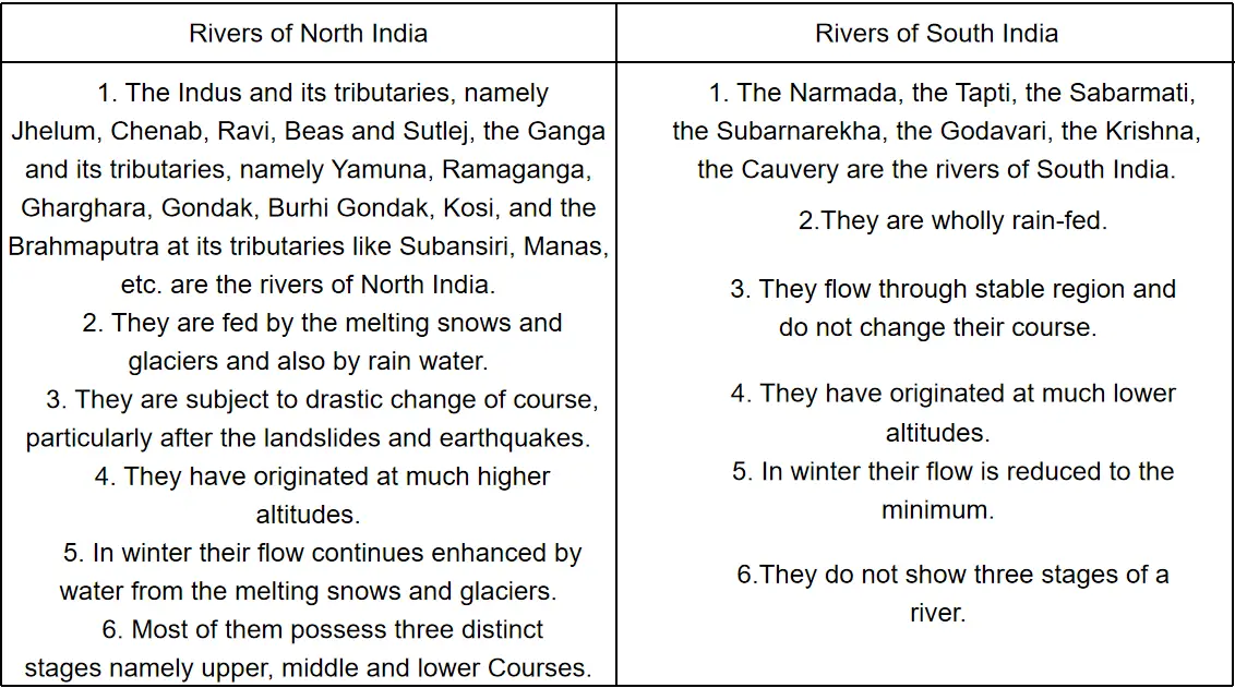
Question 1. State the differences between the physical characteristics of North and South Indian rivers.
Answer:
The differences between the physical characteristics of North and South Indian rivers
Question 2. What do you know about the Arabian Sea drainage or the west-flowing rivers of India?
Answer:
The west-flowing rivers of India are:
(1)The Narmada (1,282 km): It rises from the Amarkantak peak of the Mahakal range and flows through the rift valley in between the Vindhyas and the Satpura range in the West and drains into the Gulf of Khambat. It makes a beautiful waterfall on the marble rocks named Dhauladhar at Bhorghat near Jabalpur.
(2)The Tapti (740 km): Tapi is also known as the Tapti river; it rises from the Mahadeo range and flows in a rift valley lying between the Satpura and Ajanta ranges towards the West. It drains into the Gulf of Khambat. The Surat port is situated in its mouth.
(3)The Mahi (503 km): It rises from the Vindhyan range. It flows northwards at first and then takes the southwestern course to join the Gulf of Khambat. Most of its course lies in Gujarat state.
(4)The Sabarmati (416 km): It rises from the Aravalli range and drains into the Gulf of Khambat flowing in the southwest direction. The major portion of its basin lies in the Gujarat state.
“WBBSE Solutions for Geography Class 10 Drainage of India MCQs and answers”
Other rivers: Other notable rivers are Amba, Sabitri, Sharavati, Bagabati, Saraswati, etc. Jog falls of Sharavati river is famous in India. It is the largest waterfall in the country.
Question 3. Compare and contrast the rivers of North India with that of South India.
Answer:
Difference between the rivers of North India and those of South India.
| Rivers of North India | Rivers of South India |
| Names of Rivers | |
| 1. The Indus and its tributaries, namely | 1. The Narmada, the Tapti, the Sabarmati, the |
| Jhelum, Chenab, Ravi, Beas and Sutlej. | Subarnarekha, the Godavari, the Krishna, the |
| The Ganga and its tributaries, namely | Cauveryarethe rivers of South India. |
| Yamuna, Ramaganga, Gharghara, Gondak, | |
| Burhi Gondak, Kosi, and the Brahmaputra | |
| at its tributaries like Subansiri, Manas, etc. | |
| are the rivers of North India. | |
| Source of Water | |
| 2. They are fed by the melting of snow and | 2. They are wholly rain-fed. |
| glaciers and also by rainwater. | |
| Change of course | |
| 3. They are subject to drastic changes of | 3. They flow through the stable region and do not |
| course, particularly after the landslides | change their course. |
| and earthquakes. | |
| Altitude at source | |
| 4. They have originated at much higher | 4. They have originated at much lower altitudes. |
| altitudes. | |
| Winter Flow of Water | |
| 5, In winter their flow continues to be enhanced | 5. In winter their flow is reduced and is to the minimum. |
| by water from the melting snow and glaciers. | |
| Stages of River Course | |
| 6. Most of them possess three distinct stages | 6. They do not show the three stages of a river. |
| namely upper, middle and lower courses. | |
| Navigability | |
| 7. The middle and lower courses of these | 7. Most of them are swift-flowing. They are |
| rivers are navigable. | navigable at the lower course. |
| Flood plain, etc. | |
| 8. They have developed a vast floodplain. | 8. They have not formed any floodplain |
| The Ganga has formed the largest delta | except for the deltaic plains. Of the west flowing |
| at its mouth. | rivers like.the Narmada and the Tapti do |
| Meanders | |
| 9. The rivers of North India drain areas | 9. The rivers of South India drain areas which . |
| which are comparatively unstable geology- | are comparatively more stable geologically |
| logically and form meander. | and are devoid of meanders. |
| Drainage | |
| 10. (a) The rivers of North India may broadly | 10. (a) The rivers of South India may |
| be divided into the Bay of Bengal drainage | be divided broadly into the Bay of Bengal |
| and the Arabian Sea drainage. The Ganga | drainage, the Arabian Sea drainage and the |
| system and the Brahmaputra system | Geosyncline drainage. The Mahanadi, the |
| belong to the former and the Indus system | Godavari, the Krishna, and the Cauvery be |
| to the latter. | long to the Bay drainage. The Narmada, the |
| Tapti, the Sabarmati belong to the Arabian | |
| Sea drainage. The Chambal, the Betwa, the | |
| Son form the Geosyncline drainage. | |
| (b) The Himalayas through its magnificent | (b) The Godavari, the Krishna, and the Cau- |
| gorges, rising sometimes to more than 5 | very systems are examples of superimposed |
| km (Near Bunji) exhibits exemplary ante- | drainage pattern. |
| cedent drainage. The deep gorges cut | |
| across the Himalayas provide momentum | |
| to the major rivers of North India. | |
| (c) The rivers of North India are well | (c) The rivers of South India present const- |
| integrated and reveal a generalised dendritic | recited drainage owing to the faults, dykes |
| pattern. The drainage pattern resembles | quartz veins on the Peninsular foreland. |
| the branching of a tree. |
Question 4. Describe the course of the east-flowing rivers of south India.
Answer:
The course of the east-flowing rivers of south India
1. Godavari (1465 km.)It is sometimes called the Ganga of the South. It rises from the Trambak Highlands of the Western Ghat ranges near the Nasik district of Maharashtra. It then flows southeastward and drains into the Bay of Bengal. It forms a large delta on its mouth after dividing itself into a number of distributaries. Indravati, Pengona, Wenganga, Pranhita, and Manjira are some of the important tributaries of Godavari.
2. SubarnarekaIt rises from the Chotanagpur plateau of Bihar and flows eastwards to drain into the Bay of Bengal near the Br are coast of Orissa.
3. MahanadiMahanadi rises froi n Sihawa Highlands of Raipur district of Madhya Pradesh. It flows through the Chattisgarh region and drains into the Bay of Bengal. It forms a large delta on its mouth. Brahmani and Baitarani are the two main tributaries of the river.
4. Krishna Krishna rises near Mahabaleshwar peak and drains into the Bay of Bengal. Bhima, Tungabhadra, Bedbati, etc. are its important tributaries. It forms a delta on its mouth.
5. The Kaveri The Kaveri (Cauvery) rises from the Brahmagiri Hills of Western Ghats near Coorg of Karnataka. It flows eastwards crossing the Ghats. The Timbavati, Bhavani, Shimla are the main tributaries of the Kaveri. After forming a delta, it flows into the Bay of Bengal. The Kaveri delta is very much fertile and known as the ‘Granary of the South’. Other rivers The other east-flowing rivers of South India are Paller, Penner, Ponnaiyer, Vaigai, Chittar, and others. These rivers flow into the Bay of Bengal.
Question 5. Give an account of the course, tributaries, and distributaries of the river Ganga.
Answer:
Ganga:
The course of the Ganga: The main river of India is the Ganga. It stretches for 2510 km, but 2017 km of its length lies in India and the remainder lies in Bangladesh. The river can be divided into 3 parts from its source to its mouth.
They are: 1. Upper course of the Ganga, 2. Middle source of the Ganga and 3. The lower course of the Ganga.
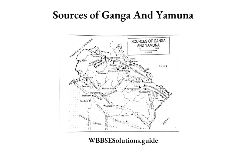
1. Upper Course of the Ganga river: The river rises from the Gomukh ice cave at the snout of the Gangotri Glacier at a height of nearly 6600 m. The glacier lies in the Great or Himadri Himalayas, lying in Uttar Pradesh. Near its source, the river is known as Bhagirathi which also forms the main tributary of the Ganga. The Bhagirathi forms narrow V shaped valleys in the Himalayas while flowing to the southwest.
Near Devprayag it meets another important tributary of the Ganga called Alokananda. Higher in the mountains, to the north-east, Alokananda merges with another tributary of the Ganga, river Mandakini at Karnaprayag, and Bhagirathi or Ganga and the Alokananda river is called the Ganga-river, which flows over the Shivalik (Siwalik) ranges southwards, until it reaches the plains at Haridwar. Thus from the source to Haridwar lies the mountain course or upper course of the Ganga.
Any river that shows the dominance of erosive activity in the mountain or upper course and the dominance of deposition activity in the delta or lower course, is called an ideal river. The course of the river Ganga shows these characteristics clearly, so the river Ganga is called an ideal river.
2. Middle course of the river Ganga: The Ganga river initially flows southwards from Haridwar and then turns to the east flowing over the states of Uttar Pradesh and Bihar. Near the Rajmahal hills in Bihar, the Ganga takes another southward curve and enters into the state of West Bengal. The length of the Ganga from Haridwar to the Rajmahal hills forms the Plains or Middle Ganga Plain region.
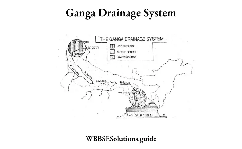
3. The delta or lower course of the Ganga: The Ganga river moves around the Rajmahal hills to the east and then turns south to enter the state of West Bengal. So the river enters West Bengal and then near Dhulian in Murshidabad it divides into the Padma and Bhagirathi distributaries. The main distributary of the Ganga is called Padma initially, and later it is called Meghna before it drains into the Bay of Bengal. The feebly flowing second distributary is called Bhagirathi-Hugli, which flows through West Bengal to drain into the Bay of Bengal. The course of the Ganga between the Rajmahal hills and its mouth near the Bay of Bengal is called the lower course or Delta course of the Ganga. The largest delta in the world has been formed by the Ganga at its mouth.
Tributaries of the Ganga river: The main tributary of the Ganga is Yamuna. It rises from the snout of the Yamunotri Glacier in Uttar Pradesh. It meets the Ganga at Allahabad; it is also called Prayag. Some important tributaries of the Yamuna are Chambal, Betwa, Ken, etc. They all rise from the Central Highlands to the south of the Northern Plains and are fed by rainwater. Yamuna forms the main snow-fed and right bank tributary of the Ganges. Some other tributaries of the Ganga are Ramganga, Gomati, Ghaghara, and Gandakand Kosi. These rivers join Ganga on its left bank and are all fed by the snowmelt waters of*the Himalayas. Among other right bank tributaries of the Ganga rising from the southern plateau, the most important is Son. It is rain-fed. Some tributaries of the “Bhagirathi-Hugli distributary of the Ganga river are— Damodar, Mayurakshi, Ajay, Rupnyarayan, etc. They are all rain-fed.
Distributaries of the Ganga river: Near Dhulian in the Murshidabad district of West Bengal, the Ganga river divides into two distributaries-Padma and Bhagirathi- Hugli. When the Bhagirathi-Hugli flows past the district of Hugli, it is called the Hugli river. According to some views, the intrusion of saline water from the sea at high tide is the part of this river which is called Hugli. The distributaries of the Bhagirathi-Hugli are Bhairab, Jalangi, Bidyadhari, Mathabhanga, etc.
Other characteristics of the Ganga: The Ganga river shows various features-‘V’ shaped valleys, wide valleys, meandering course, ox-box lakes, flood plains, natural levees, deltas, etc. along its course from source to mouth. Ganga contributes 14% of the total water flow in India. The Ganga basin has 26% of the total hydroelectric potential of India. Many famous towns and market centres are located on the banks of the Ganga, such as— Haridwar, Allahabad, Kanpur, Benaras, Kolkata, Patna, etc.
Question 6. Give a brief account of the river Brahmaputra.
Answer:
1. The course of the river Brahmaputra: The Brahmaputra is the most important river in Eastern India. It rises from the Chemayang Dung Glacier which is located 90 km southeast of the Rakhas Tal and Manasarovar in Tibet. From this source, Brahmaputra flows eastwards for nearly 1500 km in Tibet. Here the river is known as Tsangpo. Near Namcha Barwa peak the Brahmputra makes a southward turn, cuts across the Himalayas, and enters Arunachal Pradesh where it is called Dang. The Dihang enters Assam near Sadiya to meet the Lohit river and Dibang river.
These 3 rivers join and flow through Assam from the northeast the west and is called the Brahmaputra river. At Dhubri in western Assam, the Brahmaputra takes a southward turn and enters Bangladesh where another tributary the Tista meets it from India. The combined water is then called Jamuna in Bangladesh. Further south the Jamuna meets the Padma and they together drain into the Bay of Bengal. The total length of the Brahmaputra river is nearly 2580 km, of which in India only 885 km flow.
2. Tributaries of the Brahmaputra: Dibang and Lohit are the most important tributaries of the Brahmaputra. The other tributaries are Subansiri, Bharali, Torsa, and Tista which join it on its right bank, while on its left bank, Buridihi, Dhansiri, Kopili, etc. tributaries join it.
3. Other characteristics of the Brahmaputra: The Brahmaputra river flows slowly over the Assam valley due to the gentle slope of the land. Thus the river flows through pronounced meanders and has many sandbanks and islands along its channel. The largest river island in the world lies on this river and is called Majuli island. This island has an area of about 929 sq km. Frequent earthquakes in the Assam valley have caused the Brahmaputra to change its course quite often.
Question 7. Give an account of the distribution of lakes and other water bodies.
Answer:
Lakes, water bodies, and canals are distributed all over India. A brief discussion of these water bodies is given below:
Lakes: Lakes are of two types in India:
1. Lakes of the Himalayas and North India, and
2. Lakes of south India
| Type of Lake | Names of Lakes | State/where found | Nature of lake |
| Himalayan and North Indian Lakes | Nainital, Sattal, Bheematal, Punatal, Khurpa Tal | Kuman Himalaya, U.P. | Freshwater Lake |
| Dal lake, Wular lake, Harnag, Dudhnag | Kashmir Himalaya | Freshwater lake | |
| Tso Moriri, Saltlake Pangong lake | Ladhak | Brackish water lake | |
| Logtak lake | Manipur | Freshwater lake | |
| Sambhar, Didwana Chapper, Kachar | Rajasthan | Brackish water lake | |
| Lakes of South India | Lunar lake | Maharashtra | Crater lake (brackish water lake) |
| Chilika lake | Coastal Bay of Bengal Odisha | Largest brackish water lake in India | |
| Kolleru lake | In between Godavari and Krishna delta in Andhra Pradesh | Freshwater lake | |
| Pulicat lake | Tamil Nadu | Brackish water lake | |
| Vembanad, Astamudi Kayals | Malabar coast of Kerala | Brackish water lake |
Among the water bodies of India reservoirs, tanks, ponds, beels, ox-bow lakes derelict water, and brackish water cover about 7 M Ha of area. The southern States of Andhra Pradesh, Karnataka, Tamil Nadu along with West Bengal, Rajasthan, and Uttar Pradesh account for 62% of the total area under tanks and ponds, and reservoirs in the country. More than 77% of bees, oxbow lakes, and derelict water lies in the states of Odisha, U.P., and Assam. Brackish water is found in Odisha, Gujarat, Kerala, and West Bengal.
The total reserve of inland waterbodies in India is unevenly distributed though the majority of them lie in the states of Odisha, Andhra Pradesh, Gujarat, Karnataka, and West Bengal. Uttar Pradesh occupies the first place with the total length of rivers and canals as 31.2 thousand km which is about 17% of the total length of rivers and canals in the country. Other states following Uttar Pradesh are Jammu and Kashmir and Madhya Pradesh. Some important canals of India are the west-Yamuna canal, Upper Ganga canal, Lower Ganga canal of U.P., Hijli canal, Medinipur canal, canals of Damodar, Mayurakshi, Kasai, canals of Rajasthan in North India and canals of the rivers of South India.
Question 8. Write the importance of river bodies from a human perspective.
Answer:
Important of River Bodies from a Human Perspective: Rivers, lakes, ponds, reservoirs, canals, etc. are important from a human perspective because of the following reasons:
1. They provide fresh water which is best to use for drinking,
2. They supply water for agricultural, domestic, and industrial uses,
3. These water bodies produce power in the form of hydropower, hydroelectric and thermoelectric,
4. They are natural wildlife habitats for many different species,
5. Lakes and ponds regulate soil formation, biodiversity, groundwater recharge, and flood,
6. They are most commonly used for recreation like swimming, boating, fishing, nature viewing, etc.
7. They supply irrigation water to the agricultural fields.
8. They have moderating influence on the climate of surrounding regions,
9. As parts of the hydrological cycle they help in maintaining balance in nature.
Question 9. What do you understand by the overuse of groundwater? State its impacts.
Answer:
Overuse of groundwater and its impact: Groundwater is the largest source of usable fresh water. It is widely used in areas deficient in surface water. Groundwater is readily used in domestic, agricultural, and industrial fields. Sustained groundwater pumping causes depletion of its level. In India, the number of wells showing a fall in groundwater level is 5,699 (2003-12) according to reports from the Ministry of Water Resources. The states where the groundwater table has declined considerably are Tamil Nadu (76%), Punjab (72%), Kerala (71%), Karnataka (69%), Meghalaya (66%), Haryana (65%), West Bengal (64%) and Delhi (62%).
Some of the adverse effects of groundwater depletion are:
1. Lowering of the water table,
2. Increased cost for pumping farther to reach the water table,
3. Reduced surface water supply, as groundwater and surface water are connected with each other,
4. Land subsidence occurs when there is a loss of support belowground,
5. Excessive pumping in coastal areas causes salt water to move inland resulting in contamination of the water supply.
Question 10. Write what do you know about Damodar Valley Corporation.
Answer:
Damodar Valley Corporation: The River Damodar (in Eastern India) was known for frequent floods resulting in the destruction of life and property. The river runs 541 km from its origin in the Khamerpet Hills in the eastern part of India, to meet the river Hugli. The basin area is 17,506 sq. km. The corporation was jointly formed by the government bodies: the Central Government, the Government of West Bengal, and the Government of Bihar (presently Jharkhand) to participate jointly for the purpose of building the Damodar Valley Corporation. The Damodar runs through some of the most mineral-rich regions of India. The basin provides the country with valuable minerals, such as coal and iron ore. There is also considerable agriculture in the region, with rice and potatoes being the major crops.
The river Damodar is entirely rain-fed. About 80% of the annual discharge occurs during the four monsoon months from June to September. This seasonality and the consequent imbalance in its flow had resulted in frequent flash floods, which gave the Damodar its epithet – River of Sorrow. To tame the violent river, a scheme was launched in the 1950s and the Damodar Valley Corporation came into being. The scheme essentially involved the construction of dams along the length of the river, so that the flow remained a part of the total system of water management. DVC dams are capable of moderating floods of 6.51 lac cusec to 2.5 lac cusec. With time DVC developed six thermal power stations at Bokaro.
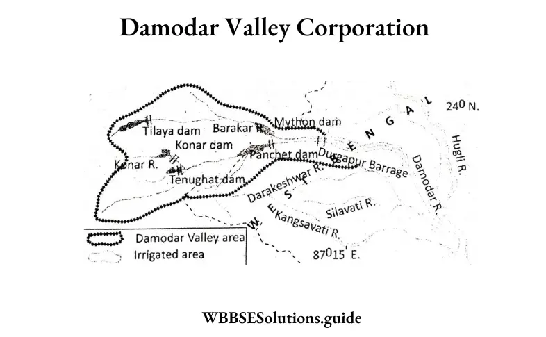
Chandrapura and Durgapur, three hydroelectric power stations at Tilaiya, Maithon, and Panchet with a capacity of 144 MW, and one gas turbine station with a capacity of 82.5 MW. Presently DVC has 35 sub-stations and also four dams, a barrage, and a network of canals that play an effective role in water management. The construction of check dams, development of forests and farms, and upland and wasteland treatment developed by DVC play a vital role in eco-conservation and environment management. A flood reserve capacity of 1292 mcm has been provided in 4 reservoirs. Water is stored in the 4 DVC reservoirs to supply 680 cusecs of water to meet industrial, municipal and domestic requirements in West Bengal and Jharkhand. A barrage on river Damodar was constructed in 1955 at Durgapur to supply of irrigation water to the districts of Burdwan, Bankura, and Hooghly in West Bengal.
“Drainage of India WBBSE Class 10 question answers PDF”
Question 11. What do you mean by watershed management and rainwater harvesting?
Answer:
Watershed and watershed management: The highland that separates two adjacent river catchment areas is called a ‘watershed’. They are important because the flow of water in the catchment area, the speed, and volume of water, the amount of silt generated, etc. depend on the nature of the watershed. They are natural highlands that influence the characteristics of rivers and their basins. But sometimes they are manipulated by ‘watershed management’.
This refers to the scientific use and utilization of water resources to stop soil erosion, increase fertility, control floods, prevent siltation of river beds, and maintain proper land use patterns. Some methods of watershed management are strip cropping, grassland farming, terracing, construction of check dams, construction of farm ponds, etc. E.g.- the Kothapally watershed management program (1999) in Andhra Pradesh-this program has taken up soil and water management programs, enhanced crop and livestock farming, increased income levels, increased greenery, and decreased soil run-off.
Rainwater harvesting: Rainwater harvesting is the accumulation and storage of rainwater for reuse rather than allowing it to run off. Its uses include harvesting water for gardening, livestock, irrigation, domestic use, etc. It can also be used as drinking water.
Advantages: Rainwater harvesting provides an independent water supply during regional water restrictions like droughts. It can mitigate flooding of lowlands. It helps to sustain groundwater levels. It ensures the availability of potable water, is clean and free from salinity.
Question 12. Write the role of Tamil Nadu in rainwater harvesting.
Answer:
Rainwater Harvesting in Tamil Nadu: The Rainwater Harvesting movement launched in 2001 was the brainchild of the Honourable Chief Minister of Tamil Nadu. It had a tremendous impact in recharging the groundwater tables all over Tamil Nadu. According to Building Rules 1973, it is made mandatory to provide Rainwater Harvesting (RWH) structures in all new buildings. Town Panchayats had undertaken the construction of new RWH structures and the renovation of old structures. Out of 23,92,457 buildings in Town Panchayats about 22,94,342 buildings are provided with Rainwater Harvesting facilities. Awareness programs, the erection of hoardings displaying the importance and benefits of RWH, and participation of NGOs were action plans of this program. RWH structures have been provided to buildings that belong to Town Panchayat departments.
Two techniques of RWH were followed:
1. Storage of rainwater on the surface for future use.
2. Recharge of groundwater: For storage, the structures used are: pits (for recharging shallow aquifers), trenches (depending on the availability of permeable streams), dug wells, hand pumps, recharge wells, etc. Water in secure households or individuals are the ones to benefit the most from Rainwater Harvesting in the state. This program is thus visualised to improve water supply, food production, and food security for the people of Tamil Nadu.
Question 13. What are the drawbacks of the conventional method of irrigation?
Answer:
Drawbacks of Conventional Method of Irrigation: Conventional irrigation systems suffer from a number of constraints leading to improper utilization of water. These are the following:
1. In the conventional system of irrigation a large quantity of water is not properly utilised.
2. Crops are usually subjected to cyclic changes of flooding and water stress situations, by providing heavy irrigation at one time and leaving the fields to dry up for about 10 to 15 days. The moisture availability to the crops, therefore, keeps on changing. This results in poor yields in the crops.
3. The fields situated in low areas always get excess water causing prolonged water Egging. Thus, crops are subjected to water logging resulting in poor yields.
4. In the fields about 10-15 percent of land is utilized for preparing channels and distributions, etc. which decreases the effective area of cultivation.
5. Extensive areas of land in the arid and semi-arid regions of India have gone out of cultivation due to the accumulation of salts. Excessive irrigation and poor water management are the main reasons of water logging and gradual build up of excessive salts. Progressive build-up of soil salinity has made the soils unsuitable for cultivation.
Question 14. How did the Indian river system evolve?
Answer:
Before we proceed to know about the present nature of the drainage system, it is necessary to understand its evolution. The present drainage of India is the result of the long process of evolution. Two broad divisions of the drainage of India can be recognised on the basis of their evolution.
They are:
1. The Himalayan rivers, and
2. The Peninsular rivers.
The Himalayan Rivers: Three major rivers of the Himalayas-the Indus, the Ganga, and the Brahmaputra- originate on the southern slopes of the Tibetan Highlands. They first flow parallel to the mountains and then take a sudden bend towards the south cutting deep gorges in the Himalayan ranges. The gorges of the Indus, Satluj, Alaknanda, Gandak, Kosi, and Brahmaputra clearly indicate that these rivers existed even before the Himalayan ranges were formed. These rivers continued to flow by cutting the mountain ranges as these ranges rose, leading to the formation of deep gorges. Thus, the Himalayan rivers are typical examples of antecedent drainage.
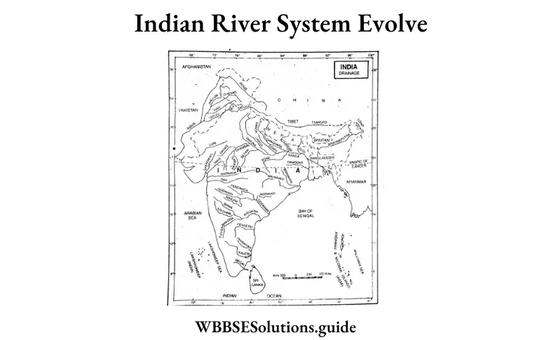
The Indobrahm Theory: According to geologists, the Shiwalik hills run parallel to the main Himalayan ranges and are formed of alluvial deposits consisting of sands, clays, and boulder conglomerates. These deposits were laid down by a mighty stream that flowed from Assam to Punjab and even beyond upto Sind. It finally emptied itself into a gulf that occupied parts of Sind and lower Punjab in the Miocene period. This stream is known as the ‘Indobrahma’ or the ‘Shiwalik’ river. This river carried the combined flow of the three main rivers—the Indus, the Ganga, and the Brahmaputra—and deposited huge quantities of alluvium. Later.
This mighty stream dismembered into the following systems and sub-systems:
1. The Indus,
2. The five tributaries of the Indus in Punjab,
3. The Ganga and its Himalayan tributaries, and
4. The stretch of the Brahmaputra in Assam and its Himalayan tributaries.
The dismemberment was the result of the following two events:
1. Upheavals in the western Himalayas including the Potwar Plateau in the Pleistocene age.
2. Headward erosion by the tributaries of the Indobrahma river.
As a result of the above-mentioned dismemberment of the Indobrahma river, the Indus and its tributaries, the Ganga and its tributaries, and the Brahmaputra and its tributaries came into being. It is supposed that the Yamuna was first a tributary of the Indus, but it was annexed by the Ganga later on and it became a tributary of the Ganga.
Geography Class 10 Solutions WBBSE
The Peninsular Rivers: The broad, graded, and shallow valleys of the Peninsular rivers indicate that these rivers existed much before the Himalayan rivers came into being. These rivers have acquired maturity and do-mostly lateral cutting instead of vertical cutting. Most of the rivers flow from west to east with notable exceptions of Narmada and Tapi, These two rivers flow in troughs which have not been formed by them. The Western Ghats used to form the original watershed. But, due to the submergence of the western flank of the Peninsular block, the general symmetry of the Peninsular rivers was disturbed. The second distortion took place at the time of the formation of Himalayan rivers when the northern flank of the Peninsular block suffered subsidence and, consequently, trough-faulting took place. The Narmada and the Tapi flow in such trough faults and represent consequent drainage.
Question 15. Write the merits and demerits of canal irrigation.
Answer:
Merits of Canal Irrigation:
1. Most of the canals provide perennial irrigation and supply water as and when needed.
This saves the crops from drought conditions and helps in increasing farm production.
2. Canals carry a lot of sediment brought down by the rivers. This sediment is deposited in the agricultural fields which adds to the fertility of the soil.
3. Some of the canals are parts of multipurpose projects and, therefore, provide a cheap source of irrigation.
4. Although the initial cost involved in canal irrigation is much higher, it is quite cheap in the long run.
Demerits of Canal Irrigation :
1. The canal water soaks into the ground and leads to the problem of water-logging along the canal route.
2. Excessive flow of water in the fields raises the groundwater level. Capillary action brings alkaline salts to the surface and makes large areas unfit for agriculture. Vast areas in Punjab, Haryana, and Uttar Pradesh suffer from the problem of ‘reft caused by canal irrigation. About 36,000 hectares have been rendered useless in Nira Valley of Maharashtra due to high concentration of salts in the soil resulting from canal irrigation.
3. The marshy areas near the canals act as breeding grounds of mosquitoes which result in widespread malaria.
4. Many canals overflow during the rainy season and flood the surrounding areas.
5. Canal irrigation is suitable in plain areas only.
Question 16. Explain why deltas are not formed at the mouth of the west-flowing rivers of India.
Answer:
The slope of the Western Ghats is steep and that is the reason that these rivers have a rapid flow. They don’t have to travel much distance to drain into the sea. As a result, they don’t carry many sediments required to form deltas.
1. The eastward slope consists of the Deccan plateau. In other words, the western coast is higher when compared to the eastern coast. Thus there is no ground presented for delta-based formation.
2. The west-flowing rivers come from the western ghat. The western coast consists of hard rocks. So it is not possible.
3. The hard rocks don’t allow west-flowing rivers to widen their mouth. Hence they formed estuaries instead of deltas.
Question 17. Why is irrigation necessary in Indian agriculture?
Answer:
Agricultural crops need water for their growth. In India, the monsoon is the main source of rainfall. But the monsoon in India has many drawbacks, viz.
1. Uncertainty With regard to time and place, the monsoon rainfall is uncertain.
2. Irregular distribution of rainfall throughout the year is irregular.
3. Excessive and scanty rainfall in some areas excessive rainfall causes floods, whereas in others, scanty or no rainfall causes droughts.
4. Soils In some areas, soils have less water retaining capacity, so irrigation is needed.
5. For winter crops irrigation is a necessity because most of the monsoon rain falls in summer.
6. Irrigation is needed for some plants that are thirsty like jute, and paddy. ‘
7. To increase the yields, chemical fertilizer is essential and for this irrigation is necessary.
8. To feed the ever-rising population, crops should be grown throughout the year, hence irrigation is necessary.
Class 10 WBBSE Geography Drainage of India important questions”
Question 18. Mention the different irrigation systems practiced in India.
Answer:
The following methods are used for irrigation in India:
1. Wells: Wells are mainly used in areas having a large quantity of groundwater where it is tapped by digging down to the water table. Deeper wells irrigate larger areas and are lined with bricks, so we call them pucca wells. Irrigation by wells is done in U.P., Punjab, Haryana, Bihar, West Bengal, Andhra Pradesh, Tamil Nadu, and Maharastra because the soil there is soft and porous and sub-soil water is near the surface of the earth. There are about 50 lakh wells in India. About 25% of the total irrigated area is irrigated by wells.
2. Tube-wells: These consist of a deep bore dug into the ground with drilling equipment and water is drawn out with the help of a pump. Tube wells have proved very useful in the alluvia! plains of Punjab, Haryana, U.P., and Bihar. U.P. leads in tube-well irrigation. There are about 31,000 tube wells in the country and they irrigate about 60 lakh hectares of land. About 23% of the total irrigated area in India is served by tube- wells. In this way, wells and tube wells account for (25% + 23% = 48%) of the total irrigated area in India.
3. Canals: A canal is a big water channel taken out of a river and further divided into small distributaries in order to lead the river-water to the fields. About 45% of the total irrigated area is watered by canals. U.P., Punjab, Andhra Pradesh, Haryana, West Bengal, and Tamil Nadu are the leading states which use canal irrigation. These six states are having about 75% of the total canal-irrigated land.
There are two types of canals in India :
1. The inundation Canals: The inundation canals are those which flow during the rainy season when the rivers are in flood. These are simple but do not provide water all year round. These canals irrigate about 6% of the total irrigated area.
2. Perennial Canals: They draw their water from perennial rivers of artificial lakes. They are very useful for irrigation all throughout the year. They irrigate about 39% of the total irrigated area. Some of the important canals are the Western and Eastern Yamuna canals, Sirhind canals, Upper Bari Doab canals, Upper Ganga canals, etc.
Question 19. What do you mean by canal irrigation? Mention the areas where canal irrigation is found in India.
Answer:
Canal irrigation
India has one of the world’s largest canal systems stretching over more than one lakh kilometres. The irrigation canals are of two types:
1. Inundation Canals: These canals are taken out directly from the rivers without constructing any barrage or dam. Such canals use the excess water of rivers at the time of floods and remain operational during rainy season. As the beds of these canals are at a level higher than those of the rivers, they get supply of water only when the rivers are in flood. Therefore, these canals have limited use.
2. Perennial Canals: These canals are taken out from the perennial rivers by constructing barrages to regulate the flow of water. Most of the canals in India belong to this category. Canal irrigation is in practice in Uttar Pradesh, Madhya Pradesh, Andhra Pradesh, Rajasthan and Haryana, Jammu and Kashmir, Assam, and Tripura. Canals also supply water to a sizeable part of the irrigated area in Bihar, Orissa, Karnataka, Tamil Nadu, and West Bengal. Mizoram, the least irrigated state, is solely dependent on canals. The northern Great Plains have elaborate system of canals.
Important canals in Punjab: Haryana is Upper Bari Doab, Bist Doab, Sirhind, Bhakra, and Western Yamuna canals. The Indira Gandhi canal, Bikaner canal, and the canals of the Chambal projects are major canals in Rajasthan. Canals in Uttar Pradesh include the Eastern Yamuna Canal, Sharda canal, Ramganga canal, and Betwa canal. In south India, the canals of the Nizamsagar, NagarjunasagarandTungabhdra projects and of the Krishna and Godavari deltas are the major ones. In Tamil Nadu, nearly one-third of the net irrigated area is under canal irrigation.
Question 20. What are the advantages and disadvantages of tube-well irrigation?
Answer:
Advantages of Tube-well Irrigation:
1. A tube well can irrigate about ten times more area than an ordinary well.
2. It is operated by an electric motor or by a diesel engine and water can be easily lifted from greater depths.
3. It is the most suitable source of irrigation in areas where canal irrigation is not available.
4. A tube well is an independent source of irrigation and can be used by the farmer whenever the crops need water.
5. Several chemicals are mixed with tube-well water. Such chemicals add to the fertility of the soil.
“WBBSE Geography and Environment Drainage of India solutions PDF”
Disadvantages of Tube-well Irrigation:
1. Although it can irrigate a much larger area than an ordinary well, a tube well can irrigate only a limited area which is much less than the area irrigated by canals.
2. The farmer has to spend money regularly on electricity or diesel.
3. This source of irrigation is not fit for areas of brackish groundwater.
4. A tube well can draw a much larger quantity of water. Thus the groundwater level goes down and large-scale depletion of groundwater takes place. The groundwater level has already gone critically down in several areas of Punjab and Haryana where rice culture, requiring larger quantities of water, has become popular during the last few years.
5. In the event of drought the groundwater level falls critically below the required level and the water is not available when it is needed the most.