WBBSE Solutions For Class 10 Physical Science And Environment Chapter 4 Thermal Phenomena

WBBSE Class 10 Physical Science Solutions

Chapter 4 Thermal Phenomena MCQs

Question 1. What is the S.I. unit of Heat?

  1. Joule
  2. Calorie
  3. Kelvin
  4. Celsius

Answer: 1. Joule

Question 2. Two spheres made of material have radii in the ratio of 1: 2. Both are at the same temperature. The ratio of heat radiation energy emitted per second by them is :

  1. 1:2
  2. 1:8
  3. 1:4
  4. 1:16

Answer: 2. 1:4.

Question 3. The total number of divisions present in the fundamental interval of the Celsius scale is :

  1. 80
  2. 180
  3. 100
  4. 120

Answer: 3. 100.

Read And Learn More: WBBSE Solutions For Class 10 Physical Science And Environment

Question 4. 1 Calorie is equal to :

  1. 4.2J
  2. 4.2 erg.
  3. 1J
  4. 1.8 k

Answer: 1. 4.2J

Physics Class 10 WBBSE

Question 5. The rate of cooling at 600 K, if the surrounding temperature is 300k is R, The rate of cooling at 900 K is :

  1. \(\frac{16}{3} R\)
  2. 2R
  3. 3R
  4. \(\frac{2}{3} R\)

Answer: 1. R.

WBBSE Solutions For Class 10 Physical Science And Environment Chapter 4 Thermal Phenomena

Question 6. If Im denotes the wavelength at which the radiative emission from a black body at a temperature TK is maximum, then

  1. λm α T
  2. λm α T2
  3. λm does not depend on T
  4. λm α T-1

Answer: 4. λm α T-1

Question 7. A body cools from 50°C to 40°C in 5 minutes. Its temperature comes down to 33.33°C in the next 5 minutes. The temperature of the surroundings is :

  1. 15°C
  2. 20°C
  3. 25°C
  4. 10°C

Answer: 2. 20°C.

Physics Class 10 WBBSE

Question 8. The volume of water is minimum at :

  1. 4°C
  2. 10°C
  3. 5°C
  4. 9°C

Answer: 1. 4°C.

Question 9. The density of water is maximum at :

  1. 40°C
  2. 4°C
  3. 10°C
  4. 25°C

Answer: 2. 4°C.

Question 10. The coefficient of linear expansion of a solid depends on :

  1. Unit of length
  2. Scale of temperature
  3. Density of the material
  4. None of these

Answer: 2. Scale of temperature.

Question11. A good insulator of heat is:

  1. Copper
  2. Mercury
  3. Trapped air
  4. Iron

Answer: 3. Trapped air.

Question 12. A body cools from 60°C to 50°C in 10 min. If the room temperature is 25°C, the temperature of the body at the end of the next 10 min. will be :

  1. 38.5°C
  2. 40°C
  3. 45°C
  4. 42.85°C

Answer: 4. 42.85°C.

Physics Class 10 WBBSE

Question 13. A black body has a maximum wavelength Im at 2000K. Its corresponding wavelength at 3000K will be :

  1. \(\frac{3}{2} \lambda \mathrm{m}\)
  2. \(\frac{2}{3} \lambda \mathrm{m}\)
  3. \(\frac{16}{81} \lambda \mathrm{m}\)
  4. \(\frac{81}{16} \lambda \mathrm{m}\)

Answer: 2. \(\frac{2}{3} \lambda \mathrm{m}\)

Question 14. If the temperature of a block body is doubled, the wavelength at which the spectral radiancy has its maximum is :

  1. Doubled
  2. Halved
  3. Quadrapled
  4. Unchanged

Answer: 2. Halved.

Question 15. A body takes T minutes is cool from 62°C to 61°C when the surrounding temperature is 30°C. The time taken by the body to cool is 30°C. The time taken by the body to cool 46°C to 45°C is:

  1. Greater than T minute
  2. Equal to T minute
  3. Equal to \(\frac{T}{2}\)
  4. Less than T minute

Answer: 1. Greater than T minute.

Question 16. Heat given to a body which rises its temperature by 1°C is :

  1. Water equivalent
  2. Specific heat
  3. Temperature gradient
  4. Thermal capacity

Answer: 4. Thermal capacity.

Question 17. During the adiabatic process, the pressure of a gas is found to be proportional to the cube of its absolute temperature.

The ratio \(\frac{C P}{C V}\) for gas is.

  1. \(\frac{4}{3}\)
  2. 2
  3. \(\frac{5}{3}\)
  4. \(\frac{3}{2}\)

Answer: 4. \(\frac{3}{2}\)

Physics Class 10 WBBSE

Question 18. Two bars of copper having the same length but unequal cross-section are heated to the same temperature. The change in length will be :

  1. Equal in both bars
  2. More in thinner bar
  3. More in thicker bar
  4. Cannot say

Answer: 1. Equal in both bars.

Question 19. A gaseous mixture consists of 16g of Helium and 16g of Oxygen. The ratio \(\) of the mixture is :

  1. 1.54
  2. 1.4
  3. 1.63
  4. 1.59

Answer: 3. 1.63.

Question 20. The specific heat of a gas in a gas in an isothermal process is:

  1. Infinite
  2. Zero
  3. Negative
  4. Remains zero

Answer: 1. Infinite.

WBBSE Class 10 Physical Science Question Answer

Question 21. What is the upper fixed point in the Fahrenheit scale?

  1. 212°F
  2. 232°F
  3. 202°F
  4. 211°F

Answer: 1. 212°F.

Question 22. The Fahrenheit and Kelvin scales of temperature will have the same reading at :

  1. – 40
  2. 313
  3. 574.25
  4. 732.25

Answer: 1. – 40.

Question 23. At what temperature, the volume of an ideal gas at 0°C becomes triple?

  1. 182°C
  2. 819°C
  3. 546°C
  4. 646°C

Answer: 3. 546°C.

Question 24. The specific heat of ice at 0°C melting into at 0°C is :

  1. Zero
  2. Infinity
  3. More than zero
  4. Less than zero

Answer: 2. Infinity.

Question 25. Boiling water is changing into steam. The specific heat of boiling water is :

  1. Zero
  2. One
  3. Infinity
  4. Less than one
  5. Answer: 3. Infinity.

WBBSE Class 10 Physical Science Question Answer

Question 26. Which of the following has the highest specific heat?

  1. Copper
  2. Water
  3. Hydrogen
  4. Silver

Answer: 3. Hydrogen.

Question 27. One gram of ice at 0°C is added at 5g of water to 10°C. The final temperature of the mixture is

  1. -5°C
  2. 5°C
  3. 0°C
  4. None of these

Answer: 1. – 5°C.

Question 28. The specific heat of an ideal gas varies with temperature T as:

  1. T1
  2. T2
  3. T-1
  4. T0

Answer: 4. T0 .

Question 29. 22g CO2, at 27°C is mixed with 16g of Oxygen at 37°C. The temperature of the mixture is:

  1. 32°C
  2. 27°C
  3. 37°C
  4. 30°C

Answer: 1. 32°C.

Question 30. A balloon contains 500 m3 of He at 27°C and 1 atmosphere pressure. The volume of He at -3°C and 0.5 atmosphere pressure will be :

  1. 70m3
  2. 900m3
  3. 1000m3
  4. 500m3

Answer: 2. 900 m3.

WBBSE Class 10 Physical Science Question Answer

Question 31. 100g of ice is mixed with 100g of water at 100°C. The final temperature of the mixture is :

  1. 10°C
  2. 20°C
  3. 40°C
  4. 30°C

Answer: 1. 10°C.

Question 32. For making a thermometer quick-acting.

  • The bulb of the thermometer should be of greater volume
  • The bulb of the thermometer should be of less volume
  • The bulb of the thermometer should be spherical

Answer: 2. Bulb of the thermometer should be of less volume

Question 33. The water equivalent of a body is 10 kg. Its thermal capacity is :

  1. 10JK-1
  2. 1JK-1
  3. 42000J.K-1

Answer: 3. 42000 J.K-1

Question 34. The liquid whose specific heat is the highest is :

  1. Water
  2. Alcohol
  3. Kerosene

Answer: 1. Water.

Question 35. Thermal capacity of 10g. a liquid having specific heat 0.03 in the CGS system is :

  1. 3cal.°C-1
  2. 30Cal.°C-1
  3. 33.3 Cal.°C-1
  4. 30 kelvin

Answer: 1. 3 Cal. °C-1

Question 36. If the temperature of a body is increased by 36° in the Fahrenheit scale then this increase in Celsius scale will be :

  1. 20°
  2. 36°
  3. 64.8°
  4. 55.9°

Answer: 1. 20°.

WBBSE Class 10 Physical Science Solutions

Question 37. An equal amount of heat is given to two liquids A and B of equal mass. The specific heat of B is twice that of A. The ratio of the rise in temperature of A and B will be :

  1. 1:1
  2. 1:2
  3. 2:3
  4. 2:1

Answer: 4. 2:1.

Question 38. 1°C change = _______ °F Change

  1. \(\frac{9}{6}\)
  2. \(\frac{9}{5}\)
  3. \(\frac{5}{9}\)
  4. \(\frac{16}{9}\)

Answer: 2. \(\frac{9}{5}\)

Question 39. The thermal capacity of a unit mass of a body is called its :

  1. Specific heat
  2. Mass
  3. Material temperature

Answer: 1. Specific heat.

Question 40. 0°C = ________ °F

  1. 32
  2. 40
  3. – 40
  4. -32

Answer: 1. 32.

WB Class 10 Physical Science Question Answer Chapter 4 Thermal Phenomena Very Short Answer Type Questions

Question 1. What is the fundamental principle of Calorimetry?
Answer: Heat lost by lost Heat gained by a cold body.

Question 2. What is the unit of coefficient of thermal conductivity in SI?
Answer: Wm K-1.

Question 3. Name the element which is the best conductor of heat.
Answer: Silver.

Question 4. What is the absorbing power of a perfectly black body?
Answer: One.

Question 5. What is the reflecting power of a perfectly black body?
Answer: Zero.

Question 6. What is an anomalous expansion of water?
Answer: In the range of 0°C to 4°C, the volume of water decreases instead of increasing, like other liquids. This is known as anomalous expansion of water.

Question 7. What is a perfectly black body?
Answer: A body which absorbs all radiations incident it.

Question 8. By which mode does the heat reach the earth from the Sun?
Answer: Radiation.

Question 9. Can convection take place in a solid?
Answer: No, for convection a fluid medium is required.

Question 10. What is the difference between 1°C and IC°?
Answer: 1°C is a particular temperature, while 1C° is the interval of one degree Celsius of temperature.

Question 11. Which is more expansible -solid, liquid or gas?
Answer: gas.

Question 12. Is the coefficient of linear expansion possible in the case of a liquid?
Answer: No, liquid has no definite length.

Question 13. What is the value of latent heat of fusion of ice in the CGS system?
Answer: 80 Calg-1.

Question 14. Is it possible that heat is supplied to a body without changing the temperature?
Answer: Yes, during a change of state there is no change in temperature although heat is supplied.

WB Class 10 Physical Science Question Answer

Question 15. Is there any upper fixed point in the Kelvin Scale?
Answer: 273.13K, which is the triple point of water.

Question 16. What is the reading of 27°C on the absolute scale?
Answer: The reading of the temperature in the absolute scale (273 + 27) 300K

Question 17. Which liquid has the highest specific heat?
Answer: The specific heat of water is the highest.

Question 18. Of 0°C and 0°F which one is less?
Answer: Of 0°C and 0°F, 0°F is less.

Question 19. How much work is to be performed to produce 1 cal heat?
Answer: To produce 1 cal heat, 4.2 × 10⁷ erg or 4.2J work is to be performed.

Question 20. Of a liquid and a solid, whose specific heat is greater?
Answer: Usually specific heat of solids is less than that of liquids.

Physics Class 10 WBBSE Chapter 4 Thermal Phenomena Fill In The Blanks

Question 1. γr = γa  + ________.
Answer: γg

Question 2. The volume of water is minimum at _________.
Answer: 4°C.

Question 3. The density of water is maximum at __________.
Answer: 4°C.

Question 4. Carbon dioxide is a ________ gas.
Answer: Greenhouse.

WB Class 10 Physical Science Question Answer

Question 5. The unit of thermal conductivity in the CGS system is _________.
Answer: Cm2S-1.

Question 6. From Charle’s law, we find y = _________°C-1
Answer: \(\frac{1}{273}\)

Question 7. From pressure law, we find γv = _________ °C-1
Answer: \(\frac{1}{273}\)

Question 8. The specific heat of the water in the SI system is
Answer: 4200 J Kg-1 K-1.

Question 9. The unit of thermal conductivity in the SI system is _________.
Answer: Jm-1 S-1 K-1

Question 10. 1 calorie = ________ Jule.
Answer: 4.18

Question 11. Heat is a form of _________.
Answer: Energy.

Question 12. Three different types of motions are translational motion, vibrational motion and _________.
Answer: Rotational motion.

Question 13. SI unit of heat is _________.
Answer: Joule.

Question 14. Temperatures are measured with a __________.
Answer: Thermometer.

Question 15. _________ is the upper fixed point in the Fahrenheit scale.
Answer: 212° F

Question 16. Three types of expansions in solids are linear expansion, superficial expansion and _________.
Answer: Volume expansion

Question 17. Real expansion of the liquid = expansion of the vessel + _________.
Answer: Apparent expansion of the liquid.

Question 18. The specific heat of a gas in an isothermal process is :
Answer: Infinite

Question 19. The specific heat of an ideal gas varies with temperature T as ___________.
Answer: T0

Question 20. 100g of ice is mixed with 100g of water at 100°C. The final temperature of the mixture is __________.
Answer: 10°C.

Question 21. Wax _______ definite melting point.
Answer: Has no.

Question 22. The unit of latent heat in SI is
Answer: J.Kg-1

Question 23. A mixture of ice and common salt is known as ________.
Answer: Freezing mixture.

Question 24. With the increase of pressure boiling point of water _______.
Answer: Increases.

Question 25. The amount of heat required to convert 2g of water at 100°C completely into steam at the same temperature is ________.
Answer: 200 cal.

Question 26. If the air contains more water vapour then rate of evaporation _________.
Answer: Decreases.

Question 27. If 80 cal of heat is given to lg of ice at 0°C, its temperature will be
Answer: 0°C.

Question 28. _______ has the highest specific heat.
Answer: Hydrogen

Question 29. 100g. of ice is mixed with 100g of water at 100°C. The final temperature of the mixture is _______.
Answer: 10°C

Question 30. ________ is the best conductor of heat.
Answer: Silver.

Class 10 Physical Science Solution WBBSE Chapter 4 Thermal Phenomena Short Answer Type Questions

Question 1. What do you mean by heat?
Answer:

Heat: It is a form of energy which produces a sensation of warmth.

Question 2. What are the different types of solutions?
Answer:

Different types of motions are

  1. Translational motion
  2. Vibrational motion
  3. Rotational motion

Question 3. What is the definition of heat with respect to motion?
Answer:

Definition of heat with respect to motion:

Heat possessed by a body is the total thermal energy of the body and is the sum of kinetic energies of all the individual molecules forming the body due to translational, vibrational and rotational to translational, vibrational and rotational motions of molecules.

Question 4. What is temperature?
Answer:

Temperature: It is the thermal condition of a body that determines the direction of flow of heat when the body is placed in thermal contact with another body.

Question 5. What do you mean by calorie?
Answer:

Calorie

Calorie It is the quantity of heat required to raise the temperature of 1 g water through 1°C.

Question 6. What is the upper fixed point of a thermometer?
Answer:

Upper fixed point: It is the temperature of steam from water boiling under a pressure of 86cm. of mercury at sea pressure of 76 cm. of mercury at sea level and 45° latitude.

Question 7. What is the water equivalent of a body?
Answer:

Water equivalent: The water equivalent of a body is the mass of water that will be heated through one degree by the amount of heat that raises the temperature of the body through one degree.

WBBSE Solutions Guide Class 10

Question 8. What is molar-specific heat at constant pressure? (CP)?
Answer:

Molar-specific heat at constant pressure:

The molar specific heat of a gas at constant pressure (CP) is the amount of heat required to raise the heat required to raise the temperature of one mole of the gas through one degree keeping the pressure constant throughout.

Question 9. What is the lower fixed point of a thermometer?
Answer:

Lower fixed point: It is the temperature of melting ice under a pressure of 16 cm of mercury at sea level and 45° latitude.

Question 10. What is a fundamental interval?
Answer:

Fundamental Interval: The difference between the fixed point of a scale is called a fundamental interval.

Question 11. What do you mean by thermal expansion?
Answer:

Thermal Expansion: The dimension of all substances generally increases with an increase in temperature. The phenomenon is known as thermal expansion.

Question 12. What are the types of expansion in solids?
Answer:

Types of expansions in solid :

  • Linear expansions
  • Superficial expansions
  • Volume expansions.

Question 13. What is an apparent expansion of the liquid?
Answer:

Apparent expansion of the liquid: If the expansion of the liquid is measured ignoring the expansion is called the apparent expansion of the liquid.

Question 14. What is the real expansion of the liquid?
Answer:

Real expansion of the liquid: When the actual expansion of the liquid is measured by considering the expansion of the containing vessel, it is called real expansion of the liquid.

Question 15. What is the conclusion of Hope’s experiment?
Answer:

Conclusion of Hope’s experiment:

From Hope’s experiment, it is proved that water at the bottom is densest at 4°C. After a sufficiently long time, the temperature of the lower thermometer falls slightly due to loss of heat by conduction to the upper regions.

WBBSE Solutions Guide Class 10

Question 16. What is molar-specific heat at constant volume (CV)?
Answer:

Molar specific heat at constant volume (Cv): The molar specific heat of a gas at constant volume (Cv) is the amount of heat required to raise the temperature of one mole of the gas through one degree keeping the volume constant throughout.

Question 17. What is Regelation?
Answer:

Regelation: The phenomenon of melting of ice under pressure and freezing again on releasing the pressure is called regelation.

Question 18. What do you mean by the vapour pressure of a liquid?
Answer:

Vapour pressure: Whenever a liquid evaporates at any temperature, the vapour exerts a definite pressure on everything in contact. This pressure is called the vapour pressure of the liquid a that temperature.

Question 19. What is the conduction of heat?
Answer:

Conduction: It is the process of the transfer of heat through a substance without any detectable motion of the particles of the substance.

Question 20. What is the Radiation of heat?
Answer:

Radiation: It is the transmission of heat from a hot body to a cold body without the help of any medium and without appreciable heating at the intervening medium if any.

Question 21. What is the perfectly black body?
Answer:

Perfectly black body: A perfectly black body is that which absorbs completely the radiations of all the wavelengths on it.

Question 22. What is the greenhouse effect?
Answer:

Greenhouse effect: The greenhouse effect is an example of the selective absorption of heat by glass. The amount of heat transmitted through a substance depends on the temperature of the source of heat.

WBBSE Solutions Guide Class 10

Question 23. What is the convection of heat?
Answer:

Convection of heat: It is the process by which heat is transmitted through a liquid or gas from a hotter point to a colder point due to the bodily motion of the heated particles of the substances.

Question 24. What do you mean by global warming?
Answer:

Global warming: Carbon dioxide, water vapour, methane, nitrous oxide, tropospheric ozone, chloro-fluoro carbon compounds, halogens compounds etc. Increasing the amount of greenhouse gases in the atmosphere, the temperature of earth increases, It is known as global warming.

Question 25. What is the thermal expansion of solids?
Answer:

Thermal expansion of solids

The dimensions of all substances increase with the increase in temperature. The phenomenon is known as the thermal expansion of solids.

Question 26. Define the coefficient of linear expansion of a solid.
Answer:

The coefficient of linear expansion of a solid

The coefficient of linear expansion is defined as the fractional increase in the length of the solid per degree rise in temperature.

Question 27. How do you relate the coefficient of linear expansion of a rod with the length and temperature?
Answer:

The increase in the length of the rod due to heating is very nearly proportional to the length of the rod and the rise in temperature.

Class 10 Physical Science WBBSE

Question 28. Define the coefficient of superficial Expansion.
Answer:

The coefficient of superficial Expansion

The coefficient of superficial expansion of a solid is defined as the fractional change in its temperature.

Question 29. Define the coefficient of cubical expansion of a solid.
Answer:

The coefficient of cubical expansion of a solid is defined as the fractional increase in the volume of the solid per degree rise in temperature.

Question 30. A brass disc fits tightly into the base of the steel plate. Should you apply heat in order to remove the disc from the base?
Answer:

  • The coefficient of linear expansion of brass is greater than that of steel. So if we apply heat then the brass disc will fit more tightly into the base. But it we cool the concerned region.
  • Then the decrease in the diameter of the brass disc will be more than that of the base of the steel plate. So the disc will become loose and can be easily removed from the bore.

Question 31. Define the apparent thermal expansion of liquids.
Answer:

When the expansion is measured by ignoring the expansion of the containing vessel it is called the apparent expansion of the liquid.

Question 32. What do you mean by the coefficient of real expansion of liquid?
Answer:

Coefficient of real expansion of liquid

The coefficient of real expansion of liquid is the fraction of its volume by which it actually expands at are degree rise in temperature.

Question 33. Write the relation between the expansion coefficient of liquid. Yr = Ya + Yg.
Answer:

Relation between the expansion coefficient of liquid. Yr = Ya + Yg

Yr = Coefficient of real expansion of a liquid

Ya = Coefficient of apparent expansion of liquid

Yg = coefficient of volume expansion of the material of the vessel.

Class 10 Physical Science WBBSE

Question 34. What is a weight thermometer?
Answer:

Weight thermometer

The coefficient of apparent expansion of a liquid may be determined with a thermometer, it is called a weight thermometer.

Question 35. Power Supply lines or telephone lines are slightly sagged, why?
Answer:

Power Supply lines or telephone lines are slightly sagged,

The lines contract being cooled in winter. If they are kept taught before two plates, then due to the thermal stress. Lives may tumble or the lines may srap.

Question 36. A breaker is filled to the brain with water at 4°C. What will you notice if the temperature is decreased or increased? Give reasons for your answer.
Answer:

A breaker is filled to the brain with water at 4°C

The density of water is greatest at 4°C, and the volume of a given mass of water is least at that temperature. As the bear was filled to the brim, in both cases, the wafer overflowed from the beaker.

Question 37. The state of a fixed mass of a gas at constant temperature is inversely proportional to its pressure.
Answer:

\(V \alpha \frac{1}{p}\)

Question 38. Write the relation between the pressure and density of a gas at a constant pressure.
Answer:

The density of a gas at a constant temperature is proportional to pressure \(\frac{p}{\ell}\) = constant (P = pressure p = pressure)

Question 39. State Charles’ law.Question
Answer:

Charles’ law

The pressure remaining constant, the volume of a given mass of any gas increases or decreases by the constant fraction \(\frac{1}{273}\) of its volume at 0°C, for every degree Celsius increases or decreases of temperature.

Question 40. Define the volume coefficient of a gas.
Answer:

The volume coefficient of a gas

The volume coefficient (yp) of a gas may be defined as the fractional increase in the volume of the gas at 0°C for each degree Celsius rise in temperature, the pressure being kept constant.


WBBSE Solutions For Class 10 Physical Science And Environment Chapter 3 Chemical Calculations

WBBSE Class 10 Physical Science Question Answer In English

Chapter 3 Chemical Calculations MCQs

Question 1. Which of the following contains the least number of molecules?

  1. 1.12 LSO2 at STP
  2. 1 gm-mole SO2
  3. 32g SO2
  4. 4 x 10²³ molecules of SO2

Answer: 1. 1.12 L SO2 at STP.

Question 2. Who put forward the law of conservation of mass?

  1. Cannizzaro
  2. Lavoisier
  3. Dolton
  4. Ge Lusaka

Answer: 2. Lavoisier.

Read And Learn More: WBBSE Solutions For Class 10 Physical Science And Environment

Question 3. No. of atoms present in 3.7g. mole of nitrogen is :

  1. 4.45 x 1024
  2. 6.023 x 1024
  3. 1.204 x 1024
  4. 3.023 × 10²³

Answer: 1. 4.45 × 1024.

Question 4. The balanced equation for the chemical equation :

Ag2 SO4 + BaCl2 → BaSO4+ AgCl is:

  1. Ag2 SO4 + BaCl2 = BaSO4 + AgCl
  2. Ag2 SO2+ BaCl2 = BaSO4 + 2AgCl
  3. Ag2 SO4 + 2BaCl2= 2BaSO4 + AgCl

Answer: 2. Ag2 SO2+ BaCl2 = BaSO4 + 2AgCl

Question 5. The balanced equation for the chemical equation :

FeCl3 + SnCl2  → FeCl2 + Sn Cl4 is :

  1. Fecl3 + 2 SnCl2 = FeCl2 + 2SnCl4
  2. 2FeCl4 + SnCl2 = 2FeCl2+ SnCl4
  3. 3FeCl3 + SnCl2 = 3 FeCl2 + SnCl4

Answer: 2.  2FeCl4 + SnCl2 = 2FeCl2+ SnCl4

WBBSE Solutions For Class 10 Physical Science And Environment Chapter 3 Chemical Calculations

Question 6. NaOH + HCl = NaCl + H2O; the type of reaction is :

  1. Substitution reaction
  2. Addition reaction
  3. Neutralization reaction

Answer: 3. Neutralization.

Class 10 Physical Science Solution WBBSE

Question 7. Ammonium cyanate changes to urea on heating is an example of :

  1. Decomposition reaction
  2. Direct combination reaction
  3. Rearrangement reaction

Answer: 3. Rearrangement reaction.

Question 8. The chemical equation provides :

  1. Some information
  2. All information
  3. No information

Answer: 1. Some information.

Question 9. The balanced equation for the chemical equation

MnO2 + HCl → MnCl2 + Cl2 + H2O is:

  1. MnO2 + 2HCl = 2MnCl2 + Cl2 + H2O
  2. 2MnO2 + HCI = 2MnCl2 + Cl2 +H2O
  3. MnO2+3HCI = MnCl2+ 3Cl2 + 2H2O
  4. MnO2 + 4HCI = MnCl2+ Cl2+2H2O

Answer: 4. MnO2 + 4HCI = MnCl2+ Cl2+2H2O

Class 10 Physical Science Solution WBBSE

Question 10. N2 + O2 = 2NO – Q Cal; this reaction is :

  1. Endothermic
  2. Exothermic
  3. Rearrangement
  4. Decomposition

Answer: 1. Endothermic.

Question 11. Which of the following one takes part in a chemical reaction?

  1. Electron
  2. Proton
  3. Iron
  4. Positron

Answer: 1. Electron.

Question 12. NH3 + HCI = NH4Cl; it is a type of chemical reaction :

  1. Substitution
  2. Direct combination
  3. Addition reaction
  4. Rearrangement

Answer: 2. Direct combination.

Question 13. 27g of Al will react completely with how many grams of oxygen?

  1. 8g.
  2. 16g.
  3. 32g.
  4. 24g.

Answer: 4. 24g.

Question 14. The reaction in which two or more reactants combine directly forming molecules of new substances is called :

  • Direct combination
  • Neutralization reaction
  • Addition reaction
  • Decomposition

Answer: 1. Direct combination

Question 15. Calcium pyrophosphate is represented by the formula Ca2P2O7. The molecular formula of ferric pyrophosphate is :

  1. Fe2 (P2O7)4
  2. Fe2 (P2O7)
  3. Fe (P2O7)3
  4. Fe 4 (P2O7)3

Answer: 4. Fe 4 (P2O7)3

Class 10 Physical Science Solution WBBSE

Question 16. The chemical formula of a particular compound represents :

  1. The size of its molecule
  2. The shape of its molecule
  3. The total number of atoms in a molecule
  4. The number of different types of atoms in a molecule

Answer: 4. The number of different types of atoms in a molecule.

Question 17. The formula which represents the simple ratio of atoms in a compound is called :

  1. Empirical formula
  2. Molecular formula
  3. Rational formula
  4. Structural formula

Answer: 1. Empirical formula.

Question 18. If 0.5 mole of BaCl2 is mixed with 0-2 mol of Na3PO4, the maximum number of mol of Ba3 (PO4)2 that can be formed of:

  1. 0.7
  2. 0.5
  3. 0.30
  4. 0.10

Answer: 4. 0.10.

Question 19. 2.76 g. of silver carbonate on being strongly heated yields residue weighting:

  1. 2.4 8g
  2. 2.15g
  3. 2.32g
  4. 2.64g

Answer: 3. 2.32g.

Question 20. The reaction in which molecule or molecules of a compound break down into comparatively simpler molecules in the presence of heat or electricity is called :

  1. Decomposition
  2. Direct combination
  3. Double composition
  4. Neutralization reaction

Answer: 1. Decomposition.

Question 21. The balanced equation for the chemical equation :

2KCI03 → KCI +O2

  1. 2KCIO3 = 2KCI + 3O2
  2. KCIO2 = KCI + 2O2
  3. 4KCIO3  = 2KCI + 2O2

Answer: 1. 2KCIO2 = 2KCI + 3O2

Class 10 Physical Science Solution WBBSE

Question 22. Fe+ S = FeS; it is a type of chemical reaction :

  1. Decomposition reaction
  2. Displacement reaction
  3. Combination reaction
  4. Dis placement reaction

Answer: 3. Combination reaction.

Question 23. 1 amu = _________ g.

  1. 1.6605 10-24 g
  2. 1.660059 × 10⁻²³ g
  3. 1.66 x 10⁻¹¹ g
  4. 1.65 x 10⁻²¹ g

Answer: 1. 1.6605 10-24 g

Question 24. 2SO2 +O2…. 2SO3 ; What type of reaction is it?

  1. Reversible type of reaction
  2. Oxidation-reduction type of reaction
  3. Redox type of reaction

Answer: 1. Reversible type of reaction.

Question 25. A + B2 = A2 + B is an example of what type of reaction?

  1. Oxidation-reduction type of reaction
  2. Reversible type of reaction
  3. Redox type of reaction

Answer: 1. Oxidation – reduction type of reaction.

Question 26. CuO+H2 = Cu + H2O is an example of what type of reaction?

  1. Redox type of reaction
  2. Oxidation-reduction type of reaction
  3. Reversible type of reaction

Answer: 1. Redox type of reaction.

Question 27. Ag NO3 + NaCl = AgCl + NaN03 is an example of what type of reaction?

  1. Double decomposition type of reaction
  2. Direct combination type of reaction
  3. Substitution type of reaction

Answer: 1. Double decomposition type of reaction.

Question 28. What is the percentage of water in blue vitriol?

  1. 36.07 %
  2. 36.77%
  3. 49.07 %
  4. 55.77%

Answer: 1. 36.07%.

Class 10 Physical Science WBBSE

Question 29. 49g H2SO4 = ________ mole.

  1. 0.55 mol
  2. 0.5 mol
  3. 0.15 mol
  4. 0.1 mol

Answer: 2. 0.5 mol.

Question 30. The weight of oxygen obtained on heating 24.5g KCIO3 is :

  1. 19.6 g
  2. 29.6g
  3. 9.6 g
  4. 10.6g

Answer: 3. 9.6g.

Question 31. How much hydrogen is produced when steam is passed over 28kg of red hot iron?

  1. 1.33 kg
  2. 2.33 kg
  3. 3.33 kg
  4. 0.33 kg

Answer: 1. 1.33 kg.

Question 32. How much CaO is obtained from 10 kg? CaCO3 ?

  1. 5.6 kg.
  2. 6.6 kg
  3. 7.6 kg
  4. 3.6 kg

Answer: 1. 5.6 kg.

Question 33. NH4CNO (R) CO (NH2)2; What type of chemical reaction is it?

  1. Rearrangement reaction
  2. Substitution reaction
  3. Addition reaction

Answer: 1. Rearrangement reaction.

Question 34. In a balanced chemical equation, what sign needs to be placed instead of the arrow sign?

  1. Greater than sign
  2. Smaller than sign
  3. Equal to sign

Answer: 3. Equal to sign.

Question 35. Calcium carbonate contains what percentage of calcium?

  1. 40%
  2. 60%
  3. 50%
  4. 75%

Answer: 1. 40%.

Class 10 Physical Science WBBSE

Question 36. Zn + NaOH → H2 + ________.

  1. Na2 ZnO4
  2. Na2 ZnO2
  3. Na2 ZnO2
  4. NaZn 03

Answer: 2. Na2 ZnO2

Question 37. CO + Cl2 = COCl2What type of reaction is it?

  1. Rearrangement
  2. Substitution
  3. Addition

Answer: 3. addition.

Question 38. 2Mg + O2 = 2MgO; What type of chemical reaction is it?

  1. Neutralization reaction
  2. Substitution reaction
  3. Direct combination type of chemical reaction

Answer: 3. Direct combination type of chemical reaction.

Question 39. Molecular formula = _______ × empirical formula.

  1. n
  2. m
  3. t
  4. y

Answer: 1. n

Question 40. Atomic mass = Equivalent weight x _________.

  1. Volume
  2. Mass
  3. Valency
  4. Velocity

Answer: 3. Valency.

Chapter 3 Chemical Calculations Very Short Answer Type Questions

Question 1. State a limitation of a chemical equation.
Answer: A reaction whether exo-thermic or endo-thermic is not known from a chemical equation.

Question 2. Give an example of an addition reaction.
Answer: Carbon monoxide reacts with chlorine to form carbonyl chloride (COCL2) is an example of an addition reaction.

Question 3. What is the molecular weight of ammonium phosphate?
Answer: 149.

Question 4. How much CaCO3 will react with dil HCI to produce 22g CO2?
Answer: 50g.

Question 5. How much potassium chlorate is to be heated to produce as much oxygen as required to burn 6g, of carbon completely?
Answer: 40.83g

WB Class 10 Physical Science Question Answer

Question 6. Give an example of a thermal decomposition type of reaction.
Answer: Calcium carbonate on heating decomposes into calcium oxide and carbon dioxide is an example of a thermal decomposition type of reaction.

Question 7. What is the mole number of a substance?
Answer: \(\text { Mole number of a substance }=\frac{\text { Wt. of the substance in gram }}{\text { Gram-molecular weight of the substance }}\)

Question 8. How many grams of limestone are needed to get 48g? CO2?
Answer: 109.09g.

Question 9. How much quantity of silver chloride (AgCI) can be obtained from 1.0g silver nitrate?
Answer: 0.0844g.

Question 10. Balance the following reaction: Fe + H2O (R) Fe3O4 + H2
Answer: Balanced equation of \(\)

Question 11. Give an example of a substitution reaction.
Answer: Chlorine reacts with methane (CH4 ) to form successively CH3CI, CH2Cl2, CHCI3 and ultimately CCI4 in the presence of sunlight is an example of a substitution reaction.

\(\mathrm{CH}_4+\mathrm{Cl}_2 \stackrel{\text { Sunlight }}{\longrightarrow} \mathrm{CH}_3 \mathrm{Cl}+\mathrm{HCl}\) ⇒ \(\mathrm{CH}_3 \mathrm{Cl}+\mathrm{Cl}_2 \stackrel{\text { Sunlight }}{\longrightarrow} \mathrm{CH}_2 \mathrm{Cl}_2+\mathrm{HCl}\)

\(\mathrm{CH}_2 \mathrm{Cl}_2+\mathrm{Cl}_2 \stackrel{\text { Sunlight }}{\longrightarrow} \mathrm{CHCl}_3+\mathrm{HCl}\) ⇒ \(\mathrm{CH}_2 \mathrm{Cl}_3+\mathrm{Cl}_2 \stackrel{\text { Sunlight }}{\longrightarrow} \mathrm{CCl}_4+\mathrm{HCl}\)

Question 12. Give an example of a polymerization type of chemical reaction.
Answer: \(\mathrm{n}\left(\mathrm{CH}_2=\mathrm{CH}_2\right) \rightarrow\left(-\mathrm{CH}_2-\mathrm{CH}_2-\right) \mathrm{n}\)

Question 13. Give an example of is isomerization type of chemical reaction.
Answer: \(\mathrm{NH}_4 \mathrm{CNO} \rightarrow \mathrm{NH}_2 \mathrm{CONH}_2 \text { (Urea) }\)

Question 14. Write the relation between molecular weight and vapor density.
Answer: Molecular = 2 x vapor density.

WB Class 10 Physical Science Question Answer

Question 15. What is the atomic mass unit?
Answer: It is the quantity of mass equal to [latexl\frac{1}{12}[/latex]th of the mass of a carbon atom (12C)

l amu 1.6605 × 10⁻²⁴ g.

Question 16. What is solubility?
Answer: The amount of solute in grams that can be dissolved in 100 grams of a solvent to form a saturated solution at a definite temperature is called solubility.

Question 17. What is a gram’s atomic mass?
Answer: It is the atomic mass of an element expressed in grams.

Question 18. What is normality (N)?
Answer: It is the number of gram equivalents of solute dissolved per liter of a solution.

Question 19. Give an example of the catalytic type of chemical reaction.
Answer: \(\mathrm{N}_2+3 \mathrm{H}_2 \mathrm{Fe} \rightleftharpoons \mathrm{MO} 2 \mathrm{NH}_3\)

Question 20. What is atomic mass?
Answer: It is the average relative mass of an atom of an element as compared to the mass of a carbon atom (12C) taken as 12.

WB Class 10 Physical Science Question Answer Chapter 3 Chemical Calculations Fill In The Blanks

Question 1. KCIO3 → KCI + _________.
Answer: O2.

Question 2. The law of conservation of mass is shown to be ________ equation.
Answer: Valid.

Question 3. Fe + CuSO4= Cu + FeSO4; it is a _________reaction.
Answer: substitution.

Question 4. CuO + H2 = Cu + H2O; it is an ________ reaction.
Answer: oxidation-reduction.

Question 5. There are many
Answer: limitations.

Question 6. Zn + NaOH → H2 + __________.
Answer: Na2 ZnO2.

Question 7. mg + CO2→  _______ + C
Answer: MgO.

Question 8. 49g H2SO4 = ________ mole.
Answer: 0.5 mol.

Question 9. Calcium carbonate contains _______ % calcium.
Answer: 40.

WB Class 10 Physical Science Question Answer

Question 10. Molecular formula = n x ________.
Answer: Empirical formula.

Question 11. A symbolic chemical reaction may be called a chemical equation only when it is balanced by putting the least numerals as formulae in it.
Answer: Coefficients.

Question 12. CO + Cl2 = COCl2 : This is a ________
Answer: Reaction.

Question 13. Chemical reaction means a permanent ________ between the atoms or radicals of the combining substances.
Answer: Rearrangement.

Question 14. In a balanced chemical equation _______ sign is placed instead of the arrow sign.
Answer: Equal.

Question 15. MnO2 + HCl → MnCl2 + _______ + H2O.
Answer: Cl2

Question 16. From a chemical equation, the time required for the completion of the reaction is not ________.
Answer: Known.

Question 17. From a chemical equation, the time required for the _______ of the reaction is not known.
Answer: Completion.

Question 18. If the reactants and products are gaseous then at the same temperature and pressure the ratio in ______ is known.
Answer: Volumes.

Question 19. 12g carbon combines with 32g oxygen producing ________ liter of carbon dioxide at NTP.
Answer: 22.4

Question 20. The empirical formula is the formula of a compound that gives the ______ whole number ratio of the atoms of various elements present in one molecule of the compound.
Answer: Simple.

Question 21. The molecular formula is the formula of a compound that gives the _______ number of the atoms of various elements present in one molecule of the compound.
Answer: Actual.

Question 22. The percentage of an element in a chemical compound is the number of parts by weight of its present _______ in parts by weight of the compound.
Answer: 100.

Question 23. The weight of oxygen obtained on heating 24.5g KCIO3 is
Answer: 9.6 g.

WBBSE Solutions Guide Class 10

Question 24. Decomposition or analysis is a process where a compound ________ into a simpler substance.
Answer: Splits.

Question 25. The empirical formula of a compound is HO and its molecular weight is 34. Therefore its molecular formula is __________.
Answer: H2O2.

Question 26. A chemical equation is one where the formulae of the ________ of a chemical reaction are connected with plus (+) signs in one set and those of the products are similarly connected in another set.
Answer: Reactants.

Question 27. In the double decomposition process, two different compounds, react chemically to produce two new compounds by mutual ________ radicals.
Answer: Interchange.

Question 28. NaOH + HCl = NaCl + H2O2; the type of reaction is
Answer: Neutralisation reaction.

Question 29. 27g of Al will react completely with _________ g of oxygen?
Answer: 24g.

Question 30. _______ takes part in a chemical reaction.
Answer: Electron.

Question 31. N2 + O2 2NO – Q cal; this reaction is ________.
Answer: Endothermic.

Question 32. Mag + H2SO4 = _______ + H2.
Answer: MgSO4.

WBBSE Solutions Guide Class 10 Chapter 3 Chemical Calculations Short Answer Type Questions

Question 1. What are the limitations of chemical formulas?
Answer:

Limitations of chemical formula

  1. If fails to convey whether the elements in a molecule are present in the form of atoms or ions.
  2. It does not tell anything about the binding force that holds atoms in a molecule together.
  3. It does not tell us about the arrangement of various atoms with respect to one another within the molecule.

Question 2. What is the limiting reactant?
Answer:

Limiting reactant: The reactant that is completely used and determines the amount of product formed is known as limiting reactant.

Question 3. Define reactants in a chemical reaction.
Answer:

Reactants:

The substances with which a chemical reaction is started are called the reactants.

Question 4. What is the percent yield?
Answer:

Percent yield: Percent yield which is the ratio of the actual yield to the theoretical yield multiplied by 100.

Question 5. What is meant by decomposition reaction?
Answer:

Decomposition: When a molecule of a substance is broken down or decomposed in a chemical reaction to form two (or more) new substances in the presence of heat or electricity. It is called decomposition.

Example:

Calcium carbonate on heating decomposes into calcium oxide and carbon dioxide. \(\mathrm{CaCO}_3 \stackrel{\text { heat }}{\longrightarrow} \mathrm{CaO}+\mathrm{CO}_2\)

Electricity is passed through acidulated water hydrogen and oxygen are produced due to the decomposition of water. 2H2O = 2H2+O2

Class 10 Physical Science Solution WBBSE

Question 6. What is meant by addition reaction?
Answer:

Addition reaction: The reaction in which one reactant molecule directly combines with other molecules of reactant forming new molecules of the product without leaving any part of the molecules of reactants is known as an addition reaction.

Example:

WBBSE Solutions For Class 10 Physical Science And Environment Chapter 3 Chemical Calculations Addition Reaction


Question 7. What is the structural formula?
Answer:

Structural formula: A formula that gives the actual arrangement of the different atoms in the molecule or shows how the different atoms in the molecule are linked together is called a structural or a graphic formula of the compound.

Question 8. What do you mean by a chemical reaction?
Answer:

Chemical reaction: Any chemical change in matter that involves the transformation of matter into a new substance or new substance is termed a chemical reaction.

Question 9. What are mass volume relationship problems?
Answer:

Mass volume relationship problems: In this type of problem. mass or volume of one of the reactants or products is calculated from the volume or mass of other substances.

Question 10. Define products in a chemical reaction.
Answer:

Products: The substances formed as the result of the chemical reaction are called the products.

Question 11. What is the percentage of an element?
Answer:

Percentage of an element: The percentage of an element in a chemical compound is the number of parts by weight of it present in 100 parts by weight of the compound.

Class 10 Physical Science Solution WBBSE

Question 12. Define double decomposition reaction.
Answer:

Double decomposition reaction

The reaction in which the constituent of the molecules of reactants change their position and form molecules of new substances is called. Double decomposition

Example: AgNO3 + NaCl = AgCl + NaNO3

Question 13. What is the molecular formula?
Answer:

Molecular formula: It is the formula of a compound that gives the actual number of atoms of various elements present in one molecule of the compound.

Question 14. Define oxidation-reduction type reaction.
Answer:

Oxidation-reduction reaction: The chemical reaction in which a chemical species loses electrons (s) is an oxidation reaction and the reaction in which a chemical species gains electrons (s) is called an oxidation-reduction reaction.

Question 15. What is the empirical formula?
Answer:

Empirical formula: It is the formula of a compound that gives the simple whole number ratio of the atoms of various elements in one molecule of the compound.

Question 16. What are mass-mass relationship problems?
Answer:

Moss-moss relationship problems: In this type of problem, the moss of one of the reactant products is to be calculated if that of the other reactant products is given.

Question 17. What are volume-volume relationship problems?
Answer:

Volume-volume relationship problems: In this type of problem, the volume of one of the reactants or products is to be calculated from the volume of some other reactant and product.

Question 18. What is a theoretical yield?
Answer:

Theoretical yield: The theoretical yield of a product is the maximum yield obtainable as calculated on the basis of the amount of limiting reactant used.

Class 10 Physical Science Solution WBBSE

Question 19. Define direct combination reaction.
Answer:

Direct combination: The reaction in which two or more reactions combine directly forming molecules of a new substance is called direct combination.

Example:

Burning magnesium wire reacts directly with oxygen forming new molecules of magnesium oxide. 2Mg +O2 = 2MgO

Question 20. What is meant by the acid-base reaction on neutralization reaction?
Answer:

Acid-base reaction or neutralization reaction: In this reaction, an acid reacts with a base forming salt and water. An equivalent amount of an acid neutralizes an equivalent amount of a base. This is known as a neutralization reaction.

Example:

\(\underset{\text { (acid) }}{\mathrm{HCl}}+\underset{\text { base }}{\mathrm{NaOH}}=\underset{\text { (salt) }}{\mathrm{NaCl}}+\underset{\text { (water) }}{\mathrm{H}_2 \mathrm{O}}\)

Question 21. Define Chemical equation.
Answer:

Chemical equation: A brief representation of a chemical reaction by using symbols of atoms of the elements and formulae of molecules of reactants and products maintaining the balance in between is known as a chemical equation.

It reveals both the qualitative and quantitative aspects of a chemical change.

Question 22. Define substitution reaction.
Answer:

Substitution reaction: It is a chemical reaction in which one atom or molecule of a compound is replaced by another atom or molecule of another substance.

Example: Zn + CuSO4 = ZnSO4 + Cu.

Question 23. What is meant by rearrangement reaction?
Answer:

Rearrangement reaction: A reaction where a compound changes by internal arrangement of its atoms into another substance with different properties but having the same composition is known as a rearrangement reaction.

Example:

Ammonium cyanate changes to urea on heating.

WBBSE Solutions For Class 10 Physical Science And Environment Chapter 3 Chemical Calculations Ammonium Cyanale Changes To Urea On Heating


Question 24. Why is a chemical equation called a balanced equation?
Answer:

A chemical equation must be balanced because, from the law of conservation of mass, the total reacting mass of the reactants must be equal to the total mass of the products.

Question 25. What is meant by ‘The vapor density of SO2 is 32′?
Answer:

‘The vapor density of SO2 is 32′

The vapor density of SO2 is 32 under the same conditions of temperature and pressure, a certain volume of SO2 is 32 times heavier than the same volume of hydrogen.

Class 10 Physical Science Solution WBBSE

Question 26. Write the significance of a chemical equation.
Answer:

The chemical equation signifies

  1. The names of the reactants and the products our products formed as a result of chemical reactions.
  2. The relative number of atoms and molecules of the reactants taking part and also the product in a chemical reaction.
  3. Weight-weight, weight-volume, and volume-volume relations amongst the reactants and products are obtained from a chemical equation.

Question 27. What is the substitution reaction? Write an example.
Answer:

Substitution reaction: An atom or group in a molecule is replaced by another atom or group.

Example: CuSO4 Fe = FeSO4 + Cu.

Question 28. Write the relation between normal density and vapor density.
Answer:

At STP, normal density vapor density x 0.08.

Question 29. State the law of conservation of mass in chemical reactions.
Answer:

Law of conservation of mass in chemical reaction. In a chemical change, the total mass of the reaction is equal to the total mass of the products. Matter can neither be created nor destroyed.

Question 30. Short Note-Double decomposition.
Answer:

Double decomposition: Two compounds exchange their cations and anions to produce new compounds.

PbSO4 + Na2CO4 = PbCO3 + Na2SO4

Question 31. What are the classification of problems based upon the chemical reactions?
Answer:

The classifications of the problem based on the chemical reactions

  • Mass-Mass relationship problems
  • Mass-volume relationship problems
  • Volume-volume relationship problems

Class 10 Physical Science WBBSE

Question 32. Short Note-Problems based on chemical equation.
Answer:

Problems based on chemical equation: The problems based upon chemical equation may be classified as :

  • Mass-mass relationship problems – In this type of problem, the mass of one of the reactant products is to be calculated if that of the outer reactant products is given.
  • Mass-volume relationship problems – In this type of problem, the mass or volume of one of the reactants or products is calculated from the volume or mass of other substances.
  • Volume-volume relationship problems. In this type of problem, the volume of one of the reactants or products is to be calculated from the volume of some other reactant or product.

Question 33. Write the relation between molecular weight and vapor density.
Answer:

Molecular weight = 2 x Vapour density.

Question 34. Define-chemical equation.
Answer:

Chemical equation: Balancing the number of atoms of reactants and products, the representation of a chemical reaction in short by symbol and formula is called a chemical equation.

Question 35. Write the partial elimination of the limitations
Answer:

Partial elimination of the limitations

  • (s), (i) or (g) may be written respectively for solid, liquid, and gaseous reactants and products.
  • For exothermic reaction (4H) and for endothermic reaction (+ 4H) may be written.
  • Temperature pressure and catalyst may be written on the arrow of the arrowheel equation.
\(\begin{aligned}
& \mathrm{CaCO}_3(\mathrm{~S}) \stackrel{\text { heat }}{\longrightarrow} \mathrm{CaO}(\mathrm{s})+\mathrm{CO}_2(\mathrm{~g}) \uparrow \\
& \begin{aligned}
\mathrm{C}(\mathrm{s})+\mathrm{O}_2(\mathrm{~g}) \rightarrow & \mathrm{CO}_2(\mathrm{~g}) \uparrow \mathrm{CO}_2(\mathrm{~g}) \uparrow+(4 \mathrm{H}) \\
& +(4 \mathrm{H})
\end{aligned}
\end{aligned}\)

Question 36. Short Note-Addition reaction.
Answer:

Addition reaction: When two molecules combine chemically with the detachment of any part, the reaction is called an addition reaction, Generally unsaturated compounds are given this reaction.

CO + Cl2 = COCl2

Question 37. Write an example of a balanced equation.
Answer:

An example of a balance equation: CaCO3 + 2HCI = CO2 + CaCl2 + H2O

Class 10 Physical Science WBBSE

Question 38. Write the limitations of a chemical equation.
Answer:

The limitations of the chemical equation :

  • The physical states of the reactants and products
  • The reaction condition (i.e. temperature, pressure, and catalyst if required)
  • Whether the reaction is exo thermic or endo thermic in nature.
  • The concentration of the reactants

Question 39. \(\text { Prove, vapour density }=\frac{\text { Molecular weight of gas }}{\text { molecular weight of hydrogen }}\)
Answer:

\(\begin{aligned}
\text { Vapour density of gas (D) } & =\frac{\mathrm{n} \text { molecules of gas }}{\mathrm{n} \text { molecules of hydrogen }} \\
& =\frac{\text { weight of } 1 \text { molecule of gas }}{\text { weight of } 1 \text { molecules of hydrogen }} \\
& =\frac{\text { molecular weight of mass }}{\text { molecular weight of hydrogen }}
\end{aligned}\)


Question 40. Short Note Direct combination reaction.
Answer:

Direct combination reaction: The direct combination reaction takes place as soon as the reactants come into indirect contact. Sometimes heat, light, pressure, or catalyst is necessary to start the reaction.

Example: The reaction between Mg and O2 starts with the application of heat.

2Mg +O2= 2MgO

Question 41. Short Note-Decomposition reaction.
Answer:

Decomposition reaction: By this reaction, a compound is changed to different substances. This reaction is conducted by heat or electricity CaCO3 on heating decomposed calcium oxide (CaO) and carbon dioxide (CaO) and carbon dioxide (CaO) and carbon dioxide (CO2)

CaCO3 = CaO + CO2

Acidified water on electrolysis is decomposed to form H2 and O2.

2H2O=2H2 ↑ +O2

Question 42. State Avogadro’s law’
Answer:

Avogadro’s law: ‘Under the same conditions of temperature pressure, equal volumes of all gases contain the same number of molecules.


WBBSE Solutions For Class 10 Physical Science And Environment Chapter 2 Behaviour Of Gases

WBBSE Class 10 Physical Science Question Answer In English

Chapter 2 Behaviour Of Gases Very Short Answer Type Questions

Question 1. Write the ideal gas equation for one gram-mole gas.
Answer: PV = RT.

Question 2. What is the value of absolute temperature in Fahrenheit scale?
Answer: (-) 459.4° F

Question 3. What is the SI unit of pressure?
Answer: The SI unit of pressure is Pascal.

Question 4. How is an atmosphere of gas determined?
Answer: the atmosphere of gas pressure is determined by Barometer invented by Torricelli.

Question 5. Give a mathematical expression of Boyle’s law.
Answer: V x P = Constant.

Question 6. Give a mathematical expression of Charles’s law.
Answer: \(\frac{\mathrm{V}}{\mathrm{T}}=\text { Constant. }\)

Question 7. What is meant by ideal gases?
Answer: Gases which obey Boyle’s law and Charle’s law at all pressure and temperature.

Read And Learn More: WBBSE Solutions For Class 10 Physical Science And Environment

Question 8. What is the effect of the withdrawal of heat from a gas at constant volume?
Answer: The temperature of the gas falls.

Question 9. What is Torr?
Answer: Torr is the unit of pressure used at high vacuum. 1 Torr 1 mm of Hg.

WBBSE Solutions For Class 10 Physical Science And Environment Chapter 2 Behaviour Of Gases

Question 10. Give a main property a gas.
Answer: Diffusion is a main property of a gas.

WB Class 10 Physical Science Question Answer

Question 11. What is Loschmidt’s number?
Answer: The number of molecules present in 1 ml. of gas or vapour at STP is known as the Loschmidt number.

Question 12. Is Charle’s law applicable to liquids?
Answer: Charle’s law is not applicable to liquids.

Question 13. What will be the volume of an ideal gas at absolute gas?
Answer: The volume, will be zero.

Question 14. What is the cause of the temperature of the gas?
Answer: Kinetic energy is possessed by gaseous molecules.

Question 15. Why are gaseous molecules always in incessant motion?
Answer: Because gaseous molecules have no mutual force of attraction.

Question 16. How does the volume of a gas change for each degree Celsius rise of temperature at constant pressure?
Answer: \(\frac{1}{273}\) of the volume of the gas at 0°C increases.

Question 17. What will happen when a gas-filled balloon is heated?
Answer: The balloon will burst as the supplied heat increases the volume of the gas inside the balloon.

Question 18. What are the variable quantities in Charle’s law?
Answer: In Charle’s law, the variable quantities are temperature and volume.

Question 19. What are the variable quantities in Boyle’s law?
Answer: In Boyle’s law, the variable quantities are pressure and volume.

14. What are the constant quantities in Charle’s law?
Answer: In Charle’s law, the constant quantities are the mass of the gas and pressure.

Physics Class 10 WBBSE Chapter 2 Behaviour Of Gases Fill In The Blanks

Question 1. The volume of a gas is zero at ________ temperature.
Answer: Absolute

Question 2. According to the kinetic theory of gases, the kinetic energy of gases is directly proportional to its ________.
Answer: absolute on Kelvin temperature.

Question 3. The law which describes the relationship between the volume and temperature of a gas at constant pressure is called _______.
Answer: Charle’s law.

Question 4. The scale of temperature with – 273°C as zero is called _________.
Answer: Absolute or Kelvin temperature scale.

WB Class 10 Physical Science Question Answer

Question 5. According to the kinetic theory of gases, a gas consists of discrete particles called _________.
Answer: molecules.

Question 6. Real gases do not behave like ideal gases because they have intermolecular _______ and the molecules do not have negligible volume.
Answer: attraction.

Question 7. Absolute scale reading = Celsius scale reading + _________.
Answer: 273.

Question 8. 330K ________ °C.
Answer: 57.

Question 9. The pressure of a gas is determined by _________.
Answer: Manometer.

Question 10. The value of normal pressure in the SI system is ________ pascal.
Answer: 1.013 × 10⁵.

Question 11. The boiling point of water is ________ Kelvin.
Answer: 273.

Question 12. At ________ °C, the gas molecules become motionless.
Answer: (-) 273.

Question 13. At constant temperature, the volume of a given mass of gas varies ________ as its pressure.
Answer: Inversely.

Question 14. For a given mass of a gas or vapour at a constant temperature, pressure ________ = constant.
Answer: Volume.

Question 15. The law of pressure is known as _________.
Answer: Regnault’s law.

Question 16. Any real gas becomes _______ before it reaches absolute zero.
Answer: Liquefied.

Question 17. P1 V1 = P2 V2 is related to ________.
Answer: Boyle’s law.

Question 18. The relation between pressure, temperature and density of a gas is _________.
Answer: \(\frac{\mathrm{P}}{\mathrm{DT}}=\text { constant }\)

Question 19. The boiling point of water on the Kelvin scale is _________.
Answer: 373 K.

Class 10 Physical Science WBBSE

Question 20. A constant temperature for a given volume of gas the product of its pressure and its volume is ________.
Answer: Constant.

Question 21. The value of absolute zero is ________ on the Celsius scale.
Answer: -273°C.

Question 22. The equation of ideal gas for a gram-moles is _________.
Answer: PV = nRT

Question 23. The volume of a given mass of gas varies directly as ________ temperature at constant pressure.
Answer: absolute.

Question 24. Gases like H2 , O2 , N2 , Cl2, etc. Which abey Boyle’s law and Charle’s law at low pressure and _______ temperature are called real gases.
Answer: high.

Question 25. The constant quantities in Boyle’s law are _______ and temperature.
Answer: mass.

Question 26. Gaseous molecules have no mutual force of _________ So they are always in an incessant motion.
Answer: Attraction.

Question 27. If heat is supplied to a gas, its molecules move with more ________ So the temperature of the gas rises.
Answer: energy.

Question 28. The normal temperature is taken as 0°C or _______ K and the normal pressure is taken as 76cm mercury or 1 atmosphere.
Answer: 273.

Class 10 Physical Science WBBSE

Question 29. Attractive forces and size effects in a gas can be neglected at ________.
Answer: low pressure and high temperatures.

Question 30. P, V, and T stand for pressure, volume and temperature of a gas _______ will express Boyle’s law.
Answer: \(V \times \frac{1}{P} \text { when } T \text { is constant }\)

Question 31. The relation between Celsius and absolute scale is ________.
Answer: T = t + 273.

Question 32. Normal pressure is _________.
Answer: 1.013 106 dyne/cm2.

Question 33. Gases often deviate from the ideal gas behaviour because their molecules __________.
Answer: have forces of attraction between them.

Question 34. In the ideal gas equation PV = nRT, the value of R depends upon _________.
Answer: unit of measurement.

Question 35. At constant mass and constant volume, the relation between pressure and temperature is _________.
Answer: Gay Lussac’s law.


Chapter 2 Behaviour Of Gases Mathematical Problem

Question 1. A gas is allowed to expand at a constant temperature from an initial volume of 200 ml to a final volume 200 ml. At the end of the expansion the pressure of the gas was found to be in I atmosphere, what was the initial pressure of the gas?
Answer:

Given

A gas is allowed to expand at a constant temperature from an initial volume of 200 ml to a final volume 200 ml. At the end of the expansion the pressure of the gas was found to be in I atmosphere

V1 = initial volume of the gas = 200ml

P1 = initial pressure of the gas =? atm

V2= final volume of the gas = 1200 ml

P2  = final pressure of the gas = 1 atm.

From Boyle’s law,

P1V1 = P2V2

X x 200 = 1 x 1200

\(X=\frac{1200}{200}\)

= 6 atoms

The initial pressure of the gas is 6 atm.

Question 2. A certain volume of the gas was found to be at a pressure of 1000 mm of mercury. When the pressure was decreased by 500 mm the gas occupied a volume of 2000 Cm3?
Answer:

Calculate the initial volume occupied by the gas if the change was done at a constant temperature.

V1 = Initial volume of the gas = ? Cm3

P1 = Initial pressure of the gas = 100 mm.

V2 = Final volume of the gas = 2000 Cm3

P2 = Final pressure of the gas = 500 m

From Boyle’s law,

P1V1 = P2V2

1000 × 500 × 2000

\(x=\frac{500 \times 2000}{1000}\)

= 1000 Cm3

The initial volume occupied by the gas is 1000 Cm3.

Question 3. A vessel of volume 2000 cm3 contains 0.1 mol of oxygen and 0.2 mol of carbon dioxide. If the temperature of the mixture is 300 K. Find its pressure.
Answer:

Given

A vessel of volume 2000 cm3 contains 0.1 mol of oxygen and 0.2 mol of carbon dioxide. If the temperature of the mixture is 300 K.

We know, \(\mathrm{p}=\frac{\mathrm{nRT}}{\mathrm{V}}\)

The pressure due to oxygen is

\(p_1=\frac{(0.1 \mathrm{~mol})\left(8.3 \mathrm{JK}^{-1} \mathrm{~mol}^{-1}\right)(300 \mathrm{~K})}{\left(2000 \times 10^{-6} \mathrm{~m}^{-3}\right)}\)

= 1.25 x 10⁵ pa

Similarly, the pressure due to carbon dioxide

P2 = 2.50 x 10⁵ pa

The total pressure in the vessel

P = P1 + P2

= (1.25 + 2.50) x 105 pa

=3.75 x 10⁵ pa

The total pressure in the vessel =3.75 x 10⁵ pa

WBBSE Solutions For Class 10 Physical Science And Environment Chapter 1 Concerns About Our Environment

WBBSE Class 10 Physical Science Question Answer In English

Chapter 1 Concerns About Our Environment MCQs

Question 1. The source of heat on the surface of the sun

  1. Nuclear fusion reaction
  2. Nuclear fission reaction
  3. Thermal reaction
  4. Redox reaction

Answer: 1. Nuclear fusion reaction.

Question 2. The fuel used as aviation fuel in jet airplanes is a special grade of :

  1. Petrol
  2. Kerosene
  3. Ethanol
  4. Methanol

Answer: 2. Kerosene.

Read And Learn More: WBBSE Solutions For Class 10 Physical Science And Environment

Question 3. The ozone layer is present in :

  1. Troposphere
  2. Ionosphere
  3. Stratosphere
  4. Mesosphere

Answer: 3. Stratosphere.

Question 4. Sewage water is purified by:

  1. Microorganism
  2. light
  3. Fishes
  4. Aquatic plants

Answer: 1. Microorganisms

WBBSE Solutions For Class 10 Physical Science And Environment Chapter 1 Concerns About Our Environment

Question 5. Which of the following is not a constituent of Los Angels smog?

  1. CxHy
  2. 03
  3. NO2
  4. SO2

Answer: 4. SO2

Question 6. Which of the following is a secondary pollutant?

  1. CO2
  2. N2O
  3. PAN
  4. SO2

Answer: 3. PAN.

Question 7. Ozone is stratosphere depleted by :

  1. CF2CL2
  2. C7F6
  3. CF6 CL6
  4. C6F6

Answer: 1. CF2CL2

Class 10 Physical Science Solution WBBSE

Question 8. The smog is essentially caused by the presence of:

  1. Oand 03
  2. 03 and N2
  3. Oxides of Sulphur and Nitrogen
  4. Oxygen and Nitrogen

Answer: 3. Oxides of sulphur and Nitrogen.

Question 9. The SI unit of calorific value is :

  1. Cal g-1
  2. B Thu g-1
  3. J kg-1
  4. Jg-1

Answer: 3. J kg-1

Question 10. The major source of Co pollution is :

  1. Exhaust from automobiles
  2. Forest fires
  3. Volcanic eruptions
  4. Industrial process

Answer: 1. Exhaust from automobiles.

WBBSE Class 10 Physical Science Question Answer In English

Question 11. Which of the following is not a chemical pollutant?

  1. Solid wastes
  2. Liquid wastes
  3. Pesticides
  4. Noise

Answer: 4. Noise.

Question 12. The minimum wind speed requires for running a wind-mill is :

  1. 50 km/hr.
  2. 15 km/hr.
  3. 25 km/hr.
  4. 10 km/hr.

Answer: 2. 15 km/hr.

Question 13. Which of the following energy sources is not responsible for global warming?

  1. Fossil fuels
  2. Solar energy
  3. Methane hydrate
  4. All

Answer: 2. solar energy.

Class 10 Physical Science Solution WBBSE

Question 14. Among the following fuels whose quality is most bad?

  1. LPG
  2. Methane
  3. Petrol
  4. Coal

Answer: 4. coal.

Question 15. Which of the following gases is responsible for ozone layer depletion?

  1. O2
  2. NO
  3. N2
  4. All of these

Answer:  2. NO

Question 16. The compound present in the maximum amount in acid rain is :

  1. H2CO3
  2. HCI
  3. HNO3
  4. H2SO4

Answer: 4. H2SO4

Question 17. Man-made chemicals responsible for the depletion of the ozone layer is

  1. Ethylene
  2. Acetylene
  3. Teflon
  4. CFC

Answer: 4. CFC.

Question 18. Depletion of the ozone layer causes

  1. Lung cancer
  2. Breast cancer
  3. Blood cancer.
  4. Skin cancer

Answer: 4. Skin cancer.

WBBSE Class 10 Physical Science Question Answer In English

Question 19. The aromatic compounds present as particulates are :

  1. Benzene
  2. Toluene
  3. Poly cyclic hydrocarbons
  4. Nitrobenzene

Answer: 3. Polycyclic hydrocarbons.

Question 20. In any sample of water, it is always found that:

  1. BOD > COD
  2. BOD < COD
  3. BOD = COD
  4. None of these

Answer: 2. BOD < COD

Question 21. The main cause of Minamata disease is

  1. Arsenic pollution
  2. Lead pollution
  3. Cadmium pollution
  4. Mercury pollution

Answer: 4. Mercury Pollution.

Question 22. Excess nitrate in drinking water can cause:

  1. Methenoglo binomial
  2. Kidney damage
  3. Laxative effect
  4. Liver damage

Answer: 1. Methemoglobinemia.

Class 10 Physical Science WBBSE

Question 23. What is the safety limit of arsenic content in drinking water according to WHO?

  1. 0.01mgL-1
  2. 0.1mgL-1
  3. 0.001 mgL-1
  4. 0.05 mgL-1

Answer: 1. 0.01 mgL-1

Question 24. Biosphere is :

  1. The gases enveloping the earth
  2. Earth’s crust
  3. Surface and groundwaters
  4. Region of earth where life exists

Answer: 4. Region of earth where life exists.

Question 25. Energy sources that can be replenished, once they are used up are called:

  1. Renewable sources
  2. Natural sources
  3. Non-renewable sources
  4. Synthetic sources

Answer: 1. Renewable sources.

Question 26. The difference between the output energy and the input energy is termed as :

  1. Net energy output
  2. Maximum output energy
  3. Minimum output energy
  4. Zero output energy

Answer: 4. Zero output energy.

WBBSE Class 10 Physical Science Question Answer In English

Question 27. Which metal is used in connecting wires that connect solar cells in a solar panel?

  1. Copper
  2. Silver
  3. Iron
  4. Gold

Answer: 2. Silver.

Question 28. What is the principle behind a solar power plant?

  1. Light energy changes into electrical energy
  2. Light energy changes into kinetic energy
  3. Heat energy changes into light energy
  4. Light energy changes into heat energy

Answer: 1. Light energy changes into electrical energy.

Question 29. The instrument used for measuring soil salinity is :

  1. Photo meter
  2. Voltameter
  3. Conductivity meter
  4. Calorimeter

Answer: 3. Conductivity meter.

Question 30. The ozone layer of the stratosphere requires protection from the indiscriminate use of:

  1. Pesticides
  2. Atomic explosions
  3. Aerosols and high-flying jets
  4. Balloons

Answer: 3. Aerosols and high-flying jets.

Class 10 Physical Science WBBSE

Chapter 1 Concerns About Our Environment Very Short Answer Type Questions

Question 1. What is COD?
Answer: COD means Chemical Oxygen Demand.

Question 2. Name some methods used in green chemistry.
Answer: The use of sunlight, microwaves, sound waves, and the use of enzymes.

Question 3. What is PCB?
Answer: PCB is polychlorinated biphenyl. It is a highly toxic compound.

Question 4. Name of main compounds causing damage to the ozone layer.
Answer: Nitric oxide (NO) and Freons.

Question 5. In which of the atmospheric layers does the increase in attitude result in an increase in temperature?
Answer: Stratoshere and Thermosphere.

Question 6. Which one is more harmful to the human body-CO or CO2?
Answer: CO is more harmful to the human body.

Question 7. Name two sinks of carbon dioxide.
Answer: Ocean dissolves it and plants which use it for photosynthesis.

Question 8. Which disease is caused due to the formation of holes in the ozone layer and why?
Answer: Ultraviolet rays coming from the sun reach the earth passing through the ozone hole cause skin cancer.

Question 9. What types of aromatic compounds are present as particulates in the air?
Answer: Polycyclic aromatic hydrocarbons (PAH).

WB Class 10 Physical Science Question Answer

Question 10. What is siltation?
Answer: The mixing of soil or rock particles into water is known as siltation.

Question 11. Mention the range of temperature of the atmosphere.
Answer: The range of temperature of the atmosphere is from – 92°C to + 1200°C.

Question 12. What compound is formed when CO gas combines with blood?
Answer: Carboxyhemoglobin.

Question 13. Name some methods of waste management.
Answer: Burning and incineration, recycling process, sewage treatment, and dumping method.

Question 14. What is the main source of carbon monoxide in the atmosphere?
Answer: Coal, petrol, and incomplete combustion of other fossil fuels.

Question 15. Name some gases which are responsible for the greenhouse effect.
Answer: Carbon dioxide (CO2), Methane (CH4), Water vapor (H2O), Cholorofluoro carbon (CFC), Nitrous Oxide (N2O)

WBBSE Class 10 Physical Science Question Answer In English

Chapter 1 Concerns About Our Environment Fill In The Blanks

Question 1. Between NO2 and NO ______ is more harmful.
Answer: NO2

Question 2. The word, ‘PAH’ denotes
Answer: Polyaromatic hydrocarbon.

Question 3. The lung disease caused by silica is _________.
Answer: Silicosis.

Question 4. The total mass of gaseous substances in the atmosphere is nearly
Answer: 5.5×10¹⁵ ton.

Question 5. The amount of carbon dioxide in the atmosphere is approximately
Answer: 0.031%

Question 6. CO, When mixed with water, forms_______.
Answer: Carboxyhemoglobin.

Question 7. The methane gas-producing field is ________.
Answer: Paddy field.

Question 8. The full form of TEL is _________.
Answer: Tetra ethyl lead.

Question 9. The smoke of cars pollutes the air as there is __________ gas.
Answer: CO.

Question 10. SO2 and NO2 cause pollution by increasing _________.
Answer: acidity.

Question 11. The word ‘CFC’ means
Answer: Cholorofluoro carbon.

Question 12. London smog is _______ in nature.
Answer: Reducing.

Question 13. The main air pollutants are_____, ______, ______.
Answer: SO2 , SO3 , NO2.

Question 14. The depletion of ozone over Antarctica occurs in _______ season.
Answer: spring.

Question 15. The pH of ordinary rainwater is _______
Answer: 5.6

Question 16. ______ may contain cancer-causing hydrocarbon.
Answer: Sooty smoke.

Question 17. Plants grow ________ in high concentrations of CO2.
Answer: better.

Question 18. The mesosphere and thermosphere are collectively known as ________.
Answer: the ionosphere.

Question 19. Gas released during the Bhopal tragedy was ________.
Answer: methyl iso cyanate (MIC)

Question 20. One remarkable phenomenon that happened in the troposphere is __________.
Answer: Greenhouse.

WB Class 10 Physical Science Question Answer

Question 21. Greenhouse gases can absorb _________ radiation.
Answer: infra-red.

Question 22. The formation of ozone holes increases the tendency of human beings to be attacked by _______.
Answer: Cancer.

Question 23. Depletion of the ozone layer takes place mainly over _________.
Answer: Antarctica.

Question 24. The whirlpool of wind formed in the stratosphere surrounding Antarctica is known as _________.
Answer: Polar vortex.

Question 25. The formation of chlorophyll is retarded in presence of SO. This phenomenon is known as _________.
Answer: Chlorosis.

Question 26. The SI unit of calorific value is ___________.
Answer: Jkg-1

Question 27. Ozone is stratosphere depleted by _________.
Answer: CF2CL2.

Question 28. Sewage water is purified by ________.
Answer: Microorganism.

Question 29. The compound present in the maximum amount in acid rain is _________.
Answer: H2SO4.

Question 30. The biosphere is ________.
Answer: Region of earth where life exists.

WBBSE Class 10 Physical Science Question Answer In English

Chapter 1 Concerns About Our Environment Short Answer Type Questions

Question 1. How does carbon monoxide molecule link to hemoglobin molecule?
Answer:

In the hemoglobin molecule Fe (2) atom is linked to five groups by coordinate bonds and the sixth site remains free. In normal conditions, aerial oxygen O2 links to Fe (2) of this vacant coordination site.

Now carbon monoxide (CO) is a stronger length than oxygen molecule in case of the presence of both CO and O2, CO occupies the vacant coordination site in hemoglobin instead of oxygen.

WBBSE Solutions Guide Class 10

Question 2. What is meant by inversion temperature in different regions of the atmosphere?
Answer:

Inversion temperature: As we proceed from one region of the atmosphere to the next higher region, the trend of temperature changes either from increase to decrease or from decrease to decrease. This trend of either increase or decrease is called inversion temperature.

Question 3. What is siltation?
Answer:

Siltation

Siltation In this process of mixing soil particles with water. The soil particles present in water procedure turbidity. Due to the turbidity of the water, the free movements of the aquatic organisms in hindered, and as a result their growth and productivity also get reduced.

Question 4. What are combustible and noncombustible materials?
Answer:

Combustible materials: Materials that can be burnt are combustible materials

Non-combustible materials: Materials that cannot be burnt are non-combustible materials.

Question 5. What is a solar cell?
Answer:

Solar cell: It is a device that directly converts solar energy into electrical energy.

Question 6. What are the types of sources of energy?
Answer:

Types of sources of energy: There are two types of sources of energy. These are

  1. Renewable sources of energy
  2. Non-renewable sources of energy.

Question 7. What is nuclear fission?
Answer:

Nuclear fission: It is a process in which a heavier nucleus splits into a lighter nucleus with the release of huge amounts of energy.

Question 8. What is destructive distillation?
Answer:

Destructive distillation: It is a process of burning wood in a limited supply of oxygen.

Question 9. What is a windmill?
Answer:

Windmill: It is a device that converts wind energy to mechanical or electrical energy.

Question 10. What is a good source of energy?
Answer:

Good source of energy: A good source of energy should be renewable and environmentally friendly.

Question 11. Define Ocean Thermal Energy (OTE).
Answer:

Ocean Thermal Energy (OTE):

The energy available due to the difference in the temperature of water at the surface of the ocean and at deeper levels is called ocean Thermal Energy.

Question 12. Define Geothermal energy.
Answer:

Geothermal energy:

Geothermal energy is the heat energy from hot rocks present inside the earth.

Question 13. What is a Biogas plant?
Answer:

Biogas plant

A biogas plant consists of locushaped, underground tank, which is made of bricks and has a dome-shaped roof, made of cement and bricks.

Question 14. What is Biogas?
Answer:

Biogas

Biogas is a mixture of methane, carbon dioxide, hydrogen, and hydrogen sulfide.

Question 15. What is a solar heating device?
Answer:

Solar heating device

A device that gets heated by using the sun’s heat energy is called a solar heating device.

WBBSE Class 10 Physical Science Question Answer

Question 16. What is a solar cell?
Answer:

Solar cell:

A solar cell is a device that converts solar energy directly into electricity.

Question 17. What do you mean by Biomass?
Answer:

Biomass:

Biomass is the organic matter which is used as fuel to produce energy.

Question 18. What is a solar cooker?
Answer:

Solar cooker

The solar cooker is a device that is used to cook food by utilizing the heat energy radiated by the sun.

Question 19. What are Non-renewable sources of energy?
Answer:

Non-renewable sources of energy

Those sources of energy which have accumulated in nature over a very, very long time and cannot be quickly replaced when exhausted are called nonrenewable sources of energy.

Question 20. Write the other name of nonrenewable sources of energy.
Answer:

The name of non-renewable sources of energy is nonconventional sources of energy.

Question 21. What do you mean by renewable sources of energy?
Answer:

Renewable sources of energy

These sources of energy which are being produced continuously in nature and are inexhaustible, are called renewable sources of energy.

Question 22. What do you mean by fossil fuel?
Answer:

Fossil fuel

A natural fuel formed deep under the earth from the pre-historic remains of living organisms (like plants and animals) is caused by fossil fuel.

Question 23. What is the major source of energy for generating electricity in power plants?
Answer:

The major source of energy for generating electricity in power plants is fossil fuels.

Question 24. What is petroleum?
Answer:

Petroleum

The crude oil petroleum is a complex mixture of several solid liquid and gaseous hydrocarbons mixed with water, salt, and earth particles.

Question 25. What do you mean by Hydro-Power plant?
Answer:

Hydro-Power plant:

A power plant that produces electricity by using flowing water to rotate a turbine is called a hydropower plant.

Class 10 Physical Science WBBSE

Question 26. What is the Green House Effect?
Answer:

Green House Effect

Green House Effect is the process of warming a planet’s surface and its Lower atmosphere by the absorption and emission of infrared radiations by atmospheric gases.

Question 27. What do you mean by Global warming?
Answer:

Global warming

Global warming means the increase in average temperature near the earth’s surface due to an increase in the amount of greenhouse gases in the atmosphere.

Question 28. What is natural gas?
Answer:

Natural gas

Natural gas is a fossil fuel that is found on top of petroleum under the earth.

Question 29. If you could use any source of energy for heating your food, which one would you use and why?
Answer:

We use LPG (Liquefied Petroleum Gas) for heating our food; because it is easily available in our kitchen, gives on smoke on burning, and takes less time to do the job.

Question 30. In which season does the depletion of layar on Antarctica take place and when is it filled up again?
Answer:

During the springtime in Antarctica i.e. in the months of September and October, the depletion of the ozone layer of the stratosphere takes place. But after the spring in the months of November and December, the produced ozone hole is filled up.

Question 31. Give the names of two energy sources that you would consider to be exhaustible. Give reasons, for your choice.
Answer:

Coal and petroleum are exhaustible energy sources because their stock is going to be finished in the near future and it takes millions of years for their formation.

Question 32. Fish do not grow as well in warm water as in cold water-explain why.
Answer:

Explanation: The solubility of gas in water depends on the temperature. Consequently, the amount of soluble oxygen in warm water becomes less than that of cold water. As Oxygen is very essential for the respiration and growth of fish in water, the growth of fish becomes less in warm water.

Question 33. What is chlorosis?
Answer:

Chlorosis: The process of sulfur dioxide gas in the atmosphere retards the production of chlorophyll in the leaves of plants. In consequence of which the green colour of leaves is lost this phenomenon of the disappearance of the green color of leaves is known as chlorosis.

Question 34. Name two energy sources that you would consider to be renewable. Give reasons for your choice.
Answer:

Solar energy and wind energy are examples of renewable energy sources because they get quickly replenished.

Class 10 Physical Science WBBSE

Question 35. What are the disadvantages of fossil fuels?
Answer:

Disadvantages of fossil fuels :

The following are the dis advantage of fossil fuels:

  1. These are non-renewable.
  2. They produce air pollutants on burning.

Question 36. What is a hydroelectric power plant?
Answer:

Hydroelectric power plant: In this power plant energy from flowing water is utilized to produce electricity on a large scale.

Question 37. What are the disadvantages of a solar cooker?
Answer:

The disadvantages of a solar cooker are:

  1. The direction of the reflector of a solar cooker has to be changed from time to time to keep it facing the seen.
  2. The box-type solar cooker cannot be used for baking or for frying.
  3. If the day sky is covered with clouds, even then solar cookers cannot be used to work food.
  4. The solar cooker cannot be used to cook food during nighttime.

Question 38. What do you mean by a solar constant?
Answer:

Solar constant: The amount of solar energy received per second by one square meter area of the near-earth space (exposed perpendicularly to the rays of the sun at an average distance between the sun and the earth, is called the solar constant.

Question 39. What is a solar heating device?
Answer:

Solar heating device: A device that gets heated by using Sun’s heat energy is called a solar heating device.

Question 40. Write a short note on the advantages of LPG.
Answer:

The advantages of LPG :

  1. LPG burns with a smokeless flame and so does not cause air pollution.
  2. LPG does not produce any poisonous gases on burning.
  3. LPG is easy to handle and convenient to store.
  4. LPG is a very neat and clean domestic fuel.

Question 41. ‘Natural gas is used as a fuel for a number of purposes’- Explain it.
Answer:

‘Natural gas is used as a fuel for a number of purposes’

  1. Natural gas is used as a domestic and industrial fuel.
  2. Natural gas is used as a fuel in thermal power plants for generating electricity.
  3. Compressed Natural gas is being used increasingly as a fuel in transport vehicles.

Class 10 Physical Science WBBSE

WBBSE Notes For Class 7 Geography Chapter 10 Continent Of Africa

Chapter 10 Continent Of Africa

Introduction:

The continent of Africa is the second largest continent in the world (coming next to Asia). Africa is a huge continent of infinite variety. It is called an ideal continent.

Man is believed to have appeared first on the face of the earth in East Africa but till the end of the 19th century, Africa was known as the ‘Dark Continent’ as most of the continent was a mystery to the rest of the world.

The vast Sahara desert, dense unhealthy forests, and rugged topography prevented travelers from venturing into the continent.

Problems of accessibility, uncomfortably hot and humid climate, presence of beasts of prey, etc. the light of modern civilization could not reach this continent till recent times.

Read and Learn More WBBSE Notes for Class 7 Middle-Class Geography

So, this continent was commonly known as the ‘Dark Continent’. It is interesting that the ancient civilization of Egypt also took place in the northeastern part of the continent of Africa.

Location:

The continent of Africa is located to the south of Europe and to the southwest of Asia. From north to south Africa extends from 37° (37° 14′) north Parallel of latitudes to 35° (34° 50′) south parallel of latitudes.

Longitudinally Africa extends from 18° (17° 33′) west meridian in the west to 52° (51° 24′) east meridian in the east.

Therefore, three important parallels of latitudes, the Equator (0°), Tropic of Cancer (232°N), and Tropic of Capricorn (232°S) are extended through this continent.

The Equator, passing through the middle of Africa has divided the continent into the western part of North Africa. The Prime Meridian has divided the continent into two parts-eastern and western hemispheres.

Thus, Africa is the only continent that is crossed by the Equator, both the Tropics, as well as the Prime Meridian, and so, covers parts of each hemisphere-eastern, western, northern, and southern.


WBBSE Solutions For Class 7 Geography Chapter 10 Continent Of Africa Location Of Africa


Boundary:

Africa is bounded on the north by the Mediterranean Sea and the Strait of Gibraltar, across which lies the continent of Europe. In the south are located parts of the Indian Ocean and the Atlantic Ocean.

The continent is bounded on the east by the Indian Ocean and on the northeast by the Gulf of Aden, the Red Sea, and the Suez Canal.

WBBSE Notes For Class 7 Geography Chapter 10 Continent Of Africa

The Gulf of Guinea and the Atlantic Ocean are located on the western boundary of Africa. The narrow Red Sea separates Africa from Asia while the Isthmus of Suez used to join these two continents before the Suez Canal was dug across it in 1869.

In the northwest, the narrow strait’ of Gibraltar separates Africa from Europe. Africa may be called a ‘Continent of four seas’, because, the Mediterranean Sea, Red Sea, Indian Ocean, and Atlantic Ocean surround this continent.


WBBSE Solutions For Class 7 Geography Chapter 10 Continent Of Africa Specific Location And Boundary Of Africa


Area:

The continent of Africa accounts for a fifth of the world’s land surface. It covers an area of 3,02,21532 sq. km which is nine times the -size of India. It is the second-largest continent in the world according to its size and population.

Extension:

Africa stretches for a distance of about 8000 km (5000 miles) from north to south and about 7400 km (4600 miles) from west to east. The northern part of the continent from east to west is wider and gradually tapers to a point in the South.

The tip of the continent is in the east of Africa is the Cape Guardafui, in the west is Cape Verde, in the north is the Cape Bon, and in the south is the Cape Agulhas. The famous ‘Cape of Good Hope lies in the south of Africa.

Population:

There are nearly 1-2 million people in Africa(2016).


Chapter 10 Continent Of Africa Countries Of Africa

WBBSE Notes For Class 7 Geography Chapter 10 Continent Of Africa countries of africa


WBBSE Solutions For Class 7 Geography Chapter 10 Continent Of Africa Political Map of Africa


Chapter 10 Continent Of Africa Geographical Importance

  1. From a Geographical point of view, Africa is the second largest continent of the world, both in area and population. It is very much significant.
  2. This is the only continent through which the Equator, Tropic of Cancer, Tropic of Capricorn, and Prime Meridian are passing. So the continent covers each hemisphere of the world.
  3. It is a continent of massive mountains and peaks snow-capped all year round and much of the continent consists of a high plateau whose sides fall sharply to a narrow low coastal belt.
  4. The Sahara, the largest hot desert in the world is located in the northern part of Africa. Another hot desert, called ‘Kalahari’ lies in the southern part of the continent.
  5. In the eastern part of the continent, there is located the ‘Great African Rift Valley which is not only the longest but also the most important rift valley in the world.  Depressions of this valley have turned into several lakes, such as Tanganyika Rudolf, Edward, etc.
  6. The longest river in the world, the Nile (6690 km) is flowing through this continent. The second largest river basin of the world, the Congo or Zaire river basin is also found in this continent.
  7. The continent of Africa has a great variety of its climate.
  8. Almost in the middle of this continent, there is an extensive tropical grassland called ‘Savanna’ and in the southern part of the continent, there is a temperate grassland called ‘Veld’. The dense forests and Savanna grasslands of Africa abound in wildlife attracting tourists from all over the world.
  9. In some places plantation crops like cocoa (Ghana and Nigeria) coffee (Ethiopia, Uganda, and Angola), and oil palm (Zaire) are grown. The Nile Basin is world famous for growing, very high-quality long-staple cotton (Egyptian cotton).
  10. The Cape Province in the Mediterranean climatic region of South Africa is famous for fruit farming.
  11. The African turbulent rivers are of great importance in generating hydroelectric power.
  12. Africa is very rich in minerals. About 95% of the world’s total diamonds and 50% of the world’s gold are mined in South Africa. The continent leads the world in the production of platinum and chromium. Other important minerals are copper (Zaire, Zambia, and Zimbabwe), uranium (South Africa and Zaire), Petroleum   (Libya, Algeria, and Nigeria), bauxite, tin, etc.
  13. The historical importance of the continent is also very important, as the ancient civilization of Egypt took place in the northeastern part of the continent.
  14. Effective utilization of favorable physical environments, immense potentialities of raw materials, turbulent rivers for hydel power generation, forest resources, animal resources, and even human resources (huge population) may change this continent of Africa into the most developed and economically sound continent of the world.


Chapter 10 Continent Of Africa Physical Features Of Africa

Relief/ Physiography Of Africa :

Africa is a continent of plateaus. This vast plateau is called the ‘Continental Plateau’. The African plateau is very much diversified in its topography. The plateau varies in elevation between 305 m and 2440 m. But it is not generally mountains.

There are four physiographic divisions in Africa. These are as follows:

  1. Mountains in the North-West,
  2. Low plateaus of Central and North Africa,
  3. Highlands and Mountains of the East and South Africa and
  4. Coastal plains or Lowlands.


Mountains In The North-West

Atlas Mountain which stretches over 2250 km across North-west Africa in a series of ranges through Morocco, Algeria, and Tunisia, belongs to the fold mountain system.

The ranges are a continuation of the Alps of Europe and were formed when the Himalayas originated.

It is named after Atlas, the ancient Roman God of this region by the Greek people who live on the other side of the Mediterranean Sea. From north to south, the ranges are-

  1. Rift Atlas in the north,
  2. Middle Atlas to the south-west of it and
  3. Tell Atlas to the east of it (Tell means ‘terrace’). The ranges slope down to the Mediterranean coast is called the Tell Atlas or the Mediterranean Attas, A fertile land known as ‘Tell’ lies on the north of the Mediterranean or Tell Atlas. The main range of the Atlas is called the Great Atlas.
  4. Great Atlas is located to the south of the Middle Atlas. It has a few peaks of considerable height. The highest mountain peak in the entire region is Jebel Toubkal   (4167m). It is on the Great Atlas.
  5. SaharanAtlas is located to the south of the Tell Atlas.
  6. The Anti-Atlas is located to the south of the Great Atlas. The highest peak of the Saharan Atlas is Chelia (2328 m). In between the Tell Atlas and the Saharan Atlas, there are many salt lakes, called ‘Shotts’.


WBBSE Solutions For Class 7 Geography Chapter 10 Continent Of Africa Physiography


Low Plateau Of The Central And North Africa

This is an extensive plateau that extends from the Atlantic coast in the west to the Nile river in the east. It is not so high. Average height ranges between 300 m and 600 m. It slopes towards the north and west.

The plateau is relatively higher in its central part, called the Tibesti, wherein lie many peaks, such as Emi Koussi (3415 m). The most significant part of this plateau is ‘The Sahara’, the largest hot desert in the world.

Other important deserts are the Libyan and Nubian deserts. The plateau of Ahaggar lies in the middle of the Sahara. Ahaggar or Hoggar (2918 m) is the highest point of the residual uplands of Ahaggar.

Lake Chad lies in the south of the Sahara Desert. There are hundreds of oases scattered throughout the Sahara. Fouta Djallon, Kong, and Cameroun Mountains are situated to the north of the Guinea coast.


Highlands And Mountains Of The East And South Africa

This is the highest part of Africa. Highlands stand in the eastern and southern parts of Africa. The low plateaus of Central Africa have gradually increased in height and have merged into the highlands of Abyssinia or Ethiopia. The average height is about 2000 meters.

The Eastern Highland is characterized by its spectacular feature, the ‘Great Rift Valley which is the longest, about 6400 km. of the world. The largest rift valley extends from the Red Sea coast in the north up to Mozambique in the south.

The ‘Great Rift Valley’ has two arms- western and eastern-joined together. The western arm extends to the north from lake Malawi through lake Tanganyika-one of the world’s deepest lakes, lake Kivu, Edward, and finally up to lake Albert.

The eastern arm extends from Malawi through lake Turkana (Rudolf) to the Red Sea and then through the Gulf of Aqaba to the Dead Sea in Jordon. Lake Victoria, Africa’s largest and the world’s third-largest lake, lies between the two arms of the rift valley on the surface of a plateau.

Several mountain chains radiate from the Ethiopia mountains in the north-south direction. The northern range stretches northward along the Red Sea coast. The southern range runs parallel to the east coast.

The southern range has formed a few peaks of considerable altitude. Mount Kilimanjaro (5895 m) Africa’s highest mountain peak lies here. Mt. Kenya (5194 m), Mt. Kilimanjaro, and Mt. Kenya are of the Block mountain group. Mt. Ruwenjori, Mt. Elgon, etc. are also important. These are extinct volcanoes.

Southern Highland is very high and has formed a great mountain wall by the Drakensberg or “Dragon’s mountain”. New Veld mountains are situated at the southern edge of the south African plateau.

They are the old fold mountains. The southern mountain plateau descends the sea by a series of steps of considerable width. These steps are called Karoos. They are noted as ‘Great Karoo’ and ‘Little Karoo’.

Bigger steps are called ‘Great Karoos’ while the smaller ones as ‘Little Karoos’ in the Cape Province of South Africa. To the west of this plateau, there are two hot deserts-the Kalahari and the Namib.


WBBSE Solutions For Class 7 Geography Chapter 10 Continent Of Africa Great Rift Valley Of East Africa


The Coastal Plains Or Lowlands

All around the continent, the narrow coastal plains form the major lowlands of Africa. The coastal lands of Africa are low. They are below 200 meters in height. The Coastal plains of the Mediterranean Sea in the north and the Atlantic Ocean in the west are a little wider.

Africa lacks low plain lands except for narrow basins of the Zaire river, the Zambezi river, the Orange river, the Niger river, the Nile river, etc. The Volta river basin and the riverine e plain of Gambia are also important. The coastline of Africa is not broken but is very long.

In Africa, there are a few islands, such as Madagascar (the largest island of Africa) and Zanzibar in the east, Canary and Madeira in the northwest, and St. Helena in the west.


Chapter 10 Continent Of Africa Rivers Or Drainage System Of Africa

Many rivers are found in the continent of Africa. The characteristic features of the rivers or drainage system of Africa are as follows:

  1. Africa has many great rivers. The Nile is the longest river in the world and the Congo or Zaire river has the second-largest river basin in the world.
  2. Compared to the vast size of the continent, rivers are fewer in number because of their climate which is mostly hot and dry.
  3. Most of the rivers of Africa rise in the plateaus and have long navigable courses over the plateaus until they reach the edge.
  4. Near the coast where the plateaus and the rivers drop down as waterfalls or rapids.
  5. Big waterfalls and many rapids prevent continuous river transport. It is very difficult and nearly impossible for boats or steamers to move inland from the sea.
  6. The African rivers are of great importance in generating hydroelectric power.
  7. There are some inland rivers in Africa.
  8. Many important lakes of different types are also found in Africa.

According to their direction of flow rivers of Africa may be grouped into the following categories:

  1. North-flowing rivers;
  2. West-flowing rivers,
  3. East-flowing rivers, and
  4. Inland rivers.

Important Rivers Of Africa


Types of Rivers Name of the Rivers
1. North-flowing Rivers The Nile
2. West-flowing Rivers 1. Congo or Zaire, 2. Niger, 3. Senegal, 4. Gambia, 5.Orange etc.
3. East-flowing Rivers 1. Zambezi, 2. Limpopo.
4. Inland Rivers 1. The Chari, 2.Lo, etc.


North Flowing Rivers (Mediterranean Drainage System)

The Nile (6690 km):

This is the longest river in Africa as well as in the whole world. ‘Nile’ is a word derived from the Latin word ‘Nilus’ means ‘which source is unknown’.

The The’Kagera’ river originating in the highlands of Rwanda-Burundi and falling into Lake Victoria is believed to be the source of the Nile river.

The river flows Straight to the north up to the tenth parallel in Sudan. Here the river is known as the Bahr-El-Jebel. From the west comes the river Bahr-El-Ghazal and the Sobat from the east.

The combined course of these rivers flows by the name White Nile which is the main stream of the Nile. The longest tributary of the Nile, the Blue Nile joins the White Nile to form the Nile at Omdurman and Khartoum on the left and right banks respectively.

Between Khartoum and Aswan the Nile passes through six cataracts and receives another tributary, the Atbara coming from the north of the Ethiopian Highlands.

From Aswan to Cairo is the lower course of the Nile and the delta course from Cairo to its mouth. The river Nile formed a large delta as it meets the Mediterranean Sea.


WBBSE Solutions For Class 7 Geography Chapter 10 Continent Of Africa Rivers


West Flowing Rivers (Atlantic Drainage System)

The Congo or Zaire (4700 km):

The Congo renamed Zaire (from ‘Zari’ means ‘huge mass of water’ is the second largest river in Africa and has the world’s second-largest river basin after that of the Amazon. The river originated in the plateau of Katanga, southwest of lake Tanganyika along the Zambia-Zaire border.

In the source region, the river is known as Lualaba. The river flows as Zaire after crossing the Equator. This river has crossed the Equator twice, and therefore, receives much volume of water through its different tributaries.

The mighty river cuts through the heart of the dense equatorial forest of Africa in a long twisting course until it reaches the waters of the Atlantic.

The Ubangi (1400 km) and Kasai (2153 km) are important tributaries, and along with the main river, serve as important waterways. The river has formed two well-known waterfalls, such as Stanley and Livingstone.

The Niger (4180 Km):

This is the third longest river in Africa and the principal river of west Africa. It rises as the ‘Tembi’ in the highland of Fouta Djallon along the Guinea Sierra-Leone border.

Then it flows northward and finally turns southward to drain into the Gulf of Guinea in the Atlantic Ocean. The river drains of an area of 1.5 million sq. km affect the lives of millions and are rightly called the ‘life giver of Mali and Niger’.

In the lower reaches, the river is joined by its most important tributaries the Benue – the largest tributary and the Kaduna. Below the confluence of the Benue the river delta begins.

Senegal (1641 Km):

Senegal is an important river in west Africa. It rises in the Fouta-Djallon highlands and meets the Atlantic Ocean. Senegal is a navigable river that flows along the northern border of the ‘Republic of Senegal’. The Senegal river is the longest river in the Republic of Senegal.

The Gambia (1120 Km):

The Gambia is also an important river in West Africa. It rises in the Fouta-Djallon highlands flows through the heart of the Republic of Gambia and meets the Atlantic Ocean.

The Volta (1600 Km):

The Volta is the most important river of Ghana, which has two main branches-the White Volta and the Black Volta. Rising in the Guinea highlands, the river empties into the Atlantic Ocean.

The Orange (2140 Km):

The Orange is the longest river in the Republic of South Africa as well as the fifth longest river in Africa. It originates in the Drakensberg Mountains of South West Africa and flows westward through semi-desert and desert areas.

Then it flows through the grassland of Veld towards the west to drain into the Atlantic Ocean. The river Vaal is an important tributary of the Orange River.

Twenty-nine reservoirs have been constructed on this river for irrigation and a number of hydel power stations are developed on this river.


East Flowing Rivers (Drainage System Of Indian Ocean)

The Zambezi (3540 Km):

This is an important river in South Africa and it is the fourth largest river in Africa. The river originating in the western part of the southern highland flows southward and then curves eastward to meet the Indian Ocean (Mozambique Strait).

The magnificent and world-famous Victoria Falls lies on this river. With a height of 108 meters (more than twice as high as the Niagara Falls of North America), the falls stretch for more than 16 km across Zambia from Zimbabwe.

The Kariba dam on the Zambezi in Zambia is 128 meters high and its reservoir is among the largest (5180 sq. km) of all man-made lakes. The Cubango is an important tributary of the Zambezi.

The Limpopo (1900 Km):

This is another important river in South Africa. It originated in the western part of Transvaal and flows eastward to drain into the Indian Ocean through Mozambique. The river is infested with crocodiles. Hence the Limpopo river is also known as ‘The Crocodile river’.


Chapter 10 Continent Of Africa The Inland Drainage System

There are some inland rivers in Africa. An inland river does not have any outlet to the sea. So an area of inland drainage is an area where all the rivers drain into an inland lake.

An important area of inland drainage in Africa is the Chad Basin that lies to the south-east of the Sahara. The Chari, an intermittent river and ‘Lo’; one flows into Lake Chad that occupies the central part of this basin.

Another area of inland drainage is the ‘Okavango (Cubango) basin of Botswana in southwest Africa.


Lakes Of Africa

There are a few big lakes in Africa. These lakes are of two types, i.e.

  1. Fresh water lake and
  2. Saline water lake.

1. Freshwater Lake:

‘The great Rifl valley’ in East Africa consists of a number of lakes, such as Tanganyika, Rudolf, Malawi, Albert, Edward, etc. Tanganyika (672 km) is the longest as well as the second deepest (1436 m) freshwater lake in the world.

Near the Equator, there is lake Victoria which is the largest lake in Africa and the second-largest freshwater lake in the world. Other important freshwater lakes are Tana and Abaya located in the Ethiopian highland and Benguela lake located in the mountains region of Zambezi.

2. Saline water Lake:

In the southern part of the Sahara desert lies Lake Chad, which is a saline water lake. In northwest Africa, there are a few small saline water lakes in between the Atlas mountain and the Sahara desert.

These small saline water lakes are known as ‘Shotts’. (Arabic word ‘Shott’ means ‘Saline water’).


Chapter 10 Continent Of Africa Climate Of Africa

There is a great variation in the climate of Africa. The general characteristic features of the climate of Africa are as follows:

  1. The climate of Africa is very much diversified, such as a hot humid equatorial climate as well as a hot desert climate and even a Mediterranean climate prevails here.
  2. The climatic features of the places near the seas or oceans are different from the places far from them.
  3. The climate also differs from the plains to the mountain regions.
  4. Some areas of Africa get heavy rainfall (200 cm) throughout the year, while some other areas get less than 25 cm in a year.
  5. Some areas record the world’s highest temperature while a few places on the Equator remain snow-capped even in summer.
  6. The continent is located on both sides of the Equator. The upper part of this continent is located in the northern hemisphere and the lower part is in the southern hemisphere. Hence, exactly opposite seasonal changes are found in the northern and southern hemisphere, i.e. when summer exists in the north,   winter prevails in the south.


Chapter 10 Continent Of Africa Factors Affecting The Climate Of Africa

There are great contrasts in the climate of Africa and these are controlled by the following factors:


WBBSE Solutions For Class 7 Geography Chapter 10 Continent Of Africa Factors affecting Climate Of Africa


Latitudinal Extent

Africa extends from 37′ 14′ north to 34° 50′ south latitude. So Africa is the only continent in the world that extends equally into the northern and southern hemispheres.

The Equator (0°) the tropic of Cancer (23%1⁄2°N) and the Tropic of Capricorn passes through this continent. So, it is mostly located in the Tropical, sub-tropical, and Equatorial climatic regions.

About 75% of Africa lies within the Tropical zone. So, most of the continent is hot throughout the year.


Altitudinal Factor

Temperature decreases at the rate of 6.4°C for 1000 meter (1 km) increase in altitude. Eastern Highland of Africa, though located in the torrid zone, enjoys a cool climate because of its high altitude.

Mount Kilimanjaro, though located in the Equatorial region remains snow-capped throughout the year. For the same reason, the higher southern Plateau also remains cool.


Distance From The Sea

Extremities of temperature increase with the distance from the sea/ocean. Because of its shape, the northern part of Africa has extremes of temperature. Places in the heart of north Africa are far away from the moderating influence of the oceans.

So, they are very hot in summer and very cold in winter. On the other hand, temperatures in the narrower southern part of Africa are more uniform.


Ocean Currents

Warm and cold ocean currents move along different parts of the African coast. The cold scenery and Benguela currents keep temperatures down in the northwestern and extreme southwestern coasts, respectively. On the other hand, the warm Mozambique and Guinea currents have a warming influence on the south-eastern and western coasts respectively.


Planetary Winds

Trade winds blow from the sub-tropical high-pressure belt to the Equatorial low-Pressure Belt. They do not give any rain to the western part of the continent and are also responsible for the formation of the Kalahari and the Namib desert.


Chapter 10 Continent Of Africa Seasonal Conditions Of The Important Elements Of Climate In Different Parts Of Africa

Temperature:

Summer occurs in North Africa in the month of June-July and the highest temperature of 52°C prevails over the Sahara Desert. In South Africa where it is winter, the temperature of the Drakensberg mountain in south-east Africa is only 4°C.

From December-January it is winter in North Africa and summer in South Africa. So the temperature of the Sahara Desert drops to 4°C, while it remains high at 21°C in the southern parts of Africa.

In the equatorial region, however, the average temperature throughout the year remains around 27°C, it has year-round summer.


WBBSE Solutions For Class 7 Geography Chapter 10 Continent Of Africa Temperature and Winds January And July


Air Pressure And Winds

As the Equator, passes through the middle of Africa, Central Africa is under the Low-Pressure Belt and the northern and Southern parts of Africa are under the sub-Tropical High-Pressure Belts.

So, the North-East Trade wind blows over North America. But with the movement of the sub-solar point, Pressure, and Wind Belts also shift. So, in Winter, ‘Westerlies blow over the extreme southern and northern parts of Africa.

Rainfall

In general, rainfall decreases as one goes north or south of the equatorial region, and most of Africa has less than 50 cm of rainfall. Central 1600 Africa as located in the equatorial region receives heavy convectional rainfall throughout the year with an annual average of 150 cm.

Rainfall is less than 15 cm annually in the Sahara Desert. Monsoon wind coming from the Indian Ocean gives rain to the east coast of Africa.

The Sahara, Namib, and the western margins of the Kalahari desert have less than 25 cm of rainfall annually and are truly arid in character.


WBBSE Solutions For Class 7 Geography Chapter 10 Continent Of Africa Average Annual Rainfall


Chapter 10 Continent Of Africa Climatic Region Of Africa


WBBSE Solutions For Class 7 Geography Chapter 10 Continent Of Africa Climatic Region Of Africa


Based on variations in temperature, air pressure wind, and rainfall, the continent of Africa may be divided into the following seven climatic regions.

WBBSE Notes For Class 7 Geography Chapter 10 Continent Of Africa 1


Chapter 10 Continent Of Africa Natural Vegetation Of Africa

As in other parts of the world, climate especially rainfall influences the natural vegetation of Africa to a great extent. According to the variation in climate (mainly temperature and rainfall), altitude, soil, and geographical location, the natural vegetation of Africa may be broadly divided into Seven Natural Vegetation Belts.

Let us now discuss the different types of natural vegetation growing in different regions of Africa.


Equatorial Evergreen Forests

These forests are found mainly in the Congo or Zaire Basin and the Guinea coast of Africa. These forests are also known as equatorial rainforests. The hot and humid climate favors the growth of dense forests. So, the trees are very huge and tall.

As there is heavy rainfall throughout the year, the trees are evergreen and have broad leaves. Entering or traveling through these forests is virtually impossible because of the dense undergrowth of shrubs and creepers.

Numerous tall hardwood trees like ebony, mahogany, rosewood, and ironwood and giant woody creepers called lianas grow here profusely and form a thick canopy through which no light can penetrate. So, this forest is called the ‘land of eternal twilight’.

The equatorial forests of the Zaire basin are the second largest area of rainforests in the world. These forests are quiet. inaccessible, and serve as a natural wildlife reserve. It is only here in the world that gorillas are found.

Other important animals are the elephant, hippopotamus, baboon, chimpanzee, okapi, wild buffalo, monkey, harmful tse- tse flies, poisonous ants, reptiles, crocodiles and the mamba-a dreaded poisonous snake.

Thousands of species of trees are scattered all over the forest. As a result, it is difficult to obtain timber or forest products from these forests.


WBBSE Solutions For Class 7 Geography Chapter 10 Continent Of Africa Natural Vegetation Of Africa


Tropical Or Savanna Grass Land

Extensive tropical grasslands, known as ‘Savannas’ are found to the north, south, and east of the equatorial evergreen forests. As rainfall decreases, the dense rainforests gradually thin out and are finally replaced by tropical grasslands called ‘Savanna’ (From Spanish ‘Zavana’ meaning ‘a treeless plain’).

During the wet summer, the tall coarse grass of the Savanna is lush green but during the dry winter, they dry up and turn brown. This grassland, in some places, is dominated by very tall (3 to 5 m) ‘Elephant Grass’.

In general, the grassland is dotted with dwarf trees like the baobab, tamarind, and many species of acacia including the gum arabic of Sudan. For this park-like appearance, this type of vegetation is called ‘Park land’.

The Savanna is the home of Herbivorous animals, like deer, zebra, elephant, double-horned rhinoceros, and giraffes. Carnivorous animals, such as lions, leopards, and hyenas are common here. So Savana grassland is also known as the ‘Paradise of hunters’. Hippopotamus and crocodiles are found in the rivers.


Temperate Grasslands (Veld)

This type of grassland is founds in the Southern parts of the African plateau. The grasses are softer, juicier, and shorter than that of Savanna. The grassland is known as ‘Veld’. ‘Veld’ comes from the African word ‘Veldt’ meaning ‘field’. The veld is used as an ideal grazing ground for cattle and sheep.


Humid Sub-Tropical Vegetation Of Monsoon Forests

This type of vegetation is found on the eastern slopes of Drakensberg mountain along the eastern coasts of Mozambique, Tanzania, Kenya, Somalia of East Africa, and in Madagascar Island.

Owing to high temperatures and heavy rain (above 100 cm) that occur mainly in summer these areas have dense forests of tropical hardwood deciduous trees. Here, forests of sal and bamboo trees are found. The trees shed their leaves in the dry winter season due to a lack of moisture.


Mediterranean Vegetation

This type of vegetation is found in the Tell Atlas region along the coasts of the Mediterranean Sea in north Africa and the Cape Province on the southern coasts of South Africa. These places have long, hot, and dry summers and wet but short, cool winters.

So the warm temperate evergreen trees which grow here, have long roots to reach deep down into the soil. Their banks are thick and leaves are waxy or oily to prevent loss of moisture during the long dry summer. Cork oak, birch, mulberry, olive, fig, and citrus trees like orange and lemon are the important trees of this region and the vine is the main creeper.

Olives, lemons, and grapes are produced so much that the region is called the ‘Orchard of the World’. Cedar and cypress trees are found in higher altitudes.


Hot Desert Vegetation

There is very little plant growth in the hot and extremely dry desert regions of the Sahara in north Africa and the Namib and Kalahari in South Africa. In these regions, vegetation is very much scanty and comprises thorny scrubs.

Only drought-resistant plants like cacti, date palms, thorny bushes, and grasses grow here.

Grasslands are used as pastures where camel, sheep, and goats are reared. Camels are often referred to as the ‘Ship of the Desert’ because they are used as a carrier of people and goods.


Mountain Vegetation

In the highlands vegetation changes with an increase in altitude. Thus the major part of the mountainous region of East Africa has a cool temperate forest with upland pastures.

Ethiopian Highland and Mountain regions of southern parts of Africa are covered by coniferous trees and also broad-leaved forests. Giant trees like camphor, cedar, yellow wood, and also bamboos grow in East African highlands.


Chapter 10 Continent Of Africa The Nile Basin

Introduction:

The Nile Basin is an important region of Africa. It is a fertile and green tract and has fostered one of the earliest civilization-the Egyptian civilization thrived in the Nile Basin. The Nile gives immense benefits to the countries through which it flows.

This is particularly true for Egypt and Sudan whose economy is greatly indebted to the Nile, without which rainless Egypt would have become a desert part of the vast Sahara.

Centuries ago the famous Greek historian Herodotus described Egypt as the ‘Gift of the Nile’. He was referring of course to the life-giving water and the rich silt that the Nile carries from equatorial Africa to the hot desert of Egypt.

Even today the river is the lifeblood of Egypt and the Nile Valley-largest oasis of the world in the heart of the Sahara.

Location:

The Nile, 6690 km long, is the longest river in the world and flows in Africa from south to north through the countries of Burundi, Rwanda, Tanzania, Zaire, Kenya, Uganda, Ethiopia, Sudan, and Egypt. But 75% of the Nile Basin lies in Egypt and Sudan.

The Area Of The Nile Basin :

The Nile Basin covers an area of 3.35 million sq. km ( a tenth of Africa)

The Course Of The Nile River:

The name ‘Nile’ is derived from the word ‘Nilus’ meaning ‘which source is unknown’. It is usually considered that the river ‘Kagera’ forms the headstream of the Nile. It rises near the northern tip of lake Tanganyika and flows west to meet lake Victoria, the largest lake in Africa.

The course of the river between lake Victoria and lake Albert is known as ‘Victoria Nile’ or the ‘Albert Nile’, and then as Bahr el-Jebel (the river of the mountain). Two tributaries of the river, the Bahr- el-Ghazal and the Sobat meet the Bahr-el-Jebel in the Sudd region at a latitude of about 10°N.

The former comes from the west and later from the east at Malakal and flows as the White Nile. The main tributary or another part of the Nile-the Blue Nile that supplies 70% of Niles’s flood water flows down from the south of lake Tana in the Ethiopian highlands.

The two rivers (The White Nile and the Blue Nile) meet at Khartoum (the capital of Sudan) and flow as the Nile. Between two rivers lies a vast flood plain called the ‘Gezira plain’.

Then the Nile flows northward through the desert belt of Sudan and Egypt, it receives its last tributary the Atbara. In this desert belt, the Nile flows through a narrow valley and over a series of six rapids, known as ‘Cataracts’ which make this section unfit for navigation.

The course of the Nile between Aswan and Cairo is actually, extended through the Egyptian Desert, the Delta course of the river the Nile starts from Cairo the Nile has divided into seven distributaries forming a large delta (the famous Nile delta) and finally discharges, its waters to the Mediterranean Sea.


WBBSE Solutions For Class 7 Geography Chapter 10 Continent Of Africa The Nail Basin


Different Parts Of The Nile Basin

According to the characteristics of the river course from the source to mouth, the Nile Basin can be sub-divided into the following parts:

  1. Source Of The Nile: Burundi Highlands.
  2. Upper Course Of The Nile: Lake Victoria to Malakal of Sudan.
  3. Middle Course Of The Nile: Malakal to Khartoum.
  4. Lower Course Of The Nile: Aswan to Cairo.
  5. Delta Region Of The Nile: Cairo to the Mediterranean Sea.


Tributaries Of The Nile

  1. Bahr-el-Ghazal (the deer river) is the only left-bank tributary of the Nile.
  2. Sobat,
  3. Blue Nile (the largest tributary of the Nile),
  4. Atbara is the right bank tributaries of the Nile.


Climate Of The Nile Basin

The Nile Basin extends from 4° south to 32° North latitude thus covering a vast latitudinal extent of 36°. Hence the Nile Basin enjoys different types of climates:

  1. The upper basin (in the source region) shows an equatorial type of climate. Here the temperature is high throughout the year and rainfall is of convectional nature and is heavy too.
  2. Monsoon climate prevails over the Ethiopian Highland near the source of the Blue Nile and Atbara rivers.
  3. A hot and dry Savanna type of climate is found in Sudan. High temperatures and scanty rainfall occur here in summer.
  4. An extreme type of Hot Desert climate is found along the Nile Basin in Egypt.
  5. The delta region is under the influence of the Mediterranean type of climate. Scanty rainfall occurs in winter and both the summer and winter have mild temperatures. It should be noted that the climate in the major part of the Nile Basin is desert-type.


Natural Vegetation

  1. Dense Evergreen Equatorial Rain forests as well as mixed forests are found in the source area.
  2. Extensive grassland or Savannas, scrub, and acacias including thorny bushes are found in Sudan because of scanty rainfall. The Gum Arabic tree, a species of acacia from which gum is made, is found in this region. Sudan is the world’s largest producer of gum.
  3. Cactus, Acacia, and thorny bushes are also grown along the Nile Basin in the Egyptian Desert.
  4. The flat clayey plain of Sudan remains waterlogged during the rainy season. This favors the growth of aquatic plants including tall grasses sedges, reeds, papyrus (from which the ancient Egyptians made paper), and water hyacinth. Frequently these masses of vegetation break off, float downstream, and choke the mainstream that is why the vegetation is collectively called ‘Sudd’ meaning ‘barrier’, and the region is known as ‘Sudd’ region.
  5. In the desert region, there is little or no vegetation, and date palms are found near the oases.
  6. Olives, figs, and citrus fruits grow in the Mediterranean region.
  7. Densely settled areas of the Nile Delta are almost devoid of vegetation.


Irrigation And Agriculture

Agriculture of the Nile Basin depends on irrigation water from the Nile. Basin irrigation has been in practice in the Nile Valley for the last 5000 years.

Other than this the Egyptian fellahin (Peasants) use water pumps and other methods such as Archimedean Screw, Shaduf (donga), and Saquia (Water wheels) to draw water from the canals and the river.

Sometimes irrigation is practiced through Persion wheels by lifting water collected in the depressions. The most modern method of irrigation is practiced by constructing dams across the Nile. Thus agricultural fields are irrigated throughout the year.

Dams and barrages constructed over the river Nile are-

  1. Aswan Dam on the Nile in Egypt, Aswan High Dam, about 6 km south of Aswan Dam and
  2. Sennar Dam on the Blue Nile
  3. Asyut Barrage,
  4. Nag Hamdi, Esna Barrage,
  5. Delta Barrage etc.-Aswan dam has been constructed on the river Nile mainly to control floods and supply water for irrigation in the agricultural lands. But there are other objectives for the construction of dams. When dams are constructed on a river with a view to fulfill many objectives the project is called a ‘multipurpose river valley project’.A number of multipurpose projects have been on the river Nile.


Agriculture

75% of the Nile Basin lies in Sudan and Egypt. In Sudan, the world’s finest long-staple cotton is grown in the Gezira plain. Other crops grown here are dates, groundnuts, and millets.

The chief agricultural crop in the Egyptian part of the Nile Basin is long, silky cotton. ‘Egyptian cotton’ is famous for its high quality.

Egypt is the world’s major producer of long-staple cotton. Other crops are rice, wheat, sugar cane, corn, barley, sweet potatoes, millets, oat, ground nut, dates, tobacco, etc. Vineyards are common on the cooler Mediterranean coast to Alexandria.


Animal Husbandry

The availability of fodders like berseem (Egyptian clover), alfalfa, etc., and the prevalence of fallow lands and the arid lands on the edge of the desert have made stock rearing an important occupation of the Egyptians. Sheep, water buffaloes, goats, donkeys, and camels are reared.


Minerals

The Nile Basin is not so rich in mineral resources. But some minerals, such as Limestone, Manganese, Phosphates, Talc, Asbestos, Common salt, Mineral oil, Lead, etc. are found in Egypt and Sudan. Some minor deposits of gold, iron ore, and copper are found in the middle Nile valley i.e. in Sudan.


Industries

A number of industries have developed in Egypt and Sudan due to the availability of raw materials, sufficient supply of water, abundant labor, supply of hydroelectric power, etc. in the Nile Basin. Agro-based industries are well-developed.

Among the growing industries cotton textiles, sugar milling, wine and alcohol, and vegetable oil processing are important cotton textile is the principal industry of Egypt. The principal cotton textile center in Alexandria.

Other industries are woolen textile, leather, cement, fertilizer, oil refining, silk, rayon, and linen. Metallic industries have not developed here due to a lack of minerals. As the industries are fed by imported coal the concentration of modern industries is found in the cities, of Cairo and Alexandria.


Transport System

The Nile is still the main highway of communication. The lower Nile below the first cataract at Aswan is fully navigable. Motor transport is also well-developed in the lower valley.

The Blue Nile and the White Nile river provide most of the transportation between the middle and southern areas of Sudan owing to the existence of five cataracts between Wadi Halfa in the Horth and Khartoum in the south a railway line has been constructed to establish links with Egypt.

In other parts of the Nile Basin also, roads and railways are spreading their network and gaining importance rapidly. Khartoum, Cairo and Alexandria have international airports.


Population

The maximum population is found in the delta region of the Nile Basin. Due to developed agriculture, industry, and communication system benefits dense population occurs over the region where the density is around 1750 persons per sq. km.

Most of the Egyptians (80%) live here. The rest of the people live around the Oases. Recently a number of desert cities are being developed to attract people away from the overcrowded Nile valley.


Chapter 10 Continent Of Africa Important Cities And Ports

Important cities and ports in the Nile Basin are Cairo, Alexandria, Giza, Port Said, and Port Suez of Egypt, and Khartoum and Omdurman of Sudan are worth mentioning.

Cairo:

The main city in the Nile Basin is Cairo (At Qahirah), the capital of Egypt, which lies where the Nile begins to spread out into a delta before entering the Mediterranean Sea. It is the most important city, a famous industrial and trade center.

It is the largest city in Egypt as well as the largest city in Africa. It is also the largest city of the great Sahara and the largest desert city in the world.

Alexandria :

Historically famous city Alexandria (Al-Iskandariya), is located at the extreme northwest of the Nile. Delta is the chief and the second largest city in Egypt as well as Africa. It was founded by Alexander the Great in 332 B.C./331 B.C. It is the most important industrial center of Egypt.

Giza:

The third largest city in the Nile Basin of Egypt is Giza. It is situated near Cario and is famous for the Pyramid and Sphinsk of Africa.

Port Said:

Port Said is a small but important port on the Mediterranean coast. This port of call for passenger steamers lies on the western part of the delta region of the lower Nile Basin.

Khartoum:

Khartoum (Al-Khurtum) is the capital and chief industrial town of Sudan. It is situated on the edge of the desert at the junction of the Blue Nile and the White Nile. It is also the major market center of Sudan.

Omdurman :

It is the sister city of Khartoum. It is also situated on the edge of the desert at the junction of the Blue Nile and White Nile.


Egypt Is The Gift Of The Nile

Actually, Egypt is a rainless sandy desertic country occupying the eastern part of the Sahara desert. Annual rainfall is less than 25 cm. In such a dry environment agriculture is not possible.

The ancient people of Egypt relied upon the Nile to overflow its banks regularly every year. This left a flooded area covered with fertile soil. So, the crops that could be grown there helped to make Egypt rich and prosperous.

On this land irrigation from the river Nile allows agricultural production of crops throughout the year. The entire farming land of Egypt is located in the Nile river valley. Thus without the river Nile flowing through Egypt, the country would have remained only a desert.

But the river Nile has turned this desert into fertile green farmland by depositing its silts. Nile water also helps in the irrigation of this farmland. The irrigation still practiced in upper Egypt, gave birth to the ancient Egyptian civilization.

The Nile is the only transport or communication line extended from north to south. The greatest gift that the Nile was given and is still giving is the supply of drinking and industrial water. The river also has an important role to generate hydel power.

In this way, it seems that Egypt is blessed by the river Nile with its attributes. It has granted life in the desert country of Egypt. Hence the great historian Herodotus told-‘Egypt is the gift of the Nile’.


Chapter 10 Continent Of Africa The Sahara Desert

Introduction:

The Arabic word ‘Sahara’ means ‘desert’. The Sahara desert of Africa is not only the largest hot desert in the world but also it is the greatest of all deserts. Rocky hills, a vast expanse of sand striated by winds, folk tales of nomadic tribes walking across the desert with a caravan of camels-those are the essences of Sahara.

Location And Boundary:

The Sahara desert is located in north Africa. It extends from the Atlantic coast in the West to the Red Sea coast in the east and from Atlas mountain in the north to the Niger valley in the south.

Lybia and major parts of Egypt are located in this desert. Parts of countries like Algeria, Morocco, and Sudan. Tunisia, Spanish Sahara, Mauritania, Mali, Chad, and Niger are also included in the Sahara Desert.


WBBSE Solutions For Class 7 Geography Chapter 10 Continent Of Africa Sahara Desert


Area And Extension:

The Sahara desert has an area of about 6.5 / 7 million square kilometers. The Sahara desert is so large that the whole continent of Europe or 21⁄2 Indias can fit into it. It stretches across northern Africa from the Atlantic Ocean to the Red Sea a distance of about 5600 km.

On the other hand, the breadth of the desert is about 1600 km from north to south. The average breadth of the desert is about 1270 km.

Relief Of The Sahara Desert:

The Sahara is almost a plateau desert. The average altitude is about 300 meters. The major Sahara ranges are the Ahaggar mountains of Algeria and the Tibesti massif in Lybia and Chad.

The Emi Koussi Volcano (3415 m) in the Tibesti is the highest point in the Sahara. To the northeast Quattara depression drops to 133 m below sea level.

This plateau desert region is composed of old rocks, exposed to erosion for a long time. Sand- dunes, pebbles, boulders, and bare rock stands have formed the relief of the Sahara.

Landforms of the Sahara Desert: The Sahara desert has three distinctive landforms-

  1. Ergs,
  2. Regs and,
  3. Hammada.

1. Ergs:

An erg is a type of arid desert with an extensive cover of sand in the form of dunes and sand sheets, especially in the Sahara.

2. Regs:

In the eastern part of the Sahara desert, all the fine materials have been blown away and the surface is covered by pebbles and boulders. This part of the Sahara desert is known as ‘reg’ in Algeria and ‘serir’ in Libya.

3. Hammada:

In some parts of the desert, an extensive flat rocky surface is exposed from which sand has been removed by the wind. This desert surface of the bare rock is known as hammada.


Rivers lakes And Oases Of the Sahara Desert

Only the river Nile in the eastern part of the Sahara and the river Niger in the western part of the desert are flowing. Most of the rivers of the Sahara originate from Atlas mountain and the Central highlands.

But their channels have dried up as the water infiltrates into the sandy bed and excessive evaporation due to very high temperature. These dry river channels are wadis.

Wadis may experience occasional flash floods after heavy desert thunderstorms. There are many large or small wadis in the Sahara. They are dry for 340 days of the year. Several wadis in the northwestern Sahara are fed by rain and snow.

Lakes :

The important lake in the Sahara is lake Chad, which lies on the borderland of the Sahara. The lakes of the Sahara have no outlet and therefore are saline. They are not suitable for irrigation.

Oases:

A place in the desert that receives enough water to allow plants and crops to grow is an oasis. The most important places in the Sahara are the bases. Some important Sahara oases are Kharga and Farafra in Egypt, Khufra in Libya, and Ghardaia in Algeria.


WBBSE Solutions For Class 7 Geography Chapter 10 Continent Of Africa Oases A Place In The Desert


Natural Vegetation:

The scarcity of water in the desert does not support the growth of vegetation. Only drought-resistant plants like acacia, and cactus, have thorny roots and thorny leaves. Usually, around the oases, these trees grow. Various salt-tolerant plants also grow in saline low-lying areas.

Climate In The Sahara Desert:

The Sahara is an arid land. The climate of the Sahara desert is the extreme type with scorching summers (50°C-52°C) and near-freezing winters (5°C -10°C).

Sometimes the day temperature during March to June rises above 54°C and at night, the heat rapidly goes out into a cloudless atmosphere and the temperature may fall below the freezing point.

So, the range of temperature is very high. The annual average rainfall is uncertain and less than 20 cm. Rainfall, besides being scanty, is spotty and undependable. In some places, years pass away without giving a single drop of rainwater.

World’s highest temperature and lowest rainfall have been recorded in this region. The highest temperature recorded in Summer is 58°C (The highest temperature in the world is recorded in ‘Al-Azizia’ of Libya) A terrible sky-blanketing dust storm and the sand storm may happen in the daytime, especially in the N.

Sahara, in summer. It is known as Simoom (Simoon) in’ the Arabic or local language. A hot dry southerly wind blows across Egypt and the South Eastern. The Mediterranean area from the Sahara.

It is called Khamsin. On the Guinea coast a west African hot and often dust-laden wind blows South East. from the Sahara.

It is called Harmattan. Its dryness helps to relieve the shifting humidity as it nears the coast and thus seems a relatively cool and healthy wind in that area, hence its local name there is ‘the Doctor’.

Animals:

Herds of camels, flocks of sheep, and goats are found roaming in the grasslands. The most popular cattle is a camel. Of all the animals the camel is ideally fitted for life in the desert.

The padded feet, fatty, hump, fewer Sweat glands, thicker artery walls, tough mouth with a long neck, hairy skin, and large eyelashes. The ability to close its nostrils makes this animal suited to live in the desert.

When alive, the animal supplies milk and carries people and goods. When dead, its flesh can be eaten, its hide can be used for making tents and bags, and its hair for making clothes and rugs. No wonder the Arabs regard the camel as the “Greatest gift of Allah”.

Agriculture:

The scarcity of water is the most important problem of the Sahara desert. Agriculture is only possible around the oases where the groundwater level is close to the surface. cotton, wheat, barley, millet, rice, potatoes, corn, sugar cane, vegetables, watermelon, ‘dates, and other fruits are mainly cultivated.

Minerals:

Mineral oil is produced in Algeria and Libya. A little amount of coal, salt, iron- ore, and gypsum are also available in the desert.

Industries:

The adverse physical environment and the lack of raw materials are responsible for the industrial backwardness of this region. Only cotton and woolen textiles, oil refining and. sugar industries have developed in some places of the Sahara desert.

Transport System:

The people of the Sahara desert still make journeys of hundred of kilometers so by camel. Camels are the main ride for the inhabitants of the desert. A herd of camels moving together in a desert is referred to as a ‘Caravan’. Caravans of camels cross the deserts along regular routes which are studded with oases.

They deliver news, exchange goods, and carry dates and hides to ports and cities. However, with the extension of the Trans-Saharan railway and the construction of metalled roads, the ‘ship of the desert’ as the camel is called, is gradually giving place to mechanized transport.


WBBSE Solutions For Class 7 Geography Chapter 10 Continent Of Africa Caravan Of Camels


Changing Scenario:

The Sahara has changed with time. Rich oil and gas fields and some iron-ore, coal, rock-salt, phosphate, zinc, lead, and manganese fields have been discovered in different parts of Algeria, Libya, and Egypt. New industries are also being set up in different areas.

Thus many former nomads and oases dwellers now flock to the mines, oil refineries, iron and steel factories, and textile mills for employment. So, the face of the Sahara and the lives of its people have been changing fast in recent years.

Population:

The Sahara desert is, actually an uninhabited region. The Sahara with about 5 million inhabitants has an extremely low density of population-less than one person per square kilometer. Two groups of people live in the Sahara such as

  1. The nomadic people are called Beduins, and
  2. Oases dwellers. The majority of the people are oases dwellers.

1. The nomadic people are the Creda, Beduins (Dwellers of the desert), Chaambas, Berbers, and Tuaregs (the people of the veil). These nomadic people mainly rear sheep, goats, and camels and move from one place to another.

2. Some live in oases or on the highlands and desert margins where poor pastures are found. The larger oases have villages with their tall flat-roofed mud houses called adobes. These houses are built close together to save space.

Important Cities And Ports

Tripoli :

Tripoli is the capital, the largest city as well as the largest port of Libya.

Benghazi :

Benghazi is the second largest city and another important port in Libya. Algiers is the capital, largest city, and important port of Algeria.
Timbuktu (Mali), Awburi (Libya), Hassi Massaud, and Bechar (Algeria) are important commercial centers.

WBBSE Notes For Class 7 Geography Chapter 9 Continent Of Asia

Chapter 9 Continent Of Asia

The continent of Asia is the largest and most populous continent in the world. The word Asia is derived from the word ‘Asu’. The meaning of this word is ‘east’ or ‘the land of the rising sun’. It contains 33 per cent of the world’s land surface and occupies four-fifths of the Eurasian landmass.

About 60% of the total population of the world lives here. Asia is the most diverse of all continents. The variety of landforms, rivers, climates, natural vegetation etc. is infinite on this continent.

The linguistic, ethnic and economic diversity of Asia is greater than that of any other continent. Politically, it has the most varied forms of government.

Asia is the cradle of some of the most ancient civilizations in the world which are associated with its long, navigable rivers é.g. the Indus valley civilizations, and the Mesopotamian civilization of the Tigris.

Euphrates and the Chinese civilization of the rivers Hwang-Ho, Yangtze-Kiang and Si-Kiang.

Read and Learn More WBBSE Notes for Class 7 Middle Class Geography

Asia because of its size, location, extent, and relief is characterized by contrasts in its climate, natural vegetation and other geographical factors and hence is spoken of as the Continent of Contrasts. Asia is also known as the Continent of Extremes.

Location:

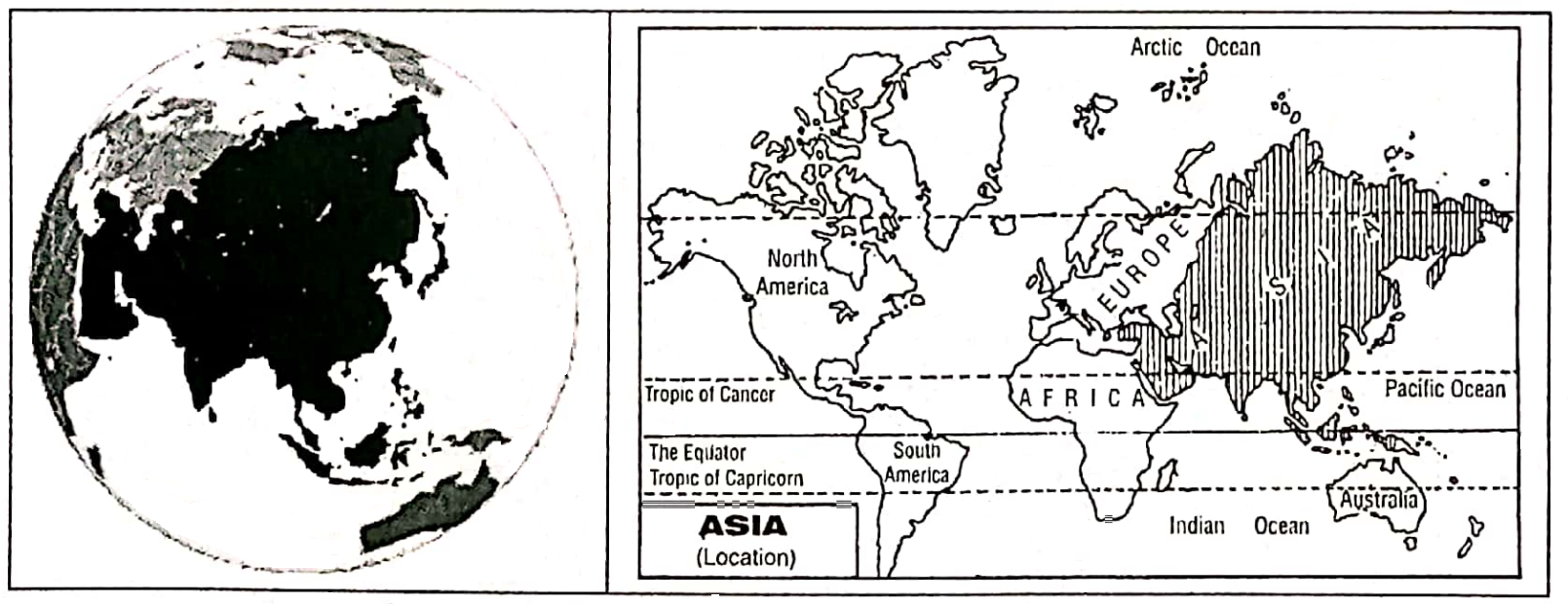
The continent of Asia mainly occupies the northern part of the Eastern Hemisphere.

In latitude, it extends from nearly 82° North to nearly 10° South and in longitude from 26°04′ East to 169°40′ West approximately, if the Cape Chelyuskin Island and Severnaya in the Arctic Ocean and the South-East Malaysian-Indonesian Archipelago are included.

” class 7th geography chapter 9 life in the desert”

It extends over a latitudinal range of 92° from North to South and a longitudinal range of about 165°.


WBBSE Solution For Class 7 Geography Chapter 9 Continent Of Asia Asia Location


Chapter 9 Continent Of Asia Boundary

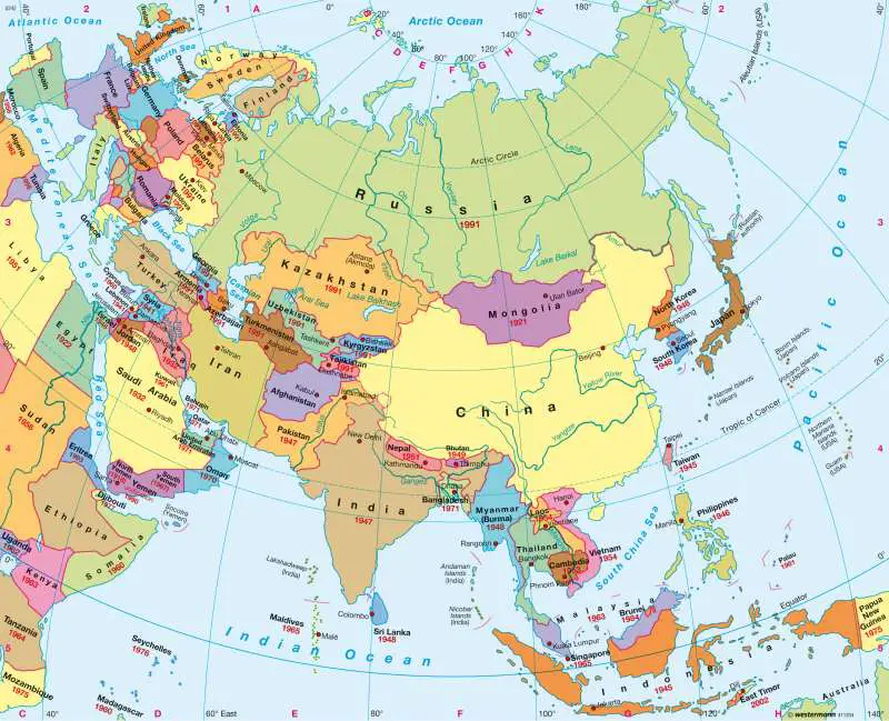
The continent is bounded on the north by the Arctic Ocean, and on the east by the Pacific Ocean and its associated seas. On the west Asia and Europe form a continuous landmass and the boundary between them is rather difficult to define.

It is marked by approximately the crest of the Ural Mountains, the Ural River, the Caspian Sea and the Caucasus Mountains.

Then it continues southward. the Black Sea, the Sea of Marmara, and the Aegean Sea. The country of Turkey lies partly in Europe (7%) and (93%) in Asia, on both sides of the narrow Straits-the Bosphorus and Dardanelles.

One-third of Russia (CIS) lies in Europe and the rest in Asia. Along the coast of Asia Minor (Turkey) with the Mediterranean Coast of the Levant forming Asia’s Western limits.

In the South of Asia lies the Indian Ocean and the associated Seas. Asia was connected with the continents of Africa by the Isthmus of Suez separating the Red Sea from the Mediterranean Sea.

class 7th geography chapter 9 notes

In 1869, a Canal, known as the ‘Suez Canal’ was cut through this isthmus; this joined the Mediterranean to the Red Sea and separated Asia from Africa.

In the northeast corner lies the Bering Strait between Asia and North America. Except New Guinea and the Aru Islands which belong to Oceania, the island of east India is considered as part of Asia.

WBBSE Notes For Class 7 Geography Chapter 9 Continent Of Asia

Area:

The total area covered by Asia is about 44579000 sq. km. This is almost one-third of the total landmass of the world. It is one-seventh larger than the two Americas together, twice as big as Africa and four times the size of Europe.

WBBSE Solution For Class 7 Geography Chapter 9 Continent Of Asia Asia Political


Extension:

The maximum length is 10780 km and the greatest width is 8530 km. The mainland of Asia is so compact that a considerable area in the central part of the continent is more than 2400 km away from the nearest Sea Coast.

Population:

Asia is the most populated continent in the world. These are nearly 417 crores of people (4164252000) (July 2011). 60% of the total population of the world lives here.


Chapter 9 Continent Of Asia Geographical Importance Of Asia

Asia is a typical continent exhibiting different types of natural and socio-cultural features. Some major features are described below:

  1. The largest continent of the world Asia is a vast continent with an area of about one-third of the earth’s surface.
  2. Asia has been the cradle of many ancient (around 3500 5000 B.C.) civilizations such as Mesopotamian, Indus valley and the Chinese. Civilizations associated with its ancient River Valleys. These civilizations flourished on the banks of the river such as Tigris, Euphrates, Indus, Hwang-Ho and Yangtze-Kiang.
  3. Asia and Europe though two continents are in fact one homogeneous landmass. A part of this undivided greater landmass is called ‘Eurasia’.
  4. The continent is so vast, that when the sun rises in the west, then the sun almost sets in the extreme east.
  5. This continent is different from others in respect of the nation, religion, caste, art and culture, human race and different things.
  6. World’s first civilizations, city-states, Kingdoms, empires and isolated village hamlets developed on this continent.
  7. All the world’s greatest religions began in Asia. These include Hinduism, Judaism, Christianity, Islam, Buddhism, Confucianism, Shinto and Zoroastrianism.
  8. The variety of landforms is infinite on the continent.
  9. The assembly of significantly high peaks is not found in any other part of the world.
  10. Asia contains a large number of rivers. Of the world’s ten longest rivers six are in Asia.
  11. There is an extreme variety of climates in different parts of the continent.
  12. All types of natural vegetation grow in Asia.
  13. Asia has two of the world’s most populous countries – China and India and most of the people (60%) of the world live in Asia.
  14. The greatest diversity in race, religion and culture and political systems of Government is to be found in Asia.
  15. Different types of power resources are found in Asia.
  16. This continent is rich in many types of mineral resources, such as coal, iron ore, bauxite, mica, petroleum etc.

Asia is also developed in agriculture and industries. The linguistic, ethnic and economic diversity of Asia is greater than that of any other continent.

” life in the temperate grasslands class 7 pdf “

Chapter 9 Continent Of Asia Continent Of Extremes

Asia is known as the ‘Continent of Extremes’ because there are some specific extreme characteristics found in Asia.
Asia is the largest continent in the world. It is also the most populated continent in the world. The highest mountain (in the Himalayas), highest mountain peak (Mt. Everest 8848 m),.

highest plateaus (The Pamir, ‘Roof of the world’), the largest high plateau Tibet, the largest lake in the world (Caspian Sea), the deepest lake in the world (Baikal), the lowest point of the land surface (Elghar valley of the Dead sea which is 393 m), coldest place (Verkhoyansk,- 56°C).

The Omiyakon in Siberia – 72° C, one of the hottest places in the world (Jacobabad; 52°C), the rainiest Cherapunji area (Mowsynram, 1254 cm), the largest peninsula in the world (Arabian Peninsula, 3250000 sq. Km) and the largest strait in the world (Malacca), the largest continental shelf (the Sunda platform), the deepest trench Mindanao Deep (Mariana trench – 11034 m)-all are situated in Asia. Such extremes make the continent of Asia the ‘Continent of Extremes’.


Continent Of Contrast

Asia, because of its size. location, extent and relief are characterised by contrasts in its climate, natural vegetation and other geographical features, Asia has rightly been called the ‘Continent of Contrasts’.

  1. Asia has the highest mountain peak in the world (Mt. Everest, 8848 m.) and the lowest part of the earth’s land surface (the Elghar valley of the Dead Sea – 393 m.)
  2. The deepest lake Baikal and the deepest trench Mariana are also situated here. It has the lowest record of temperature on the earth’s surface of Verkhoyansk (- 56°C) in     North-East Siberia. In contrast, Jacobabad in the Desert of Pakistan is one of the hottest places in the world (52°C).
  3. Asia has the highest annual rainfall in the world at Mowsynram on Cherapunji, Meghalaya, 1254 cm. (approximately), while most of the tropical and mid-latitude deserts, which are rather extensive, get less than 25 cm.
  4. It has practically every type of climatic belt and is consequent by natural vegetation varies from mass and lichen of the Tundra to the dense tropical/equatorial rain forest or coniferous forest of Taiga.
  5. Population density is not equal in all areas of the continent of Asia. High population density areas (fertile valleys) present a sharp contrast with vast sparse or   uninhabited areas (Déserts etc.)
  6. On the one side of this continent fertile river valleys are available on the other side there are barren lands in the central and western parts of the continent.
  7. Russia, which has a large extent in Asia, is the world’s largest country, while Maldives, Bahrain and Singapore are small countries having an area of less than 1000     km. each.
  8. Japan, S.Korea, Singapore, Taiwan etc. produce electronic and high-tech goods like computers, cameras and hi-fi equipment. Traditional industries and methods of working are still important to less industrialized nations e.g. India, Bangladesh, Vietnam etc.
  9. The political, religious, linguistic, ethnic and economic density of Asia is greater than that of any other continent.
  10. Asian living standards differ greatly. The industrial wealth of Japan and the oil wealth of the Gulf states of S.W. Asia contrast sharply with some of the poorest of this continent.

All the above factors clearly establish Asia as the ‘Continent of Contrasts’.

“class 7 geography ch 9 notes “

Chapter 9 Continent Of Asia Physiographical Or Topographical Features Of Asia

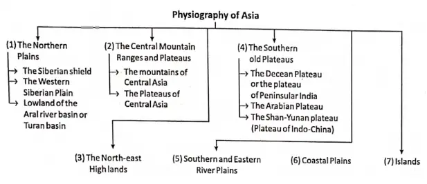
Asia is a vast continent which represents all the major landforms. On the basis of physiography, Asia is divided into seven divisions. They are as follows:

  1. The Great Lowland Triangle Of The North-west Or The Northern Plains,
  2. The Central Mountain Ranges And High Plateaus,
  3. The North-East Highlands,
  4. The Southern Old Plateaus,
  5. Southern And Eastern River Plains,
  6. Coastal Plains And
  7. Islands.


WBBSE Solution For Class 7 Geography Chapter 9 Continent Of Asia physiography of Asia


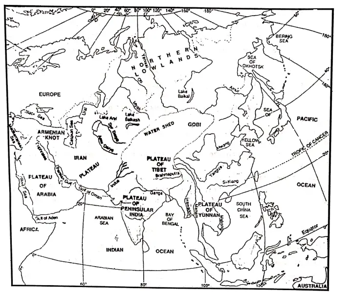
The Great Lowland Triangle Of The North-West Or The Northern Plains

The Northern part of the continent of Asia has a triangular-shaped plain of extensive flat land which occupies almost 40% of the continent.

It stretches from the Ural Mountain and the Caspian Sea in the west and southwest to the Yablonoy, Stanovoy and Verkhoyansk Mountains in the northeast. This northern plain of Asia is the largest plain in the world.


WBBSE Solution For Class 7 Geography Chapter 9 Continent Of Asia physiography


This extensive region can be further divided into three parts. They are-

  1. Siberian Shield,
  2. The Western Siberian Plain And
  3. Lowlands Of The Ural River Or Turan Basin.

Siberian Shield:

The Siberian shield stretches from the Bering strait in the east to the banks of the Yenisey river in the west. It is a very ancient and denuded surface which is formed due to the gradual erosion of old plateaus.

The Western Siberian Plain:

It stretches from the valley of the Yenisey river in the east to the western boundary of Asia in the west. The average height of the plain is 200 m. In this region between the Ob and the Yenisey rivers lies an extensive marshy lowland.

Lowlands Of Turan Basin:

The lowlands in the Southwestern parts of the northern plains, an area of inland drainage, the Amu Darya and the Syr Darya. Both of them flow to the Aral Sea, and other to the Caspian Sea.


The Central Mountain Ranges And Plateaus

At the continent’s heart or nearly the centre of Asia lies a convergence of the world’s mightiest mountains, like the Himalayas, Karakoram, Hindu Kush, Kunlun etc. So, Asia is also called the ‘Mountain hearted continent’.

In between the mountains be some famous plateaus. Most of the mountains extend from two centres or knots called

  1. Pamir Knot And
  2. Armenian Knot.

Pamir Knot:

The vast mountain system of Asia meets at the Pamir knot. To the north of Jammu and Kashmir state of India lies the world’s highest plateau-the Pamir

Nearly 4800 m high the Pamir is also called the ‘Roof of the world’ because it comprises a great mass of mountains with lofty plateaus (3600 – 4200 m).


WBBSE Solution For Class 7 Geography Chapter 9 Continent Of Asia the pamir knot and the Armenian knot radiating fold belts


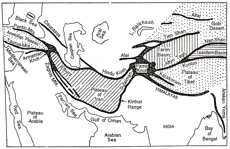
As the roof is the highest flat surface of a building so also the highest flat surface or plateau. on the Earth is the Pamir and hence is so-called. Most of the main mountain ranges of Asia. radiates long distances from the Pamir Plateau, so it is also called the ‘Pamir Knot’.

South-east of the Pamir extends the Himalayan Range. Himalaya is the largest and highest mountain in the world.

Mt. Everest is the highest peak in the Himalayas (8848 m) and also the >world. Further North of the Himalayas lies the Karakoram Mountain range. The highest peak of the Karakoram range is Godwin Austin or K2 (King of Karakoram).

It is the 2nd highest peak in the world (8611 m). East from the Pamir extends the Kunlun, Altyn Tagh, Nan-shan, Siniling- shan and Khingan Mountains.

Stretching northeast from the Pamir, extend the Tien-shan, Altai, Sayan, Yablonovoy and Stanovoy Mountain ranges. West of the Pamir extends the Hindu Kush mountain range and South-west of the Pamir knot extends the Sulaiman and Kirthar mountain ranges.

Further west it forms the Zagros mountain which merges with the Armenian Knot.

Armenian Knot:

This plateau or knot is located to the southeast of the Black Sea. To the east of this knot extend two mountains-Zagros and Elburz and to the North-west of this knot extend two Mountains-Pontic and Tauras.

Between these two ranges lies the Anatolia Plateau, called ‘Asia Minor’. The Caucasus range belongs to Europe.

The Central Asiatic Plateaus:

The vast plateaus lie between the folding mountains and the northern plains. The plateaus of outstanding importance are as follows.

The Plateau Of Tibet:

This is the largest plateau in the world and it is surrounded by great Himalayas to the south and Kunlun to the north.

The Plateaus Surrounding The Tarim Or Sikiang Basin:

The Tarim basin is one of the driest basins in the world. It is surrounded by Tien Shan to the north and Altyn Tagh to the south. This basin is largely occupied by the Takla Makan Desert.

The Tsaidan Basin:

This basin lies between Kunlun in the south and Nanshan in the north.

The Plateau Of Gobi Or Mongolia :

This plateau is a stony desert and lies between Altai and Nanshan ranges the average height varies from 1000 metres to 1500 metres above sea level.

Plateau Of Iran:

This plateau covers really whole of Iran. It is situated between Elburz and the Hindu Kush to the north and Zagros to the south.

Plateau Of Anatolia:

The plateau of Anatolia lies in the central part of Turkey. It is bounded by Pontic to the north and Tauras to the south.

The Sistan Plateau:

The Sistan Plateau of Afghanistan lies between the Hindu Kush Mountain in the north and the Sulaiman Mountain in the south.

The plateau of central Asia is surrounded by mountains so most of them are dry with little vegetation, i.e. nearly like deserts or actual deserts. This area is also called the “Dead Heart of Asia”.


The North-East Highlands

It is mainly a highland region including high ranges around the Verkhoyansk and Kolyma tablelands. The Mountains of Kamchatka and Sakhalin constitute comparatively young parts of the Pacific ocean mountain belt.

They have numerous extinct active volcanoes. The mountainous islands of Kuril Arc are an extension of the Kamchatka mountains.

The northeastern highland region can be traced even to the isolated ranges north of the Tien-Shan. There are the Yablonoi-Stanovai and the extensive Altai-Sayan mountain stand.

Along the southern shore of Lake Baikal lie the Sayan mountains. The ranges of the east are the Khingan mountains and the Shanshi highlands.


The Southern Old Plateaus

The old plateaus of South Asia can be divided into three sections-

  1. The Plateau of the Arabian Peninsula,
  2. The Deccan Plateau of Peninsula India and
  3. The Plateau of Indo-China or the Shan-Yunan plateau.

The Plateau Of Arabian Peninsula :

The Arabian Plateau is situated in South-west Asia. This plateau is not much broken up. Its steep edge lies on the west towards the Red Sea.

It slopes on the northeast towards the Tigris-Euphrates valleys. The whole region is dry and it is entirely a desert land without lakes and rivers.

The Deccan Plateau Of Peninsular India:

It is the oldest part of Asia and one of the most stable landmasses in the world. The whole terrain is made up of several large or small plateaus forming into a dissected plateau.

The undulating surfaces with broad, rounded summits seldom rise above 600 m. constitute important physiographic uniqueness of the area.

The-Shan-Yunan Plateau Or The Plateau Of Indo-China:

It includes parts of the Shan state of Myanmar and the Yunan state of China. Towards the south, it extends up to the Malayan peninsula. It is, a dissected plateau broken by the rivers like Salween, Mekong and Upper Yangtze.


Southern and Eastern Alluvial River Plains

The great lowlands of Eastern Asia and Southern Asia are mainly the river plains or the alluvial plains. These plains are fertile and the most densely populated areas. Some of the most important river valleys are as follows:

  1. The Indo-Gangetic plain of India,
  2. The Tigris-Euphrates valley plain of Iraq,
  3. The Irrawaddy Basin of Myanmar,
  4. Menam valley of Thailand and
  5. Mekong valley of Cambodia and Vietnam,
  6. The Hwang-Ho, Yangtze-Kiang and Si-Kiang valleys of China and
  7. The Amur valley.


Coastal Plains

Asia is bounded by the Arctic Ocean to the north, the Pacific Ocean to the last and the Indian Ocean to the South and has numerous seas, bays and gulfs which are of strategic importance.

To the northeast and south, this continent has coastal plains that vary from being very broad in some places while at others it is narrow. Many places are fertile and cultivable but some parts are salty and sandy. So these plains are not suitable for cultivation.


Islands

Asia has a large number of islands. There are some isolated islands and some groups of islands in the Pacific Ocean in the east and south-east of Asia like-

  1. The Japanese Islands,
  2. The Philippine islands,
  3. The Indonesian islands,
  4. The Malaysian islands (Malay, Sarawak, Sabah, and Singapore).


Chapter 9 Continent Of Asia River Of Aisa

The continent of Asia contains a large number of rivers. Of the world’s ten longest rivers, six are in Asia. The characteristic features of the rivers or drainage system of Asia are as follows:

  1. Most of the rivers of Asia rise from the extensive mountain regions in central Asia.
  2. Many rivers also rise from the plateau of the south but they are comparatively smaller.
  3. These rivers are snow-fed and rain-fed. Some tidal rivers are found in the coastal areas.
  4. There are many perennial rivers and non-perennial rivers. Generally, snow-fed rivers are perennial and rain-fed rivers are non-perennial.
  5. These rivers flow in many directions according to the slope of the land, but as we will see this is not always the case with the Asian landscape. The Himalayan rivers actually cross the Himalayas in deep Gorges and flow at right angles to the cross-section.
  6. The rivers form a pattern of drainage network which is strongly influenced by geological structure.
  7. Most of the rivers of Asia either flow to any of the Arctic, Pacific and Indian oceans or internal depressions.
  8. The rivers of Japan are short and swift and are helpful for the production of hydro. electricity.
  9. The rivers give rise to fertile valleys.
  10. A number of river-based civilizations developed in the large river valleys of Asia. According to their direction of flow rivers of Asia may be grouped into the following categories:

Important Rivers Of Asia


Type of the Rivers Name of the Rivers
1. North-flowing Rivers Ob, Yenesei, Lena, Khatanga, Kolyma
2. East-flowing Rivers Amur, Hwang Ho, Yangtze-kiang, Si-kiang
3. South-flowing Rivers The Ganges, Brahmaputra, Indus, Mekong, Menam, Irrawaddy, Tigris, Euphrates
4. Inland Rivers Amu Darya, Syr Darya, Alli, Tarim, Ural, Luni, Helmond, Jordon
5. Wesfflowing Rivers Narmada, Tapi Narmada, Tapi


North Flowing River

Ob, Yenesei, Khatanga, Kolyma etc. are the main river falling into the Arctic Ocean. The characteristics of these rivers are as follows:

  1. These rivers rise from the mountains in central Asia and flow to the north.
  2. The mountains of these rivers are located in the Frizid zone. So, they are covered by ice for nearly 8 to 9 months in a year.
  3. Floods occur often in the middle and lower courses of these rivers.
  4. A number of marshlands are found in these river basins.
  5. The navigability of these rivers is poor. So, these rivers are not much used for navigation.
  6. These river basins are sparsely populated.


WBBSE Solution For Class 7 Geography Chapter 9 Continent Of Asia Rivers and Seas of Asia


Ob:

The mainstream of the Ob (3677 km long, with Irtish 5570 km long) rises in the Great Altai Mountains and flows to the north. The Irtish, its principal tributary, is longer than the mainstream before their confluence.

Ob along with Irtish is the 2nd longest river in Asia. The river flows very sluggishly over the flat West Siberian Plain and falls into the Arctic Ocean (the Gulf of Ob).

Yenesei:

Yenesei (5540 km) is coming out from the Sayan Mountains flows towards. north and falls into the Arctic Ocean (Yenesei Gulf). Its main tributary is the Tungaska. Yenesei is the 2nd longest river in Asia and the 5th longest river in the world.

Lena:

Lena (4270 km), rises from the mountains adjacent to Lake Baikal and flows to the north into the Arctic Ocean (Laptevic Sea). Vitim and Aldan are its two main tributaries.

Khatanga:

It is coming out from the Sredne Highland, flows north and falls into the Arctic Ocean. Kheta is its main tributary.

Kolyma:

It is coming out from Khrebet Cherakogo (Gida Mountains) high land flows north and falls into the Arctic Sea. Omoloki is its main tributary.


East Flowing Rivers

The Amur, Hwang-Ho, Yangtze-Kiang and Si-Kiang etc. are the main rivers of Asia that flow to the east and drain into the Pacific Ocean at different parts. The characteristics of these rivers are as follows:

  1. These rivers rise from the central Mountain area and Plateau region and flow into the Pacific ocean.
  2. These rivers are perennial and carry a large volume of water. These rivers have a long plateau course.
  3. Deep Gorges are found in the mountainous courses of these rivers.
  4. The Principal rivers have rapids in their plateau course. This impairs the navigation of the rivers.
  5. The rivers have formed depositional plains rich in the alluvium in their lower courses.
  6. These rivers are navigable and they play an important role in the transportation system.
  7. Most of the river basins are densely populated.

The Amur (4440 km):

The Amur coming out from the Yablonoy Mountains flows towards the east and falls into the Pacific Ocean (Okhtosk sea).

The Hwang-Ho (5460 km):

It rises from the north of the Bayanhar Mountains lie in the Ching-hi state of China and flows to the east and falls into the Pacific Ocean (the Bay of Po-hai). Large amounts of less are lifted from the Gobi desert of Mongolia and deposited in the Hwang-Ho river by the wind.

The loess is yellow in colour and when carried by the Hwang-Ho, the river looks yellow. Therefore the Hwang-Ho is also called the ‘Yellow River’. The river was known as the ‘Sorrow of China’ as it used to create floods each and every year.

But now it is not all known as the ‘Sorrow of China’. The river has been dumped in several places and thereby providing irrigation facilities to a vast region. Its main tributaries Phen-Ho and Wei.

The Yangtze-Kiang:

Yangtze-Kiang is the longest river 5590 km/6300 km in China. It is also the longest river in Asia as well as the third longest river in the world: Yangtze-Kiang means, the ‘son of the ocean’.

It is also known as the river of ‘Golden Dust’. It is coming from the Geladangdong mountain peak in the south of Kunlun mountain flows towards the east and falls into the Pacific Ocean (North China Sea).

The Si-Kiang (2340 km):

The Si-Kiang rises from the Umang mountain region of the Yunan plateau (Yunan Province of China). It flows towards the east and finally falls into the South China Sea. Peikiang is its main tributary.

The lower course of this river is known as the Canton river as the 2nd largest city and port in China, Canton is situated on the bank of the river. The river is also known as the ‘Pearl river’ in China.


South-Flowing Rivers

The Ganges, Brahmaputra, Indus, Mekong, Menam, and Irrawaddy. Tigris, Euphrates etc. are famous rivers. The characteristics of these rivers are as follows:

  1. Most of the rivers, except the Tigris and Euphrates, originate in the Mountains and flow through the monsoon climatic region.
  2. These rivers are fed by both snow/ice melt water and rainwater.
  3. These rivers’ valleys are very fertile.
  4. These rivers are navigable and suitable for irrigational purposes.
  5. In the lower course of the rivers flooding occurs in the rainy season.
  6. Most of these river valleys have a dense population.

The Ganges (2510 km):

The Ganges is the longest river in India. It rises from the Gangotri Glacier of the Himalayas. It is the confluence of two river-Alakananda and Bhagirathi. The combined river cuts through the Himalayan Ranges and debouches to the plain near Hardwar.

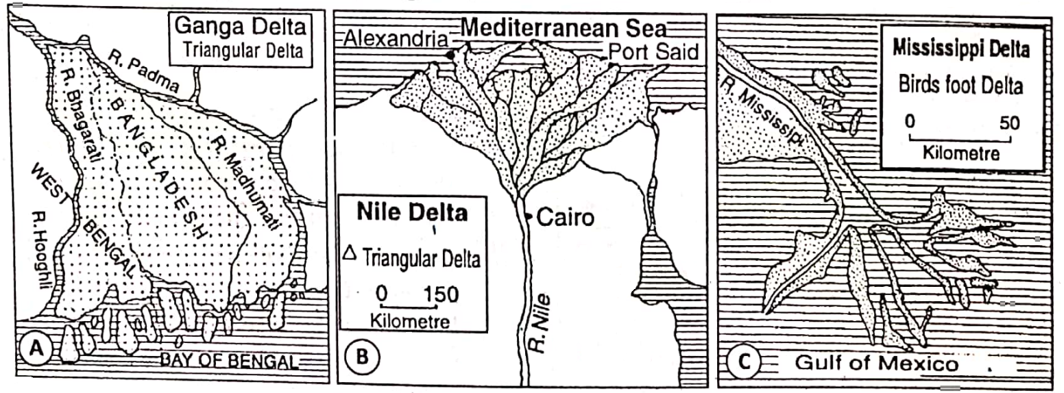
It then flows southeast through the north Indian plain and finally divides into two branches near Rajmahal hill. The main eastern branch (the Padma) enters Bangladesh and the slender western branch (the Bhagirathi) flows through West Bengal and falls into the Bay of Bengal near Sagar Island.

The main tributary of the Ganges is Yamuna. The Ganges- Brahmaputra Delta is the largest delta in the world.

Brahmputra (2580 km):

It rises from the Chemaung-dung glacier of the Tibetan plateau. flows towards the cast. Around Namcha Barwa the river turns southwards, enters India and then turns westwards.

To the west of the Meghalaya plateau, it again turns southwards to meet the Ganges near its mouth before entering the Bay of Bengal. Majuli Island in the River Brahmaputra is the largest river island in the world.

The Indus (2880 km):

It rises near Manas Sarovar lake in Tibet and then flows to the northwest and around Nanga Parbat, it turns to the southwest to finally drain into the Arabian Sea. Its main tributaries are Jhelum, Chenab, Ravi, Sutlej, Beas etc.

Mekong (4350 km):

It is the main river of Indo-China. It rises from the southern slopes of the Kunlun mountains and flows along the eastern boundary of Thailand before draining into the South China Sea.

Menam (365 km):

The river rises from the Shan plateau of Myanmar and flows to the south into the Gulf of Siam.

Irrawaddy (2090 km):

The river rises from the northern highland of Myanmar flows towards the south and falls into the gulf of Martaban. It is the main river of Myanmar. The main tributary of this river is Chindwin.

Tigrese (900 km) And Euphrates (2780 km):

These two rivers are rising from the Armenian plateau, and flow south through Iran and Iraq. The joint flow of these two rivers is known as ‘Sat-el Arab’ and then flows into the Gulf of Persia.


Inland Rivers

There are some inland rivers in Asia. Among these rivers Amu Darya, Syr Darya, Illi, Tarim, Ural, Jordon, Helmond, and Luni are mentionable. The characteristics of these rivers are as follows:

  1. The rivers do not drain into seas and oceans.
  2. They end their journey in inland water bodies such as the Caspian sea (Lake) and Aral Lake.
  3. Northwest in Central Highland of Asia lies in the huge area of inland drainage.
  4. These rivers do not hold much water due to scanty rainfall in their catchment areas.

Amu Darya ind Syr Darya :

These two rivers are coming out from the Pamir plateau flow towards the northwest and fall into the Aral Sea.

IIIi:

It is rising in the Tien Shan Mountain region flows north and falls into the Balkhas Lake.

Tarím 1600 km:

The Tarim river is the world’s largest inland river. It rises from Karakoram Mountain and falls into Lop Nor Lake. This river has formed the Tarim basin. It is a non-perennial river.

The Ural:

It rises in the Ural mountains flows towards the south and falls into the Caspian Sea. The Helmond: The Helmond river rises in the Hazaragat Highland in Afghanistan flows towards the west and falls into the Hanun-I-Helmond Lake.

The Jordon:

Jordon is a small river. It rises from the Lebanon Highland flows through Jordon Valley and falls into the Dead Sea. This river remains dry throughout the year because of Scanty rainfall.

Luni :

This river is coming out from the Ana Sagar Lake of Aravalli Mt. flows towards the southwest and falls into the Rann of Kutch.


West-Flowing Rivers

There are few major west-flowing rivers in Asia. Among them the Narmada and the Tapti (Tapi) are noteworthy.

Lakes Of Asia:

There are numerous lakes and marshes in Asia. Among them, some lakes have fresh water that is drinkable while others have salt water.

Freshwater Lakes In Asia:

The largest freshwater lake in Asia is Lake Baikal (Baykol) in Russia. It is the world’s deepest lake (1637 m below sea level). The other freshwater lakes are Manas Sarovar in Tibet, Dal and Wuler lake in Jammu and Kashmir, Nainital, in India, and  Beuya Lake in Japan.

Saltwater Lakes In Asia:

The Caspian Sea (The largest lake in the world), Aral Sea, Balkhas, Dead Sea, Lop Nor (China), the Van lake of Turkey etc.


Chapter 9 Continent Of Asia Climate Of Asia

The climate is a very important element of the natural environment. The continent of Asia is so large that almost all the climatic types of the world are found here.

Causes or Factors of Diversity of the Climate in Asia: Enormous size, shape, compactness, range of latitude, latitude and alignment of mountains, direction of winds, and ocean currents combine to produce great climatic contrasts in Asia.

Factors affecting the climate of Asia are as follows:

  1. Latitudinal factors,
  2. Altitudinal factors,
  3. Continental factors,
  4. Influence of wind,
  5. Ocean current,
  6. Presence of Topography or Mountains,
  7. Distance from the Sea.

1. Latitudinal Factor:

The continent of Asia lies between 82°N and 10°S latitude. The latitudinal range is 92°.

So the northern part of this continent is in the Arctic or north polar region (Frizid zone), the central part is in the Northern temperate zone and the southern part (Equatorial region) is in the torrid zone. Sun’s rays are oblique as we move away from the Equator.

As a result of average annual temperature gradually decreases from the Equator towards the Poles.

2. Altitudinal Factor:

Temperature decreases at a rate of 6.4°C with every 1000 m or 1 km rise in altitude. The average altitude of the Central Highlands of Asia is more than 4000 m High. So there is a difference in temperature in the lofty peak region and base region of a mountain.

3. Continental Location Or Distance From The Sea/Ocean:

One-third of this continent is nearly 1000 km from the sea and some part is near about 2400 km from the nearest sea coast.

The moderating influence of the sea does not reach the interior of the continent, so extensive areas in the central region have extreme climates.

4. Topogrophy/Presence Of Mountains And Plateau:

High mountains of this continent remain covered with snow and the intermontane plateau experienced extreme climate

For example, the great Himalayan Mountains act as a barrier to the influx of cold north wind to South Asia and the warm, rain-bearing south or south-west winds to the heart of Asia.

5. Direction Of wind:

Directions of winds are particularly important in Asia. In summer moist monsoon winds from the south come from the Indian Ocean and give plenty of rainfall to the southern region of Asia.

In winter the monsoon winds outflowing from land to sea are dry and cause Asia to be rather rainless.

6. Ocean Current:

According to the high latitudes that cross the northeastern coast of Asia, the region should have a cold climate.

But the warm ‘Kuroshio’ ocean currents flow along the shores of the area, so this part of Asia has a temperate climate occurring over the region.


Chapter 9 Continent Of Asia Characteristics Of Asian Climate

  1. The continent of Asia is stretching from the north. The northern part of this continent is in the north polar region, the central part is in the northern temperate zone and the southern part is in the torrid zones.
  2. One-third of this continent is nearly 1000 km away from the sea and some part is near about 2400 km away from the sea. This region is experienced extreme climate.
  3. High mountains and their lofty peaks this continent remain covered with snow and the intermontane plateaus experienced extreme climate.
  4. The southern and central parts of this continent have huge mountains. So there is a difference in temperature and rainfall here.
  5. The coastal region of this continent is influenced by ocean currents.
  6. The influence of two monsoon winds (North-East and South-West) is particularly important in Asia.
  7. The presence of forests also influences the climate of Asia.
  8. One of the hottest and the coldest part of the world are situated here Jacobabad (Pakistan) is one of the hottest places and Verkhoyansk (Russia) is one of the coldest parts of the world.


Chapter 9 Continent Of Asia Seasonal Conditions Of The Important Elements Of Climate In Different Parts Of Asia

Temperature:

In summer temperatures are very high from Arabia in the west to the northwest of India in the east. Temperatures vary from 32°C-38°C in the region in July.

The average temperature in the summer season in the un limit of Asia is 7°C on average. The southern part of Asia has the highest temperature in winter.

In January the temperature varies between 20° to 27°C. Further north temperature decrease In Siberia and far east at many places temperature fall below freezing point in January -30° to 40°C.

Air Pressure And Winds:

Extremely high temperature in summer in the tropical region, especially in northwest India creates a severe low-pressure belt over the region.

During the same season, there is high pressure over the India ocean, so winds carry plenty of water vapour from above the ocean and move into the low pressure over the northwest of India.

During winter the extreme cold in central and northern Asia causes high pressure over the region. Cold and dry winds then move from this high pressure in central and northern Asia to move to the low pressure in the south and east.

Rainfall:

During summer the monsoon winds blowing from the Indian and pacific ocean towards the mountain region of central Asia are moist and causes abundant rainfall in Southeast Asia (including India and China).

Rainfall is over 100 cm on average. The highest annual rainfall. in the world occurs in India in the state of Meghalaya at Mowsynram near Cherapunji.

It is nearly 1250 cm. Central Asia is surrounded by mountains, and the plateaus in the centre receive the least rainfall, 25 cm on average.


WBBSE Solution For Class 7 Geography Chapter 9 Continent Of Asia Summer and Winter Rainfalls


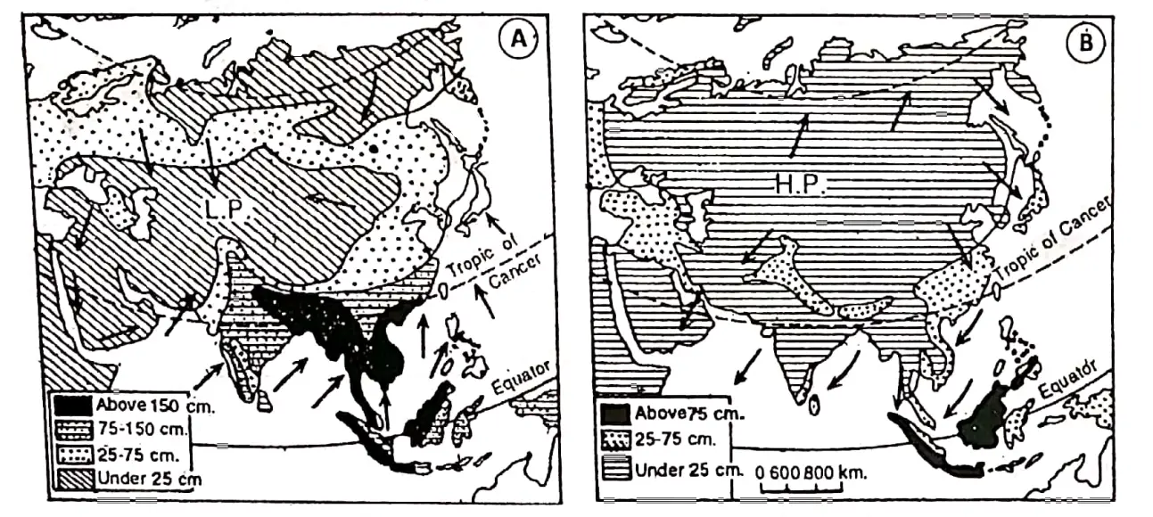
In winter the winds blow from land to sea. These winds are dry since they blow from the land. So most of Asia receives very little rain in the cold season except the west.

Being situated in the equatorial region temperature and rainfall over the East Indies (Malaysia and Indonesia) remain uniformly high throughout the year.

Some rain occurs along the Mediterranean coast and the influence of westerly winds. In Japan, the southeast coast of India northwest India etc. receives some rain.


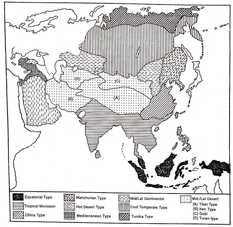
Chapter 9 Continent Of Asia Climatic Regions Of Asia


WBBSE Solution For Class 7 Geography Chapter 9 Continent Of Asia Climate Region of Asia


Climatic Type/Region Location Characteristics 
1.Equatorial climate. The Equatorial type of climate is located between 5° S to 5° N parallels of latitude. It is observed in different countries of Asia such as Maldives, Sri Lanka, Singapore, Indonesia etc. 1. Hot and Humid climate, 2. High-temperature throughout the year as the Sun’s rays fall vertically. 3. Very low-temperature range between  2 and 3° C. 4. Average annual temperature is in between 25° to 30° C. 5. Conventional type of rainfall occurs every afternoon throughout the year. Annual rainfall is 200 to 250 cm. 6. On account of marine location temper  nature remains uniform deviating little from 27° C and is well distributed
2. Tropical Monsoon climate. This type of climatic region covers India, Bangladesh, Pakistan, and Myanmar. Laos Cambodia, Vietnam, Southern China and Japan. 1. This type of climate is greatly influenced by 2-monsoon winds.  2. An important characteristic of this climate is the cycle of seasons. 3. Summers are hot and humid while winters are mild and dry. 4. Summer temperatures vary between 30°C – 32° C while in winter they are 18°C- 22°C.  5. Annual rainfall varies from 100 to 200 cm.
3. Warm temperature or Type of climate. This type of climate is found in the north and central parts of China and in some parts of South Korea and Japan. Warm temperate or China type of climate. 1. Summers are mild with an average temperature being 27° C. 2. Winters are quite cold with temperatures between 4°C to 12° C. 3. Snowfall occurs in some places. 4. Summers are moist and winters are dry. 5. Annual rainfall on average is about 100cm occurs in summer due to Monsoon. 6. In summer typhoons or severe cyclones cause rainfall.
4. Manchurian type of climate.  It extends over Manchuria to North and South Korea, Sakhalin. the island of Russia and the northern part 1. Milder summers and more severe winters than China’s type of climate.  2. Moderate rainfall occurs in summer.  3. Sufficient snowfall occurs In winter.
5. Hot Desert type of climate The Tropical hot deserts type of climate is found in Saudi Arabia. Iran. Iraq. Pakistan. India (Thar) etc. 1. The summers are dry and hot. 2. Sometimes temperature rises 48° to 5o°c. 3. Range of temperature is very high. 4. Rainfall is very scanty and less than 25 cm.
6. Mid-Latitude Desert type of climate. In Asia, this type of climate is further divided into the following groups: 1. Tibet type. 2. Iran type. 3.Gobi type 4.Turan type 1. Tibet’s type of climate is found on the plateau of Tibet, 2. Iran’s type of climate is found in the enclosed of Iran. 3. Gobi-type climate is found in the Gobi desert and desert area of Tibetan Highlands. 4. Turan-type climate is found mainly in southwest Siberian lowlands around the Aral Sea and Afghanistan. 1. Summers and hot and dry, Temperature often reaches up to 37° C. 2. Winters are cold. 3. The annual and diurnal ranges of temperature are high. 4. The rainfall is very scanty. So mid-latitude deserts are found in continental interiors. 5. The rainfall occurs mainly in early summer and spring. 6. Amount of rainfall is about 30 cm
7. Mediterranean type of climate. This type of climate is found In Turkey, Syria, Lebanon Jordon, Israel, and parts of Iran and Iraq. 1. The main characteristics of this climate are dry summer and wet winter. 2. Cyclonic rainfall ISO cm to 100 cm) are common. 3. Temperature varies from 20°C to 28°C. The range of temperature is not high. Day temperature sometimes exceeds 32°C. The temperature drops sharply at night because of the clear sky. 4. The long summer days have clear blue skies.
8. Continental type of climate. This region comprises steppes and west Manchurian type of climatic regions. It includes all the plateaus of central Asia surrounded by mountains {the Anatolian plateau in the west, the Kirghiz arc in the middle and the Gobi desert in the east. 1. Short duration of summer and long duration of winter are the main characteristics of this climate.  2. The annual and diurnal range of temperature is very high.  3. Some rainfall occurs in summer and snowfall occurs in winter. 4. The amount of rainfall ranges from 25 to 75 cm.
9. Cold-Temperate or the Taiga type of climate. This type of climate is found between Tundra to the north and Steppe to the south in a narrow belt, also known as a Siberian type of climatic region. 1. In this region winters are very severe and prolonged particularly in Siberia where the temperature is below the freezing point. 2. Summers are pleasantly warm and the average temperature is about 18°C. It rises occasionally up to 35°C and 40°C. 3. This causes a very high range of temperature. 4. The rainfall is scanty, between 30 cm to 60 cm. 5. Winters face heavy snowfall and frozen lakes and rivers. 6. On the whole winters are long and cold and summers are short and warm.
lO.Tundra type of climate. In the northern border of Asia,  north of the Arctic circle (66½° North) this climate occurs. The region lies in Russia. 1. Winters are long and very severe with a long duration of darkness while the summers are brief and cool (O°- 10°C). 2. Then winters bring Icy cold winds (blizzards) and so it is very cold. 3. Annual rainfall, though a major amount in the form of snow is about 25 – 30 cm.
11. Mountainous type of climate. This type of climate is found in the central highlands of Asia. 1. Temperature decreases with increasing altitude. 2. Rainfall is higher on the windward side than on the leeward side. 3. The high altitudinal regions’ temperatures are lower than the low altitudinal region.


Chapter 9 Continent Of Asia Natural Vegetation Of Asia

Natural Vegetation:

Plants that grow naturally in nature, without any human help, are called natural vegetation. This natural vegetation can form forests or jungles.

Natural vegetation is closely related to climate. Variations in temperature and rainfall cause variations in the growth of plants.

Asia being a large continent great variation in climate causes variations in the distribution and type of natural vegetation. Almost all types of natural vegetation grow in Asia. The natural vegetation of Asia can be classified into the following Natural Vegetation Belts of Asia.

1. Equatorial Evergreen Rain-Forests:

These dense evergreen forests are in the equatorial region due to high temperatures and rainfall. In Asia, these forests are found in Indonesia, Malaysia, Sri Lanka, etc.

Luxuriant forests of multiple species of very tall trees (about 45 meters) struggle towards the sunlight forming a thick canopy arrangement. They yield tropical hardwoods.

The principal trees are Mehogony, Rosewood, Ironwood, Teak, Ablus, Rubber, Cocoa, Cinchona etc. There is a thick undergrowth of numerous epiphytes.

At the ground level saprophytes are found in numerous varieties. This thick growth makes the commercial exploitation of the forests very difficult.

2. Tropical Monsoon Forests:

This is a typical forest, found in regions of monsoon climate. Due to humid summers and dry winters, both green and deciduous trees grow in this region. These forests are found in northern Malaysia, Thailand, Kampuchea, Vietnam, Laus, India, Pakistan, Bangladesh, Myanmar and South China.

In the areas having more than 200 cm rainfall evergreen forests are found, and the lands which get rainfall between 120-200 cm have deciduous monsoon forests. The principal trees are Mango, Mahogany, Ablus, Sal, Teak, Bamboo, Banyan, Peepul etc.

On mountains are found mixed types of deciduous vegetation and on coastal lands mangrove trees.

3. Sub-Tropical Mixed Forests:

These are so-called because of the admixture of deciduous trees with the majority of evergreen trees. One important aspect of these forests is that they marge into grasslands, both tropical and temperate and form parts of the ‘Pask land’ aspect of the grassland borders.

The evergreen trees decrease in number as one advance from coastal lands into interior parts. The deciduous trees occur equatorward and evergreen poleward. These forests are mainly found in northern Myanmar, southern and central China and in southern Japan.

The trees range from bamboo, palm, laurel, and beech as deciduous varieties. Important evergreens include chestnut, oak, camelia, and magnolia.


WBBSE Solution For Class 7 Geography Chapter 9 Continent Of Asia Natural Vegetation of Asia


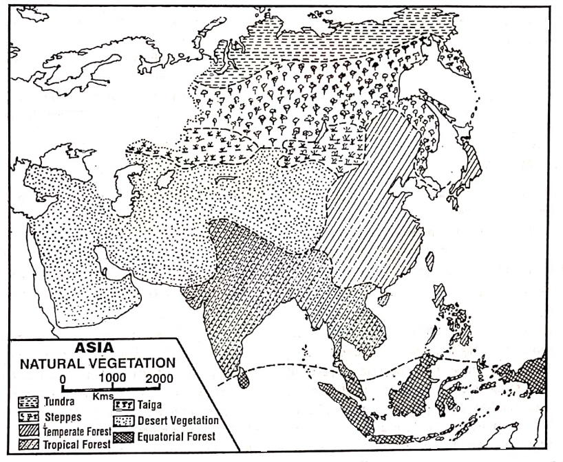
4. Temperate Mixed Forests:

These forests have two main characteristics. Firstly, the trees, are of mixed variety-deciduous and coniferous. Deciduous trees like oak, ash, alder, chestnut, and beech are a response to a temperate moist climate.

Theconferious trees like spruce, larch, silver fur and red pine are adapted to mountain regions like Hanshu Island of Japan. These mixed forests occur in North China, Manchuria, Central and northern Japan and in the adjoining areas.

5. Mediterranean Forests:

These forests are found along the Mediterranean coastal lands mainly in Israel, Syria, Lebanon and Turkey. Most plants like vines and chestnuts have long roots and others like citrus fruits trees have waxy leaves; others like olive small leave.

A number of citrus fruit-bearing trees such as Olive, Grapes, Lemon, etc. and other trees such as Cork-Oak, and some bushes such as Laurel, Lavender, Rosemary etc. grow here.

6. Steppe Grasslands:

In the mid-latitudes in the interior of the continent extending from the west to Manchuria in the east covering southwest Siberia, fringes of the Mongolian plateau and lowlands of Manchuria are extensive areas of grasslands known as ‘Asian Steppes’.

The steppes of central Asia are very dry and they get scanty rainfall ranging between 30 – 50 cm received mainly in summer. Most people lead a nomadic mode of life.

They are found in the Kirghiz steppe and Manchurian lowlands. Northward these grasslands form a ‘parkland’ with coniferous forests and southward they border the desert areas.

7. The Cool Temperate Or Evergreen Coniferous Forests Of Taiga :

These forests are found in high latitudes and mountain slopes. Their climate is characterised by cool Temperate Continental (Siberian) Climate and they are located South of the Tundra region. In Asia, these forests cover the areas of northern Russia including Siberia and Sakhalin.

The evergreen coniferous forests are of moderate density with little undergrowth and are in pure stands (a single type of forest). The trees are conical in shape to prevent the accumulation of snow on the branches and have small, thick, leathery needle-shaped leaves to check excessive transpiration.

Pine, fir, spruce, larch, hemlock, and cedar are common trees. The Taiga forest of Russia is the largest coniferous forest in the world.

8. Desert Vegetation :

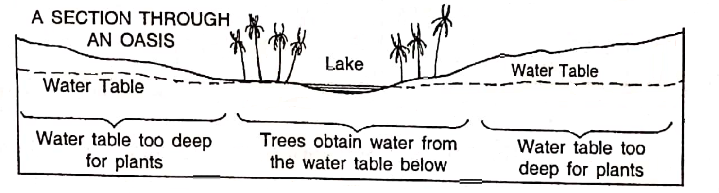
The hot deserts in South-west Asia are also not without vegetation. There are of course spiky grass, dwarf bushes, and prickly plants. The vegetating corner of the continuous type is mostly found near or around the oasis.

Tall trees like dates and palms may also be found there. The clumps of leafless thorny perennials and others with stunted growth resist evapo transpiration. Cacti and in fact all the thorny bushes are among such plants grown in the desert.

9. Tundra Vegetation:

The Tundra Vegetation belt extends in a narrow belt north of the Arctic circle and along the northern shores of Asia. Winters are long (8-9 months) and very severe. So the Tundra is a result of excessively cold, strong winds and permanently frozen subsoil.

During the summer of 2-3 months willows and dwarf shrubs exist in favoured brutalities. The south-facing slopes exhibit in summer a short-lived splendour of flowering herbaceous plants. Moss, lichen, algae, sedges and bright Arctic flowers brighten the landscape.


Chapter 9 Continent Of Asia Yangtze-Kiang Basin Of China

The Yangtze-Kiang basin of China is drained by the river Yangtze-Kiang and its tributaries. Yangtze-Kiang is the third longest river in the world, after the Nile and Amazon rivers. The Yangtze- Kiang is the longest river in China as well as the continent of Asia.

The river originates from a glacier lying southwest of the Geladandong peak of the Tanggula Mountain in Qinghai province and flows eastwards to meet the East China Sea.

From the source to the mouth, the river extends for nearly 6300 km, covering a basin with an area of 1807199 square kilometres. Near the mouth, the river has formed a huge delta.

Importance of Yangtze-kiang Basin:

Yangtze-Kiang is not only the longest river in China but also the most important of all rivers. The river plays an important part in the economy of the country. The river basin is a fertile and multi-cropping zone. A large number of food and cash crops are raised.

The basin is one of the largest producers of rice. In China, 70% of the rice production occurs in this region and nearly 50% of all other food grains are produced here. So this river basin is called the “Granary of China” or the “Rice bowl of China”.

Sericulture is an important occupation of the people of this region. A large proportion of the mineral wealth and industrial products are also produced in this region.


A Geographical Divisions Of Yangtze-Kiang Basin

Due to differences in relief, soil and climate, the Yangtze-Kiang basin is divided into three sub-divisions-

  1. The upper course or Szechuan Basin or Red Basin,
  2. The central or Middle course of the Yangtze-Kiang Basin and
  3. The Deltaic course or Delta region of Yangtze-Kiang Basin.


WBBSE Solution For Class 7 Geography Chapter 9 Continent Of Asia Yangtze-Kiang basin of China


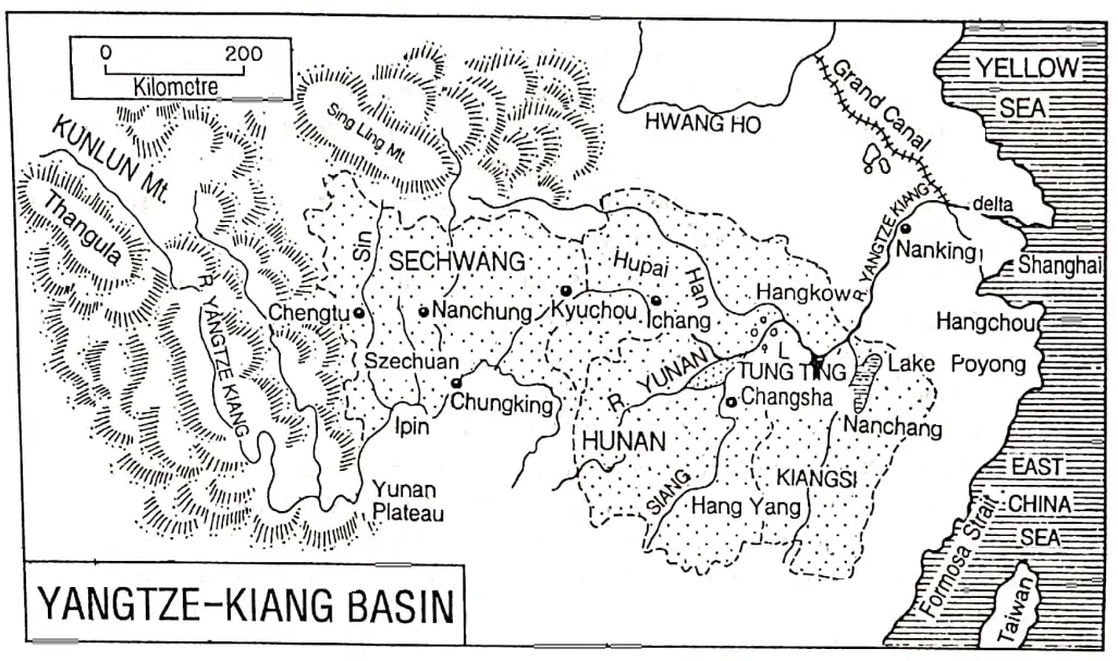
1. The Upper Course Or Szechuan Basin Or Red Basin:

Szechuan means “four streams”. The Szechuan basin is formed by the deposition of four tributaries (Min, To, Wu and Chialing- Kiang) at the source of the Yangtze-Kiang. Most of the Szechuan province in southwestern China Is included in this region.

Except for the Yangtze gorge, this lowland region is surrounded by highlands or mountains. It has been formed by the infilling of silt in an ancient lake. As the soil is red in colour this region is also called the ‘Red Basin’.

The Red Basin extends from the source of the Yangtze-Kiang to Ichang. In terms of climate, soil, terrain and natural resources, Szechuan has no rival.

It is one of the most populous of China’s provinces because of its comfortable climate, extraction of minerals, and agricultural and industrial development. The two important cities and, industrial centres are Chunking and Chengtu.

2. The Middle Course Or Central Basin Of Yangtze-Kiang:

The Middle Course or Central Basin of Yangtze-Kiang is characterized by extensive fertile plains and many lakes. It is extending from Ichang to Hunan. It includes four provinces of Hupeh, Hunan, Kiangsi and Anhwei.

It is one of the greatest agricultural regions. This region prospers in agriculture due to the presence, of

  1. Extensive plain,
  2. Fertile alluvial soil,
  3. Favourable climate and
  4. Development of irrigation, use of chemical fertilizer and high-yielding variety of seeds. This region is a multi-cropping zone. Many food and cash crops are raised.

The southern provinces of Hunan and Kiangsi are famous as the huge quantity producer of paddy. Plenty of rice produced in Hunan province is known as the ‘Rice Bowl of China’ or the “Store house of rice”. Wheat, barley, sugar cane, oil seeds, cotton etc. are also produced here in notable quantities.

As the middle course or central Yangtze-Kiang basin prospers in agriculture it is known as the ‘Granéry of China’. Sericulture is an important occupation. The hill slopes have many tea gardens. The region is rich in mineral resources such as coal, iron ore, tungsten, lead, zinc, manganese and antimony.

The largest industrial conurbation in the Middle Yangtze Kiang Basin is formed by the three cities of Wuhan, Hanyang, and Hankow.

3. The Deltaic Course Or Delta Region Of Yangtze-kiang Basin:

This region extends from Nanking in the west to Shanghai in the east near the East China Sea, the mouth of the river Yangtze-kiang. The entire region lies in Kiangshu province. The delta is almost level, only 10% of it is a swamp.

It is a region with numerous canals, distributaries, lakes, dykes and sand bars, as in Holland (Netherlands) there are many Poldarlands, rivers channels, creeks and lakes. So it is called the “Holland of China” as well as the “Holland of Asia”. This delta region is also called “water country”.

Holland is lowland and gets submerged during high tides. To save the country, the people of Holland erected a number of circular dykes and thereby they have saved the country.

Just like the people of Holland, the people of the Yangtze-Kiang delta region of China also have erected a number of dykes in the delta area of the Yangtze-Kiang and thereby they have reclaimed a vast region.

It is developed in agriculture as well as agro-based industries. Because of the similarity this region is known as the “Holland of China”.

The region is developed in agriculture. Crops produced in the region are rice, wheat, cotton, tobacco, oilseeds soybeans etc. Mulberry trees are cultivated for silkworms. Animal husbandry is also developed here.

Though the region is not important in mineral wealth, yet, some coal, petroleum, salt etc. are produced the region is developed in agriculture.

Nearness to raw materials well-developed transport and communication, cheap labour, hydel and thermal power, wide market, port facilities etc. have favoured the growth of industries here.

The entire delta is developed in the cotton textile industry. Shanghai is the main cotton textile industry centre. So it is also called the “Manchester of China”.

Shanghai has always been the leading industrial centre and well as the largest city in China. Shanghai lies on the Whangpu River, 24 km from the Yangtze.

The growth of Shanghai as the premier port and city of China is due to foreign trade. It has now grown into a metropolis of 10 million people.

Except for cotton textiles, Shanghai manufactures a wide range of products including electrical appliances, bicycles, tractors and chemicals. It also has steel, ship-building and oil-refining industries.


Causes Of Economic Development In The Yangtze-Kiang Basin

The Yangtze-Kiang basin of China is economically developed. The causes of the economic development of this region are as follows:

  1. Extensive Plainland: This extensive plainland helps to expand agriculture, industry and transport.
  2. Favourable Climate: Pleasant and comfortable climate of this region has favoured agriculture, the industry as well as human settlement.
  3. Fertile Alluvium/ Loamy Soil: Fertile alluvium/ loamy soils have favoured agriculture very much.
  4. Plenty Of Water Resources: Plenty of water resources have favoured irrigation facilities, industrial needs, hydroelectric, drinking water supply and as well as fertile silt deposition.
  5. Plenty Of Mineral Resources: Plenty of mineral resources such as coal, iron ore, copper, zinc, tungsten, antimony etc. have favoured industrialization.
  6. Good Transport System: Good transport facilities-railways, roadways, waterways etc. help the region to e economically developed.
  7. Location Of Ports: Port facilities of Shanghai, Nanking, and Chunking Ports are important for the economic development of the Yangtze-Kiang basin.
  8. Good Infra-Structure: Good infrastructure is also helpful for the development of this region.
  9. Development Of Industries: Development of industries such as iron and steel, chemical, silk and cotton textile and tools and machinery also help to the economic development of this region.
  10. Thick Population: Thick population of this region is help to supply the available skilled or unskilled labours for agricultural as well as industrial requirements.


Causes Of Dense Population In The Yangtze-Kiang Basin

The Yangtze-Kiang basin occupies nearly one-fifth of the total area of China. But at the same time, nearly one-fourth of the total population of China lives in this basin. Thus very dense population occurs in this region. The causes of this dense population are as follows:

1. Easy Earning Of Living:

Yantgtze-Kiang Delta region is densely populated because earning of living is easy here.

2. Rich In Agriculture:

The Yangtze-Kiang Basin is the richest agricultural area in China. The region is very fertile as the region is made of fertile silt deposited by the river Yangtze- Kiang. Irrigation facilities have favoured agriculture very much. Rice, wheat, tea, sugarcane, oilseeds etc are produced here.

About 70% of China’s rice is produced from this region, and 50% of other crops too. It results in more earnings from agriculture than any other region of China.

3. Rich In Mineral Resources:

The basin is also the leading mineral-producing region of China. A large amount of iron ore, petroleum, natural gas, antimony, natural gas, tungsten etc. is produced in the region which causes this region to be economically rich resulting in a dense population.

4. Industrially Developed:

The Yangtze-Kiang basin is the most industrialised region of China. Large industrial centres like Shanghai, Wuhan, Nanking, Chunking etc. are located in this basin. Therefore, the development of industries in this region has caused a great density of population.

5. Transport And Communication:

The transport and communication system of this region is well developed, because of roadways and railways facilities.

6. Others:

Amusement, education, games and other facilities are available in this basin has caused it to be the most densely populated region in China.


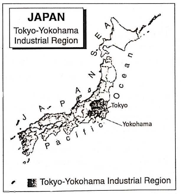
Chapter 9 Continent Of Asia Tokyo-Yokohama Industrial Region Of Japan

At present Japan is the greatest industrialised country in Asia. In the world, it ranks third only following the U.S.A. (1st) and Germany (2nd). The most important industrial region of Japan- the Kihin or Tokyo-Yokohama industrial region has developed in the Kanto plain.

Kanto – (Kwanto) plain is situated in the eastern part of Hanshu Island. Among the four main islands of Japan Hanshu is the largest one. Kanto plain is divided into seven regional divisions, which are

  1. Ganma,
  2. Tochigi,
  3. Ibaroki,
  4. Tsaitama,
  5. Tokyo,
  6. Chiba and
  7. Kanagawa.

The density of the population of the Kanto plain region is very high. About one-third of the total population of Japan lives here. This plain extends around the gulf of Tokyo.

A number of large cities have developed along the coast of the gulf of Tokyo. Within this region, there are forty large towns including Tokyo, Yokohama, Kawasaki and Chiba.


WBBSE Solution For Class 7 Geography Chapter 9 Continent Of Asia Japan Tokyo-Yokohama industrial region


Importance Of Tokyo-Yokohama Industrial Centres

Tokyo:

Tokyo, the capital of Japan is situated on the southeast coast of Hanshu at the head of the gulf of Tokyo. Tokyo is the largest city, important port and the largest industrial and trade centre in Japan.

It is now one of the largest cities in the world and a great centre of Japan’s political, economic and cultural life.

Over 20 million people live within a circle about 50 km from its centre. The city includes vast non-urban areas at the periphery for future growth. So Tokyo is an overbounded city. In contrast, Kolkata is an unbounded city.

Tokyo’s industrial complexes include textiles, cars, food processing, plastics, breweries, optical instruments and publishing. Tokyo is also the largest centre of printing.

Yokohama:

Yokohama is the second-largest city and the largest port in Japan. It is located about 30 km. away from Tokyo in the south of Hanshu island.

The large ships cannot enter the port of Tokyo as the gulf is shallow there. So, Yokohama plays the role of the largest external port in Japan.

Yokohama has steel, motor vehicles, chemicals, shipbuilding, oil refining and also fish canning and silk and rayon manufacturers. Its satellite town Kawasaki has ship-building, steel and textiles. Chiba is noted for its iron and steel industry.


Industrial Region Important Industrial Centres Major Industries
Tokyo-Yokohama or Kihin Industrial Region (Kwanto Plain) Tokyo Cotton textiles, optical instruments, automobiles, electronic equipment, paper, printing and publishing.
Yokohama Steel, motor vehicles, chemicals, shipbuilding, silk and rayon textiles.
Kawasaki Shipbuilding, steel and textiles.
Chiba Iron and steel, chemical, shipbuilding.

Causes Of The Growth Of The Tokyo-Yokohama Industrial Belt

The factors favourable to the growth of the Tokyo-Yokohama Industrial Belt as one of the best and most significant industrial Belt in the world are as follows:

1. Agricultural Development:

The Tokyo-Yokohama region is rich in agriculture. The volcanic fertile soil, suitable climate etc. are ideal for the production of rice and other agricultural crops which are also supplied as raw materials in a number of industries.

2. Favourable Climate:

The insular climate of this region is encouraging and suitable for hard work.

3. Density Of Population:

Being densely populated, the region is supplying a cheap and skilled labour force for industrial development.

4. The Spirit Of The Japanese People:

The spirit of the Japanese people, ‘Nippon Seichin’ has contributed largely to making Japan the industrial leader of the Orient. The Japanese are ready to work harder than almost any person on earth for the sake of their country

5. Power Resources:

Required power is obtained from a large number of hydroelectric power stations of central Hanshu and Tukai nuclear power stations.

6. Water Resources: 

The short and swift-flowing rivers of Japan are helping a lot in the industrial development of this region by providing cheap hydel power and required industrial water.

7. Developed Transport And Communication System:

The region is crisscrossed by a large number of roadways and railways and there helped quick and rapid transport. The numerous natural and man-made water courses on the lowland provide excellent transport facilities.

8. Port Service:

Tokyo-Yokohama ports provide port facilities. Raw materials are imported and final goods are exported through these ports.

9. Uses Of High-Technology:

Uses of high-fi technology favoured this industrial belt to be developed in the field of industries, trade and commerce.

10. Market:

Because of the dense population, the local market and also the international market are wide.

11. Government Policy:

The policy of the Japanese Government is to ensure Japan’s survival in the face of full competition among the western industrial powers.


Industries Of Tokyo-Yokohama Industrial Region

Important industries of Tokyo-Yokohama Industrial Región are as follows:

  1. Iron and steel,
  2. Automobile,
  3. Ship-building,
  4. Cotton textiles,
  5. Woollen textile,
  6. Electronics,
  7. Paper,
  8. Food-processing,
  9. Biotechnology,
  10. Manufacturing of aircraft and machine tools,
  11. Optical instruments, especially cameras and binoculars,
  12. Petrochemicals,
  13. Oil refining,
  14. Printing and publishing,
  15. Information and technology.


Problems Of The Tokyo-Yokohama Industrial Region

Though Tokyo-Yokohama industrial region is the largest industrial belt of Japan, yet at present, this region faces some problems. These are as follows:

  1. Excessive concentration of industrial complexes.
  2. Rapid urbanization.
  3. Decentralisation of different industries.
  4. Scarcity of land
  5. The excessive increase in land value,
  6. Limited transportation.
  7. Lack of cheap labour.
  8. Overpopulation.
  9. Environmental pollution.
  10. International competition.

How Can The Problems Be Solved:

The following remedies should be taken to solve the above problems of the Tokyo-Yokohama industrial region.

  1. To control and prevent industrial pollution.
  2. Proper treatment and reuse of wastes are to be achieved.
  3. To shift the factories to other places. (The Japan Government is considering the shift of the factories to Chiba, Ibaraki cities in particular).
  4. Importance should be given to the reclamation and re-orientation of land use.


Special Features Of The Yokohama Industrial Region

There are some special features of Yokohama Industrial centres in respect of other industrial regions in the world. These are as follows:

  1. Yokohama industrial centre has successfully controlled and prevented industrial pollution.
  2. This city has been declared an ‘eco-friendly city’ by the Government of Japan in 2008.
  3. Importance is given to the reclamation of fallow land to re-orientation of land use.
  4. Importance is given to agriculture to be as important as industries.
  5. This city has been a worldwide trendsetter regarding urban planning.
  6. To restrict the wastage of resources proper treatment and reuse of waste have


Chapter 9 Continent Of Asia Oil Field Of South-West Asia

Petroleum or mineral oil is an inflammable mixture of oily hydrocarbons with very complex chemical properties. It is an important fossil fuel. Modern mechanised civilization is fueled by petroleum.

Petroleum is an important source of power, and lubrication of machines in factories and its most significant use of it is transportation.

Besides, petroleum is used to produce many substances, such as plastic, artificial rubber, artificial fibre etc. It has a wide range of uses and nowadays, it is an invaluable resource.

For its endless usefulness, petroleum is called ‘liquid gold’. Though it is such a precious resource, it is only produced in a few countries of the world.

South-West Asian countries play a very important role in world petroleum production and export. South-West Asia forms a land bridge between Europe, Asia and Africa.

The countries of South-West Asia are known as the ‘Countries of five seas’ which surround South-West Asia.

In the north of South-West Asia lies the Black Sea, in the North-West Mediterranean Sea, in the west the Red Sea, in the south Arabian Sea and in the south-east the Persian gulf.

The countries of South-West Asia are connected with other countries by water routes through one or several of the seas mentioned above and hence called “Countries of five seas”.

The countries of South-West Asia occupy the highest position in the world in respect of petroleum extraction. About 60% of the world’s total mineral oil resources are found in this region.

This region mines about 30% of the total petroleum in the world. The climate in these South-West Asian countries is very hot and dry.

The population of South- West Asia is low and the demand for petroleum is not so high. So, the best part of the oil mined is exported here and the economy of these oil-producing countries is export-oriented.

As they produce and export precious petroleum, gradually oil field-based cities have grown and they live a luxurious life.

The principal producing and exporting centres of South-west Asia are-

  1. Saudi Arabia,
  2. Iraq,
  3. Iran,
  4. Kuwait, The Persian gulf state of
  5. Bahrain,
  6. Qatar,
  7. United Arab Emirates (UAE)
  8. Oman and
  9. Syria.

1. Saudi Arabia:

Saudi Arabia is the largest country in the Arabian peninsula, which is the largest peninsula in the world. At present, it ranks first in the world in petroleum production and export.

About 26% of the total petroleum reserves of the world are found in Saudi Arabia. The oil fields are located along the coast of the Persian Gulf. The on-shore (inland) fields are at Abqaik, Ghawar, Khuryas, Khursania and Al Qatif.

The off-shore fields are Abu Safa, Manifa, Marjan and Safaniya. The largest on-shore oil field in Saudi Arabia, as well as Asia and the World, is Ghawar and the largest off-shore oil field is Safaniya. Dhahran and Rus Tanura (the largest oil refinery in Saudi Arabia) are noted for oil refineries.
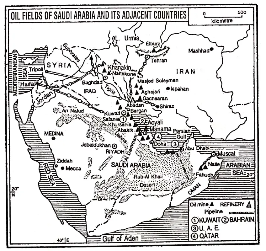
 

WBBSE Solution For Class 7 Geography Chapter 9 Continent Of Asia Oil fields of Saudi Arabia and its adjacent Countries


2. Iraq :

Iraq lies mainly in the lower basin of the Tigris-Euphrates river. Petroleum is easily the most important commodity of Iraq.

Iraq is the fourth largest oil producer in the Middle East. The Kirkuk is the largest oil-producing region. Other oil fields of significance are Mosul, Basra, Warfa- Bargon, Zubain, Rumalia etc.

3. Iran :

Iran lies east of Saudi Arabia and on the other side Gulf of Persia. Petroleum is the most important resource of Iran. In mineral oil production Iran occupies the fourth position in the world and holds the second position among the countries of the Middle East.

The major oil fields are located on the coastal strip of the Persian Gulf and on the foothills of Zagros Mountain. Much oil, nearly half of the total production comes from Aghajari.

Other important oil fields found in this area are-Gachsaran, Lali, Masjid-i-Suleiman, Halftkel, Marun, Naft-i-Shah, Awaj etc. Abadan is one of the greatest oil-refining centres in the world. One-third of the crude oil is refined in Iran.

4. Kuwait :

Kuwait, a small country, on the northeast of the Persian Gulf, is noted for petroleum. The per capita income of the local people is the highest in the world because the per capita production of petroleum is the highest.

Burgan and near it Magwa-Ahmadi produce the maximum oil. More than 80% of the production is piped to Mina-al-Ahmadi port for export.

5. United Arab Emirates (UAE):

U. A. E. is located to the east of Saudi Arabia, adjacent to the Persian Gulf. It is formed of seven Arab Emirates:

  1. Abu Dhabi,
  2. Dubai,
  3. Sharjah,
  4. Ajwan,
  5. Um-El-Koyayan,
  6. Ras-El-Khaima and
  7. Fujairah. Most of the U.A.E. is desert but enormous quantities of petroleum are extracted. Abu Dhabi and Dubai are famous for petroleum production.

6. Bahrain :

In the Middle East Belt, Petroleum was first struck in Bahrain in 1932. Jabal Al-Dukhan is the major oilfield. The oil fields of Awali is also significant.

7. Qatar:

Qatar is a small country located in the east of Saudi Arabia on the coastal margin of the Persian Gulf. Jebel-Dukhan and Id-Al-Sharkhi are important for oil mines.

8. Oman:

Oman, situated on the southeast of the Arabian peninsula, is also noted for petroleum: Fahud and Natih are the major oilfields of the country.

9. Syria:

Syria is nearly self-sufficient in petroleum production and is exporting a little.


Petroleum Producing and Exporting Countries Of South-West Asia Capital Of the Countries Important Oil-Fields
1. Saudi Arabia Riyadh Ghawar, Abqaik, Dhahran, Khuryas, Khursania, Safaniya Manifa.
2. Iraq Baghdad Kirkuk, Mosul, Basra, Warfa-Bargon, Zubafn, Rumalia etc.
3. Iran Tehran Masjid-i-Suleiman, Naft-i-shah, Lali, Aghajari, Halftkel, Gach saran. etc.
4. Kuwait Al-Kuwait/ Kuwait City Burga/i, Magwa-Ahmadi, Aaljara.
5. United Arab Emirates Abu Dhabi Dubai, Abu Dhabi, Murban, Amirshahi.
6. Bahrain Manama Jabal-al-Dukhan, Awali.
7. Qatar Doha Jebel Dukhan, Id-el-ljba, Id-al-Sharkhi.
8. Oman Muscat Fahud and Natih
9. Syria Damascus Al-ljba, Omar.


OPEC:

Most of South-West Asia and a few other petroleum-producing and exporting countries have formed an organization in 1960 to protect their oil resources, and improve their interest and their benefits. T

The organization of the most oil-producing centres of the world is called OPEC or the Organization of Petroleum Exporting Countries. In Asia, these countries include Saudi Arabia, Iraq, Iran, Kuwait, U. A. E, Qatar and Indonesia.

In Africa, they include Gabon, Nigeria, Libya and Algeria. In South America, they include Ecuador and Venezuela. The main objectives of the OPEC are

  1. The determination of oil policy,
  2. The determination of oil price in the international market,
  3. The control of oil production to maintain the price level of petroleum and
  4. To preserve the interest of the members in exporting oil.

The OPEC countries export nearly 80% of the petroleum produced in the world and they have nearly two-thirds of the petroleum reserves of the world.

WBBSE Notes For Class 7 Geography Chapter 7 Water Pollution

Chapter 7 Water Pollution

What Is Pollution: The fouling of the environment by man, which makes it harmful for living organisms or reduces its amenity value is called pollution.

Pollution changes the physical, chemical or biological balance of the environment and has adverse effects on the normal functioning of all life forms, including humans.

Different Types Of Pollution: Pollution may be divided into two major categories :

  1. Physical Pollution And
  2. Non-Physical Or Social Pollution.

Physical pollution may be air pollution, water pollution, soil or land pollution, etc. Social pollution may be defined as a kind of pollution by which the quality of the social environment deteriorates. Population explosion, sociological pollution, economic pollution etc.

Read and Learn More WBBSE Notes for Class 7 Middle Class Geography

On the basis of area and source pollution may be categorised into-

  1. Urban pollution,
  2. Rural pollution,
  3. Agricultural pollution and
  4. Industrial pollution.

What Is Water Pollution: According to the President’s Science Advisory Committee, Washington (1965), water pollution is, “Alteration in physical, chemical and biological characteristics of water which may cause harmful effects on human and aquatic life.”

” class 7 sst geography chapter 5″

According to the definition of the World Health Organisation (1966), water pollution occurs when foreign materials either from natural or other sources are contaminated with water supplies and may be harmful to life because of their toxicity, reduction of normal oxygen level of water, aesthetically unsuitable effects and spread of epidemic diseases.

When Water Is Polluted: When different unsuitable organic matters, germs and force chemicals make water unsuitable for human beings and other members of the biotic world and also make it unhabitable for aquatic life, it is said to be polluted.

Different Types Of Water Pollution: There are mainly five types of water pollution. These are as follows:

  1. Surface Water Pollution,
  2. Ground Water Pollution,
  3. River Water Pollution,
  4. Lake Water Pollution and
  5. Sea Water Pollution.


WBBSE Solutions Geography Class 7 chapter 7 Water Pollution Different types of water pollution


Chapter 7 Water Pollution Sources Of Water Pollution

Point Source: These direct sources of water Pollution may be controlled by the making of laws. These are-

  1. Factories,
  2. Thermal Power Plant and
  3. Atomic Power Plants etc.

Non-Point Source: These indirect sources of water pollution cannot be identified easily. So these are not controlled by the laws Example., Agricultural land, Forests, Dirty water of roads etc.

Pollutants: Something that pollutes the environment is called a pollutant. Pollutants are substances which cause pollution. Pollutants may be solid, liquid or gaseous substances.

Water Pollutants: Something that pollutes and deteriorates the quality of water is called water pollutants. These pollutants may be natural or anthropogenic.

“chapter 5 class 7 geography “

Types Of Water Pollutants :

  1. Industrial Pollutants: Chloride, sulphides, carbonates, nitrates, heavy metals, various organic or inorganic chemical compounds etc.
  2. Agricultural Pollutants: Chemical fertilizers, insecticides, pesticides etc.
  3. Urban Pollutants: Sulphates, nitrates and Potassium contained in urban sewage water.

Water pollutants may also be divided into

  1. degradable or organic pollutants such as sewage, and leaf litter and
  2. non-degradable pollutants, mainly toxic solid substance such as plastic.

WBBSE Notes For Class 7 Geography Chapter 7 Water Pollution

Chapter 7 Water Pollution Causes Of Water Pollution

1. Natural Causes :

  1. Deposition of silt and dust,
  2. Decomposition of organic matters,
  3. Acid rain (water pollution due to air pollution).

2. Anthropogenic Causes :

  1. Household wastes and garbage,
  2. Industrial wastes and effluent poured into rivers.
  3. Agricultural garbage uses chemical fertilizers, pesticides, insecticides etc
  4. Heavy minerals (lead, mercury, cadmium) etc.
  5. Oil spillage from tankers,
  6. Untreated sewage,
  7. Uses of ABS detergent (Alkyl Benzene Sulphonates),
  8. Warm effluent of thermal power plants and nuclear power plants,
  9. Radioactivity
  10.  Arsenic contamination
  11. Fluorine and chlorine.

“water question answer class 7 “

In the following table, the important causes/sources of water pollution are mentioned and indicate how water gets polluted.


Wbbse Solutions for class 7 geography chapter 7

Chapter 7 Water Pollution Water Born Diseases

The diseases such as Diarrhoea, Cholera, Dysentery, Typhoid, Polio, Jaundice etc. are caused by polluted and contaminated water.

Causes Of A Few Diseases Which Are Created By Water Pollution.

class 7 geography chapter 5 water pdf

 Name of the Diseases Causes Problems
1. Arsenicosis 1. Due to the heavy amount of arsenic in underground water 1. Weakness, rough skin, cramps In muscle.
2. Black foot disease. 2. Due to the heavy amount of arsenic in underground water. 2. Besides skin disease, anaemia, and liver and lung cancer can attack.
3. Flourosh 3. Fluoride pollution. 3. Problem with teeth, bones etc
4. Minamata disease 4. Mercury pollution. Problems. 4. Loss of eye-sight, loss of sense of brain.
5. ItaMtai 5. Due to cadmium pollution. 5. High blood pressure, and kidney damage.
6. Dyslexia 6. Due to an excessive amount of lead 6. Decrease of haemoglobin, weakness of muscle vomiting tendency.

Chapter 7 Water Pollution A Few Specific Incidents Of Water Pollution

In 1932, along the coast of Minamata Bay in Japan liquid waste of mercury was thrown. Due to this dreadful mercury pollution in water, Innumerable people and animals died for about three decades.

In 1991, at the time of the Gulf war, many oil wells were ignited in Kuwait by Iraq. A large quantity of mineral oil polluted the water of the Persian Gulf causing the death of countless marine creatures.

Due to the excessive amount of arsenic in underground water of the districts of Malda, Nadia, Burdwan, Hooghly, Howrah, North and South 24 Parganas of west Bengal black wounds are formed and this is called ‘Black foot’ disease.

Due to the water pollution of the Haldi river after the formation of the petrochemical industry at Haldia, the frequent visit of Hilsa fish at the mouth of the Haldi river has decreased.

“class 7 geography chapter 5 short question answer “

Due to Eutrophication fish and other aquatic animals die as the percentage of oxygen in water decreases. The pisciculture at the fisheries of the wetlands of East Kolkata has decreased due to the use of pesticides.

For this reason, a large quantity of fish has died at Kuttuner of Kerala, Kolleru of Andhra Pradesh and Chilka of Odisha.

Water Is Life: Man cannot live without drinking water, perhaps that’s why water, in other words, is called ‘life’. The supply of water for bathing, cooking, drinking, irrigation and industrial purposes is very essential and important.

Crisis Of Fresh Water: Fresh water is the most important natural resource. Though about 71% of the earth’s surface is covered with water bodies, still demand for freshwater remains the main problem for people all over the world.

97% of the water on earth is the saline sea or ocean water out of the remaining 3%, 2% is trapped in ice caps. Only 1% remains in the rivers, lakes underground aquifers and other freshwater bodies.

States Suffering From Acute Water Crisis: Due to overuse and pollution of water severe crisis of fresh water has affected some parts of the world such as some parts of the states of Africa, Australia, West Asia and South America.

Our country India is a land of rivers but presently highly polluted water from the rivers like the Ganges, Krishna, Kaveri, Godavari and Yamuna is not usable as drinking water.

Purifying Water: Recently, even though there is the availability of drinking water for most people in India, the only source of drinking water in remote areas is the river and ponds.

These are full of water but that water is dirty, polluted and not suitable for using as well as drinking. So purifying water is very essential. There are some easy methods by which the purification of water is possible.

  1. Clean water from the upper layer may be used in the case of turbid water.
  2. Most of the bacteria in the water are destroyed by boiling the water for 10 minutes at 100°C temperature.
  3. Bacteria are also destroyed if an adequate amount is mixed with water.
  4. Different types of plants peas and pulses help to deposit all the sediments in the lower level of the container.
  5. Water may be purified in several ways with the help of charcoal, fine sand, pebbles and stone heaps.
  6. If water is poured in to clean plastic bottle and kept in sunlight for six to seven hours, then water as pure as clean boiled water can be obtained.


WBBSE Solutions Geography Class 7 chapter 7 Water Pollution Different ways to purify water


Chapter 7 Water Pollution Prevention Of Water Pollution

Strict controls are needed to prevent water pollution. These are as follows:

  1. Household wastes and garbage should not be thrown directly into ponds, rivers or seawater.
  2. Bathing of cattle and washing of clothes should be banned.
  3. Excessive chemical fertilizers, pesticides and insecticides should not be used in agricultural fields.
  4. Industrial effluents should be effectively recycled so that these pollutants are not released into the water.
  5. Polluted wastewater from urban areas should be thrown into rivers and seas only after treating it properly.
  6. Waste and hot water from thermal or nuclear power plants should be cooled and then thrown into the river or sea.
  7. Radio-active, chemical and biological pollutants can be removed from water by absorption, electrolysis, ion exchange and reverse-osmosis methods.
  8. Pollution of floating oil in the sea can be prevented by the use of various bacteria, algae and chemicals.
  9. For pure and safe drinking water, well and tube well water should be examined regularly and scientifically.
  10. Strict laws should be enforced and persons violating the provisions of pollution control should be penalised.
  11. Mass social awareness should be indicated regarding the nature and effects of water pollution and remedial measures.

“class 7 geography chapter 5 questions and answers “

 What Can Be Done By The Student Of Class Seven?

  1. Household wastes and liquid wastes should be disposed of in such a place so that it would not mix with pure water.
  2. Vegetable plants, plants bearing flowers and fruits should be planted in the house garden and school garden.
  3. They may use things that will not harm the environment (soap, shampoo, detergent etc.)
  4. They may close the open tap or broken tap near their school or house.
  5. They can submit a description of their experience to their school magazine about the importance, purification and supply of water.
  6. Much awareness may be increased by the students if they paste beautiful posters about water pollution water conservation and frequent recycling of water in the surrounding areas of their school or home.
  7. They should think what other ways they can adopt to prevent water pollution.
  8. They should try to get more information about different ways in which water can be reused.

WBBSE Notes For Class 7 Geography Chapter 8 Soil Pollution

Chapter 8 Soil Pollution

What Is Soil?

Soil is a fundamental natural resource. The loose inorganic and organic unconsolidated material that forms the uppermost layer of the earth’s crust is called soil. It consists of many minerals and organic particles, humus, bacteria, etc.

Soil is formed through the chemical and mechanical weathering of rock cover.

Soil Is The Host Of Life: ‘Soil is a valuable gift of nature. It is one of the most useful renewable resources. About one-third (30%) of the earth is landmass and soil covers, the upper level of it.

Mankind has lived and continues to live on the soil. Many human and economic activities depend upon soils.

All our food comes directly or indirectly from the soil. Livestock farming depends upon the raising of grass on different soils.

Read and Learn More WBBSE Notes for Class 7 Middle Class Geography

Soils form an important element for all living things. Soils have affected the march of civilizations. Ancient civilizations developed in fertile river valleys. Fertile soils attract human settlements.

The density of the population depends upon soil fertility and productivity. So it is called that “soil is the host of life”.

soil pollution

What Is Soil Pollution: A decrease in the quality or fertility of soil either due to anthropogenic sources or natural sources or both is called soil pollution.

When Soil Is Polluted?

Soil is polluted when it loses its quality or fertility because of the use of dangerous chemicals such as pesticides and fertilizers and the dumping of industrial wastes, garbage, plastic, and radioactive materials.


WBBSE Solutions class7 chapter 8 Soil Pollution Thermal, nuclear plants


 Soil Pollutants: The soil pollutants may be so chemical and organic or biological types. Some of the pollutants have been reported to be naturally present in harmful concentrations.

“soil contamination effects “

Naturally, present organic pollutants are solanine, gossypol, oxalic acid, and erucic acid. The potential chemical pollutants are fluoride, nitrate, pesticides, radioactive isotopes, and many trace elements, e.g. selenium, lead, mercury, chromium, tin, cadmium, etc.

WBBSE Notes For Class 7 Geography Chapter 8 Soil Pollution

Chapter 8 Soil Pollution Causes or Sources of Soil Pollution

Depletion of valuable land resources or soil is a serious problem almost in every corner of the world. There are numerous sources of soil pollution, but the most important among them are the following three.

  1. Indiscriminate discharge of industrial effluents on land and in water.
  2. Open defecation by animals and human beings especially in rural areas of the country.
  3. Unscientific disposal of solid wastes on land.

In developing countries like India, the major source of soil pollution is, of this type and is prevalent in both urban as well as rural regions.

In the following table, the important causes/sources of soil pollution are mentioned and indicate how soil gets polluted.


WBBSE Solutions Class 7 Geography Chapter 8 Soil Pollution Source of Soil Pollution


Chapter 8 Soil Pollution A few specific incidents of soil pollution

In 1984 at midnight, poisonous gas from the Union Carbide factory in Bhopal (Capital of M.P.), India mixed with air and soil. Many people died and since then many were disabled.

“soil contamination definition “

In 1986 an accident occurred in Chornobyl nuclear reactor in Ukraine and in 2011 an accident occurred in Fukushima Daichi nuclear reactor in Japan. Disastrous radio-active wastes spread on soil, water, and air in surrounding areas, and many people were affected.


WBBSE Solutions class7 Geography chapter 8 Soil Pollution Chernobyl Disaster

“effects of soil pollution on human health “

Effects Of Soil Pollution: Effects of soil pollution on human beings, animals, and plants are far-reaching. Since pollutants degrade the quality of the soil. This results in a substantial decrease in agricultural production.

Chemical pollutants in form of chemical fertilizers, pesticides, and insecticides after reaching the soil eventually reach the human and animal bodies through food chains and cause various diseases and several deaths.


Chapter 8 Soil Pollution Prevention Of Soil Pollution

Much environmental damage has been done in the past – through ignorance or carelessness, and there are now increasingly strict controls to try to prevent further damage.

  1. Control and judicious use of chemical fertilizers, pesticides, and insecticides.
  2. Immediate reduction in the use of D.D.T.
  3. Proper land use and crop management.
  4. Proper disposal of industrial and urban waste.
  5. The garbage generated in India contains about 30% to 40% compostable mats from which good quality manure can be made which not only will lessen pollution but will help increase soil quality.
  6. Use of urban and industrial effluents for irrigation purposes after proper treatment.
  7. Waste disposal on land should be minimized.
  8. Education to farmers about the proper uses of fertilizers.
  9. People should be educated to generate less refusal.
  10. Composting plants should be built in all cities.
  11. The proper research regarding the adverse effects of soil pollutants

“pictures of soil pollution “

In These Ways, We Can Control Soil/Land Pollution.


WBBSE Solutions class7 Geography chapter 8 Soil Pollution Soil-Pollution


“soil pollution importance “

What To Do:

  1. Throw waste of household and garbage in a certain place.
  2. Use of organic manure in agricultural farms instead of chemical fertilizers and pesticides. • Planting more trees in the home garden and roadside.
  3. Use paper or jute bags instead of plastic/polythene.
  4. There is still much to be learned about the harmful effects of chemicals used by farmers, as well as by industrialists…
  5. Making the awareness of the people around the school and home increase.

What Not To Do:

  1. Throwing waste and garbage here and there.
  2. Excessive use of pesticides and fertilizers.
  3. Felling trees and uprooted plants.
  4. Excessive use of polythene and plastic.
  5. Respond to nature’s call outside a proper latrine/toilet/lavatory.

WBBSE Notes For Class 7 Geography Chapter 6 Rock And Soil

Chapter 6 Rock And Soil

In geography, any natural solid material which forms the crust of the Earth is called a rock. A rock is simply an aggregate of various minerals but in the scientific sense, rocks are the materials that make up the earth’s crust.

A rock has no definite chemical composition as minerals. The hardness, color, shape, and rigidity of rocks depend upon their minerals.

Different Types Of Rocks: Based on Their Mode Of Formation, Rocks Are Classified Into Three Types:

  1. Igneous Rocks,
  2. Sedimentary Rocks and
  3. Metamorphic Rocks.

1. Igneous Rocks: Igneous rocks are those rocks that have been formed by cooling. and solidification of lav The word ‘Igneous’ is derived from the Latin word ‘Ignis’ meaning ‘fire’. In the beginning, when the Earth was born, it was just a glowing ball of gas.

Gradually it cooled down and its molten volatile surface solidified.

Read and Learn More WBBSE Notes for Class 7 Middle Class Geography

In this way, the igneous rocks formed at first on the earth’s crust. Hence it is called ‘Primary Rock’. It has no layer and that is characteristic of igneous rocks why it is called ‘Unstratified rock’.

study of rocks and soil

Characteristics :

  1. Igneous rocks are of thermal origin.
  2. Igneous rocks are hard and resistant. They do not break down easily.
  3. These rocks are compact, massive, and crystalline.
  4. There are no layers in this rock.
  5. They do not contain any fossils.
  6. Metallic minerals are common in this rock.

Examples: Granite, Basalt, Dolerite, and Gabro et are examples of igneous rocks. Granite is used for house building and idol-making. Basalt and dolerite is quarried for road-making.


WBBSE Solutions Geography class7 chapter 6 Rock and Soil Igneous Rocks


2. Sedimentary Rocks: A rock composed of sediments and generally having a layered (Stratified) appearance is called ‘sedimentary rock’.

Sedimentary rocks are formed from the sediment accumulated over a long period, usually underwater at the bottom of the sea, ocean, and lakes in layers. Layers are known as strat So, these rocks are also called ‘Stratified Rocks’.


WBBSE Solutions Geography class7 chapter 6 Rock and Soil Formation of Sedimentary Rocks

Characteristics :

  1. Sedimentary rocks are formed by the sedimentation of organic or inorganic materials.
  2. These rocks are stratified.
  3. These rocks are porous.
  4. These rocks are soft and break down easily.
  5. Fossils are found in only this type of rock.
  6. Organic matter, such as coal, petroleum, limestone, etc is found in this type of rock.

Examples: Sandstone, Mudstone, Limestone, Dolomite, Gypsum, and Rock salt et are. important sedimentary rocks. Sandstones and Mudstones are used as house-building materials. Limestone is used as raw materials in cement, chemical iron, and steel industries.


WBBSE Solutions Geography class7 chapter 6 Rock and Soil Fossils & Strata


3. Metamorphic Rocks: Metamorphic rocks are those rocks that have been changed in their form, and color et due to intense heat, tremendous pressure, and chemical action.

Characteristics:

  1. Metamorphic rocks are changed due to heat, pressure, and chemical action.
  2. These are hard resistant rocks.
  3. These rocks are highly crystalline.
  4. These rocks are heavier than other rocks.
  5. No fossils are found.
  6. Pre-existing igneous sedimentary and also metamorphic rocks are changed to metamorphic rock.

WBBSE Notes For Class 7 Geography Chapter 6 Rock And Soil

Example: Examples of metamorphic rocks include granite changes into gneiss, Basalt changes into Amphibolite, Limestone changes into Marble, Sandstone changes into Quartzite and Coal changes into Graphite.

Marble is extensively used by architects. The famous Taj Mahal is made of marble. Slates are used in making blackboards and can be used as a substance for writing.


WBBSE Solutions Geography class7 chapter 6 Rock and Soil Metamorphic rocks


Chapter 6 Rock And Soil From Rocks to Soils

Soils are the top covering of the earth’s surface and have been formed by the wear and tear of rocks and also vegetable and animal matter. The change from hard and rugged rocks to soft, fine-grained soil takes a long time.

The first step in this direction is the disintegration or weathering of rocks.

Weathering contributes much to the formation of soil. Mechanical or physical and chemical weathering plays a very important part in the development of soils, so essential to sustaining every form of life on the earth.

The soil formation process is an extremely slow one. For instance, the development of a soil layer of 2.5 cm may have taken well over a thousand years.

The disintegration of rock by weathering often produces a layer of loose rock materials.

It remains overlying on the bedrock, i.e. the primary rock bed of the region. This covering of loose materials over the primary rock bed is known as ‘regolith’. Soil is derived from regolith by different natural processes.

Biological weathering by plants and animals often plays an important role in information soil. Bacteria, fungi, and protozoa cause the decay of plants and animals.

Burrowing animals also help in it. When all these die and decay, minerals and humus are added to the upper layer of soil (The organic matter in the soil which differentiates from regolith and which comes from animal and vegetable decay, is called humus).

The formation of soil can be understood from the chart given below.


WBBSE Solutions Geography class7 chapter 6 Rock and Soil Formation of soil from rocks


While the chemical action produces the elements so essential for plant growth, it is the mechanical action or the impact of physical forces that gives structure and texture to the soil.

Though soils are derived from rocks there are some differences between rocks and soils. These are as follows:


Rocks Soils
1. Any natural solid material which forms the crust of the Earth is called a rock. 1. The uppermost layer of the Earth’s crust covering loose materials is called soil.
2. Rocks are aggregates of minerals. 2. Rock particles make soil.
3. Rocks are formed by cooling and solidification of lava sedimentation of silts and metamorphism. 3. It forms slowly over a long period by the mechanical and chemical weathering of bedrock.
4. Rocks do not have definite layers. 4. The soil has definite layers.
5. The rock consists of different types of minerals. 5. The soil consists of mineral particles, organic matter (humus), water, air, and living organisms (bacteria).
6. Rocks have a greater depth. 6. Soils are found up to a depth of 2-3 m.
7. Rocks are harder than soils. 7. Soils are softer than rocks.
8. The specific gravity of rock is higher than soil. 8. The specific gravity of soil is lower than a rock.


What Is Soil Made Of :

In the non-living part of the soil, rock waste is produced by weathering and erosion. Its particles are usually composed of gravel, silt, and clay. The living part of the soil contains the roots of the plants, fungi, bacteria, insects, small biting animals et

Living and non-living colloids play an important chemical role in the development of soils.


WBBSE Solutions Geography class7 chapter 6 Rock and Soil what is Soil Made of


Chapter 6 Rock And Soil Factors Of Formation Of Soil

The main factors in the formation of soils are

  1. parent rocks,
  2. Relief,
  3. Climate,
  4. Organic matter (plants and animals) and
  5. Time.


WBBSE Solutions Geography class7 chapter 6 Rock and Soil Factors responsible for soil Formation


1. Parent rocks: Parent materials over which the rock waste and soil develop are the most important factor. The texture and structure of soils depend on the parent rock.


WBBSE Solutions Geography class7 chapter 6 Rock and Soil Horizons and Bed-rock


2. Relief: Ordinary slopes where water drainage is good to have the ideal condition for the development of soil. Steep slopes have thin soil layers, whereas the valleys and lowlands possess thick fertile soils.

3. Climate: Climate is considered to be the most important factor in the development of soil. The most important elements of climate are-

  1. Water or Humidity,
  2. Temperature and
  3. Air or wind.

“the study of rocks and soil “

1. Water or Humidity: Water or humidity is the most important element for the chemical and biological processes of soil development.

2. Temperature: When the temperature is high, chemical and biological activities are accelerated.

3. Air/wind: The role of air/wind is not very important. Air/wind increases evaporation from the soil. The winds erode the upper layers of the soil and transport them to distinct places.

4. Organic Matters (Plants And Animals): The action of animals and plants over the soil is very important. Vegetation is of two types-

  1. Molecular vegetation-Fungi, bacteria et and
  2. Massive vegetation-trees, bushes grasses et The soil gets humus from plants. Animals’.also, help in the development of soil. Earthworms, burrow in the soil and upturn the soil of the lower layer. Ants, termites, dogs, squirrels et also do the same thing.

5. Time: The soil formation process is an extremely slow one. It does not form in a day. For instance, the development of a soil layer of 2.5 cm may be taken well over a thousand years. Soils in wet areas require less time to develop than in dry areas.


Chapter 6 Rock And Soil Soil Types

Soil texture refers to the size of its grains or particles. On the basis of texture, the soil can be divided into the following types.

1. Sand Or Sandy Soil: The rock particles ranging in diameter from 0.02 to 2.00 mm make sand. The sandy soil is dominated by sand. It contains about 80% of sand particles and 20% of clay or silt. Sandstone is a rock, composed of sand grains. Sandy soil has bigger grains and bigger spaces between grains. It absorbs water in no time. It is not suited for agriculture.

2. Clay Or Clayey Soil: The soil composed of the finest rock particles is called clay the size of rock particles is about 0-002 mm the soil contains about 28% of clay and the rest particles or another size. The grains and pore spaces are very small. Water logging is common in such soils. They are better suited to agriculture than sandy soil.

3. Loam/ Loamy Soil: Loamy soils are a mixture of both sand and clay. It contains equal portions of sand and clay. Depending upon a preponderance of the two, they are called either sandy loams or clayey loams. This soil is very well aerated and watered. So, this type of soil is the best suited for cultivation.


Soil Types Silt contains
Clay 0.45
Clay loam 0.42
Loam 0.42
Silt 0.82
Sandy loam 0.14
Sand 0.12


Clay contains Sand contains
0.45 0.1
0.25 0.33
0.18 0.4
0.13 0.05
0.11 0.75
0.08 0.8


“rocks and soils “

Different Characters Of Different Soils :


Types of Soil Grain size Capacity to retain water Crops
Clayey Plate-shaped grains are found in compact and fine grains Water cannot move rapidly through it Rice, Watermelon.
Loamy The grain size of the soil is smaller than sandy soil and bigger than clay because it is a mixture of clay and soil. It is well watered. The best soil for plant growth as well as crops. Sugar cane, pulses, wheat, rice, oil seeds, etc.
Sandy Sand grains are rounded or irregular in shape. They are bigger grains than loams and clay. 1-0-005 It does not hold water well and has large pore spaces between the grains water drains off rapidly. Wheat, oil seeds, melon, etc.


WBBSE Notes For Class 7 Geography Chapter 5 River

Chapter 5 River

Rivers are the most distinctive geographical features on the earth’s surface. They are the most important sculpturing agents of landforms.

Definition Of River: Rivers are channels of running water. A river is a natural stream of running water which flows in a channel along the slope of the land towards a low land which may be an ocean, sea, lake, depression, another stream of water or large water body.

Source Of River: A river begins its flow from a spring, lake or the melting water of a glacier on a high mountain, or a rainy place on uplands and plateaus. The place from where a river begins its flow is called the source of a river.

Mouth Of The River: The place where its flow ends, is called the mouth or confluence of a river. The mouth or confluence of the Ganga is in the Bay of Bengal near Sagar Island.

Read and Learn More WBBSE Notes for Class 7 Middle Class Geography

Catchment Area: The area from which a single river system collects its waters is called its catchment area. Rainwater and ice-melt water drain through several small channels in high. mountainous regions.

These channels generally converse at the foothills to form rivers.

” class 7 sst geography chapter 5″

River Valley: The valley is confined by lateral banks through which the river flows.

WBBSE solutions geography class7 chapter 5 River Valley and River basin

River Basin: The region through which a river, its tributaries and distributaries are flowing is called the River basin.

River-Divide/Water Divide: A high land. (Moutain or plateau) that separates one river basin from another is called a water divide Example. Vindhya Range is a water divide between the northern and southern rivers of India. The tract of land between two adjacent river valleys is called Interfluve or a Doab.

Example. Ganga-Yamuna Doab between the river Ganga and Yamuna.

River System: A river together with all its tributaries and distributaries make up a river system.

Tributaries: A small stream or river that descends to join the larger main stream or river is called a tributary. For e.g. Yamuna is the largest or main tributary of the river Ganga.

Distributaries: On its lower course, particularly near the mouth, several branches come out from the main river and they are known as distributaries, for Example.  Padma and Bhagirathi of river Ganga.

WBBSE Notes For Class 7 Geography Chapter 5 River

Chapter 5 River Distinguish Between Tributary And Distributary


Tributary Distributary 
1. A tributary is a river joining the main river. 1. A distributary is a river draining out of a main river.
2. It increases the volume of water in the main river. 2. It decreases the volume of water in the main river.
3. It joins the main river in its middle course and lower course and helps in the formation of the flood plain. 3. It drains out the main river in its lower course and helps in the formation of the delta.
4. River Yamuna is a tributary of the Ganga. 4. River Ganga has two important distributaries, Example. Bhagirathi in W. Bengal and Padma


WBBSE solutions geography class7 chapter 5 River Tributary and Distributary of a river

Chapter 5 River River Course

The path of a river from its source to its mouth is known as its course. From the source to the mouth of a river, there are variations in the shape, size and depth of the valley. Based on these variations Padma river course is divided into three parts

  1. Upper or mountain course,
  2. Middle or Plain Course and
  3. Lower or deltaic course.

The river which presents these three courses distinctly is called Ideal River. The Ganga is an example of an ideal river.

WBBSE solutions geography class7 chapter 5 River The course of the ganga

Inland River: As the river drains within the country it forms an inland river. A river which has no outlet and so does not reach the sea and empties itself into an inland lake or swamp is called an Inland or Internal or Interior River.

Luni in India is an example of an inland river. Tarim is the longest inland river in the world.

chapter 5 class 7 geography

International River: When a river flows through many countries it is called an International River. Indus, Ganges, and Brahmaputra in Asia, the Rhine, and the Danube in Europe are some examples.

Perennial River: A perennial river has water all the time. When a river has its source high up in the mountainous area is generally fed by ice-melt water and it does not dry up during any time of the year. It is called the Perennial River. The Ganges is an example of a perennial river.

Non-Perennial River: Non-perennial or temporary river tastes life only during the wet season. When a river has its source in a lower plateau or hilly region it is fed by rainwater and it is filled with water during the rainy season during other parts of the year it tends to dry up.

It is called the non-perennial river. River Damodar is a non-perennial river.

What Are The Works Of A River?

A river performs three main types of work:

  1. Erosion,
  2.  Transportation and
  3.  Deposition. The erosion, transportation and deposition go on.. simultaneously. So the work of a river is known as ‘three-way’. work.

Erosion: When a river flows swiftly, it mainly wears away and breaks down its bed and sides. This is erosion. The erosional work of the river depends upon the following factors:

  1. The volume of water,
  2. The velocity of water,
  3. Load of the river,

Transportation: All along the course, the river carries the eroded materials from one place to another is called transportation.

The Transporting Power Of A River Depends Upon :

  1. The velocity of the river,
  2. The volume of water.

Deposition: The work in which the river deposits the transported material is called deposition. Deposition results when

  1. The velocity of the river decreases,
  2. The volume of water decreases,
  3. The load of the river increases,
  4. The transporting power of the river decreases,
  5. The river flows over a plain area with a gentle slope.


Chapter 5 River Relation Of The Power And Energy Of A River with Its works

Energy is the ability to do work and the amount of energy which a river has determines whether it can effectively erode its valley and transport the material it is carrying, or whether it drops the material in the form of a deposition.

The amount of erosion that a river can achieve depends on its energy.

Energy is also needed to transport the pebbles, sand, silt etc. The deposition of materials starts when their energy or power is reduced.

The Energy Or Power Of A River Depends Upon The Following Factors:

  1. Volume Of Water: The ability increases with the rise of the volume of water.
  2. Slope Of The Land: As the slope increases the velocity of flow increases.
  3. A load Of A River: A river with a load of pebbles and stones can erode more.
  4. Nature Of Land: The hardness of land exerts some influence on the work of a river. Soft rocks wear away easily; while hard rocks check the rate of erosion.

How Similar Is A River To A Human Life:

A river while flowing can be said to be like a human being. Its life cycle consists of similar three stages-youth, maturity and old age. A river may be young at its source, mature in the middle course and old near its mouth.

Youthful Stage: In its upper course a river is considered ‘youthful’ because it is young in behaves just like an energetic, restless playful boy. In this stage, it flows rapidly. A young river is most often a very powerful agent of denudation.

Mature Stage: In the middle course a river reaches lower lands. The slope is gradually reduced, so the energy and the speed of the river are reduced. Then the river behaves like a mature person, just as calm and gentle.

“what is ocean current class 7 “

Old Stage: When a river comes close to its mouth, near the sea or the water body into which it is going to empty itself it is called the lower course of a river. Like an old man, in its lower or ‘old’ course a river cannot move fast or straight.

To remain immortal it seeks new ways or distributaries to distribute its tribute of rich silty water.

WBBSE solutions geography class7 chapter 5 River and Man

Chapter 5 River The Mountain Or Upper Course Of A River

The upper course of a river lies in the mountains. Here river water flows very swiftly as it comes down the steep slopes. Erosion and corrosion are both characteristic features of the upper course of the river.

Landforms: The great velocity in the river has many features we see in the land as a result of the forceful down-cutting activity of the river. They are as follows:

Valleys of Different Shapes and Sizes: The valleys which a river in its upper course carves out include V-shaped valleys, gorges, l-shaped valleys and canyons.

1. V-shaped valley: A V-shaped valley is one in which the river flows at the bottom of the valley which is narrow but opens out wider and wider upwards. Such a valley reminds us of the English letter ‘V’. This is why these are called V-shaped valleys.

WBBSE solutions geography class7 chapter 5 River V-shaped Valley

2. Gorge: Very deep and narrow river valley with vertical sides is called a Gorge. A gorge does not have much longer. Both the Indus and the Brahmaputra have carved out deep gorges in the Himalayas. The gorge of the Colca in south-east Peru is the world’s deepest gorge (4375 m)

3. Canyon: In arid or semi-arid areas of the desert little rainfall and rapid down-cutting create longer and deeper very narrow

‘I’ shaped valleys called canyons. The 446 km. long and around 1600 metres deep ‘The Grand Canyon’ of the Colorado river in the U.S.A. is the largest canyon in the world.

WBBSE solutions geography class7 chapter 5 River Gorge and Canyon

Distinguish Between Gorges And Canyons :


Gorges Canyons
1. Gourges are deep and narrow and resemble a narrow V-shaped valley. 1. Canyons are very, deep and extremely narrow, so, they resemble the English alphabet Y.
2. Gorges are formed due to high velocity and rainy mountain areas. 2. Canyons are formed in arid or semi-arid regions.
3. In gorges vertical erosion is greater than lateral erosion/ as rainfall is high, either
river bank gets eroded.
3. In canyons lateral erosion is nearly nil, and vertical


4. Water Falls: When a river waterfalls suddenly from a certain height, along a vertical slope, it is known as a waterfall. Waterfalls are formed in various ways. Some of them are mentioned below:

  1. When a bar of resistant rock lies transversely across a river, a waterfall is formed.
  2. When a fault line scarp caused by faulting stands across a river, a waterfall is formed.
  3. When a river descends from a glaciated hanging valley.
  4. Water plunging down the sharp edge of a plateau forms waterfalls. Niagara Falls in North America is a famous waterfall in the world.The Jog or Gersoppa falls (275 m) on the Sharavati river in Karnataka is the highest waterfall in India and the Salto Angel Falls (979 m) on the Rio Coroni river of Venezuela is the highest waterfall in the world.

WBBSE solutions geography class7 chapter 5 River Water falls and Plunge pool

5. Plunge Pool: The valley floor breaks where the waterfalls and a pool are created at the foot of a waterfall by plunging water. It is called a plunge pool.

6. Rapids Cascades and Cataracts:  When the river flows along the unequal slopes of resistant rocks rapids, cascades and cataracts are formed. These are commonly found in a mountainous regions.

WBBSE solutions geography class7 chapter 5 River Rapids, Cascades and Cataracts

  1. Rapids: A stretch of swift-flowing water where a river bed suddenly becomes steeper is called rapids.
  2. Cascades: Cascades are a series of rapids or. combination of small waterfalls and rapids.
  3. Cataract: A series of rapids of a larger magnitude occurring in the river is called cataracts, as on the River Nile.

7. Potholes: A round hole worn in the rock of river beds by the swirling action of gravel and stones is called Pothole. These features are common on the mountain course of the Himalayan rivers.

WBBSE solutions geography class7 chapter 5 River Potholes and interlocking spur

8. Interlocking Spur: A series of projections from both sides of a river valley which when viewed from above appeared to interlock with each other. This is called Interlocking Spur.

Chapter 5 River The Middle Or Plain Course Of A River

The middle course of a river begins when it leaves the mountain and enters of lowland. At this stage, the volume of water increases as some more tributaries join the river. The ‘river widens its valley.

The river is said to be mature. As the slope of the land becomes gentler in the middle course, the speed and energy of the river are reduced. The main work of the river is transportation. (Though the river also deposits some amount of the materials).

Landforms: The remarkable landforms of this stage are the following:

1. Wide River Valley: As the energy decreases in the middle course of the river due to less velocity, lateral erosion of the river increase while vertical erosion decreases. This widens the river valley and the depth decreases.

WBBSE solutions geography class7 chapter 5 River Wide river Valley

2. Alluvial Fan: A fan-shaped landform composed of alluvium deposition in the foothills where a constricted river enters a main valley or emerges from mountains onto a plain. It is called an alluvial fan or an alluvial cone.

WBBSE solutions geography class7 chapter 5 River Alluvial Fan

3. Meander: A pronounced curve or loop in the middle course of a river channel is known as a meander. It is so named. after the ‘Meanderez’ river of Turkey which has a serpentine or zig-zag or meandering course. The Ganga near Varanasi shows a prominent meandering.


WBBSE solutions geography class7 chapter 5 River Meander


4. Ox-Bow Or Horse-Shoe Lake: In the meandering course, often the river cuts through the two bends of a meander or curve, to flow straight.

The bend or behind the river, this isolated or abandoned part of the river turns into shaped as an oxbow or horseshoe.

So this lake is called Ox-bow or Horseshoe Lake. It is seen in the flood plains of Ganga, near Patna of Bihar.


WBBSE solutions geography class7 chapter 5 River Ox-bow shoe lake


5. Sand Bank, Sand-Bar or River Island: The reduced velocity in the river in the middle course reduces the load transporting capacity of the river. Thus the river deposits a part of the load on its bank and bed.

The large deposits of sand, stones, and pebbles on the river bank are known as sand-bank and the deposits of sand, stones, and pebbles on the river bed are called sand-bars or river islands.

There are many sand banks and sand bars in the course of river Ganga in Bihar and west Bengal and the course of river Brahmaputra in Assam.

6. Flood-Plain and Natural Levee: In the rainy season when extra water is added, the river floods its surrounding areas. By repeated floods sands, and silts deposited on both the banks of a river gradually build up plain.

It is called Flood-Plain.A bank of alluvium bordering a river that is built up by deposition and lies above the level of the flood plain.

As this embankment is formed naturally, so it is called Natural Levee. Natural levees are found along the course of the great rivers such as the Ganga, Howang-Ho and Yangtze.


WBBSE solutions geography class7 chapter 5 River Natural levee and flood plain


Chapter 5 River The Lower or Delta Course of a River

When a river arrives at its mouth near the sea or any large water body slope of the land becomes very much less or gentle, so the velocity is very low.

This part of the river is called Lower or Delta course. From Rajmahal hill in Jharkhand to the mouth of the Ganga at the Bay of Bengal is the Lower or Delta course of the river Ganga.


WBBSE solutions geography class7 chapter 5 River River valley from source to the mouth


Landforms: The very low velocity of the river, the principal work of a river is deposition. The major features produced in this course of the river are:

  1. Very wide river valley,
  2. Flood plains, natural levees, oxbow or horse-shoe lakes, sandbanks sand sand-bar etc. are also seen in the deltaic course too,
  3. Delta, and
  4. Estuary.

1. Very wide (Broad) And Shallow River valley: As the river velocity is low, down-cutting is reduced but side-cutting is increased. So the depth of the river decreases and the valley widens a lot.

2. Sand Bank, Sand Bar, Flood-Plain, Natural Levee And Horse-Shoe Or Ox-Bow Lake: Like the middle or plain course of a river sand bar, sandbank, flood-plain, natural levee and ox-bow or horse-shoe lakes are also formed in the lower course and these are more in numbers.


WBBSE solutions geography class7 chapter 5 River Sand bank in river valley


3. Delta: On entering the sea a river deposits all the load at the mouth to form an alluvial triangular island which looks like the Greek letter Slip-off-slope A (delta). So, this island is called ‘Delta’. The Ganga- Brahmaputra delta is the largest delta in the world.


Chapter 5 River Favourable Conditions For The Formation Of Delta

  1. The river should have a long, mountainous upper course. It increases the load of sediment.
  2. The river should have a long lower course.
  3. The river should have a number of tributaries to increase its load.
  4. There should be an absence of large lakes in the river course.
  5. The sea should be shallow near the delta.
  6. There should be no strong currents and tides at the mouth of the river.

Types Of Beltas: Three types of delta are usually distinguished:

  1. Arcuate or fan-shaped, for Example. Nile delta.
  2. Cuspate or pointed like a tooth, for Example. The Ebro.
  3. Birds foot type with fingering branches Example. Mississippi delta.


WBBSE solutions geography class7 chapter 5 River Types of Deltas


4. Estuary: When a river enters the sea through a deep funnel-shaped tidal mouth where fresh and saline water is mixed. This wide mouth of the river is called the Estuary. The estuary of Ob River is the widest in the world.


Distinguish Between Delta And Estuary


Delta Estuary
1. A delta is a triangular-shaped alluvial land formed at the mouth of a river. 1. An estuary is a funnel-shaped channel formed at the mouth of a river.
2. It is formed by deposition when there is the absence of high velocity of tides and currents. 2. It is formed when deposition does not take place due to strong tides and currents. Lateral erosion also increases here.
3. Ganges-Brahmaputra form a large delta but Narmada-Tapti do not form deltas. 3. River Ganges, Matla, Ob, Amazon etc. have estuaries at their mouths.


How Far Can A River Influence Human Beings

The rivers are closely related to our lives. The relationship constantly changing as men themselves have changed. The importance of the rivers may be summed up as follows:

  1. The rivers are the source of drinking water and other domestic need.
  2. The rivers are an important source of irrigation water and new fertile alluvium.
  3. The role of navigable waterways and sites for ports.
  4. The rivers are the source of industrial water.
  5. We do get temporary benefits when we construct artificial dams on rivers to control floods.
  6. The rivers of the undulating or mountainous surface are the source of hydel power.
  7. These are the sources of fish and mineral ores, e.g. gold and tin.
  8. The rivers are the scavenger of pollutants.
  9. These make our lives developed and prosperous.
  10. River valleys are often suitable for cultivation, urban settlements and the growth of civilizations. The earliest civilizations on earth thrived on the banks of
  11. the rivers (For example. the Indus, the Egyptian, the Sumerian civilization).