WBBSE Notes For Class 7 Geography Chapter 4 Landforms

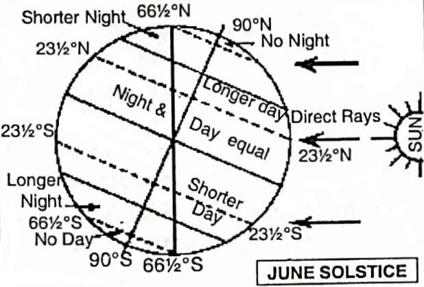
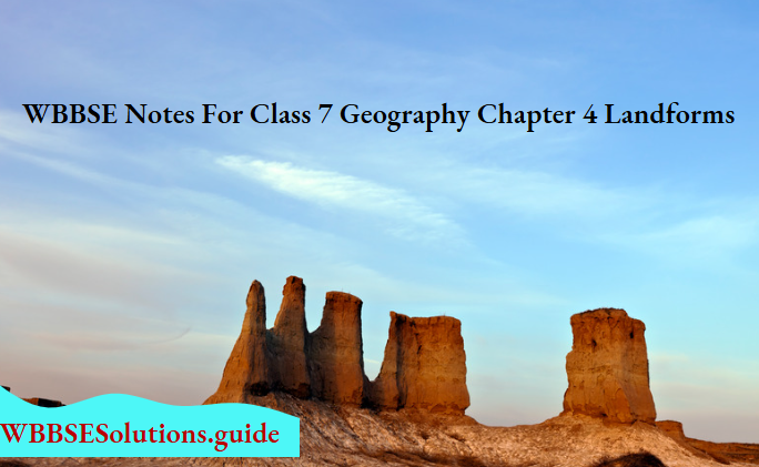
Chapter 4 Landforms Notes

Why are not all places on the Earth’s surface similar?

The surface of the earth which is made of various types of rocks is neither stable nor permanent in its form. Somewhere it is higher, or in others, it is flat and even slopes.

Being subject to pressure, movement, forces of tension-compression, and fracture, the form of the earth’s surface continuously changes.

There are two types of forces working on the Earth’s surface-

Read and Learn More WBBSE Notes for Class 7 Middle Class Geography

  1. Endogenetic forces and
  2. Exogenetic forces.

1. Endogenetic forces have their origin deep down in the earth’s interior and work from below. They can be said to be two types-

Slow forces which bring about subsidence and elevation, cause folds and faults in the crust of the earth and is known as mountain-building activity. These activities are carried on slowly and are called Diastrophism.

The sudden forces include within their scope the earthquake and volcanic eruptions.

2. Exogenetic forces are connected with the atmosphere and consequently are external to the earth. Rain, snow, and sun on one hand and running water (river), wind and moving ice on the other, are always busy leveling down the irregularities of the earth’s crust.

“WBBSE class 7 geography chapter 4 notes”

Out of the continuous action and reaction of these two types of forces- one trying to raise from within the interior and the other trying to level down the raised surfaces- are born the various form seen on the earth’s crust.

These are called landforms and they exercise a very powerful influence on the life and activities of man on this planet on which we live.

The term ‘landform’ is applied by physiographers to each of the multitudinous features that taken together make up the surface of the earth. Any feature of the earth’s surface that possesses. a particular shape and form are called a ‘landform’.

It describes the shape, size, and Mountai structure of the land.
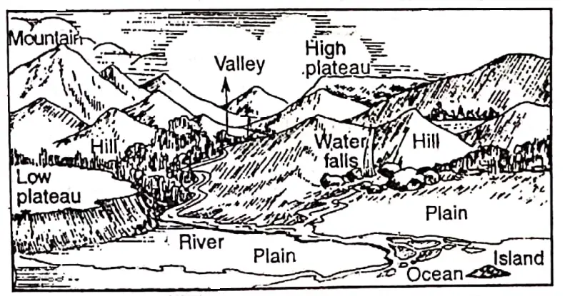
“Major landforms “

A landform is a natural phenomenon of a land area.on the earth’s surface. There are many forms of land on the surface of the erotic earth. Continents, oceans, mountains, plateaus, valleys; deltas, etc.

These are some examples of landforms. Height, slope, and relief are the chief elements giving diversity to landforms.

WBBSE solutions geography class 7 chp4 Landforms land

Landforms Must Have The Following Characteristics

  1. It must have a distinctive surface feature quite different from others.
  2. Its rock structure and general formation must be quite prominent.
  3. It must be so conspicuous that it may be included in any description of physiography.WBBSE solutions geography class 7 chp4 Landforms Major landforms-Heightwise


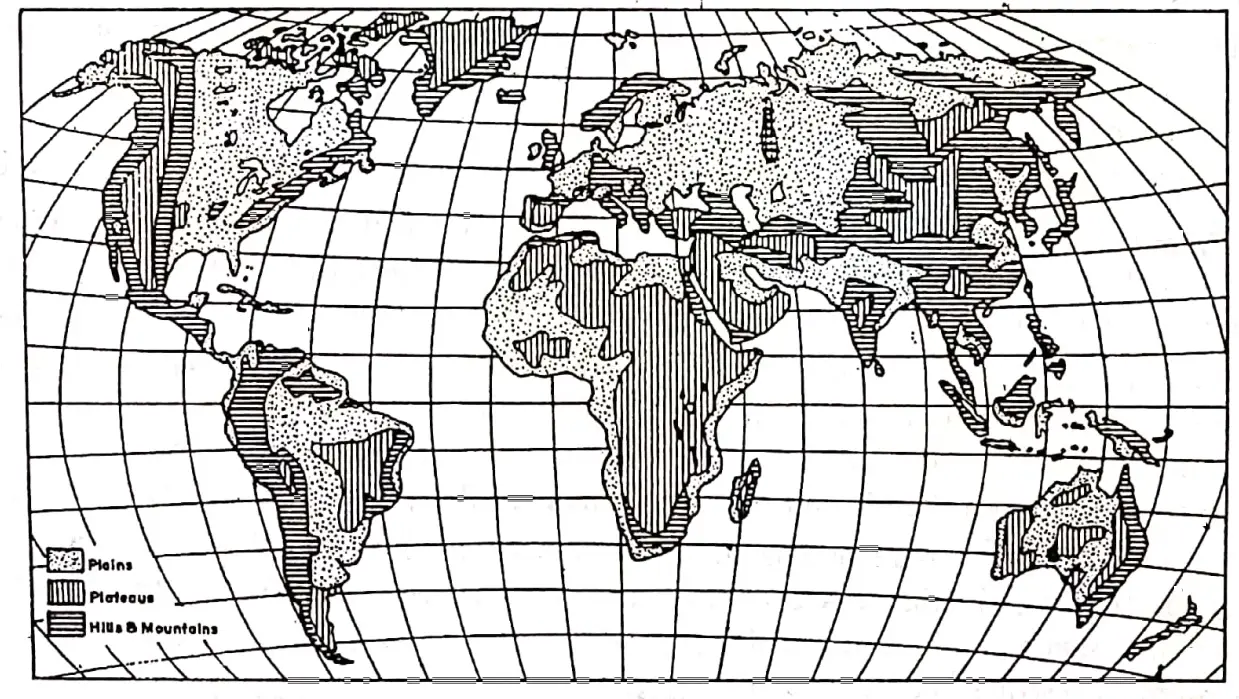
Landforms can be divided into three orders. First-order landforms are continents and oceans. Mountains, 1000 m Plateaus and Plains are among the second-order landforms. The third-order landforms include mountain Sea sections, hills, valleys, deltas etc.

There are three major landforms on the earth basis of height, slope, structure, ruggedness and irregularities.

“various landforms “

These are-

  • Mountains and hills,
  • plateaus and
  • plains.

WBBSE solutions geography class 7 chp4 Landforms Major landforms of the World


Mountains And Hills

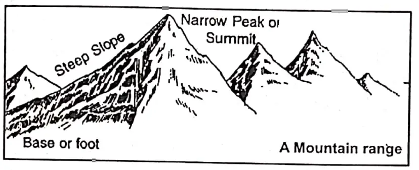
A mountain is a very high, rocky, steep-sided, uneven rugged landmass with a narrow peak or summit.

Characteristics Of Mountains And Hills :

  1. Mountains are the highest lands on earth.
  2. Mountains occupy extensive areas.
  3. These are rocky and rugged landforms.
  4. They are irregular and uneven.
  5. In general, mountains rise to comparatively high altitudes, usually more than 1000 metres.
  6. Most of the mountains are characterised by deep valleys, gorges and long steep slopes.
  7. The lower part or foot of a mountain is called it’s base.

“landforms of the world “

Tops of the mountains have conical peaks. The sharp or narrow pointed top of a mountain is called it summit or peak. A single more or less isolated summit is called a ‘Peak’.

A Mountain Have Several Forms Viz.

  1. Mountain ridge,
  2. mountain range,
  3. mountain chain,
  4. mountain system,
  5. mountain group and
  6. cordillera.

WBBSE Notes For Class 7 Geography Chapter 4 Landforms

    1.  Mountain ridge: A mountain ridge is a system of long, narrow, and high hills.
    2.  Mountain range: A mountain range is a system of mountains and hills having several ridges, peaks/summits, and valleys.
    3.  Mountain chain: A mountain chain consists of parallel long and narrow mountains of different periods.
    4.  Mountain system: A mountain system consists of ‘different mountain ranges of the same period.
    5.  Mountain group: A mountain group consists of several unsystematic patterns of different mountain systems.
    6.  Cordillera: Cordillera is a community of mountains having different ridges, mountain chains, and mountain systems. The mountains region of the western part of North America is the best example of the cordillera.

WBBSE solutions geography class 7 chp4 Landforms Mountain range


Chapter 4 Landforms Mountain Knot

Many mountain ranges spread out in different directions converging or meeting in a highland which is called a Mountain knot. Example-The Pamir plateau of Asia.

Hills: Hills are natural lower highlands of the earth’s surface, not so high as mountains (Considerably ranging between 300 m to 1000 m) and stretching over a less extensive area with less steeply inclined sides. eg. Rajmahal Hills of Jharkhand, Ayodhya, Susunia, Biharinath etc. of West Bengal are examples of hills.

“landforms WBBSE class 7 geography notes”

Types Of Mountains: There are different types of mountains, Based on their mode of formation four main types of mountains can be distinguished-

  1. Folded mountains,
  2. Block Compression mountains,
  3. Volcano or mountain of accumulation and
  4. Relict or residual mountain.image
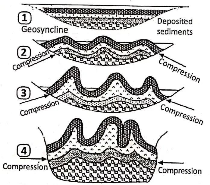
 

Folded Mountain

Folded mountains are formed due to the folding of crustal rocks by the compressive force generated by endogenetic forces coming from within the earth.

Characteristics Of Folded Mountains :

  1. Folded mountains are the youngest mountains on the earth’s surface,
  2. These have been formed due to the folding of sedimentary rocks by compressive forces.
  3. The fossils are found in the rocks of the folded mountains. It means that the sedimentary rocks of folded mountains were deposited in shallow seas.
  4. Folded mountains extend for greater lengths but their widths are smaller than their lengths.
  5. Folded mountains are generally found in an arc shape having one side concave shape and the other side convex slope.
  6. Folded mountains are found along the margins of the continents facing oceans.

WBBSE solutions geography class 7 chp4 Landforms Different stages of fold mountain Formation

Folded Mountains are of two types-

1. Young Fold Mountains:

have been formed during the most recent mountain-building periods. The Himalayas, the Alps, the Rockies and the Andes are prominent examples.

Old fold mountains have formed during earlier mountain-building periods, like the Urals, the Appalachians etc. The Aravallis are considered to be the oldest folded mountain.
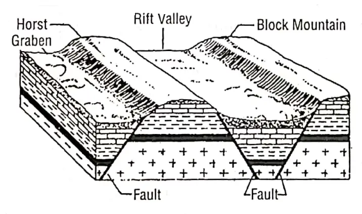
2. Block Mountains:

An upland mass created by the uplift of land through earth movements between faults or by the sinking of the land outside the faults is called a block mountain.

Characteristics :

  1. Block mountains are formed due to forces of tension.
  2. A block between two parallel faults is raised, or the land on either side is dropped below. The upstanding landmass is known as Block mountain or a Horst. The other lower side of the fault seems to be a valley which is called Rift valley or Graben.
  3. These mountains have broad flat tops and steep slopes.
  4. These mountains may be called Fault mountains.

Examples are Black Forest mountain in Germany, Vosges mountain in France, and Vindhyas and Satpuras in India.

WBBSE solutions geography class 7 chp4 Landforms A rift valley and a horst


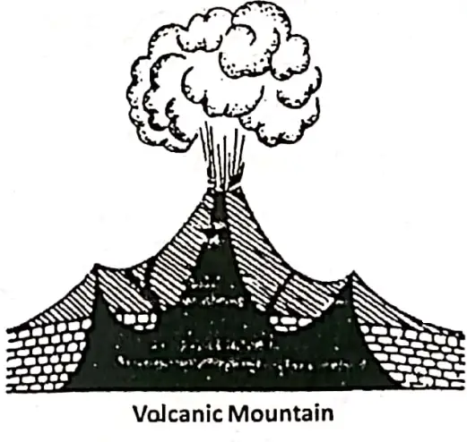
Volcano Or Mountain Of Accumulation

When magma or lava gushing out from the interior of the earth spread and solidifies, a mountain is formed by the accumulation of lava: This type of mountain is called a volcano/a volcanic mountain or mountains of accumulation.

“exercise 4 solved questions on landforms class 7”

Mt. Fuji in Japan, Barren of Andaman island in India, Vesuvius in Italy, and Krakatau in Indonesia are some examples.

“landforms of the earth project “

Volcano Characteristics :

  1. Volcanic mountains are formed by the deposition of volcanic materials like lava, ash etc.
  2. If the lava is basic a flat top is formed; if the lava is acidic a steep-sided top is formed.
  3. These build up a volcanic cone after a long period.
  4. The vendor crater is found in this type of mountain.

WBBSE solutions geography class 7 chp4 Landforms Volconic mountain


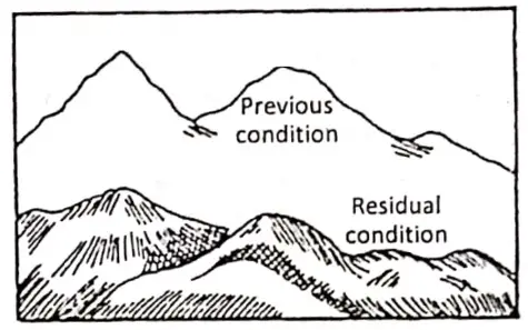
Residual Or Relict Mountain

When an original highland (mountain/plateau) is eroded for a long time, its soft rocks are removed and the hard rocks stand out as mountains. These are called Residual or Relict mountains.

Nilgiris of Southern and Aravalli of North-Western India are examples of this type.

Relict Mountain Characteristics :

  1. These mountains are formed by denudation by rivers glaciers wind etc.
  2. Softer rocks are eroded quickly and height is reduced.
  3. A few hard rocks are left standing these are the remaining parts of once-high mountains or plateaus. The mountain top is rounded and no sharp peaks are visible.
  4. The mountain slope is not steep but gentle.
  5. Their height is not very high.

WBBSE solutions geography class 7 chp4 Landforms Residual or relict mountain


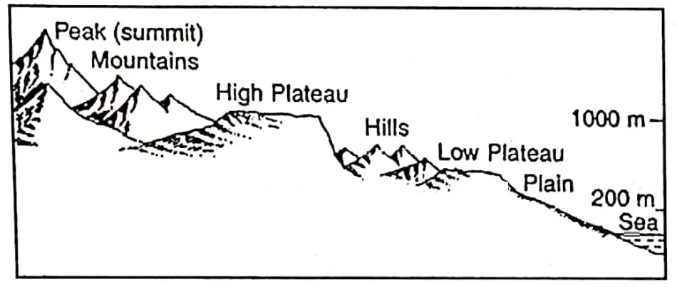
Chapter 4 Landforms Plateau

A plateau is an extensive upland that has an almost flat undulating topped surface with steep sides.

Plateau Characteristics :

  1. Plateaus are extensively flat undulating upland areas with altitudes of above 300 meters from their base level. They have steep sides and deep edges.
  2. They often look like tables standing above the surroundings and for this, they are, sometimes called Tablelands.
  3. The plateaus are of different heights.
  4. Plateaus are the most ancient landmass on the earth’s surface.
  5. The top of a plateau may be undulating or flat.

WBBSE solutions geography class 7 chp4 Landforms Plateau

Formation Of Plateaus:

Plateaus are formed in the following ways-

  1. Sometimes, a vast stretch of land on the earth’s surface rises to a higher level owing to the earth’s movements and forms a pair genic or Continental plateau.
  2.  Vast stretches of South Africa, Antarctica, Greenland and Western Australia are occupied by the Continental plateau. At the time of the fold mountain formation, the Intermontane plateau is formed.
  3. Sometimes lava, thrown out by volcanoes piles up and forms a plateau which is called Lava Plateau. The Deccan Trap is an example of Lava plateau.
  4. Sometimes, Plateaus are formed when the mountains are worn away by the forces of nature like rivers, moving ice, wind etc. Chhotonagpur plateau is an example of this type of plateau. These are called Dissected plateaus.

WBBSE solutions geography class 7 chp4 Landforms Classification of plateau


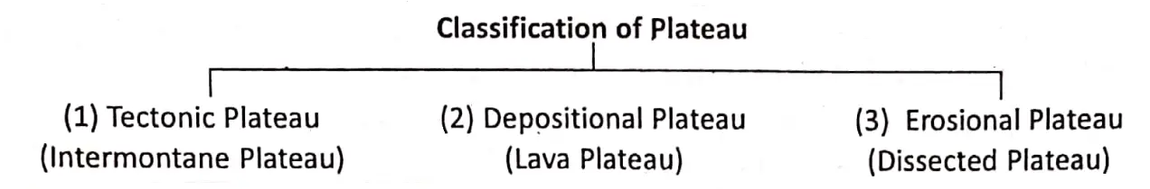
Intermontane Plateaus :

The plateaus which have mountain rims around their surroundings are known as Intermontane plateaus. The upliftment of fold mountains often builds up the intermontane plateaus in between their ranges.

The Tibetan Plateau in between the Himalayas and the Kunlun is an example of this plateau which is the largest and most extensive plateau in the world.

“WBBSE class 7 geography chapter 4 important questions”

The Pamir in Asia is the highest plateau (4873 m.) in the world and that is why it is called the ‘Roof of the world’. The Ladakh Plateau (3500 m) of Kashmir is the highest plateau in India.

Lava Plateau: The Plateaus which are formed by volcanic lava, are called lava plateaus. These plateaus are formed as a result of the lava flow in volcanic regions.

The plateau of Maharashtra, situated in the northwest of the Deccan Plateau in India is an example of this type of plateau.

Dissected Plateaus:

Sometimes, the softer parts of a plateau or highland are worn away by water, glacier, and wind but the harder parts remain as before. The plateau is then divided into a number of uplands and valleys.

It is called a dissected plateau. The Chhotonagpur plateau of Jharkhand in India presents a classic example of the dissected plateau.


Chapter 4 Landforms Plains

An extensive area of flat or near leveled or gently undulating land, usually lowland is called a plain. Plains are formed by the internal earth movements and the external agents of nature, such as the sun, rain, running water, and the glacier.

The plains are formed in the following ways:

  1. Tectonic (Natural, Uplifted, and Depressed) plains are formed by the earth’s movements and earthquakes.
  2. Depositional plains are formed by the deposition of alluvium, lava, sand, etc.
  3. Erosional plains are formed by the agents of erosion and denudation.


WBBSE solutions geography class 7 chp4 Landforms Types of plains


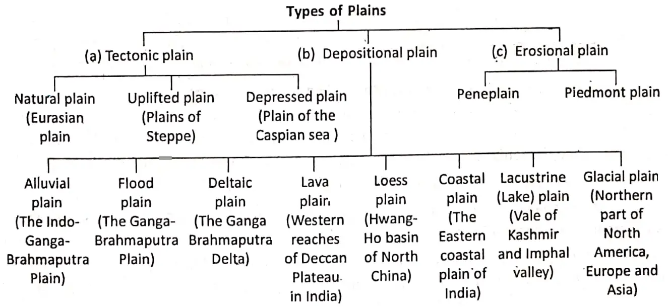
The plains which are formed by the deposition of alluvium are called alluvial plains. The Indo-Ganga-Brahmaputra plain of North India is an example of an alluvial plain.

Lava which is extruded by fissure eruption accumulates over vast, flat low-lying stretches from a plain. It is known as a Lava plain. This plan is found on the margin of the Lava plateaus of the Deccan in India.

“definition and types of landforms class 7 geography”

A plain may be formed by the deposition of fine sand and silts blown by the wind. This is called Loess plain. The largest loess plain of the world is found in the Hwang Ho basin of Northern China.


Chapter 4 Landforms Effects Of Landforms On Our Lives

Landforms exert a significant influence on the life and activity of man. Different types of landform influence differently and for this, we see different types of modes of life on the different parts of the earth. Mountain, plateaus, and plains exert their influence differently.

Influence Of Mountain On Human Lives And Activities :

The Following Are The Influence Of Mountain On the Life And Activity Of Man :

  1. The rugged topography, a thin layer of soil, and rocky surface of the mountainous land are not suitable for agriculture.
  2. Steep slopes and rocky lands hinder the construction of good roads. The forests of the mountain provide timber, fuel, and many other forest
  3. products. Terraced farming is practiced on mountain slopes and some special types of crops and fruit such as tea, orange, apples, etc. are grown on the mountain valley.
  4. Mountain act as a climatic barrier. High and extensive mountain ridges control the climate.
  5. The old and relict mountains are rich in minerals.
  6. Mountains are the source of many rivers. The waterfalls of the mountain offer good sites for the development of hydroelectricity.
  7. Many boundaries are formed by high mountains. These serve as natural barriers between countries. They provide natural boundaries and security.
  8. Underdeveloped communication systems, difficult means of earning a livelihood, etc. cause mountain areas to have scarce settlements.
  9. Beautiful natural scenes of mountains have always attracted tourists to mountains. Entertainment is provided in these areas.

Influence Of Plateaus On Life And Activity Of Man :

The plateaus influence human activities in various ways :

  1. The plateaus are famous for minerals. Many plateaus are rich in many minerals as such they are called ‘storehouses of minerals.
  2. Plateaus are rocky and rugged, so they hinder agriculture. But the rich black soil of the lava plateau in the Deccan provides an example of rich agriculture.
  3. Some plateaus provide mining facilities and the metallurgical industry.
  4. Plateaus are not completely smooth as plains. The rugged and dry surface of the plateaus hinders transport and communication.
  5. The rugged surface of the plateaus does not favor navigation. However, the swift-flowing rivers are favorable for hydroelectric power generation.

“formation of mountains, plateaus, and plains WBBSE”

Compared to mountain regions transport and communication network is developed in plateau areas and earning of a livelihood is easier. Thus human settlements are moderate in density.

Influence Of Plains On Life And Activity Of Man :

Plains are smooth for human habitation and easy living. The plains exert tremendous influence on human lives and activities. They may be enumerated in the following ways:

  1. Plains are open fields with open-air environments.
  2. Fertile plains are the best areas for agricultural development.
  3. The plains provide the best facilities for transport and communication.
  4. Plains in many ways offer facilities for human settlement and encourage economic activities.
  5. The agricultural products of the plain provide raw materials for many agro-based industries. These industries support a high density of the population.
  6. The fertile alluvial plains are the birthplace of ancient civilization, culture, and learning.

WBBSE Notes For Class 7 Geography Chapter 3 Air Pressure

Chapter 3 Air Pressure Notes

An important element as well as one of the basic elements of weather and climate is air pressure.

Air is made up of several mixed gases and it has weight. The weight of a column of air above a given place determines the air pressure at that place.

Air pressure is much more important than climatic control because small pressure changes are the cause of winds which may induce remarkable variations of general weather conditions. It is very significant in our daily life.

Read and Learn More WBBSE Notes for Class 7 Middle Class Geography

Does air exert pressure?

All materials and all forms of life, including man are affected directly by the slight air pressure exerted on it.

Air exerts pressure from all directions but we do not feel this pressure because our body’s internal pressure is equal to that exerted by the atmosphere.

This is the reason why we do not feel internal or external pressure on ourselves.

Why does air exert pressure?

As the air has weight it exerts pressure on the earth’s surface. If a definite volume of air has many air molecules its weight or pressure will be high and if the same volume of air has few air molecules it’s weight or pressure will be low.

Molecules of a gas wander around loosely and often collide with each other.

When these molecules hit an object, the impact thus created is generally considered air pressure.

“WBBSE class 7 geography chapter 3 notes”

The distance between molecules decreases with decreasing volume of the gas thus the density rises and so does the incidence of collision between the molecules, thereby increasing the pressure.

Is air pressure the same everywhere?

Like temperature air pressure is not the same at all places on the earth. It depends on altitude, temperature and the amount of water vapour in the air. The air pressure is maximum at sea level.

It decreases with the increase in height or altitude. This is because at great heights the air is thinner or less dense than the air at sea level.

The column of air at sea level is the highest. It decreases as we go higher. This decreased column of air exerts less pressure. Normally, the pressure of air at the sea level is 76 cm. but it decreases at the rate of 1 cm.

for every 110 metres of ascent. When the temperature of a place rises, the air expands. So it becomes less dense and exerts less pressure.

When the temperature falls, the air becomes denser and its pressure increases. For example, the pressure at the Equator is low while it is high around the poles.

Since the air pressure decreases with increasing altitudes and therefore the balance, between the outward pressure exerted by the air of the human body and the inward pressure exerted by the atmosphere is disturbed.

As the result, man suffers from nose and ear bleed at higher altitudes in the mountains.

Characteristics Of Air Pressure :

  1. Air pressure decreases with increasing height, e.g.-air pressure is low adjacent to high mountain peaks.
  2. Cold air is heavy so its pressure is more. In winter air pressure is higher than in summer or again in polar regions, high pressure is found.
  3. Warm air is light so it has low pressure, e.g. the high temperature in summer in the desert region of Rajasthan is responsible for the deep low pressure created in this region.
  4. Water vapour is a lighter element of the atmosphere so compared to dry air, air rich in water vapour is lighter. So in the monsoon season air pressure is lower compared to the other times of the year.
  5. When air pressure rises, it forms anti-cyclones and if the pressure falls very rapidly over a region it creates cyclones.

WBBSE Notes For Class 7 Geography Chapter 3 Air Pressure

Chapter 3 Factors Affecting Air Pressure

Causes Or Factors Of Variation Of Air Pressure

A study of the distribution of air pressure reveals that the air pressure is not uniformly distributed over the Earth’s surface air pressure varies from place to place and time to time due to the following causes/factors:

1. Temperature – As the air is heated it expands and rises upward. On the other hand cold air contracts and becomes heavier. Thus pressure has an inverse relation with temperature. High temperature causes a decrease in air pressure.

When the temperature decreases, the air becomes heavier and denser. Hence, it descends and as a result, air pressure increases.

For example, Equatorial regions have high temperatures throughout the year and therefore, they always have low pressure. On the other hand, the polar areas record low temperatures throughout the year.

Therefore, they always have high pressure.

2. Altitude – Generally air pressure decreases with increasing altitude because the lower layers of the atmosphere are the densest as the weight of all the layers above rests upon them.

The pressure decreases at the rate of one inch or 34. millibars for every 300 metres. The following table gives the standard relation between air pressure and altitude.

WBBSE solutions geography class 7 chp3 air pollution Effect of Altitude on air pressure

Altitude in metre Air Pressure in
millibars 
Sea Level 1013.25
1000 898.76
2000 795.01
3000 701.21
4000 616.6
5000 540.48
10000 265
30000 11.85


It is estimated that about one-half of the atmospheric pressure lies up to a height of 5 km. There is a rapid decrease in pressure with increasing altitude. This fact is easily experienced by mountaineers.

Due to the drop in air pressure the boiling point of water drops in mountainous regions.

Their water starts boiling at a temperature below 100°C when the air pressure drops. So, it is difficult to ‘boil rice or anything for that reason.

As the air gets thinner with altitude oxygen in the air reduces too.

“air pressure WBBSE class 7 geography notes”

So, mountaineers experience breathing and other troubles while they are scaling high peaks.

Due to low pressure, blood oozes out of their nostrils and their lungs work feverishly. If the air pressure is very low the mountaineers fall down and lose consciousness.

So, mountaineers have to carry oxygen cylinders to breathe freely when they’ll travel to very high altitudes.

3. Water vapour / Moisture-laden air – Water vapour in the air, often called vapour concentration on moisture-laden air is lighter than dry air. Therefore, dry air is heavier than wet or humid air.

Due to this reason, land winds are heavier than sea winds which are laden with water vapour.

As a result, low air pressure is generated by moisture-laden air and high air. pressure is generated by the dry air.

4. Rotation of the Earth – The rotation of the earth also causes differences in pressure. The earth’s rotation leads to the sinking of air in certain places and the ascent of air in other places.

The earth’s rotation is responsible for the formation of the sub-tropical high-pressure belt and the sub-polar low-pressure belt in each hemisphere.

Classification of Air pressure: There are two types of air pressure-

  1. High Pressure and
  2. Low Pressure. High pressure and Low pressure mean the number of air molecules that is present in a definite volume of air.

1. High Pressure – If a definite volume of air has many air molecules the weight or pressure will be high. If the barometer has an air pressure level of 1013-25 millibars or more the condition is known as ‘High Pressure’.

2. Low Pressure – If a definite volume of air has few molecules, its weight or pressure will be low. If it is 986 millibars or less it means Low Air Pressure.


Chapter 3  Distinguish Between The High Air Pressure And Low Air Pressure


High Air Pressure Low Air Pressure
1. Any pressure higher than the surrounding air pressure is called a ‘high air pressure’. 1. Any pressure less than the surrounding pressure is called a ‘low air pressure’.
2. A high-air pressure area is usually cold and compacted. 2. A low air pressure area is usually warm, light and expanding.
3. High air pressure is found in cold temperate and polar regions. ‘ 3. Low air pressure is found in the Equatorial and tropical regions.
4. In high air pressure areas cold and heavy air naturally sinks towards the earth’s surface, gets denser and exerts higher pressure. 4. In low air pressure areas warm and light air rises upwards and the ascent of air creates low pressure.
5. In high-air pressure areas air is generally cold, dense and dry. 5. In low-pressure areas air is generally hot and humid.
 6. Generally calm weather and clear sky prevail in high air pressure 6. Cloudy, rainy, stormy and turbulent weather prevails in low-air pressure areas.


Measurement Of Air Pressure :

The normal or standard air pressure at sea level is 1013-25 Mb (millibar). The unit of the force to measure air pressure is called a ‘bar’. A ‘bar’ is divided into 1000 millibars.

Millibar is a force equal to 1000 dynes per cm2 whereas a dyne is a unit of force approximately equal to the weight of one milligram or 29.92 inches or 76 cm.

At a temperature of 15° C at the latitude of 45. The common unit to measure air pressure is a millibar. Actual air pressure on the earth’s surface is found to vary between 940 and 1040 millibars.

Relation Between Different Units Of Air Pressure :


WBBSE Solutions geography class7 chp3 air pollution fortin's barometer


29.92 inches 1 inch
76 cms 1013-25 millibars
33-86 MB or 34 MB
1 cm = 13.3 MB.

The instrument used to measure air pressure is called a ‘barometer’. It was Torricelli, a disciple of Galileo, who first partially measured air pressure in 1643.

The simplest but most accurate instrument used for measuring air pressure is a mercury barometer.

It consists of a long narrow glass tube filled with mercury.

The tube is inverted and immersed in a vessel containing mercury. The pressure of the atmosphere on the mercury in the vessel is able to balance mercury.

Column of 76 cm in height. The mercury column is acting as an instrument for measuring the air pressure. Mercury is used in the barometer because it is the densest liquid.

This instrument is called an Ordinary Barometer or Torricellian Barometer. The most common barometer using mercury is called ‘Fortin’s barometer’.

Fortin reformed the ‘Ordinary Barometer’ to construct a better barometer. This barometer measures the air pressure very correctly but it has to be kept hanging by a nail in contact with the wall.

“exercise 3 solved questions on air pressure class 7”

It is not convenient to take the barometer from one place to another. Nowadays air pressure is easily measured by an improved handy portable instrument called the Aneroid barometer.

An Aneroid barometer consists of a flat metal box with a vacuum chamber with expands or contracts as the air pressure changes.

The movements are picked up by levers which move the needle on the face of the instrument.

It can be taken easily for fieldwork. So mountaineers, aircraft pilots and most other people use this barometer to find both air pressure and height climbed.

The continuous changes in air pressure are recorded employing a curve drawn or scaled paper called a ‘barogram’.

“relationship between altitude and air pressure class 7”

A ‘barograph’ is a self-recording instrument which records changes in pressure by a curve on graph paper mounted on a rotating drum.

The altimeter is an instrument which helps to read the altitude of a place directly from its dial.

It works on the principle that the air pressure falls with altitude at a rate of about.11 MB per 100 metres of height.


WBBSE solutions geography class 7 chp3 air pollution Aneroid barometer


Distribution Or Variation Of Air Pressure On The Earth :

Distribution or variation in air pressure in the atmosphere is not uniform over the earth’s surface. It varies vertically as well as horizontally.

Vertical Distribution Of Air Pressure :

The pressure exerted below from the overlying layers of air or that exerted from above to the air below is called vertical air pressure.

Near the earth’s surface air pressure is very high because it has to withstand the weight of the overlying layers of air.

“factors affecting air pressure WBBSE geography”

Thus the air pressure gradually decreases upwards from the earth’s surface. In general, the air pressure decreases on an average at the rate of about 34 millibars per every 300 meters of height.

Horizontal Distribution Of Air Pressure :

The pressure exerted by moving horizontally is called horizontal air pressure. The distribution of air pressure across the latitudes is termed global horizontal distribution.

Its main feature is its zonal character known as ‘Pressure belts’.

On the earth’s surface, there are in seven pressure belts.


WBBSE solutions geography class 7 chp3 air pollution Pressure belts of the earth


Chapter 3 Isobar

Isobar is a combination of two words (Iso Equal and Bar Pressure). So isobars are linesIsobar is an imaginary line joining the places of equal air pressure at a particular time reduced to sea level.


WBBSE solutions geography class 7 chp3 air pollution Isobar Lines

“definition and concept of air pressure class 7”

If a place is 300 metres high and its actual pressure is 900 MB. Its pressure reduced to sea level would be 900+34 934 millibars because the pressure decreases at the rate of 34 millibars for every 300 metres.


WBBSE solutions geography class 7 chp3 air pollution World Isobar map january


Characteristics of Isobars :

  1. The Isobars generally run in an east-west direction.
  2. The Isobars do not intersect or meet each other.
  3. These are more regular in oceans than on land.
  4. The Isobars represent air pressure measured in millibars.
  5. These separate areas of high pressure from areas of low pressure.
  6. The Isobars are used to show the distribution of pressure on weather climatic maps.
  7. In the southern hemisphere, these closely follow the line of latitudes.
  8. The spacing of isobars shows the direction and velocity, of wind pressure

WBBSE solutions geography class 7 chp3 air pollution World Isobar map july


 Chapter 3 Air Pressure And Movement Of Air

The study of air pressure patterns on the globe is important as it is directly responsible to make the air move. It also decides the direction and pace of the movement of air.

Air moves from an area of high pressure to an area of low pressure.

The rate of change of the air pressure between two points on the earth’s surface is known as the ‘pressure gradient’.

When the movement of air is horizontal it is called wind. The wind velocity is high in an area of steep pressure gradient and it is low in an area of a gentle pressure gradient.

“WBBSE class 7 geography chapter 3 important questions”

When the movement of air is vertical or nearly so, it is called an air current.

The direction of the wind is also influenced by the rotation of the earth.

The direction of the planetary winds is affected by the earth’s rotation and follows a simple pattern.

Periodical winds are felt only during certain times or during certain parts of the year. Local winds circulate over a comparatively small area.

Variable winds are mainly two types-Cyclones and anticyclones.

Winds rush towards the depression from all directions, called cyclones; they bring bad weather, rain storm, hail and snow which sometimes cause widespread destruction and loss of life. Anti-cyclones are gentle and bring fair weather with them.

WBBSE Notes For Class 7 Geography Chapter 2 Determination Of The Position Of A Place On The Earths Surface

Chapter 2 Determination Of The Position Of A Place On The Earth’s Surface

The location of a place on the rotating earth is of vital importance. The most important aspect of Geography is to find out the location of a place on the earth’s surface. Because of the spherical shape of the earth, it is very difficult to fix the position of a point about the whole of the earth.

We know that the location or distance between two places on a flat surface is measured by a tape or rope in inch, foot mile etc. or cm, metre, km, etc. This is called ‘Linear distance’.

But the distance or location of a place on a spherical or curved surface is measured in seconds, minutes and degrees. This is called ‘Angular distance’.

“WBBSE class 7 geography chapter 2 notes”

The distance between any two places on a curved earth’s surface is measured by the angle made by two straight lines that meet at the centre of the earth from the two places on the earth’s surface is called ‘Angular distance’.

Read and Learn More WBBSE Notes for Class 7 Middle Class Geography

So, the location of a place on the earth is determined by angular measurements. For e.g. Kolkata is located at 22°34′ north latitude and 88°24′ east longitude.

WBBSE Solutions class 7 Geography chapter 2 Determination Earth by angular distance

Chapter 2 Determination Of The Position Of A Place On The Earths Surface Determination Of The Location Of A Place On A Flat Or Plane Surface

location of a student in the classroom can be marked by two reference lines namely the ‘rows from the teacher’s table and the number of seats from the entrance to the classroom.

Therefore to find out the location of student ‘S’ in the rectangular classroom ABCD, parallel lines are drawn from the sides of AB (Line of Teachers table), AC (Line of the entrance of the room) cl intersecting at ‘S’, ‘P’ i.e. R.T. and P.Q.

“class 7 social science geography “

Now the actual location of the student (S) in the classroom (ABCD rectangle) can be found by measuring the distance of ‘RS’ and ‘PS’.

WBBSE Solutions class 7 Geography chapter 2 Determination of the position of a place on the earths surface location on a plane surface

Determination of the location of a place on a spherical or curved earth surface :

In order to locate each and every place on the earth’s surface correctly, a network of horizontal and vertical lines is drawn on the globe. This network of lines is called the ‘Earth Grid’.

The location of any place on the sphere is to be determined with the help of imaginary lines encircling the earth is an East-West and North-South direction.

WBBSE Solutions class 7 Geography chapter 2 Determination of the position of a place on the earths surface Earth Grid

East-West Extended Lines Or Parallels Of Latitudes :

The imaginary East-West extended circles including the Equator and the two poles are known as parallels of Latitude. The parallels lying north of the Equator is know as the north parallels of latitude and the parallels south of the Equator as the south parallels of latitude.

WBBSE Solutions class 7 Geography chapter 2 Determination of the position of a place on the earths surface Parallels of Latitudes on the Globe

The Equator :

The Equator is an imaginary line on the globe passing through the midpoints between the North Pole and the South Pole. It is a circle whose centre is the centre of the globe. The Equator divides the globe into two hemispheres.

The hemisphere that lies north of the equator or that contains the North Pole is known as the Northern Hemisphere and the hemisphere south of the Equator or that contains the South Pole is the Southern Hemisphere. The word ‘hemisphere’ means half of a sphere or a globe.

The Equator is also called the Great Circle because it is the greatest parallel and other parallels decrease in size gradually. Another name for the Equator is the Line of Equinox because throughout the year the equatorial region has equal lengths of day and night.

“determination of the position of a place on the earth’s surface WBBSE”

WBBSE Solutions class 7 Geography chapter 2 Determination Chapter 2 Determination Of The Position Of a Place On The Earths Surface The Equator divides the earth

Importance Of The Equator :

1. The Equator divides the earth into two hemispheres. It helps to know about the position of a place is how much north or south on the earth’s surface.
2. The Equator also helps to find out the latitude of a place on the earth’s surface.

WBBSE Notes For Class 7 Geography Chapter 2 Determination Of The Position Of A Place On The Earths Surface

The Equatorial Plane :

The plane bounded by the Equator of the earth is known as the Equatorial plane. If the earth could be sliced into two halves all along the Equator, the Equatorial plane could be seen and the earth could be divided into two halves.

Latitude :

The latitude of a place on the earth is the angular distance of that place north or south of the Equator. If a line is drawn from any place to the north or south of the Equator to the centre of the earth, the angle formed by the line with the equatorial plane is the angular distance of that place.

This angular distance is the latitude of that place.

“exercise 2 solved questions on determination of position class 7”

Example :

The Latitude of Kolkata is 22°34′ north. The word ‘North’ ‘means Kolkata is located in the northern hemisphere and 22°34’ indicates the angle produced by a straight line joining Kolkata and the centre of the earth and the Equator drawn on the Equatorial plane.

Based on latitude, we also describe different regions of the earth as under.

Low Latitude: The region between the Equator (000 and 30°N or S.

Mid-latitude : The region between 30° and 60° N and S

High Latitudes: The region between 60° and 90° N and S. (Polar region)

Importance Of Latitudes :

1. It helps in the location of a place for latitudes and shows how a place is north and south of the Equator.
2. Latitudes are used to divide the earth into temperature belts. Thus the latitude of a place gives an idea about climate.

Parallels Of Latitude Or Line Of Latitude

On either side of the Equator east-west extending imagináry circles, lying parallel to each other are called Lines of Latitude or Parallels of Latitude.

WBBSE Solutions class 7 Geography chapter 2 Determination of the position of a place on the earths surface Latitude is the angular distance

Chapter 2 Determination Of The Position Of A Place On The Earths Surface Difference Between Latitude And Parallels Of Latitude

Latitude is the angular distance of any place north or south of the Equator. Parallels of Latitude means an imaginary line joining an infinite number of places having the same angular distance from the Equator. They are mainly extensive east-west trending circles.

Characteristics of Parallels of Latitude :

  1. Parallels of Latitudes are imaginary full circles on the earth, all parallel to the Equator. i.e. they always remain an equal distance apart.
  2. All parallels represent true east-west lines.
  3. Parallels intersect meridians. at right angles. This fact holds true for any place on the globe, except the two poles.
  4. All parallels except the Equator are smaller circles.
  5. The Equator is a Great Circle and the only parallel drawn from the earth’s centre.
  6. An infinite number of parallels may be drawn on the globe. Therefore, every point on the globe, except the North Pole or the South Pole lies on a parallel.
  7. Latitudes are of the same value in both the northern and southern hemispheres. But more than one latitude of the same value does not exist in one hemisphere.
  8. The value of latitudes is measured from the Equator (0°) northwards to the point of the North pole (90°N) and southwards to the South Pole (90°S).

Important Parallels Of Latitude :

Important lines of Latitude and their distance from the Equator in degrees are given below.
The Equator = 0°
Tropic of cancer = 232 or 23°30′N, Tropic of Capricorn = 23°30’S.
Arctic Circle = 66°30′ N and Antarctic Circle = 66°30’S. North Pole 90°N, South Pole.= 90°S.

“what is terrarium class 7 “


WBBSE Solutions class 7 Geography chapter 2 Determination Chapter 2 Determination Of The Position Of a Place On The Earths Surfaces some important parallels of latitude

Chapter 2 Determination Of The Position Of A Place On The Earths Surface North-South Extended Lines Or Meridians Of Longitude

Lines of longitude or Meridian of Longitude are imaginary lines joining places located at the same angular distance east or west of the Prime Meridian.

Prime Meridian :

North-south extended semi- circular the particular imaginary line drawn along the Royal Observatory of Greenwich near London is called the Prime Meridian whose value is 0°. This is also known as Greenwich Meridian.

WBBSE Solutions class 7 Geography chapter 2 Determination of the position of a place on earths surface prime Meridian divides the earth

Importance Of Prime Meridian :

  1. The Prime. Meridian divides the earth into two equal halves or the eastern and western hemispheres.
  2. It helps us to know about the position of a place is how much east or west is on the earth’s surface.
  3. The local time of the prime meridian is known as Greenwich Mean Time or G.M.T. It is accepted all over the world as the standard time.

Longitude :

The longitude of a place on the earth is the angular distance of that place east or west of the Prime Meridian. The angle formed by the location of any place east or west of the Prime Meridian to the centre of the earth and the plane of the Prime Meridian is called the longitude.

Example :

The Longitude of Kolkata is 88°24′ east. The word ‘East’ means Kolkata is located in the eastern hemisphere and 88°24′ indicates the angular distance of Kolkata from the Prime Meridian.

Meridian Of Longitude :

A line of longitude passing from the North Pole to the South Pole and forming half of a Great Circle is called the Meridian of Longitude. From the Greenwich meridian (Prime Meridian), all other meridians are measured.

WBBSE Solutions class 7 Geography chapter 2 Determination Chapter 2 Determination Of The Position Of a Place On The Earths SurfaceThe angular distance to the east and west of meridians

Difference between Longitude and Meridians of Longitude :

Longitude is the angular distance of a place east or west of the Prime Meridian. Meridians of longitude are imaginary semi or half-circles each of them joining all the places having the same longitudes either east or west of the Prime Meridian extending from the North Pole to the South Pole.

Features Of Meridians Of Longitudes :

  1. All lines of longitudes are semi-circular of equal length.
  2. All meridians of longitude are equal in length but not parallel to each other.
  3. The distance between two lines of longitude is maximum at the Equator and decreases gradually away from the Equator.
  4. The lines of longitudes converge at the two poles.
  5. Lines of longitudes are called ‘Meridians’ because all places along a longitude line have noon or midday at the same time.
  6. Value of the meridians of longitude increases from the Prime Meridian to the east and west up to 180°.
  7. The longitude of a meridian has a definite value.
  8. 180°E and 180°W meridian of longitude is one line.
  9. All meridians cut all latitudinal lines at right angles.
  10. All places on the same meridian have sunrise, noon and sunset at the same time.

Importance Of Meridians Of Longitude :

  1. The Meridians of longitudes show how a place is located to the east or west of the Prime Meridian.
  2. All places on the same longitude have sunrise, noon and sunset at the same time.
  3. It enables us to calculate time.
  4. With the help of meridians of longitudes the local time of a place is easily determined.

Chapter 2 Determination Of The Position Of A Place On The Earths Surface Relation Between Parallels Of Latitudes And Meridians Of Longitudes

  1. The Parallels of latitudes and meridians of longitude intersect at a right angle to each other.
  2. The meridians converge at both poles. This means the meridians together from the angle of 360° at each of the poles.
  3. The areas of the graticules demarcated by two adjacent parallels and two adjacent meridians diminishes gradually from the Equator to the poles.

Difference Between Parallels Of Latitude And Meridians Of Longitude :


Parallels of Latitude Meridians of Longitude
1. The imaginary horizontal circular lines drawn by joining places having the same latitude are called Parallels of Latitude. 1.  The imaginary vertical semicircular lines drawn by joining places having the same longitude are called Meridian’ of longitude
2. Parallels of latitude encircle the earth in an east-west direction. the earth. 2. Meridians of longitude extend in a north-south direction on the earth.
3. Each parallel is a complete circle. 3. Each meridian is a semi or half-circle.
4. Parallels of latitude are not equal in length. Their lengths decrease towards the poles. 4. All meridians are of equal length.
5. The linear distance between the parallels is equal to each other. 5. The linear distance between the meridians decreases towards the poles.
6. The parallel’s latitude is measured from the Equator. 6. The Meridians of longitude are Measured From the Prime Meridian.
7. These are divided into North and South parallels of latitude. 7. These are divided into East and West meridians of longitude.
8. In the same parallel at different places sunrise, noon and sunset occur at different times. 8. All places on a particular meridian sunrise, noon and sunset occur at the same time.
9. In the same parallel of latitude at different regions local time is different. Thus in determining the local time it has no role to play. 9. In the same meridian of longitude has the same local time at all the regions along it. Thus, determining the local time has an important role.
10. Parallels of latitude help in dividing the earth’s surface into heat belts or temperature zones. 10. Meridians of longitude help in determining the time zones.


WBBSE Solutions class 7 Geography chapter 2 Determination of the position of a place on the earths surface location of a place by parallels of latitude and meridians longitude

Chapter 2 Determination Of The Position Of A Place On The Earths Surface Location Of A Place On The Earth’s Surface

On a spherical earth’s surface, the exact location of a place can be determined by latitude and longitude together.

Example: The location of Kolkata is at 88°24′ east longitude and 22°34′ north latitude.

“WBBSE class 7 geography chapter 2 important questions”

So, Kolkata is located at the point of intersection between 88°24′ east meridian of longitude and 22°34′ north parallel of latitude.

Location Of A Place On The Globe :

The Globe is a small-scale model of the Earth. So, the exact location of a place can be identified with the help of circles of parallel and half circles of meridian of longitudes drawn on the spherical Globe.

Kolkata is located at the point of intersection between 88°24′ (88) east meridian of longitude and 22°34′ (22) north parallel of latitude as shown on the diagram.

WBBSE Solutions class 7 Geography chapter 2 Determination of the location of kolkata

Chapter 2 Determination Of The Position Of A Place On The Earth’s SurfaceLocation Of A Place On The Wall Maps And Atlas

A map or Atlas is flat. Thus on a flat surface of paper of a map or an Atlas the circular shape of the latitudes cannot be drawn, they are shown as parallel straight lines Meridians of longitude also do not meet at the poles, they run in a north-south direction as straight lines.

WBBSE Solutions class 7 Geography chapter 2 Determination of the position of a place on the earths surface parallels on earth's surface

Longitude And Time :

Longitude and time have a very close relationship. Longitudes help in the calculation of Noon and Local time. Each degree of longitude takes 4 minutes to rate. A difference of 1° of longitude has a time difference of 4 minutes. It must be remembered that a difference of 15° in longitudes causes a time of difference of 1 hour.

Local Time :

When a meridian comes in line with the centre of the sun local mid-day is said to have occurred at all places on the meridian. Fixing time on the basis of the local mid-day of a place is known as the local time of a place.

The for each degree o longitude local time varies by 4 minutes. This means that for cities like Delhi, London, New York etc. local time will differ from one point to another from place to place within a country or from country to country.

WBBSE Solutions class 7 Geography chapter 2 Determination Chapter 2 Determination Of The Position Of a Place On The Earths Surface see how time is related to longitude

Standard Time :

In a country, local times of places at different longitudes differ from each other. If each place maintained its own time schedule based on its own local time much inconveniences would have been corrupted. To avoid such inconveniences the local time of a central place of a country or part of a country is generally selected for the time of the country (or selected region) as a whole. This time is known as a standard time of the country (or part of the country or a scheduled region).

“how to determine the location of a place on earth class 7”

I. S. T.: The local time of 82°30′ E (Passing through near Allahabad) is selected as Indian Standard Time (I. S. T). I. S. T. is ahead of G.M.T by (5 hours 30 minutes) It is followed throughout the country.

G. M. T.: The local time of Greenwich (Prime Meridian or 0° meridian), is regarded as the standard time of the zone at 0° and this is called Greenwich Mean Time or G.M.T. Fig. 2.14: Meridian determining Indian Standard Time Astronomers call in universal times, and regarded Greenwich at the reference meridian for all calculation.

Time Zones: The surface of the earth has been divided into 24 time zones or as many hours in a day. The time from one zone to the next zone differs by one hour only.

WBBSE Solutions class 7 Geography chapter 2 Determination of the position of a place on the earths surface Meridian determining Indian standard time

International Date Line: A line that roughly follows the 180° meridian, with some deviations to avoid land masses and groups of islands is called the International Date Line(I.D.L).

The date the Atlantic Ocean immediately off the line is one day earlier than to the West. This situation occurs because of the accumulated time change of one hour for each 15° of longitude West and East of the Greenwich Meridian (0°); i.e. 180° W of Greenwich is 12 hours slow but 180°E is 12 hours fast.

“latitude and longitude explanation WBBSE geography”

WBBSE Solutions class 7 Geography chapter 2 Determination of the position of a place on the earths surface International Date Line and time zones of the earth

G.P.S. Or Global Positioning System :

Global positioning system or G.P.S. is a modern .technological system which helps to determine the latitude or longitude of a place on the earth. This system is performed by artificial satellites. This system is presently used in navigation, aviation and other modern transportation and communication systems.

WBBSE Notes For Class 7 Geography Chapter 1 Motions Of The Earth

Chapter 1 Motion Of The Earth Introduction

The Earth—our homeland is a planet. The earth appears to be stationary. But the earth is not stationary in the universe. The ancient people used to think that the earth was a static body and that the sun, stars, and other heavenly bodies revolved around it.

It was only in 476 A.D., the great Indian astronomer and philosopher, Aryabhatta came to know that the earth is a revolving body in space and it is revolving around the sun.

This idea of the great Indian scientist influenced the thoughts. of the scientists of the later ages all over the world.

Read and Learn More WBBSE Notes for Class 7 Middle Class Geography

It was after about one thousand years came learned Nicholas Copernicus in 1543 A.D., Galileo Galili in 1610, and Johans Capler in 1630 with the idea to ascertain the movement of planets and stars of the universe.

The earth has three basic movements, namely galactic movement, rotation, and revolution.

Galactic movement is the movement of the earth with the sun and the rest of the solar system in an orbit around the center of the milky way galaxy.

This movement has little effect on the changing environment of the earth and is the concern of astronomers rather than geographers.

“WBBSE class 7 geography chapter 1 notes”

The other two movements of the earth, rotation on its axis facing the sun and revolution around the ^un on an elliptical orbit cause the phenomena of day and night, variation in the length of day arid night, and the change of seasons.

The Earth undergoes both rotation and revolution simultaneously. Thus both these two motions are of vital interest to the geographer.

The Rotation of the Earth :

The spinning of the earth on its own axis from west to east causing day and night is called ‘rotation’.

The earth rotates on its axis once in 24 hours (23 hours 56 minutes and 4 seconds).

It is a solar day. The movement is also known as the ‘Diurnal Motion’ Or ‘the daily movement of the; earth’.

WBBSE Solutions class 7 Geography chapter 1 motion of the earth rotation of the earth


The Revolution Of The Earth :

While the earth rotates on its axis, it revolves around the sun, in an anticlockwise direction along an elliptical orbit in a little less than 365 days 6 hours is called the ‘Revolution of the earth.

WBBSE Solutions class 7 Geography chapter 1 motion of the earth revolution of the earth


The Period of Revolution :

The duration of one complete revolution is 365 days 5 hours48 minutes and 46 seconds.

This period is called the ‘solar year’. In the round figure, this is considered as 365 days i.e. one year.

So the revolution of the earth is also known as the ‘Annual Motion’ or the ‘yearly motion of the earth’.

“motions of the earth WBBSE class 7 geography”

Leap year :

The earth takes approximately 365 days 6 hours (actually 365 days 5 hours, 48 minutes 46 seconds) to complete one revolution around the sun.

We refer to this period as a year and consider it as 365 days.

The balance of 6 hours every year gets added and becomes (6 hours x 4 = 24 hours) or 1 day in four years.

Hence, once in four years, the length of the year is taken as 366 days by adding an extra day to the calendar in the month of February.

We call such a year a ‘Leap year’. In a leap year, the month of February gets 29 days and the year consists of 366 days.

All non-centurial years which are divisible by 4 and all centurial years (those ending ’00’) which are divisible only by 400, are made ‘Leap years’.

For example 1984, 1988, 1992, 1996, and 2000 years are leap years. But 1900 is not a leap year as it is not divisible by 400.

WBBSE Notes For Class 7 Geography Chapter 1 Motions Of The Earth

Chapter 1 Motion Of The Earth Features Related to the Earths Revolution

Earth’s Orbit  And Orbital Plane:

The fixed elliptical path along which the Earth revolves around the sun is called the Earth’s orbit.

Circumference of the earth’s orbit is 960 million (96 crores) km.

The plane, on which the earth moves, is called the ‘plane of orbit’ or ‘orbital plane’, center of the earth and the sun lie on this plane.

“what do you mean by natural environment for class 7 “


WBBSE Solutions class 7 Geography chapter 1 motion of the earth The earth elliptical orbit and variation of its distance from the sun


Shape Of The Earth’s Orbit :

Earth’s orbit is called elliptical, for its shape is an ellipse. The sun is Located at the ‘Focus’ of this ellipse.

Position Of The Earth On Its Orbit :

Aphelion and perihelion: the distance between the earth and the sun is not constant. the orbit of the earth is not circular in shape within it. the distance between the sun and earth reduce to about 14 crores 70 lacks (147 million) km at perihelion (from Greek: peri, close or near to; helios, sun) on 3rd January.

The distance rises to about 15 crores 20 lacks (152 million) km at aphelion (from Greek: ap, away; helios, sun) on 4th July.

“exercise 1 solved questions on motions of the earth”


WBBSE Solutions class 7 Geography chapter 1 motion of the earth perihelion and aphelion position of the earth


Effects Of Aphelion And Perihelion

  1. The average distance between the sun and the earth is 15 crore km. Considering the distance of the sun, this difference is nothing and so it does not really affect the temperature on the earth’s surface. However, summers and winters are slightly moderated in the northern hemisphere and intensified in the southern hemisphere owing to the coincidence of perihelion and aphelion.
  2. As the earth is slightly nearer in January than in July, the winter sun in the. Northern Hemisphere appears biggest because of perihelion.
  3. The speed of the1 earth is revolving around the sun is not uniform. The earth journeys more quickly in its orbit when it is at perihelion than it does when it is at aphelion. This causes less duration of winter in the northern hemisphere and summer in the southern hemisphere.

The Inclination And Parallelism Of The Earth’s Axis On The Plane Of Its Orbit And Its Result :

The axis of the earth is inclined at an angle of 661⁄2° on its orbital plane. It always points to the same direction i.e. to the polestar during the revolution of the earth and remains parallel in all positions on the orbit of the earth. The inclination of the earth’s axis is responsible for causing varying lengths of day and night and season changes during the year.

If the earth’s axis were vertical to the orbital plane, all places on the earth will have 12 hours of daylight and 12 hours of the night. There will be no seasonal changes also.


WBBSE Solutions class 7 Geography chapter 1 motion of the earth The tilt of the earth's axis


Velocity or speed of the Revolution :

The earth moves in an anticlockwise direction at a very high speed. The mean speed or velocity of the earth in its orbit is about 107000 km per hour. The speed comes to 29-72 km per second. The bullet from a gun moves at a speed of 9 km per second.

It means that the Earth moves in its orbit around the sun with a speed three times that of a bullet. It is the greatest at perihelion and the least at aphelion.

“WBBSE class 7 geography chapter 1 important questions”

Escape Velocity :

We know that if we throw any object upward, it will go up to a certain distance and then fall down due to the gravitational force of the earth. But always it is not true. If an object is thrown up at a very high speed can travel past the gravitation attraction of the Earth and escape to space.

Any object thrown at a speed or velocity of 11-2 km per second, will go past the zone influenced by gravity and will start revolving around the Earth. This velocity is called ‘Escape velocity’. Artificial satellites are launched into their orbits at escape velocity.


WBBSE Solutions class 7 Geography chapter 1 motion of the earth Escape velocity


Apparent Annual Movement of the Sun

While the earth revolves around the sun over the course of a year, the sun seems to move between 23½° N and 23½° S latitudes. As the sun does not actually move, this migration of the sun is known as its apparent annual movement.

This apparent movement of the sun’s perpendicular position from the Tropic of Cancer (23½° N latitudes) to the Tropic of Capricorn (23½° S latitudes).

southward and again from the Tropic of Capricorn (23½° S latitudes) to the Tropic of Cancer (23½° N latitude) northward continuously holds on round the year without any break.

So once a year the sun shines directly over each tropic and twice a year over all the places lying between the tropics (Tropic means ‘turning place’).


WBBSE Solutions class 7 Geography chapter 1 motion of the earth The apparent of annual movement of the sun


Sub-solar point :

The point at which the sun remains perpendicular to the earth is called the sub-solar point. The sub-solar point moves a 47° latitude range between the Tropic of Cancer (23½° N) and the Tropic of Capricorn (23½° S) crossing the Equator (0° latitude) twice annually.

Proofs or Evidence of the Earth’s Revolution :

The following facts prove that the earth revolves around the sun.

  1. The more frequent occurrence of meteors during fixed periods of the year.
  2. We do not see the same set of stars at the same time, during different seasons.
  3. The duration of the days and nights are not equal throughout the year.
  4. The change of seasons proves that the earth revolves around the sun.
  5. The other planets are revolving around the sun. The earth is also a planet and it is expected that it also should move around the sun.


Effects of Revolution

The revolution of the earth results in-

1. Idea of a year formed: One complete revolution gives us the length of the year. It is the major unit of time.

2. Determination of latitudes: The revolution of the earth helps us to determine latitudes. In the summer season, the places on the earth which have vertical sun are all situated at 23½º N. For example, the sun is vertical at 23½° N (Tropic of Cancer) on June 21 and at. 23½° S (Tropic of Capricorn) on December 22, Equator (0°) is situated in between the two positions.

3. Shifting of wind belts: Due to the various inclination of sun rays on the earth from the Equator to the poles, the temperature is different. In fact, various pressure belts are formed. Due to the apparent movement of the sun, the pressure belts are shifted due to the inclination of sun- rays.

Wind belts are also shifted towards the north in summer and towards the south in winter. It has tremendous economic and psychological importance.

4. Variation in the length of days and nights: The earth is tilted at 66½° angle on its orbital plane during revolution around the sun. So there is variation in the length of day and night on the earth’s surface i.e., days are longer than nights at some places; while nights are longer than days in others.

“types of earth’s motions rotation and revolution”

Days and nights are equal only twice in a year-21st March and 23rd September on all the places of the earth

stored at place. If the storing heat is continued for several days the place becomes hot. Again if the nights are larger than the days, the heat is fully released at night and the place becomes cold within a few days.

5. Change Of Seasons :

Seasons: Seasons refer to those periods of the year which have some peculiar weather and climatic conditions.

Causes of Seasons: Seasons are caused by-

  1. The revolution of the earth around the sun.
  2. The spherical shape of the earth.
  3. The inclination of the earth’s axis at an angle of 66½º to the plane of orbit.
  4. The elliptical shape of the earth’s orbit and
  5. The parallelism of the earth’s axis throughout its all positions along the plane of its orbit.


WBBSE Solutions class 7 Geography chapter 1 motion of the earth variations of lengths of day and night


Change of Seasons

From the point of view of the earth’s inclination, there are four positions of solstices and equinoxes. Hence there are the following four seasons according to the positions of the earth in one complete revolution of the earth around the sun.

1. Summer Solstices – On June 21; the northern hemisphere is inclined towards the sun while the southern hemisphere is inclined away from the sun. The sun’s rays fall vertically on the Tropic of Cancer (23½° N), so at this time of the year, the northern hemisphere has summer with longer days and shorter nights.

while the southern hemisphere, receiving slanting rays, has winter with shorter days and longer nights. This position is called summer solstice as the sun seems to stand still (solstitial-sun standing still).

WBBSE Solutions class 7 Geography chapter 1 motion of the earth variations of lengths of day and night

2. Autumnal Eqxuino – On September 23, the northern and southern hemispheres are equally inclined towards the sun. The sun’s rays are vertical at the Equator. As a result, the season is neither cold nor hot.

It is a situation between summer and winter. It is called the autumn season in the northern hemisphere and the southern hemisphere has sprung. This position is called the autumnal equinox (equinox-equal night).

WBBSE Solutions class 7 Geography chapter 1 motion of the earth March and september equinoxs

3. Winter Solstice -On December 22, the southern hemisphere leans most towards the sun, and the sun’s rays fall vertically on the Tropic of Capricorn (23½° S).

“effects of earth’s rotation day and night cycle”

As a result at this time of the year the southern hemisphere has summer with longer days and shorter nights, while the northern hemisphere has winter with shorter days and longer nights.

This position is called 90°N Day & Night equals the winter solstice.

WBBSE Solutions class 7 Geography chapter 1 motion of the earth December(winter) solstice

4. Vernal or Spring Equinox -On March 21, the northern and southern hemispheres are equally inclined towards the sun. The sun’s rays again fall vertically on the Equator. So the days and nights are equal like Day & Night September 23, it is neither too hot nor too cold.

Now it is autumn in the southern hemisphere and spring in the northern hemisphere. This position is called the vernal or spring equinox.

WBBSE Solutions class 7 Geography chapter 1 motion of the earth the equinoxes


Aurora Borealis And Aurora Australis

During the long night extending over months together in polar regions peculiar lights in different colors and different forms flash into the sky at intervals. This polar light is known as aurora.

These spectacular colored lights, probably electromagnetic in origin in the ionosphere, are seen near the horizon in the night sky in high latitudes.

The light phenomenon seen in the sky at night in the northern hemisphere mainly in higher latitudes is known as ‘Aurora Borealis’ or ‘Northern Lights’.The light phenomenon seen in the sky at night in the southern hemisphere is known as ‘Aurora Australis’ or ‘Southern Lights’.

“how earth’s revolution causes seasons class 7”

Named for the Roman goddess of dawn, an aurora is a colorful night light display in or near the Arctic and Antarctic circles.

Midnight Sun :

On 21st June the position of the earth is so located on the orbit that the north pole leans towards the Sun. The vertical rays of the sun fall directly on the Tropic of Cancer.

Every part of the northern hemisphere remains in sunlight for more than 12 hours. All places within the Arctic Circle receive sunlight for the whole 24 hours.

In the region beyond the Arctic Circle, the Sun is visible in the sky at midnight. It is called ‘Midnight Sun’. Hammerfest (Norway) situated at 700N latitude, the region beyond the Arctic Circle, has continuous daylight from May 13 to July, 29. It is therefore popularly known as the ‘Land of Midnight Sun’.

“tilt of the earth’s axis and its impact WBBSE”

Cycle Of Seasons

There are many seasons like summer, winter, etc. in a year. The seasons have a close relationship with the annual movement of the sun’s rays on the earth’s surface.

WBBSE Solutions class 7 Geography chapter 1 motion of the earth Cycle of seasons

Cycle Of Seasons

Northern Hemisphere Southern Hemisphere Duration (in Montly)
Summer season Winter season May-July
Autumn Season Spring season August-October
Winter Season Summer Season November-January
Spring Season Autumn season February-April


Exceptions In The Change Of Seasons :

  1. There is no change of seasons-only winter occurs at the poles, as the polar regions receive inclined sun rays throughout the year.
  2. There is no change of seasons-only one hot and humid summer occurs over the Equator as the days and nights are equal throughout the year.
  3. India also experiences like other parts of the world, four seasons-summer, autumn, winter, and spring. But in West Bengal, early winter is called Dewi season (Hementa), and late summer, when heavy rainfall occurs, is called the rainy season.

“difference between rotation and revolution class 7”

The Influence Of The Earth’s Revolution On Living Beings:

  1. It is due to the revolution of the earth a suitable climate and natural environment are formed which is favorable for living beings.
  2. For the revolution of the earth variation of temperature is found in different places of the earth and it encourages the growth of a wide variety of plants, animals, and living beings at different parts of the earth.
  3.  It is due to the revolution of the earth, people get different environmental conditions in their ways of living and livelihood is different. Types of food, clothing, shelter, and customs may be different.
  4. It is for the revolution of the earth people get different natural environments in which they follow different economic, social, and cultural activities.