WBBSE Solutions For Class 10 Geography And Environment India – Agriculture Of India

Geography Class 10 West Bengal Board India – Agriculture Of India True Or False Type:

Question 1. Most of the rice in India is cultivated in winter as a Rabi crop.
Answer: False

Question 2. Tank irrigation is practised in the Deccan.
Answer: True

Question 3. Well, irrigation is practised in the North-Western part of India.
Answer: True

Read and learn all WBBSE Solutions For Class 10 Geography And Environment

Question 4. Taichung is an HYV seed of Rice.
Answer: True

“WBBSE Solutions for Class 10 Geography Agriculture of India”

Question 5. Moti is an HYV seed of Wheat.
Answer: True

Question 6. Sujata is an HYV seed of Cotton.
Answer: True

Question 7. Basudev is a HYV seed of Jute.
Answer: True

Question 8. Uttar Pradesh is the largest producer of Sugarcane.
Answer: True

Question 9. The agriculture done to meet the ‘requirements of the people is called subsistence agriculture.
Answer: True

Question 10, The Kharif crop is sown in winter and harvested in spring.
Answer: False

Question 11. A crop produced in the Zaid season is coffee.
Answer: False

Question 12. The raw materials that do not lose weight even after manufacturing are called impure raw materials.
Answer: False

Question 13. Coffee is the crop of a cold country.
Answer: False

Question 14. Punjab holds the leading position in Jute.
Answer: False

Question 15. Palai’s hilly region has tea estates.
Answer: True

Question 16. Tea is a plantation crop in India.
Answer: True

WBBSE Solutions For Class 10 Geography And Environment India - Agriculture Of India

Geography Class 10 West Bengal Board

Question 17. Uttar Pradesh holds the leading position in rice production.
Answer: False

Question 18. In Gujarat, cotton is the most important cash crop.
Answer: True

Question 19. Bihar also produces some jute fibre.
Answer: True

“Class 10 Geography and Environment Agriculture of India solutions WBBSE”

Question 20. India is famous for the production of tea in the world.
Answer: True

Question 21. Assam is the largest producer of tea.
Answer: True

Question 22. Punjab is the largest producer of wheat.
Answer: False

Question 23. Irrigation is needed in Indian agriculture.
Answer: True

Question 24. West Bengal ranks first in the production of rice and jute.
Answer: True

Question 25. Cotton is a fibre crop.
Answer: True

Question 26. Wheat production requires high temperatures and rainfall.
Answer: False

Question 27. Tea production requires high temperatures and low rainfall.
Answer: False

Question 28. Rice production requires low temperatures and high rainfall.
Answer: False

Class 10 Maths Class 10 Social Science
Class 10 English Class 10 Maths
Class 10 Geography Class 10 Geography MCQs
Class 10 History Class 10 History MCQs
Class 10 Life Science Class 10 Science VSAQS
Class 10 Physical Science Class 10 Science SAQs

Question 29. Regur is favourable for the production of cotton.
Answer: True

Question 30. The most important plantation crop of India is coffee.
Answer: False

Question 31. Jute is mostly grown on alluvial plains.
Answer: True

Question 32. Rajasthan is the largest producer of Maize.
Answer: True

Geography Class 10 Solutions WBBSE India – Agriculture Of India Fill In The Blanks Type:

Question 1. ______ occupies the second position in the production of rice.
Answer: Andhra.

Question 2. ______ holds the leading position in the production of wheat.
Answer: Uttar Pradesh.

Question 3. Assam is noted for ____ production.
Answer: Tea.

Question 4. ______ tea is famous in the world.
Answer: Darjeeling.

Geography Class 10 West Bengal Board

Question 5. Aman is a ______ crop in India.
Answer: Winter.

“WBBSE Class 10 Geography Agriculture of India solved questions”

Question 6. Tea is produced in ______ in south India.
Answer: Tamil Nadu.

Question 7. India holds the ______ position in tea production in the world.
Answer: Leading.

Question 8. ______ is the largest exporter of tea in the world.
Answer: India.

Question 9. Fertilizer Corporation of India (H.Q.) is situated at ______.
Answer: Sindhri.

Question 10. Black soil region is noted for _______.
Answer: Cotton production.

Question 11. Darjeeling is noted for ______ production.
Answer: Tea.

Question 12. For sugarcane cultivation ______ is suitable.
Answer: Mixed soil mixed with lime and salt.

Question 13. For coffee, forest-cleared ______ soils are ideal.
Answer: Brown.

Question 14. For tea, cultivation is required.
Answer: Fertile soil with iron, and phosphorus.

Question 15. ______ is the staple food of Indian people.
Answer: Rice.

Question 16. Tea is a ______ crop.
Answer: Beverage.

Question 17. Revolution in the field of Milk is called _____ Revolution.
Answer: White.

Question 18. Winter crops are called ______ crops.
Answer: Rabi.

Question 19. Summer crops are called _____ crops.
Answer: Kharif.

Question 20. ___ is the largest producer of tea in India.
Answer: Assam.

Question 21. ______ is the largest producer of coffee in India.
Answer: Karnataka.

Question 22. ______ is the largest producer of groundnut in India.
Answer: Gujarat.

WBBSE Class 10 Geography Chapter 5 India – Agriculture Of IndiaVery Short Answer Type:

Question 1. Which State of India ranks first in sugarcane production?
Answer: Uttar Pradesh.

Question 2. Name one Zaid crop of India.
Answer: Watermelon.

Question 3. What do you understand by ‘Rabi’ crops?
Answer: The crops which grow in the ‘Rabi’ season are known as ‘Rabi’ crops, e.g. wheat grain.

“Agriculture of India Class 10 WBBSE solutions and answers”

Question 4. What do you mean by ‘Kharif crop’?
Answer: The crop which is grown in the Kharif season (i.e., the onset of the monsoon) is known as the Kharif crop, e.g. Rice. ;

Question 5. Through which port of India, the largest amount of tea is exported?
Answer: Kolkata port.

Question 6. Which is the leading state in the production of wheat in India.
Answer: Uttar Pradesh.

Question 7. Which state gives the highest yield of rice per bigha?
Answer: Punjab.

Question 8. Which is the leading state in the production of cotton in India?
Answer: Gujarat.

Question 9. What is agriculture?
Answer: Agriculture is the cultivation of land for the production of crops.

Question 10. Name the main food crops of India.
Answer: Rice, wheat, jowar, ragi, bajra, pulses, etc.

Question 11. Name the fibre crops produced in India.
Answer: Jute, cotton, mesta, etc.

Question 12. Name the beverage crops produced in India.
Answer: Tea, coffee, cocoa.

Question 13. Name the HYV seeds of rice.
Answer: Ir-8, |r-16, Ratna, Jaya, Padma, Taichung, Tainan, Vijaya, IIT— 1991, Indica, Mahsuri, Sona, TN-I, Kavery, Pusa-33, Sabarmati, ADT-27. i

Question 14. Name the HYV seeds of wheat.
Answer: Larma Rajo, Sonera-63, Sonera-64, Sona-227, Kalyan Sona, Sonalika-308, RR-8, Culture-16, Culture-64, Sonalika, Safed Larma, HD-2329, HD-1982, NP-52.

Question 15. Name the HYV seeds of maize.
Answer: CSH-5, CSH-6.

Question 16. Name the HYV seeds of bajra.
Answer: Bj-109, BK-560.

“WBBSE Class 10 Geography Agriculture of India chapter answers”

Question 17. Name the HYV seeds of cotton.
Answer: Sujata, Varalaxmi, MCU-5, MCU-4, Hybrid-4, Bharati.

Class 10 Geography West Bengal Board

Question 18. Name the types of sugarcane mainly produced in India.
Answer: Saccharum Barberi, Saccharum Sinesis, Saccharum officinarum.

Question 19. Name the types of coffee mainly produced in India.
Answer: Roberta, Arabica.

Question 20. Which state is the largest producer of wheat and in which state per hectare production is maximum?
Answer: Uttar Pradesh is the largest producer of wheat and per hectare, production is maximum in Punjab.

Question 21. Which states are the largest producers of maize and jowar?
Answer: Uttar Pradesh is the largest producer of maize and Maharashtra is the largest producer of Jowar.

Question 22. Which states are the largest producers of bajra and ragi?
Answer: Rajasthan is the largest producer of bajra and Karnataka is the largest producer of ragi.

Question 23. Which state is the largest producer of tea?
Answer: Assam is the largest producer of tea.

Question 24. Which state is the largest producer of quality tea?
Answer: West Bengal.

Question 25. Which state is the largest producer of coffee?
Answer: Karnataka.

Question 26. Where is the headquarters of ICAR situated?
Answer: New Delhi.

Question 27. Where is Wheat Research Institute in India located?
Answer: Pusha (Near New Delhi).

Question 28. Where is Rice Research Institute in India located?
Answer: Cuttack.

Question 29. Where is Sugarcane Research Institute in India located?
Answer: Lucknow.

Question 30. Where is Cotton Research Institute in India located?
Answer: Coimbatore.

Question 31. What’s the position of India in sugarcane production in the world?
Answer: Second.

Question 32. What is the position of India among the major sugarcane-exporting countries in the world?
Answer: Fourth.

“Class 10 Geography Agriculture of India WBBSE notes

Question 33. What was the quantum of production of sugarcane in India in the year 2013-14?
Answer: 349.38 million tonnes.

Question 34. What’s the position of India in tea production in the world?
Answer: First.

Question 35. Where is Coffee Research Institute in India located?
Answer: Chikmagalure at Karnataka.

Question 36. Who is known as the ‘India Father of Green Revolution’?
Answer: M.S. Swaminathan.

Question 37. Who is known as the ‘Father of Green Revolution’?
Answer: Norman Borlaug.

Question 38. What is meant by cash crop?
Answer: Cash crops are those which earn money, particularly foreign exchange, e.g. tea, and jute.

WBBSE Class 10 Geography Chapter 5 India – Agriculture Of India 2 Marks Questions And Answers:

Question 1. Define “Terrace Cultivation”.
Answer:

“Terrace Cultivation”

Terrace cultivation is a method of growing crops on the sides of hills or mountains by planting on graduated terraces built into the slope.

Question 2. What are Commercial crops?
Answer:

Commercial crops:

In Commercial agriculture, crops that are in high demand, i.e. crops that need to be exported to other countries or are used as raw materials in industries are produced mainly.

Question 3. What do you mean by millet crops?
Answer:

Millet Crops: The term ‘millets’ refers to a number of inferior gains which serve as foodgrains for the poorer sections of society and whose straw makes valuable cattle fodder. The most important millets cultivated in India include jowar (or kolam), bajra (or cumbu) and ragi.

Question 4. What do you mean by subsistence agriculture?
Answer:

Subsistence Agriculture: The practice of agriculture in which small landholdings are cultivated with primitive methods and tools, and the product is almost entirely consumed by the family members of the farmers, with a little surplus for sale, is called subsistence farming. This type of agriculture is mainly practised for survival.

Question 5. What are the two types of wheat cultivated in India?
Answer:

The two types of wheat cultivation are

1. Spring wheat and 2. Winter wheat.

Question 6. Mention the names of two leading wheat-producing states of India.
Answer: U.P. and Punjab.

Class 10 Geography West Bengal Board

Question 7. Which state is the leading producer of cotton?
Answer: Maharashtra.

Question 8. Name any two high-yielding seeds of rice.
Answer: IR—20 and Taichung IR—8.

Question 9. Name the two major coffee-producing states of India.
Answer: Karnataka and Kerala are the major coffee-producing states of India.

Question 10. Name two fibre crops.
Answer: Jute and Cotton.

Question 11. What is the Kharif crop?
Answer:

Kharif crops: The crops which grow during the rainy season are known as Kharif crops.

Question 12. What is the difference between Rabi and Kharif crops?
Answer:

The difference between Rabi and Kharif crops

Kharif Crops Rabi Crops
(1)  Kharif season begins with the onset of monsoon. (1) Rabi season begins in autumn.
(2) The crops are harvested in October and November (2) The crops are harvested in spring (April, May)


Question 13. What is meant by cash crop?

Answer:

Cash crop:

Cash or commercial crops are grown for cash and mainly to serve industrial uses. They are bought and sold as raw materials, e.g. jute, tea, cotton, coffee, etc.

Question 14. What are plantation crops?
Answer:

Plantation crops

Plantation crops are commercial, perennial crops grown on large farms which are modern, scientific and self-contained units. Only one crop is grown on a large scale, e.g. tea, coffee, rubber, cocoa, sugarcane, banana, spices, coconut, etc.

Question 15. Name the major cash crops of India.
Answer:

Tea, coffee, jute, cotton, oilseeds, etc.

Question 16. What do you understand by ‘Rabi crops’?
Answer:

Understand by ‘Rabi crops’

Rabi crops are sown at the beginning of the cool season (October – November) and harvested between February and May, e.g. wheat, barley, jowar, gram, mustard seed, linseed, etc.

Question 17. Name two major food crops of India.
Answer:

Wheat and Rice are the two major food crops of India.

Question 18. Name two popular hot drinks of India.
Answer:

Tea and Coffee.

Class 10 Geography West Bengal Board

Question 19. Name two major food crops of the Deccan Plateau.
Answer: Jowar and Ragi.

Question 20. Name two major fruits of the N.E. region.
Answer:

Orange and Pineapple.

Question 21. Which two institutions has been established to solve the problem of marketing cotton?
Answer:

The Cotton Corporation of India (CCI) and Maharashtra State Co-operative Cotton Growers Marketing Federation have been formed to solve the problems of marketing cotton by cotton growers.

Question 22. Name two plantation crops.
Answer:

Coffee & Tea.

Question 23. Name the two tea research centres present in India
Answer:

Two organisations engaged in tea research in India are the Tocklai Experimental Station of the TRA [Tea Research Association, Jorhat (Assam)] and Tea Research Station of the UPASI (United Planters’ Association of Southern India, Cinchona, Coimbatore, Tamil Nadu).

Question 24. What are the different uses of wheat?
Answer:

The different uses of wheat

Wheat produces many types of flour, ata, and semolina. From these, varieties of cakes and biscuits are baked. The straw and husk of wheat are used as raw materials in making paper, board, etc.

Question 25. Explain the production pattern of cotton in India.
Answer:

The production pattern of cotton in Indi

In the year 2001 India produces about 27 lacks 10 thousand metric tonnes of cotton. The following table shows cotton production in India:

Year: 2006-07 2007-08 2008-09 2009-10 2010-11 2011-12
Production (million tonne) 22.63 25.88 25.88 24.02 33.43 36.1


Question 26. Comment on the import and export of cotton in/from India.

Answer:
Import: India imports long-staple cotton from the U.S.A, Kenya, Egypt and Sudan.
Export: Short staple cotton is exported to Britain, Japan, Malaysia and other countries.

“WBBSE Solutions for Geography Class 10 Agriculture of India MCQs and answers”

Question 27. Explain the production pattern of rice in India.
Answer:
Production: In rice production in the world, India occupies the second position after China. In 2013-14 India’s total rice production was about 106.29 million tonnes.

Year 2008-09 2009-10 2010-11 2011-12 2012-13 2013-14
Production (million tonne) 99.18 89.09 95.98 105.31 105.31 106.29


Question 28. To which countries rice is exported by India?

Answer:

At present India is self-sufficient in rice production. Every year she has to import some rice from Myanmar, Nepal and Thailand. India also exports some rice to Bahrain, Kuwait, Oman, Saudi Arabia, UAE, the UK, and the USA.

Question 29. What do you mean by agriculture?
Answer:

Agriculture

The word ‘agriculture’ has been derived from two Latin words, ‘ager’ meaning ‘land’ and ‘culture’ meaning ‘cultivation’. Agriculture is thus, defined as the cultivation of soil in order to grow crops and rear livestock. The essential purpose of agriculture is the production of food from the land for human or animal consumption.

Question 30. Give an account of the production quantum of wheat of the last six years in India.
Answer:

The production of wheat in India in 2013-14 was about 95 million tonnes.

Year 2008-09 2009-10 2010-11 2011-12 2012-13 2013-14
Production (million tonnes) 80.68 80.8 86.87 94.88 93.51 95.85


Question 31. From which countries wheat is imported in case of need?

Answer: India is almost self-sufficient in wheat production. However, when she needs, she imports wheat from Australia, Canada and the U.S.A.

Question 32. What do you mean by millets?
Answer:

Millets:

The term ‘millets’ refers to a number of inferior gains which serve as foodgrains for the poorer sections of society and whose straw makes valuable cattle fodder. The most important millets cultivated in India include jowar (or kolam), bajra (or cumbu) and ragi.

Question 33. What do you mean by bagasse? What is its use?
Answer:

Bagasse:

The fibrous part of sugarcane called bagasse is used for making paper and sound-insulating boards.

Question 34. What are the uses of sugarcane?
Answer:

Uses of sugarcane

Sugarcane juice is used to make sugar, alcohol, molasses, etc.

Question 35. What was the production quantum of jowar & bajra in 2013-14 in India?
Answer:

The production of jawar and bajra in 2013-14 was 5.25 million tonnes and 9.19 million tonnes respectively.

Question 36. Why are millets known as ‘dry crops’?
Answer:

Millets are called ‘dry crops’ as they are hardy, drought and heat-resistant and, therefore, cultivated in the drier parts of the monsoon lands, particularly the Deccan Plateau, mainly for local consumption.

Question 37. What are Catch crops?
Answer:

Catch crops: Crops are grown in between rubber trees such as pineapples, bananas, sweet potatoes, and manioc, to supplement the farmer’s income during the ‘waiting period’.

Question 38. What are food crops?
Answer:

Food crops: Crops grown to supply the staple diet of the population, e.g. wheat, rice, maize, millet.

Class 10 Geography West Bengal Board

Question 39. What are non-food crops?
Answer:

Non-food crops: Crops grown with a view to earning revenue or income, either by exporting or sale within the country itself, e.g. sugarcane, cotton, oilseeds, tea, course) spices. Food crops such as rice and wheat are also sold for cash and are part of commercial agriculture.

Question 40. What are fibre crops?
Answer:

Fibre crops: Any crop yielding a fibre which is used for textiles, e.g. jute, cotton, sisal.

Question 41. Name the countries to which tea is exported.
Answer:

India is the leading tea exporter in the world. India’s tea is exported to many countries, such as U.K., Russia, USA, European countries, Arabian countries and others. Maximum tea is exported through the port of Kolkata.

Question 42. State some problems of coffee cultivation.
Answer:

Problems of Coffee Cultivation:
1. Low production,
2. Production fluctuates according to climatic conditions,
3. Problem of competition from Kenya, Columbia and Brazil,
4. Shortage of quality coffee.

Question 43. Explain the export of coffee in India.
Answer:

Export of coffee in India

In the year 2001 India produced about 27 lacks 10 thousand metric tonnes of cotton. The following table shows cotton production in India:

Year 2006-07 2007-08 2008-09 2009-10 2010-11 2011-12
Production (Million tons) 22.63 25.88 22.28 24.02 33.43 36.1


Question 44. What are the two methods of rice cultivation?

Answer:

The two methods of rice cultivation are:

1. Plantation and
2. Broadcast method.

Question 45. What are the three main types of rice cultivated in India?
Answer:

Aman, Aush and Boro.

WBBSE Class 10 Geography Chapter 5 India – Agriculture Of India Short Notes:

Question 1. Green Revolution.
Answer:

Green Revolution:

Since 1967-68, through Government economic plans and programmes general modernisation and revolutionary change were introduced in India. Agriculture as revealed by a steady, continuous and regular quantitative and qualitative increase and improvement in the production of agricultural crops in India year after year is termed as Green Revolution. In order to modernise agriculture in India, measures like a supply of irrigation water, use of high-yielding varieties of seeds, chemical fertilisers, pesticides, employment of modern scientific agricultural implements, consolidation of holdings, the spread of agricultural education and training under the auspices of the ICAR have been introduced.

Question 2. Why is wheat cultivated during winter in India?
Answer: Wheat is a crop in the temperate zone. Wheat requires a moderately cool climate with moderate rain. The optimum temperature of 15°C is suitable for wheat cultivation. Hence, it is produced in the winter season in India.

WBBSE Class 10 Geography Chapter 5 India – Agriculture Of India 3 Marks Questions And Answers:

Question 1. What are Rabi and Kharif crops?
Answer:

Rabi and Kharif crops

There are two distinct crop seasons namely Kharif (July to October) and Rabi (October to March). Crops grown between March and June are known as Zaid crops. Kharif Crops are rice, jawar, bajra, maize, cotton, sugarcane, sesamum, soybean and groundnut. Abundant rain and moderate temperatures are needed. Rabi Crops are wheat, jowar, barley, gram, linseed, rapeseed and mustard. Midday time temperature, night dews and irrigation help in the production of these crops during the winter season.

Question 2. What difference will you find in the cultivation of wheat and rice?
Answer:

Wheat Rice
1. It is produced by Extensive Farming. 1. It is produced by Intensive farming.
2. 10°C to 21CC temperature is necessary for wheat cultivation. 2.  21°C to 27°C temperature is necessary for rice cultivation.
3. It needs less rainfall. 3. It needs more rainfall.
4. Land must be plain but have a slope. 4. Land must be levelled or plain.
5. Agriculture of wheat includes machines. 5. Agriculture of rice is mainly done by hand.


Question 3. What are the problems of the tea industry?

Answer:

Problems of the Tea Industry:

At present, the tea industry of India is facing the following problems:

1. There is an enormous increase in the cost of production because of high wages and expenditure on other items of processing.
2. Several countries like Kenya, Sri Lanka, Japan, etc. have emerged as our great competitors in tea exports. The production and export of Sri Lanka have been rising day by day.
3. Often drought conditions occur, which cause a great setback in tea production. In this connection, it has been proposed to install deep tube wells to supply water to tea plantations during the dry periods.

Question 4. Production of coffee is highest in South India. Why?
Answer:

In South India, the hilly areas of Karnataka, Kerela and Tamil Nadu produce huge amounts of coffee. The causes for this are as follows:

(1) High temperature: This region is near the equator. Hence, it has a temperature annually.
(2) High rainfall: The monsoon winds coming through the Arabian sea pick up lots of moisture. They strike Nilgiri hills and are given high rainfall which is suitable for coffee cultivation.
(3) Sloping land: Hilly regions have gentle slopes. Hence, there is no water-logging.
(4) Shade: Here coffee plants are planted under the shade of Banana and Orange trees to protect them from sunlight.

Question 5. Assam and Darjeeling are famous for tea industry – Why? Or, Darjeeling produces quality tea – Why?
Answer:

Assam and Darjeeling are famous for the tea industry because:

(1) High Rainfall: Tea is a water-loving plant. The wind coming from the Bay of Bengal strikes the Himalayas and gives abundant rainfall in Darjeeling and Assam areas.
(2) Slope: The land is sloping at Darjeeling. So, there is no water logging. Hence it favours tea cultivation.
(3) Appropriate Soil: The soil is rich in humus, potash and phosphorus which is best for tea plantations.
(4) Cheap labour: The people from West Bengal, Bihar and Uttar Pradesh are easily available for picking tea leaves at cheap costs.

Question 6. What are the problems of cotton cultivation?
Answer:

The major problems of cotton cultivation are:

1. The yield per hectare is low compared to other countries.
2. Only medium staple and short staple varieties of cotton are produced in India. So long-staple cotton has to be imported.
3. Insécts, pests are very common which hamper the production.

Question 7. What is meant by monoculture? Give a common example and account for it.
Answer:

Monoculture

Under monoculture, the same crop is cultivated on the same land year after year. Paddy is widely cultivated under a monoculture system. It is common throughout India primarily because of the small size of farms. The farm is so small that the farmer has no choice to cultivate any crop other than his main food crop. Most of the area under rice is low-lying with some amount of water logging, which makes the land unfit for other crops.

Question 8. U.P. is the largest producer of sugarcane — Why?
Answer:

U.P. is the largest producer of sugarcane

For the production of sugarcane, favourable climatic conditions, soil, land, etc. are needed. U.P. meets all these requirements.
Temperature: 26°-30°C, rainfall is 70 cm, irrigation facilities, fertile alluvial soil, plain land, cheap labour rapid transport so Sugarcane is produced here in large quantity. :

Question 9. What are the principal agricultural commodities exported and imported by India?
Answer:

The principal agricultural commodities exported are: tea, jute goods, coffee, tobacco, sugar, spices, oil cakes, cashew kernels, and lac. The principal agricultural commodities imported by India are cereals and cereal preparation, raw wool, raw jute, raw cotton, animal and vegetable oil & fats.

Question 10. What are the cropping seasons of rice in India?
Answer:

In Kerela rice can be grown throughout the year, elsewhere the cropping seasons are as follows:

Crop Sowing Harvesting
1. Early locally called aus, belly or kar or Vaisakha. May-June Sept. – Oct.
2. Rainy season, called aman, hain or Karthika. June – July Nov. – Dec.
3. Spring or summer is called daluaorboro. Nov. – Dec. March-April


Question 11. What is the impact of the Green Revolution on Indian agriculture?
Answer:

The Green Revolution had the following impact on Indian agriculture:

1. It enabled Indian agriculture to change from subsistent to commercial and market-oriented.
2. It led to the development of an intensive agricultural production system that increased production and paved the way for self-sufficiency in respect of food grains.
3. The adoption of new technology under the Green Revolution created more employment opportunities in agriculture.
4. It enabled the farmers to obtain increasing returns from agriculture by greater utilisation of agricultural inputs.
5. It increased rural prosperity.

Question 12. State the importance of agriculture in India.
Answer:

Agriculture plays a significant role in the Indian economy in the following ways:

1. It provides food for our expanding population and fodder for our livestock.
2. It generates working capital for non-agricultural development, and supplies raw materials for agro-based industries like textile, sugar, food processing, vanaspati, etc.
3. It provides a large part of the market for industrial goods, especially the farm inputs like fertilisers, pesticides, implements, machinery, inputs, etc.
4. It accounts for a substantial portion of India’s exports.

Question 13. Explain the distribution of millet production in India.
Answer:

Distribution of Millet Production on India: Jowar is produced in the Deccan plateau in the states of Maharashtra, Madhya Pradesh, Chhattisgarh, Andhra Pradesh, Jharkhand, Gujarat and Rajasthan. Bajra or pearl millet is the staple food grain in Gujarat and Rajasthan. Bajra grows well in Rajasthan, Maharashtra, Uttar Pradesh, Uttarakhand, Punjab, Haryana, Andhra Pradesh and Tamil Nadu. Ragi also called finger millet, is produced in Karnataka (plateau region), Tamil Nadu, Uttar Pradesh and Uttarakhand in large amounts. Some ragi is also produced in Andhra Pradesh, Maharashtra, Orissa and Jharkhand.

Question 14. Describe the types of cotton found in India.
Answer:

Varieties of Cotton: In India, five main varieties of cotton are grown

1. Superior long staple: Its staple is longer than 27 mm. 33% of the total production in India comes from this variety.
2. Long staple: The length of the staple is between 24.5 and 26 mm. It contributes 16% of the country’s cotton output.
3. Superior medium staple: The cotton staple in this variety is about 24 mm. It contributes 37% of India’s output.
4. Medium staple: Its staple is 22 to 21.5 mm long. About 9 per cent of the total production comes from this group.
5. Short’staple: Its staple is smaller than 19 mm. This variety constitutes 6 per cent of the total production.

Question 15. Give an account of the distribution pattern of sugarcane in India.
Answer:

The chief sugarcane-producing states are :

1. Uttar Pradesh: It is the leading state. It produces sugarcane in Saharanpur, Muzaffarnagar, Bulandshahar, Bijnor, Moradabad, Rampur, Pillibhit, Kheri, etc.
2. Maharashtra: This state holds the second position. Sugarcane is mainly produced in the black soil region of Khandesh; Kolhapur, Nasik, Pune, Ahmednagar, and Sholapur are also important producing regions.
3. Karnataka: Shimoga and Belgaum districts are important producers.
4. Tamil Nadu: Kaveri, Vaigai river valleys, North and South Arcot districts, Ramanathapuram, Madurai, Coimbatore and Tiruchirapalli are important producers of sugarcane.
5. Andhra Pradesh: deltas of Krishna and Godavari.
6. Bihar: Champaran, Saran, Darbhanga, Muzaffarpur.
7. Gujarat,
8. Haryana,
9. Uttarakhand and
10. Punjab also produce sugarcane.

Question 16. State the major types of tea.
Answer:

Major types of tea

1. Black Tea: It is processed by drying the leaves, crushing them in a machine and fermenting them. This tea is taken with milk. and sugar in India.
2. Green Tea: Green tea is not dried in the sun but in ovens after the leaves are steamed in large vats and crushed in machines. It is not fermented. This variety of tea is consumed in China and the Far East.
3. Oolong Tea: This variety of tea is greenish-brown and is prepared by partially drying and fermenting the leaves. From the tea gardens, a high-grade semi-fermented Oolong Tea is produced. Much of it is shipped to the United States.
4. Brick Tea: In this variety, the inferior and coarser leaves, stems and tea dust are compressed into rectangular blocks of brick tea. Such tea is normally consumed in Russia and Tibet.

Question 17. State the merits of the agricultural revolution as experienced in the States of Punjab and Haryana.
Answer:

Causes of agricultural development in the states of Punjab and Haryana:

1. Miraculous effects of the Green Revolution due to the introduction of chemical fertilisers, high-yielding varieties of seeds, improvement in irrigation, agricultural extension programmes, etc.
2. Establishment of the Punjab Agricultural University (PAU) in Ludhiana as a centre of excellence in agricultural research and application.
3. Introduction of mechanization, government initiatives, etc.

Question 18. State the varieties of coffee grown in India.
Answer:

The varieties of coffee grown in India are the following:

1. Coffee Robusta: It is grown in the lower elevation (between 300 to 610 metres) districts of South India where Coffee Arabica does not thrive well. It is also hardier but yields poorer quality coffee. It can survive even in arid conditions and is disease-resistant.

2. Coffee Liberica: This is a hardy and disease-resistant species, suited to lowland rather than upland conditions. It gives heavy yields of moderate-quality coffee. Both robusta and liberica are particularly suitable for making ‘instant’ coffee and are thus gaining greater importance.

3. Coffee Arabica: It is the finest coffee but is very delicate and susceptible of several diseases. It is grown in over 60 per cent of the area under coffee on slopes ranging from 750 to 1,500 metres high. Its main varieties are Chicks, Coorgs, Kents, Margogipe, Bourbon Amarillo, Blue Mountain, etc. It produces superior quality beans, the hectare yield ranging from 500 to 600 kg.

Question 19. Mention the areas of coffee production in India.
Answer:

Areas of coffee production in India

The production of coffee in India is shared among only three states namely, Karnataka, Kerala and Tamil Nadu.

1. Karnataka: Karnataka alone accounts for about half of the area and over three-fourths of the production. Coorg and Chikmagalur account for over 86 per cent of the total output in Karnataka. Other producers are Hassan, Mysore and Shimoga.
2. Kerala: It is the second largest producer of coffee. Most of the production comes from Kozhikode, Palakkad, Waynad, Idukki, etc.

3. Tamil Nadu: Tamil Nadu provides 6 per cent of the total production of coffee in the country. Nilgiri district alone accounts for half of the production of the state. Other producers include Madurai, Coimbatore, Tirunelveli, and Salem districts.
4. Others: Some coffee is also grown in Maharashtra, Andhra Pradesh, West Bengal, Orissa, Assam, Mizoram, Nagaland and Meghalaya.

Question 20. Why is Indian Agriculture used to be called the gamble of the S.W. Monsoon?
Answer:

Indian agriculture used to be called the gamble of the South-West Monsoon because of the following reasons:

1. Indian agriculture depends on the mercy of the South-West Monsoon.
2. Sometimes it comes early, sometimes it comes late.
3. Sometimes it brings heavy rainfall, and sometimes it brings less rainfall.
4. Heavy rainfall causes floods and less rainfall causes drought, bringing calamities and suffering to the farmers.
5. Some areas receive more rainfall and some areas receive less rainfall.
6. Each and every part of India does not receive the same amount of rainfall. So because of its irregular and erratic nature, Indian agriculture used to be called the gamble of the South-West Monsoon.

WBBSE Class 10 Geography Solutions India – Agriculture Of India 5 Marks Questions Ans Answers:

Question 1. State the favourable physical conditions required for the cultivation of wheat.
Answer:

Favourable Physical Conditions:

1. Climate: Wheat is a crop in a temperate zone. Wheat requires a moderately cool climate with moderate rain. It is a Rabi crop and can be successfully cultivated in temperate climatic conditions of India.
Temperature: The optimum temperature for wheat during its growing period is around 15.5°C. The weather should be warm and moist during the early stages of growth and sunny and dry in the later stages and during the harvest.
Frost-free period: A frost-free period of 100 days is usually required.
Foggy weather: Long gloomy or foggy weather is harmful to plant growth.

2. Soils: The best soil for wheat is either light clayey or heavy loam. Actually, the world’s best wheat comes from the Chernozem soils in the ‘Black Earth’ region of Ukraine.
3. Land: Slightly rolling plains are suitable for wheat cultivation. Plains should be well-drained so that water cannot stand there.

Question 2. Describe the favourable physical conditions required for the cultivation of cotton in India.
Answer:

The favourable conditions for growing cotton are:

Geographical:
1. Temperature: 23° – 32°C with an average around 27°C.
2. Sunshine: Plenty of sunshine during the growing period and cooler conditions during harvest.
3. Rainfall: 50-80 cm of rainfall well-distributed during the growing period. But rainfall is injurious after the budding period.
4. Frost: At least 200 frost-free days are required.
5. Soil: Black cotton soil or regular soil is the best for cotton.
6. Land: Flat or undulating land with good drainage and no water logging is good for cotton.

Economic:
1. Labour: Much labour is required for planting, thinning of seedlings, hoeing, inspection of pests, picking of balls, etc.
2. Transport: Good transport system helps in carrying raw cotton to factories and finished products to markets.
3. Fertilisers and pesticides: Cotton is highly soil-exhaustive. Hence fertilisers are necessary to maintain soil fertility. Pesticides are used to control pest attacks.
4. HYV: High yielding variety of seeds like MCU-4, MCU-5, Hybrid-4, Sujata, Varalaxmi, etc. help to raise the yield of cotton per hectare.

Question 3. Describe the favourable physical conditions required for the cultivation of sugarcane.
Answer:

Favourable physical conditions required for the cultivation of sugarcane are as follows:

1. Temperature: Average annual temperature of 21°-27°C is favourable for the growth of sugarcane.
2. Rainfall: Average annual rainfall of 75-100 cm is necessary. If rainfall is lesser, irrigation is required.
3. Soil: Sugarcane grows best in loamy soil, black soil, alluvial soil, etc. It does not grow in alkaline salts.
4. Relief: Flat or gently rolling plains are suitable for the cultivation of sugarcane.

“Agriculture of India WBBSE Class 10 question answers PDF”

Question 4. What are the problems of Indian agriculture?
Answer:

Problems of Indian Agriculture: India is primarily an agricultural country. But the processes applied in agriculture are even today of the very old type. As a result, India cannot be self-sufficient in the food front. India has a number of problems in agriculture.

1. Low oFER per hectare: Per hectare production is low because of lack of water, paucity of fertilizer and low fertility of soils and use of old machinery and methods of ploughing.
2. Per capita holding of land: In India per capita holding of land is very low, only 3 hectares. But in other countries, this quantity is much higher.
3. Soil erosion: Soil erosion is one of the main reasons for low production in Indian agriculture. Rainfall, wind, and currents remove the top layer of soil, and thereby, the land becomes infertile.

4. Natural factors: Floods, heavy rainfall or sometimes drought often cause serious damage to Indian agriculture.
5. Lack of proper agricultural knowledge: Most of the cultivators in India are illiterate. They are not well aware of the agricultural development of other countries. They do not have any clear idea of the scientific way of cultivation.

6. Lack of proper irrigation: The Indian farmers are dependent on the mercy of the South-West Monsoon. If Monsoon smiles, agriculture flourishes. If not, agriculture suffers. Irrigation is not well-developed here.
7. Low use of fertilizer: Use of fertilizer in India is very low than that in other countries. In European countries, the use of fertilizer is maximum, of 63 kg per hectare. But in India, it is only 3 kg per hectare.

8. Low use of HYV seeds: Indian farmers are not well aware of the fact of superior seeds like
Rice: IR-8, IR-16, Ratna, Jaya, Padma, Taichung, Tainan, etc.
Wheat: Kalyan, Kalyan Sona, Culture-16, Culture-64, Heera, Moti, etc.
Jute : Basudeva, Baishaki, Toshi, Sobuj Sona, Shyamoli.
Cotton: Sujata, Bharati, MCV-5, MCU-4, etc.

9. Small size of the farm is another drawback. Because of its small size, mechanized farming is not possible.
10. Old type implementation: Indian farmers are using old ploughs in cultivating their land. The use of tractors, harvesters, etc. is absent.
11. Defective system of land tenure is another problem of Indian agriculture.

12. Lack of Co-operative farming: Co-operative farming is more or less absent in Indian agriculture.
13. Others: Lack of insecticides, lack of crop rotation, lack of proper education of Indian farmers, etc. are the other problems.

Question 5. What are the favourable conditions necessary for coffee cultivation?
Answer:

Fvourable conditions necessary for coffee cultivation

Coffee, like tea, is also a favourite drink all over the world. Necessary conditions that favour coffee cultivation is as follows:

Geographical Factors:
1. Temperature:
15°C to 30°C is good for coffee cultivation. Growth is most rapid in the hot rain season and during the cool, dry season the berries ripen and are ready for picking.
2. Rainfall: Moderate supply of rainfall between 150 cm to 250 cm is necessary for a coffee plantation.
3. Shade: Coffee is a shade-loving plant so it is mainly grown under the shade of big trees like Oranges and Bananas.
4. Land: Well-drained water-discharging land is ideal for coffee cultivation. So it is mainly cultivated in hilly areas.
5. Soil: Coffee needs red or laterite soil free from water-logging and it is to be very fertile.

Economic Factors:
1. Labour:
The coffee cultivation needs plenty of labour for planting, seeding, transplanting, looking after the growth, plucking the coffee cherries, loading and unloading, and processing of coffee in the factory.
2. Fertilizers: Coffee is a perennial crop and exhausts the fertility of the soil too much. So it is necessary to replace the lost nutrients by applying chemical fertilizers.
3. Transport: The plantation areas are connected by roads and railways so as to offer quick and smooth transport facilities.
4. Capital: Plantation of coffee requires.a lot of funds.

Question 6. What are the favourable conditions for cotton cultivation?
Answer:

Cotton is an important fibre crop and is the most important commercial crop of India. Necessary conditions that favour cotton cultivation are as follows:

Geographical Factors:

1. Temperature: Cotton grows at a place where there is no frost. The crop thrives best in areas where the temperature ranges between 20°C to 35°C.
2. Rainfall: Moderate rainfall ranging between 50 cm to 85 cm is ideal for it. But at the time of cotton picking, there must be no rain. Rainfall must be well-distributed throughout the year for its better growth. ;
3. Sunshine: During the period of growth it needs abundant sunshine but a cool temperature is favoured at the time of harvest.
4. Land: Cotton is best grown on plain or levelled land free from water-logging.
5. Soil: Cotton thrives in light, well-drained alluvial soil, rich in lime or black lava soil. The sticky alluvial soil of Peninsular India is ideal for its cultivation.

Economic Factors:
1. Labour:
Cotton growing is an activity which requires large supplies of labour. Planting, thinning of seedlings, hoeing, inspection for pests, and more than all these pickings, require large reserves of manpower.
2. Transport: Cotton is essentially a commercial crop. So its cultivation needs good transportation facilities for carrying the cotton to the factory.

3. Fertilizers and pesticides: Cotton plants are soil’s robbers. So repeated application of chemical fertilizer to maintain nutrients is essential. Cotton balls, if often attacked by various pests, can suffer from diseases such as boll-weevil, boll-worms and will. So in order to control their insecticides and fungicides are to be used.
4. HYV: Among the high-yielding varieties Hybrid-4, MCU-4, MCU-S, Sujata, and Varalaxmi are of great use for raising the yield per hectare.

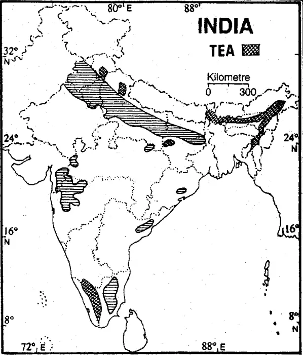
Question 7. What are the areas of production of tea in India?
Answer:

Areas of production of tea in India

India has the world’s largest area under tea cultivation and it produces 28.3 per cent of the total world production. At present, India ranks third among tea-exporting countries in the world after Sri Lanka and China.

1. Assam: Assam is the largest producer of tea contributing 53.2 per cent of the total area. In Assam, there are two main areas of tea production:
(1)The Brahmaputra valley and
(2)The Surna valley.

WBBSE Class 10 Geography Solutions

2. West Bengal: West Bengal is the second largest producer of tea in the country. Here tea is grown in
(1)The Duars, and
(2)The Darjeeling Hills.

3. Tamil Nadu: Tamil Nadu accounts for 19.90 per cent of the total production of tea in the country. Nilgiris district is the foremost producer. Other producers include Coimbatore, Kanyakumari, Madurai, etc.

4. Kerala: Kerala is the fourth largest producer of tea in India. The important producers include Kottayam, Kollam, Thiruvanthapuram, Trissur, Palakkad, Kozhikode and Kannur districts.

5. Others: Other minor producers of tea include Ratnagiri, Satara (Maharashtra); Purnea (Bihar); Hazaribagh and Ranchi Jharkhand); Almora and Garhwal districts (Uttarakhand); Kangra Valley (Himachal Pradesh); Mysore, Coorg, Shimoga (Karnataka); Tripura and Arunachal Pradesh.

WBBSE Solutions For Class 10 Geography And Environment India - Agriculture Of India Area of production of tea in india

Question 8. What are the areas of production of rice in India?
Answer:

Areas of production:
India is the second largest producer of rice in the world (after China) and its annual production amounted to over 13 crore tons. The country occupies about 28% of the world’s cultivation area under rice. Rice is cultivated in India where facilities of water are available. Rainfall of over 100 cm marks the boundary of rice-producing areas. The most important rice-producing areas of India are the Eastern Ganga Plains, the Brahmaputra valley and the narrow coastal strips forming major parts of Mahanadi, Godavari, Krishna and Kaveri deltas.

The main rice-producing states are
1. West Bengal,
2. Andhra Pradesh,
3. Uttar Pradesh including Uttaranchal,
4. Orissa,
5. Tamil Nadu and
6. Punjab.

1. West Bengal: West Bengal ranks leading position accounting for about 15% of the country’s total production. The major rice-producing districts are Vardhman, Medinipur, N & S 24-Parganas.
2. Andhra Pradesh: It ranks second in the production of rice in India. The Guntur, Kurnool and Nellore districts are leading producers.
3. Uttar Pradesh: It occupies the third position in rice production. The important rice-producing districts of the U.P. are Bahraich, Pilibhit and Kheri. Rice is also grown well in the Doon Valley of U.P.

WBBSE Solutions For Class 10 Geography And Environment India - Agriculture Of India Area of production of Rice in india
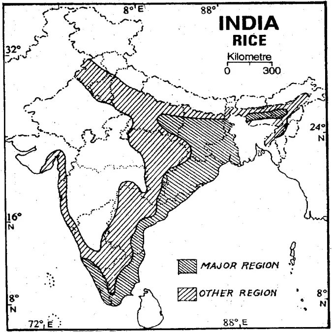
4. Tamil Nadu: It ranks fourth position in rice production in India. The Kaveri delta produces plenty of rice. The important rice-producing districts are Chennai, Madurai, Coimbatore and Thiruchirapalli.
5. Bihar: It occupies the fifth position in rice production. Darbhanga and Purnea are the important rice-producing districts of Bihar.
6. Others: Other rice-producing states are — Orissa, Punjab, Haryana, Assam, M.P., Kerala and Gujarat.

Question 9. Describe the wheat-producing regions of India.
Answer:

The main areas of wheat production in India are

(1)Uttar Pradesh,
(2)Punjab,
(3)Haryana and
(4)Madhya Pradesh.

(1)Uttar Pradesh: It is the largest producer of wheat, accounting for over 34 per cent of the country’s production. It has the largest area under wheat cultivation. It is grown in almost every part of the state, but the greatest concentration is in the western part. The important districts are Meerut, Saharanpur, Bulandshahar, Aligarh, Agra, Muzzaffarnagar, Kanpur and Mathura.

(2)Punjab ranks second (accounting for about 20 per cent of the total) in wheat production in India. The important wheat-producing districts are Ferozpur, Ludhiana, Patiala and Amritsar.
(3)Haryana occupies third place in wheat production among the states of India. The important districts of this state are Hissar, Ambala, Jind, Rohtak and Faridabad.
(4)Madhya Pradesh ranks fourth position in wheat production. The main wheat-producing districts of M.P. are Sagar, Jabalpur, Share, Gwalior, Indore and Ujjain.

WBBSE Solutions For Class 10 Geography And Environment India - Agriculture Of India Wheat producing regions of india
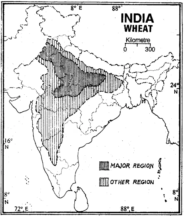
The other wheat-producing states of India are
(5)Rajasthan (Ganganagar, Kota, etc.),
(6)Bihar (Saran, Champaran, Gaya, Patna),
(7)Maharashtra,
(8)Gujarat,
(9)West Bengal,
(10)Karnataka,
(11)Jammu and Kashmir,
(12)Himachal Pradesh and
(13)Jharkhand.

Question 10. Discuss the major coffee-producing regions of India.
Answer:

Areas of Production: Coffee is produced entirely in South India. Karnataka, Kerala and Tamil Nadu are the chief coffee-producing states. Nilgiri area is the most popular coffee-producing region.

1. Karnataka: About 60% of the total area under coffee crops in India is in Karnataka state. It produces about 65% of the total coffee output in India. Most of the coffee produced here is of Robusta variety. Here the plantations are mostly confined to the South and West, particularly in the districts of Kadur, Shimoga, Hasan and Mysore. Chikmagalur district has the largest concentration of coffee area, about 35% of the country’s total coffee land. It produces about 34% of the total production.

WBBSE Solutions For Class 10 Geography And Environment India - Agriculture Of India Area of production of Coffee Producing areas in india

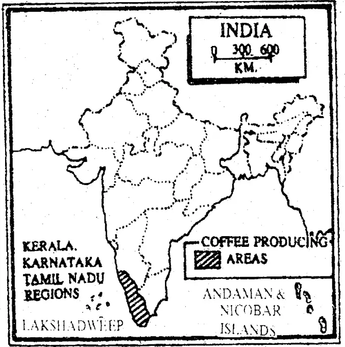
2. Kerala: Kerala is the second coffee-producing state of India. It produces about 22% of the total coffee output. In Kerala coffee is grown at an altitude of 1200 ft. It is mostly produced in the north Coorg district. Travancore, Cochin and Malabar districts are other producers.

3. Tamil Nadu: Tamil Nadu is the third largest coffee-producing state of India. It produces about 16% of the total output. In Tamil Nadu plantations are found mostly in the southwest from North Arcot to Tirunelvelli including the western areas. The Nilgiri is the most productive area, followed by the Madurai and Salem districts of Tamil Nadu.

4. Others: Some coffee is also. grown in Belgaum, Satara and Ratnagiri districts of Maharashtra. Attempts are also being made to grow coffee in areas like Araku valley of Andhra pradesh, in some parts of W.B. and Andaman Islands.

Question 11. Name the major cotton-producing areas of India.
Answer:

Areas of production: India stands in second position in the world in cotton production and ranks first in the world under cotton cultivation. About 70% of the total cotton-producing area comprises the black cotton soil area of Gujarat, Maharashtra, Madhya Pradesh, Karnataka, Andhra Pradesh and Tamil Nadu.

(1)Gujarat: It produces about 28% of the total with 25% of the total area under cotton. Ahmedabad, Mahesana, Bharuch, Kaira, Vadodra, Sabarkanta, Surat, Panchmahals, Gohilwad, and Amreli are the main producing regions.
(2)Maharashtra: It raises 18% of the crop with 30% of the total area. Important cotton-producing districts are West Khandesh, Buldhana, Akola, Yeotmal, Amravati, Wardha, Aurangabad, Adilabad, Dhulia, Jalgaon, Nagpur, Prahatni and Bhir.

WBBSE Solutions For Class 10 Geography And Environment India - Agriculture Of India cotton producing areas of india

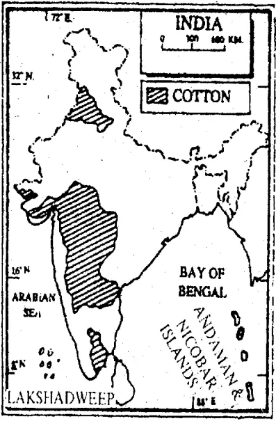
(3)Madhya Pradesh: It contains 9% of the area and provides about 3% of the production. The principal cotton-producing districts are Indore, Ujjain, Ratlam, Bhopal, Raipur, etc.
(4)Tamil Nadu: It raises 7% of the crop with 4% of the total area. Principal cotton-producing districts are Tiruchirapalli, Tirunelvelli, etc.

(5)Karnataka: It has 13% of the area and provides about 11% of the production. Bellary, Hasan, Bijapur, Mysore, Raichur, etc. are the main cotton-producing districts.
(6)Andhra Pradesh: It produces about 6% of the total with about 5% of the area.
(7)Punjab: It contributes about 16% of the total, with about 6% of the total area. Patiala, Ludhiana, Gurdaspur, Sangrur, Ferozpur, Ambala, Hoshiarpur and Bhatinda are the principal cotton-producing districts.

Question 12. Suggest how agriculture can be improved in India.
Answer:

Agriculture can be improved in the following ways :

(1)Scientific soil improvement: Scientific soil Management can increase agricultural production.
(2)Use of machines, especially tractor, etc. wherever necessary: Use of machinery, “especially tractors,” harvest threshers, etc. can increase the amount of production.

(3)Supply of good seeds: Ordinary seeds can not yield huge production. But HYV seeds like Hira, Moti, Culture-16, Culture-64, Jaya, Padma, IR-8, IR-16, MCU-5, MCH-6,etc. can produce more crops per hectares.
(4)Scientific water management: Irrigation and drainage system should be managed scientifically where rainfall is not sufficient or is in excess.

(5)Supply of fertilizer and pesticides: These can increase the production per hectare. The use of chemical fertilizers and pesticides can increase agricultural production.
(6)Agricultural knowledge: Cultivators should be given proper training in this connection. Arrangements should be made for the supply of educated labour, means of transport, marketing and selling of the crops at good rates.

Question 13. What are the physical conditions required for the production of rice?
Answer:

Rice is primarily a crop in the Tropics and Subtropics. It requires the following physical conditions for its growth:

1. Climatic conditions: Rice is a crop of the Tropical Monsoon land. It requires a hot and humid climate.

(1)Temperature: It needs a temperature of over 16°C to 20°C for its cultivation. The temperature must be higher during the growing season. It thrives well in plenty of bright sunshine with an average temperature of 27°C and water.
(2)Rainfall: Rice requires abundant rainfall, ranging from 150 cm to 200. cm. Plant of water is necessary at the time of early growth and transplantation. Water should remain standing on the ground up to 5 cm to 10 cm in the rice field in the earlier part of its growing season.

2. Land: Rice requires flooded fields. Extensive plains and lowlands provide excellent conditions for paddy cultivation. On hills and mountains, rice is grown on terraces.
3. Soil: Rice grows on a wide variety of soils, but alluvial loam with subsoils of clay is ideal. Level lands with alluvial soils of the river valleys and deltas are ideal for rice cultivation.
4. Agricultural labour: Rice cultivation requires cheap and abundant labour, as most of the work in rice fields, such as sowing, transplanting and harvesting are done by hand.

5. Other requirements: The other requirements of rice cultivation include
(1)Chemical fertilizer,
(2)Irrigation,
(3)Seeds,
(4)H.Y.V. seeds and
(5)capital.

Question 14. What are the favourable factors for the cultivation of Wheat in India?
Answer:

Wheat requires the following geographical and economic conditions for its growth:

Favourable Geographical Conditions:
1. Climate: Wheat is a crop in a temperate zone. Wheat requires a moderately cool climate with moderate rain. It is a Rabi crop and can be successfully cultivated in temperate climatic conditions of India.

(1)Temperature: The optimum temperature for wheat during its growing period is around 15.5°C. The weather should be warm and moist during the early stages of growth and sunny and dry in the later stages and during the harvest.
(2)Frost-free period: A frost-free period of 100 days is usually required.
(3)Foggy weather: Long gloomy or foggy weather is harmful to plant growth.

2. Soils: The best soil for wheat is either light clayey or heavy loam. Actually, the world’s best wheat comes from the Chernozem soils in the ‘Black Earth’ region of Ukraine.
3. Land: Slightly rolling plains are suitable for wheat cultivation. Plains should be well-drained so that water cannot stand there.

Favourable Economic Conditions:
1. Irrigation: Wheat can also be cultivated in areas of less than 50 cm of rainfall by practising irrigation or dry farming methods.
2. High Yielding Variety: The uses of HYV of seeds like Larma-Rajo, Sonera-63, Sonera-64, Sona-227, and Sonalika-308 have promoted the average yield per hectare.
3. Labour: Labour factor is not as important in wheat cultivation as in the case of rice.

4. Other requirements:
(1)Adaptation of scientific methods,
(2)Introduction of farm machinery like tractors, harvesters, winnowers, threshers, elevators, etc.
(3)Improvement in transport,
(4)Financial capital, etc. are the other requirements of wheat cultivation.

Question 15. Explain the major characteristics of Indian agriculture.
Answer:

The major characteristics of Indian agriculture

1. Subsistence agriculture: Most parts of India have subsistence agriculture. The farmer owns a small piece of land, grows crops with the help of his family members and consumes almost the entire production with little surplus to sell in the market.
2. Pressure on population: The population in India is increasing at a rapid pace and exerts heavy pressure on agriculture. Agriculture has to provide employment to a large workforce and also feed the teeming millions.

3. Pre-dominance of animal force: Animal force plays an important role in ploughing irrigation, threshing and transporting agricultural products. Complete mechanisation of Indian agriculture is still a distant goal.
4. Uses of irrigation: Indian agriculture is mainly dependent upon monsoon, which is uncertain, unreliable and irregular. In spite of the large-scale expansion of irrigation facilities since independence, only 1/3 of the cropped area is provided by perennial irrigation.

5. Small size of land holdings: Laws of inheritance of property have caused fragmentation of large land holdings. This causes a loss of cultivable land and reduces production significantly.
6. Uncontrolled use of pesticides and chemical fertilisers: The use of chemical fertilisers initially boosts agricultural produce, but damages the soil in the long run. Uncontrolled use of pesticides also affects fertility and reduces production.

7. Predominance of food crops: Since Indian agriculture has to feed a large population, the production of food crops is the first priority. More than 2/3 of the total cropped area is devoted to the cultivation of food crops.
8. Insignificant place given to fodder crops: Although India has the largest population of livestock in the world, fodder crops are given a very insignificant place in the crop calendar. Only 4% of the land is under permanent pastures. This is due to the tremendous need for food grains. The result is that domestic animals are not properly fed and their productivity is low.

9. Variety of food crops: India is a vast country with a variety of relief, climate and soil conditions. Therefore, a large variety of crops are grown all over the country depending upon suitable conditions.
10. Dependence on monsoon: Indian agriculture is highly dependent on monsoon rains. The choice of crops in areas is directed by the availability of rainfall in those regions, e.g. water-loving crops like rice, jute, etc. are cultivated in eastern India, while millets are cultivated in the dry western regions. But irregular and uncertain nature of the monsoon rains often results in crop failure.

Question 16. Divide and explain crops on the basis of season.
Answer: In India, different crops are sown in different seasons. There are two major crop seasons in India:

1. Kharif: The Kharif crops are associated with the South-west Monsoon. They are sown in the months of June and July and harvested in the autumn months, ie., in September and October. Important Kharif crops are rice, jawar, bajra, ragi, maize, sugarcane, cotton and jute.

2. Rabi: The rabi season begins with the onset of winter in October-November and ends in March-April. The low temperature conditions during this season help the cultivation of temperate and subtropical crops like wheat, barley, peas, linseed, rapeseed, gram and mustard. Besides the Kharif and Rabi crops, there are certain crops which are raised throughout the year. They are known as ‘Zaid’.

They include:
1. Zaid Kharif Crops: These are sown in August and September and harvested in December and January. Most oilseeds like mustard are grown in this season.
2. Zaid Rabi Crops: These crops are sown at the beginning of the hot season in February and March and are harvested in the month of April and Mey. Summer vegetables, jowar, maize, watermelons, cucumbers, etc. are important among these crops.

Question 17. Classify and explain crops on the basis of nature.
Answer:

Crops can be classified on the basis of their nature as:

1. Food crops: The plants that are grown with the primary purpose of being consumed or éaten by humans and animals, e.g. rice, wheat, millets, pulses, oilseeds, etc.
2. Fibre crops: These crops are grown for their fibres which are used to make paper, cloth or rope, e.g. cotton, jute, mesta, etc.

3. Plantation crops: A plantation crop is one crop which is specifically planted in a large piece of land (a plantation) in tropical or semi-tropical areas and grown on a commercial basis. E.g. tea, coffee, rubber etc.
4. Cash crops: A crop produced for its commercial value rather than for use by the grower, E.g tea, coffee, etc.

5. Others: Among other crops, there are forage crops (food for animals) like sorghum, elephant grass, etc.; root crops like sweet potato, sugarcane, sugarbeet, turnip, etc.; tuber crops like potato, yam, etc.; sugar crops like sugarcane, sugarbeet; drug crops like tobacco, mint, etc.; spices like ginger, garlic, chili, cumin, onion, coriander, turmeric, etc.; vegetable crops like brinjal, tomato, etc.; aromatic crops like lemongrass, palmarosa, rose, jasmine, henna, etc.

“Class 10 WBBSE Geography Agriculture of India important questions”

Question 18. What are the problems of wheat production in India?
Answer:

Problems of wheat production in India

It is practically true that the hectarage of wheat production in India has much improved today but in the world, there are countries enjoying much greater hectarage. Besides, in India rice is more popular than wheat firstly as a food crop and secondly as a commercial crop.

The constant problems are as follows:
1. Comparatively Low YPH: Wheat production in India per hectare is 2510 kg, whereas, in Germany, it is 7,283 kg, in France, 6,632 kg, in China, 4,087 kg, and in Ukraine the hectarage is 3,137 kg.

2. Lack of Desired Popularity: Wheat production in India suffers from limitations because as a foodgrain it is less popular than Rice (a staple food in India). India is self-sufficient in wheat production today, nevertheless, statistically rice occupies the crown, forin 1996-97 India produced 813.14 lakh tonnes of rice (from 432.83 lakh hectares of and-area) whereas (from 259.34 lakh hectares of land-area) the result of wheat-culture was 692.75 lakh tonnes.

3. Limited Area of Production: As a whole, most of the fertile agricultural land in India is climatologically ready for the culture of Kharif crops, so rice enjoys a comparatively larger area. But, wheat is a Rabi crop and holds much less portion of cultivated area in the country. In 1996-97 total land area devoted to wheat cultivation was 259.34 lakh hectares, whereas rice cultivation it was 432.83 lakh hectares.

4. Concentration of Culture in North-West India: The largest wheat area is found in and around the Ganga-Sutlej Plains in India. The key states are U.P., Punjab, Rajasthan, Haryana and the north-western parts of M.P. This is because of the favourable geographical conditions of the growth of wheat prevailing in the above area. On the contrary, peninsular India does not offer all such favours for wheat cultivation. Barring Andhra Pradesh, south India is not important for wheat culture. The production over here is meagre.

5. Decreasing Productivity of Soil: Wheat is predominantly a crop grown over the arid or semi-arid zones in India. Though it is a Rabi crop, irrigation is a must for its cultivation especially when there are
1. Use of HYV seed,
2. Double cropping,
3. Useof chemical fertilizers. Much use of irrigation results in an increase in the amount of salt in the soil and a decrease in productivity. Wheat fields of Punjab, Haryana and Rajasthan are thoroughly irrigated and so excess salt is retained in the soils.

6. Increase in the Price of Fertilizers and Insecticides: At the present time, the price of chemical fertilizers and insecticides has risen too high to remain within the purchasing capacity of the farmers. This leads to the farmers’ discouragement that is hampering wheat production to a large extent. Agricultural loans through the Credit Cell of the Government are assisting the farmers remarkably but this does not reach the satisfactory goal.

7. Backwardness of the Farmers in India: In spite of the implementation of modernity and various facilities towards wheat cultivation and cultivators, the improvement of the hectarage and the impetus behind it proved fruitless. Otherwise, Indian hectarage of wheat could compete with that of China or France.

The main reason behind this is the backwardness of the farmers in India, which can be parted out into two socio-economic menaces eroding rural India:
1. Poverty and
2. ignorance HYV seeds of wheat have been introduced. The success of HYV depends upon the input of recommended dosages. But due to poverty and ignorance, cultivators became unable to use the dosage properly.

Question 19. Suggest some measures to fight the problems of wheat cultivation in India.
Answer:

Measures to Fight the problems of Wheat Cultivation: In order to fight the problems of wheat cultivation in India, some steps have already been taken and some have been recommended. They are pointed out as follows :

1. The Indian Council of Agricultural Research is working in full cry to work out the correct measures for solving the problems of wheat cultivation in India.
2. HYV seeds of wheat have been introduced.
3. Lands utilized for inferior-quality food crops are being used as wheat-producing areas. Thus wheat is gradually becoming as popular as rice.
4. Irrigation network is becoming more extensive and for this new canals are built and new dams and barrages are constructed under new river-based projects.
5. More land area is being utilized for double cropping of wheat.
6. Special importance is being given to more utilization of chemical fertilizers.
7. Wheatlands of eastern India and the Indian Peninsular region are now under special consideration. Besides, in North-West India, the Government is now serious to enhance the hectarage of wheat as also in other once neglected wheatlands of India.
8. Frequent light irrigations, correctly timed irrigations, and the use of gypsum on sodic soils for conversion are some of the methods being applied in order to eradicate the salinity of wheat soil.

Question 20. Mention the favourable factors for the cultivation of millets.
Answer:

Favourable factors for the cultivation of millets:

Areas not suitable for the cultivation of rice or wheat are devoted to millet.

1. Climatic conditions: |t is widely grown in tropical countries like India.

Temperature:It needs a temperature between 25°-32°C for its growth.

Rainfall: It is a hardy crop. So, rainfall between 40 cm—75 cm is good for its growth.

2. Land: Flat or undulating land is suitable for its cultivation.
3. Soil: It can grow on less fertile. soil ranging from-dry alluvium to infertile red soil.
4. Agricultural labour: Cheap labour is required during sowing and harvesting periods.

5. Other requirements:
1. Irrigation: It grows in large amounts in well-irrigated lands.
2. High yielding variety of seeds like CSH 5 and 6 for jowar and BJ104, and BK560 are required for growing them well.
3. Fertiliser,
4. Capital,
5. Port and
6. Market are also another requirement of the crop.

Question 21. What are the favourable factors for sugarcane cultivation?
Answer:

The favourable factors for the cultivation of sugarcane are:

1. Physical conditions:
Temperature:
Sugarcane matures in 10 to 18 months depending on the climate. Sugarcane grows best in areas with 20°C to 26°C temperatures. Its growth starts at a mean temperature of about 20°C and the growth accelerates with an increase in temperature up to 24°C and finally stops at 26°C. Frost is fatal for sugarcane crops. A short cool dry winter season during ripening and harvesting is ideal.

Rainfall: Sugarcane grows well in tropical regions with 100-150 cm of rainfall well-distributed throughout the year. However, irrigation is necessary in areas of lower rainfall or even in areas of higher rainfall during long dry spells. The sucrose content decreases if heavy rains continue for a long and a rainfall deficiency produces a fibrous crop. A slightly dry sunny weather is necessary during the ripening stage of the cane.

Soil: Sugarcane and clayey loams of the Great Plains and on black soils, brown or reddish loams and laterites in Peninsular India. Sugarcane exhausts the fertility of the soil. Hence, the soil is supplemented with manures and nitrogenous fertilizers.

Favourable economic conditions:
Labour:
It is a labour-intensive method of cultivation. Weeding, manuring, field preparation, planting and harvesting have to be done by hand.

Capital: A large capital is needed invariably to grow this plantation crop.
Fertilisers: It is a soil-exhausting crop. Hence good fertilisers are required.

Other requirements:
1. Well developed transport network is necessary for its quick transport from fields to the factory (refinery). The juice extracted from the plant dries up easily and its sugar content decreases if it is not extracted within a day (24 hours).
2. Fertiliser,
3. Port and
4. Market are another important factor.

Question 22. State the favourable factors for the growth of tea in India.
Answer:

Tea requires the following favourable geographical and economic conditions for growth:

Favourable Geographical Conditions:
1. Climate:
Tea is a sub-tropical plant and needs a hot and wet climate.
Temperature: Tea requires temperatures between 10°C and 35°C. The growth is retarded if it falls below 18°C. The most suitable temperature for tea growth 25°C.
Rainfall: The tea plant needs rainfall varying between 150 cm and 200 cm. The rainfall should be well-distributed throughout the year. It cannot withstand long spells .of dry weather at any season of the year.
Humidity: High humidity, heavy dews and morning fog favour the rapid development of young leaves.
Winter frost: Widespread winter frost is harmful to the crop.
Shade: Tea is a shade-loving plant and develops more vigorously under light shade. Shade plants are generally grown in tea gardens to avoid direct sunshine on tea.

2. Relief: Almost all the commercially-managed tea plantations are located in highlands and on hill slopes where the natural. drainage is good. Tea cannot tolerate stagnant water and thus waterlogged lowland areas are least suited to tea cultivation.

3. Soils: Tea requires well-drained sandy loam with porous subsoil. The sandy loam is considered the best soil for tea cultivation. The soil must be deep and have a moderately open texture. Virgin forest soils, containing a good deal of iron and humus, are ideal for tea cultivation.

Favourable Economic Conditions:
1. Labour:
Tea cultivation and processing are labour-intensive. The work of field preparation, weeding, manuring, pruning and picking goes on all year round on the tea estates. Tea plucking requires an abundant supply of cheap labour. Female labour is preferred for tea picking because it is a tedious job, requiring both skill and patience. Plucking demands a skilled manipulation of fingers, as with care, two leaves and bud are to be plucked out at a time.

2. Capital: Tea is very capital-intensive cultivation. Tea estate requires a heavy amount of capital.
3. Fertilizer: Tea is an exhausting crop, and as such, requires manuring of the soil.

Question 23. Account for the agricultural prosperity of Punjab & Haryana.
Answer:

Punjab and Haryana are two of the 29 states of India located in the North-Western part of India, roughly between 27°N-32°N and 73°E-77°E. The states are situated on the fertile alluvial plain which is arable and is irrigated by submersible pumps and an extensive canal system. Punjab and Haryana contributed heavily to the green revolution that made India self-sufficient in food production in the 1960s. In 1961 India was on the verge of mass famine.

Norman Borlaug, the father of the Green Revolution in the world, was invited to India to tackle the situation and take initiative to increase agricultural crop production. Punjab and later Haryana were selected as the sites to try new crops because of their reliable water supply. India thus began the Green Revolution which led to the agricultural prosperity of Punjab and Haryana.

The measures adopted in Green Revolution were:
1. Use of High Yielding Variety (HYV) seeds,
2. Irrigation,
3. Use of insecticides and pesticides,
4. Consolidation of holdings,
5. Land reforms,
6. Transforming single cropping land to multiple cropping land,
7. Introduction of modern agricultural implements and machinery,
8. Use of sprinklers or drop irrigation technique,
9. Use of quality manure and chemical fertilisers,
10. Supply of agricultural credit, and
11. Educational programmes for agriculture under ICAR (Indian Council of Agricultural Research), etc. The spectacular rise in the production of cereals, particularly wheat, ushered in a new era of agricultural prosperity in these states. Due to this our country also became self-sufficient in foodgrain production.

Import of food grains. has been reduced and through the export of grains India is earning foreign production. With the development of agriculture, many agro-based industries have been set up in these states which provide employment to a large number of people, leading to the prosperity of the farmers.

Question 24. State the problems of rice cultivation with their solutions.
Answer:

Rice production in India has many problems:

1. Rice yield per hectare is low. So high-yielding varieties of seed, fertilizers, insecticides, etc. should be introduced to increase rice yields per hectare.
2. Farmers do not get a suitable price for their rice production as middlemen buy it cheaply from them at harvest time and sell it at a higher price making profits themselves. Thus, cooperatives should be set up, procurement prices should be prefixed by the Govt.’s Food Corporation. They should come forward to sell the rice in the market so that the profits are enjoyed by the farmers.
3. Proper storage facility of rice is not available. Unless more storage facilities are created, high production would be pointless as they would be damaged while being improperly stored.
4. Proper distribution of land needs to be undertaken as rice cultivation is mainly done by landless labourers and not by the land owners. So proper attention to cultivation is not given.

Question 25. State some problems of the Green Revolution.
Answer:

Problems of Green Revolution: The Green Revolution has been a unique event in the agricultural history of independent India, as it has saved the country from the disasters of hunger, and starvation and also made Indian peasants more confident than ever before. But it has its own inherent deficiency segments.

Ever since its inception, the income gap between large, marginal and small farmers has increased; the gap between irrigated and rain-fed areas has widened and some crops have benefited more than others, even at the cost of other crops. This has also given birth to a plethora of socioeconomic problems.

The spiralling prices of fertilizers, the tendency to use them frequently and the stagnant wheat and rice yields in Punjab and Haryana have combined to confirm that Green Revolution has reached an old age. The fatigue of the Green Revolution is also.

visible: Some of the problems of the Green Revolution are:
1. Inter-Crop Imbalances: The effect of the Green Revolution primarily has been felt on foodgrains including wheat, rice, jawar, bajra, and maize and the production of these crops has gone high. But it has wrested areas from coarse cereals, pulses and oilseeds.

2. Regional Disparities: The Green Revolution technology has given birth to growing disparities in economic development at inter-regional and intra-regional levels. It has so far affected only 40% of the total cropped area and 60% is still untouched by it. The most affected areas are Punjab, Haryana, Western Uttar Pradesh, A.P., and Tamil Nadu in the south but it has hardly touched the eastern region including Assam, Bihar, West Bengal, Orissa and arid and semi-arid regions. The green revolution also affected to only areas which were already better from an agricultural point of view.

3. Unemployment: Except in Punjab and Haryana farm mechanization under Green Revolution has created widespread unemployment among agricultural labourers in the rural areas and the worst hit are the poor and landless people.

4. Other Related Problems: Agriculture under Green Revolution has not grown at the rate which was expected in the beginning. The high-yielding variety seeds are also responsive to certain key inputs such as fertilizers, and irrigation; as a result, there is also an increase in the cost of production. Some experts have also commented that the indigenous varieties could also be high yielding under required doses of inputs.

Some experts have also blamed the green revolution for destroying natural mechanisms for controlling pests though due to the loss of diversity the miracle seeds of the green revolution have become a mechanism for breeding new pests and creating new diseases.

The excessive use of groundwater for proceeding irrigation to high-yielding variety seeds has also led to large-scale depletion of groundwater and the use of chemical fertilizers and pesticides has severely affected the health of the soil.

Though the green revolution did increase food grain production in the country it has been achieved at the cost of intensive use of irrigation water, fertilizers and other inputs. This has resulted in problems of soil salinization, groundwater pollution, nutrient imbalances, the emergence of new pests, diseases and environmental degradation.

This has also given the problem of regional inequality to the matter of income and production and only the western and some southern part of the country have got the maximum benefit of the green revolution. The green revolution has only benefited some big enterprising farmers whereas the majority of the marginal and small farmers are deprived of benefits. Thus, the overall. impacts of green revolution have failed to influence the agricultural sector.

“WBBSE Geography and Environment Agriculture of India solutions PDF”

Considering all these facts the pioneer of the Indian Green Revolution, Mr M. S. Swaminathan, presently chairman of the National Commission on Farmers, also gave a new call for another green revolution for doubling the present production level of food grains. For making it a success, he stressed on adopting the best scientific techniques and promoting organic farming.

The government has also given urgent attention to initiating another green revolution. The approach paper to Eleventh Plan has aptly highlighted such a holistic framework and suggested the following strategy to raise agricultural output. Such as-

1. Doubling the rate of growth of irrigated areas.
2. Improving water management, rainwater harvesting, and watershed development.
3. Reclaiming degraded land and focusing on soil quality.
4. Diversifying agricultural productivity into high-value outputs such as fruits, vegetables, flowers, herbs, spices, medicinal plants, and biodiesel but with adequate measures of food security.
5. Promoting animal husbandry and fishery.
6. Providing easy access to credit at affordable rates.
7. Improving the incentive structure and functioning of markets and refocusing on land reform issues.

Thus, the approach to the second green revolution seems to aim at the efficient use of resources and conservation of soil, water and ecology on a sustainable basis and in a holistic framework.

WBBSE Solutions For Class 10 Geography And Environment Chapter 3 Hydrosphere

Class 10 Geography West Bengal Board Chapter 3 Hydrosphere True Or False Type:

Question 1. Floods occur in India during the years of El Nino.
Answer: False

Question 2. The position of the sun, moon and earth along a straight line is known as syzygy.
Answer: True

Question 3. The salinity of seawater is maximum in the Equatorial region.
Answer: False

Read and learn all WBBSE Solutions For Class 10 Geography And Environment

Question 4. Change of seasons is observed in the Equatorial region.
Answer: False

Question 5. The drought conditions develop in the western coast of South America due to the influence of El Nino in the Pacific Ocean.
Answer: False

“WBBSE Solutions for Class 10 Geography Chapter 3 Hydrosphere”

Question 6. ‘Chinook is an example of seasonal wind.
Answer: False

Question 7. Kuro Shio current flows near the coast of China & Japan.
Answer: True

Geography Class 10 West Bengal Board

Question 8. Flumbolt current flows along the West Coast of South America.
Answer: True

Question 9. Gulf Stream flows towards the North through the Gulf of Mexico.
Answer: True

Question 10. Guinea current flows towards the West Africa Coast.
Answer: True

Question 11. The Sargasso Sea is situated at the middle of the North Atlantic Ocean.
Answer: True

Question 12. Labrador is a cold current from the Arctic Ocean.
Answer: True

Question 13. Venezuela currently flows near the coast of South-West Africa.
Answer: True

Question 14. Peru is a cold current of the Pacific Ocean.
Answer: True

Question 15. Madagascar current flows along the East coast of Madagascar Island.
Answer: True

Question 16. Mozambique current is a warm current.
Answer: True

Question 17. Madagascar and Mozambique currents unite together to form Agulhas current.
Answer: True

Question 18. The wind is responsible for the origin of ocean current
Answer: True

Question 19. Brazilian Current occurs in the Atlantic Ocean.
Answer: True

Question 20. The shape of the coastline exerts some influence in the direction of the currents.
Answer: True

Question 21. Benguela current is found on the South Eastern coast of Africa.
Answer: False

Question 22. The planetary winds play a major role in the formation of ocean currents.
Answer: True

Question 23. Monsoon wind is an example of local wind.
Answer: False

Question 24. The polar region has a low-pressure belt.
Answer: False

Geography Class 10 West Bengal Board

Question 25. Tropical cyclone causes disasters.
Answer: True

Question 26. The stratosphere is the lowest layer of the atmosphere above the earth’s crust.
Answer: False

Question 27. In the confluence of warm and cold currents fishes are abundant.
Answer: True

Question 28. A Humboldt current is a warm current.
Answer: False

Chapter 3 Hydrosphere Fill in The Blanks Type:

Question 1. With the increase of air pressure gradient, wind velocity ______.
Answer: Increase.

Question 2. The cold ocean water from the polar region flows as ______ current towards equator.
Answer: Under Current.

Question 3. ______current causes snowfall in New Foundland.
Answer: Labrador.

Question 4. During high tide huge tidal waves entering through the mouth of a river from the sea are called ______
Answer: Tidal bore.

Question 5. ______ force of the earth causes secondary high tide.
Answer: Centrifugal.

Question 6. Air conditioners emit ______ gas into the atmosphere.
Answer: CFC.

Question 7. Pull of the ______ is responsible for tides.
Answer: Moon.

Question 8. The Sargasso Sea is found in the ______ ocean.
Answer: Atlantic.

Question 9. Tidal bores are common in the ______ river of China & Hooghly in India.
Answer: Yangtze Kiang.

Question 10. The interval between two high tides is ______.
Answer: 12 hrs 26 m.

Question 11. ______ tides are caused by the gravitational pull of the sun &the moon.
Answer: Spring/High.

Question 12. Tides occurring at the opposite side of the spring tide are called ______ tides.
Answer: Secondary.

Question 13. Alternate rise and fall of sea water are called _______.
Answer: Tides.

Question 14. Primary tides are also known as ______ tides.
Answer: Direct.

Question 15. Tides make rivers ______.
Answer: Navigable.

Question 16. The interval between high trades and low tides is ______.
Answer: 5 hrs 13 ms.

Question 17. Warm currents keep the coastal areas ______.
Answer: Warm.

Question 18. Cool currents keep the coastal areas ______.
Answer: Cool.

Question 19. Labrador is a cold current of the ______.
Answer: Atlantic ocean.

Question 20. ______ flows along the southwest coast of South America.
Answer: Humboldt current.

“Class 10 Geography and Environment Hydrosphere solutions WBBSE”

Question 21. Grand Bank is famous for ______.
Answer: Commercial fishing.

Question 22. North Indian ocean currents are dominated by ______.
Answer: Monsoon wind.

Question 23. ______ is responsible for the origin of ocean currents.
Answer: Prevailing winds.

Question 24. Ocean currents deflect due to the movement of the earth’s gravitational.
Answer: Rotational.

WBBSE Solutions For Class 10 Geography And Environment Chapter 3 Hydrosphere

Geography Class 10 West Bengal Board Chapter 3 Hydrosphere Very Short Answer Type:

Question 1. Name the southernmost mountain pass of the Western Ghats.
Answer: Palghatgap

Question 2. What is the local name of the lagoons in the Kerala coast?
Answer: Koyal

Question 3. On which quarters of the moon, does Neap tide occur?
Answer: Dark and White Half of a lunar month.

Question 4. What is the main food of marine fish?
Answer: Planktons.

Question 5. What type of current originates in the tropical oceans?
Answer: Warm Current

Question 6. What is the time interval between two primary high tides and two secondary high tides?
Answer: 24 hrs 52 mins.

“WBBSE Class 10 Geography Chapter 3 solved questions”

Question 7. What is the time interval between two low tides?
Answer: 12 hrs 26 mins.

Geography Class 10 West Bengal Board

Question 8. What is drift?
Answer: If the mass of water moving on the surface of an ocean is broad, slow and shallow, it is termed as drift.

Question 9. What is Tide?
Answer: The alternative rise and fall of seawater is called Tide.

Question 10. Name three forms of movement of oceanic water.
Answer: Waves, currents, and tides.

Class 10 Maths Class 10 Social Science
Class 10 English Class 10 Maths
Class 10 Geography Class 10 Geography MCQs
Class 10 History Class 10 History MCQs
Class 10 Life Science Class 10 Science VSAQS
Class 10 Physical Science Class 10 Science SAQs

Question 11. Give one term for each of the following statements:
1. The time taken by two consecutive crests to pass any fixed point.
2. Vertical distance between a trough and a crest of a wave.
3. An oscillatory movement in a body of water manifested by an alternate rise and fall of the surface.
4. The breaking waves in a coastal region.
5. Currents flow from low latitudes to higher ones.
6. A vertical wall of tidal waters moving upstream in the river channel.

Answer:
1. Wave period.
2. Wave height.
3. Ocean wave.
4. Surf.
5. Warm currents.
6. Tidal bore.

Question 12. Name three types of waves generated by wind.
Answer: Sea, Swell and Surf.

Question 13. What are the different types of currents?
Answer: Warm currents and cold currents.

Class 10 Geography West Bengal Board

Question 14. What are warm currents?
Answer: Warm Currents: Currents flowing from equatorial regions to polar regions on the surface of the oceans due to their lightness.

Question 15. What are cold currents?
Answer: Cold Currents: Currents flow from polar regions to equatorial regions under the surface of the oceans due to the cold water being heavy.

Question 16. Why are oceans and seas often called inner space?
Answer: Oceans and seas are sometimes called ‘inner space’ because the space occupied by them is covered with water.

Question 17. What do you mean by ‘Sargasso Sea’?
Answer: Sargasso Sea is stagnant water where seaweeds grow and accumulate and it is found in the North Atlantic and North Pacific Oceans.

Question 18. In which ocean ‘the Cold Wall’ is found?
Answer: ‘The Cold Wallis is found in the Atlantic Ocean.

Question 19. Name the deepest lake in the world.
Answer: Lake Baikal is the deepest lake (1620 m) in the world.

Geography Class 10 West Bengal Board

Question 20. How much is the gap of time between the two primary tides?
Answer: The gap of time between the two primary tides is 24 hours and 52 minutes.

Question 21. What is an iceberg?
Answer: An iceberg is a broken mass of ice from a coastal glacier floating in the ocean.

Question 22. Which ocean current keeps the coastline of Japan warm?
Answer: The warm Kuroshio Current keeps the Japanese coast warm.

Question 23. Which one is the largest lake in the world?
Answer: The Caspian Sea (4,38,700 sq. km) is the largest lake in the world.

Question 24. Name the saltiest lake in the world.
Answer: Dead sea is the saltiest lake in the world; even fish cannot live in it.

Question 25. What do you know about evaporation regarding ocean currents?
Answer: Evaporation: More evaporation reduces the amount of water and lowers its level. In order to maintain the balance, water from other areas starts flowing in the form of a current.

Question 26. What is ocean current and how does it differ from the wave?
Answer: The regular movements of water from one part of the ocean to another are called ocean currents. They differ from waves. The waves are the movements of surface water of the ocean and sea with only rise and fall of the water surface and there is no onward motion as in ocean current.

Question 27. Mention one cause of ocean currents.
Answer: Planetary wind.

Question 28. Where do you find the Sargasso Sea?
Answer: In the North Atlantic Ocean.

Question 29. In which sea the salinity is maximum-Baltic Sea/Mediterranean Sea?
Answer: Mediterranean Sea.

Question 30. Name the longest lake in the world.
Answer: Lake Tanganayika.

Question 31. What is Grand Bank?
Answer: A fishing centre near Newfoundland.

Question 32. Mention the factors affecting ocean currents.
Answer: Temperature, wind velocity, salinity and rotation of the earth.

Question 33. Name one man-made lake in India.
Answer: Govind Sagar (Himachal Pradesh).

Question 34. Name one tidal river.
Answer: The Hugli (Hooghly) river is a tidal river.

Question 35. How many times a place on the globe experiences high or low tides in a day?
Answer: A place on the earth experiences one high tide and one low tide in a day.

Question 36. How much percentage of the earth is covered with water?
Answer: 71 per cent.

Question 37. Name the deepest place in the ocean.
Answer: Mariana Trench of the Guam Islands (11,033 metres).

Question 38. How much part of the earth’s surface is covered by the Pacific ocean?
Answer: 1/3rd part.

Question 39. What percentage of the ocean floor is covered by the continental shelf?
Answer: 7.5%.

Question 40. What is the length of the Mid-Atlantic Ridge?
Answer: 14,000 km.

Question 41. Name the most common features found on the ocean floors.
Answer: Continental shelf, Continental slope, Continental rise and Abyssal Plain.

Question 42. Why is the earth known as ‘Watery Planet’?
Answer: Because 71% of its surface area is covered by water.

Question 43. Give one term for each of the following statements:
1. A gently seaward sloping surface extending between the shoreline and the continental slope.
2. A flat, nearly level area in the ocean, lying beyond the continental slope.
3. A submarine mountain or peak rising more than 1,000 metres above the ocean floor.

Answer:
1. Continental shelf.
2. Abyssal plain.
3. Seamount.

Question 44. What are the processes heating ocean water?
Answer:
1. Absorption of heat radiation from the sun.
2. Convection of heat through the ocean bottom from the interior of the earth.

Question 45. Name the processes of cooling ocean water.
Answer: Back radiation of heat, convection and evaporation.

Question 46. Name the factors affecting the temperature of ocean water.
Answer: Latitude, prevailing winds, ocean currents, adjacent land waters, salinity and icebergs.

Question 47. At what temperature the density of pure water is maximum?
Answer: At 4°C

Question 48. Name the two most important factors which affect the density of ocean water.
Answer: Temperature and salinity.

Question 49. Give one term each for the following:
1. Floating or stranded masses of ice at least five metres above the level of the sea.
2. Index of the amount of total dissolved solids in seawater.
3. Mass per unit volume of a substance.

Answer:
1. Iceberg.
2. Salinity.
3. Density.

Question 50. Name three forms of movement of oceanic water.
Answer: Waves, currents and tides.

Question 51. Give the formula for finding the velocity of a wave.
Answer:  Velocity of wave (C) = Wavelength(L)/Period(T)

Question 52. Name three types of waves generated by wind.
Answer: Sea, Swell and Surf.

Question 53. What are the different types of currents?
Answer: Warm currents and cold currents.

Question 54. When does spring tide occur?
Answer: On a full and new moon when the earth, moon and the sun are in line with the earth.

“Hydrosphere Class 10 WBBSE solutions and answers”

Question 55. When does neap tide occur?
Answer: In the first and the last quarter of the moon when the sun and the moon make a right angle at the earth’s centre. ”

Question 56. What is the time interval between two successive tides?
Answer: 12 hours and 25 minutes.

Question 57. What is a Bay?
Answer: It is a wide indentation into the land produced by the sea. E.g. Bay of Bengal.

Question 58. What are waves?
Answer: Waves are the oscillatory movements in water, manifested by an alternate rise and fall of the sea surface.

Chapter 3 Hydrosphere 2 Marks Questions And Answers:

Question 1. What do you mean by Perigean Spring tide?
Answer:

Perigean Spring tide:

A Perigean spring tide occurs when the moon is either new or full and closest to Earth. Often between 6-8 times a year, the new or full moon coincides closely in time with the perigee of the moon — the point when the moon is closest to the Earth. These occurrences are often called Perigean Spring tides.

Question 2. What is an Inter-tropical convergence zone?
Answer:

Inter-tropical convergence zone:

Inter-Tropical Convergence Zone: In the winter the Indian climate is influenced by the western disturbances originating from the Mediterranean sea and is characterised by snowfall or rainfall (its influence is seen sometimes up to the plains of West Bengal also). Kashmir, Punjab, and Western U.P. receive snowfall or rain during this time.

Question 3. State the definition of ocean current.
Answer:

ocean current:

The stream of water that flows from one place to another, regularly within the ocean itself, is called an ocean current. Ocean currents are of two types – warm currents and cold currents.

Class 10 Geography WBBSE

Question 4. What is the apogean tide?
Answer:

Apogean tide: When the moon is farthest from the earth (4,03,320 km), this position is known as Apogee. Due to the reduced attraction of the moon, the tide is also 20% less high. This is known as Apogean tide.

Question 5. What is a tidal bore?
Answer:

Tidal Bore: When a tide enters the narrow and shallow estuary of a river, the front of the tidal wave appears to be vertical, owing to the piling of water of the river against the tidal wave and friction against the river bed. The steep-nosed tide crest looks like a vertical water of water rushing upstream. This is called a Tidal Bore.

Question 6. Explain the types of ocean currents.
Answer:

Types of Currents:

Ocean currents are, in broad terms, of two types:

1. Warm currents and
2. Cold currents.

Warm Currents: Movement of ocean water from low latitudes to higher latitudes on the ocean surface.

Cold Currents: Movement of ocean water from high latitudes to low latitudes under the ocean surface.

Question 7. What is Neap tide?
Answer:

Neap tide:

When the sun, the moon and the earth are in the position of right angle, the attractions of the sun and the moon oppose each other which makes the tide weaker and this type of tide is called neap tide, This situation occurs at the first and the third quarters of the moon.

Question 8. What is SYZYGY?
Answer:

SYZYGY:

SYZYGY is a position in which the sun, the moon and the earth lie in the same straight line.

Question 9. what is the Great Barrier Reef?
Answer:

Great Barrier Reef:

Great Barrier Reef, situated in the Pacific Ocean, is the world’s largest coral reef.

Question 10. Differentiate between warm currents and cold currents.
Answer:

Difference between warm currents and cold currents

WBBSE Solutions For Class 10 Geography And Environment Chapter 3 Hydrosphere warm and cold current

Question 11. Ships prefer to sail along ocean currents. Why?
Answer:

Ships prefer to sail along ocean currents

Ships prefer to sail along the ocean currents because ships sailing down the currents surely go faster, which saves time and fuel.

Question 12. What is a tidal bore?
Answer:

Tidal bore:

When a high tidal wave in shallow water reaches the mouth of a river, it causes the water to pile up across the river and water moves along like a broken wave and advances upstream like a wall of water. This is known as a tidal bore. It occurs in the Hooghly, the Amazon, the Yang-tse-kiang, etc,

Question 13. What is the Sargasso Sea?
Answer:

Sargasso Sea:

In the Atlantic Ocean the North equatorial current, the Gulf current and the Canary current move in a circular way. In between these currents water is stagnant. Seaweeds and other elements gather here. And in these elements weeds known as ‘Sargasso’ are found. That is why the region is known as the Sargasso sea.

Question 14. What is Spring tide?
Answer:

Spring tide:

At full moon and new moon the sun and the moon are more or less in a straight line with the earth. Due to this combined pull of the sun and the moon the highest high tides are produced on the earth. These highest tides are known as ’Spring Tide1.

“WBBSE Class 10 Geography Hydrosphere chapter answers”

Question 15. Why does tidal bore occur in the Ganga?
Answer: Tidal bores occur in those rivers which have certain conditions. In the case of the Ganga (Hooghly) river, the river mouth is funnel-shaped and especially in monsoon season the river is already filled with water and so tidal bores are common, especially in the Ganga river.

Question 16. What is a ‘Cold wall’?
Answer:

‘Cold wall’:

A cold wall is a discontinuity layer between any cold and warm current, e.g. between the Labrador current and the Gulf stream.

Question 17. Name the types of movements in ocean water.
Answer:

Three types of movements in ocean waters are:

1. Waves.
2. Tides and
3. Ocean currents.

Question 18. What do you mean by ocean currents?
Answer:

Ocean currents

Regular movement of a mass of water in a fairly defined direction over great distances is known as current.’Water in the current moves forward while water on its sides and below it remains more or less stationary. Thus, an ocean current can be compared with rivers on the land.

Question 19. What is Gulf?
Answer:

Gulf:

A deep inlet of the sea almost surrounded by land, with a narrow mouth is called Gulf, e.g. Gulf of Mannar, Gulf of Kutchchh.

Class 10 Geography WBBSE Chapter 3 Hydrosphere 3 Marks Questions And Answers:

Question 1. Mention the relationship between the Jet stream and the Indian Monsoon system.
Answer:

Influence of jet stream on monsoon winds: The westerly jet stream causes high pressure on the Indian sub-continent in winter. Hence the monsoon winds start retreating. During the summer, the Tibetan plateau gets excessively heated and drives the subtropical westerly jet stream north of the Himalayas. The tropical easterly jet stream blows through the centre of the Indian sub-continent, causing low-pressure conditions. This gradually attracts the monsoon wind. The onset of the monsoon depends on the shifting of the sub-tropical westerly.jet stream northwards, which allows the easterly jet to set in. A sudden shift of the westerly jet stream may cause a huge monsoon Burst’.

Question 2. Why does the interval between two primary tides exceed 24 hours?
Answer:

Interval Between Primary Tides Exceeds 24 Hours: High tides (Primary and Secondary) do not occur regularly every twelve hours. They occur at an interval of 12 hours and 26 minutes. This is because the moon is revolving around the earth in the same direction as the earth’s rotation, i.e., from west to east, and completes one revolution in 28 days (approximately). If the moon had been stationary, each place on the earth’s surface would have come exactly under it after 24 hours and the next primary high tide would have occurred just after 24 hours. But the moon revolves around the earth for almost 28 days. So in a day, the moon moves farther 13° [360 28 = 12.8 or 13° (approx.)] on its way. Therefore, it takes an extra time of about 52 minutes [13°x 4 = 52] to reach that place. For this, the time of high tides changes every day and the interval between the corresponding high tides (primary) at a particular place of two following days is about 24 hours and 52 minutes. Thus, an interval between two high tides (primary & secondary) is about 12 hours and 26 minutes.

“Class 10 Geography Chapter 3 Hydrosphere WBBSE notes”

Question 3. Why is Grand Bank famous for fishing?
Answer:

The shallow sea of the eastern coast of New Foundland is called the Grand Bank region. It is famous for fishing due to the following reasons:

(1)The sea near New Foundland is shallow because pebbles, sand clay, stones, etc. are collected over a long period. Such a shallow sea is ideal for fishing.
(2)Being located in a temperate region, the fish are very tasty.
(3)The meeting of warm and cold currents in the region gives birth to microscopic organisms called Plankton. Phytoplankton and zooplankton form the main food for fish.
(4)There is a huge demand of fish in nearly located U.S.A Canada and many countries.
(5)Fishing facilities: The fishermen of this region have been provided with modern boats, fish-catching nets and other modern equipment for better fishing.
(6)Others: There are also other causes like port facility, freezing facility, broken coastline, etc. which made this region suitable for fishing.

Question 4. What are primary tides and secondary tides?
Answer:

Primary Tide and Secondary Tide: Due to the rotation of the earth tides occur twice a day at a place. One tide occurs in the water of the earth facing the Moon; the other tide occurs at the diametrically opposite sides of the earth.
Primary Tide or Direct Tide: Ocean water of the earth nearest to the moon swells up by the gravitational of the moon. It happens when the moon is directly overhead and its attraction forces the water to pile up on that place to form high tide. The tide is known as Primary Tide or Direct Tide.
Secondary Tide or Indirect Tide: At the same time, there is a piling up of ocean water on the other side of the earth. The solid earth on the opposite side is near the moon and is pulled by the moon which causes the water to pile up again on the opposite side. Thus another high tide occurs on the opposite side. This is known as Secondary Tide or Indirect Tide.

Question 5. Why does the tide not occur at the same time in any place every day?
Answer:

Tide does not occur at the same time in any place every day because with the movement of the earth moon also revolves in the same direction as the earth. So a place comes in front of the moon every day after 52 minutes. Hence tide occurs every 24 hrs 52 minutes at a place.

Question 6. What are Perigean and Apogean Tides?
Answer:

Perigean and Apogean Tides:

Perigean and Apogean tides When the moon comes to its nearest point (Perigee) its tide-producing effect is more pronounced. The tides so developed are called Perigean tides which are about 20% higher than high tides. When the moon is at its farthest distance from the earth, its tide-producing effect is less. At this stage tides produced are lower than usual high tides. If they coincide with neap tides, small tidal ranges occur. They are known as Apogean tide.

Question 7.” Dense fog occurs at the Newfoundland coast very often”. Why? Or, Why does the Newfoundland coast remain foggy around the year?
Answer:

Dense fog occurs at the New Foundland coast very often

The cold Labrador Current and the Warm Gulf Current (stream) meet near the coast of Newfoundland. The wind which that blows over the cold current is cold and dry; but the wind that blows over the warm current is hot and moist. As a result of the mixing of these two different types of winds, fog is formed along the coast of Newfoundland throughout the year. Because of this, the coast of Newfoundland remains foggy around the year.

Question 8. What do you know about the Gulf Stream?
Answer:

Gulf Stream: Gulf Stream has the following characteristics-
1. It is a warm current and originates in the Gulf of Mexico.
2. It flows northward along the east coast of North America.
3. It comes under the influence of the westerly winds and flows north-eastwards as North Atlantic Drift. Near New Foundland its water mixes with the cold water current of Labrador which results in the formation of dense fog.

Question 9. What are the effects of tide?
Answer:

Effects of Tide: The effects of the tide are as follows-
1. Large ships can enter into rivers during high tide and leave the river harbour during low tide.
2. At ebb tide loads deposited by the river on its bed (sand, silt, etc.) are carried away to the sea by the dragging power of the ebb tide. So the depth of the river increases.
3. High tide brings salty sea water into the river which makes the river water change from sweet to salty. Such water can be used for farming & industrial purposes.
4. High tide often causes siltation on the river beds decreasing the depth of the rivers. E.g. – Hooghly.
5. At many places tidal energy is produced by the power of high and low tides.
6. During high tide many fishes enter in the rivers.
7. The saltwater entering ports and rivers during high tide in high latitudes keeps them ice-free often as salt water does not get frozen easily.
8. Very high tides often damage the land on either side of a river; huts and houses become submerged as the water rises several metres.

“WBBSE Solutions for Geography Class 10 Chapter 3 MCQs and answers”

Question 10. How was the Sargasso Sea formed?
Answer:

Sargasso Sea: The centre of the North Atlantic Ocean lying between 20°N and 45°N latitudes is encircled by clockwise gyral ocean currents namely, the North Equatorial Current and Cayenne Current on the South, the Caribbean and Gulf Stream on the West, the North Atlantic Drift on the North and the Canary Current on the East, forming a region of stagnant water. This region also coincides with the location of the subtropical High-Pressure Belt or Horse latitude, where there is little wind movement. Thus, the region forms a calm sea with no surface currents. Tropical brown seaweeds grow and accumulate and navigation is difficult due to the lack of surface current. The growth of sea weed of sargassum (from the Portuguese language) has probably given the name Sargasso Sea to this part of the North Atlantic Ocean.

Question 11. Distinguish between Spring tide and Neap tide.
Answer:

Difference between Spring tide and Neap tide

WBBSE Solutions For Class 10 Geography And Environment Chapter 3 Hydrosphere
Question 12. Point out some of the influences of the Gulf Stream on climate.
Answer:

Influence of Gulf Stream: It exerts great influence on the climate of the Southeastern U.S.A. and Western Europe. Norway and Sweden are the most northern countries lying beyond 74° North, but still, they enjoy mild winters when compared to eastern Canada and Siberia. London is on 51° north latitude as against New York’s 40° North latitude, yet New York has freezing temperatures in winter while London is comparatively warmer. Due to the influence of warm currents, the ports of Western Europe remain open for trade all year round. The westerlies blowing over these warm currents bring plenty of rainfall to Western Europe.

Question 13. Distinguish between warm and cold currents.
Answer:

Difference between warm and cold currents:

WBBSE Solutions For Class 10 Geography And Environment Chapter 3 Hydrosphere warm and cold currents

Question 14. Explain the characteristics of ocean currents.
Answer:

Characteristics of Ocean Currents:

1. Ocean currents move to their right in the Northern hemisphere and to their left in the Southern hemisphere due to the effect of Coriolis effect and Ferrel’s law. This general law does not have any effect on currents prevailing in the Indian Ocean. They follow the reversal of monsoon winds.
2. Warm or hot currents move towards cold oceans and seas and cool or cold currents towards warm oceans and seas.
3. Coldwater with high density occur near the surface in middle latitudes on the western coasts of continents.
4. Coldwater with less density in higher latitudes moves towards warm oceans along eastern coasts.
5. Warm currents move along the western coasts and cold currents along eastern roasts in higher latitudes.

Question 15. What are the effects of tides?
Answer:

The effects of tides:

Tide exerts influence over the coastal areas and the lower courses of the river, it also influences the economic activities of man. The effects are the following :
1. Tides clear out the refuse materials and wastes from the river mouth.
2. Tides make some of the rivers navigable. They help many big ships to reach the ports located in shallow water in the interior. At high tides, ships can enter the harbour, such as at Kolkata on the river Hugli, at London on the river Thames and others.
3. Due to natural flushing action, the mouths of the rivers and estuaries deepen.
4. The waters of the river remain clear due to tidal action.
5. Silts and mud cannot accumulate on the river mouth; they are washed away by the tides.
6. Tides make river water salty; they keep the water in motion and so water does not freeze easily.

Question 16. State three factors affecting the salinity of the water.
Answer:

The salinity of the seawater changes from place to place and is affected by the following factors :

1. Fresh Water: Fresh water in the sea comes from rivers and melted ice and reduces salinity. This is the reason that river mouths and polar areas have less salinity.
2. Evaporation: Fresh water is evaporated by the process of evaporation and salt is left behind. So the areas of high evaporation will have a high proportion of salinity.
3. Ocean Currents: Warm currents from the equator carry more saline water to polar areas and cold currents carry less saline water to equatorial areas. Thus, ocean currents also influence the distribution of salinity.

Question 17. Distinguish between waves and currents.
Answer:

Difference between Waves and Currents: The only similarity between waves and oceans is that they have their origin in the ocean. Otherwise, they are quite different from each other as is clear from the following description:

WBBSE Solutions For Class 10 Geography And Environment Chapter 3 Hydrosphere waves and current
Question 18. What do you understand by ‘Syzygy’?
Answer:

‘Syzygy’:

Syzygy, is a straight-line configuration of three celestial bodies in a gravitational system. The word is often used in reference to the sun, earth, and either the moon or a planet, where the latter is in conjunction or opposition. Solar and lunar eclipses occur at times of syzygy, as do transits and occultations. The term is often applied when the sun and the moon are in conjunction (new moon) or opposition (full moon).

Effects: There is no controversy about the effect of a syzygy on ocean tides. The syzygy produces the more powerful spring tide due to the combined gravitational effect of the sun with that of the moon. The spring tides (highest tides) occur at the full moon and new moon times while the neap tides (lowest tides) occur when the sun and the moon are at right angles in the first and third quarters of the moon’s cycle. Spring and neap tides are about 20% higher and lower, respectively than the average tide. Syzygy also produces stronger earth tides, although there is controversy about the tidal triggering of earthquakes.

WBBSE Class 10 Geography Solutions Chapter 3 Hydrosphere 5 Marks Questions And Answers:

Question 1. Mention the location of the Mediterranean climatic region and discuss its major climatic characteristics.
Answer:

Location: The Mediterranean climate is the climate typical of the lands in the Mediterranean basin. The lands around the Mediterranean Sea form the largest area where this climate type is found, but it also is found in most of California, in parts of Western and South Australia, in southwestern South Africa, and in central Chile.

Characteristics:
1. The Mediterranean climate is characterised by dry summers and wet winters.
2. Due to the shifting of pressure belts, dry trade winds blow over the region during summer.
3. The westerlies bring rainfall in the region during winter.
4. During summer the climate is pleasant with an average temperature of 54°C.
5. Bright sunshine throughout the year is another feature of the climate.

Question 2. Discuss the influences of ocean currents on global climate.
Answer:

Influence of Ocean Currents: The various influences of ocean currents are as follows:
1. temperature difference: The regions where warm ocean currents pass, become comparatively warmer, while the regions where cold ocean currents pass become comparatively cooler.
2. Rainfall: Winds crossing warm ocean currents gather enough moisture and cause much rainfall. But winds causing cold currents do not gather much moisture, hence do not cause much rainfall.
3. Fog and Storms: Regions where warm and cold currents meet remain foggy almost throughout the year and often face storms.
4. Frost-free harbours: Warm currents help to keep the mouths of the harbours of higher latitudes frost-free even in winter.
5. Navigation: Ships can move faster and easily along ocean currents. The movement against the direction of currents is difficult, time-consuming and fuel-consuming.
6. Sandbars: When warm and cold currents meet, the icebergs carried by cold currents melt. The sand, pebbles, etc. being carried by the icebergs get deposited at the base, creating sandbars. These are economically useful as the low depth of the sea in this region attracts many fish which can be easily acquired.
7. Business and commerce: Sandbars are good for the growth of plankton, which is a favourite fish food. A huge number of fish are attracted to these regions. This leads to a huge catch of fish, naturally leading to good business and commerce.

Question 3. Explain the causes responsible for the development of high tides and ebb.
Answer:

Tides are the periodic rise and fall of the ocean twice in about 24 hrs. Tides are formed because of the following factors

1. Rotation of the earth: The earth is continuously spinning on its axis. This movement causes the development of centrifugal force. Due to the effect of centrifugal force, the water on the earth’s surface tends to move away. This causes high tides to be formed in the seas.
2. Attraction of the Earth by the Sun & the Moon: According to Newton’s law of gravity, all objects in the universe attract another object. The attraction of the moon is much more effective because the sun is 380 times further than the moon. Therefore, high and low tides are influenced by lunar attraction.

wbbse solutions for class 10 Geography and environment chapter 3 hydrosphere development of high tides and ebb

3. When the moon is directly over the sea, water piles up and causes high tide there. The tides move in a great wave around the earth following the movement, of the moon except where the presence of land stops them. Places on the rotating earth facing the moon experience maximum pull by the moon and enjoy high tide. This is known as Primary tide. Places of the earth opposite to places experiencing primary tides enjoy secondary tides due to the centrifugal force of the earth.

Question 4. Explain the factors responsible for the origin of ocean currents.
Answer:

Causes of Origin of Ocean Currents: The main causes of the origin of ocean currents are:

1. Prevailing winds: The planetary winds or prevailing winds push the surface layers of the ocean water in front of them in a constant flow. If due to seasonal changes, the direction of the wind is changed, the currents also have a similar change in their direction. In Tropical areas, the equatorial currents moving along with trade winds move from east to west. In Temperate regions, westerlies drive the seawater from west to east.
2. Difference in temperature: Temperature is low at the poles and high at the equator. The polar water is cool and becomes heavy and sinks. The equatorial water is warm, light and floats. This creates a convectional current and the polar water moves towards the equator and vice versa.
3. Difference in salinity: The salinity of ocean water varies from place to place. Water of high salinity is denser than water of low salinity. Hence, water of high salinity flows on the surface while the water of high salinity flows at the bottom of the oceans.
4. Rotation of the earth: The rotation of the earth generates a centrifugal force, which causes the generation of currents in the ocean water.
5. Shape of coasts: The shape and direction of the coasts of the landmasses also change the direction of the currents.
6. Centrifugal force: The centrifugal force of the earth is greater at the equator than at the poles. Hence, water currents move from the equatorial region to the poles.
7. Evaporation and rainfall: Evaporation decreases the water level and increases salinity while rainfall increases the water level and decreases salinity. This influences the flow of ocean currents.
8. Melting of ice: Melting of ice raises the sea level and reduces salinity, influencing the ocean currents.

Question 5. Give a brief account of the influences of global warming.
Answer:

The influences of global warming are discussed below:

1. Melting of glaciers: Global warming increases the average temperature of the earth’s atmosphere, which results in the melting of ice caps and glaciers. This will submerge coastal areas due to an increase in the level of seawater. The fluvial cycles will be disturbed and landforms will change. Many flora and fauna may be destroyed.
2. Climatic change: The northern hemisphere will become hotter than the southern hemisphere due to the presence of more landmasses here. The amount of rainfall in Tropical, regions will increase by 10-15%. The northern countries may experience flood and the southern countries will experience drought in the northern hemisphere. Summers will be longer. Chances of thunder storms and cyclones will increase.
3. Ecosystem: Change in climate due to global warming may result in the extinction of many species of birds, animals and plants.
4. Spread of diseases: The germs and bacteria will become highly active and spread diseases like Dengue, Malaria, Yellow Fever, Encephalitis, etc. Some tropical diseases may spread to higher latitudes also.
5. Spread of deserts: High temperatures and high rates of evaporation will turn many places arid and hence boost the spread of deserts.
6. Effect on vegetation and agriculture: Excessive heat may hamper the growth of coniferous trees in hilly areas. Mangroves may be drowned due to the rise in sea water level. Some crops like rice, wheat, barley, soybean, tobacco, jute, etc. will reduce their growth.

Question 6. What are the effects of ocean currents?
Answer:

The ocean currents have much importance for humans as they influence climate, navigation, marine life and trade. Ocean currents have the following effects:

1. Climate:
(1) The warm current makes the climate of its surroundings warmer, e.g. the Kuroshio current in the Pacific ocean modifies the climate of southern japan.
(2)The ocean currents have an influence on the amount of rainfall received by a country; e.g. Eastern USA, Ireland and Britain receive more rainfall because winds passing over them absorb a lot of moisture.

2. Marine life: The area of mixing of warm and cold currents provides plankton which are food for fish.
3. Navigation: The ocean currents influence navigation as a ship sailing down the current goes faster which saves time and fuel both.
4. Fishing: The area of mixing of warm and cold ocean currents is a golden place for fishing. The Grand Bank of New Foundland is a great example.
5. Power: The currents are a huge source of hydroelectric power.
6. Storms: Violent storms follow the line of the meeting of cold and warm currents, e.g. Hurricanes which occur off the coast of the United States follow the line where the Gulf stream mingles with the cold current.
7. Port Facility: The warm currents keep the ports of the polar region free from ice during winter.

Question 7. Give an account of the major currents of the Atlantic ocean.
Answer:

Currents of the Atlantic Ocean

1. North Equatorial Current It is a warm current that flows from east to west under the influence of trade winds. It flows parallel to the equator.
2. South Equatorial current is a warm ocean current flowing south of the equator parallel to it. It flows under the influence of trade winds and the earth’s rotation.
3. Counter Equatorial current is a warm ocean current. It flows between north and south equatorial currents towards the east.
4. Brazilian Current is a warm current. South equatorial current flows towards South America and at Cape, de Sao Roque divides into two parts. The part that flows along the east coast of Brazil is known as the Brazil Current.

WBBSE Solutions For Class 10 Geography And Environment Chapter 3 Hydrosphere Current Of Atlantic Ocean
5. Guinea current is a warm current. A part of the Atlantic Equatorial Counter Current that flows towards the coast of Africa is called Guinea Current.
6. Gulf StreamThis is a famous warm current. Actually, it takes its origin from the Gulf of Mexico, hence it is known as Gulf Stream. The North Equatorial current and rivers like Mississippi, etc. as well as the waters of the Gulf of Mexico together accumulate and the outlet of water gets its way through the Florida Strait. From here it is known as Gulf Stream. Due to enormous quantities of water, it flows at about 8 km per hour and the width of the current is about 60 km and its depth is about 600 metres. The current has a temperature of 27°C and at a given point it carries about 7 crore tons of water per second. Its colour is brilliant deep blue. After coming out from the strait of Florida, the Gulf Stream flows along the eastern coast of the U.S.A. north up to Newfoundland.
7. North Atlantic Drift Under the influence of the Westerlies and rotation of the earth at 40° North latitude the Gulf Stream deflects towards the east, crosses the North Atlantic diagonally and is known as North Atlantic Drift.
8. Norwegian Current After reaching the eastern part of North-West Europe the North Atlantic Drift is divided into three parts.
The part that flows towards the Arctic ocean along the coast of Britain it is known as the Norwegian Current. The second part that flows southward is known as Canary Current and the third one flows northward between Iceland and Greenland and mixes with the Labrador current.
9. Falkland CurrentIt is a cold current. This current flows from Cape Horn towards the north along the South-East coast of South America. Dense fog is produced when this cold current meets the warm Brazilian current.
10. Labrador current is a cold current flowing from the Arctic Ocean. It flows along the eastern coast of Labrador and meets with the warm Gulf Stream current near the coast of Newfoundland. As a result of the meeting of warm and cold currents, dense fog is produced which causes navigation difficulties.
9. Venezuela CurrentAfter reaching the coast of South-West Africa, the Antarctic ocean current turns North and is known as Venezuela current.
10. Antarctic CurrentNear Antarctica this cold ocean current flows from west to east under the influence of the Westerlies.

Question 8. Give a brief description of the currents of the South Atlantic Ocean.
Answer:

The major currents of the South Atlantic Ocean are:

1. The South Equatorial current lies in the South of the Equator and flows almost parallel to it from East to West.
2. Brazil CurrentThe South Atlantic Current splits into two branches near Cape-de- Sao Roque (Brazil). The northern branch joins the North Equatorial Current, whereas the southern branch turns southward and flows along the Brazilian coast as the Brazil Current.
3. South Atlantic CurrentThe Brazil current swings eastward at about latitude 35° S to join the West-wind Drift flowing from West to East.
4. Venezuela CurrentNear the Cape of Good Hope, a branch of the South Atlantic current flows northward along the west coast of South Africa. It is a cold current and is known as the Venezuela Current. It finally joins the South Equatorial Current, thus completing the circuit.
5. Falkland CurrentAnother cold current, known as the Falkland Current, flows along the south-eastern coast of South America from South to North. This brings huge icebergs from the Antarctic region and creates thick fog when it joins the warm water.

Question 9. Describe the circulation of water in the North Atlantic Ocean.
Answer:

Circulation of water in the North Atlantic Ocean may be described as under

1. North Equatorial current flows from the coast of Africa in the East to the West Indies in the West parallel to the equator under the influence of the trade winds.
2. Antilles Current: The South Equatorial current bifurcates into two branches near Cape-de-Sao Roque (Brazil). Its Northern branch reinforces the North Equatorial Current. Part of the combined current enters the Caribbean Sea and the Gulf of Mexico, while the remainder passes along the Eastern side of the West Indies as the Antilles Current.
3. Florida CurrentThe branch entering the Gulf of Mexico is reinforced by a great bulk of warm ocean water driven by the trade winds and by the water brought by the Mississippi River. As a result, the water level in the Gulf rises as compared to that of the Atlantic Ocean. This difference in water level is compensated by the current flowing through the Strait of Florida and this branch is joined by the Antilles current. From the Cape of Florida, the combined current moves along the south-eastern coast of the United States and is known as the Florida Current up to the Cape Hatteras.
4. Gulf StreamBeyond the Cape Hatteras up to the Grand Banks of Newfoundland, it is known as the Gulf Stream. The Gulf Stream receives plenty of warm water from the Gulf of Mexico and carries it to cold areas. In the beginning, it flows along the East Coast of America from southwest to northeast direction. Near Halifax, it comes under the influence of the Westerlies and reaches the Gulf of St. Lawrence. The Gulf Stream is well-defined in deep waters.
5. North Atlantic DriftFrom the Grand Banks, the Gulf Stream flows eastward across the Atlantic under the influence of the prevailing Westerly winds. Here it is known as North Atlantic Drift. Its speed is quite large in the open ocean.
6. Norwegian Current: The North Atlantic Drift is divided into two branches when it reaches the European Coast. The Northern branch reaches the British Isles from where it flows along the coast of Norway as the Norwegian current and enters the Arctic Ocean.
7. Canaries Current: The second branch of the North Atlantic Drift takes a southerly turn and flows between Spain and Azores as the cold Canary current. This current finally joins the North Equatorial current completing the circuit in the North Atlantic. A part of this current enters the Guinea current from the African coast. Some of the above-mentioned currents carry large quantities of water to the Arctic Ocean. In order to maintain the balance, two currents flow from the Arctic Ocean towards the South. They are cold currents because they originate in polar areas.
8. East Greenland CurrentThis current flows from North to South along the eastern coast of Greenland.
9. Labrador CurrentThis current starts from the Baffin Bay and Davis Strait and flows along the coast of Labrador. It brings a large number of icebergs from Baffin Bay. The East Greenland current joins it at the southern tip of Greenland. The joint current moves. further southwards and joins with the Gulf Stream. The confluence of the warm Gulf Stream and cold Labrador Current produces thick fog near Newfoundland which causes great hindrances in navigation.

Question 10. Describe the currents of the Indian Ocean.
Answer:

The currents of the Indian Ocean

In the Indian Ocean the South Equatorial current, the South-West Monsoon drift, the North-East Monsoon drift, and the Somali current are the noteworthy warm currents. The West Australian Current and Antarctic Drift are cold ones. There are regional currents such as Agulhas, Mozambique and Madagascar. The monsoon winds influence the currents of the Indian Ocean to a large extent.

WBBSE Solutions For Class 10 Geography And Environment Chapter 3 Hydrosphere Currents Of Indian Ocean
1. Somali Current: It is a warm current. In the northern part of the Indian Ocean, the current moves toward the southwest influenced by the southwest monsoon from June to September every year, the branch of the South Equatorial current flows towards the Eastern coast of Africa as Somali Current.
2. South-West Monsoon Drift: It is a warm current. After crossing the Arabian Sea and the Indian Ocean, the Somali current flows with the influence of the southwest monsoon.

3. North-Eastern Monsoon Drift: During the winters, the prevailing monsoons blow in the north-east direction and there is a clear. reversal in the direction of ocean currents. The warm northeast monsoon drift flows from the Bay of Bengal to the Arabian Sea and the east coast of Africa.
4. South Equatorial Current: This warm current flows in the south of the Equator from Indonesia in the East to the east coast of Africa in the west.
5. Mozambique Current, Madagascar Current, Agulhas Current:- It is a warm current. After receiving the West Australian drift, the south equatorial current is divided into two branches by Madagascar Island namely the Mozambique current and Madagascar current. These two currents meet near Agulhas strait in the Southern tip of Africa and here the current is known as Agulhas Current. After flowing towards the East it ultimately merges with Antarctic Drift.
6. West Australian current is a cold current. A branch of cold Antarctic Drift enters into the Indian Ocean and flows along the west coast of Australia and merges with the South Indian Equatorial Current.
7. Antarctic Drift: This drift flows across the Indian Ocean, Pacific Ocean and Atlantic Ocean without any interference from the West to East direction. Due to the vast snow and ice around the Antarctic, it becomes a cold current.

“Hydrosphere WBBSE Class 10 question answers PDF”

Question 11. How are ocean currents caused?
Answer:

The causes of the formation of ocean currents are given below:

1. Prevailing Winds: Prevailing winds influence ocean currents more than any other single factor. These winds blow consistently in a particular direction and drag the surface water due to the force of friction. This leads to the formation of ocean currents. Within the tropics, there are trade winds blowing from the East. They are responsible for North Equatorial and South Equatorial currents flowing from East to West. The temperate lands are under the influence of westerlies and the ocean currents flow from West to East. The best example of the influence of winds on the currents is found in the North Indian Ocean where the ocean currents change their direction with seasonal changes in the direction of monsoon winds.

2. Temperature Differences: Temperature is high at the equator and low at the poles. The equatorial water becomes lighter on heating while water in polar areas becomes heavy due to cooling. The warm light water floats and the cool heavy water sinks. This makes a difference in the level of the sea. To maintain the balance, water from equatorial areas moves towards the polar areas in the form of currents. To counter this, polar currents flow towards the equator under the surface.

3. Salinity Differences: Water having high salinity is heavier and it subsides. As a result, light water with less salinity rushes towards the area of high salinity and the current is formed. To maintain the balance, an undercurrent of high saline water moves towards the area of lower salinity. For example, the water of the Mediterranean Sea has more salinity than that of the Atlantic Ocean. This results in the flow of a surface current from the Atlantic towards the Mediterranean and an undercurrent from the Mediterranean to the Atlantic.

4. Evaporation: More evaporation reduces the amount of water and lowers its level. In order to maintain the balance, water from other areas starts flowing in the form of a current. For example, evaporation is more in the Mediterranean Sea than in the Atlantic Ocean. This lowers the water level in the Mediterranean sea and a current flows from the Atlantic Ocean.

5. Rotation of the Earth: The earth rotates around its axis due to which Coriolis force becomes effective. Thus, according to Ferrel’s law, currents move to their right in the Northern Flemisphere and to their left in the Southern Hemisphere. This results in the formation of new currents. For example, a part of the North Atlantic is turned towards the South and Canary current is formed.

6. Shape of the Coasts: The shape of coasts also influences ocean currents. The currents of the North Indian Ocean follow the coastline of the Indian subcontinent. The South equatorial current of the Atlantic Ocean is divided into two parts on reaching the Brazilian coast. One branch turns northwards and reaches the Caribbean Sea. The other branch turns southwards and flows along the coast of Brazil in the form of Brazil current.

7. Change of Season: Change of season changes the direction of the flow of the currents. The best example is offered by the currents of the North Indian Ocean. In winter, the monsoon drift flows from East to West and in summer it flows from West to East. The counter equatorial current is found in winter only and the equatorial current in summer only.

Question 12. Explain the influence of salinity & prevailing winds regarding ocean currents.
Answer:

Prevailing Winds: Prevailing winds influence ocean currents more than any other single factor. These winds blow consistently in a particular direction and drag the surface water due to the force of friction. This leads to the formation of ocean currents. Within the tropics, there are trade winds blowing from the east. They are responsible for North Equatorial and South Equatorial currents flowing from East to West. The temperate lands are under the influence of westerlies and the ocean currents flow from West to East.

WBBSE Solutions For Class 10 Geography And Environment Chapter 3 Hydrosphere Salinity And Prevailing Winds
Temperature Differences: Temperature is high at the equator and low at the poles. The equatorial water becomes lighter on heating while water in polar areas becomes heavy due to cooling. The warm light water floats and the cool heavy water sinks. This makes a difference in the level of the sea. To maintain the balance, water from equatorial areas moves towards the polar areas in the form of currents. To counter this, polar currents flow towards the equator under the surface.
Salinity Differences: Water having high salinity is heavier and it subsides. As a result, light water with less salinity rushes towards the area of high salinity and a current is formed. To maintain the balance, an undercurrent of high saline water moves towards the area of lower salinity.

Question 13. Explain the effect of ocean currents on man.
Answer:

Effect of Ocean currents on man:

1. Currents influence climate, trade and the presence of organisms in oceans.
2. Oceans supply food to a man in large quantities.
3. Currents affect precipitation, temperature and humidity of coastal areas.
4. Cold currents decrease the temperature of these areas and decrease the water-bearing capacity of the winds blowing over them. So, these winds give almost no rain on the windward side.
5. Peruvian cold current decreases the temperature of the western coast of Chile.
6. On the other hand, waters of the warm North Atlantic Drift raise the temperature of coastal areas of North Western Europe up to the Lofoten Isles (Norway). The North West coast of Western Europe upto Lofoten Isles does not freeze even in winter and trade and shipping activities remain in full swing throughout the year.
7. In the same latitudes the eastern coasts of Labrador and Greenland are frozen in winter due to the effect of the cold Labrador current.
8. North Atlantic Drift also increases the rate of evaporation and the water-bearing capacity of the westerlies blowing over the East North Atlantic. These westerlies cause rain throughout the year on the West European Coasts.
9. Warm Gulf Stream and Cold Laborador currently meet each other near the New Foundland Island on the east coast of North America. They create dense fog, sometimes resulting in ship collisions and their sinking. These regions are also prone to storms and high-velocity winds. Continental shelves and banks adjoining New Foundland and Japan Coasts abound in fish.
10. Warm and Cold currents also carry various types of fish with them and their confluence is the storehouse offish. Currents from warmer regions bring Sargassum, which serves as food for fish.
11. Currents carry various types of organisms from one place to another. Equatorial currents and warm currents are a very good sources of these organisms which thrive in warm water Tropical areas obtain fish in abundance as the cold currents carry fish from high-latitude regions.
12. Warm and cool currents provide oxygen to ocean organisms. Organisms also develop on them.

Question 14. (1)What is a hydrosphere? What are the divisions of the Hydrosphere?
(2)Mention the importance of the hydrosphere.
(3)What are the causes of temperature variations of seawater?
Answer:

(1) Hydrosphere includes all the waterbodies of the earth as distinct from the atmosphere and lithosphere. It includes both the comparatively shallow layer of water, which covers nearly three-quarters of the earth’s surface, forming the oceans, seas, lakes, ice sheets, etc., and also the water that is present in the atmosphere. The largest divisions of water are called Oceans which are five in number; these are the Pacific, Atlantic, Indian, Arctic and Southern Ocean or Antarctic Ocean. The Pacific is the largest ocean. It is ringed by mountains, 10 km deep trenches, and volcanoes. The Atlantic is a great highway linking the people and resources of Europe, America, and Africa. The Indian Ocean is the only ocean to be named after a country. The largest sea.is the China Sea and the Bay of Bengal is the largest Bay. But they are only extensions of the ocean.
(2)The importance of the hydrosphere as a highway, as a moderator of climate, as a reservoir of water, as a source of food and raw materials for a number of industries, is certainly great.
(3)The temperature of the seawater on earth’s surface depends mainly on two factors-latitudes and seasons. Within the tropics, the temperature of the seawater is always high. But it decreases towards the poles. In the polar regions, the temperature of the seawater may reach a freezing point. The sea gets warm during the day, but it loses its heat slowly at night. So, the daily range of temperature is very small. In winter, the temperature of the seawater is higher than that on land. The temperature of the seawater decreases towards the bottom except in the polar seas. The temperature of the bottom of all seas is almost the same everywhere.

“Class 10 WBBSE Geography Chapter 3 Hydrosphere important questions”

Question 15. Give a concise description of the Pacific Ocean currents.
Answer:

From the point of view of the study of ocean currents, the Pacific Ocean is divided into North Pacific and South Pacific.

Currents of the North Pacific Ocean:

1. North Equatorial Current: It flows across the ocean from East to West, increasing in volume as it flows West. Starting from the West coast of Central America, it reaches the Philippine Islands in the Western Pacific Ocean.
2. Kuro Shio Current: On reaching the Philippine Islands, the north equatorial current turns towards the North along the coasts of Taiwan and Japan and is known as Kuro Shio current.
3. North Pacific Current: After reaching the South-East coast of Japan the Kuro Shio current comes under the influence of the prevailing westerlies and flows from East to West. Here it is known as North Pacific Current.
4. Californian Current: The North Pacific Current is bifurcated into two currents on reaching the west coast of North America. It’s one branch goes towards the North and the other is turned towards the South. The southward current flows along the coast of California as a cool current. It is known as California Current.
5. British Columbia or Alaska Current: The northern branch of the North Pacific Current flows anti-clockwise along the coast of British Columbia and Alaska, and is known as the British Columbia current or Alaska Current. The water of this current is relatively warm as compared to that of the sea in this zone.
6. Oya Shio Cold Current: It starts from Bering Strait and flows southwards as a cold current along the East coast of the Kamchatka Peninsula.
7. Okhotsk Current: Another cold current in the North Pacific is the Okhotsk Current which flows past Sakhalin to merge with the Oya Shio Current of Hokkaido. The Oya Shio finally merges with and sinks beneath the warmer water of the Kuro Shio.

WBBSE Solutions For Class 10 Geography And Environment Chapter 3 Hydrosphere Pacific Ocean Current

Currents of the South Pacific Ocean:
(1)South Equatorial Current: It is a warm current that flows almost parallel to the equator from the coast of Central America in the East towards the East coast of Australia.
(2)East Australian Current: The south equatorial current turns towards the South on reaching the coast of New Guinea under the influence of Coriolis force. It is a warm current which flows along the East coast of Australia. Hence, it is known as East Australian Warm Current.
(3)South Pacific Current: The East Australian current turns towards the east under the influence of the westerlies and is known as South Pacific Current.
(4)Peru Current: On reaching the south-western coast of South America the South Pacific current turns northward and flows along the Peru Coast as the Peru Current. It is also known as the Humboldt current because it was discovered by Alexander Von Humboldt of Germany. It is a cold current which finally meets the South Equatorial Current, completing the great circuit.
(5)Counter Equatorial Current: Between the North and the South Equatorial Currents, a current flows from West to East which is known as the Counter Equatorial Current. The North and the South Equatorial Currents cause an accumulation of water in the western parts which disturbs the surface level. This difference in level makes the Counter Equatorial current flow eastward.

Question 16. (1) What do you know about the importance of ocean currents?
(2)Why is there always dense fog along the coasts of New found land?
(3)What is Cold Wall?

Answer:
(1) Importance of Ocean Currents: Ocean currents are important to mankind as they influence the weather, climate, navigation, and the character and quality of marine life. Warm currents tend to have to modify and warming effects on the coasts of countries along which they flow. Cold currents tend to produce a drying and cooling effect on coastal countries along which they flow. Ocean currents have been helping trade and commerce for thousands of years as boats and ships sail with the ocean currents. The density of ocean water is associated with down-swelling and up-swelling.

Up- swelling brings water rich in nutrients and dissolved gases to the surface. The food pyramid of marine life grows here. Plankton germinates here. Most of the fishing grounds of the ocean are situated at the converging points of cold and warm ocean currents. Phytoplankton and Zooplankton constitute the essential food of fish. Warm currents help many ports in the Arctic region to function even in winter. Hydroelectricity is generated. from the ocean currents.

(2)Dense fog along the costs of the new Foundland: The cold Labrador Current and the Warm Gulf Current (stream) meet near the coast of Newfoundland. The wind that blows over the cold current is cold and dry, but the wind that blows over the warm current is hot and moist. As a result of the mixing of these two different types of winds, fog is formed along the coast of Newfoundland throughout the year. Because of this, the coast of Newfoundland remains foggy all year round.

(3)Cold wall: The cold wall is a discontinuity layer between Cold Labrador Current and the Warm Gulf Stream. The Labrador current carries meltwater of Greenland’s icebergs southward. The Gulf stream transports high temperatures northward. The water of the Labrador Current is nearly 80 to 110 degrees Celsius cooler. Individual water masses of Gulf-Stream, Labrador Current are of different temperatures and salinity and of the opposite direction of movement from the Cold wall.

Question 17. Give an account of the different oceans of the world.
Answer:

Different oceans of the world

All the oceans of the world are connected. They cover 361,000,000 sq. km out of the earth’s total surface of 501,000,000 sq. km. The important oceans are described below.
1. The Pacific Ocean: The Pacific Ocean is oval in shape with the greatest length from east to west. It has North America and South America on its east. and Asia and Australia on its west. It is the biggest ocean in the world and is double the size of the Atlantic Ocean. It is believed that all the land of the world could be placed in it and still a portion of the Ocean as big as Africa will be left over. It has a much shorter and regular coastline and fewer harbours than the Atlantic Ocean. Its shores are bordered by less fertile and less commercial lands. It has consequently less commerce than the Atlantic Ocean. It has, however, great resources of fish. It is the deepest ocean, with an average depth of 4,200 m. There are greater deeps in this ocean than in the Atlantic. The greatest known depth of the sea in the world is at the Mariana Trench, 320 km southwest of Guam.

Class 10 Geography Book West Bengal Board

2. The Atlantic Ocean: The Atlantic Ocean is “S” shaped with the greatest length from north to south. It is the second-largest ocean in the world. There is a ridge of the same shape running almost in the middle, called the Central Ridge. Most of the islands of the Atlantic lie on this ridge. The Atlantic coastline is greatly broken and is bordered by the most fertile lands of Europe. The Atlantic Ocean is the biggest highway of commerce. It covers an area of about 82,160,000 sq. km. The average depth of the ocean is between 3 and 5 km or 2,200 fathoms (4092 metres). The greatest depth lies off the Dominican Republic and is 9,400 metres.

3. The Indian Ocean: It is the third largest ocean in the world, covering approximately 20 per cent of the water on the earth’s surface. It is bounded on the north by the Indian subcontinent, on the west by East Africa, on the east by Indochina, the Sunda islands and Australia. It is the only ocean to be named after a country, India. The greatest known depth of 7,067 metres lies in the Sunda Trench, south of Java.
The Suez Canal connects the Indian Ocean with the Mediterranean Sea, therefore, its trade has greatly increased during the last century.

4. The Arctic Ocean: It is situated around the North Pole and remains perpetually frozen. It is connected to the Atlantic Ocean by the Eastern and Western Greenland Channels and to the Pacific Ocean by the Bering Strait.
There are some geographers who regard the area around the continent of Antarctica as the Antarctic ocean. But most experts think that this part of the globe has no natural boundaries on the north, and consists largely of the southern extremities of the three major oceans—Pacific, Atlantic and Indian. The Arctic is strictly not an ocean as it is not navigable. It winds around the North Pole and is completely frozen in winter and covered with drifting ice for the rest of the year. Its separate existence and its area of over 13 million sq km entitle it to be called an ocean.

“WBBSE Geography and Environment Class 10 Chapter 3 solutions PDF”

The marginal seas like the Caribbean, the Mediterranean and the Bering seas are not included in the above water surface. Sea is described as a saltwater body usually on the margins of the continents. Besides the above three seas, other important seas are the Arctic Sea, Sea of Japan, Barents Sea, Kara Sea, East China Sea, Andaman Sea, Arabian Sea and Red Sea. The average depth of oceans is 3800 m against the average height of 840 m of the lithosphere. The highest summit on land surface is Mount Everest – 8848 metres above sea level. The deepest bottom of the ocean is Mariana Trench -11,033 metres below sea level. The difference in height between the greatest depth and the highest summit on the surface of the earth is thus only 19.9 km. This is very small in relation to the earth’s diameter.

WBBSE Solutions For Class 10 Geography And Environment Chapter 4 Waste Management

Geography Class 10 West Bengal Board Chapter 4 Waste Management True Or False Type:

Question 1. Papers may be manufactured by recycling newspapers as raw material.
Answer: True

Question 2. Accumulation of wastes due to improper disposal is a major problem that affects our environment.
Answer: True

Question 3. Reduction of waste means stopping waste before it starts.
Answer: True

Read and learn all WBBSE Solutions For Class 10 Geography And Environment

Question 4. Segregation of waste is a common process of recycling waste.
Answer: True

“WBBSE Solutions for Class 10 Geography Chapter 4 Waste Management”

Question 5. Dumping or burying of waste is called composting.
Answer: False

Question 6. The scrubber is used to remove solid and liquid wastes.
Answer: True

Class 10 Geography West Bengal Board Chapter 4 Waste Management Fill In The Blanks Type:

Question 1. In short, electronic waste is known as _____ waste.
Answer: E.

Question 2. Waste paper is a _____ type of waste.
Answer: Recyclable

Question 3. The wastes which after decomposition mix with air, water and soil are called as ______
Answer: Biodegradable.

Question 4. ______ treatment is the process of removing contaminants from wastewater.
Answer: Sewage.

Question 5. Students can generate awareness among people through ______, banners etc.
Answer: Posters.

Question 6. STP is the abbreviated form of ______,_______,______.
Answer: Sewage, Treatment and Plants.

“Class 10 Geography and Environment Waste Management solutions WBBSE”

Question 7. Depending on the physical state wastes are divided into ______,______and ________wastes.
Answer: Solid, Liquid and Gaseous

Question 8. Smoke, vapour, fumes, etc. are examples of ______ waste.
Answer: Gaseous.

Question 9. Plastic bags take ______years to degenerate.
Answer: One million.

WBBSE Solutions For Class 10 Geography And Environment Chapter 4 Waste Management

School Geography Class 10 WBBSE Chapter 4 Waste Management Very Short Answer Type:

Question 1. In which part of the course, is the river Ganga most polluted?
Answer: Delta or in the old age portion.

Question 2. Name one radioactive waste.
Answer: Uranium, Plutonium, Thorium.

Question 3. What type of waste material is plastic?
Answer: Solid waste.

Question 4. What do we call any substance which is discarded after primary use?
Answer: Waste.

Question 5. Name any one toxic waste.
Answer: Mercury.

Question 6. What are the wastes called that decompose readily?
Answer: Bio-degradable wastes.

“WBBSE Class 10 Geography Chapter 4 solved questions”

Question 7. Name one source of industrial waste.
Answer: Thermal power plants.

Question 8. Name the disease caused by mercury contamination in Japan.
Answer: Minamata.

Class 10 Maths Class 10 Social Science
Class 10 English Class 10 Maths
Class 10 Geography Class 10 Geography MCQs
Class 10 History Class 10 History MCQs
Class 10 Life Science Class 10 Science VSAQS
Class 10 Physical Science Class 10 Science SAQs

Question 9. Name the element which causes berylliosis.
Answer: Beryllium.

Question 10. Name one element which is a source of radioactive waste.
Answer: Uranium.

Question 11. Kitchen waste, newspapers, etc. are classified into which type of waste according to their source?
Answer: Domestic waste.

Question 12. Give one example of liquid waste.
Answer: Oil or grease.

Question 13. Give an example of organic waste.
Answer: Paper towels.

Geography Class 10 Solutions WBBSE Chapter 4 Waste Management 2 Marks Questions And Answers:

Question 1. What is a landfill in waste management?
Answer:

Landfill: Landfilling is the most common method of waste disposal, where the wastes are buried underground. But this method is not of much use in modern days, as this requires a huge amount of vacant land for this purpose.

Question 2. Define Municipal wastes.
Answer:

Municipal wastes: Wastes produced in cities and areas are called municipal wastes. E.g., Plastic, Paper, Metal items, Glass, Vegetable peelings, Electrical products, Food waste, etc.

Question 3. Define waste management.
Answer:

Waste management:

Some of the easiest ways of management of waste is the ‘3-R1 system, i.e., Reduction, Reuse and Recovery. We can reduce our use of resources. We can reuse them. the packaging materials, ‘that is, use the same product several times, e.g. bottles, containers, etc. We can recover materials such as glass, paper and metals (like aluminium, cans and steel) from old articles. We can recycle the used items to make new material, e.g. cardboard from used paper.

Question 4. What do you mean by radioactive waste?
Answer:

Radioactive waste:

Wastes which contain radioactive hazards are called radioactive wastes. These wastes are a product of radioactive reactions. E.g. Uranium dioxide (UQ,), Titanium 99m, Krypton 85, Uranium Hexafluoride (UF6), etc.

Question 5. How is the segregation of waste materials done?
Answer:

The separation of wastes at the source of the collection is known as the segregation of wastes. This reduces the cost of transportation, and energy and helps in acquiring organic stock for energy generation. Wastes may be categorised as:
1. Bio-degradable: Kitchen wastes, garden trimmings, paper, etc.
2. Non-biodegradable: Plastics, glass, old medicines, containers, etc.

Question 6. What do you mean by ‘Recycling the waste’?
Answer:

Waste Recycling: The method by which old items are used once again to produce the same item is called recycling. Ex-paper, glass, plastic, metals, etc. However, the materials produced after recycling are lesser in amount than the initial waste material used.

Question 7. Define Waste.
Answer:

Waste:

Waste is a general term used to describe any material that is discarded because it has served its purpose and is no longer useful. Waste can also be any material that remains at the end of a process and has no further use so it is thrown away.

Question 8. Define waste as defined in the Environment Protection Act, of 1990.
Answer:

According to the Environment Protection Act, of 1990, waste is defined as:

1. Any substance which constitutes a scrap material, an effluent, or other unwanted surplus substance arising from the application of any process; and
2. Any substance or article which requires to be disposed of as being broken, worn out, contaminated or otherwise spoiled.

Question 9. Name two medical wastes.
Answer:

Syringe needle, cloth.

Question 10. Name two agricultural wastes.
Answer:

Excreta of farm animals, and plant remains.

Question 11. What is leachate?
Answer:

Leachat

The liquid that forms as water trickles through contaminated areas is called leachate. It forms a very harmful mixture of chemicals that may result in hazardous substances entering the soil and groundwater.

Question 12. Give two examples of toxic wastes.
Answer:

Arsenic, Lead.

“Waste Management Class 10 WBBSE solutions and answers”

Question 13. What are the sources of biomedical waste?
Answer:

Sources of biomedical waste

Biomedical wastes are commonly generated from hospitals, nursing homes, pathological laboratories, morgues, etc.

Question 14. What do you mean by recycling waste?
Answer:

Recycling waste:

Recycling is the processing of used materials (waste) into new, useful products. This is done to reduce the use of raw materials that would have been used. Recycling also uses less energy and is a great way of controlling air, water and land pollution.

Question 15. Name the methods of disposing of waste.
Answer:

The methods of disposing of waste include:

1. Sanitary landfill.
2. Composting.
3. Drainage.
4. Scrubber.

Question 16. What are organic and inorganic wastes?
Answer:

Organic wastes: Wastes generated from food, garden, vegetation or other organic materials are known as organic wastes.
Inorganic wastes: Wastes generated from chemical substances of mineral origin are called inorganic wastes.

Question 17. Give two advantages of sanitary landfills of dumping waste.
Answer:

Advantages of sanitary landfills of dumping waste

1. It is free from air pollution from burning.
2. The health problems are minimised since flies, rats and other pests cannot breed in the landfill because of the covered wastes.

Question 18. What do you mean by biogeochemical cycle?
Answer:

Biogeochemical cycle:

In earth science, a biogeochemical cycle or substance turnover or cycling of substance is a pathway by which a chemical substance moves through both biotic and abiotic compartments of the earth.

Question 19. What are the common sources of industrial waste?
Answer:

Common sources of industrial waste

Thermal power plants, petrochemical and oil refineries, iron & steel plants, cement-producing plants, etc. are the common sources of industrial waste.

Class 10 Geography WBBSE Chapter 4 Waste Management Short Notes:

Question 1. Waste Management.
Answer:

Waste Management: Some of the easiest ways of management of waste is the ‘3-R’ system i.e., Reduction, Reuse and Recovery. We can reduce our use of resources. We can reuse the materials for packaging ‘that is, use the same product several times, e.g. bottles, containers, etc. We can recover materials such as glass, paper and metals (like aluminium, cans and steel) from old articles.

We can recycle the used items to make new material, e.g. cardboard from used paper. Public awareness of the health hazards of waste is increasing. There is a need to manage the waste properly. No doubt, waste disposal has become a big industry employing thousands of workers but the options for its disposal are limited, the main disposal sites are land, water or air.

“WBBSE Class 10 Geography Waste Management chapter answers”

Question 2. Biomagnification.
Answer:

Biomagnification: The term biomagnification means increasing the concern* traction of various toxic substances along the food chain. Toxic substances at the level of primary producers get concentrated at each trophic level as they move up the food chain. The phenomenon of concentrated toxic deposition at the higher trophic level is known as bioaccumulation.

Question 3. Sanitary Landfill.
Answer:

Sanitary Landfill: In this method, the waste is packed and dumped at the site and is covered with the earth daily to prevent insects or rodents from entering the landfill. The waste then is subjected to bacterial decomposition. Physical, chemical and biological reactions take place generating different gases like carbon dioxide, methane, ammonia and hydrogen sulphide. A Sanitary landfill is a way of disposing of refuse on land without creating nuisances or hazards to public health or safety. The waste disposal is carried, out with minimal environmental damage and in areas already spoiled or in need of restoration.

Question 4. Composting.
Answer:

Composting: Composting of waste is an aerobic (in the presence of air) method of decomposing solid waste. The process involves the decomposition of organic waste into humus, known as compost which is a good fertiliser for plants. The composting process produces carbon dioxide and heat which can be used for various purposes like cooking.

Question 5. Scrubber.
Answer:

Scrubber: It is a device that employs a spray of water to catch pollutants during emissions. In this process, water is introduced into a spray tower by means of a spray nozzle which allows the downward flow of water. As the polluted gas flows upwards, the particulates present in the gas collide with the water droplets sprayed from the spray nozzles. Under the influence of gravitational force, the liquid droplets containing the particulates settle at the bottom.

Question 6. Ganga Action Plan.
Answer:

Ganga Action Plan: The Ganga Action Plan was started in 1986 for control of water pollution of the Ganga throughout its course. The main function of this plan is .to make the river free from the disposal of waste of the cities along the banks of the river. The main objectives of the Ganga Action plan are :
1. Treatment of filthy and sewage water before reaching the sea, and reusing the treated water for fish farms, irrigation, power generation, etc.
2. Construction of community toilets and electric cremation grounds to control wastes at the source.
3. Creation of awareness in people regarding pollution, its agents, effects and finally its purification.

Question 7. Eutrophication.
Answer:

Eutrophication: It is the process of depletion of oxygen from water bodies occurring either naturally or due to human activities. The process of eutrophication takes place due to the introduction of nutrients and chemicals through the discharge of domestic sewage, industrial effluents and fertilizers from agricultural fields. Algae and phytoplankton use carbon dioxide, inorganic nitrogen and phosphate from the water as food. They serve as food for microscopic animals (zooplankton). Small fishes feed on these zooplanktons and large fishes, in turn, consume these small fishes. When nutrients become abundant due to waste accumulation, the growth of phytoplankton and algae increases. Consequently, the penetration of oxygen, light and heat into the water body is reduced. This causes the death of most of the aquatic organisms, draining the water of all its oxygen.

WBBSE Class 10 Geography Solutions Chapter 4 Waste Management 3 Marks Questions And Answers:

Question 1. State three Necessities of Waste Management.
Answer:

The necessity of Waste Management: Waste creates environmental degradation that mankind. The necessity of waste management are as follows:
1. Pollution Control: Waste pollutes both air, water and soil. This brings an ill impact on the entire biosphere. It even causes a decline of physical resources. Waste management can eradicate the such menace.
2. Eradication of diseases: Waste, if managed judiciously and resourcefully, can prevent the cause of many fatal diseases and epidemics.
3. Overall development: Through waste management earth’s resources can be conserved for future generations.

Question 2. Briefly discuss any three effects of waste on the environment.
Answer:

Environmental impact of wastes: The various effects of wastes on the environment:

1. Dumping of garbage and waste here and there pollutes the place and looks displeasing. This causes light pollution.
2. Poisonous wastes coming from factories pollute the water, soil as well as air. They damage the ecosystem and cause various diseases in plants and animals.
3. The wastes coming from households, agriculture, hospitals and industries disposed of in the soil cause pollution and reduce the fertility of the soil.
4. Poisonous and harmful wastes cause the destruction of the biodiversity of wetlands, forests and water bodies.

Question 3. Briefly discuss the role of students in waste management from any three perspectives.
Answer:

Role of students in waste management: Efficient and effective waste management is best achieved at household levels. Researchers established that by educating students on recycling health implications and the importance of a clean environment, students show a positive attitude towards waste management. Our education system should include training programmes for the students at the school level so that they develop knowledge about waste, its management and proper disposal.

Students should be entitled to services like:
1. Generate awareness among the people about the need of a clean environment through posters, placards, road shows; etc.;
2. Encourage the public to segregate of waste at the source.
3. They should regularly monitor waste management systems in their locality and prepare reports on them.
4. On special days like Earth Day on the 22nd of April or World Environment Day on the 5th of June every year, students can take an active part in collecting, transporting and disposal of waste, as a part of their awareness programme.

Question 4. Describe a method of controlling gaseous waste material.
Answer:

Method to control gaseous waste: Wet scrubbing is a method of using a liquid to remove solid, liquid or gaseous wastes and pollutants. The scrubbing liquid is sprayed into the disposed of gas in a spray chamber. Contact with the spray liquid removes the particulate pollutants of the gas. Dry scrubbing is also a popular method.

Question 5. How are the reduction of waste made?
Answer:

Methods of waste management:

1. Reduction: This is a process of waste minimisation at the source itself, and elimination of harmful and persistent wastes. This involves re-designing of products in order to reduce the production of waste at home, work or other places.
2. Reuse: To reuse is to use an item again after it has been used before. Reuse helps to save time, money, energy and resources. E.g. Packing boxes, gift wrappers, toys, etc.
3. Recycling: Recycling is processing used materials into new, useful products. It helps to save raw materials, energy and money and controls pollution and environmental degradation. E.g. Newspapers, iron items, etc.

Question 6. State the differences between bio-degradable and non-biodegradable wastes.
Answer:

Differences between bio-degradable and Non-bio degradable wastes:

Bio-degradable wastes:
1. Complex biotic materials are converted to simple biotic materials.
2. Generated from plant and animal wastes.
3. Eg: wood, paper, kitchen wastes, food remains, etc.

Non-biodegradable wastes:
1. Wastes cannot be converted to simple substances.
2. Generated from sources other than plants and animals.
3. Eg: polythene, PVC, plastic, DDT, etc.

Question 7. What are the advantages of the waste composting process?
Answer:

Advantages of the waste composting process:
1. It helps to increase the biotic or organic components of the soil.
2. The compost formed is highly useful in agriculture.
3. Composting helps to largely reduce the number of solid biodegradables.

“Class 10 Geography Chapter 4 Waste Management WBBSE notes”

Question 8. What are the benefits of recycling waste?
Answer:

Recycling helps to protect the environment: This is because the recyclable waste materials would have been burned or ended up in landfill. Pollution of air, land, water and soil is reduced.
Recycling conserves natural resources: Recycling more waste means that we do not depend too much on raw (natural) resources.
Recycling saves energy: It takes more energy to produce items with raw materials than from recycling used materials.
Recycling creates jobs: People are employed to collect, sort and work in recycling companies.

Question 9. Classify and explain the types of wastes as bio-degradable and non-biodegradable.
Answer:

Degradable and Non-degradable Wastes: Municipal wastes generated in various offices include used paper cuttings, xerox paper bits, carbon papers, typewriter ribbons, broken pens, pencil shavings, groundnut husks, paper packets, tissue papers, wrappers, glass pieces, rubber, cotton pads, bottles, vegetable matter, cooked items, etc.
Municipal domestic and agricultural solid wastes that can be degraded by microorganisms are called degradable or biodegradable wastes, e.g. stale food, tea leaves, egg shells, dry leaves, etc.

Question 10. State the diseases caused due to accumulation of waste on land.
Answer:

Diseases caused due to accumulation of waste on land

Various diseases spread on an epidemic scale due to waste accumulation on land and water bodies. Vectors like flies, mosquitoes, rodents and pet animals transmit these diseases. The waste is a breeding ground for such vectors. Hence, there is an urgent need to manage waste disposal in an effective manner. Here is a list of common diseases spread by mosquitoes, flies, rodents and pet animals.

1. Housefly: Typhoid, diarrhoea, dysentery, cholera, gastroenteritis, etc.
2. Sandfly: Kaia-Azar, sandfly fever, etc.
3. Tsetse fly: Sleeping sickness.
4. Mosquitoes: Malaria, filaria, yellow fever, dengue, chikungunya, encephalitis, etc..
5. Rodents: Plague, salmonellosis, etc.
6. Pet animals:
(1) Dog:  Rabies, hydrated diseases, etc.
(2) Cat:  Dermatophytosis, anthrax, etc.

Question 11. Name some toxic particulate materials and their effects on humans.
Answer:
Effects of Toxic Particulate Materials:
1. Lead: Affects the blood system, and behavioural disorders and can also cause death.
2. Cadmium: Cardiovascular diseases and hypertension, kidney damage.
3. Nickel: Respiratory symptoms, lung cancer.
4. Mercury: Nerve and brain damage, kidney damage.
5. Beryllium: Causes berylliosis. Affects the mucus membrane of the eyes and lungs. Causes shortness of breath, weight loss, lung cancer and affects the heart.
6. Asbestos: Causes asbestosis, shortness of breath and lung cancer.

Question 12. State the effects of waste accumulation on plants.
Answer:

Effects of Waste Accumulation on Plants: Waste accumulation has a dangerous effect on plant life. Plant life is affected either by the direct deposition of harmful toxins from waste or indirectly through the soil. The toxins cause :
1. Different types of leaf injuries.
2. Premature leaf fall.
3. Decrease in transpiration.
4. Reduction in the rate of photosynthesis.
5 . Reduction in biological nitrogen fixation.
6. Dust and root deposited on leaves block the stomata of plants. This decreases the rate of transpiration and inhibits the absorption of nutrients from the soil; and,
7. Smoke emitted by burning of waste causes a reduction in root and shoot lengths, number of leaves and number of grains per spike in the case of crops like wheat.

Question 13. State the effects of waste accumulation on animals and birds.
Answer:

Effects of Waste Accumulation on Animals & Birds: Scavengers and stray animals like dogs, rats, pigs and cows are directly affected by waste when they feed on the waste for food. Sometimes these animals consume toxins or non-degradable substances like plastic carry bags present in the waste and die. The wastes consumed by animals also lead to many diseases and other problems. For example, according to a study, mice that were fed high levels of toxins had difficulty in reproducing and so did their offspring. These offspring also had higher rates of birth defects and lower body weights. Similarly, birds also get the adverse impact of feeding on waste. Some of the toxins have been shown to have made birds ill after consuming such toxins from the wastes. Birds feeding on agricultural waste suffer from defective egg shells and increased mortality.

Question 14. Name some of the toxic wastes with their sources.
Answer:

Sources of Toxic Wastes:

WBBSE Solutions For Class 10 Geography And Environment Chapter 4 Waste Management Sources Of Toxic Wastes

Question 15. Explain the process involved in a sanitary landfill for waste disposal and management.
Answer:

The sanitary landfill system of disposing of the waste is essentially a biological method. The waste undergoes the following five phases:

1. During the first phase of operation, aerobic bacteria deplete the available oxygen and as a result the temperature increases.
2. In the second phase, anaerobic conditions become established and hydrogen and carbon dioxide are evolved.
3. Phase three establishes the population of bacteria and the beginning of the methanogenic activity, i.e., the production of methane from the decomposition of organic matter.
4. In the fourth phase the methanogenic activity becomes stabilised.
5. The fifth phase depletes the organic matter and the system returns to an aerobic state.

Question 16. State some advantages of composting.
Answer:

Advantages of Composting:

The major benefits of composting are:

1. It enhances soil nutrients and the water retention capacity of soils.
2. It suppresses plant diseases.
3. It rejuvenates poor soils by adding humus.
4. It absorbs odours and degrades volatile organic compounds.
5. it prevents pollution by preventing pollutants in stormwater run-off from draining into water resources.
6. It checks soil erosion and silting on embankments.
7. It reduces cost by reducing the need for excess water, fertilisers and pesticides.

Question 17. Write what you know about composting. Discuss the different types which are prevalent in India.
Answer:
Composting: In this system organic waste, the stool of man or dung of cattle are decomposed by bacteria arid converted into humus. It is called compost or organic manure. Carbon dioxide, water and heat are generated as by-products. 60° Celcius or more temperature can be generated. Consequently, the eggs of flies or larvae are killed. Weeds and other harmful microbes are destroyed. This manure contains nutrients for plants like nitrogen, phosphate, etc.

In our country composting is done mainly in two ways:
1. Bangalore method: A trench is dug 15′-30′ in length, 5′ – 8′ wide and 2′- 3′ deep. Waste is dumped in the pit at first and spread over. Over it stool and cattle dung and spread in different layers. Anaerobic bacteria carry on fermentation on the waste and compost is made.
2. Mechanical composting: At first glass, metal, etc. are separated from the waste heap. Next, the lot is crushed in a machine. Then bacteria is mixed with the lot and kept in a whirling machine. Fermentation takes place there and compost is made.

Chapter 4 Waste Management 5 Marks Questions And Answers:

Question 1. Classify waste. Give an account of each type of waste in brief. Or, Classify wastes according to nature along with examples.
Answer:
Waste: Waste is a general term used to describe any material that is discarded because it has served its purpose and is no longer useful. Waste can also be any material that remains at the end of a process and has no further use and so it is thrown away.

According to the Environment Protection Act, of 1990, waste is defined as:
1. Any substance which constitutes a scrap material, an effluent, or other unwanted surplus substance arising from the application of any process; and
2. Any substance or article which requires to be disposed of as being broken, worn out, contaminated or otherwise spoiled. ‘Waste’ is a matter, that
(1) Occupies some space
(2) Produces smell
(3) As weight.
Today, human beings produce most of the world’s waste. As our knowledge of science and technology increases, we continue to develop processes that exploit natural resources. In this process, the amount of waste we produce also increases.

As matter exists in three states, viz. solid, liquid and gas, we have three types of wastes:
1. Solid Wastes: It includes garbage, i.e., food left-overs, decaying fruits and vegetables, crop residues, etc. and rubbish, including cans, bottles, corroded metal pieces, plastics, wrappers, ashes, body parts of dead animals, septic tanks sludges, etc.
2. Liquid Wastes: It includes sewage from toilets of houses, hospitals, restaurants, offices and factories, etc., and oil spills.
3. Gaseous Wastes: It includes fuel exhausts containing carbon dioxide, nitrogen oxides, carbon monoxide, sulphur dioxide, etc., and smog which is formed as a hazy mixture of gases when fuel exhausts react with sunlight.

Waste can also be classified into the following categories:

Toxic and Non-Toxic Waste: Toxic wastes are the wastes which pose a serious threat to human health and the environment. These wastes result from industrial processes, from the use of chemical fertilizers in agriculture, biomedical waste generated in hospitals, radioactive wastes and electronic waste or e-waste generated by broken or unwanted electrical appliances such as computers, mobile phones and electronics.

Some of the toxic wastes are arsenic, cyanide, lead, cadmium, nickel, beryllium, uranium and mercury and their compounds, chlorinated solvents, asbestos, organo- chlorine pesticides, photographic wastes, plating sludges, pesticide residues, waste paints and lubricants. Burning produces oxides of sulphur and nitrogen which become toxic at high concentrations. .
Some of the s, solid wastes are generated due to domestic activities such as food leftovers, and fruit and vegetable peelings, often stored in dustbins. The wastes produced by shops, offices, restaurants and schools that do not pose a serious problem to animals, plants or to the environment are called Non-toxic Wastes.

Question 2. Discuss the various sources of different wastes and their effects on the environment.
Answer:

Depending on their source of origin, wastes are classified into the following broad categories:

1. Domestic Waste: Wastes generated due to domestic activities are called domestic wastes. Food leftovers, fruits and vegetable peels, bits of paper, packets, polythene bags, bottles, empty metal and aluminium cans, scrap metals, glass pieces, cotton, rags, discarded clothes, ashes from burning coal, sewage from toilets, batteries, expired medicines, chemicals, etc. are some of the examples of domestic wastes.
2. Industrial Waste: Wastes from various types of small and large-scale industries are called industrial wastes. Industrial wastes include any material that is rendered useless during a manufacturing process. For example, in the textile industry, wastes may be in the form of fibres used to wipe off the oil. Industrial wastes include chemicals (lead, mercury, arsenic, etc.), paints, sand, paper, paper products, industrial by-products, metals, etc.
3. Agricultural waste: These are typically produced due to agricultural activities like horticulture, fruit growing, seed growing, livestock breeding, market gardening, etc. Apart from biotic wastes, they also include pesticide containers, outdated medicines, cocoa pods, etc.

4. Municipal Wastes: Municipal waste is the waste generated in a municipality or a local government area. Such waste is produced by shops, offices, restaurants, schools, courts, libraries, banks, hospitals, parks, etc. and is collected from public waste bins. It also includes household or domestic rubbish, often dumped in dustbins for collection.
(1) Sewage: Municipal sewage is liquid waste which is extremely foul in nature. Domestic sewage is the wastewater from kitchens, bathrooms, lavatories and laboratories.
(2) Degradable and Non-degradable Wastes: Municipal domestic and agricultural solid wastes that can be degraded by micro-organisms are called degradable or biodegradable wastes. Examples of this type of waste are vegetable waste, stale food, tea leaves, egg shells, dry leaves, etc.

5. Organic Wastes: A big part of what we throw away every day is actually made up of organic waste. Organic waste is anything that comes from plants or animals and is biodegradable. Content: Fruits and vegetables, meat, poultry and seafood, egg shells, rice, beans, cheese bones, frozen pizza, paper towels, paper plates, plants and flowers, etc.
6. Biomedical Waste: Biomedical wastes are wastes that are generated during the diagnosis, treatment and immunisation of human beings or animals. It also includes the waste generated during research and experimentation on animals as well as microbiological waste such as laboratory cultures, micro-organisms, human and animal cell cultures and toxins. These wastes include:
1. Needles, syringes, and soiled dressings.
2. Pathological wastes such as blood, tissues, body parts, body fluids, human foetuses, and chemicals used for pathological tests;
3. Infectious wastes like cultures and stock of infectious agents
4. Wastes from surgery and autopsy.

7. Radioactive Waste: Nuclear waste is the radioactive waste generated from the nuclear energy industry which includes substances used in cooling and storing nuclear fuel, nuclear fuel from reactors in power stations and submarines and X-ray machines in hospitals and airports. Radioactive wastes are the most hazardous of all. They need to be handled carefully as they can remain dangerous for thousands of years.

“Class 10 WBBSE Geography Chapter 4 Waste Management important questions”
“WBBSE Geography and Environment Class 10 Chapter 4 solutions PDF”

Question 3. Explain the process of waste management by reducing, Reuse & Recycle.
Answer:

In the modern industrial world, waste has become an environmental and public health hazard. Waste can be effectively managed by using the following three strategies:

1. Reducing the Waste.
2. Reusing the Waste and
3. Recycling the Waste.

1. Reducing the waste: The waste can be reduced by making use of the following methods:
(1)Change of Process: By changing a modern method to make the best use of raw materials, it reduces waste generation in industries. In zinc, electroplating chlorides are used in the process instead of using sulphate salt in order to eliminate the production of cyanides.
(2)Waste Concentration: By using scientific techniques such as precipitation and evaporation the amount of liquid waste can be reduced. Incineration can.be used to get rid of inflammable wastes.
(3)Segregation of Waste: First of all, non-hazardous wastes are separated from hazardous waste rather than dumping them together. Then a small amount of hazardous waste can be treated. We can dispose of a large amount of non-hazardous waste in the traditional ways.

2. Reusing the waste: In our houses and in industries many materials are discarded as waste. These materials have some value; for instance, glass, metal pieces, rubber, wood fibre and paper products. In developing countries like India, some of the. waste materials like old glass bottles, steel tyres, and tin cans are reused. For example, shoes or chappals are made from old tyres, water bags are made from leather, lamps are made from tin cans, etc. Many waste collectors roam about in residential areas and industrial units to collect solid waste.

They segregate them and supply them to specialised artisans who make utility articles from such materials and make a living from their skill. For example, a very beautiful garden has been created by Nek Chand in Chandigarh using waste products like tin cans, bottles, broken pieces of crockery, etc. Waste collectors, thus, help in making new production processes. Thus, they reduce the burden of waste disposal. Some solid wastes from the industry can be utilised directly. Fly ash from power plants is used as a cement substitute. Bricks are made from fly ash. Fly ash is also used in making of roads and filling up low-lying areas.

“WBBSE Solutions for Geography Class 10 Chapter 4 MCQs and answers”

3. Recycling of waste: Besides reusing the materials by using physical processes, we also use the recycling process by treating the waste before it is used in a manufacturing process. In India, we have tonnes of bagasse from sugarcane during a particular season. Bagasse can be used in the manufacture of paper pulp. This would save trees which are normally used for making paper pulp. Bagasse is also used for making packaging material of dairy products. The paper industry recycles wood, cloth and used paper.
Plastics are recycled by plastic manufacturers. About 80 per cent of the plastic waste is recycled in India, which is about 0.75 million tonnes a year. Plastic is non-biode- gradable. The bonds of carbon in plastic are impossible to break down through a physical or chemical process. They have to be incinerated, recycled or buried in landfills. The plastic bags which are extensively used in India are made from -recycled plastic. Recycled plastic bags are harmful because the melting of plastic and plastic products breaks some polymer chains into smaller units which is harmful.

Question 4. Discuss the effects of waste on the environment.
Answer:

Effects of waste on the environment: Accumulation of waste due to its improper disposal is a major problem that affects our environment. Consumption of resources and production of a variety of goods have generated a substantial quantity of waste, causing a chronic problem for mankind and animals. Every person on average generates about 400-500 grams of waste daily, if this waste is not cleaned regularly, they invite an increasing number of insects like, flies, mosquitoes, etc. scavengers such as stray dogs, pigs and rats which spread dangerous diseases, generate bad odour and causes pollution. All of the developed countries in the world produce some kind of toxic waste(s). They are potentially dangerous to us and/or our natural environment unless properly disposed of. Terrestrial organisms like plants and animals are always exposed to risks to health and life due to pollution caused because of waste accumulation. Solid and liquid wastes that accumulate in water bodies affect the physical, chemical and biological characteristics of the aquatic ecosystem. The impact can range from less reproduction and also from a reduction in the total population of various plants and animals to the extinction of a few species.

Accumulation of waste in the environmental media affects the environment by the following ways:
1. By causing pollution of air, water and soil.
2. By degrading the landscape,
3. By affecting terrestrial and aquatic life.
4. By causing health problems.

Question 5. Explain the processes of waste disposal in brief.
Answer:

Processes of waste disposal: Common processes which are done in waste disposal are listed below:

1. Solid Waste: (1)Segregation of waste, (2) landfills, (3) Composting.
(1)Segregation of waste: In the case of solid waste the segregation or separation of waste according to the method of treatment is a must. The biodegradable and non-biodegrad- able types of waste are also segregated for different processes of waste management.
(2)Landfills: Disposing or dumping or burying of waste in an organized way is known as landfills. This process of waste disposal focuses attention on dumping the waste in a land far away from the residential locality.
(3)Composting: Composting is a natural bio-degradation process which takes organic wastes (i.e., remains of garden and kitchen waste) to turn into nutrient-rich food for plants. It is, however, a slow process and takes up a lot of space.

2. Liquid Waste: Liquid wastes are normally disposed of by a proper drainage system (waste removal by cutting drains or sewage channels in the land). Sewage treatment is the process of removing contaminants from wastewater, primarily from household sewage. A by-product of sewage treatment is usually a semi-solid waste or slurry called sewage sludge that undergoes further treatment before it is suitable for disposal.

3. Gaseous Waste: The disposal of gaseous wastes is generally done through wet scrubbers. The scrubber is an air-stream pollution control device which uses liquid spray to remove solid and liquid particulate matter (which washes out) and gaseous pollutants (which are either absorbed or chemically neutralized).

Question 6. Discuss the role of students in waste management.
Answer:

Role of students in waste management: Efficient and effective waste management is best achieved at household levels. Researchers established that by educating Students on recycling, health implications and the importance of a clean environment, students show a positive attitude towards waste management. Our education system should include training programmes for the students at the school level so that they develop knowledge about waste, its management and proper disposal. Students should be entitled to services like:

1. Generate awareness among the people about the need for a clean environment through posters placards, road shows, etc.
2. Encourage the public to segregate of waste at the source.
3. They should regularly monitor waste management systems in their locality and prepare reports on them.
4. On special days like Earth day on the 22nd of April or world environment day on the 5th of June every year, students can take an active part in collecting, transporting and disposal of waste, as a part of their awareness programme.

Question 7. Discuss the effects of waste disposal on the Bhagirathi-Hoogly river.
Answer:

Effects of Waste Disposal on Bhagirathi Hoogly River: Kolkata is a vibrant city located on the banks of the Hooghly River, the third most populous metropolitan area in India and the thirteenth most populous urban area in the world. The fact that it is situated on the left bank of Bhagirathi-Hooghly, is an indicator of the fact that the river receives a huge amounts of effluents and pollutants. The water of the Hooghly River has been severely polluted by waste from industries. Approximately 150 large industrial plants exist on the banks of the Hooghly and these plants contribute 30% of the effluents that reach the mouth of the Ganga. 50% of this effluent is from the pulp and paper industries, which discharge a mixture of bark and wood fibre full of mercury and other heavy metals, bleach, dyes and dioxin, rendering the water completely undrinkable.

The Hooghly has also been drastically polluted by domestic sources. Approximately 860 million litres of untreated sewage are dumped through sewer outlets into the river each day. This is because of unplanned sewage and solid waste disposal system.
The different phases of the Government’s Ganga Action Plan attempted to arrest this free flow of raw sewage into the waterbodies and to have water treated in Sewage Treatment Plants (STPs) before release. According to the Calcutta Pollution Control Board, the quality of water from the Hooghly is far below acceptable standards at the main point where water is drawn for the city’s filtered water.

Idol manufacturers frequently use paints made of toxic chemicals and heavy metals such as mercury, chromium, cadmium, copper, zinc, lead and petroleum. One study found that almost four kilograms of this chemical paint is applied to each statue, resulting in nearly fifteen tons of toxins being submerged and washed into the Hooghly each year during Durga Puja. Another issue facing the Hooghly is low flow due to the bulk of Ganga’s waters entering other distributaries. The river is not able to properly flush out the toxins causing the pollution to adversely affect aquatic life. Lately, there has been a push from the people of Kolkata and some survey states that 77% of the people of Kolkata voted, the cleaning of rivers by the government to be the top priority. Different committees have been set up by the West Bengal Government to remove waste from banks, ban plastic bags within fifty metres of the river, keep ghats clean by installing garbage facilities and demolish encroachments on the river.

Question 8. Classify industrial waste and discuss it in brief.
Answer:

The industrial waste can be categorised into the following groups on the basis of different industries and their products:

1. Mining Waste: Wastes generated during mining operations or excavations are called mining wastes. They include tailings, slag heaps and debris. Some mining processes use large volumes of chemicals or liquids, which add to the waste generated. These can be toxic or hazardous. Mining operations also cause the leaching of metals into acidic effluents, thus adding to the metal content in rivers, lakes and groundwater.
2. Cement Industry: Cement manufacturing industries produce various coarse and fine particles. The dust emitted by the cement industry is a potential health hazard.
3. Oil Refineries: Petroleum industry can cause environmental problems. These industries include petrochemical plants and refineries. Their wastes include inorganic sulphur compounds, hydrocarbons and organic acids.
4. Construction Units: Wastes generated at construction sites, mainly due to demolition and construction rubble, are called construction wastes. It includes bricks, pipes, plastic, roofing, insulating materials, asbestos pieces, etc.
5. Food Processing Units: Remnants, waste products of dairies, breweries and meat processing units produce organic wastes. Some pathogenic organisms are flushed out through the effluents of slaughterhouses and packaging units.
6. Paper Industry: Some of the wood chips, cellulose fibres and chemicals are rejected as waste material in the paper industry. The effluents contain chlorine, sulphur dioxide, etc. which are considered highly poisonous to fish.
7. Textile Industry: Textile industry has effluents which emanate from the boiling and processing of fibres.
8. Chemical Industries: These include manufacturing industries, alkali manufacturing, fertilizer, pesticides and several other industries. The effluents from these industries contain acids which have corrosive effects. The effluents from fertilizer industries contain phosphorus, fluorine, silica and large amounts of suspended solids.
9. Metal Industries: These industries discharge effluents containing copper, lead, chromium, cadmium, zinc, etc. which are toxic to man as well as to aquatic life. These wastes also contain acids, oils, greases and cleansing agents.

“Waste Management WBBSE Class 10 question answers PDF”

Question 9. Discuss the legal measures taken in India for waste management.
Answer:

Legal measures for Waste Management: In India, mainly towns, agriculture and industry are the breeding grounds in respect of waste. A survey proves that 80% of the waste in our country comes from municipalities or corporations. Indian industries are responsible for making one million tonnes of waste. Govt, of India, has taken some steps for the management of that waste. In this respect, ASSOCHAM (The Associated Chambers of Commerce and Industry of India) has welcomed this venture of the Govt, of India and suggested the need for taking some measures.

1. The principal aim of this policy should be reducing waste. For this, the importance is to be attached to the reuse of the waste. Vigil is needed so that environment is not affected while destroying the waste.
2. An independent waste management agency is to be set up which is to help units reuse the waste in various ways.
3. Continuous campaign is to be made with a view to increasing awareness because some are indifferent to using recycled goods.
4. Liasion to be increased between Pollution Control Board (PCB) and the industrial units and the relation between them to be closer.
5. If a number of units of similar category lie concentrated, they may arrange for waste management unitedly which will be advantageous for all.
6. United Nations Environment Programme (UNEP) can tag itself with the industrial units and can help them and may act as an important adviser.
7. Index for the level of pollution should not change frequently.
8. There must be a central information centre which will supply all information in respect of pollution and suggest appropriate measures for control.
9. In each industrial unit there is to be a department that will look after the total affair of management.
10. The Govt, department which will see to it is to come forward with a friendly attitude in respect of supplying data, educating and guiding properly in matters of pollution control. ‘

WBBSE Solutions for Class 10 Geography and Environment


WBBSE Solutions for Class 10 Geography and Environment

WBBSE Solutions For Class 10 Geography And Environment