
Group A Write The Correct Answer From The Given Alternatives:
Question 1. The process by which, soil and rock layers move down along the slope of highlands by gravity is called:
- Weathering
- Gradation process
- Endogenic processes
- Mass wasting process
Answer: 4. Mass wasting process
Question 2. In peneplain, low-lying hills of hard rocks remain as residual landforms called:
- Yardang
- Zeugen
- Dunes
- Inselberg
Answer: 4. Insellberg
Read and Learn also WBBSE Madhyamik Model Question Paper 2023 Geography And Environment
Question 3. “Horse Latitude” is located at:
- Equatorial low-pressure belt
- Sub-tropical high-pressure belt
- Sub-polar low-pressure belt
- Polar high-pressure belt
Answer: 2. Sub-tropical high-pressure belt
Question 4. The diurnal range of temperature is maximum in:
- Equatorial climatic region
- Hot desert climatic region
- Tropical Monsoon climatic region
- Mediterranean climatic region
Answer: 2. Hot desert climatic region
WBBSE Madhyamik Geography Model Question Paper 2023 Set 4 PDF Download
Question 5. The formation of ocean currents depends on:
- Prevailing winds
- Earth’s revolution
- Sandbanks
- All of them are applicable
Answer: 1. Prevailing winds
Question 6. The time difference between high and low tides at a place is near:
- More than two hours
- More six hours
- More than four hours
- More than eight hours
Answer: 2. More six hours
Question 7. Carbon particles emitted by vehicles are controlled by the use of:
- Cyclone Separators
- Electrostatic Precipitator
- Scrubber
- Coated Alumina
Answer: 1. Cyclone Separators
Question 8. The parallel of latitude, passing through the middle of India is:
- Equator
- Tropic of Capricorn
- Prime Meridian
- Tropic of Cancer
Answer: 4. Tropic of Cancer
Question 9. The lake located, in between the deltas of Godavari and Krishna rivers is:
- Kolleru
- Pulicat
- Chilka
- Vembanad
Answer: 1. Kolleru
West Bengal Madhyamik 2023 Geography and Environment Set 4 Question Paper with Answers
Question 10. The most extensive method of irrigation, practised in India is:
- Wells and tube wells
- Tanks
- Canals
- Sprinkler
Answer: 1. Wells and tube wells & 3. Canals
Question 11. Western disturbances occur in India during:
- Summer season
- Autumn season
- Rainy season
- Winter season
Answer: 4. Winter season
Question 12. The salty sea breeze is needed for:
- Sugar cultivation
- Tea cultivation
- Jute cultivation
- Coffee cultivation
Answer: 1. Sugar cultivation
Question 13. The petrochemical industrial centre of West Bengal is located at:
- Junput
- Kolkata
- Sankarpur
- Halida
Answer: 4. Halida
“Madhyamik Geography Question Paper 2023 “
Question 14. The colour used for drawing of contour lines in the topographical map is:
- Brown
- Black
- Red
- Blue
Answer: 1. Brown
Group B If The Statement Is True, Write ‘True’ And If False, Write ‘False’ Against The Following (Answer Any Six Statements):
Question 1. The confluence of the Alakananda and Bhagirathi rivers is at Devprayag.
Answer: True
Question 2. Mistral is a warm local wind which blows over Rhone valley in France.
Answer: False
Question 3. Floods occur in India in the years of Ei-Nino.
Answer: False
Question 4. The position of the sun, moon and earth along a straight line is known as syzygy.
Answer: True
Question 5. Papers may be manufactured by recycling newspapers as raw material.
Answer: True
Question 6. The soil composed of pebbles, sands and silts, found along the foothills of Siwalik is called bet.
Answer: False
Question 7. For analysis of satellite imageries, the use of a computer is mandatory.
Answer: True
Fill In The Blanks With Suitable Words (Answer Any Six):
Question 1. The process of modifying landforms by the combined action of erosion and weathering is called _____.
Answer: Denotation.
Question 2. Oases are formed by ______ action of wind.
Answer: Deflation.
Question 3. With the increase of air pressure gradient, wind velocity _____.
Answer: Increase
Question 4. The cold ocean water from the polar region flows as ______ current towards the equator.
Answer: Under Current
Question 5. The longest national highway of India is NH ______.
Answer: NH-7/NH44
Question 6. Indian Space Research Centre is situated at ______.
Answer: Bengaluru
Question 7. In short, electronic waste is known as ______ waste.
Answer: E
Answer In One Or Two Words (Any Six):
Question 1. Name the largest valley glacier of the world.
Answer: Hubbard (122 km.)
Question 2. Where in the atmosphere over the earth’s surface ozone hole was first discovered?
Answer: Antarctica
Question 3. Name the southernmost mountain pass of the Western Ghats.
Answer: Palghat gap
Question 4. What is the local name of the lagoons in the Kerala coast?
Answer: Koyal
Question 5. Name the highest waterfall of India.
Answer: Jog waterfall
Question 6. In which city of India underground rail first started its journey?
Answer: Kolkata
WBBSE Class 10 Geography Sample Paper 2023 Set 4 with Solutions
Question 7. Which is the most populous state of India?
Answer: Uttar Pradesh
Question 8. In what form the satellite imagery is produced?
Answer: FCC/digital data
Match The Left Column With The Right Column:
Left column Right column
Ratna 1. Pine
Coniferous forest 2. Murmagaon
Railway coach manufacturing centre 3. High-yielding variety of rice seed
Iron ore exporting port 4. Perambur
Answers:
Ratna: 3. High-yielding variety of rice seed
Coniferous forest: 1. Pine
Railway coach manufacturing centre: 4. Perambur
Iron ore exporting port: 2. Murmagaon
Group C Answer The Following Questions In Brief (Alternatives Should Be Noted):
Question 1. What is Plunge Pool?
Answer:
Plunge Pool:
In mountainous regions, waterfalls are created where the river drops from a considerable height with great velocity. Small depressions or hollows known as potholes are created at the base of the waterfalls due to the pounding of rock fragments brought down by the water. These potholes gradually grow bigger in size to form Plunge Pools.
Or, Define Loess.
Answer:
Loess:
Loess, an unstratified, geologically recent deposit of silty or loamy material that is usually buff or yellowish brown in colour and is chiefly deposited by the wind. Loess is a sedimentary deposit composed largely of silt-size grains that are loosely cemented by calcium carbonate.
Question 2. What is relative humidity?
Answer:
Relative humidity:
Relative humidity is the ratio between the actual amount of water vapour present in the air at a temperature and the maximum amount of water vapour which the same volume of air can hold at that temperature. This is expressed as a percentage.
West Bengal Board Madhyamik Geography 2023 Set 4 Previous Year Paper
Or, What do you mean by Perigean tide?
Answer:
Perigean tide:
A Perigean spring tide occurs when the moon is either new or full and closest to Earth. Often between 6-8 times a year, the new or full moon coincides closely in time with the perigee of the moon — the point when the moon is closest to the Earth. These occurrences are often called Perigean Spring tides.
Question 3. What is landfill in waste management?
Answer:
Landfill: Landfilling is the most common method of waste disposal, where the wastes are buried underground. But this method is not of much use in modern days, as this requires a huge vacant land for this purpose.
Or, Define municipal wastes.
Answer:
Municipal wastes:
Wastes produced in cities and municipal areas are called municipal wastes. For e.g., Plastic, Paper, Metal items, Glass, Vegetable peelings, Electrical products, Food waste, etc.
Question 4. Mention two characteristic features of desert vegetation in India.
Answer:
Characteristic features of desert vegetation in India
The main features of the tropical desert vegetation are that the trees are scattered and stunted due to scanty rainfall. Most of the plants are leafless. The two main species of trees found in the region are khejri and cacti.
Or, What do you mean by “Dun”?
Answer:
Dun: Broad longitudinal valleys lying between the main Himalayas and the Shiwalik range formed by the deposition of materials brought down by Himalayan rivers, are called ‘duns’. Eg: Dehradun
Question 5. Define ancillary industry.
Answer:
Ancilliary Industries: Ancilliary industries are associated industries. They grow up when one major large-scale industry is set up.
Example: The engineering industry is an ancillary industry. It grows up depending on iron and steel produced by an iron-steel plant.
Or, Name the two terminal centres of the longest inland waterways in India.
Answer:
The National Waterway 1 (NW-1) or Ganga-Bhagirathi-Hooghly river system is located in India and runs from Prayagraj in Uttar Pradesh to Haldia in West Bengal via Patna and Bhagalpur in Bihar across the Ganges river. It is 1,620 km (1,010 mi) long, making it the longest waterway in India.
Question 6. What do you mean by the sensor?
Answer:
Sensor: A sensor is a specialized camera that is installed in a satellite in order to take photographs of the earth.
Or, State two uses of topographical maps.
Answer:
Importance of Topographical Maps: Topographical maps are a very important part of the study of Geography. Topo sheets give a pictographic representation of the original region with the help of various signs and symbols. It helps to understand the correlation between physical and cultural features present in an area. It helps to understand the problems and prospects of the regions and hence helps in planning accordingly for the development of the place. Most importantly, as the maps are prepared after critically surveying the regions, all sorts of details are found in the maps.
Group D Give A Brief Explanatory Answer Of The Following (Alternatives Should Be Noted):
Question 1. Discuss in brief about three processes of river transportation activity.
Answer:
Transportation: The work by which the river carries away the eroded materials from one place to another is called transportation, the materials that the river transports are called its load.
There are four methods by which the river transports its load:
1. Solution: The materials like salts are usually dissolved in river water and are carried in solution.
2. Suspension: Sand, silt and mud are carried in suspension as the river flows. The majority of the river’s load (about 70%) is carried in this way.
3. Saltation: By this method, the larger loads jump up and then hit the bed and side of the channel and repeat this process to proceed further.
4. Traction load: The materials like rocks, boulders, pebbles, stones etc., which are too heavy to float are rolled along the river bed as traction (pulled) load.
The work of transportation is prominent in the upper and middle course of the river.
“madhyamik bengali question paper 2023 “
Or, Mention the relationship between Jet stream and the Indian Monsoon system.
Answer:
Influence of jet stream on monsoon winds: The westerly jet stream causes high pressure on the Indian sub-continent in winter. Hence the monsoon winds start retreating. During the summer, the Tibetan plateau gets excessively heated and drives the subtropical westerly jet stream north of the Himalayas.
The tropical easterly jet stream blows through the centre of the Indian sub-continent, causing low-pressure conditions. This gradually attracts the monsoon wind. The onset of the monsoon depends on the shifting of the sub-tropical westerly.jet stream northwards, which allows the easterly jet to set in. A sudden shift of the westerly jet stream may cause a huge monsoon Burst’.
Question 2. Classify wastes according to nature along with examples.
Answer:
Waste: Waste is a general term used to describe any material that is discarded because it has served its purpose and is no longer useful. Waste can also be any material that remains at the end of a process and has no further use and so it is thrown away.
According to the Environment Protection Act, of 1990, waste is defined as:
1. Any substance which constitutes a scrap material, an effluent, or other unwanted surplus substance arising from the application of any process; and
2. Any substance or article which requires to be disposed of as being broken, worn out, contaminated or otherwise spoiled. ‘Waste’ is a matter, that
(1) Occupies some space
(2) Produces smell
(3) As weight.
Today, human beings produce most of the world’s waste. As our knowledge of science and technology increases, we continue to develop processes that exploit natural resources. In this process, the amount of waste we produce also increases.
As matter exists in three states, viz. solid, liquid and gas, we have three types of wastes:
1. Solid Wastes: It includes garbage, i.e., food left-overs, decaying fruits and vegetables, crop residues, etc. and rubbish, including cans, bottles, corroded metal pieces, plastics, wrappers, ashes, body parts of dead animals, septic tanks sludges, etc.
2. Liquid Wastes: It includes sewage from toilets of houses, hospitals, restaurants, offices and factories, etc., and oil spills.
3. Gaseous Wastes: It includes fuel exhausts containing carbon dioxide, nitrogen oxides, carbon monoxide, sulphur dioxide, etc., and smog which is formed as a hazy mixture of gases when fuel exhausts react with sunlight.
Waste can also be classified into the following categories:
Toxic and Non-Toxic Waste: Toxic wastes are the wastes which pose a serious threat to human health and the environment. These wastes result from industrial processes, from the use of chemical fertilizers in agriculture, biomedical waste generated in hospitals, radioactive wastes and electronic waste or e-waste generated by broken or unwanted electrical appliances such as computers, mobile phones and electronics.
Some of the toxic wastes are arsenic, cyanide, lead, cadmium, nickel, beryllium, uranium and mercury and their compounds, chlorinated solvents, asbestos, organo- chlorine pesticides, photographic wastes, plating sludges, pesticide residues, waste paints and lubricants. Burning produces oxides of sulphur and nitrogen which become toxic at high concentrations.
Some of the s, solid wastes are generated due to domestic activities such as food leftovers, and fruit and vegetable peelings, often stored in dustbins. The wastes produced by shops, offices, restaurants and schools that do not pose a serious problem to animals, plants or to the environment are called Non-toxic Wastes.
Or, State three necessities of waste management.
Answer:
The necessity of Waste Management: Waste creates environmental degradation that mankind. The necessity of waste management are as follows:
1. Pollution Control: Waste pollutes both air, water and soil. This brings an ill impact on the entire biosphere. It even causes a decline of physical resources. Waste management can eradicate the such menace.
2. Eradication of diseases: Waste, if managed judiciously and resourcefully, can prevent the cause of many fatal diseases and epidemics.
3. Overall development: Through waste management earth’s resources can be conserved for future generations.
Question 3. Discuss three advantages each of roadways and railways in India.
Answer:
Roadways:
Advantages:
1. Roads play a very important role in the transportation of goods and passengers for short and medium distances.
2. It is comparatively easy and cheap to construct and maintain roads.
3. Road transport system establishes easy contact between farms, fields, factories and markets and provides door-to-door service.
4. Roads can negotiate high gradients and sharp turns which railways cannot do. As such, roads can be constructed in hilly areas also.
5. Roads act as great feeders to railways. Without good and sufficient roads, railways cannot collect sufficient produce to make their operation possible.
6. road transport is more flexible than rail transport. Buses and trucks may be stopped anywhere and at any time on the road for loading and unloading passengers and goods, whereas trains stop only at particular stations.
7. Perishable commodities like vegetables, fruits and milk are transported more easily and quickly by roads than by railways.
Disadvantages :
1. Roadways are not much suited to long-distance travel.
2. Heavy commodities like coal and iron, etc. cannot be easily transported by roads.
3. The rate of road accidents has increased with the increase in road traffic.
4. The rapid increase in vehicles has resulted in air pollution.
5. It is more costly than rail transport.
Railways:
Advantages of Railways: Railways constitute one of the most efficient and cost-effective forms of transportation.
It has the following advantages:
1. Railways help in the easy movement of bulky goods and perishable commodities to distant places.
2. Railways transport raw materials to the production units and finished goods to the markets.
3. Railways have brought the villages closer to the cities and have helped to trans-
4. Railways help in reducing suffering during natural calamities.
5. Railways act as an integrating force, knitting the whole country into one whole with its huge network running throughout the country.
6. Railway facilities ease the movement of police, troops and defence equipment.
7. Railways provide comfortable journeys as the trains have enough space to stretch their legs and move in the corridors. At night, one can sleep comfortably on the berths provided in the trains.
Disadvantages of Railways: Rail transport has the following disadvantages:
1. Rail transport lacks the flexibility of routes. Train tracks cannot be laid in every region of the country like in the hilly areas or remote forest areas.
2. Train travel can be very long and tedious, especially when compared to air travel.
3. Train tracks cannot be laid in every industrial region and trains have to travel to a station, where the cargo is loaded from one form of transportation to another, Most industrial locations have roads leading to them, but not all of them have train tracks leading to them.
4. The trains which run on coal produce lots of air and noise pollution.
5. Trains cannot cross the ocean They are limited to land travel and cannot normally haul products from one continent to another.
Or, State the merits of the agricultural revolution as experienced in the States of Punjab and Haryana.
Answer:
Causes of agricultural development in the states of Punjab and Haryana:
1. Miraculous effects of the Green Revolution due to the introduction of chemical fertilisers, high-yielding varieties of seeds, improvement in irrigation, agricultural extension programmes, etc.
2. Establishment of the Punjab Agricultural University (PAU) in Ludhiana as a centre of excellence in agricultural research and application.
3. Introduction of mechanization, government initiatives, etc.
Question 4. Give an account of different types of scales in tabular form as used in “topographical maps”.
Answer:
| Topographical sheet | Scale (R.F.) | Latitudinal and longitudinal extent | Map No. | Example |
| Million sheet | 1:10,00,000 | 4°x4° | 40 to 90 | 73 |
| Degree sheet | 1:2,50,000 | l°xl° | A to P | 73 M |
| Half-degree sheet | 1:50,000 | 3°x3° | NE, NW, | 73 M/E |
| Fifty thousand | 1:50,000 | 15°x15° | 1 to 16 | 73 M/16 |
| sheet or 15-minute sheet | ||||
| Special sheet | 1:25,000 | 5°x7°30° | 1 to 6 | 73 M/16/4 |
Or, Distinguish between Geostationary and Sun-Synchronous satellites.
Answer:
| Geostationary Satellites | Sun-Synchronous Satellites |
| 1. The artificial satellites that orbit the earth from west to east in circular orbits at the same time as that of the earth’s rotation (24 hours), are called geostationary satellites. | 1. The Sun-synchronous satellites are those which are installed on a geocentric orbit that combines altitude and inclination in such a way, that the satellite passes over any given point of the planet surface at the same local any given point of the planet’s surface at the same local solar time. |
| 2. They are installed at a height of 36,000 km. approximately, above the equator. | 2. They are installed at 700-800 km. above the land surface and orbit the earth in circular or elliptical paths from the north pole to south-polar regions. |
| 3. e.g., GOES-E, GOES-W, etc. | 3. e.g., IRS, LANDSAT, etc |
Group E Answer Any Two Questions From The Following:
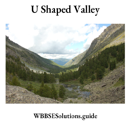
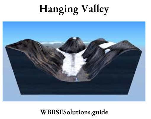
Question 1. Describe with sketches three landforms carved out by glacial erosion.
Answer:
The main landforms formed by erosion by glaciers are:
1. ‘U’ Shaped valley: The valley formed due to erosion on its bed and sides is called a ‘U’ shaped valley as it resembles the English alphabet ‘U’.
2. Corrie or Cirque: In the source region of the glacier, glacial erosion causes a’ depression in the rock bed, due to which the landform looks like an armchair. It is known as corrie or cirque. When it is filled with meltwater, it forms a cirque lake.

3. Hanging valley: Often the valley of a tributary glacier meets the valley of the main glacier. As the tributary glacier forms a smaller valley than the main glacier, it looks to hang above the main valley glacier. This valley of the tributary glacier is called Hanging Valley.
Question 2. Give an account of the atmospheric layers of the troposphere and stratosphere.
Answer:
Troposphere: This layer extends up to 16-18 km from the earth’s surface over the equator. It is the layer which is connected with the earth’s surface.
1. All the weather-making processes are confined to this layer.
2. Great contrasts in climate and weather are observed in different areas due to changes of temperature in this layer.
3. The presence of most of the water vapour in this layer is responsible for the condensation of clouds and precipitation.
4. Dust particles give rise to fog, clouds, smog, etc. in this layer.
5. Convectional currents are confined to this layer for the heating and cooling of the atmosphere.
Stratosphere: This layer is found up to a height of 50 km above the Troposphere. There is no formation of clouds in this layer and thus there is no weather. There does not exist any danger of the storm. That is why this layer is ideal for aircraft.
1. It is the second layer of the atmosphere above the earth.
2. Its height varies from 16 km at the equator and 72 km at the poles.
3. Temperature is very low and generally increases in the upper part of the layer.
4. It is the non-convective zone of the atmosphere.
5. Cloud, dust particles are practically absent in this layer.
Madhyamik Geography and Environment Important Questions 2023 Set 4 PDF
Question 3. Mention the location of Mediterranean climatic region and discuss its major climatic characteristics.
Answer:
Location of Mediterranean climatic region: The Mediterranean climate is the climate typical of the lands in the Mediterranean basin. The lands around the Mediterranean Sea form the largest area where this climate type is found, but it also is found in most of California, in parts of Western and South Australia, in southwestern South Africa, and in central Chile.
Characteristics:
1. The Mediterranean climate is characterised by dry summers and wet winters.
2. Due to the shifting of pressure belts, dry trade winds blow over the region during summer.
3. The westerlies bring rainfall in the region during winter.
4. During summer the climate is pleasant with an average temperature of 54°C.
5. Bright sunshine throughout the year is another feature of the climate.
Question 4. Discuss the influences of ocean currents on global climate.
Answer:
Influence of Ocean Currents: The various influences of ocean currents are as follows:
1. Difference in temperature: The regions where warm ocean currents pass, become comparatively warmer, while the regions where cold ocean currents pass become comparatively cooler.
2. Rainfall: Winds crossing warm ocean currents gather enough moisture and cause much rainfall. But winds causing cold currents do not gather much moisture, hence do not cause much rainfall.
3. Fog and Storms: Regions where warm and cold currents meet remain foggy almost throughout the year and often face storms.
4. Frost-free harbours: Warm currents help to keep the mouths of the harbours of higher latitudes frost-free even in winter.
5. Navigation: Ships can move faster and easily along ocean currents. The movement against the direction of currents is difficult, time-consuming and fuel-consuming.
6. Sandbars: When warm and cold currents meet, the icebergs carried by cold currents melt. The sand, pebbles, etc. being carried by the icebergs get deposited at the base, creating sandbars. These are economically useful as the low depth of the sea in this region attracts much fish which can be easily acquired.
7. Business and commerce: Sandbars are good for the growth of plankton, which is the favourite fish food. A huge number of fish are attracted to these regions. This leads to a huge catch of fish, naturally leading to good business and commerce.
Question 5. Explain the major factors controlling the climate of India.
Answer:
The controlling factors of Indian climate are:
1. Latitudinal location: Tropic of Cancer passes through the middle of the country. As a result, the southern half of the country falls in the Tropical zone while the northern half is in the warm temperate zone. But the country, on the whole, experiences a tropical temperate climate.
2. Monsoon winds: The word is derived from the Arabic word mausim, meaning season. Actually, monsoon winds are the enlarged form of land breezes and sea breezes. The land breeze and sea breeze blow for six months from sea and the other six months from land masses. In the summer season of the Northern hemisphere, low-pressure area is formed over the central hilly and mountainous region of Asia while a high-pressure area is formed in the southern hemisphere. The result is that winds blow from the South of the equator to the North and according to Ferrel’s law, they deflect towards the right. Thus the winds blow from a south-westerly direction. These are known as S.W. monsoon winds.
They divide into two branches: the Arabian Sea Branch and the Bay of Bengal Branch. They strike against the Western Ghat mountains giving
early and heavy rain to the coasts of Konkan and Malabar. The S.W. monsoon then loses its moisture and gives no rain or little rain to the Deccan trap (leeward side). Again, when it crosses the Bay of Bengal the winds become moisture-laden and join the Bay branch. It gives rain after striking the eastern Himalayas. Thus Andaman and Nicobar islands experience equatorial rainfall throughout the year and the western coast receives the first downpour of SW monsoon after striking the eastern Himalayas and giving rain to N.E. India and West Bengal. The monsoon currents move westward and give rainfall to the northern plain in the last week of June.
In winter the dry north-east monsoon brings rainfall to the eastern coast (the Tamil Nadu coast) after taking moisture from the Bay of Bengal. During winter the low pressure of the Bay helps in the formation of the cyclonic storm that strikes the coast of Orissa, Andhra Pradesh, and Tamil Nadu.
3. Inter Tropical Convergence: In the winter the Indian climate is influenced by the western disturbances originating from the Mediterranean sea and characterised by snowfall or rainfall (its influence is seen sometimes upto the plains of West Bengal also). Kashmir, Punjab, and Western U.P. receive snowfall or rain during this time.
4. Mountains: Mountains play a significant role in influencing the Indian climate. The Himalayas on one side obstruct the cold winter winds from coming over to India, otherwise, the country would have been a cold desert like Tibet, and on the other side, checks the moisture-laden SW monsoon winds resulting in rainfall throughout the country. Again, the Aravalli range is situated parallel to the direction of NE and SW monsoon
winds making the region rainless.
5. El-Nino and La-Nina: El-Nino is a warm surface ocean current that appears off the coast of Peru in South America. It is a temporary replacement of the cold Peruvian current flowing along that coast. It happens to increase the temperature of tropical Pacific waters by about 10°C causing flood and drought in the tropical regions of the world. India lying in the Tropical region also experiences such flood or drought situations due to its effect. La-Nina or anti-El-Nino is the cooling of surface ocean water along the tropical west coast of South America. It causes heavier summer monsoons in southeast Asia. This benefits the Indian economy, which depends on monsoons for agriculture and industry.
Question 6. Give an account of favourable physical conditions required for the cultivation of tea in India.
Answer:
Tea requires the following favourable geographical and economic conditions for growth:
Favourable Geographical Conditions:
1. Climate: Tea is a sub-tropical plant and needs a hot and wet climate.
Temperature: Tea requires temperatures between 10°C and 35°C. The growth is retarded if it falls below 18°C. The most suitable temperature for tea growth 25°C.
Rainfall: The tea plant needs rainfall varying between 150 cm and 200 cm. The rainfall should be well-distributed throughout the year. It cannot withstand long spells .of dry weather at any season of the year.
Humidity: High humidity, heavy dews and morning fog favour the rapid development of young leaves.
Winter frost: Widespread winter frost is harmful to the crop.
Shade: Tea is a shade-loving plant and develops more vigorously under light shade. Shade plants are generally grown in tea gardens to avoid direct sunshine on tea.
2. Relief: Almost all the commercially-managed tea plantations are located in highlands and on hill slopes where the natural. drainage is good. Tea cannot tolerate stagnant water and thus waterlogged lowland areas are least suited to tea cultivation.
3. Soils: Tea requires well-drained sandy loam with porous subsoil. The sandy loam is considered the best soil for tea cultivation. The soil must be deep and have a moderately open texture. Virgin forest soils, containing a good deal of iron and humus, are ideal for tea cultivation.
Favourable Economic Conditions:
1. Labour: Tea cultivation and processing are labour-intensive. The work of field preparation, weeding, manuring, pruning and picking goes on all year round on the tea estates. Tea plucking requires an abundant supply of cheap labour. Female labour is preferred for tea picking because it is a tedious job, requiring both skill and patience. Plucking demands a skilled manipulation of fingers, as with care, two leaves and bud are to be plucked out at a time.
2. Capital: Tea is very capital-intensive cultivation. Tea estate requires a heavy amount of capital.
3. Fertilizer: Tea is an exhausting crop, and as such, requires manuring of the soil.
Question 7. Explain why cotton textile industry is extensively developed in Western India.
Answer:
The favourable conditions for growing cotton are:
Geographical:
1. Temperature: 23° – 32°C with an average around 27°C.
2. Sunshine: Plenty of sunshine during the growing period and cooler conditions during harvest.
3. Rainfall: 50-80 cm of rainfall well-distributed during the growing period. But rainfall is injurious after the budding period.
4. Frost: At least 200 frost-free days are required.
5. Soil: Black cotton soil or regular soil is the best for cotton.
6. Land: Flat or undulating land with good drainage and no water logging is good for cotton.
Economic:
1. Labour: Much labour is required for planting, thinning of seedlings, hoeing, inspection of pests, picking of balls, etc.
2. Transport: Good transport system helps in carrying raw cotton to factories and finished products to markets.
3. Fertilisers and pesticides: Cotton is highly soil-exhaustive. Hence fertilisers are necessary to maintain soil fertility. Pesticides are used to control pest attacks.
4. HYV: High yielding variety of seeds like MCU-4, MCU-5, Hybrid-4, Sujata, Varalaxmi, etc. help to raise the yield of cotton per hectare.
Question 8. Discuss the major problems of Urbanization in India.
Answer:
The major problems faced due to urbanisation in India are:
1. Unplanned growth of urban areas: Rapid concentration of population in urban areas led to unplanned and unsystematic growth of towns and cities. Also, such unplanned growth of urban areas is engulfing much amount of the agricultural land in the outskirts.
2. Accommodation: The rapidly growing population is difficult to house in the already existing urban areas. Hence, the growth of slums and downtrodden areas is seen in the fringes of towns and cities.
Madhyamik Geography and Environment Question Paper 2023 Set 4 in Bengali
3. Availability of water: The amount of water available is not sufficient for the rapidly growing urban population. Hence, scarcity of water occurs.
4. Unemployment: A huge section of the population comes to urban areas in search of work. But all of them do not get employment. Hence, the total percentage of unemployed in the urban area increases.
5. Sewage and garbage disposal: The volume of disposable solid and liquid wastes is difficult to handle with the present sewage system of urban areas. Thus, water dumping and logging of drains occur in urban areas, especially in slum areas.
6. Insufficient transport, education, medical and other social facilities: The available transport, education, medical and other facilities are not enough for the rapidly growing urban population.
7. Pollution and environmental degradation: Over-population causes a high rate of pollution and misuse and over-use of resources cause environmental degradation.