
Chapter 10 Continent Of Africa
Introduction:
The continent of Africa is the second largest continent in the world (coming next to Asia). Africa is a huge continent of infinite variety. It is called an ideal continent.
Man is believed to have appeared first on the face of the earth in East Africa but till the end of the 19th century, Africa was known as the ‘Dark Continent’ as most of the continent was a mystery to the rest of the world.
The vast Sahara desert, dense unhealthy forests, and rugged topography prevented travelers from venturing into the continent.
Problems of accessibility, uncomfortably hot and humid climate, presence of beasts of prey, etc. the light of modern civilization could not reach this continent till recent times.
Read and Learn More WBBSE Notes for Class 7 Middle-Class Geography
So, this continent was commonly known as the ‘Dark Continent’. It is interesting that the ancient civilization of Egypt also took place in the northeastern part of the continent of Africa.
Location:
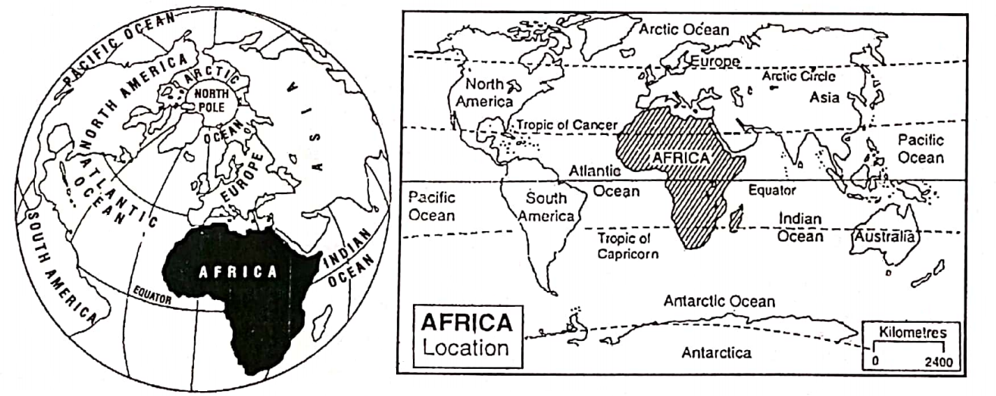
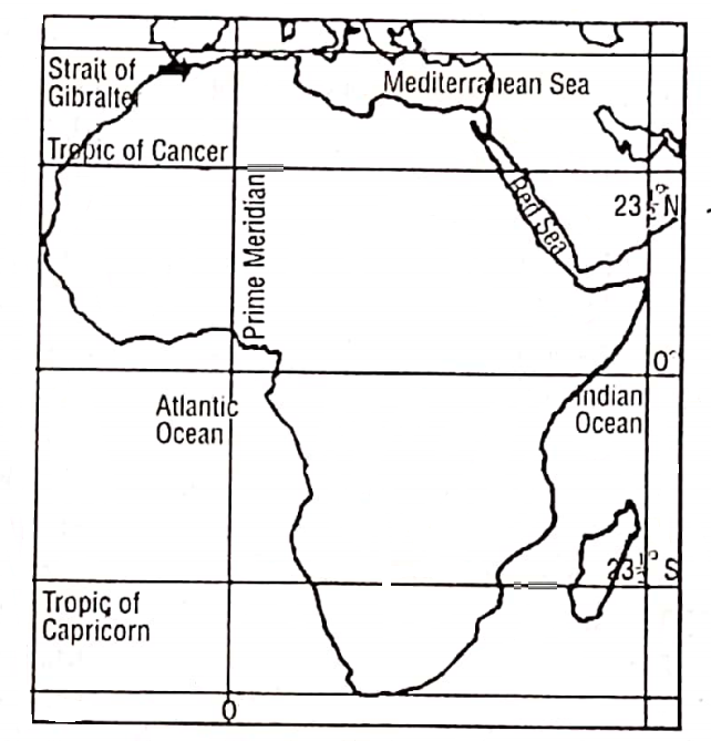
The continent of Africa is located to the south of Europe and to the southwest of Asia. From north to south Africa extends from 37° (37° 14′) north Parallel of latitudes to 35° (34° 50′) south parallel of latitudes.
Longitudinally Africa extends from 18° (17° 33′) west meridian in the west to 52° (51° 24′) east meridian in the east.
Therefore, three important parallels of latitudes, the Equator (0°), Tropic of Cancer (232°N), and Tropic of Capricorn (232°S) are extended through this continent.
The Equator, passing through the middle of Africa has divided the continent into the western part of North Africa. The Prime Meridian has divided the continent into two parts-eastern and western hemispheres.
“WBBSE class 7 geography chapter 10 notes”
Thus, Africa is the only continent that is crossed by the Equator, both the Tropics, as well as the Prime Meridian, and so, covers parts of each hemisphere-eastern, western, northern, and southern.
Boundary:
Africa is bounded on the north by the Mediterranean Sea and the Strait of Gibraltar, across which lies the continent of Europe. In the south are located parts of the Indian Ocean and the Atlantic Ocean.
The continent is bounded on the east by the Indian Ocean and on the northeast by the Gulf of Aden, the Red Sea, and the Suez Canal.
The Gulf of Guinea and the Atlantic Ocean are located on the western boundary of Africa. The narrow Red Sea separates Africa from Asia while the Isthmus of Suez used to join these two continents before the Suez Canal was dug across it in 1869.
In the northwest, the narrow strait’ of Gibraltar separates Africa from Europe. Africa may be called a ‘Continent of four seas’, because, the Mediterranean Sea, Red Sea, Indian Ocean, and Atlantic Ocean surround this continent.
Area:
The continent of Africa accounts for a fifth of the world’s land surface. It covers an area of 3,02,21532 sq. km which is nine times the -size of India. It is the second-largest continent in the world according to its size and population.
།
Extension:
Africa stretches for a distance of about 8000 km (5000 miles) from north to south and about 7400 km (4600 miles) from west to east. The northern part of the continent from east to west is wider and gradually tapers to a point in the South.
The tip of the continent is in the east of Africa is the Cape Guardafui, in the west is Cape Verde, in the north is the Cape Bon, and in the south is the Cape Agulhas. The famous ‘Cape of Good Hope lies in the south of Africa.
Population:
There are nearly 1-2 million people in Africa(2016).
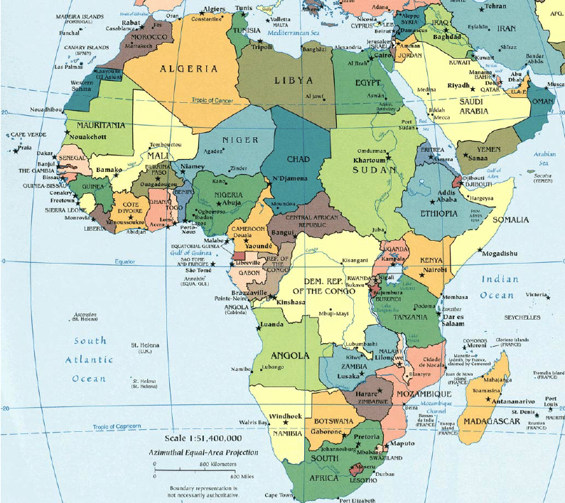
Chapter 10 Continent Of Africa Countries Of Africa
Chapter 10 Continent Of Africa Geographical Importance
- From a Geographical point of view, Africa is the second largest continent of the world, both in area and population. It is very much significant.
- This is the only continent through which the Equator, Tropic of Cancer, Tropic of Capricorn, and Prime Meridian are passing. So the continent covers each hemisphere of the world.
- It is a continent of massive mountains and peaks snow-capped all year round and much of the continent consists of a high plateau whose sides fall sharply to a narrow low coastal belt.
- The Sahara, the largest hot desert in the world is located in the northern part of Africa. Another hot desert, called ‘Kalahari’ lies in the southern part of the continent.
- In the eastern part of the continent, there is located the ‘Great African Rift Valley which is not only the longest but also the most important rift valley in the world. Depressions of this valley have turned into several lakes, such as Tanganyika Rudolf, Edward, etc.
- The longest river in the world, the Nile (6690 km) is flowing through this continent. The second largest river basin of the world, the Congo or Zaire river basin is also found in this continent.
- The continent of Africa has a great variety of its climate.
- Almost in the middle of this continent, there is an extensive tropical grassland called ‘Savanna’ and in the southern part of the continent, there is a temperate grassland called ‘Veld’. The dense forests and Savanna grasslands of Africa abound in wildlife attracting tourists from all over the world.
- In some places plantation crops like cocoa (Ghana and Nigeria) coffee (Ethiopia, Uganda, and Angola), and oil palm (Zaire) are grown. The Nile Basin is world famous for growing, very high-quality long-staple cotton (Egyptian cotton).
- The Cape Province in the Mediterranean climatic region of South Africa is famous for fruit farming.
- The African turbulent rivers are of great importance in generating hydroelectric power.
- Africa is very rich in minerals. About 95% of the world’s total diamonds and 50% of the world’s gold are mined in South Africa. The continent leads the world in the production of platinum and chromium. Other important minerals are copper (Zaire, Zambia, and Zimbabwe), uranium (South Africa and Zaire), Petroleum (Libya, Algeria, and Nigeria), bauxite, tin, etc.
- The historical importance of the continent is also very important, as the ancient civilization of Egypt took place in the northeastern part of the continent.
- Effective utilization of favorable physical environments, immense potentialities of raw materials, turbulent rivers for hydel power generation, forest resources, animal resources, and even human resources (huge population) may change this continent of Africa into the most developed and economically sound continent of the world.
Chapter 10 Continent Of Africa Physical Features Of Africa
Relief/ Physiography Of Africa :
Africa is a continent of plateaus. This vast plateau is called the ‘Continental Plateau’. The African plateau is very much diversified in its topography. The plateau varies in elevation between 305 m and 2440 m. But it is not generally mountains.
There are four physiographic divisions in Africa. These are as follows:
- Mountains in the North-West,
- Low plateaus of Central and North Africa,
- Highlands and Mountains of the East and South Africa and
- Coastal plains or Lowlands.
“continent of Africa WBBSE class 7 geography notes”
Mountains In The North-West
Atlas Mountain which stretches over 2250 km across North-west Africa in a series of ranges through Morocco, Algeria, and Tunisia, belongs to the fold mountain system.
The ranges are a continuation of the Alps of Europe and were formed when the Himalayas originated.
It is named after Atlas, the ancient Roman God of this region by the Greek people who live on the other side of the Mediterranean Sea. From north to south, the ranges are-
- Rift Atlas in the north,
- Middle Atlas to the south-west of it and
- Tell Atlas to the east of it (Tell means ‘terrace’). The ranges slope down to the Mediterranean coast is called the Tell Atlas or the Mediterranean Attas, A fertile land known as ‘Tell’ lies on the north of the Mediterranean or Tell Atlas. The main range of the Atlas is called the Great Atlas.
- Great Atlas is located to the south of the Middle Atlas. It has a few peaks of considerable height. The highest mountain peak in the entire region is Jebel Toubkal (4167m). It is on the Great Atlas.
- SaharanAtlas is located to the south of the Tell Atlas.
- The Anti-Atlas is located to the south of the Great Atlas. The highest peak of the Saharan Atlas is Chelia (2328 m). In between the Tell Atlas and the Saharan Atlas, there are many salt lakes, called ‘Shotts’.
Low Plateau Of The Central And North Africa
This is an extensive plateau that extends from the Atlantic coast in the west to the Nile river in the east. It is not so high. Average height ranges between 300 m and 600 m. It slopes towards the north and west.
The plateau is relatively higher in its central part, called the Tibesti, wherein lie many peaks, such as Emi Koussi (3415 m). The most significant part of this plateau is ‘The Sahara’, the largest hot desert in the world.
“exercise 10 solved questions on continent of Africa class 7”
Other important deserts are the Libyan and Nubian deserts. The plateau of Ahaggar lies in the middle of the Sahara. Ahaggar or Hoggar (2918 m) is the highest point of the residual uplands of Ahaggar.
Lake Chad lies in the south of the Sahara Desert. There are hundreds of oases scattered throughout the Sahara. Fouta Djallon, Kong, and Cameroun Mountains are situated to the north of the Guinea coast.
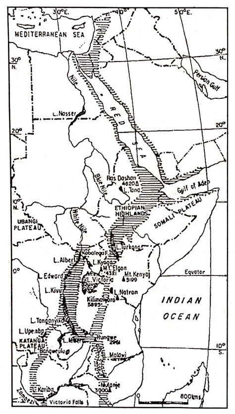
Highlands And Mountains Of The East And South Africa
This is the highest part of Africa. Highlands stand in the eastern and southern parts of Africa. The low plateaus of Central Africa have gradually increased in height and have merged into the highlands of Abyssinia or Ethiopia. The average height is about 2000 meters.
The Eastern Highland is characterized by its spectacular feature, the ‘Great Rift Valley which is the longest, about 6400 km. of the world. The largest rift valley extends from the Red Sea coast in the north up to Mozambique in the south.
The ‘Great Rift Valley’ has two arms- western and eastern-joined together. The western arm extends to the north from lake Malawi through lake Tanganyika-one of the world’s deepest lakes, lake Kivu, Edward, and finally up to lake Albert.
The eastern arm extends from Malawi through lake Turkana (Rudolf) to the Red Sea and then through the Gulf of Aqaba to the Dead Sea in Jordon. Lake Victoria, Africa’s largest and the world’s third-largest lake, lies between the two arms of the rift valley on the surface of a plateau.
Several mountain chains radiate from the Ethiopia mountains in the north-south direction. The northern range stretches northward along the Red Sea coast. The southern range runs parallel to the east coast.
The southern range has formed a few peaks of considerable altitude. Mount Kilimanjaro (5895 m) Africa’s highest mountain peak lies here. Mt. Kenya (5194 m), Mt. Kilimanjaro, and Mt. Kenya are of the Block mountain group. Mt. Ruwenjori, Mt. Elgon, etc. are also important. These are extinct volcanoes.
“WBBSE class 7 geography chapter 10 important questions”
Southern Highland is very high and has formed a great mountain wall by the Drakensberg or “Dragon’s mountain”. New Veld mountains are situated at the southern edge of the south African plateau.
They are the old fold mountains. The southern mountain plateau descends the sea by a series of steps of considerable width. These steps are called Karoos. They are noted as ‘Great Karoo’ and ‘Little Karoo’.
Bigger steps are called ‘Great Karoos’ while the smaller ones as ‘Little Karoos’ in the Cape Province of South Africa. To the west of this plateau, there are two hot deserts-the Kalahari and the Namib.
The Coastal Plains Or Lowlands
All around the continent, the narrow coastal plains form the major lowlands of Africa. The coastal lands of Africa are low. They are below 200 meters in height. The Coastal plains of the Mediterranean Sea in the north and the Atlantic Ocean in the west are a little wider.
Africa lacks low plain lands except for narrow basins of the Zaire river, the Zambezi river, the Orange river, the Niger river, the Nile river, etc. The Volta river basin and the riverine e plain of Gambia are also important. The coastline of Africa is not broken but is very long.
“physical features of Africa class 7 geography”
In Africa, there are a few islands, such as Madagascar (the largest island of Africa) and Zanzibar in the east, Canary and Madeira in the northwest, and St. Helena in the west.
Chapter 10 Continent Of Africa Rivers Or Drainage System Of Africa
Many rivers are found in the continent of Africa. The characteristic features of the rivers or drainage system of Africa are as follows:
- Africa has many great rivers. The Nile is the longest river in the world and the Congo or Zaire river has the second-largest river basin in the world.
- Compared to the vast size of the continent, rivers are fewer in number because of their climate which is mostly hot and dry.
- Most of the rivers of Africa rise in the plateaus and have long navigable courses over the plateaus until they reach the edge.
- Near the coast where the plateaus and the rivers drop down as waterfalls or rapids.
- Big waterfalls and many rapids prevent continuous river transport. It is very difficult and nearly impossible for boats or steamers to move inland from the sea.
- The African rivers are of great importance in generating hydroelectric power.
- There are some inland rivers in Africa.
- Many important lakes of different types are also found in Africa.
According to their direction of flow rivers of Africa may be grouped into the following categories:
- North-flowing rivers;
- West-flowing rivers,
- East-flowing rivers, and
- Inland rivers.
Important Rivers Of Africa
| Types of Rivers | Name of the Rivers |
| 1. North-flowing Rivers | The Nile |
| 2. West-flowing Rivers | 1. Congo or Zaire, 2. Niger, 3. Senegal, 4. Gambia, 5.Orange etc. |
| 3. East-flowing Rivers | 1. Zambezi, 2. Limpopo. |
| 4. Inland Rivers | 1. The Chari, 2.Lo, etc. |
North Flowing Rivers (Mediterranean Drainage System)
The Nile (6690 km):
This is the longest river in Africa as well as in the whole world. ‘Nile’ is a word derived from the Latin word ‘Nilus’ means ‘which source is unknown’.
The The’Kagera’ river originating in the highlands of Rwanda-Burundi and falling into Lake Victoria is believed to be the source of the Nile river.
The river flows Straight to the north up to the tenth parallel in Sudan. Here the river is known as the Bahr-El-Jebel. From the west comes the river Bahr-El-Ghazal and the Sobat from the east.
The combined course of these rivers flows by the name White Nile which is the main stream of the Nile. The longest tributary of the Nile, the Blue Nile joins the White Nile to form the Nile at Omdurman and Khartoum on the left and right banks respectively.
Between Khartoum and Aswan the Nile passes through six cataracts and receives another tributary, the Atbara coming from the north of the Ethiopian Highlands.
From Aswan to Cairo is the lower course of the Nile and the delta course from Cairo to its mouth. The river Nile formed a large delta as it meets the Mediterranean Sea.
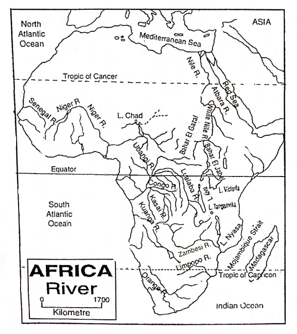
West Flowing Rivers (Atlantic Drainage System)
The Congo or Zaire (4700 km):
The Congo renamed Zaire (from ‘Zari’ means ‘huge mass of water’ is the second largest river in Africa and has the world’s second-largest river basin after that of the Amazon. The river originated in the plateau of Katanga, southwest of lake Tanganyika along the Zambia-Zaire border.
In the source region, the river is known as Lualaba. The river flows as Zaire after crossing the Equator. This river has crossed the Equator twice, and therefore, receives much volume of water through its different tributaries.
The mighty river cuts through the heart of the dense equatorial forest of Africa in a long twisting course until it reaches the waters of the Atlantic.
“major mountain ranges and rivers in Africa WBBSE”
The Ubangi (1400 km) and Kasai (2153 km) are important tributaries, and along with the main river, serve as important waterways. The river has formed two well-known waterfalls, such as Stanley and Livingstone.
The Niger (4180 Km):
This is the third longest river in Africa and the principal river of west Africa. It rises as the ‘Tembi’ in the highland of Fouta Djallon along the Guinea Sierra-Leone border.
Then it flows northward and finally turns southward to drain into the Gulf of Guinea in the Atlantic Ocean. The river drains of an area of 1.5 million sq. km affect the lives of millions and are rightly called the ‘life giver of Mali and Niger’.
In the lower reaches, the river is joined by its most important tributaries the Benue – the largest tributary and the Kaduna. Below the confluence of the Benue the river delta begins.
Senegal (1641 Km):
Senegal is an important river in west Africa. It rises in the Fouta-Djallon highlands and meets the Atlantic Ocean. Senegal is a navigable river that flows along the northern border of the ‘Republic of Senegal’. The Senegal river is the longest river in the Republic of Senegal.
The Gambia (1120 Km):
The Gambia is also an important river in West Africa. It rises in the Fouta-Djallon highlands flows through the heart of the Republic of Gambia and meets the Atlantic Ocean.
The Volta (1600 Km):
The Volta is the most important river of Ghana, which has two main branches-the White Volta and the Black Volta. Rising in the Guinea highlands, the river empties into the Atlantic Ocean.
The Orange (2140 Km):
The Orange is the longest river in the Republic of South Africa as well as the fifth longest river in Africa. It originates in the Drakensberg Mountains of South West Africa and flows westward through semi-desert and desert areas.
Then it flows through the grassland of Veld towards the west to drain into the Atlantic Ocean. The river Vaal is an important tributary of the Orange River.
Twenty-nine reservoirs have been constructed on this river for irrigation and a number of hydel power stations are developed on this river.
East Flowing Rivers (Drainage System Of Indian Ocean)
The Zambezi (3540 Km):
This is an important river in South Africa and it is the fourth largest river in Africa. The river originating in the western part of the southern highland flows southward and then curves eastward to meet the Indian Ocean (Mozambique Strait).
The magnificent and world-famous Victoria Falls lies on this river. With a height of 108 meters (more than twice as high as the Niagara Falls of North America), the falls stretch for more than 16 km across Zambia from Zimbabwe.
The Kariba dam on the Zambezi in Zambia is 128 meters high and its reservoir is among the largest (5180 sq. km) of all man-made lakes. The Cubango is an important tributary of the Zambezi.
The Limpopo (1900 Km):
This is another important river in South Africa. It originated in the western part of Transvaal and flows eastward to drain into the Indian Ocean through Mozambique. The river is infested with crocodiles. Hence the Limpopo river is also known as ‘The Crocodile river’.
Chapter 10 Continent Of Africa The Inland Drainage System
There are some inland rivers in Africa. An inland river does not have any outlet to the sea. So an area of inland drainage is an area where all the rivers drain into an inland lake.
An important area of inland drainage in Africa is the Chad Basin that lies to the south-east of the Sahara. The Chari, an intermittent river and ‘Lo’; one flows into Lake Chad that occupies the central part of this basin.
Another area of inland drainage is the ‘Okavango (Cubango) basin of Botswana in southwest Africa.
Lakes Of Africa
There are a few big lakes in Africa. These lakes are of two types, i.e.
- Fresh water lake and
- Saline water lake.
1. Freshwater Lake:
‘The great Rifl valley’ in East Africa consists of a number of lakes, such as Tanganyika, Rudolf, Malawi, Albert, Edward, etc. Tanganyika (672 km) is the longest as well as the second deepest (1436 m) freshwater lake in the world.
Near the Equator, there is lake Victoria which is the largest lake in Africa and the second-largest freshwater lake in the world. Other important freshwater lakes are Tana and Abaya located in the Ethiopian highland and Benguela lake located in the mountains region of Zambezi.
2. Saline water Lake:
In the southern part of the Sahara desert lies Lake Chad, which is a saline water lake. In northwest Africa, there are a few small saline water lakes in between the Atlas mountain and the Sahara desert.
These small saline water lakes are known as ‘Shotts’. (Arabic word ‘Shott’ means ‘Saline water’).
Chapter 10 Continent Of Africa Climate Of Africa
There is a great variation in the climate of Africa. The general characteristic features of the climate of Africa are as follows:
- The climate of Africa is very much diversified, such as a hot humid equatorial climate as well as a hot desert climate and even a Mediterranean climate prevails here.
- The climatic features of the places near the seas or oceans are different from the places far from them.
- The climate also differs from the plains to the mountain regions.
- Some areas of Africa get heavy rainfall (200 cm) throughout the year, while some other areas get less than 25 cm in a year.
- Some areas record the world’s highest temperature while a few places on the Equator remain snow-capped even in summer.
- The continent is located on both sides of the Equator. The upper part of this continent is located in the northern hemisphere and the lower part is in the southern hemisphere. Hence, exactly opposite seasonal changes are found in the northern and southern hemisphere, i.e. when summer exists in the north, winter prevails in the south.
Chapter 10 Continent Of Africa Factors Affecting The Climate Of Africa
There are great contrasts in the climate of Africa and these are controlled by the following factors:
Latitudinal Extent
Africa extends from 37′ 14′ north to 34° 50′ south latitude. So Africa is the only continent in the world that extends equally into the northern and southern hemispheres.
The Equator (0°) the tropic of Cancer (23%1⁄2°N) and the Tropic of Capricorn passes through this continent. So, it is mostly located in the Tropical, sub-tropical, and Equatorial climatic regions.
About 75% of Africa lies within the Tropical zone. So, most of the continent is hot throughout the year.
Altitudinal Factor
Temperature decreases at the rate of 6.4°C for 1000 meter (1 km) increase in altitude. Eastern Highland of Africa, though located in the torrid zone, enjoys a cool climate because of its high altitude.
Mount Kilimanjaro, though located in the Equatorial region remains snow-capped throughout the year. For the same reason, the higher southern Plateau also remains cool.
Distance From The Sea
Extremities of temperature increase with the distance from the sea/ocean. Because of its shape, the northern part of Africa has extremes of temperature. Places in the heart of north Africa are far away from the moderating influence of the oceans.
So, they are very hot in summer and very cold in winter. On the other hand, temperatures in the narrower southern part of Africa are more uniform.
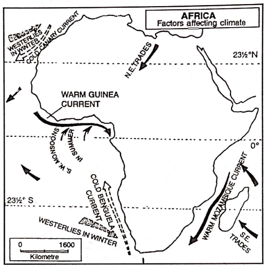
Ocean Currents
Warm and cold ocean currents move along different parts of the African coast. The cold scenery and Benguela currents keep temperatures down in the northwestern and extreme southwestern coasts, respectively. On the other hand, the warm Mozambique and Guinea currents have a warming influence on the south-eastern and western coasts respectively.
Planetary Winds
Trade winds blow from the sub-tropical high-pressure belt to the Equatorial low-Pressure Belt. They do not give any rain to the western part of the continent and are also responsible for the formation of the Kalahari and the Namib desert.
Chapter 10 Continent Of Africa Seasonal Conditions Of The Important Elements Of Climate In Different Parts Of Africa
Temperature:
Summer occurs in North Africa in the month of June-July and the highest temperature of 52°C prevails over the Sahara Desert. In South Africa where it is winter, the temperature of the Drakensberg mountain in south-east Africa is only 4°C.
From December-January it is winter in North Africa and summer in South Africa. So the temperature of the Sahara Desert drops to 4°C, while it remains high at 21°C in the southern parts of Africa.
In the equatorial region, however, the average temperature throughout the year remains around 27°C, it has year-round summer.
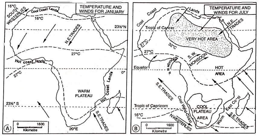
Air Pressure And Winds
As the Equator, passes through the middle of Africa, Central Africa is under the Low-Pressure Belt and the northern and Southern parts of Africa are under the sub-Tropical High-Pressure Belts.
“climate and vegetation of Africa class 7 notes”
So, the North-East Trade wind blows over North America. But with the movement of the sub-solar point, Pressure, and Wind Belts also shift. So, in Winter, ‘Westerlies blow over the extreme southern and northern parts of Africa.
Rainfall
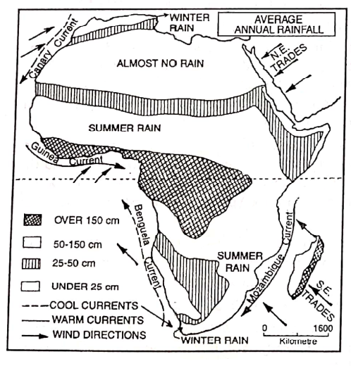
In general, rainfall decreases as one goes north or south of the equatorial region, and most of Africa has less than 50 cm of rainfall. Central 1600 Africa as located in the equatorial region receives heavy convectional rainfall throughout the year with an annual average of 150 cm.
Rainfall is less than 15 cm annually in the Sahara Desert. Monsoon wind coming from the Indian Ocean gives rain to the east coast of Africa.
The Sahara, Namib, and the western margins of the Kalahari desert have less than 25 cm of rainfall annually and are truly arid in character.
Chapter 10 Continent Of Africa Climatic Region Of Africa
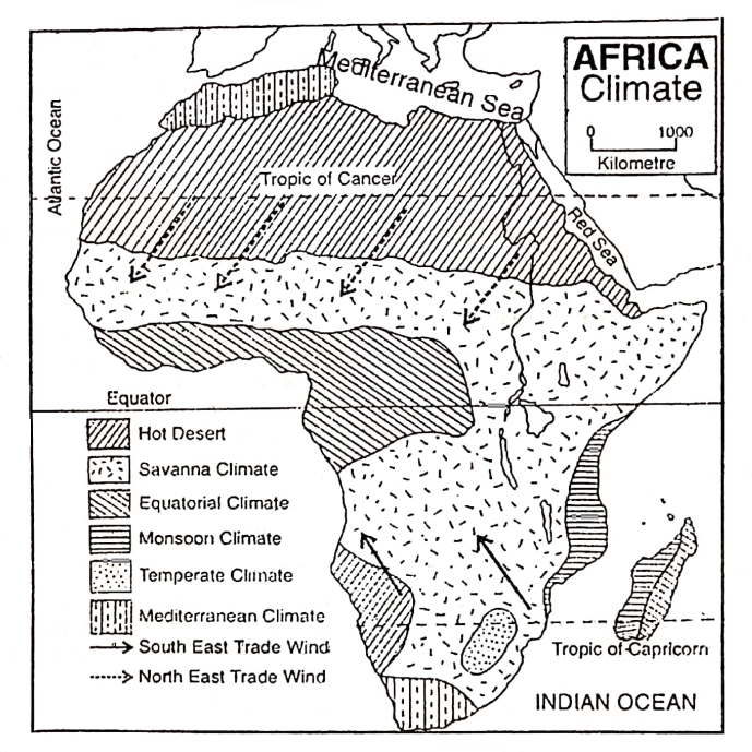
Based on variations in temperature, air pressure wind, and rainfall, the continent of Africa may be divided into the following seven climatic regions.
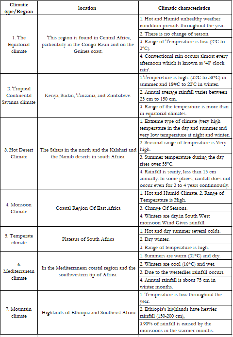
Chapter 10 Continent Of Africa Natural Vegetation Of Africa
As in other parts of the world, climate especially rainfall influences the natural vegetation of Africa to a great extent. According to the variation in climate (mainly temperature and rainfall), altitude, soil, and geographical location, the natural vegetation of Africa may be broadly divided into Seven Natural Vegetation Belts.
Let us now discuss the different types of natural vegetation growing in different regions of Africa.
Equatorial Evergreen Forests
These forests are found mainly in the Congo or Zaire Basin and the Guinea coast of Africa. These forests are also known as equatorial rainforests. The hot and humid climate favors the growth of dense forests. So, the trees are very huge and tall.
As there is heavy rainfall throughout the year, the trees are evergreen and have broad leaves. Entering or traveling through these forests is virtually impossible because of the dense undergrowth of shrubs and creepers.
Numerous tall hardwood trees like ebony, mahogany, rosewood, and ironwood and giant woody creepers called lianas grow here profusely and form a thick canopy through which no light can penetrate. So, this forest is called the ‘land of eternal twilight’.
The equatorial forests of the Zaire basin are the second largest area of rainforests in the world. These forests are quiet. inaccessible, and serve as a natural wildlife reserve. It is only here in the world that gorillas are found.
“population and cultural diversity in Africa WBBSE”
Other important animals are the elephant, hippopotamus, baboon, chimpanzee, okapi, wild buffalo, monkey, harmful tse- tse flies, poisonous ants, reptiles, crocodiles and the mamba-a dreaded poisonous snake.
Thousands of species of trees are scattered all over the forest. As a result, it is difficult to obtain timber or forest products from these forests.
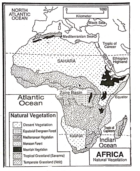
Tropical Or Savanna Grass Land
Extensive tropical grasslands, known as ‘Savannas’ are found to the north, south, and east of the equatorial evergreen forests. As rainfall decreases, the dense rainforests gradually thin out and are finally replaced by tropical grasslands called ‘Savanna’ (From Spanish ‘Zavana’ meaning ‘a treeless plain’).
During the wet summer, the tall coarse grass of the Savanna is lush green but during the dry winter, they dry up and turn brown. This grassland, in some places, is dominated by very tall (3 to 5 m) ‘Elephant Grass’.
In general, the grassland is dotted with dwarf trees like the baobab, tamarind, and many species of acacia including the gum arabic of Sudan. For this park-like appearance, this type of vegetation is called ‘Park land’.
The Savanna is the home of Herbivorous animals, like deer, zebra, elephant, double-horned rhinoceros, and giraffes. Carnivorous animals, such as lions, leopards, and hyenas are common here. So Savana grassland is also known as the ‘Paradise of hunters’. Hippopotamus and crocodiles are found in the rivers.
Temperate Grasslands (Veld)
This type of grassland is founds in the Southern parts of the African plateau. The grasses are softer, juicier, and shorter than that of Savanna. The grassland is known as ‘Veld’. ‘Veld’ comes from the African word ‘Veldt’ meaning ‘field’. The veld is used as an ideal grazing ground for cattle and sheep.
Humid Sub-Tropical Vegetation Of Monsoon Forests
This type of vegetation is found on the eastern slopes of Drakensberg mountain along the eastern coasts of Mozambique, Tanzania, Kenya, Somalia of East Africa, and in Madagascar Island.
Owing to high temperatures and heavy rain (above 100 cm) that occur mainly in summer these areas have dense forests of tropical hardwood deciduous trees. Here, forests of sal and bamboo trees are found. The trees shed their leaves in the dry winter season due to a lack of moisture.
Mediterranean Vegetation
This type of vegetation is found in the Tell Atlas region along the coasts of the Mediterranean Sea in north Africa and the Cape Province on the southern coasts of South Africa. These places have long, hot, and dry summers and wet but short, cool winters.
So the warm temperate evergreen trees which grow here, have long roots to reach deep down into the soil. Their banks are thick and leaves are waxy or oily to prevent loss of moisture during the long dry summer. Cork oak, birch, mulberry, olive, fig, and citrus trees like orange and lemon are the important trees of this region and the vine is the main creeper.
Olives, lemons, and grapes are produced so much that the region is called the ‘Orchard of the World’. Cedar and cypress trees are found in higher altitudes.
Hot Desert Vegetation
There is very little plant growth in the hot and extremely dry desert regions of the Sahara in north Africa and the Namib and Kalahari in South Africa. In these regions, vegetation is very much scanty and comprises thorny scrubs.
Only drought-resistant plants like cacti, date palms, thorny bushes, and grasses grow here.
Grasslands are used as pastures where camel, sheep, and goats are reared. Camels are often referred to as the ‘Ship of the Desert’ because they are used as a carrier of people and goods.
Mountain Vegetation
In the highlands vegetation changes with an increase in altitude. Thus the major part of the mountainous region of East Africa has a cool temperate forest with upland pastures.
Ethiopian Highland and Mountain regions of southern parts of Africa are covered by coniferous trees and also broad-leaved forests. Giant trees like camphor, cedar, yellow wood, and also bamboos grow in East African highlands.
Chapter 10 Continent Of Africa The Nile Basin
Introduction:
The Nile Basin is an important region of Africa. It is a fertile and green tract and has fostered one of the earliest civilization-the Egyptian civilization thrived in the Nile Basin. The Nile gives immense benefits to the countries through which it flows.
This is particularly true for Egypt and Sudan whose economy is greatly indebted to the Nile, without which rainless Egypt would have become a desert part of the vast Sahara.
Centuries ago the famous Greek historian Herodotus described Egypt as the ‘Gift of the Nile’. He was referring of course to the life-giving water and the rich silt that the Nile carries from equatorial Africa to the hot desert of Egypt.
Even today the river is the lifeblood of Egypt and the Nile Valley-largest oasis of the world in the heart of the Sahara.
Location:
The Nile, 6690 km long, is the longest river in the world and flows in Africa from south to north through the countries of Burundi, Rwanda, Tanzania, Zaire, Kenya, Uganda, Ethiopia, Sudan, and Egypt. But 75% of the Nile Basin lies in Egypt and Sudan.
The Area Of The Nile Basin :
The Nile Basin covers an area of 3.35 million sq. km ( a tenth of Africa)
The Course Of The Nile River:
The name ‘Nile’ is derived from the word ‘Nilus’ meaning ‘which source is unknown’. It is usually considered that the river ‘Kagera’ forms the headstream of the Nile. It rises near the northern tip of lake Tanganyika and flows west to meet lake Victoria, the largest lake in Africa.
The course of the river between lake Victoria and lake Albert is known as ‘Victoria Nile’ or the ‘Albert Nile’, and then as Bahr el-Jebel (the river of the mountain). Two tributaries of the river, the Bahr- el-Ghazal and the Sobat meet the Bahr-el-Jebel in the Sudd region at a latitude of about 10°N.
The former comes from the west and later from the east at Malakal and flows as the White Nile. The main tributary or another part of the Nile-the Blue Nile that supplies 70% of Niles’s flood water flows down from the south of lake Tana in the Ethiopian highlands.
The two rivers (The White Nile and the Blue Nile) meet at Khartoum (the capital of Sudan) and flow as the Nile. Between two rivers lies a vast flood plain called the ‘Gezira plain’.
“natural resources and industries in Africa class 7”
Then the Nile flows northward through the desert belt of Sudan and Egypt, it receives its last tributary the Atbara. In this desert belt, the Nile flows through a narrow valley and over a series of six rapids, known as ‘Cataracts’ which make this section unfit for navigation.
The course of the Nile between Aswan and Cairo is actually, extended through the Egyptian Desert, the Delta course of the river the Nile starts from Cairo the Nile has divided into seven distributaries forming a large delta (the famous Nile delta) and finally discharges, its waters to the Mediterranean Sea.
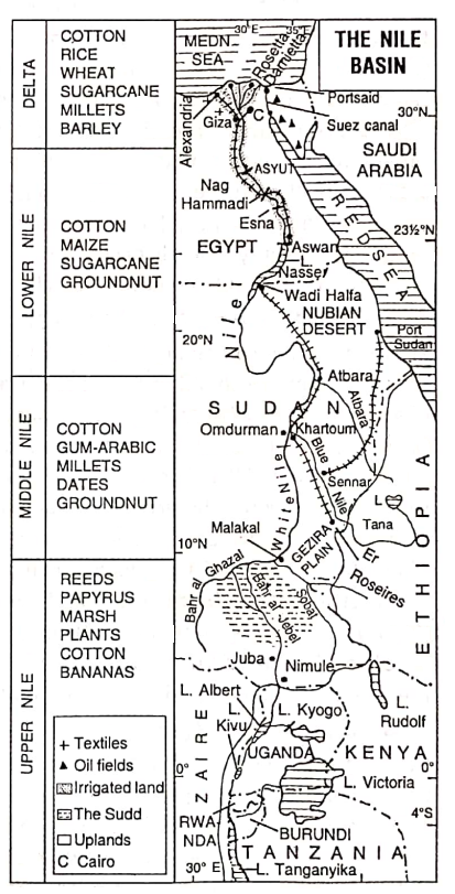
Different Parts Of The Nile Basin
According to the characteristics of the river course from the source to mouth, the Nile Basin can be sub-divided into the following parts:
- Source Of The Nile: Burundi Highlands.
- Upper Course Of The Nile: Lake Victoria to Malakal of Sudan.
- Middle Course Of The Nile: Malakal to Khartoum.
- Lower Course Of The Nile: Aswan to Cairo.
- Delta Region Of The Nile: Cairo to the Mediterranean Sea.
Tributaries Of The Nile
- Bahr-el-Ghazal (the deer river) is the only left-bank tributary of the Nile.
- Sobat,
- Blue Nile (the largest tributary of the Nile),
- Atbara is the right bank tributaries of the Nile.
Climate Of The Nile Basin
The Nile Basin extends from 4° south to 32° North latitude thus covering a vast latitudinal extent of 36°. Hence the Nile Basin enjoys different types of climates:
- The upper basin (in the source region) shows an equatorial type of climate. Here the temperature is high throughout the year and rainfall is of convectional nature and is heavy too.
- Monsoon climate prevails over the Ethiopian Highland near the source of the Blue Nile and Atbara rivers.
- A hot and dry Savanna type of climate is found in Sudan. High temperatures and scanty rainfall occur here in summer.
- An extreme type of Hot Desert climate is found along the Nile Basin in Egypt.
- The delta region is under the influence of the Mediterranean type of climate. Scanty rainfall occurs in winter and both the summer and winter have mild temperatures. It should be noted that the climate in the major part of the Nile Basin is desert-type.
Natural Vegetation
- Dense Evergreen Equatorial Rain forests as well as mixed forests are found in the source area.
- Extensive grassland or Savannas, scrub, and acacias including thorny bushes are found in Sudan because of scanty rainfall. The Gum Arabic tree, a species of acacia from which gum is made, is found in this region. Sudan is the world’s largest producer of gum.
- Cactus, Acacia, and thorny bushes are also grown along the Nile Basin in the Egyptian Desert.
- The flat clayey plain of Sudan remains waterlogged during the rainy season. This favors the growth of aquatic plants including tall grasses sedges, reeds, papyrus (from which the ancient Egyptians made paper), and water hyacinth. Frequently these masses of vegetation break off, float downstream, and choke the mainstream that is why the vegetation is collectively called ‘Sudd’ meaning ‘barrier’, and the region is known as ‘Sudd’ region.
- In the desert region, there is little or no vegetation, and date palms are found near the oases.
- Olives, figs, and citrus fruits grow in the Mediterranean region.
- Densely settled areas of the Nile Delta are almost devoid of vegetation.
Irrigation And Agriculture
Agriculture of the Nile Basin depends on irrigation water from the Nile. Basin irrigation has been in practice in the Nile Valley for the last 5000 years.
Other than this the Egyptian fellahin (Peasants) use water pumps and other methods such as Archimedean Screw, Shaduf (donga), and Saquia (Water wheels) to draw water from the canals and the river.
Sometimes irrigation is practiced through Persion wheels by lifting water collected in the depressions. The most modern method of irrigation is practiced by constructing dams across the Nile. Thus agricultural fields are irrigated throughout the year.
Dams and barrages constructed over the river Nile are-
- Aswan Dam on the Nile in Egypt, Aswan High Dam, about 6 km south of Aswan Dam and
- Sennar Dam on the Blue Nile
- Asyut Barrage,
- Nag Hamdi, Esna Barrage,
- Delta Barrage etc.-Aswan dam has been constructed on the river Nile mainly to control floods and supply water for irrigation in the agricultural lands. But there are other objectives for the construction of dams. When dams are constructed on a river with a view to fulfill many objectives the project is called a ‘multipurpose river valley project’.A number of multipurpose projects have been on the river Nile.
Agriculture
75% of the Nile Basin lies in Sudan and Egypt. In Sudan, the world’s finest long-staple cotton is grown in the Gezira plain. Other crops grown here are dates, groundnuts, and millets.
The chief agricultural crop in the Egyptian part of the Nile Basin is long, silky cotton. ‘Egyptian cotton’ is famous for its high quality.
Egypt is the world’s major producer of long-staple cotton. Other crops are rice, wheat, sugar cane, corn, barley, sweet potatoes, millets, oat, ground nut, dates, tobacco, etc. Vineyards are common on the cooler Mediterranean coast to Alexandria.
Animal Husbandry
The availability of fodders like berseem (Egyptian clover), alfalfa, etc., and the prevalence of fallow lands and the arid lands on the edge of the desert have made stock rearing an important occupation of the Egyptians. Sheep, water buffaloes, goats, donkeys, and camels are reared.
Minerals
The Nile Basin is not so rich in mineral resources. But some minerals, such as Limestone, Manganese, Phosphates, Talc, Asbestos, Common salt, Mineral oil, Lead, etc. are found in Egypt and Sudan. Some minor deposits of gold, iron ore, and copper are found in the middle Nile valley i.e. in Sudan.
Industries
A number of industries have developed in Egypt and Sudan due to the availability of raw materials, sufficient supply of water, abundant labor, supply of hydroelectric power, etc. in the Nile Basin. Agro-based industries are well-developed.
Among the growing industries cotton textiles, sugar milling, wine and alcohol, and vegetable oil processing are important cotton textile is the principal industry of Egypt. The principal cotton textile center in Alexandria.
“major countries and capitals of Africa WBBSE geography”
Other industries are woolen textile, leather, cement, fertilizer, oil refining, silk, rayon, and linen. Metallic industries have not developed here due to a lack of minerals. As the industries are fed by imported coal the concentration of modern industries is found in the cities, of Cairo and Alexandria.
Transport System
The Nile is still the main highway of communication. The lower Nile below the first cataract at Aswan is fully navigable. Motor transport is also well-developed in the lower valley.
The Blue Nile and the White Nile river provide most of the transportation between the middle and southern areas of Sudan owing to the existence of five cataracts between Wadi Halfa in the Horth and Khartoum in the south a railway line has been constructed to establish links with Egypt.
In other parts of the Nile Basin also, roads and railways are spreading their network and gaining importance rapidly. Khartoum, Cairo and Alexandria have international airports.
Population
The maximum population is found in the delta region of the Nile Basin. Due to developed agriculture, industry, and communication system benefits dense population occurs over the region where the density is around 1750 persons per sq. km.
Most of the Egyptians (80%) live here. The rest of the people live around the Oases. Recently a number of desert cities are being developed to attract people away from the overcrowded Nile valley.
Chapter 10 Continent Of Africa Important Cities And Ports
Important cities and ports in the Nile Basin are Cairo, Alexandria, Giza, Port Said, and Port Suez of Egypt, and Khartoum and Omdurman of Sudan are worth mentioning.
Cairo:
The main city in the Nile Basin is Cairo (At Qahirah), the capital of Egypt, which lies where the Nile begins to spread out into a delta before entering the Mediterranean Sea. It is the most important city, a famous industrial and trade center.
It is the largest city in Egypt as well as the largest city in Africa. It is also the largest city of the great Sahara and the largest desert city in the world.
Alexandria :
Historically famous city Alexandria (Al-Iskandariya), is located at the extreme northwest of the Nile. Delta is the chief and the second largest city in Egypt as well as Africa. It was founded by Alexander the Great in 332 B.C./331 B.C. It is the most important industrial center of Egypt.
Giza:
The third largest city in the Nile Basin of Egypt is Giza. It is situated near Cario and is famous for the Pyramid and Sphinsk of Africa.
“chapter 10 continent of Africa long and short questions”
Port Said:
Port Said is a small but important port on the Mediterranean coast. This port of call for passenger steamers lies on the western part of the delta region of the lower Nile Basin.
Khartoum:
Khartoum (Al-Khurtum) is the capital and chief industrial town of Sudan. It is situated on the edge of the desert at the junction of the Blue Nile and the White Nile. It is also the major market center of Sudan.
Omdurman :
It is the sister city of Khartoum. It is also situated on the edge of the desert at the junction of the Blue Nile and White Nile.
Egypt Is The Gift Of The Nile
Actually, Egypt is a rainless sandy desertic country occupying the eastern part of the Sahara desert. Annual rainfall is less than 25 cm. In such a dry environment agriculture is not possible.
The ancient people of Egypt relied upon the Nile to overflow its banks regularly every year. This left a flooded area covered with fertile soil. So, the crops that could be grown there helped to make Egypt rich and prosperous.
On this land irrigation from the river Nile allows agricultural production of crops throughout the year. The entire farming land of Egypt is located in the Nile river valley. Thus without the river Nile flowing through Egypt, the country would have remained only a desert.
But the river Nile has turned this desert into fertile green farmland by depositing its silts. Nile water also helps in the irrigation of this farmland. The irrigation still practiced in upper Egypt, gave birth to the ancient Egyptian civilization.
The Nile is the only transport or communication line extended from north to south. The greatest gift that the Nile was given and is still giving is the supply of drinking and industrial water. The river also has an important role to generate hydel power.
In this way, it seems that Egypt is blessed by the river Nile with its attributes. It has granted life in the desert country of Egypt. Hence the great historian Herodotus told-‘Egypt is the gift of the Nile’.
Chapter 10 Continent Of Africa The Sahara Desert
Introduction:
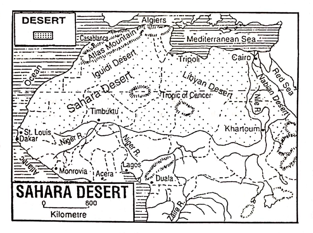
The Arabic word ‘Sahara’ means ‘desert’. The Sahara desert of Africa is not only the largest hot desert in the world but also it is the greatest of all deserts. Rocky hills, a vast expanse of sand striated by winds, folk tales of nomadic tribes walking across the desert with a caravan of camels-those are the essences of Sahara.
Location And Boundary:
The Sahara desert is located in north Africa. It extends from the Atlantic coast in the West to the Red Sea coast in the east and from Atlas mountain in the north to the Niger valley in the south.
Lybia and major parts of Egypt are located in this desert. Parts of countries like Algeria, Morocco, and Sudan. Tunisia, Spanish Sahara, Mauritania, Mali, Chad, and Niger are also included in the Sahara Desert.
Area And Extension:
The Sahara desert has an area of about 6.5 / 7 million square kilometers. The Sahara desert is so large that the whole continent of Europe or 21⁄2 Indias can fit into it. It stretches across northern Africa from the Atlantic Ocean to the Red Sea a distance of about 5600 km.
“importance of Africa in global trade and economy”
On the other hand, the breadth of the desert is about 1600 km from north to south. The average breadth of the desert is about 1270 km.
Relief Of The Sahara Desert:
The Sahara is almost a plateau desert. The average altitude is about 300 meters. The major Sahara ranges are the Ahaggar mountains of Algeria and the Tibesti massif in Lybia and Chad.
The Emi Koussi Volcano (3415 m) in the Tibesti is the highest point in the Sahara. To the northeast Quattara depression drops to 133 m below sea level.
This plateau desert region is composed of old rocks, exposed to erosion for a long time. Sand- dunes, pebbles, boulders, and bare rock stands have formed the relief of the Sahara.
Landforms of the Sahara Desert: The Sahara desert has three distinctive landforms-
- Ergs,
- Regs and,
- Hammada.
1. Ergs:
An erg is a type of arid desert with an extensive cover of sand in the form of dunes and sand sheets, especially in the Sahara.
2. Regs:
In the eastern part of the Sahara desert, all the fine materials have been blown away and the surface is covered by pebbles and boulders. This part of the Sahara desert is known as ‘reg’ in Algeria and ‘serir’ in Libya.
3. Hammada:
In some parts of the desert, an extensive flat rocky surface is exposed from which sand has been removed by the wind. This desert surface of the bare rock is known as hammada.
Rivers lakes And Oases Of the Sahara Desert
Only the river Nile in the eastern part of the Sahara and the river Niger in the western part of the desert are flowing. Most of the rivers of the Sahara originate from Atlas mountain and the Central highlands.
But their channels have dried up as the water infiltrates into the sandy bed and excessive evaporation due to very high temperature. These dry river channels are wadis.
Wadis may experience occasional flash floods after heavy desert thunderstorms. There are many large or small wadis in the Sahara. They are dry for 340 days of the year. Several wadis in the northwestern Sahara are fed by rain and snow.
Lakes :
The important lake in the Sahara is lake Chad, which lies on the borderland of the Sahara. The lakes of the Sahara have no outlet and therefore are saline. They are not suitable for irrigation.
Oases:
A place in the desert that receives enough water to allow plants and crops to grow is an oasis. The most important places in the Sahara are the bases. Some important Sahara oases are Kharga and Farafra in Egypt, Khufra in Libya, and Ghardaia in Algeria.
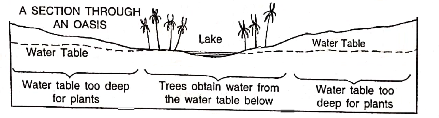
Natural Vegetation:
The scarcity of water in the desert does not support the growth of vegetation. Only drought-resistant plants like acacia, and cactus, have thorny roots and thorny leaves. Usually, around the oases, these trees grow. Various salt-tolerant plants also grow in saline low-lying areas.
Climate In The Sahara Desert:
The Sahara is an arid land. The climate of the Sahara desert is the extreme type with scorching summers (50°C-52°C) and near-freezing winters (5°C -10°C).
Sometimes the day temperature during March to June rises above 54°C and at night, the heat rapidly goes out into a cloudless atmosphere and the temperature may fall below the freezing point.
So, the range of temperature is very high. The annual average rainfall is uncertain and less than 20 cm. Rainfall, besides being scanty, is spotty and undependable. In some places, years pass away without giving a single drop of rainwater.
“practice exercises on continent of Africa WBBSE geography”
World’s highest temperature and lowest rainfall have been recorded in this region. The highest temperature recorded in Summer is 58°C (The highest temperature in the world is recorded in ‘Al-Azizia’ of Libya) A terrible sky-blanketing dust storm and the sand storm may happen in the daytime, especially in the N.
Sahara, in summer. It is known as Simoom (Simoon) in’ the Arabic or local language. A hot dry southerly wind blows across Egypt and the South Eastern. The Mediterranean area from the Sahara.
It is called Khamsin. On the Guinea coast a west African hot and often dust-laden wind blows South East. from the Sahara.
It is called Harmattan. Its dryness helps to relieve the shifting humidity as it nears the coast and thus seems a relatively cool and healthy wind in that area, hence its local name there is ‘the Doctor’.
Animals:
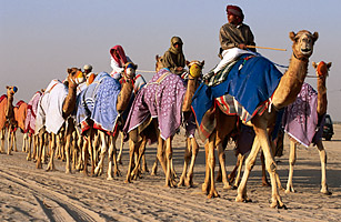
Herds of camels, flocks of sheep, and goats are found roaming in the grasslands. The most popular cattle is a camel. Of all the animals the camel is ideally fitted for life in the desert.
The padded feet, fatty, hump, fewer Sweat glands, thicker artery walls, tough mouth with a long neck, hairy skin, and large eyelashes. The ability to close its nostrils makes this animal suited to live in the desert.
When alive, the animal supplies milk and carries people and goods. When dead, its flesh can be eaten, its hide can be used for making tents and bags, and its hair for making clothes and rugs. No wonder the Arabs regard the camel as the “Greatest gift of Allah”.
Agriculture:
The scarcity of water is the most important problem of the Sahara desert. Agriculture is only possible around the oases where the groundwater level is close to the surface. cotton, wheat, barley, millet, rice, potatoes, corn, sugar cane, vegetables, watermelon, ‘dates, and other fruits are mainly cultivated.
Minerals:
Mineral oil is produced in Algeria and Libya. A little amount of coal, salt, iron- ore, and gypsum are also available in the desert.
“impact of geography on Africa’s population distribution”
Industries:
The adverse physical environment and the lack of raw materials are responsible for the industrial backwardness of this region. Only cotton and woolen textiles, oil refining and. sugar industries have developed in some places of the Sahara desert.
Transport System:
The people of the Sahara desert still make journeys of hundred of kilometers so by camel. Camels are the main ride for the inhabitants of the desert. A herd of camels moving together in a desert is referred to as a ‘Caravan’. Caravans of camels cross the deserts along regular routes which are studded with oases.
They deliver news, exchange goods, and carry dates and hides to ports and cities. However, with the extension of the Trans-Saharan railway and the construction of metalled roads, the ‘ship of the desert’ as the camel is called, is gradually giving place to mechanized transport.
Changing Scenario:
The Sahara has changed with time. Rich oil and gas fields and some iron-ore, coal, rock-salt, phosphate, zinc, lead, and manganese fields have been discovered in different parts of Algeria, Libya, and Egypt. New industries are also being set up in different areas.
Thus many former nomads and oases dwellers now flock to the mines, oil refineries, iron and steel factories, and textile mills for employment. So, the face of the Sahara and the lives of its people have been changing fast in recent years.
Population:
The Sahara desert is, actually an uninhabited region. The Sahara with about 5 million inhabitants has an extremely low density of population-less than one person per square kilometer. Two groups of people live in the Sahara such as
- The nomadic people are called Beduins, and
- Oases dwellers. The majority of the people are oases dwellers.
1. The nomadic people are the Creda, Beduins (Dwellers of the desert), Chaambas, Berbers, and Tuaregs (the people of the veil). These nomadic people mainly rear sheep, goats, and camels and move from one place to another.
“environmental issues and conservation efforts in Africa”
2. Some live in oases or on the highlands and desert margins where poor pastures are found. The larger oases have villages with their tall flat-roofed mud houses called adobes. These houses are built close together to save space.
Important Cities And Ports
Tripoli :
Tripoli is the capital, the largest city as well as the largest port of Libya.
Benghazi :
Benghazi is the second largest city and another important port in Libya. Algiers is the capital, largest city, and important port of Algeria.
Timbuktu (Mali), Awburi (Libya), Hassi Massaud, and Bechar (Algeria) are important commercial centers.