Chapter 9 Continent Of Asia
The continent of Asia is the largest and most populous continent in the world. The word Asia is derived from the word ‘Asu’. The meaning of this word is ‘east’ or ‘the land of the rising sun’. It contains 33 per cent of the world’s land surface and occupies four-fifths of the Eurasian landmass.
About 60% of the total population of the world lives here. Asia is the most diverse of all continents. The variety of landforms, rivers, climates, natural vegetation etc. is infinite on this continent.
“WBBSE class 7 geography chapter 9 notes”
The linguistic, ethnic and economic diversity of Asia is greater than that of any other continent. Politically, it has the most varied forms of government.
Asia is the cradle of some of the most ancient civilizations in the world which are associated with its long, navigable rivers é.g. the Indus valley civilizations, and the Mesopotamian civilization of the Tigris.
Euphrates and the Chinese civilization of the rivers Hwang-Ho, Yangtze-Kiang and Si-Kiang.
Read and Learn More WBBSE Notes for Class 7 Middle Class Geography
Asia because of its size, location, extent, and relief is characterized by contrasts in its climate, natural vegetation and other geographical factors and hence is spoken of as the Continent of Contrasts. Asia is also known as the Continent of Extremes.
Location:
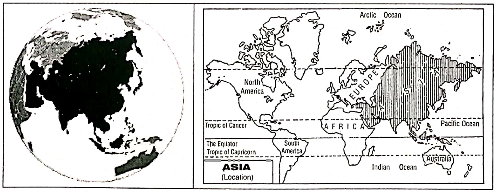
The continent of Asia mainly occupies the northern part of the Eastern Hemisphere.
In latitude, it extends from nearly 82° North to nearly 10° South and in longitude from 26°04′ East to 169°40′ West approximately, if the Cape Chelyuskin Island and Severnaya in the Arctic Ocean and the South-East Malaysian-Indonesian Archipelago are included.
“continent of Asia WBBSE class 7 geography notes”
It extends over a latitudinal range of 92° from North to South and a longitudinal range of about 165°.
Chapter 9 Continent Of Asia Boundary
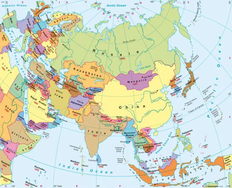
The continent is bounded on the north by the Arctic Ocean, and on the east by the Pacific Ocean and its associated seas. On the west Asia and Europe form a continuous landmass and the boundary between them is rather difficult to define.
It is marked by approximately the crest of the Ural Mountains, the Ural River, the Caspian Sea and the Caucasus Mountains.
Then it continues southward. the Black Sea, the Sea of Marmara, and the Aegean Sea. The country of Turkey lies partly in Europe (7%) and (93%) in Asia, on both sides of the narrow Straits-the Bosphorus and Dardanelles.
One-third of Russia (CIS) lies in Europe and the rest in Asia. Along the coast of Asia Minor (Turkey) with the Mediterranean Coast of the Levant forming Asia’s Western limits.
In the South of Asia lies the Indian Ocean and the associated Seas. Asia was connected with the continents of Africa by the Isthmus of Suez separating the Red Sea from the Mediterranean Sea.
“exercise 9 solved questions on continent of Asia class 7”
In 1869, a Canal, known as the ‘Suez Canal’ was cut through this isthmus; this joined the Mediterranean to the Red Sea and separated Asia from Africa.
In the northeast corner lies the Bering Strait between Asia and North America. Except New Guinea and the Aru Islands which belong to Oceania, the island of east India is considered as part of Asia.
Area:
The total area covered by Asia is about 44579000 sq. km. This is almost one-third of the total landmass of the world. It is one-seventh larger than the two Americas together, twice as big as Africa and four times the size of Europe.
Extension:
The maximum length is 10780 km and the greatest width is 8530 km. The mainland of Asia is so compact that a considerable area in the central part of the continent is more than 2400 km away from the nearest Sea Coast.
“WBBSE class 7 geography chapter 9 important questions”
Population:
Asia is the most populated continent in the world. These are nearly 417 crores of people (4164252000) (July 2011). 60% of the total population of the world lives here.
Chapter 9 Continent Of Asia Geographical Importance Of Asia
Asia is a typical continent exhibiting different types of natural and socio-cultural features. Some major features are described below:
- The largest continent of the world Asia is a vast continent with an area of about one-third of the earth’s surface.
- Asia has been the cradle of many ancient (around 3500 5000 B.C.) civilizations such as Mesopotamian, Indus valley and the Chinese. Civilizations associated with its ancient River Valleys. These civilizations flourished on the banks of the river such as Tigris, Euphrates, Indus, Hwang-Ho and Yangtze-Kiang.
- Asia and Europe though two continents are in fact one homogeneous landmass. A part of this undivided greater landmass is called ‘Eurasia’.
- The continent is so vast, that when the sun rises in the west, then the sun almost sets in the extreme east.
- This continent is different from others in respect of the nation, religion, caste, art and culture, human race and different things.
- World’s first civilizations, city-states, Kingdoms, empires and isolated village hamlets developed on this continent.
- All the world’s greatest religions began in Asia. These include Hinduism, Judaism, Christianity, Islam, Buddhism, Confucianism, Shinto and Zoroastrianism.
- The variety of landforms is infinite on the continent.
- The assembly of significantly high peaks is not found in any other part of the world.
- Asia contains a large number of rivers. Of the world’s ten longest rivers six are in Asia.
- There is an extreme variety of climates in different parts of the continent.
- All types of natural vegetation grow in Asia.
- Asia has two of the world’s most populous countries – China and India and most of the people (60%) of the world live in Asia.
- The greatest diversity in race, religion and culture and political systems of Government is to be found in Asia.
- Different types of power resources are found in Asia.
- This continent is rich in many types of mineral resources, such as coal, iron ore, bauxite, mica, petroleum etc.
Asia is also developed in agriculture and industries. The linguistic, ethnic and economic diversity of Asia is greater than that of any other continent.
“physical features of Asia class 7 geography”
Chapter 9 Continent Of Asia Continent Of Extremes
Asia is known as the ‘Continent of Extremes’ because there are some specific extreme characteristics found in Asia.
Asia is the largest continent in the world. It is also the most populated continent in the world. The highest mountain (in the Himalayas), highest mountain peak (Mt. Everest 8848 m),.
highest plateaus (The Pamir, ‘Roof of the world’), the largest high plateau Tibet, the largest lake in the world (Caspian Sea), the deepest lake in the world (Baikal), the lowest point of the land surface (Elghar valley of the Dead sea which is 393 m), coldest place (Verkhoyansk,- 56°C).
The Omiyakon in Siberia – 72° C, one of the hottest places in the world (Jacobabad; 52°C), the rainiest Cherapunji area (Mowsynram, 1254 cm), the largest peninsula in the world (Arabian Peninsula, 3250000 sq. Km) and the largest strait in the world (Malacca), the largest continental shelf (the Sunda platform), the deepest trench Mindanao Deep (Mariana trench – 11034 m)-all are situated in Asia. Such extremes make the continent of Asia the ‘Continent of Extremes’.
Continent Of Contrast
Asia, because of its size. location, extent and relief are characterised by contrasts in its climate, natural vegetation and other geographical features, Asia has rightly been called the ‘Continent of Contrasts’.
- Asia has the highest mountain peak in the world (Mt. Everest, 8848 m.) and the lowest part of the earth’s land surface (the Elghar valley of the Dead Sea – 393 m.)
- The deepest lake Baikal and the deepest trench Mariana are also situated here. It has the lowest record of temperature on the earth’s surface of Verkhoyansk (- 56°C) in North-East Siberia. In contrast, Jacobabad in the Desert of Pakistan is one of the hottest places in the world (52°C).
- Asia has the highest annual rainfall in the world at Mowsynram on Cherapunji, Meghalaya, 1254 cm. (approximately), while most of the tropical and mid-latitude deserts, which are rather extensive, get less than 25 cm.
- It has practically every type of climatic belt and is consequent by natural vegetation varies from mass and lichen of the Tundra to the dense tropical/equatorial rain forest or coniferous forest of Taiga.
- Population density is not equal in all areas of the continent of Asia. High population density areas (fertile valleys) present a sharp contrast with vast sparse or uninhabited areas (Déserts etc.)
- On the one side of this continent fertile river valleys are available on the other side there are barren lands in the central and western parts of the continent.
- Russia, which has a large extent in Asia, is the world’s largest country, while Maldives, Bahrain and Singapore are small countries having an area of less than 1000 km. each.
- Japan, S.Korea, Singapore, Taiwan etc. produce electronic and high-tech goods like computers, cameras and hi-fi equipment. Traditional industries and methods of working are still important to less industrialized nations e.g. India, Bangladesh, Vietnam etc.
- The political, religious, linguistic, ethnic and economic density of Asia is greater than that of any other continent.
- Asian living standards differ greatly. The industrial wealth of Japan and the oil wealth of the Gulf states of S.W. Asia contrast sharply with some of the poorest of this continent.
All the above factors clearly establish Asia as the ‘Continent of Contrasts’.
“major mountain ranges and rivers in Asia WBBSE”
Chapter 9 Continent Of Asia Physiographical Or Topographical Features Of Asia
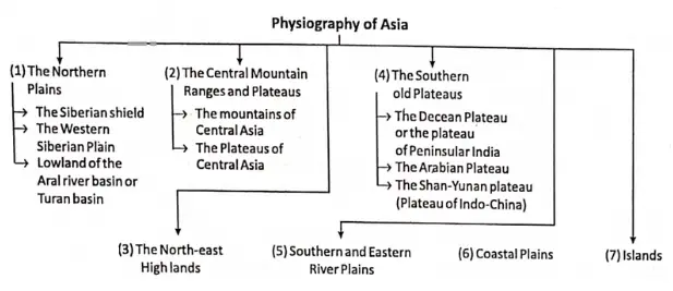
Asia is a vast continent which represents all the major landforms. On the basis of physiography, Asia is divided into seven divisions. They are as follows:
- The Great Lowland Triangle Of The North-west Or The Northern Plains,
- The Central Mountain Ranges And High Plateaus,
- The North-East Highlands,
- The Southern Old Plateaus,
- Southern And Eastern River Plains,
- Coastal Plains And
- Islands.
The Great Lowland Triangle Of The North-West Or The Northern Plains
The Northern part of the continent of Asia has a triangular-shaped plain of extensive flat land which occupies almost 40% of the continent.
It stretches from the Ural Mountain and the Caspian Sea in the west and southwest to the Yablonoy, Stanovoy and Verkhoyansk Mountains in the northeast. This northern plain of Asia is the largest plain in the world.
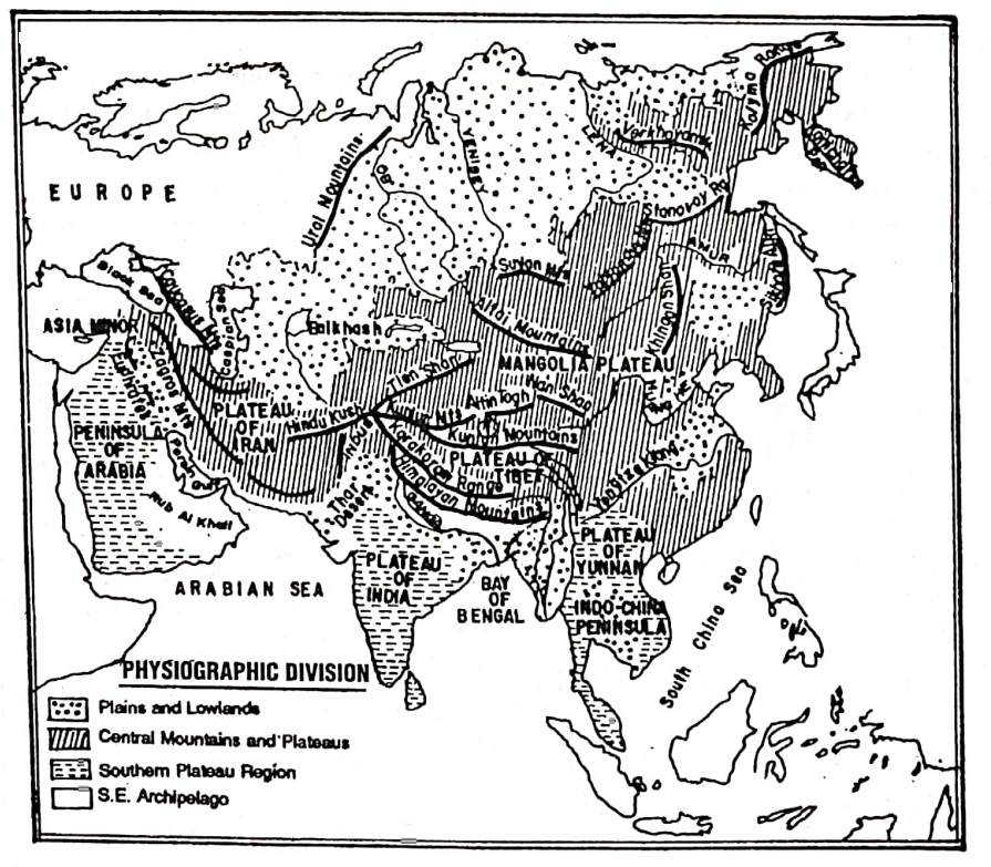
This extensive region can be further divided into three parts. They are-
- Siberian Shield,
- The Western Siberian Plain And
- Lowlands Of The Ural River Or Turan Basin.
Siberian Shield:
The Siberian shield stretches from the Bering strait in the east to the banks of the Yenisey river in the west. It is a very ancient and denuded surface which is formed due to the gradual erosion of old plateaus.
The Western Siberian Plain:
It stretches from the valley of the Yenisey river in the east to the western boundary of Asia in the west. The average height of the plain is 200 m. In this region between the Ob and the Yenisey rivers lies an extensive marshy lowland.
Lowlands Of Turan Basin:
The lowlands in the Southwestern parts of the northern plains, an area of inland drainage, the Amu Darya and the Syr Darya. Both of them flow to the Aral Sea, and other to the Caspian Sea.
The Central Mountain Ranges And Plateaus
At the continent’s heart or nearly the centre of Asia lies a convergence of the world’s mightiest mountains, like the Himalayas, Karakoram, Hindu Kush, Kunlun etc. So, Asia is also called the ‘Mountain hearted continent’.
In between the mountains be some famous plateaus. Most of the mountains extend from two centres or knots called
- Pamir Knot And
- Armenian Knot.
Pamir Knot:
The vast mountain system of Asia meets at the Pamir knot. To the north of Jammu and Kashmir state of India lies the world’s highest plateau-the Pamir
Nearly 4800 m high the Pamir is also called the ‘Roof of the world’ because it comprises a great mass of mountains with lofty plateaus (3600 – 4200 m).
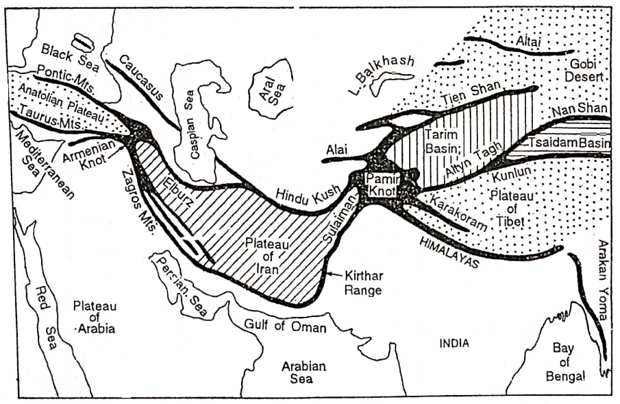
As the roof is the highest flat surface of a building so also the highest flat surface or plateau. on the Earth is the Pamir and hence is so-called. Most of the main mountain ranges of Asia. radiates long distances from the Pamir Plateau, so it is also called the ‘Pamir Knot’.
South-east of the Pamir extends the Himalayan Range. Himalaya is the largest and highest mountain in the world.
Mt. Everest is the highest peak in the Himalayas (8848 m) and also the >world. Further North of the Himalayas lies the Karakoram Mountain range. The highest peak of the Karakoram range is Godwin Austin or K2 (King of Karakoram).
“climate and vegetation of Asia class 7 notes”
It is the 2nd highest peak in the world (8611 m). East from the Pamir extends the Kunlun, Altyn Tagh, Nan-shan, Siniling- shan and Khingan Mountains.
Stretching northeast from the Pamir, extend the Tien-shan, Altai, Sayan, Yablonovoy and Stanovoy Mountain ranges. West of the Pamir extends the Hindu Kush mountain range and South-west of the Pamir knot extends the Sulaiman and Kirthar mountain ranges.
Further west it forms the Zagros mountain which merges with the Armenian Knot.
Armenian Knot:
This plateau or knot is located to the southeast of the Black Sea. To the east of this knot extend two mountains-Zagros and Elburz and to the North-west of this knot extend two Mountains-Pontic and Tauras.
Between these two ranges lies the Anatolia Plateau, called ‘Asia Minor’. The Caucasus range belongs to Europe.
The Central Asiatic Plateaus:
The vast plateaus lie between the folding mountains and the northern plains. The plateaus of outstanding importance are as follows.
The Plateau Of Tibet:
This is the largest plateau in the world and it is surrounded by great Himalayas to the south and Kunlun to the north.
The Plateaus Surrounding The Tarim Or Sikiang Basin:
The Tarim basin is one of the driest basins in the world. It is surrounded by Tien Shan to the north and Altyn Tagh to the south. This basin is largely occupied by the Takla Makan Desert.
The Tsaidan Basin:
This basin lies between Kunlun in the south and Nanshan in the north.
The Plateau Of Gobi Or Mongolia :
This plateau is a stony desert and lies between Altai and Nanshan ranges the average height varies from 1000 metres to 1500 metres above sea level.
Plateau Of Iran:
This plateau covers really whole of Iran. It is situated between Elburz and the Hindu Kush to the north and Zagros to the south.
Plateau Of Anatolia:
The plateau of Anatolia lies in the central part of Turkey. It is bounded by Pontic to the north and Tauras to the south.
The Sistan Plateau:
The Sistan Plateau of Afghanistan lies between the Hindu Kush Mountain in the north and the Sulaiman Mountain in the south.
The plateau of central Asia is surrounded by mountains so most of them are dry with little vegetation, i.e. nearly like deserts or actual deserts. This area is also called the “Dead Heart of Asia”.
The North-East Highlands
It is mainly a highland region including high ranges around the Verkhoyansk and Kolyma tablelands. The Mountains of Kamchatka and Sakhalin constitute comparatively young parts of the Pacific ocean mountain belt.
They have numerous extinct active volcanoes. The mountainous islands of Kuril Arc are an extension of the Kamchatka mountains.
The northeastern highland region can be traced even to the isolated ranges north of the Tien-Shan. There are the Yablonoi-Stanovai and the extensive Altai-Sayan mountain stand.
Along the southern shore of Lake Baikal lie the Sayan mountains. The ranges of the east are the Khingan mountains and the Shanshi highlands.
The Southern Old Plateaus
The old plateaus of South Asia can be divided into three sections-
- The Plateau of the Arabian Peninsula,
- The Deccan Plateau of Peninsula India and
- The Plateau of Indo-China or the Shan-Yunan plateau.
The Plateau Of Arabian Peninsula :
The Arabian Plateau is situated in South-west Asia. This plateau is not much broken up. Its steep edge lies on the west towards the Red Sea.
It slopes on the northeast towards the Tigris-Euphrates valleys. The whole region is dry and it is entirely a desert land without lakes and rivers.
The Deccan Plateau Of Peninsular India:
It is the oldest part of Asia and one of the most stable landmasses in the world. The whole terrain is made up of several large or small plateaus forming into a dissected plateau.
The undulating surfaces with broad, rounded summits seldom rise above 600 m. constitute important physiographic uniqueness of the area.
The-Shan-Yunan Plateau Or The Plateau Of Indo-China:
It includes parts of the Shan state of Myanmar and the Yunan state of China. Towards the south, it extends up to the Malayan peninsula. It is, a dissected plateau broken by the rivers like Salween, Mekong and Upper Yangtze.
Southern and Eastern Alluvial River Plains
The great lowlands of Eastern Asia and Southern Asia are mainly the river plains or the alluvial plains. These plains are fertile and the most densely populated areas. Some of the most important river valleys are as follows:
- The Indo-Gangetic plain of India,
- The Tigris-Euphrates valley plain of Iraq,
- The Irrawaddy Basin of Myanmar,
- Menam valley of Thailand and
- Mekong valley of Cambodia and Vietnam,
- The Hwang-Ho, Yangtze-Kiang and Si-Kiang valleys of China and
- The Amur valley.
Coastal Plains
Asia is bounded by the Arctic Ocean to the north, the Pacific Ocean to the last and the Indian Ocean to the South and has numerous seas, bays and gulfs which are of strategic importance.
To the northeast and south, this continent has coastal plains that vary from being very broad in some places while at others it is narrow. Many places are fertile and cultivable but some parts are salty and sandy. So these plains are not suitable for cultivation.
Islands
Asia has a large number of islands. There are some isolated islands and some groups of islands in the Pacific Ocean in the east and south-east of Asia like-
- The Japanese Islands,
- The Philippine islands,
- The Indonesian islands,
- The Malaysian islands (Malay, Sarawak, Sabah, and Singapore).
Chapter 9 Continent Of Asia River Of Aisa
The continent of Asia contains a large number of rivers. Of the world’s ten longest rivers, six are in Asia. The characteristic features of the rivers or drainage system of Asia are as follows:
- Most of the rivers of Asia rise from the extensive mountain regions in central Asia.
- Many rivers also rise from the plateau of the south but they are comparatively smaller.
- These rivers are snow-fed and rain-fed. Some tidal rivers are found in the coastal areas.
- There are many perennial rivers and non-perennial rivers. Generally, snow-fed rivers are perennial and rain-fed rivers are non-perennial.
- These rivers flow in many directions according to the slope of the land, but as we will see this is not always the case with the Asian landscape. The Himalayan rivers actually cross the Himalayas in deep Gorges and flow at right angles to the cross-section.
- The rivers form a pattern of drainage network which is strongly influenced by geological structure.
- Most of the rivers of Asia either flow to any of the Arctic, Pacific and Indian oceans or internal depressions.
- The rivers of Japan are short and swift and are helpful for the production of hydro. electricity.
- The rivers give rise to fertile valleys.
- A number of river-based civilizations developed in the large river valleys of Asia. According to their direction of flow rivers of Asia may be grouped into the following categories:
Important Rivers Of Asia
| Type of the Rivers | Name of the Rivers |
| 1. North-flowing Rivers | Ob, Yenesei, Lena, Khatanga, Kolyma |
| 2. East-flowing Rivers | Amur, Hwang Ho, Yangtze-kiang, Si-kiang |
| 3. South-flowing Rivers | The Ganges, Brahmaputra, Indus, Mekong, Menam, Irrawaddy, Tigris, Euphrates |
| 4. Inland Rivers | Amu Darya, Syr Darya, Alli, Tarim, Ural, Luni, Helmond, Jordon |
| 5. Wesfflowing Rivers Narmada, Tapi | Narmada, Tapi |
North Flowing River
Ob, Yenesei, Khatanga, Kolyma etc. are the main river falling into the Arctic Ocean. The characteristics of these rivers are as follows:
- These rivers rise from the mountains in central Asia and flow to the north.
- The mountains of these rivers are located in the Frizid zone. So, they are covered by ice for nearly 8 to 9 months in a year.
- Floods occur often in the middle and lower courses of these rivers.
- A number of marshlands are found in these river basins.
- The navigability of these rivers is poor. So, these rivers are not much used for navigation.
- These river basins are sparsely populated.
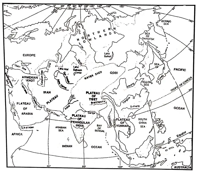
Ob:
The mainstream of the Ob (3677 km long, with Irtish 5570 km long) rises in the Great Altai Mountains and flows to the north. The Irtish, its principal tributary, is longer than the mainstream before their confluence.
Ob along with Irtish is the 2nd longest river in Asia. The river flows very sluggishly over the flat West Siberian Plain and falls into the Arctic Ocean (the Gulf of Ob).
Yenesei:
Yenesei (5540 km) is coming out from the Sayan Mountains flows towards. north and falls into the Arctic Ocean (Yenesei Gulf). Its main tributary is the Tungaska. Yenesei is the 2nd longest river in Asia and the 5th longest river in the world.
Lena:
Lena (4270 km), rises from the mountains adjacent to Lake Baikal and flows to the north into the Arctic Ocean (Laptevic Sea). Vitim and Aldan are its two main tributaries.
Khatanga:
It is coming out from the Sredne Highland, flows north and falls into the Arctic Ocean. Kheta is its main tributary.
Kolyma:
It is coming out from Khrebet Cherakogo (Gida Mountains) high land flows north and falls into the Arctic Sea. Omoloki is its main tributary.
East Flowing Rivers
The Amur, Hwang-Ho, Yangtze-Kiang and Si-Kiang etc. are the main rivers of Asia that flow to the east and drain into the Pacific Ocean at different parts. The characteristics of these rivers are as follows:
- These rivers rise from the central Mountain area and Plateau region and flow into the Pacific ocean.
- These rivers are perennial and carry a large volume of water. These rivers have a long plateau course.
- Deep Gorges are found in the mountainous courses of these rivers.
- The Principal rivers have rapids in their plateau course. This impairs the navigation of the rivers.
- The rivers have formed depositional plains rich in the alluvium in their lower courses.
- These rivers are navigable and they play an important role in the transportation system.
- Most of the river basins are densely populated.
The Amur (4440 km):
The Amur coming out from the Yablonoy Mountains flows towards the east and falls into the Pacific Ocean (Okhtosk sea).
The Hwang-Ho (5460 km):
It rises from the north of the Bayanhar Mountains lie in the Ching-hi state of China and flows to the east and falls into the Pacific Ocean (the Bay of Po-hai). Large amounts of less are lifted from the Gobi desert of Mongolia and deposited in the Hwang-Ho river by the wind.
The loess is yellow in colour and when carried by the Hwang-Ho, the river looks yellow. Therefore the Hwang-Ho is also called the ‘Yellow River’. The river was known as the ‘Sorrow of China’ as it used to create floods each and every year.
But now it is not all known as the ‘Sorrow of China’. The river has been dumped in several places and thereby providing irrigation facilities to a vast region. Its main tributaries Phen-Ho and Wei.
The Yangtze-Kiang:
Yangtze-Kiang is the longest river 5590 km/6300 km in China. It is also the longest river in Asia as well as the third longest river in the world: Yangtze-Kiang means, the ‘son of the ocean’.
It is also known as the river of ‘Golden Dust’. It is coming from the Geladangdong mountain peak in the south of Kunlun mountain flows towards the east and falls into the Pacific Ocean (North China Sea).
The Si-Kiang (2340 km):
The Si-Kiang rises from the Umang mountain region of the Yunan plateau (Yunan Province of China). It flows towards the east and finally falls into the South China Sea. Peikiang is its main tributary.
The lower course of this river is known as the Canton river as the 2nd largest city and port in China, Canton is situated on the bank of the river. The river is also known as the ‘Pearl river’ in China.
South-Flowing Rivers
The Ganges, Brahmaputra, Indus, Mekong, Menam, and Irrawaddy. Tigris, Euphrates etc. are famous rivers. The characteristics of these rivers are as follows:
- Most of the rivers, except the Tigris and Euphrates, originate in the Mountains and flow through the monsoon climatic region.
- These rivers are fed by both snow/ice melt water and rainwater.
- These rivers’ valleys are very fertile.
- These rivers are navigable and suitable for irrigational purposes.
- In the lower course of the rivers flooding occurs in the rainy season.
- Most of these river valleys have a dense population.
The Ganges (2510 km):
The Ganges is the longest river in India. It rises from the Gangotri Glacier of the Himalayas. It is the confluence of two river-Alakananda and Bhagirathi. The combined river cuts through the Himalayan Ranges and debouches to the plain near Hardwar.
It then flows southeast through the north Indian plain and finally divides into two branches near Rajmahal hill. The main eastern branch (the Padma) enters Bangladesh and the slender western branch (the Bhagirathi) flows through West Bengal and falls into the Bay of Bengal near Sagar Island.
The main tributary of the Ganges is Yamuna. The Ganges- Brahmaputra Delta is the largest delta in the world.
Brahmputra (2580 km):
It rises from the Chemaung-dung glacier of the Tibetan plateau. flows towards the cast. Around Namcha Barwa the river turns southwards, enters India and then turns westwards.
To the west of the Meghalaya plateau, it again turns southwards to meet the Ganges near its mouth before entering the Bay of Bengal. Majuli Island in the River Brahmaputra is the largest river island in the world.
The Indus (2880 km):
It rises near Manas Sarovar lake in Tibet and then flows to the northwest and around Nanga Parbat, it turns to the southwest to finally drain into the Arabian Sea. Its main tributaries are Jhelum, Chenab, Ravi, Sutlej, Beas etc.
Mekong (4350 km):
It is the main river of Indo-China. It rises from the southern slopes of the Kunlun mountains and flows along the eastern boundary of Thailand before draining into the South China Sea.
Menam (365 km):
The river rises from the Shan plateau of Myanmar and flows to the south into the Gulf of Siam.
Irrawaddy (2090 km):
The river rises from the northern highland of Myanmar flows towards the south and falls into the gulf of Martaban. It is the main river of Myanmar. The main tributary of this river is Chindwin.
Tigrese (900 km) And Euphrates (2780 km):
These two rivers are rising from the Armenian plateau, and flow south through Iran and Iraq. The joint flow of these two rivers is known as ‘Sat-el Arab’ and then flows into the Gulf of Persia.
Inland Rivers
There are some inland rivers in Asia. Among these rivers Amu Darya, Syr Darya, Illi, Tarim, Ural, Jordon, Helmond, and Luni are mentionable. The characteristics of these rivers are as follows:
- The rivers do not drain into seas and oceans.
- They end their journey in inland water bodies such as the Caspian sea (Lake) and Aral Lake.
- Northwest in Central Highland of Asia lies in the huge area of inland drainage.
- These rivers do not hold much water due to scanty rainfall in their catchment areas.
Amu Darya ind Syr Darya :
These two rivers are coming out from the Pamir plateau flow towards the northwest and fall into the Aral Sea.
IIIi:
It is rising in the Tien Shan Mountain region flows north and falls into the Balkhas Lake.
Tarím 1600 km:
The Tarim river is the world’s largest inland river. It rises from Karakoram Mountain and falls into Lop Nor Lake. This river has formed the Tarim basin. It is a non-perennial river.
“population and cultural diversity in Asia WBBSE”
The Ural:
It rises in the Ural mountains flows towards the south and falls into the Caspian Sea. The Helmond: The Helmond river rises in the Hazaragat Highland in Afghanistan flows towards the west and falls into the Hanun-I-Helmond Lake.
The Jordon:
Jordon is a small river. It rises from the Lebanon Highland flows through Jordon Valley and falls into the Dead Sea. This river remains dry throughout the year because of Scanty rainfall.
Luni :
This river is coming out from the Ana Sagar Lake of Aravalli Mt. flows towards the southwest and falls into the Rann of Kutch.
West-Flowing Rivers
There are few major west-flowing rivers in Asia. Among them the Narmada and the Tapti (Tapi) are noteworthy.
Lakes Of Asia:
There are numerous lakes and marshes in Asia. Among them, some lakes have fresh water that is drinkable while others have salt water.
Freshwater Lakes In Asia:
The largest freshwater lake in Asia is Lake Baikal (Baykol) in Russia. It is the world’s deepest lake (1637 m below sea level). The other freshwater lakes are Manas Sarovar in Tibet, Dal and Wuler lake in Jammu and Kashmir, Nainital, in India, and Beuya Lake in Japan.
Saltwater Lakes In Asia:
The Caspian Sea (The largest lake in the world), Aral Sea, Balkhas, Dead Sea, Lop Nor (China), the Van lake of Turkey etc.
Chapter 9 Continent Of Asia Climate Of Asia
The climate is a very important element of the natural environment. The continent of Asia is so large that almost all the climatic types of the world are found here.
Causes or Factors of Diversity of the Climate in Asia: Enormous size, shape, compactness, range of latitude, latitude and alignment of mountains, direction of winds, and ocean currents combine to produce great climatic contrasts in Asia.
Factors affecting the climate of Asia are as follows:
- Latitudinal factors,
- Altitudinal factors,
- Continental factors,
- Influence of wind,
- Ocean current,
- Presence of Topography or Mountains,
- Distance from the Sea.
1. Latitudinal Factor:
The continent of Asia lies between 82°N and 10°S latitude. The latitudinal range is 92°.
So the northern part of this continent is in the Arctic or north polar region (Frizid zone), the central part is in the Northern temperate zone and the southern part (Equatorial region) is in the torrid zone. Sun’s rays are oblique as we move away from the Equator.
As a result of average annual temperature gradually decreases from the Equator towards the Poles.
2. Altitudinal Factor:
Temperature decreases at a rate of 6.4°C with every 1000 m or 1 km rise in altitude. The average altitude of the Central Highlands of Asia is more than 4000 m High. So there is a difference in temperature in the lofty peak region and base region of a mountain.
3. Continental Location Or Distance From The Sea/Ocean:
One-third of this continent is nearly 1000 km from the sea and some part is near about 2400 km from the nearest sea coast.
The moderating influence of the sea does not reach the interior of the continent, so extensive areas in the central region have extreme climates.
“natural resources and industries in Asia class 7”
4. Topogrophy/Presence Of Mountains And Plateau:
High mountains of this continent remain covered with snow and the intermontane plateau experienced extreme climate
For example, the great Himalayan Mountains act as a barrier to the influx of cold north wind to South Asia and the warm, rain-bearing south or south-west winds to the heart of Asia.
5. Direction Of wind:
Directions of winds are particularly important in Asia. In summer moist monsoon winds from the south come from the Indian Ocean and give plenty of rainfall to the southern region of Asia.
In winter the monsoon winds outflowing from land to sea are dry and cause Asia to be rather rainless.
6. Ocean Current:
According to the high latitudes that cross the northeastern coast of Asia, the region should have a cold climate.
But the warm ‘Kuroshio’ ocean currents flow along the shores of the area, so this part of Asia has a temperate climate occurring over the region.
Chapter 9 Continent Of Asia Characteristics Of Asian Climate
- The continent of Asia is stretching from the north. The northern part of this continent is in the north polar region, the central part is in the northern temperate zone and the southern part is in the torrid zones.
- One-third of this continent is nearly 1000 km away from the sea and some part is near about 2400 km away from the sea. This region is experienced extreme climate.
- High mountains and their lofty peaks this continent remain covered with snow and the intermontane plateaus experienced extreme climate.
- The southern and central parts of this continent have huge mountains. So there is a difference in temperature and rainfall here.
- The coastal region of this continent is influenced by ocean currents.
- The influence of two monsoon winds (North-East and South-West) is particularly important in Asia.
- The presence of forests also influences the climate of Asia.
- One of the hottest and the coldest part of the world are situated here Jacobabad (Pakistan) is one of the hottest places and Verkhoyansk (Russia) is one of the coldest parts of the world.
Chapter 9 Continent Of Asia Seasonal Conditions Of The Important Elements Of Climate In Different Parts Of Asia
Temperature:
In summer temperatures are very high from Arabia in the west to the northwest of India in the east. Temperatures vary from 32°C-38°C in the region in July.
The average temperature in the summer season in the un limit of Asia is 7°C on average. The southern part of Asia has the highest temperature in winter.
In January the temperature varies between 20° to 27°C. Further north temperature decrease In Siberia and far east at many places temperature fall below freezing point in January -30° to 40°C.
Air Pressure And Winds:
Extremely high temperature in summer in the tropical region, especially in northwest India creates a severe low-pressure belt over the region.
During the same season, there is high pressure over the India ocean, so winds carry plenty of water vapour from above the ocean and move into the low pressure over the northwest of India.
During winter the extreme cold in central and northern Asia causes high pressure over the region. Cold and dry winds then move from this high pressure in central and northern Asia to move to the low pressure in the south and east.
Rainfall:
During summer the monsoon winds blowing from the Indian and pacific ocean towards the mountain region of central Asia are moist and causes abundant rainfall in Southeast Asia (including India and China).
“major countries and capitals of Asia WBBSE geography”
Rainfall is over 100 cm on average. The highest annual rainfall. in the world occurs in India in the state of Meghalaya at Mowsynram near Cherapunji.
It is nearly 1250 cm. Central Asia is surrounded by mountains, and the plateaus in the centre receive the least rainfall, 25 cm on average.
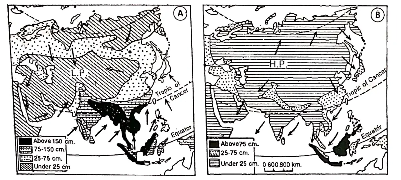
In winter the winds blow from land to sea. These winds are dry since they blow from the land. So most of Asia receives very little rain in the cold season except the west.
“chapter 9 continent of Asia long and short questions”
Being situated in the equatorial region temperature and rainfall over the East Indies (Malaysia and Indonesia) remain uniformly high throughout the year.
Some rain occurs along the Mediterranean coast and the influence of westerly winds. In Japan, the southeast coast of India northwest India etc. receives some rain.
Chapter 9 Continent Of Asia Climatic Regions Of Asia
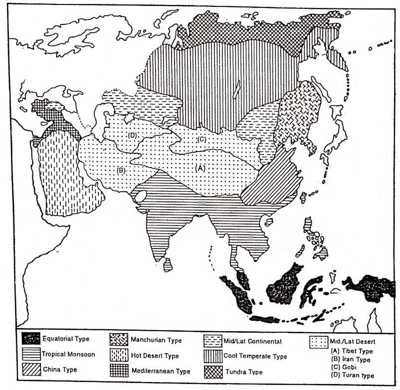
| Climatic Type/Region | Location | Characteristics |
| 1.Equatorial climate. | The Equatorial type of climate is located between 5° S to 5° N parallels of latitude. It is observed in different countries of Asia such as Maldives, Sri Lanka, Singapore, Indonesia etc. | 1. Hot and Humid climate, 2. High-temperature throughout the year as the Sun’s rays fall vertically. 3. Very low-temperature range between 2 and 3° C. 4. Average annual temperature is in between 25° to 30° C. 5. Conventional type of rainfall occurs every afternoon throughout the year. Annual rainfall is 200 to 250 cm. 6. On account of marine location temper nature remains uniform deviating little from 27° C and is well distributed |
| 2. Tropical Monsoon climate. | This type of climatic region covers India, Bangladesh, Pakistan, and Myanmar. Laos Cambodia, Vietnam, Southern China and Japan. | 1. This type of climate is greatly influenced by 2-monsoon winds. 2. An important characteristic of this climate is the cycle of seasons. 3. Summers are hot and humid while winters are mild and dry. 4. Summer temperatures vary between 30°C – 32° C while in winter they are 18°C- 22°C. 5. Annual rainfall varies from 100 to 200 cm. |
| 3. Warm temperature or Type of climate. | This type of climate is found in the north and central parts of China and in some parts of South Korea and Japan. Warm temperate or China type of climate. | 1. Summers are mild with an average temperature being 27° C. 2. Winters are quite cold with temperatures between 4°C to 12° C. 3. Snowfall occurs in some places. 4. Summers are moist and winters are dry. 5. Annual rainfall on average is about 100cm occurs in summer due to Monsoon. 6. In summer typhoons or severe cyclones cause rainfall. |
| 4. Manchurian type of climate. | It extends over Manchuria to North and South Korea, Sakhalin. the island of Russia and the northern part | 1. Milder summers and more severe winters than China’s type of climate. 2. Moderate rainfall occurs in summer. 3. Sufficient snowfall occurs In winter. |
| 5. Hot Desert type of climate | The Tropical hot deserts type of climate is found in Saudi Arabia. Iran. Iraq. Pakistan. India (Thar) etc. | 1. The summers are dry and hot. 2. Sometimes temperature rises 48° to 5o°c. 3. Range of temperature is very high. 4. Rainfall is very scanty and less than 25 cm. |
| 6. Mid-Latitude Desert type of climate. In Asia, this type of climate is further divided into the following groups: 1. Tibet type. 2. Iran type. 3.Gobi type 4.Turan type | 1. Tibet’s type of climate is found on the plateau of Tibet, 2. Iran’s type of climate is found in the enclosed of Iran. 3. Gobi-type climate is found in the Gobi desert and desert area of Tibetan Highlands. 4. Turan-type climate is found mainly in southwest Siberian lowlands around the Aral Sea and Afghanistan. | 1. Summers and hot and dry, Temperature often reaches up to 37° C. 2. Winters are cold. 3. The annual and diurnal ranges of temperature are high. 4. The rainfall is very scanty. So mid-latitude deserts are found in continental interiors. 5. The rainfall occurs mainly in early summer and spring. 6. Amount of rainfall is about 30 cm |
| 7. Mediterranean type of climate. | This type of climate is found In Turkey, Syria, Lebanon Jordon, Israel, and parts of Iran and Iraq. | 1. The main characteristics of this climate are dry summer and wet winter. 2. Cyclonic rainfall ISO cm to 100 cm) are common. 3. Temperature varies from 20°C to 28°C. The range of temperature is not high. Day temperature sometimes exceeds 32°C. The temperature drops sharply at night because of the clear sky. 4. The long summer days have clear blue skies. |
| 8. Continental type of climate. This region comprises steppes and west Manchurian type of climatic regions. | It includes all the plateaus of central Asia surrounded by mountains {the Anatolian plateau in the west, the Kirghiz arc in the middle and the Gobi desert in the east. | 1. Short duration of summer and long duration of winter are the main characteristics of this climate. 2. The annual and diurnal range of temperature is very high. 3. Some rainfall occurs in summer and snowfall occurs in winter. 4. The amount of rainfall ranges from 25 to 75 cm. |
| 9. Cold-Temperate or the Taiga type of climate. | This type of climate is found between Tundra to the north and Steppe to the south in a narrow belt, also known as a Siberian type of climatic region. | 1. In this region winters are very severe and prolonged particularly in Siberia where the temperature is below the freezing point. 2. Summers are pleasantly warm and the average temperature is about 18°C. It rises occasionally up to 35°C and 40°C. 3. This causes a very high range of temperature. 4. The rainfall is scanty, between 30 cm to 60 cm. 5. Winters face heavy snowfall and frozen lakes and rivers. 6. On the whole winters are long and cold and summers are short and warm. |
| lO.Tundra type of climate. | In the northern border of Asia, north of the Arctic circle (66½° North) this climate occurs. The region lies in Russia. | 1. Winters are long and very severe with a long duration of darkness while the summers are brief and cool (O°- 10°C). 2. Then winters bring Icy cold winds (blizzards) and so it is very cold. 3. Annual rainfall, though a major amount in the form of snow is about 25 – 30 cm. |
| 11. Mountainous type of climate. | This type of climate is found in the central highlands of Asia. | 1. Temperature decreases with increasing altitude. 2. Rainfall is higher on the windward side than on the leeward side. 3. The high altitudinal regions’ temperatures are lower than the low altitudinal region. |
Chapter 9 Continent Of Asia Natural Vegetation Of Asia
Natural Vegetation:
Plants that grow naturally in nature, without any human help, are called natural vegetation. This natural vegetation can form forests or jungles.
Natural vegetation is closely related to climate. Variations in temperature and rainfall cause variations in the growth of plants.
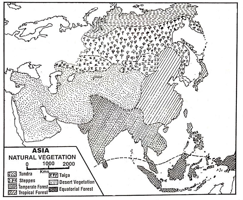
Asia being a large continent great variation in climate causes variations in the distribution and type of natural vegetation. Almost all types of natural vegetation grow in Asia. The natural vegetation of Asia can be classified into the following Natural Vegetation Belts of Asia.
1. Equatorial Evergreen Rain-Forests:
These dense evergreen forests are in the equatorial region due to high temperatures and rainfall. In Asia, these forests are found in Indonesia, Malaysia, Sri Lanka, etc.
Luxuriant forests of multiple species of very tall trees (about 45 meters) struggle towards the sunlight forming a thick canopy arrangement. They yield tropical hardwoods.
The principal trees are Mehogony, Rosewood, Ironwood, Teak, Ablus, Rubber, Cocoa, Cinchona etc. There is a thick undergrowth of numerous epiphytes.
At the ground level saprophytes are found in numerous varieties. This thick growth makes the commercial exploitation of the forests very difficult.
2. Tropical Monsoon Forests:
This is a typical forest, found in regions of monsoon climate. Due to humid summers and dry winters, both green and deciduous trees grow in this region. These forests are found in northern Malaysia, Thailand, Kampuchea, Vietnam, Laus, India, Pakistan, Bangladesh, Myanmar and South China.
In the areas having more than 200 cm rainfall evergreen forests are found, and the lands which get rainfall between 120-200 cm have deciduous monsoon forests. The principal trees are Mango, Mahogany, Ablus, Sal, Teak, Bamboo, Banyan, Peepul etc.
On mountains are found mixed types of deciduous vegetation and on coastal lands mangrove trees.
3. Sub-Tropical Mixed Forests:
These are so-called because of the admixture of deciduous trees with the majority of evergreen trees. One important aspect of these forests is that they marge into grasslands, both tropical and temperate and form parts of the ‘Pask land’ aspect of the grassland borders.
The evergreen trees decrease in number as one advance from coastal lands into interior parts. The deciduous trees occur equatorward and evergreen poleward. These forests are mainly found in northern Myanmar, southern and central China and in southern Japan.
The trees range from bamboo, palm, laurel, and beech as deciduous varieties. Important evergreens include chestnut, oak, camelia, and magnolia.
4. Temperate Mixed Forests:
These forests have two main characteristics. Firstly, the trees, are of mixed variety-deciduous and coniferous. Deciduous trees like oak, ash, alder, chestnut, and beech are a response to a temperate moist climate.
Theconferious trees like spruce, larch, silver fur and red pine are adapted to mountain regions like Hanshu Island of Japan. These mixed forests occur in North China, Manchuria, Central and northern Japan and in the adjoining areas.
5. Mediterranean Forests:
These forests are found along the Mediterranean coastal lands mainly in Israel, Syria, Lebanon and Turkey. Most plants like vines and chestnuts have long roots and others like citrus fruits trees have waxy leaves; others like olive small leave.
A number of citrus fruit-bearing trees such as Olive, Grapes, Lemon, etc. and other trees such as Cork-Oak, and some bushes such as Laurel, Lavender, Rosemary etc. grow here.
6. Steppe Grasslands:
In the mid-latitudes in the interior of the continent extending from the west to Manchuria in the east covering southwest Siberia, fringes of the Mongolian plateau and lowlands of Manchuria are extensive areas of grasslands known as ‘Asian Steppes’.
The steppes of central Asia are very dry and they get scanty rainfall ranging between 30 – 50 cm received mainly in summer. Most people lead a nomadic mode of life.
“importance of Asia in global trade and economy”
They are found in the Kirghiz steppe and Manchurian lowlands. Northward these grasslands form a ‘parkland’ with coniferous forests and southward they border the desert areas.
7. The Cool Temperate Or Evergreen Coniferous Forests Of Taiga :
These forests are found in high latitudes and mountain slopes. Their climate is characterised by cool Temperate Continental (Siberian) Climate and they are located South of the Tundra region. In Asia, these forests cover the areas of northern Russia including Siberia and Sakhalin.
The evergreen coniferous forests are of moderate density with little undergrowth and are in pure stands (a single type of forest). The trees are conical in shape to prevent the accumulation of snow on the branches and have small, thick, leathery needle-shaped leaves to check excessive transpiration.
Pine, fir, spruce, larch, hemlock, and cedar are common trees. The Taiga forest of Russia is the largest coniferous forest in the world.
8. Desert Vegetation :
The hot deserts in South-west Asia are also not without vegetation. There are of course spiky grass, dwarf bushes, and prickly plants. The vegetating corner of the continuous type is mostly found near or around the oasis.
Tall trees like dates and palms may also be found there. The clumps of leafless thorny perennials and others with stunted growth resist evapo transpiration. Cacti and in fact all the thorny bushes are among such plants grown in the desert.
9. Tundra Vegetation:
The Tundra Vegetation belt extends in a narrow belt north of the Arctic circle and along the northern shores of Asia. Winters are long (8-9 months) and very severe. So the Tundra is a result of excessively cold, strong winds and permanently frozen subsoil.
During the summer of 2-3 months willows and dwarf shrubs exist in favoured brutalities. The south-facing slopes exhibit in summer a short-lived splendour of flowering herbaceous plants. Moss, lichen, algae, sedges and bright Arctic flowers brighten the landscape.
Chapter 9 Continent Of Asia Yangtze-Kiang Basin Of China
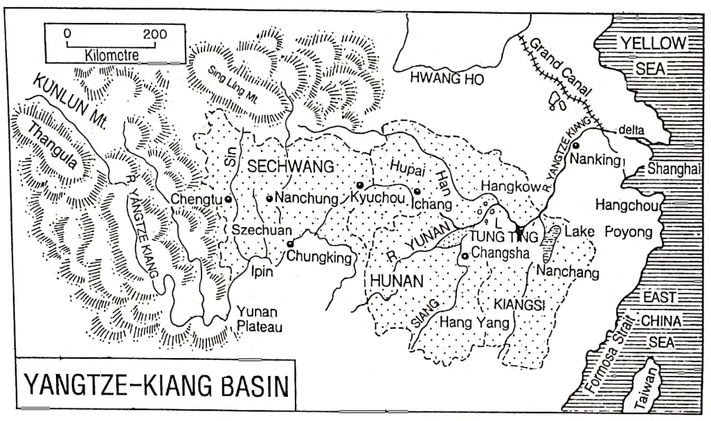
The Yangtze-Kiang basin of China is drained by the river Yangtze-Kiang and its tributaries. Yangtze-Kiang is the third longest river in the world, after the Nile and Amazon rivers. The Yangtze- Kiang is the longest river in China as well as the continent of Asia.
The river originates from a glacier lying southwest of the Geladandong peak of the Tanggula Mountain in Qinghai province and flows eastwards to meet the East China Sea.
From the source to the mouth, the river extends for nearly 6300 km, covering a basin with an area of 1807199 square kilometres. Near the mouth, the river has formed a huge delta.
Importance of Yangtze-kiang Basin:
Yangtze-Kiang is not only the longest river in China but also the most important of all rivers. The river plays an important part in the economy of the country. The river basin is a fertile and multi-cropping zone. A large number of food and cash crops are raised.
The basin is one of the largest producers of rice. In China, 70% of the rice production occurs in this region and nearly 50% of all other food grains are produced here. So this river basin is called the “Granary of China” or the “Rice bowl of China”.
Sericulture is an important occupation of the people of this region. A large proportion of the mineral wealth and industrial products are also produced in this region.
A Geographical Divisions Of Yangtze-Kiang Basin
Due to differences in relief, soil and climate, the Yangtze-Kiang basin is divided into three sub-divisions-
- The upper course or Szechuan Basin or Red Basin,
- The central or Middle course of the Yangtze-Kiang Basin and
- The Deltaic course or Delta region of Yangtze-Kiang Basin.
1. The Upper Course Or Szechuan Basin Or Red Basin:
Szechuan means “four streams”. The Szechuan basin is formed by the deposition of four tributaries (Min, To, Wu and Chialing- Kiang) at the source of the Yangtze-Kiang. Most of the Szechuan province in southwestern China Is included in this region.
Except for the Yangtze gorge, this lowland region is surrounded by highlands or mountains. It has been formed by the infilling of silt in an ancient lake. As the soil is red in colour this region is also called the ‘Red Basin’.
The Red Basin extends from the source of the Yangtze-Kiang to Ichang. In terms of climate, soil, terrain and natural resources, Szechuan has no rival.
It is one of the most populous of China’s provinces because of its comfortable climate, extraction of minerals, and agricultural and industrial development. The two important cities and, industrial centres are Chunking and Chengtu.
2. The Middle Course Or Central Basin Of Yangtze-Kiang:
The Middle Course or Central Basin of Yangtze-Kiang is characterized by extensive fertile plains and many lakes. It is extending from Ichang to Hunan. It includes four provinces of Hupeh, Hunan, Kiangsi and Anhwei.
It is one of the greatest agricultural regions. This region prospers in agriculture due to the presence, of
- Extensive plain,
- Fertile alluvial soil,
- Favourable climate and
- Development of irrigation, use of chemical fertilizer and high-yielding variety of seeds. This region is a multi-cropping zone. Many food and cash crops are raised.
The southern provinces of Hunan and Kiangsi are famous as the huge quantity producer of paddy. Plenty of rice produced in Hunan province is known as the ‘Rice Bowl of China’ or the “Store house of rice”. Wheat, barley, sugar cane, oil seeds, cotton etc. are also produced here in notable quantities.
As the middle course or central Yangtze-Kiang basin prospers in agriculture it is known as the ‘Granéry of China’. Sericulture is an important occupation. The hill slopes have many tea gardens. The region is rich in mineral resources such as coal, iron ore, tungsten, lead, zinc, manganese and antimony.
The largest industrial conurbation in the Middle Yangtze Kiang Basin is formed by the three cities of Wuhan, Hanyang, and Hankow.
3. The Deltaic Course Or Delta Region Of Yangtze-kiang Basin:
This region extends from Nanking in the west to Shanghai in the east near the East China Sea, the mouth of the river Yangtze-kiang. The entire region lies in Kiangshu province. The delta is almost level, only 10% of it is a swamp.
It is a region with numerous canals, distributaries, lakes, dykes and sand bars, as in Holland (Netherlands) there are many Poldarlands, rivers channels, creeks and lakes. So it is called the “Holland of China” as well as the “Holland of Asia”. This delta region is also called “water country”.
Holland is lowland and gets submerged during high tides. To save the country, the people of Holland erected a number of circular dykes and thereby they have saved the country.
Just like the people of Holland, the people of the Yangtze-Kiang delta region of China also have erected a number of dykes in the delta area of the Yangtze-Kiang and thereby they have reclaimed a vast region.
It is developed in agriculture as well as agro-based industries. Because of the similarity this region is known as the “Holland of China”.
The region is developed in agriculture. Crops produced in the region are rice, wheat, cotton, tobacco, oilseeds soybeans etc. Mulberry trees are cultivated for silkworms. Animal husbandry is also developed here.
Though the region is not important in mineral wealth, yet, some coal, petroleum, salt etc. are produced the region is developed in agriculture.
Nearness to raw materials well-developed transport and communication, cheap labour, hydel and thermal power, wide market, port facilities etc. have favoured the growth of industries here.
The entire delta is developed in the cotton textile industry. Shanghai is the main cotton textile industry centre. So it is also called the “Manchester of China”.
Shanghai has always been the leading industrial centre and well as the largest city in China. Shanghai lies on the Whangpu River, 24 km from the Yangtze.
The growth of Shanghai as the premier port and city of China is due to foreign trade. It has now grown into a metropolis of 10 million people.
Except for cotton textiles, Shanghai manufactures a wide range of products including electrical appliances, bicycles, tractors and chemicals. It also has steel, ship-building and oil-refining industries.
Causes Of Economic Development In The Yangtze-Kiang Basin
The Yangtze-Kiang basin of China is economically developed. The causes of the economic development of this region are as follows:
- Extensive Plainland: This extensive plainland helps to expand agriculture, industry and transport.
- Favourable Climate: Pleasant and comfortable climate of this region has favoured agriculture, the industry as well as human settlement.
- Fertile Alluvium/ Loamy Soil: Fertile alluvium/ loamy soils have favoured agriculture very much.
- Plenty Of Water Resources: Plenty of water resources have favoured irrigation facilities, industrial needs, hydroelectric, drinking water supply and as well as fertile silt deposition.
- Plenty Of Mineral Resources: Plenty of mineral resources such as coal, iron ore, copper, zinc, tungsten, antimony etc. have favoured industrialization.
- Good Transport System: Good transport facilities-railways, roadways, waterways etc. help the region to e economically developed.
- Location Of Ports: Port facilities of Shanghai, Nanking, and Chunking Ports are important for the economic development of the Yangtze-Kiang basin.
- Good Infra-Structure: Good infrastructure is also helpful for the development of this region.
- Development Of Industries: Development of industries such as iron and steel, chemical, silk and cotton textile and tools and machinery also help to the economic development of this region.
- Thick Population: Thick population of this region is help to supply the available skilled or unskilled labours for agricultural as well as industrial requirements.
Causes Of Dense Population In The Yangtze-Kiang Basin
The Yangtze-Kiang basin occupies nearly one-fifth of the total area of China. But at the same time, nearly one-fourth of the total population of China lives in this basin. Thus very dense population occurs in this region. The causes of this dense population are as follows:
1. Easy Earning Of Living:
Yantgtze-Kiang Delta region is densely populated because earning of living is easy here.
2. Rich In Agriculture:
The Yangtze-Kiang Basin is the richest agricultural area in China. The region is very fertile as the region is made of fertile silt deposited by the river Yangtze- Kiang. Irrigation facilities have favoured agriculture very much. Rice, wheat, tea, sugarcane, oilseeds etc are produced here.
About 70% of China’s rice is produced from this region, and 50% of other crops too. It results in more earnings from agriculture than any other region of China.
3. Rich In Mineral Resources:
The basin is also the leading mineral-producing region of China. A large amount of iron ore, petroleum, natural gas, antimony, natural gas, tungsten etc. is produced in the region which causes this region to be economically rich resulting in a dense population.
4. Industrially Developed:
The Yangtze-Kiang basin is the most industrialised region of China. Large industrial centres like Shanghai, Wuhan, Nanking, Chunking etc. are located in this basin. Therefore, the development of industries in this region has caused a great density of population.
5. Transport And Communication:
The transport and communication system of this region is well developed, because of roadways and railways facilities.
6. Others:
Amusement, education, games and other facilities are available in this basin has caused it to be the most densely populated region in China.
Chapter 9 Continent Of Asia Tokyo-Yokohama Industrial Region Of Japan
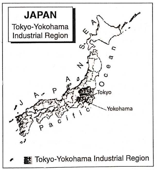
At present Japan is the greatest industrialised country in Asia. In the world, it ranks third only following the U.S.A. (1st) and Germany (2nd). The most important industrial region of Japan- the Kihin or Tokyo-Yokohama industrial region has developed in the Kanto plain.
Kanto – (Kwanto) plain is situated in the eastern part of Hanshu Island. Among the four main islands of Japan Hanshu is the largest one. Kanto plain is divided into seven regional divisions, which are
- Ganma,
- Tochigi,
- Ibaroki,
- Tsaitama,
- Tokyo,
- Chiba and
- Kanagawa.
The density of the population of the Kanto plain region is very high. About one-third of the total population of Japan lives here. This plain extends around the gulf of Tokyo.
A number of large cities have developed along the coast of the gulf of Tokyo. Within this region, there are forty large towns including Tokyo, Yokohama, Kawasaki and Chiba.
Importance Of Tokyo-Yokohama Industrial Centres
Tokyo:
Tokyo, the capital of Japan is situated on the southeast coast of Hanshu at the head of the gulf of Tokyo. Tokyo is the largest city, important port and the largest industrial and trade centre in Japan.
It is now one of the largest cities in the world and a great centre of Japan’s political, economic and cultural life.
Over 20 million people live within a circle about 50 km from its centre. The city includes vast non-urban areas at the periphery for future growth. So Tokyo is an overbounded city. In contrast, Kolkata is an unbounded city.
Tokyo’s industrial complexes include textiles, cars, food processing, plastics, breweries, optical instruments and publishing. Tokyo is also the largest centre of printing.
Yokohama:
Yokohama is the second-largest city and the largest port in Japan. It is located about 30 km. away from Tokyo in the south of Hanshu island.
The large ships cannot enter the port of Tokyo as the gulf is shallow there. So, Yokohama plays the role of the largest external port in Japan.
Yokohama has steel, motor vehicles, chemicals, shipbuilding, oil refining and also fish canning and silk and rayon manufacturers. Its satellite town Kawasaki has ship-building, steel and textiles. Chiba is noted for its iron and steel industry.
| Industrial Region | Important Industrial Centres | Major Industries |
| Tokyo-Yokohama or Kihin Industrial Region (Kwanto Plain) | Tokyo | Cotton textiles, optical instruments, automobiles, electronic equipment, paper, printing and publishing. |
| Yokohama | Steel, motor vehicles, chemicals, shipbuilding, silk and rayon textiles. | |
| Kawasaki | Shipbuilding, steel and textiles. | |
| Chiba | Iron and steel, chemical, shipbuilding. |
Causes Of The Growth Of The Tokyo-Yokohama Industrial Belt
The factors favourable to the growth of the Tokyo-Yokohama Industrial Belt as one of the best and most significant industrial Belt in the world are as follows:
1. Agricultural Development:
The Tokyo-Yokohama region is rich in agriculture. The volcanic fertile soil, suitable climate etc. are ideal for the production of rice and other agricultural crops which are also supplied as raw materials in a number of industries.
2. Favourable Climate:
The insular climate of this region is encouraging and suitable for hard work.
3. Density Of Population:
Being densely populated, the region is supplying a cheap and skilled labour force for industrial development.
“practice exercises on continent of Asia WBBSE geography”
4. The Spirit Of The Japanese People:
The spirit of the Japanese people, ‘Nippon Seichin’ has contributed largely to making Japan the industrial leader of the Orient. The Japanese are ready to work harder than almost any person on earth for the sake of their country
5. Power Resources:
Required power is obtained from a large number of hydroelectric power stations of central Hanshu and Tukai nuclear power stations.
6. Water Resources:
The short and swift-flowing rivers of Japan are helping a lot in the industrial development of this region by providing cheap hydel power and required industrial water.
7. Developed Transport And Communication System:
The region is crisscrossed by a large number of roadways and railways and there helped quick and rapid transport. The numerous natural and man-made water courses on the lowland provide excellent transport facilities.
8. Port Service:
Tokyo-Yokohama ports provide port facilities. Raw materials are imported and final goods are exported through these ports.
9. Uses Of High-Technology:
Uses of high-fi technology favoured this industrial belt to be developed in the field of industries, trade and commerce.
10. Market:
Because of the dense population, the local market and also the international market are wide.
11. Government Policy:
The policy of the Japanese Government is to ensure Japan’s survival in the face of full competition among the western industrial powers.
Industries Of Tokyo-Yokohama Industrial Region
Important industries of Tokyo-Yokohama Industrial Región are as follows:
- Iron and steel,
- Automobile,
- Ship-building,
- Cotton textiles,
- Woollen textile,
- Electronics,
- Paper,
- Food-processing,
- Biotechnology,
- Manufacturing of aircraft and machine tools,
- Optical instruments, especially cameras and binoculars,
- Petrochemicals,
- Oil refining,
- Printing and publishing,
- Information and technology.
Problems Of The Tokyo-Yokohama Industrial Region
Though Tokyo-Yokohama industrial region is the largest industrial belt of Japan, yet at present, this region faces some problems. These are as follows:
- Excessive concentration of industrial complexes.
- Rapid urbanization.
- Decentralisation of different industries.
- Scarcity of land
- The excessive increase in land value,
- Limited transportation.
- Lack of cheap labour.
- Overpopulation.
- Environmental pollution.
- International competition.
How Can The Problems Be Solved:
The following remedies should be taken to solve the above problems of the Tokyo-Yokohama industrial region.
- To control and prevent industrial pollution.
- Proper treatment and reuse of wastes are to be achieved.
- To shift the factories to other places. (The Japan Government is considering the shift of the factories to Chiba, Ibaraki cities in particular).
- Importance should be given to the reclamation and re-orientation of land use.
Special Features Of The Yokohama Industrial Region
There are some special features of Yokohama Industrial centres in respect of other industrial regions in the world. These are as follows:
- Yokohama industrial centre has successfully controlled and prevented industrial pollution.
- This city has been declared an ‘eco-friendly city’ by the Government of Japan in 2008.
- Importance is given to the reclamation of fallow land to re-orientation of land use.
- Importance is given to agriculture to be as important as industries.
- This city has been a worldwide trendsetter regarding urban planning.
- To restrict the wastage of resources proper treatment and reuse of waste have
Chapter 9 Continent Of Asia Oil Field Of South-West Asia
Petroleum or mineral oil is an inflammable mixture of oily hydrocarbons with very complex chemical properties. It is an important fossil fuel. Modern mechanised civilization is fueled by petroleum.
Petroleum is an important source of power, and lubrication of machines in factories and its most significant use of it is transportation.
Besides, petroleum is used to produce many substances, such as plastic, artificial rubber, artificial fibre etc. It has a wide range of uses and nowadays, it is an invaluable resource.
For its endless usefulness, petroleum is called ‘liquid gold’. Though it is such a precious resource, it is only produced in a few countries of the world.
South-West Asian countries play a very important role in world petroleum production and export. South-West Asia forms a land bridge between Europe, Asia and Africa.
The countries of South-West Asia are known as the ‘Countries of five seas’ which surround South-West Asia.
In the north of South-West Asia lies the Black Sea, in the North-West Mediterranean Sea, in the west the Red Sea, in the south Arabian Sea and in the south-east the Persian gulf.
The countries of South-West Asia are connected with other countries by water routes through one or several of the seas mentioned above and hence called “Countries of five seas”.
The countries of South-West Asia occupy the highest position in the world in respect of petroleum extraction. About 60% of the world’s total mineral oil resources are found in this region.
“impact of geography on Asia’s population distribution”
This region mines about 30% of the total petroleum in the world. The climate in these South-West Asian countries is very hot and dry.
The population of South- West Asia is low and the demand for petroleum is not so high. So, the best part of the oil mined is exported here and the economy of these oil-producing countries is export-oriented.
As they produce and export precious petroleum, gradually oil field-based cities have grown and they live a luxurious life.
The principal producing and exporting centres of South-west Asia are-
- Saudi Arabia,
- Iraq,
- Iran,
- Kuwait, The Persian gulf state of
- Bahrain,
- Qatar,
- United Arab Emirates (UAE)
- Oman and
- Syria.
1. Saudi Arabia:
Saudi Arabia is the largest country in the Arabian peninsula, which is the largest peninsula in the world. At present, it ranks first in the world in petroleum production and export.
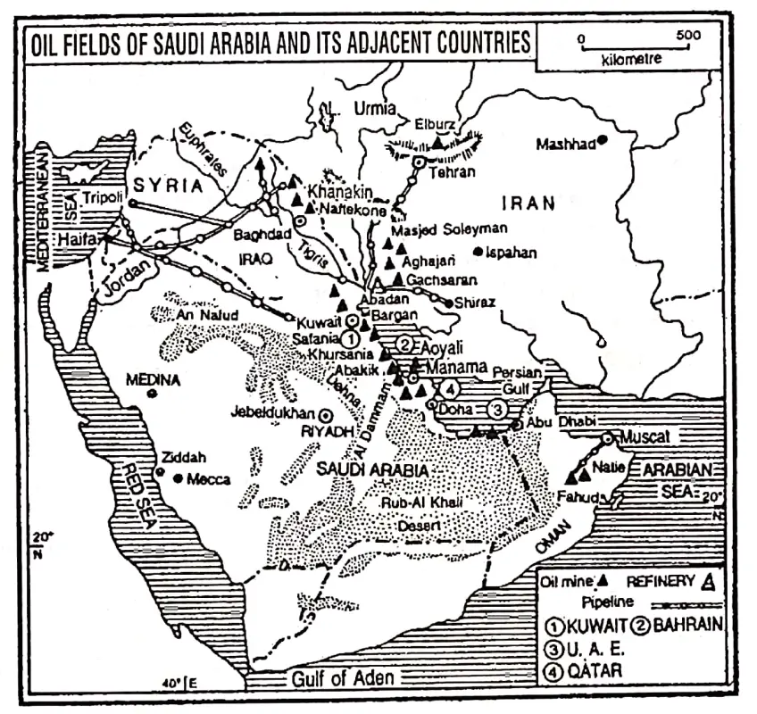
About 26% of the total petroleum reserves of the world are found in Saudi Arabia. The oil fields are located along the coast of the Persian Gulf. The on-shore (inland) fields are at Abqaik, Ghawar, Khuryas, Khursania and Al Qatif.
The off-shore fields are Abu Safa, Manifa, Marjan and Safaniya. The largest on-shore oil field in Saudi Arabia, as well as Asia and the World, is Ghawar and the largest off-shore oil field is Safaniya. Dhahran and Rus Tanura (the largest oil refinery in Saudi Arabia) are noted for oil refineries.
2. Iraq :
Iraq lies mainly in the lower basin of the Tigris-Euphrates river. Petroleum is easily the most important commodity of Iraq.
Iraq is the fourth largest oil producer in the Middle East. The Kirkuk is the largest oil-producing region. Other oil fields of significance are Mosul, Basra, Warfa- Bargon, Zubain, Rumalia etc.
3. Iran :
Iran lies east of Saudi Arabia and on the other side Gulf of Persia. Petroleum is the most important resource of Iran. In mineral oil production Iran occupies the fourth position in the world and holds the second position among the countries of the Middle East.
The major oil fields are located on the coastal strip of the Persian Gulf and on the foothills of Zagros Mountain. Much oil, nearly half of the total production comes from Aghajari.
Other important oil fields found in this area are-Gachsaran, Lali, Masjid-i-Suleiman, Halftkel, Marun, Naft-i-Shah, Awaj etc. Abadan is one of the greatest oil-refining centres in the world. One-third of the crude oil is refined in Iran.
4. Kuwait :
Kuwait, a small country, on the northeast of the Persian Gulf, is noted for petroleum. The per capita income of the local people is the highest in the world because the per capita production of petroleum is the highest.
Burgan and near it Magwa-Ahmadi produce the maximum oil. More than 80% of the production is piped to Mina-al-Ahmadi port for export.
5. United Arab Emirates (UAE):
U. A. E. is located to the east of Saudi Arabia, adjacent to the Persian Gulf. It is formed of seven Arab Emirates:
- Abu Dhabi,
- Dubai,
- Sharjah,
- Ajwan,
- Um-El-Koyayan,
- Ras-El-Khaima and
- Fujairah. Most of the U.A.E. is desert but enormous quantities of petroleum are extracted. Abu Dhabi and Dubai are famous for petroleum production.
6. Bahrain :
In the Middle East Belt, Petroleum was first struck in Bahrain in 1932. Jabal Al-Dukhan is the major oilfield. The oil fields of Awali is also significant.
7. Qatar:
Qatar is a small country located in the east of Saudi Arabia on the coastal margin of the Persian Gulf. Jebel-Dukhan and Id-Al-Sharkhi are important for oil mines.
“environmental issues and conservation efforts in Asia”
8. Oman:
Oman, situated on the southeast of the Arabian peninsula, is also noted for petroleum: Fahud and Natih are the major oilfields of the country.
9. Syria:
Syria is nearly self-sufficient in petroleum production and is exporting a little.
| Petroleum Producing and Exporting Countries Of South-West Asia | Capital Of the Countries | Important Oil-Fields |
| 1. Saudi Arabia | Riyadh | Ghawar, Abqaik, Dhahran, Khuryas, Khursania, Safaniya Manifa. |
| 2. Iraq | Baghdad | Kirkuk, Mosul, Basra, Warfa-Bargon, Zubafn, Rumalia etc. |
| 3. Iran | Tehran | Masjid-i-Suleiman, Naft-i-shah, Lali, Aghajari, Halftkel, Gach saran. etc. |
| 4. Kuwait | Al-Kuwait/ Kuwait City | Burga/i, Magwa-Ahmadi, Aaljara. |
| 5. United Arab Emirates | Abu Dhabi | Dubai, Abu Dhabi, Murban, Amirshahi. |
| 6. Bahrain | Manama | Jabal-al-Dukhan, Awali. |
| 7. Qatar | Doha | Jebel Dukhan, Id-el-ljba, Id-al-Sharkhi. |
| 8. Oman | Muscat | Fahud and Natih |
| 9. Syria | Damascus | Al-ljba, Omar. |
OPEC:
Most of South-West Asia and a few other petroleum-producing and exporting countries have formed an organization in 1960 to protect their oil resources, and improve their interest and their benefits. T
The organization of the most oil-producing centres of the world is called OPEC or the Organization of Petroleum Exporting Countries. In Asia, these countries include Saudi Arabia, Iraq, Iran, Kuwait, U. A. E, Qatar and Indonesia.
In Africa, they include Gabon, Nigeria, Libya and Algeria. In South America, they include Ecuador and Venezuela. The main objectives of the OPEC are
- The determination of oil policy,
- The determination of oil price in the international market,
- The control of oil production to maintain the price level of petroleum and
- To preserve the interest of the members in exporting oil.
The OPEC countries export nearly 80% of the petroleum produced in the world and they have nearly two-thirds of the petroleum reserves of the world.
