
Chapter 11 Continent Of Europe
Introduction:
The continent of Europe is a cluster of peninsulas and islands that extends North-West of Asia. Amongst the seven continents of the world, Europe ranks sixth in area.
It occupies about 7% of the land surface of the earth but it has about 15% of the world’s total population. It is important because it is centrally placed in the Northern hemisphere, midway between the Old and the New World.
It has helped in the growth of trade between a number of countries. It is a sub-continent of plains and mountains and a variety of resources. So, Europe’ is the most favorable continent for mankind.
Europe has been called the “most active of the continents” on account of the large volume of its trade and industry and its density of population.
Read and Learn More WBBSE Notes for Class 7 Middle Class Geography
Location:
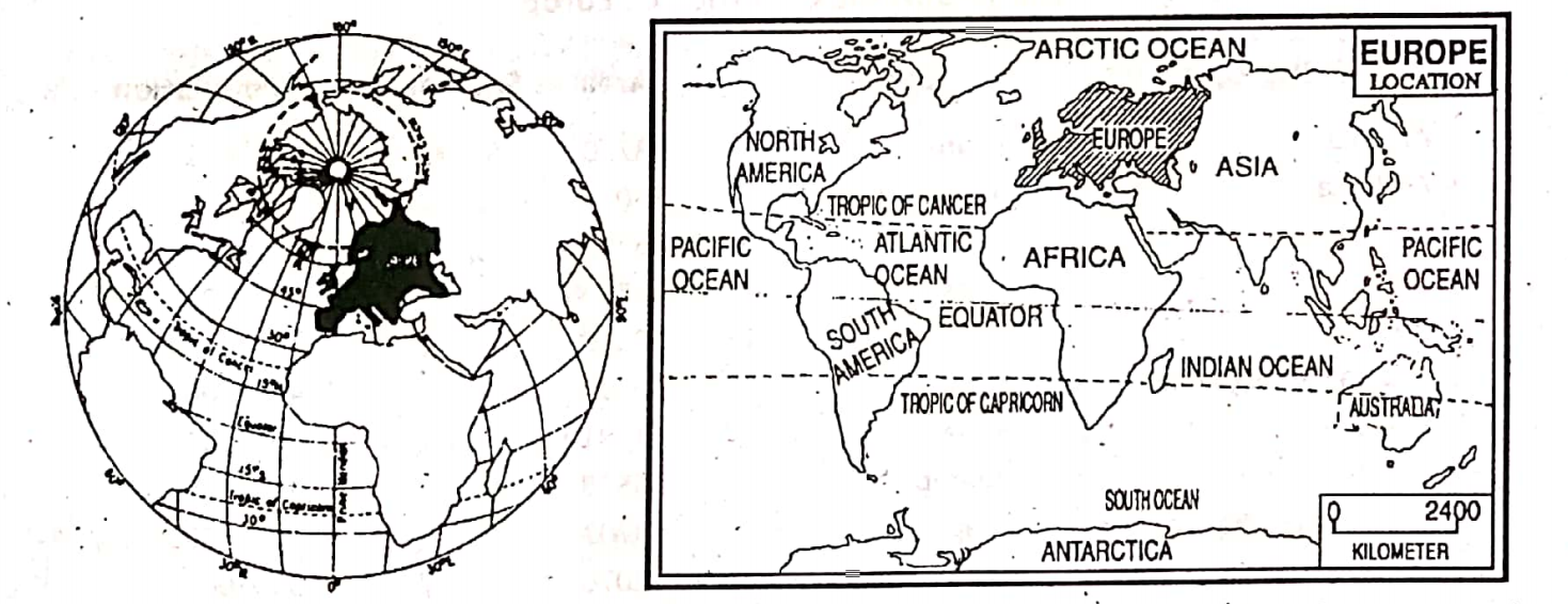
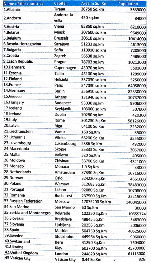
The continent of Europe (mainland) extends approximately from 35°N latitude (Cape Tarifa of Spain) in the south to 71°N latitude (North Cape of Norway) in the north and from 9°30′ West longitude (Cape Roca) in the west to 65° east longitude (the Ural mountain) in the east.
Thus, Europe covers about 75° longitudes in the east-west and about 35° latitudes in north-south extensions. The island of Iceland, however near the Arctic Circle, is found at 20°W longitude.
Boundary:
Europe is bounded by the Arctic Ocean, White Sea, and Baltic Sea on the north, the Atlantic Ocean on the west, and the Mediterranean Sea and the Black Sea on the south. On the east, there is a landmass, that the term ‘Eurasia’ is often applied where the continent of Europe merges into Asia and it has no well-defined boundary.
In the absence of better boundaries, the Ural mountains, the Ural River, the Caspian Sea, and the Caucasus mountains may be taken as the eastern limit of Europe. On its three sides-north, south, and west, Europe is bordered by water bodies. In fact, this continent forms a great western peninsula of Asia.
Area and Extension:
Europe is the sixth largest continent in the world. It covers an area of about 10,400,000 square kilometers. It is three and a half times the size of India. The mainland of Europe is about 5760 km from east to west and 3840 km from north to south.
Population:
Though small in size, Europe is the third largest populated continent in the world. Its population is more than 750 million which contributes about 15 per cent to the world’s total population.
Chapter 11 Continent Of Europe The Countries Of Europe
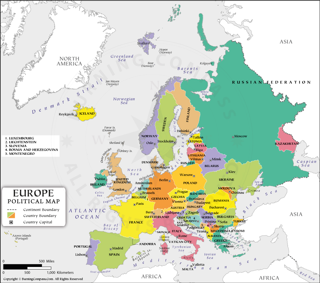
Europe is a very small continent, but it consists of about 54 countries. Most of the countries are small in size but very important. In the north are countries like Iceland, Norway, Sweden, and Denmark which are known as ‘Scandinavian countries’.
The Soviet Union (U.S.S.R.) was the largest country in Europe (before 1991). Now it has been divided into 15 independent republics.
Of these, nine republics and a large part of Russia are a part and parcel of Europe, and three of these 15 republics of former U.S.S.R., normally Estonia, Latvia, and Lithuania are. known as Baltic states.
Serbia and Montenegro, Bulgaria, Greece, Romania, Bosnia-Herzegovina, Macedonia, and Albania are known as Balkan states. Greece and Italy are famous for their ancient civilizations.
A small and independent city-state called the Vatican is the seat of the Pope and the headquarters of the Roman Catholic Church. San Marino is the smallest democratic republic state in the world.
The Important Countries Of Europe
Chapter 11 Continent Of Europe Geographical Importance
Europe is the sixth largest or second smallest (after Oceania) continent in the world. It consists of about 54 countries. Most of the countries are small but very important.
Considering its development in science and technology, agriculture and industry, education and culture, trade and commerce, there is no doubt about Europe’s foremost position amongst the continents of the world. Several geographical factors have contributed to this. These favorable factors are as follows:
1. Central position of Europe in the Northern Hemisphere:
Of all the continents Europe is the most centrally located. So, it has easy access to the shores of Africa, Asia, America, and even further Oceania by sea.
2. Nearness to the Seas or Maritime location of Europe:
The continent of Europe enjoys the influence of inland seas, deep bays, and gulfs; so no part of it, except Russia is more than 650 km, from the sea. The seas, bays and gulfs have not only provided ideal sites for fishing but have made the people of Europe sea-minded.
They encouraged the discovery of unknown lands and trade routes. They have affected the life of the people of the world with their ideals, movements, and inventions. As such for centuries Europe occupied a unique position in the world.
3. Broken Coastline Of Europe:
Considering its size, the continent of Europe has the longest coastline of 38,400 km as compared to all the other continents. The coastlines of Europe are irregular and broken in most places which favors the development of a maximum number of modern ports in the world.
World-famous ports like London, Rotterdam, Genoa, and Marseilles are important.
4. Temperate Climate of Europe:
Europe is the only great landmass that lies almost entirely within the temperate zone. So, here the cool temperate climate enables people to work for long hours.
5. Extensive fertile plains:
Europe has extensive fertile plains and it has the greatest proportion of agricultural land and habitable land than any other continent. There are no large deserts in the whole continent, except for the cold desert of Tundra in its northernmost part.
6. Water Resource:
Numerous navigable rivers are flowing in different parts of Europe. These rivers supply drinking water, irrigation water, and industrial water also.
7. Forest Resource:
Europe is endowed with coniferous forests. Extensive coniferous forests of pine, fir, and birch trees have helped in the tremendous growth of paper and ship-building industries in Europe.
8. Mineral Resource:
Europe is enriched in different types of minerals. The important minerals are petroleum, coal and iron ore.
9. Agricultural Resource:
Europe is highly developed in agriculture. Agriculture in Europe is highly mechanized. Important cereals are wheat, barley, maize, oat, and sugar beet, vegetables and flowers are also grown here. Ukraine is popularly called the “Granary of Europe”.
10. Animal Resource:
Europe is famous for animal products. Russia, Ukraine, Denmark, Netherlands, Germany, the U.K., and France practice cattle and sheep rearing on rich pastures by applying modern techniques. So, milk and milk products, meat, and wool are produced on a commercial basis in Europe.
11. Developed Fishing grounds:
The continental shelf of northwest Europe is famous for fishing grounds. So, countries like Iceland, Norway, U: K., Denmark, Germany, and France are famous for commercial fishing.
The world’s most skilled fishermen are found in Iceland and Norway is called the “Land of Fishermen”.
12. Industrial Development:
Europe is the home of the ‘Industrial Revolution’ and presently the most industrialized part of the world. Most of the important industrial regions of the world namely, Ruhr industrial region, Moscow industrial region, London Basin, Paris Basin, and Donets industrial region are located in Europe.
13. Preservance and Resourcefulness of the people:
The people living on this continent are energetic, enterprising, and progressive. Europe’s economy, ruined twice by world wars recovered mainly due to the sheer presence and resourcefulness of its people.
So, the favorable physical environment and the most dynamic working ability of the Europeans have made this continent geographically very much important in the whole world.
Chapter 11 Continent Of Europe Physical Features Of Europe
Relief:
Europe is a very small continent but physiographically it is very much diversified. Though the greater part of the continent is plain land, it also has high plateaus, mountains and very low-lying areas.
Generally, the continent can be divided into the following four distinct physiographic divisions, namely-
- The North-western Highlands;
- The Great North-Central European Plains;
- The Central Plateaus and Uplands; and
- The Alpine Mountain system or Southern Mountains of Europe.
The North-Western Highlands
The north-western part of Europe is a region of highlands. Mountainous lands of Scandinavia (Norway and Sweden). Finland, the highlands of the north-central U.K., and the northern mountains of Ireland are included in this region.
Physiographic characteristics of this region are as follows:
- These mountains are the oldest in Europe. For a long time, they remained under the erosive influence of running water and the glaciers.
- Most of these mountains and plateaus are low and have very gentle slopes.
- These mountain ranges penetrate deep into the sea.
- At certain places (as in Norway) long, narrow, and deep arms of the sea, penetrate into the land between high cliffs. They are known as ‘fiords’. Fiords are in fact deep valley cuts by glaciers and are now filled with water. They make the coastline highly indented and rugged.
- The mountain ranges of this region have eroded for a long period and reduced to a plateau land.
- Geologically it is composed of ancient metamorphic rock. The area near the Baltic Sea is known as the ‘Baltic Shield’.
- There are different mountain ranges. Caledonian mountain ranges have originated 40 to 50 crore years ago. These are-
- Doverfield of south-west Norway,
- Kiolen mountains along the Norway-Sweden border,
- Grampian Mountains in northern U.K. and Cheviot hills of Central U.K. ‘Glittertind’ (2470 m) located to the south of Doverfield is the highest peak of Scandinavia. ‘Ben Nevis’ (1344 m) of Grampian mountain is the highest peak in the United Kingdom.
- Lakes are common everywhere and are, actually, traces of ancient ice sheets. There are more than 40000 lakes in Finland which are, therefore, called the ‘Land of thousand lakes’ or the “Country of ten thousand lakes’.
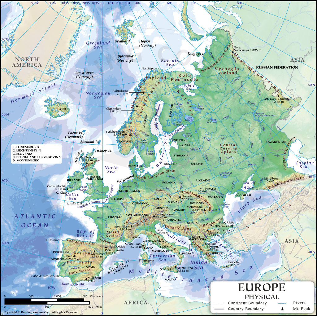
The Great North-Central European Plains
These plains extend from the Ural mountains in the east to the Bay of Biscay in the west and are located to the south of the north-western highlands. Southern parts of the U.K., Northern France, Netherlands, Belgium, Poland, Northern Germany, and Western Russia are included in this region.
Physiographic characteristics of this region are as follows:
- These plains are not flat like the Indo-Gangetic plain. In certain places, they are gently rolling areas and in others, they are broken by mountain chains and hills.
- The average height of the plain is 180 m. But it is a little higher in the east. A few small hills are also found, such as Voldai Hills (305 m).
- Most of the long rivers of Europe are flowing through this region. These are Volga, Rhine, Don, and Dnieper.
- Many large lakes in Europe were formed by glacial erosion, such as Ladoga (18130 sq. km) and Onega (9842 Sq. Km) in Russia. Ladoga is the largest lake in Europe.
- An extensive area has been reclaimed from the sea in the Netherlands and is known as ‘Polder land’.
- These plains also contain regions of old rocks that are rich in metallic minerals.
- High-grade fossil fuels, like coal, petroleum, and natural gas have been abundantly found in many areas.
- The greater parts of these plains have excellent soil for agriculture.
The Central Plateaus And Uplands
To the south of the Great Plains of Europe, lies the Central Plateau Region and Uplands of Europe. It comprises the Meseta of Spain, the Central Plateau of France, the Rhine highlands, the Bohemian plateau along the Germany-Czech Republic .boundary, and the islands of Sardinia and Corsica.
The physiographic characteristics of this region are as follows.
- These are all much lower than the Alpine mountains and are composed of older rock.
- They are considered to be the broken blocks of an old mountain system.
- Once they were high but now not so high. Their height is not more than 600 meters above sea level.
- They extend from west to east from Ireland to Russia.
- About 32 to 22 crore years ago fold mountains of the Herceynian system were formed. Subsequently, they have been reduced to these low plateaus.
- Many rivers flowing through this region have dissected the plateau into smaller units, such as-
- Meseta of Spain,
- Brittany of France,
- Ardennes of Belgium and
- Don Massif of Russia.
- Due to faulting block mountains namely the Vosges in France and the Black Forest in Germany have formed.
- In between the block mountains of Vosges and the Black Forest is located the rift valley of the Rhine.
The Alpine Mountain System Or Southern Mountains Of Europe
To the south of the central Plateaus and Uplands, there are several ranges of young fold mountains running parallel to one another from the Atlantic Ocean in the west to the Caspian Sea in the east. It covers most parts of southern Europe in Spain, France, Germany, Switzerland, Italy, Greece, Bulgaria, and Romania.
Physiographic characteristics of this region are as follows:
- These mountains have high (lofty) peaks, steep slopes, and deep valleys.
- Among these mountains, the Alpine system or Alps are the most important. They run in great curves from east to west across Southern Europe.
- About 6 to 7 crore years ago, the young fold mountain, the Alps originated in the Tertiary period.
- There are many lofty peaks are found in the Alps. Mt. Blanc (4807 meters) is the highest peak of the Alps. The other important peaks are Mt. Rosa (4634 meters) and Matterhorn (4478 meters).
- There are several other important mountain ranges that run in different directions.
- The Pyrenese is extended along the border of Spain and France.
- Appenine range extends to the whole length of Italy and crosses over to Africa.
- The Dinaric Alps run along the Adriatic sea in Serbia and Albania. Dinaric Alps is further extended southward as Pindus in Greece and Rodhop in Bulgaria and Turkey.
- The Carpathian Mountains make a semi-circle and enclose the Plain of Hungary and run east to west in Bulgaria
- The Caucasus Mountains lie between the Black Sea and the Caspian Sea. The Caucasus is the highest mountain in Europe. The highest peak of the Caucasus, Mt. Elbrus (5642 meters) is the highest peak in Europe.
- These young mountains receive heavy rainfall and are covered with snow and glaciers.
- They contain many lakes and give birth to important rivers in Europe.
- There are some important passes on the Alps, such as
- Brenner,
- Simplon,
- Seniors,
- St. Bernard and
- St. Gotthard.
The fertile plains enclosed by these mountains are. the plain of Lombardy or the Po Valley and the Hungarian and Wallachian Plains of the Danube. The southern fringe of Europe is a region of broken mountain chains, peninsulas, and islands.
Volcanoes:
The recent uplift of the Alps has made this Mediterranean belt unstable. So, this belt is prone to earthquakes and volcanicity. Many volcanoes exist in the northwestern and in southern parts of Europe. These are-Crafla and Hekla in north-western Europe.
Etna(3323 m) on Sicily Island, Vesuvius (1227 m) in Italy, and Stromboli on Lipari Island are located in southern Europe. “Stromboli” is called the ‘Lighthouse of the Mediterranean’ which erupts nearly every hour.
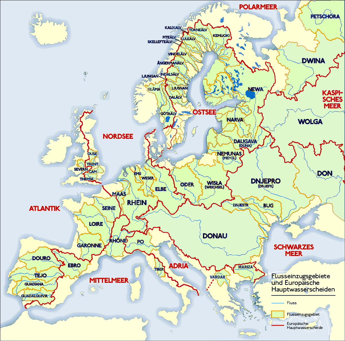
Chapter 11 Continent Of Europe The Drainage System Or Rivers Of Europe
The continent of Europe has many rivers. These rivers are important resources in Europe. The specific characteristic features of these rivers are as follows:
- The rivers of Europe are not very long in comparison to the rivers of Asia, the Americas, and Africa.
- The Alps in the south and Voldai in the east of the continent are two main water divides from which many rivers have originated.
- One important characteristic feature of the Europeans was. rivers are the intricate network of canals that link them.
- The swift-flowing rivers of Europe. are suitable for the generation of hydroelectric power.
- There are many navigable rivers in Europe. They serve as important transport routes for the industrial countries through which they flow
- At the heads of their estuaries and long their banks stand some of the world’s chief cities.
- There are some fertile riverine plains in Europe which are developed in agriculture, e.g. Lombardly or Po valley in Italy.”
- The rivers are of great economic importance as they serve the most important industrial regions of Europe as well as the world.
Important Rivers Of Europe
According to their direction of flow, the rivers of Europe may be grouped into the following categories.
- North flowing rivers,
- South-flowing rivers,
- East-flowing rivers and
- West flowing rivers.
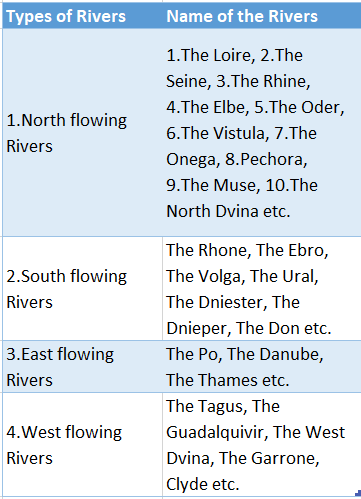
The North Flowing Rivers Of Europe
1.The Loire (1020 Km):
The Loire is the longest river in France. It rises in the “Central Massif” of France, passes through a rift valley, and flows to the northwest before it meets the Bay of Biscay. Orleans and Nantes are important towns on the Loire.
2. The Rhine (1320 Km):
The river Rhine rises in the Swiss Alps and flows through Switzerland, France, Germany, Netherlands, and finally drains into the North Sea at Rotterdam in the Netherlands. As a commercial artery, the Rhine is unrivaled among the rivers of the world. The Neckar, Main, and Moselle are the chief tributaries of the river.
3.The Seine (780 Km):
River Seine rises in the Cote D’or hills located in the northeast of France, flows through Paris Basin, and drained into the English Channel. It is the most important river in France. As the Seine enters Paris, it receives its great tributary, the Marne and after crossing the capital city, it receives the Oise. Le Havre on the estuary is the greatest port in France.
4.The Elbe (1165 Km):
The Elbe is a river in Central Europe. It rises in the Alps of the Czech-Polish border and flows across the Czech Republic and Germany to the North Sea. The river is connected by canals with the Baltic Sea, the Ruhr region, and the Rhine.
5.The Vistula (1047 Km):
The Vistula is the longest river in Poland and it is also the largest of the rivers meeting the Baltic Sea. It rises from the Alps flows eastward and then northward through Poland and empties into the Baltic Sea after forming a delta. Warsaw, the capital of Poland, lies on the Vistula.
6. The Oder (930 Km):
The Oder is a major river in northern Europe. It rises in the Oder mountains of the Czech Republic, flows through Poland and Germany and empties into the Baltic Sea.
7. The Onega (400 Km):
It rises from the Voldai, flows northward and is drained into the North Sea.
8.The Pechora (1940 Km) :
River Pechora rises in the middle of Ural mountain flows northward and drains into the North Sea (Arctic Ocean).
9. The Muse (925 Km):
River Muse originating from Vosges mountain flows through France, Belgium, and Netherlands and is drained into the North Sea.
10. The North Dvina (750 Km):
This Russian river rises in the Voldai; adjacent to the Ural mountain, flows across the Russian Platform and enters into the White Sea.
The South-Flowing Rivers Of Europe
1.The Volga (3690 Km):
The longest river in Europe is the Volga and it is the main waterway of Western Russia. The river rises in the Voldai hills, northwest of Moscow, and flows south-eastwards, through Russia to empty into the Caspian Sea near Astrakhan. Rivers Oka and Kama are two important tributaries of the river Volga.
2. The Ural (2438 Km):
The third longest river in Europe is the Ural. It rises in the south-eastern Ural mountains. It flows south and then southeast and empties into the Caspian Sea. The river marks the boundary of Europe and Asia, south of the Ural mountains.
It is navigable for 1460 Km but freezes in winter. It is connected with the Volga by a canal.
3.The Rhone (813 Km) :
Emerging from the Rhone glacier in the Swiss Alps, the river flows over Switzerland and France to meet the Mediterranean Sea.
4. The Ebro (800 Km):
The Ebro is the longest river in Spain. It rises in the Cantabrian mountains and empties into the Mediterranean Sea.
5.The Dnieper (2285 Km):
The Dnieper is the fourth largest river in Europe. It rises in the Voldai hills, flows southward through Belarus and Ukraine, and meets the Black Sea. About 1669 Km stretch of the river is navigable for ten months. Important cities on the river include Kyiv and Dniepropetrovsk.
6.The Dniester (1352 Km):
The Dniester is a river of Moldavia and southwestern Ukraine. It rises in the Carpathians and flowing south and east, meets the Black Sea near. Odessa.
7. The Don (1920 Km):
It rises in the Central Russian highlands near Tula. It flows to the south and enters the Sea of Azov. The Donetz is an important right-bank tributary of the river. Rostov is the largest river port on the Don.
The East-Flowing Rivers Of Europe
1. The Danube (2857 Km):
The Danube is the second-longest river in Europe. It rises in the Black Forest mountain of Germany and flows through nine countries of south-eastern Europe, such as Germany, Austria, Hungary, Romania, etc. finally it splits into three channels and meets the Black Sea forming a delta.
In the Hungarian Plain, the Danube receives three large tributaries-the Drava, Sava, and Tisza. On its banks lie four capital cities-Viena, Bratislava, Budapest, and Belgrade. There is no river in the world that flows along nine countries, as well as four capitals of them, are situated on the banks of the river.
So, it is called the ‘best international river of the world’ or ‘The most significant international river’.
2. The Po (660 Km) :
The Po is the longest river in Italy. It rises in the Italian Alps and flows eastward to the Adriatic Sea. The fertile Po valley is also known as the ‘Plain of Lombardy’.
3. The Thames:
The Thames is an important river of U. K. It rises in the Cotswold Hills in the west and enters the region through the Goring Gap. The river flows eastward and drains into the Dover Strait.
The West-Flowing Rivers Of Europe
- The Tagus (905 Km): It rises in Eastern Spain and flows through Lisbon in Portugal to meet the Atlantic Ocean.
- The Guadalquivir (657 Km): It rises in the Andalusian mountains in Southern Spain and empties into the Atlantic Ocean.
- The Western Dvina (1005 Km): It rises in Voldai Hills, near sources of the Volga and the Dnieper, flows southwest and
westward, and enters into the Baltic Sea. - The Garonne (572 Km): It rises on the slopes of the Pyrenees, in Spain, flows northwestward, and enters into the Bay of Biscay.
- The Clyde (170 Km): This is an important river in the United Kingdom. It rises in the Lother hills of the Southern uplands. It flows along the Mid-valley of Scotland towards the west and empties into the Atlantic Ocean.
Lakes of Europe:
Innumerable lakes are found in Europe. They may be grouped as follows.
Lakes in the Plainland:
There are many important and large lakes found in the plain land of Europe. Two large freshwater lakes of Europe Ladoga (18130 sq. km) and Onega (9842 sq. km) are located in the northwest of Russia.
Ladoga is the largest lake in Europe. Other important lakes are Saima in Finland; Vanern or Vener, Vetter or Vattern in Sweden; and Balaton in Hungary.
Lakes in the Mountainland:
There are many picturesque lakes in the Alps region of Switzerland, such as Zurich, Geneva, Lucerne, and Constance. Near the border of Italy are Lugano, Como, Garda, and Maggiore lakes. In England, there is Windermere, Ullswater, and in Scotland is Lomond. All these mountain lakes are very much attractive to tourists.
Finland in Europe is known as the ‘Country of Lakes’ as there are about forty thousand lakes here.
Chapter 11 Continent Of Europe Climate Of Europe
The climate of Europe is generally temperate in nature. But there are great variations from one region to another. The important characteristics of the climate of Europe are as follows:
- The climate of Europe is primarily mild and moderate.
- Moderate rainfall occurs throughout the year.
- Due to the influence of latitude temperature gradually decreases from south to north.
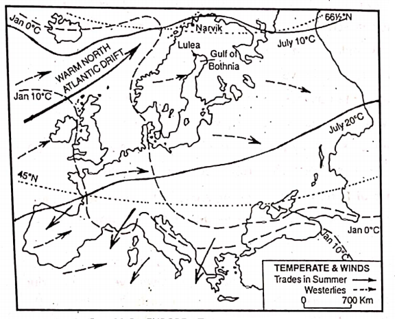
- Westerlies are permanent winds; so the rain is fairly well distributed.
- The altitude of the Alps mountains and the plateaus influence temperature conditions.
- Warm North Atlantic Drift along Western Europe keeps the seas ice-free.
Factors Affecting The Climate Of Europe:
Although the continent of Europe is small in size and lies in the temperate zone, its climate varies from one region to another because of the following factors:
1. Latitudinal Extent:
Europe extends from 35°N to 71°N latitude and thus, nearly the whole continent lies within the temperate zone. As the midday sun is never overhead beyond the tropical region, temperatures are never very high and decrease towards the poles.
So, the Mediterranean region of southern Europe is sunnier and warmer than the Tundra region of the extreme north.
2. Influence of the Sea:
Western and southern Europe lie beside the Atlantic Ocean and the Mediterranean Sea respectively. So, they have an equable climate with mild winters and warm summers. The severity of the climate increases eastwards due to greater distance from the sea. Thus, eastern Europe has hot summers and very cold winters.
3. Altitudinal factor:
Location of Highlands-The effectiveness of any wind depends largely on the layout of the highlands. Higher Alpine mountains and the highlands of Scotland and Scandinavia influence the climate by obstructing the air masses.
The altitude of the Alps mountains and the plateaus influence temperature conditions also.
4. Influence of Winds :
Nearly the whole of Western Europe is under the influence of the. south-west westerlies which blow all through the year. These winds cause rainfall throughout the year with a winter maximum, except in the south where trade wind blows in summer.
5. Influence of Ocean Currents :
Western Europe is comparatively warmer than the eastern coast of any continent in the same latitude. This is because the warming influence of the warm North Atlantic Drift is carried to the shores of Europe by the south-westerly winds.
The same warm current keeps the ports of Norway in north-western Europe ice-free even in winter. On the other hand, in the Gulf of Bothnia which lies away from the influence of the North Atlantic Drift, ports remain ice-bound in winter.
Chapter 11 Continent Of Europe Seasonal Conditions Of The Important Elements Of Climate In Different Parts Of Europe
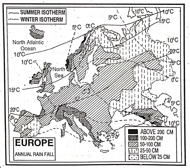
Temperature :
In general, temperature decreases from the south to the north. In summer when the sun is overhead in the Northern hemisphere, the sun’s rays are more direct in Southern Europe than in the north.
Thus Southern Europe becomes warmer than Northern Europe. Temperature decreases from 27°C in the south to below 15°C in the north.
In winter, due to the influence.. of the ocean current temperature remains around 10°C in the west. But in the north-east temperature drops too. -12°C.
Air Pressure And Wind
As the world pressure belts swing to the north in summer in the northern hemisphere, the southern hemisphere part of Europe comes under dry north-east Trade wind.
But moist south-westerly winds blow over the rest of the continent. In winter, world pressure belts shift to the south and the westerly replaces the Trade wind in the Europe.
Rainfall
Moistsouth-westerly wind gives rain all over the continent, but the amount decreases from west to east. In summer, the westerlies after causing rainfall (50- 100 cm) in north-western enter further inland where low pressure prevails due to higher 15°Ctemperatures.
Thus most of the rain (25 cm to 50 cm) in central and eastern Europe, comes in summer where rainy periods alternate with dry hot spells. Along the Norway coast, rainfall is 200 cm. In the Philly region, it is 100cm – 200cm.
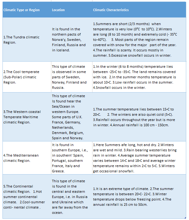
Chapter 11 Continent Of Europe Climatic Regions
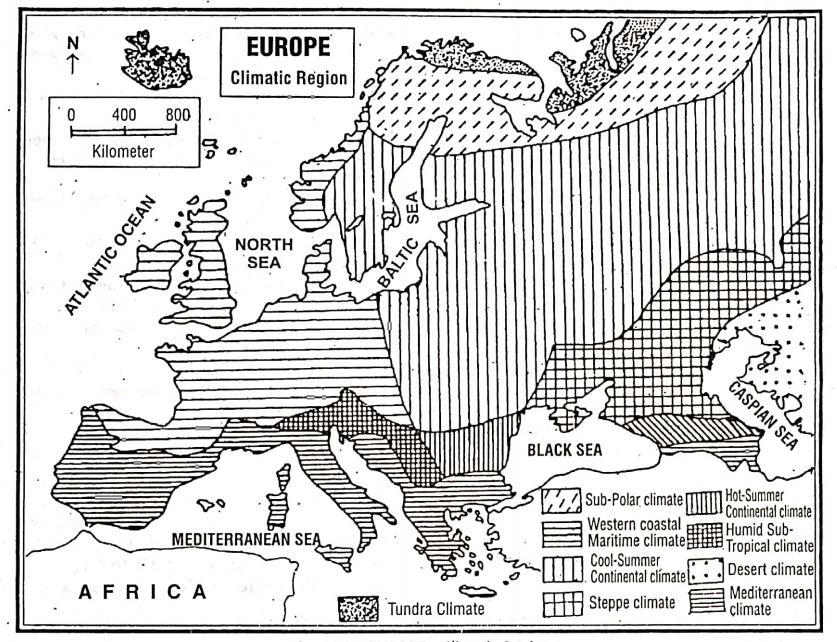
The continent of Europe can be divided into the following climatic regions on the basis of variations in temperature and rainfall.
Chapter 11 Continent Of Europe Natural Vegetation Of Europe
The characteristics of natural vegetation depend on climate. Natural vegetation in Europe has been greatly influenced by climate. The variety in climate has resulted in the variety of natural vegetation. Europe has five major natural vegetation belts, which are as follows:
The Tundra Vegetation
In extreme northern parts of Europe in Norway, Sweden, Finland, and Russia due to long winters (9/10 months), the ground remains frozen. So, only in short summer (2/3 months) when the surface thaws, Grass Tundra like mosses, lichens, and colorful flowers grow.
Bush Tundra namely birch, willow, alder, and juniper, grow in the south where the temperature is a little more. The region is named after the vegetation ‘Tundra’ means moss/ algae.
The Taiga Or Coniferous Vegetation
To the south of the Tundra lies the Taiga Region in Norway, Sweden, and Russia there is an extensive forest of softwood coniferous trees. Tall and straight trees like pine, fir, spruce, larch, etc. Due to severe Snowfall trees are conical with small needle-shaped leaves.
These trees yield valuable softwood for making wood pulp and for use as timber. Fruit-bearing trees are rarely found in this belt. This forest in Asia is called ‘Taiga’ which is the largest forest in the world.
Deciduous And Mixed Forest Belt
South of the coniferous belt in Central and Western. Europe there lies this belt extending from the British Islands to the central parts of Russia. This is a region of mixed forests.
Both coniferous trees and mostly deciduous trees which shed their leaves in Autumn or winter flourish. So, Autumn is referred to here as “Fall”.
The forest is also known as ‘Temperate Hardwood Forest’. Trees like oaks, ash, beeches, maples, chestnut, birch, and poplar are common and are mixed with pines.
Forests are found because rainfall is enough and the dry season is not long. These trees are not tall and there are a number of meadows or open ground amidst them.
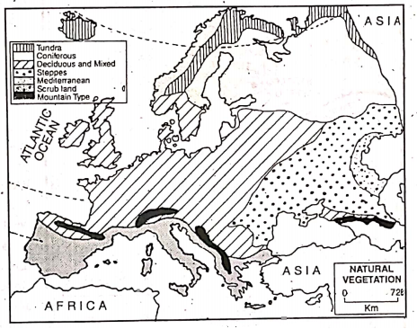
The Mediterranean Vegetation Belt
This belt is confined to Southern Europe along the Mediterranean Sea coast. It includes countries such as Southern France, Italy, Greece, etc. This belt has sunny warm (24°C) and dry summers and mild (80°C) and wet (75 cm) winters.
This type of climate supports evergreen trees and scrub which have special devices to combat long periods of drought and summer. heat. The trees grown here have long roots and thick bark to resist drought. They have broad, thick, and waxy or oily leaves. They are not tall and straight like the trees of the Taiga region.
The common trees are olive, cork-oak, cedar, laurel, chestnut, stone-pine, walnut, fig, citrus trees, and vine.
The Steppe Grasslands
The word ‘Steppe’ comes from the Russian word “Step” meaning “a vast treeless plain”. In the south-eastern and central part of Europe where rainfall is very low, there is an extensive temperate grassland known as the “Steppe grasslands”.
This region extends over the area of Southern Russia and the plains of the Danube in Romania and Hungary. The natural vegetation of this region consists of grasses and herbs.
However, along the banks of the rivers, where sufficient water is available, willow, elm, maple etc. are found. The short but soft, juicy grasses of the Steppes offer an ideal grazing ground.
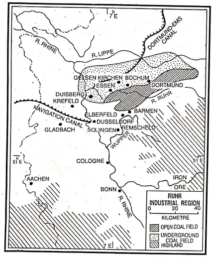
Chapter 11 Continent Of Europe Ruhr Industrial Region
Introduction:
The Ruhr industrial region of Westphalia in Germany is named after the Ruhr, a tiny tributary of the Rhine. It is one of the best industrial regions in Europe as well as the world.
The present Ruhr industrial region has more than 30 to 35 large cities which have merged to form the world’s largest ‘Industrial Conurbation’. (‘conurbation’ is a term meaning a continuous industrial area formed by the merger of many industrial cities and towns).
Location:
Ruhr industrial. the region is located at the confluence of the river Rhine and its tributary the Ruhr. The region once occupied the area between the Lippe and Ruhr rivers. At present, it extends up to the Wupper valley in the south and Munchen Gladbach in the southwest.
Boundary:
This region is bounded to the north by the river. Lippe; on the west by the Vosges and Rhine river; on the south and east by the Sayarland highlands.
Area and Extension:
The present Ruhr industrial region covers about 4600 sq. km area and stretches for 130 km in the east-west extension and 65 km in the north-south extension.
Physical Environment Of Ruhr Industrial Region
Physiographic characteristics:
The region is almost flat with an average elevation of around 250 meters above sea level and slopes gently from east to west. In some places are found small hills made of sands, stones, and pebbles deposited by glaciers in the ice age.
Rivers:
The Rhine is the principal river of the Ruhr industrial region. The Rhine is joined by its four tributaries (Ruhr, Lippe, Elms, and Wupper) flowing through this region. All of them are interlinked by canals and provide a good navigation system.
Climate:
The climate of this region is cool and temperate in nature. Well-distributed rainfall (Average annual rainfall is about 50 cm to 70 cm) and favorable temperature (Summer 15°C and winter around 0° -2°C) assist both agriculture and industry in the Ruhr region.
Soil:
Fertile alluvial soil along the riverbanks, podzol soil in the north, and chernozem soil in the south are found here which are good for agriculture.
Natural Vegetation:
Forests in this region have been filled and cleared to a considerable extent as agriculture, industry, and settlements have grown.
Planned afforestation has been done to control the pollution caused by the industrial region. Trees like oak, birch, elm, pine, fir, etc. are commonly found in the reserve forests of this region.
Economic Environment Of Ruhr Industrial Region
Agriculture:
This region is dominated as an industrial region and is not very much developed in agriculture. However, mixed farming is practiced to satisfy the demand of urban people. Crops such as wheat, barley, potatoes, sugarbeet, and a variety of vegetables, fruits, and flowers are grown in this fertile plain.
They supply most of the agricultural needs of the industrial towns. Cattle and sheep are also reared to produce milk, meat, wool, etc.
Minerals:
The greatest asset of the Ruhr region is the presence of 130 thick seams of excellent cooking coal and best quality anthracite and bituminous coal. It accounts for 80% of the total coal production of Germany. This plays an important role in the development of industries here.
So, coal is the lifeline of this region. Other important minerals of this region are lead, zinc limestone, and low-grade iron ore. Petroleum is also mined in some areas.
Transportation system:
Ruhr industrial region is well developed in different modes of transportation such as roadways, railways, and waterways. The Rhine is the busiest and most navigable waterway in Europe.
This river along with its tributaries, namely the Ruhr, the Lippe, and the Dortmund-Ems and Lippe canals provide cheap access to the North Sea. There is also a dense network of rail and roads in the region.
Industries:
This is the most important industrial region of the world. The region accounts for more than 80% of the steel output of Germany. It is also the leading manufacturing district for coal by-products, metal products, machinery, textiles, and chemicals.
Causes For The Development Of The Ruhr Industrial Region
Factors favoring the growth of industries in the Ruhr region are as follows:
- Availability of High-grade local coal: There is a large-excellent coalfield (Westphalia) in between Rhine, Lippe, and Ruhr rivers. This is the lifeline of this region.
- Raw Materials: Iron ore which is found in Siegerland, also imported by waterways from France (Lorraine), Sweden, and Spain. Limestone, though available in this region, is also imported.
- Excellent Transportation System: Roadways, railways, and waterways, especially rivers and canals of this region serve excellent transportation network essential for the such industrial growth of this region. They also facilitate the export of finished goods.
- Power Resources: Sufficient supply of thermal power from coal and cheap hydel power which help the industrial development of this region.
- Water Resource: Clean and soft water required in industries is provided by the Ruhr, Rhine, and Wupper. To ensure water supply, reservoirs have also been constructed on the rivers.
- Local Skilled Labour: Plenty of very skilled and experienced labor is locally available. This has led to a high degree of specialization in industries.
- Adequate Capital: Germany is one of the well affluent countries in the world. There is no dearth of capital from the rich local traders for the development of the industries in the early phases.
- Improved Technology: Germany is noted for its technological advancement. So, the Ruhr region is also facilitated by it.
- Dense Population/Market: Ruhr region is densely populated. So laborers required for industrial growth as well as demand and market for the finished goods are easily available.
- Government Policy: The German government has always encouraged research to develop new and more efficient techniques of industrialization.
Industries And Industrial Centres Of The Ruhr Region
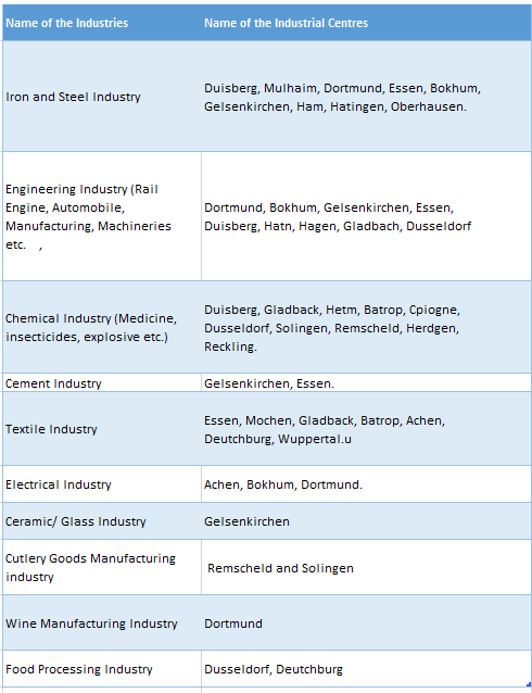
Queen of the Ruhr:
The most important steel works, for this reason, are at Essen which is located in the Ruhr heartland. The city known as the ‘Queen of the Ruhr’, boasts of the iron and steel industry run by the famous company ‘Krupps and Demag’.
Manchester of Germany:
Gladbach is the most important textile center of the region and is famous as the ‘Manchester of Germany’.
Ruhrgrebeit:
The heart of the Ruhr industrial region called the ‘Ruhrgrebeit’ extends from Dortmund to Duisberg and accounts for the production of 80% of the country’s steel.
Population and Settlement:
Due to the development of transportation and industries, this region is densely populated. Settlements are found to be uniformly thick right through the region from south to north.
Important cities:
Important towns and cities of the Ruhr industrial region are-
- Dusseldorf,
- Duisberg,
- Dortmund,
- Essen,
- Wuppertal and
- Cologne.
Chapter 11 Continent Of Europe London Basin
Introduction:
The lower Thames Basin lies in the south-eastern corner of the United Kingdom, and is called the ‘London Basin’. The word ‘Basin’ means ‘lowland formed by a river’.
London, the capital of England as well as the United Kingdom is located in a saucer-shaped lowland surrounded by highlands, except for a small portion in the east.
This region of lowland is formed by the Thames river as such the basin named the capital city of London is called London Basin’.
Location :
London Basin is located in the southeastern part of Great Britain in the lower Thames river basin. The river Thames flows through nearly the centre of the region from the west to the east.
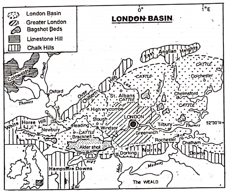
Boundary:
Except in the east, the London Basin is surrounded by highlands. It is bordered on the north by Chiltern Hills and the south by North Downs and Hampshire Downs.
The western boundary of the basin is the Berkshire Downs and White Horse Hills. At the eastern boundary where the land is flat, the Thames river flows over it to the Dover Strait.
Area and Extension:
London Basin comprises about 7750 sq. km. The core of the London Basin is represented by the Greater London area, stretching from Enfield to Epsom and from Oxbridge to Upminister, surrounded by the chalk dip slopes.
Population:
The population of the London Basin is about 12.5 million.
Physical Environment Of London Basin
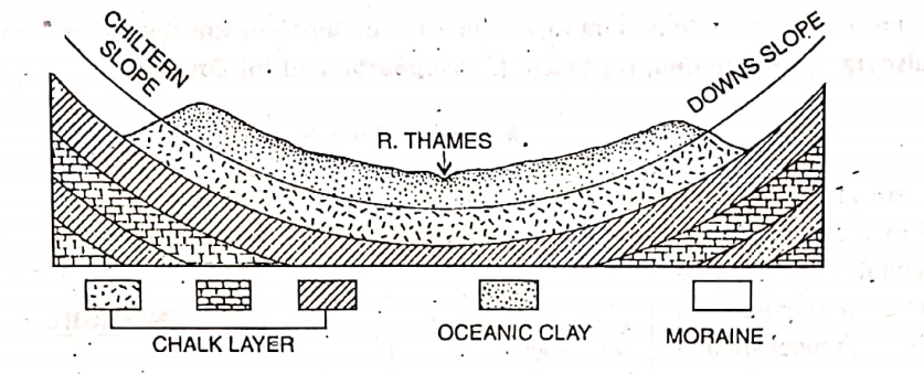
Physiographic Characteristics:
The London Basin is a triangular shallow depression or trough formed by a downfold in the chalk upon which has been deposited sands, gravels, and clays. The basin is not evenly flat Glacier-borne stones, and pebbles have accumulated in places to form an undulating surface.
The bordering hills have steep slopes and are made of chalk and limestone. The height of the North Downs varies between 270 to 320 meters while that of Chiltern Hills in the north varies between 235-250 meters.
London Basin may be sub-divided as follows :
- The Chiltern Dip Slope,
- The North Downs Dip Slope,
- The Middle Thames valley,
- The Lower valley of the Kennet,
- The Lea valley,
- Lower Thames Estuarine Zone and
- Greater London.
Rivers:
The principal river of the London Basin is the Thames. It rises in the Cotswold Hills lying in the west and enters the region through the Goring Gap, between White Horse and Chiltern Mountains.
Then the river flows eastward and drains into the Dover strait. Many hill torrents have joined the Thames river, such as Lea and Roding from the north; Wey and Moly from the south.
Climate:
The climatic type of London Basin is popularly known as the ‘West coast maritime climate’ or ‘British type of climate’. In general, it has warm summers (17°C) and cold winters (4°C). Moist and cool climate prevails in this region throughout the year.
Rainfall is basically cyclonic with a winter maximum. It ranges from 75 cm on the crest of the North Downs to 60 cm on the Thames side. Snowfall occurs in winter.
Soils:
Once the London Basin was covered by a shallow sea where sediments like the ‘London clay’ were deposited about 70 million years ago.
Later when the basin was raised above the sea, patches of sand called ‘Bagshot Sand’ covered this clay in some places. At the margins of Chalk hills was deposited a pebbly and sandy soil called ‘Woolwich Sand’.
Natural Vegetation:
Owing to dense settlement, the growth of industries, and urban centers the original natural forests have been destroyed. Only on the highlands, do coniferous trees like oak, pine, and beech grow. Due to little rainfall, there are some grasslands in these basins.
Economic Environment Of London Basin
Agriculture:
As the London Basin is very densely populated and highly industrialized, agriculture is restricted only to a small extent. To fulfill the local demand, advanced, mechanized mixed farming is practiced in some parts of this region. Varied crops are cultivated on small farms.
Vegetables i.e. potatoes, turnips, carrots, cauliflowers, cabbages, tomatoes, fruits, and flowers are produced and which are sent by trucks to the cities.
So this type of farming is also called ‘Truck farming’. Some cereals like wheat, barley oats, etc. are also produced in the north and west of the London Basin.
Animal Husbandry and Poultry Farming:
On the pastures found in the Chiltern and Downs Highlands and slopes of the mountains cattle and sheep are easily reared. Chicken, turkey, etc. are supplied from poultry farms.
Thus sufficient milk and milk products (butter, cheese, etc.), meat, and wool are also produced here. In the dairy industry, the region is quite developed.
Fishing:
Fishing is also practiced in this region.
Transportation System:
There is a good network of modern roadways, railways, and waterways. London basin is an important center of International air routes. There are five airports, such as Heathrow, Foulnes, Stansted, Black bush, and Croydon.
Heathrow is one of the busiest airports in the world. The underground and overground railway is very developed in London. London is an important river port also.
Minerals:
Other than some limestone and sand, there is no other mineral in this region.
Industries:
The London Basin is one of the most industrialized regions of the world. It is the principal industrial and trading center of the United Kingdom.
After the ‘Industrial Revolution’, rapid industrialization has taken place here. The following factors are responsible for such tremendous development in industry and trade in London Basin.
- Abundant Supply of Raw materials: The abundant supply of raw materials from its overseas colonies is responsible for the industrial development of this region.
- Nearness to the London Port: Being located at the center of the region, the port of London helps in the easy import of raw materials and export of finished goods.
- Developed Communication/Transportation System: Railways and roadways meet at London country. The benefit of good communication has naturally developed industry and trade in London.
- Skilled and Experienced Labourers: The dense London Basin has numerous cheap labors who have been skilled, experienced, and related to industry over a long period of time.
- Administrative Facilities: London is the main administrative headquarters of U.K.. has naturally more importance in the development of industry and trade.
- Availability of Electricity/Power Resource: Sufficient supply of power resources or electricity helps to develop industries in this region.
- Dense Population /Market Facilities: Dense population of the London Basin helps to supply sufficient cheap labor and it also increases the local demand for industrial goods which helps to develop a marketing system and economic prosperity.
- Advancement in Science and Technology: Applying modern techniques and machinery, quality and productivity has been increased.
- Easy availability of capital: London is a famous banking center. Therefore for the development of industry and trade the required capital and economic cooperation is easy. available.
- Nearness to the Industrially-Developed Countries: Across the Thames estuary on the other side of the ‘Strait of Dover lies the industrially developed countries of Germany, France, Netherlands, etc. of Europe. This developed economic environment sufficiently helps in the development of industry and trade in the region.
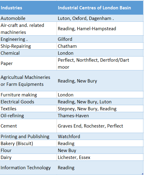
Industries And Industrial Centres Of London Basin
Population and Settlement:
Due to its economic prosperity, London Basin has become a densely populated area. It is the most densely populated region of the U.K. with more than 1.25 crore people.
Numerous people live here because of developed communication, growth of agriculture and industry, and attraction of the capital.
Major Cities
1. London:
London is the capital of England, as well as the United Kingdom, and the leading city of the British Commonwealth and Empire. London is not only the largest city in this region but also the main city and port of the whole of U. K.
It is the third largest city in Europe after Paris and Moscow. It is an industrial and trade center. It is an important international airport center also.
Though London is a river port yet it is famous as an Entreport, as it imports materials which it again exports. For example, After importing tea, coffee, spices, etc: from various countries, it processes them and then exports them to different countries in Europe and other continents.
Many tourist places lie in London. Near London lies the famous Greenwich Observatory in the suburbs of Greenwich, over which extends the meridian of 0° longitude or the Prime Meridian. London is the most cosmopolitan city in the world.
2. Reading :
Reading is located at the confluence of the Thames and the Kennet is an industrial town. Engineering, biscuit, textile, etc. factories are located here.
3. New Bury:
It is located on the banks of the Kennet river. It is a busy market center. It is also famous for engineering, flour milling, and cotton textile factory.
4. Others:
Other important towns include Croydon, Chelmsford, Chatham, Slough, St. Alban, and Rochester.
Chapter 11 Continent Of Europe Polder Land
Introduction:
The term ‘Polder land’ is derived from the word ‘Polder’ which means reclaimed from under the sea’. So Polder land is actually low land that has been reclaimed from the shallow submerged lands of river marshes or the sea and is surrounded by dykes.
Polder land:
In the Netherlands, an area that has been reclaimed from the Zuider Zee (formerly, a landlocked inlet of the North Sea) and has been surrounded by the dykes to protect it from the seawater is called ‘Polder land’.
It is drained by pumping the water into canals and has made gradually very much fertile for agriculture.
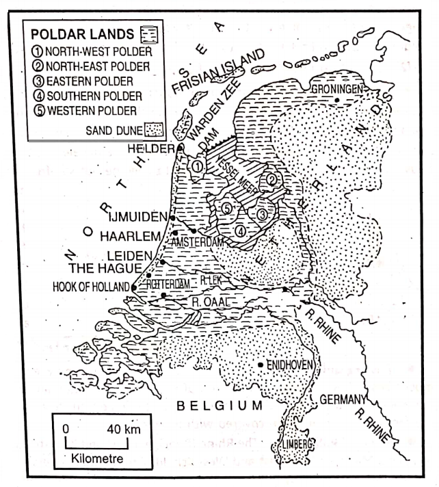
Location of Polder Land:
The Polderlands latitudinally extend roughly between 51° N latitudes in the south and 54°N latitudes in the north and longitudinally between 3°E longitude in the west and 7°E longitude in the east.
The boundary of Polder land:
The Polder lands are bordered on the north and west by the North Sea, on the south and southwest by Belgium, and on the east and southeast by the remaining parts of the Netherlands.
Area and Extension:
The Polder lands cover about 16,700 sq. km and made up around 30% of Holland (meaning ‘the lowlands’) or the Netherlands. Nearly 70% of the Polder lands lie below sea level.
How a Polder land comes into being?
The reclamation of Polder lands started in the Netherlands, in ‘the eleventh century. Then the reclaiming process of Polder land was primitive. It has been modernized with the advancement of technology.
There are more than three thousand Polders in the Netherlands. Among these, Zuider Zee is the largest. Most modern and important projects on reclaiming polders are-
- Zuider Zee Project and
- Zeeland Project.
1.Zuider Zee Project was started in 1918. A dyke has been made to form a lake called Ijsselmeer from which lands have been reclaimed at different stages such as-
- North-west Polder; It was in 1st phase and completed 1927,
- North-East Polder (1942),
- East Polder (1954),
- West Polder(1980),
- South Polder (1980) etc.
2. Zeeland Project is located in the southern part of the Netherlands.
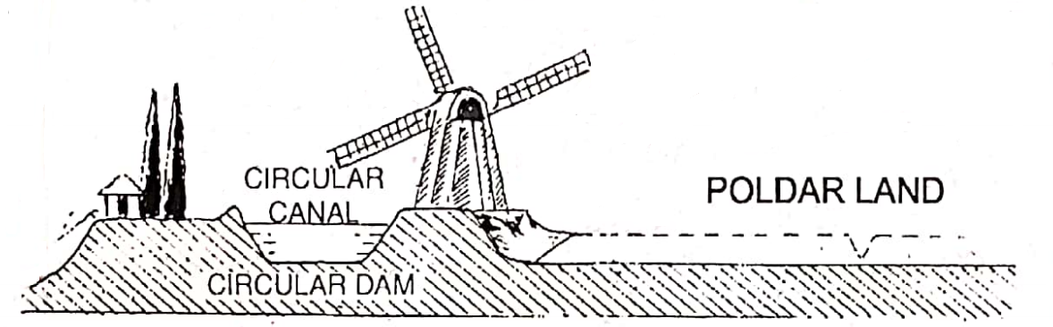
The main stage of reclamation of marshy land or parts of shallow seas is to seal the area with concrete dykes on all sides. Inside the circular dykes, there are rings of canals to drain the water.
After that musky water is pumped into the enclosure. As the sediment settled down, the water is pumped out by windmills (now mainly electricity operated).
Thereafter, the alluvium dries up and then the land is left to become out salt-free for a few days. After that, the land is used to cultivate different grasses such as hey, clover, alfalfa, etc. for fodder.
When the land becomes salt-free and favorable for cultivation different crops and flowers are cultivated.
Physical Environment Of Polder Land
Physiographic Characteristics:
The entire region is not only flat but also very low and mostly lies below sea level. Some parts of this region are located about 7 to 10 feet below sea level. If stagnation of rainwater occurs, it is pumped out to the draining canals. Most of the areas of this region are covered with marine clays.
Rivers of Polder land:
The Rhine (Principal river) and its distributaries such as the Waal (Val), Lek, Maas, and the East and West Schelde are the main rivers of Polder lands. All these rivers form deltas as they enter the North Sea. The Ijssel, another distributary flows into the Ijsselmeer.
The climate of Polder land:
Polder land is located in the cool temperate climatic region, but the climate is moderate because of the warm North Atlantic Drift. The average winter temperature is 3°C and the average summer temperature is 16°C. In the interior, summers are slightly warmer and winters are slightly colder.
Here the south-westerlies bring rainfall throughout the year. The average annual rainfall is around 75 cm with a winter maximum.
Soils of Polder land:
Alluvial soils are found along the banks of rivers. Most of the soils of Polder lands are saline clay.
Natural Vegetation of Polder land:
In this man-made land, there is simply no natural vegetation. The coastal dunes are planted with sand-binding grasses, reeds, and pines. Here trees like oak, birch, and grasslands are very common.
Economic Environment Of Polder Land
Agriculture:
The Polder lands are the richest agricultural regions of the Netherlands. With a view to decreasing the salinity of soil in the new polders, grasses like hay, clover, alfalfa, etc. are cultivated. These nutritious grasses are used as fodder.
In the old salt-free Polder lands different crops such as wheat, barley, eat, potato, mustard, and flax as well as strawberries and other fruits are cultivated. Farmers mainly practice ‘mixed farming’, where crop cultivation and cattle rearing are practiced under the same farm.
Here in the vast rolling tracts, different colorful flowers such as Tulips, Cosmos, Gladiuli, etc. are grown. Moreover, in the cold regions with less sunshine, vegetables and also flowers are grown, in ‘Green Houses’.
Livestock Raising:
Moderate temperature, year-round rainfall, and clayey soil are more suitable for grass than to crop farming. So, pasture dominates. Cattle are reared on rich pastures where hay, clover, and alfalfa grew abundantly.
Thus dairy farming is the keystone of Dutch activities and it provides butter and cheese for which the Netherlands is internationally famous.
Fishing:
Fishing is also important in the new Polder lands. Ijsselmeer (A lake, North section of former Zuider Zee which receives river vessels) has freshwater fisheries while shrimp fishing and cultivation of oysters and mussels are important in the Zeeland.
Mineral Resource:
The region is not so rich in mineral resources. The principal mineral of Polder land is natural gas. At Groningen, there is a large reserve of natural gas. It is one of the largest gas fields in the world. Some mineral oil is available at the Hague.
Industries:
Polder land is famous for its industries-Iron and steel, Petro-chemical, electronic and electrical goods (Phillips Company), ship-building, dairy, food-processing, cotton-textile, paper, leather, and perfumery or cosmetics industries have developed here.
Important industrial centres are Amsterdam, Rotterdam, Groningen, The Hague, Harlem, Leven, Ijmuiden, Leiden, Flashing etc.. Amsterdam is world-famous for its diamond cutting and polishing.
Transportation Sysem:
The transportation system in Polder land is well-developed. It has an excellent network of modern roadways and railways. Rivers and canals provide easy means .of communication.
The circular dykes are also used for transporting the estuary of river Lek, the largest port of the region, and Amsterdam transportation. Rotterdam, located at the est port of the region, Amsterdam is also famous as a port.
Population:
Polder land is densely populated because of its developed transportation system, advanced agricultural and industrial economy, and most modern way of livelihood.
Major Cities Of Polder Land
Amsterdam:
Amsterdam is the principal and capital city of the Netherlands. It is also an important port and industrial center. It is famous for electronic goods, shipbuilding, cigarette and cigar making, and diamond cutting.
It is popularly known as ‘Venice of the North’ because of its navigation and scenic beauty.
Rotterdam:
This is the busiest port in the world and an important town in the Netherlands. It is also known as ‘Europort’ as most of the European trade is carried through this port.
The Hague:
The Hague is the seat of the Parliament and of the ‘International Court of Justice’.
Others:
Other important cities are Eindhoven, Groningen, and Leiden.
