Chapter 10 South America
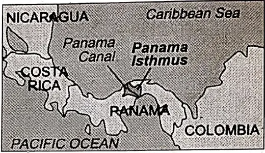
Introduction Of South America: The Continent of South America is situated to the south of North America. Once it was connected to North America through the ‘Isthmus of Panama’.
In 1914, South America becomes separated from North America by constructing the Panama Canal cut through the Isthmus of Panama. The continent was unknown to the Europeans for a long period. Therefore, when the continent was discovered by the Europeans, they called it as ‘New World’.
Read and Learn all WBBSE Notes For 8 Class Middle School Geography
South America forms a part of Latin America which includes the states of Central America south of the United States and the West Indies. Latin was the ancient language used by Romans in the past. Modern languages of Spanish, Portuguese, Italian, and French are derived from Latin.
“WBBSE Class 8 Geography Chapter 10 notes, South America”
| Class 8 General Science | Class 8 Maths |
| Class 8 History | Class 8 Science LAQs |
| Class 8 Geography | Class 8 Science SAQs |
| Class 8 Maths | Class 8 Geography |
| Class 8 History MCQs | Class 8 History |
People from southern Europe speaking these languages settled in this part of the Western Hemisphere. Therefore, this part of the Western Hemisphere is called, ‘Latin America’.
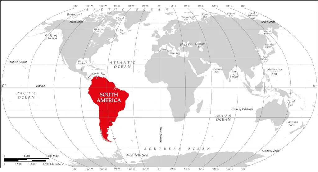
Location: South America is situated between 81°21′ West longitude in the west and 34°50′ West longitude in the east; and 12°28′ North latitude in the north and 56° S latitude in the south. Since nearly. 85% of the continent falls within the southern hemisphere, it is called a ‘Southern Continent’.
The continent is also called the ‘Continent of Western Hemisphere’ as it is entirely located to the west of 0° longitude. South America is a triangular-shaped continent that is wider in the north and gradually tapers to a point in the south. It stretches for 7562 km from north to south and for 5310 km from west to east as its widest part.
Geography Class 8
Boundary: The continent of South America is bounded on the east by the Atlantic Ocean, on the west by the Pacific Ocean, on the north by the Caribbean Sea and the Panama Canal and on the south by the narrow Drake Strait and Antarctic Ocean.
Tierra del Fuego, an igneous island, lies off the southeast coast of South America and is separated from the mainland by the Strait of Magellan. Cape Horn is the southernmost tip of the continent.
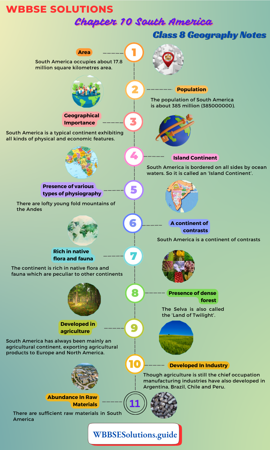
Area: South America occupies about 17.8 million square kilometres area. It is the fourth largest continent of the world according to its size and population. Its area is six times greater than India.
Population: The population of South America is about 385 million (385000000).
Geographical Importance: South America is a typical continent exhibiting all kinds of physical and economic features. These are as follows:
Island Continent: South America is bordered on all sides by ocean waters. So it is called an ‘Island Continent’.
Presence of various types of physiography: There are lofty young fold mountains of the Andes; the Great Central Plain covered by the Llanos, the Selves, the Gran Chaco and pampas; the double eastern highlands of Guiana and Brazil and the deeply indented coastline of the southern end.
“Class 8 WBBSE Geography Chapter 10 notes, South America study material”
A continent of contrasts: South America is a continent of contrasts. The hot wet equatorial forests of the Amazon Basin and the Atacama Desert of Peru-the driest of the world, the high barren plateau of Bolivia, the temperate grassland of Argentina and the Mediterranean coast of Chile-all differ widely in climate and vegetation.
Rich in native flora and fauna: The continent is rich in native flora and fauna which are peculiar to other continents. The hevea brazillensis which yields rubber is a native tree of South America. Native animals include the alpaca and vicuna which are prized for their wool and the llama.
Presence of dense forest: The entire northern part of the continent is covered by dense evergreen rain forests, called ‘Selvas’ through which light cannot reach inside. The Selva is also called the ‘Land of Twilight’.
Developed in agriculture: South America has always been mainly an agricultural continent, exporting agricultural products to Europe and North America.
Developed In Industry: Though agriculture is still the chief occupation manufacturing industries have also developed in Argentina, Brazil, Chile and Peru.
Abundance In Raw Materials: There are sufficient raw materials in South America which are needed for different industries, such as:
Minerals like:
(1) Iron ore,
(2) Copper ore,
(3) Bauxite;
Crops like:
(4) Coffee,
(5) Cocoa,
(6) Sugarcane,
(7) Rubber,
(8) Cotton etc.;
Animal-based raw materials like:
(9) Wool,
(10) Meat,
Leather and forest-based raw materials, like:
(11) Timber.
Potential In Power Resource: Though there is a scarcity of power resources there is high potentiality in the generation of hydel power by the turbulent rivers and thermal power.
Prospective continent: With its immense resources awaiting development, South America’s future holds great promise.
Chapter 10 South America Physical Features of South America Physiographically
South America may be divided into five divisions-
- The Western Mountains,
- The Northern Plateau,
- The Eastern and The Central Highlands,
- The Central Plains and
- The Coastal Plains
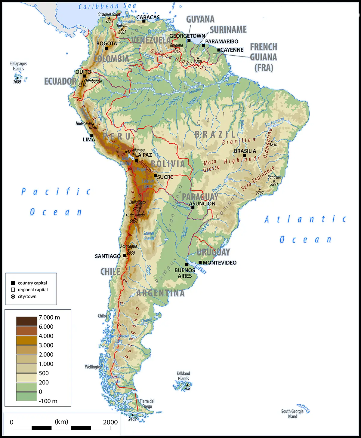
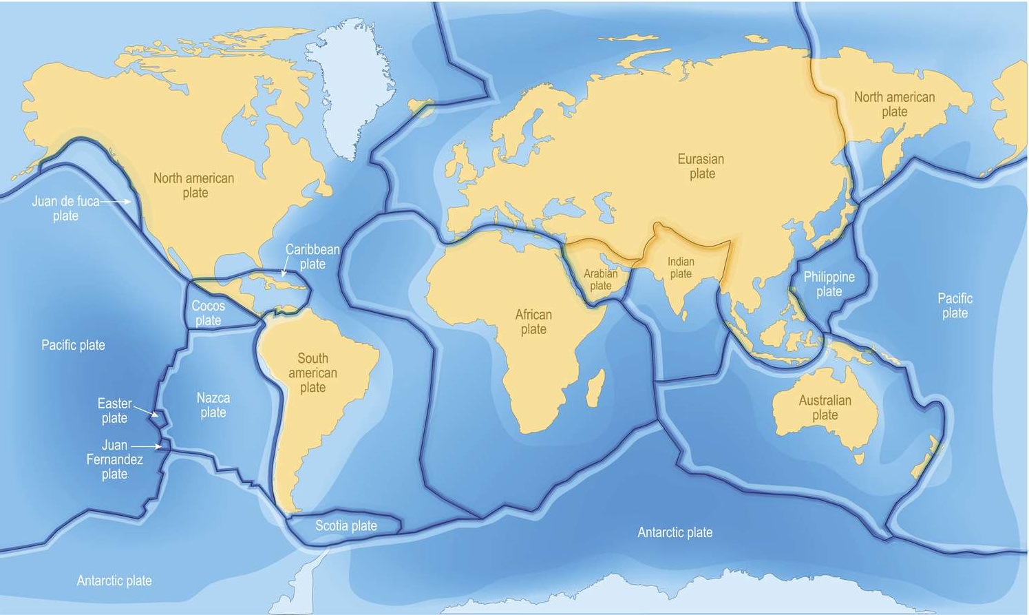
The Western Mountains: The Andes Mountains, also known as the ‘Western Cordilleras’ is the most prominent feature of the continent. The Andes Mountains extend continuously parallel to the west coast for a distance of over 7250 kilometres.
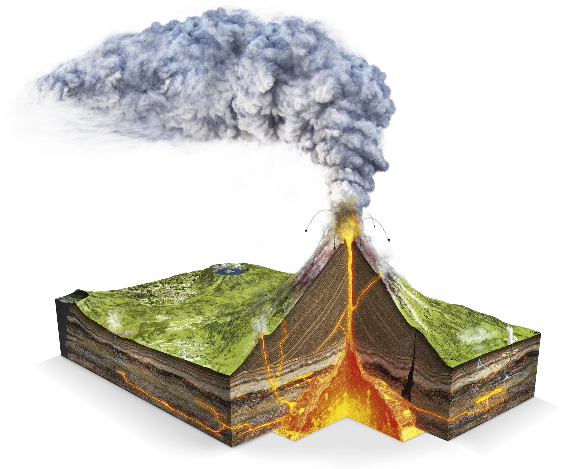
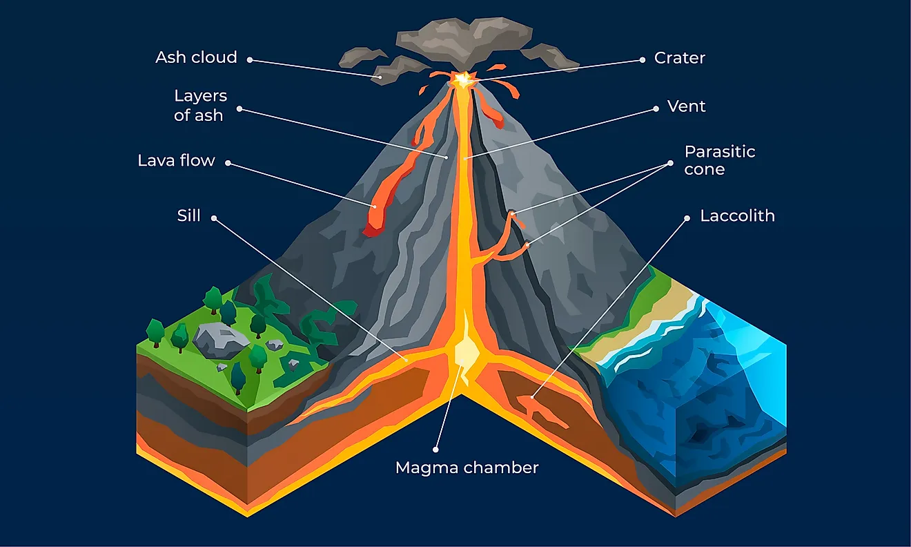
It is the longest mountain in the world. It is broad in the north in Bolivia (about 640 kilometres) and gradually becomes narrow in the south. The mountains contain high peaks such as Mt. Aconcagua (7021 meters), (6277 m) and Cotopaxi Chimborajo (5896 m).
Chimborgo is the highest active volcano in the world. Cotopaxi is the second-highest active volcano in the world. Aconcagua is the highest peak of the Andes. There are many volcanic peaks in the mountain ranges. The high peaks are permanently covered with snow and ice.
The Andes is the world’s longest as well as the second loftiest young fold mountains. The Andes mountains is frequently affected by earthquakes.
The Andes mountains consist of two or three parallel ranges with basins of plateaus between them. Central cordillera runs through the middle of Colombia in a north-south direction.
“WBBSE Class 8 Geography Chapter 10, South America study guide”
The Occidental mountain range lies west of central California and the Oriental mountain range lies east of the central Cordillera. The southern part of the Oriental mountain range is known as the ‘Real mountain’ which stands along the border between Chile and Argentina.
Lake Titicaca located on the Andes along the border between Peru and Bolivia is the highest lake (3800 m) of the world and also the largest lake of America. The Uspallata pass lying to the southwest of Aconcagua is the only break in the continuous chain of the Andes.
The Northern Plateau Region: The region that extends from the Andes in the western part of the continent to the Atlantic coast in the east is called the Northern Plateau Region.
Due to the processes of erosion and denudation by rainfall, river and wind, the plateau has been reduced to a low height. This region covers Venezuela, Guyana, Surinam and Guiana and is also known as Guiana s 48 Highland. In Venezuela the plateau is highest where Merida is the highest mountain and the highest peak is Marta (5105 m).
The Central and Eastern Highlands: There is another highland in South America. In the east of the continent, it is known as ‘Brazilian Highland’ and in the central region of the continent as ‘Mato Grosso’,
Pacific Ocean Plains Ocean Eastern High Land Atlantic which, actually, links the Andes Mountain in the west and the Brazilian Highland in the east. Brazilian Highland slopes very steeply to the Atlantic coast in the east, while it descends gently to merge with the Central Plains in the west. The greater part of the plateau is occupied by the ‘Campos’ grassland.
The Central Plains Or Lowlands: The Central Lowlands or Plains lie between the Eastern Highlands and the Andes. They consist of four areas from north to south. These are as follows:
The Plains Of The Amazon Basin: This is the largest and northernmost part of the plain. This plain is located in the equatorial region. So a major portion of this plain is covered by dense evergreen rain forests called ‘Selvas’. The slope of this region is from west to east.
The Plains Of The Orinoco Basin: The Orinoco river basin in Venezuela and Colombia has formed a narrow plain extended in the southwest to northeast direction. ‘Llanos’, the tropical grassland covers this plain.
The Plains Of The La-Plata Basin: La-Plata, the most important estuary of the Parana -Paraguay and Uruguay river of the southern part of south America has formed another narrow plain extending from the north to the south through the countries of Bolivia, Paraguay, Uruguay and Argentina.
The Pampas Plain: An extensive temperate grassland called ‘Pampas’ lies to the south of the La-Plata in Argentina. In the north the grassland where some deciduous trees are found with scattered presence of scrubs it is known as ‘Granchaco’. The southern part of the Pampas is very dry and has formed the Patagonia, Desert.
The Coastal Plains: There is a very narrow coastal strip bordering the Pacific Ocean coast of Ecuador and Colombia as the Andes rise very steeply from the shore of the Pacific Ocean. The coastline of South America is almost smooth except in the southwest where it is broken. Many fiords have formed by glacial erosion through which the sea water enters the continent.
Many islands are also found in the ocean, such as the Galapagos islands lie off the coast of Ecuador, Juan Fernandez lies off the coast of Chile; Tierra del Fuego and Falkland island lie off the coast of Argentina and Trinidad Tobago, Barbados and Grenada islands lie off the coast of Venezuela.
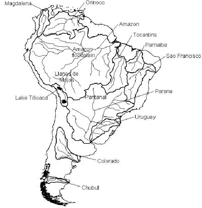
Chapter 10 South America Drainage System Or Rivers Of South America
Many rivers are found in the continent of South America. Rising in the Equatorial regions most of the rivers of the content supply more water.
The plateau of Mato Grosso, located in the central part of South America, acts as a water divide between the northern and southern parts of the continent. Most of the rivers of the continent have organised either in the Mato Grosso or in the Andes and flow eastward to the Atlantic Ocean.
The characteristic features of the rivers or drainage system of South America are as follows:
- Most of the rivers of South America are rain-fed and originate from the Equatorial region of the continent.
- The rivers are perennial as they are fed by snow or equatorial convectional rain. Some of these rivers are suitable for the generation of hydel power.
- Most of the rivers are long in length and large in volume.
- Most of the rivers originated from the Mato Gross plateau or the Andes mountains.
- There are some west-flowing rivers which originate from the Andes mountains are short in length.
- Except for the Orinoco river, no other river has formed a delta near its mouth.
According to their direction of flow rivers of South America may be grouped into following categories :
- East flowing rivers,
- North flowing rivers,
- South-flowing rivers and
- West flowing rivers.
Important Rivers Of South America:
| Types Of The Rivers | Name of the Rivers |
| East flowing Rivers. | The Amazon, Orinoco, Sao-Francisco |
| North flowing Rivers | Madeira, Purus, Tapajos, Xingu, Araguaia, The Magdalena. |
| South flowing Rivers | Paranaiba, Parana, Paraguay, Uruguay, Rio-de-la Plata, Salado, Colorado,Rio-Negro, Chico, Rio Branco. |
| West flowing Rivers | Short but turbulent rivers which originated in the Andes and flow into the Pacific Ocean. |
East Flowing Rivers:
(1) The Amazon River System: The Amazon river, the chief river of South America is the World’s greatest and mightiest river. This is the longest river of South America and the Second longest river of the world (6447 km). In 1541, the great Spanish traveler ‘Orellana’ called this river as ‘Amazons’.
It owes its name to the race of female warriors called the ‘Amazons’ of Greek legend. The river basin is also called the ‘Amazonia’ i.e. ‘the land of the female warriors’. The river basin covers about 7:04 million square kilometres which is the world’s largest river basin.
The source of the river Amazon is considered as a lake which is located on the top of the Andes. Another opinion is that the river Amazon originated from Mt. Mishmi (5597 m) on the Andes in Peru and then flows northward.
Rising as the ‘Maranon’ in the central Peruvian Andes, it is joined by another two headstreams including the ‘Napo’ and the ‘Ucayali’. Then it escapes from the Andes through narrow gorges and flows eastward over the lowlands to meet the Atlantic off north-eastern Brazil.
The river is fed by more than one thousand tributaries flowing down from Peru, Bolivia, Ecuador, Colombia, Venezuela and Brazil. The seven tributaries namely Madeira, Jurua, Purus, Japura, Tocantins, Negro and Xingu are longer than 2000 kilometres.
The Madeira (3350 Km long) is the longest tributary that flows from Bolivia. On the other hand, the Negro (2253 km long) though shorter in length, is the largest tributary of the Amazon.
Rising in the equatorial regions of Colombia, it supplies more water to the Amazon than any of the other tributaries. It is estimated that 20% of all the water that runs off the Earth’s surface is carried by the Amazon.
The width of the river varies from 1.5 km to 14 km and near the mouth it is 80 km. So it is no wonder that the Amazon is called the ‘River Sea’. The large volume of freshwater discharged by the river makes the seawater less salty for more than 160 km from the shore.
“WBBSE Class 8 South America notes, Geography Chapter 10”
The river Amazon is navigable up to 3200 km from its mouth. A large volume of water with great velocity is discharged through the wide mouth of the Amazon river to the Atlantic Ocean.
The mouth of the Amazon river is quite wide and water from the ocean enters the river during high tide. Ocean currents are also very strong in this region. Due to such conditions, no delta has been formed in the mouth of the Amazon river.
The Amazon river is called World’s largest river due to the following causes :
- The Amazon river is the second longest river (6447 km) of the world (the Nile is the longest, 6671 km).
- The Amazon basin is the largest river basin of the world (7050000 sq. km)…
- This basin is located in the Equatorial climatic region. Heavy
- As the location of the Andes in the way of northeast trade winds, moisture-laden air gets obstructed by the mountain, causing heavy precipitation.
- The discharge of water per second is 209000 cubic metres.
- There are about more than 1000 tributaries and innumerable distributaries of the Amazon. They are quite long.
(2) The Orinoco River System: The name ‘Orinoco’ is derived from the American word meaning ‘Place of Paddle’ i.e. navigable place.
This river is flowing in the northern part of South America. After rising from the southwestern Guiana Highlands of Venezuela, the Orinoco flows for some 2736 km to meet the Atlantic where it forms a delta.
After coming down from the highland the river has crossed the dense forests, grasslands, swamps one after another flows north-eastward along the edge of the highland in a giant arc and then finally has drained into the Atlantic Ocean.
Important tributaries of the Orinoco river, that have originated either in the Andes or in the Guiana Highlands are- Meta, Guaviare and Caroni. The Carrao, a tributary to the river Caroni, has formed the highest waterfall of the world- the ‘Angel’ waterfall. It is about 979 metres high (3212 feet).
Casiquiare, another tributary to the river Orinoco has joined river Negro-the tributary to the Amazon river.
“Class 8 WBBSE Geography Chapter 10, South America easy explanation”
(3) Sao-Francises: Sao-Francisco is another important river of South America. This river is about 3200 km long. It originates in South Central Minas Gerais state of Eastern Brazil, flows north, north-east and eastward and falls into the Atlantic Ocean.
It is the main river of eastern Brazil. The river, an entirely Brazilian river, is called the ‘River of National Unity’ by the Brazilians because of its importance in navigation and as a source of hydel power.
North-flowing rivers:
(1) Madeira: Maderia is a river of west Brazil and it is the most important tributary of the river Amazon. It is about 3350 km long and formed by the confluence of Bolivian rivers Mamore and Beni at the Brazilian border. Then it flows north-eastward and falls into the Amazon below Manaus.
(2) Purus: This navigable river is one of the important tributaries of the Amazon river. It is a river of north-west and central of south America. It is about 3402 km long and rises in the Andes mountains in southeast Peru. It flows north-eastward across the Amazonas state, Brazil and falls into the Amazon river above Manaus.
(3) Tapajos: This is a river of North Brazil. It is about 1307 km long and formed by that junction of the Juruena and Teles Pires rivers on the south end of the border between the Amazonas and Para states. It flows northeastward and falls into the Amazon river at Santarem. Important rubber plantations are found along its banks.
(4) Xingu: It is a river of central and northern Brazil. It is about 1993 km long and it rises in several headstreams in the northern part of the plateau of Mato Grosso. It flows northward through northeast of Mato Grosso state and central Para state and falls into the Amazon river near its mouth.
“WBBSE Class 8 Geography Chapter 10 notes, South America PDF”
(5) Araguaia: This is a river of central Brazil. It is about 2113 km long and it rises in the south-central of the Mato Grosso state and flows northward and falls into the Tocantins river.
(6) The Magdalena: The Magdalena river which originates in the Andes mountain flows northward to drain into the Caribbean sea.
South Flowing Rivers:
(1) Paranaiba: Paranaiba is one of the headstreams of the Parana river. It is about 810 km long and rises in west central of Minas Gerais state. It flows westward and south-westward to unite with Rio Grande and form the Parana river.
(2) Parana: The Parana river is one of the chief rivers of South America (Parana is an Amerindian word meaning ‘father of the waters’). It is 4880 km long. The Parana flows mainly across high plateaus before it meets Paraguay. After this, the river flows through a broad floodplain before entering the Plata estuary.
(3) Paraguay: The southward-flowing Paraguay river (2566 km) is the main tributary of the Parana. It flows south through Paraguay before being joined by the Pilcomayo river at Asuncion. Unlike the Parana, Paraguay is a river of plains flowing across a wide stretch of marshes. The river meets the Parana at Corrientes.
(4) Uruguay: Uruguay (1662 km) is another important river. It is the Spanish from of the local Amerindian word meaning ‘the river of painted birds’. After originating from southeast Brazil, Uruguay flows in a curve and joins the Parana to form the Plata river estuary on the Atlantic coast between Uruguay and Argentina.
(5) Rio-de La-Plata: The Rio-de la Plata is a Spanish word which means ‘Silver River’. The name ‘Rio-de La-Plata’ is misleading because it is not a river at all. It is actually an estuary of Parana and Uruguay rivers between Uruguay and Argentina. It is one of the widest estuaries in the world. It is around 225 km across its mouth and is about 270 km long at its longest point.
(6) Salado: There are three south-flowing rivers in Argentina which are called Salado One of these rivers which rises in the Andes mountains and is flowing in the northern part of Argentina. It is more than 1782 km long and flows southeastwards and falls into the Parana river at Santa Fe.
The river which is flowing the western part is about 1377 km long. It flows along the south forming a boundary between Mendoza and San Luis Province turns south-eastward and emties into the Colorado river. The river of the eastern part in Buenos Aires Province is about 648 km long. It flows westward and falls into Samborombon Bay.
(7) Colorado: Originating in the Andes mountains the Colorado river flows into the Atlantic Ocean. This river is about 859 km long and flows along the Mid-Argentina.
(8) Rio-Neogro: This is the river of south-central Argentina. It is about 648 km long and flows eastward and then falls into the Atlantic Ocean.
(9) Chico: This is a river of South Argentina. It flows along the Province of Santacruz. This river is flowing southeastward and falls into the Atlantic Ocean at Santacruz.
(10) Rio-Negro Rio-Negro is a river of the north-western part of South America. It is about 2268 km. long, rises in East Colombia, where it is known as the Guai-nia flows eastward to Venezuela boundary, and then southward forming a section of the Colombia-Venezuela boundary, crosses into Brazil and continues south-eastward into Amazon river at Manaus, is joined also to the Orinoco river through the Casiquire river.
(11) Japura: This is a river of the northwest of South America. It is about 2835 km. long and rises in southwest Colombia, where it is known as the ‘Caqueta’ and flows southeastward across the Brazilian border and falls into the Amazon river.
(12) Rio-Branco/Parima: Rio Branco or Parima is a river of North Brazil. It is about 567 km. long and formed by the confluence of the Uraricoera. Tacutu; the river flows southward falls into the Rio Negro.
West Flowing Rivers: Besides the above rivers there are many streams that originate in the Andes but flow westward and fall into the Pacific Ocean. These rivers are short in length but turbulent. Therefore, these rivers are used in irrigation and the generation of hydel power.
Lakes of South America: There are a few big lakes in South America. These lakes are off two types i.e.
- Freshwater lake and
- Saline water lake.
Fresh Water Lakes: These are Lake Titicaca, Lake. Poopo, Lake Chiquita, etc. Lake Titicaca (8287 sq. km) located at a height of 3810 meters on the border of Bolivia and Peru is the highest navigable lake in the world. On this lake big ships ply from port to port. Lake Poopo is about 500 km. to the southeast of Lake Titicaca.
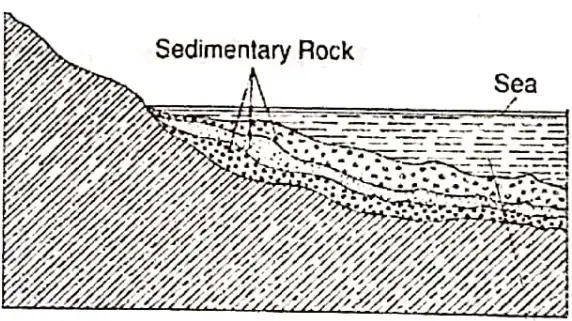
Saline Water Lake: Lake Maracaibo of northwest Venezuela is a saline water lake open to the sea. It is a shallow lake and the thick layers of sedimentary rocks under it are rich in oil deposits. In the eastern region, there are also a few small lakes in Brazil, most of them are saline water lakes.
Chapter 10 South America Climate Of South America
There are great variations in the climate of South America. This continent is called as a ‘Continent of diversified climate’ due to the following causes:
- The continent is located on both sides of the Equator. The upper part of the continent is located in the northern hemisphere and the lower part is in the southern hemisphere. Hence, exactly opposite seasonal changes are found in the northern and southern hemispheres i.e. when summer exists in the north, winter prevails in the south.
- Due to the Equatorial location either side of the equator has uniformly hot and humid conditions throughout the year. There is a little difference in temperature betwen summer and winter. There is no dry season.
- The regions which are located away from the Equator to the north and south, there is greater contrast in temperature between summer and winter.
- The Brazilian coast gets higher rainfall than the interior.
- South of the Brazilian Plateau, the Pampas Lowlands are in the temperate zone, winters are cooler and summer are less hot. Rainfall is moderate with maximum summer.
- Further south, the plateau of Patagonia, east of the Andes gets a low rainfall. This is a rain shadow region of the Andes. This is a temperate desert.
- West of the Andes, the southern most region of Chile has marine or oceanic type of climate.
- The Andes mountains region has climatic conditions varying according to height above sea-level.
Factors Affecting The Climate Of South America: There are great contrasts in the climate of South America and this is controlled by the following factors:
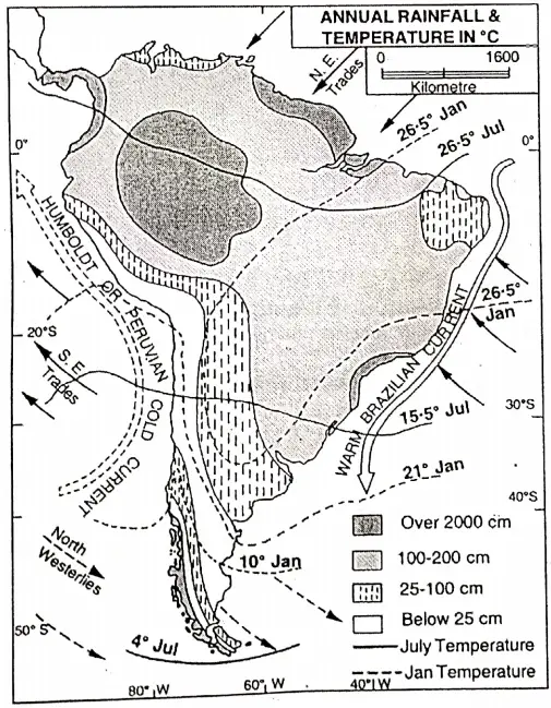
Latitudinal Extent: The important lines of latitude that cross the continent are the Equator (0°) in the north which passes through the Amazon estuary and the Tropic of Capricorn (232°S) which passes through the central part of the continent.
Thus the broad northern part of South America lies in the tropical zone and is hot throughout the year. While the narrow, southern part lies in the temperate zone has lower temperatures throughout the year.
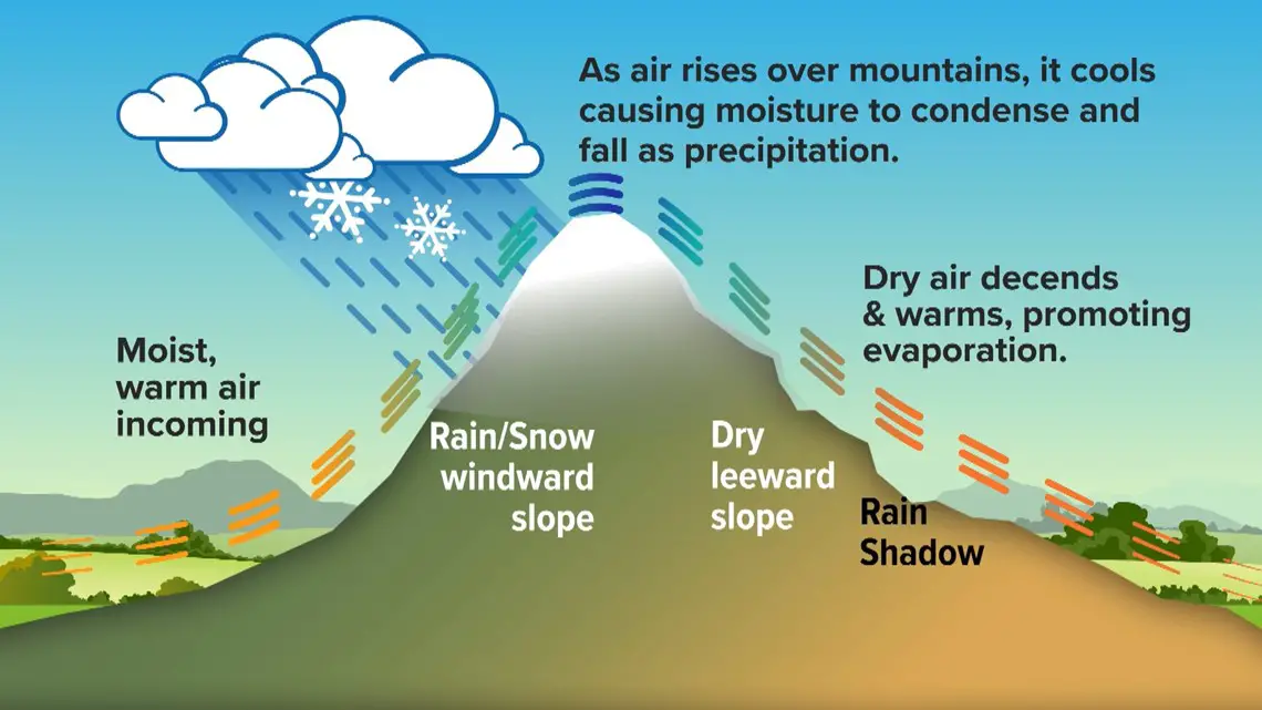
Altitudinal Factor: The mountain ranges especially the Andes influence the climate in two ways. Firstly, because of its high altitude, places situated on the mountains are colder than those on the plains lying on the same latitude.
For example, Quito situated on the Equator at a higher altitude has an average temperature of about 14°C while Manaus in the Amazon lowlands, also on the Equator, has an average temperature of about 26°C. Secondly, the Andes lies close to the Pacific coast and extend from north to south.
“WBBSE Class 8 Geography Chapter 10, South America important questions”
In the north, it stands as a barrier to the trade winds which blow in from the Atlantic, and in the south, it prevents the rain-bearing westerlies from crossing over to the east. As a result, most of the Pacific coast is dry but its southern part gets rain throughout the year from the westerlies.
The steel plateau edges of the Brazilian highlands force the trade winds to rise and this results in heavy rain in the Brazilian coast throughout the year.
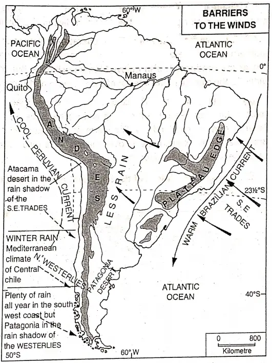
Prevailing Winds: The northeast and south-east trades blow toward the Equator in the tropical zone and cause rainfall in the eastern margin of the continent.
The Westerlies Rainfall: Role of the Andes blowing from the Pacific Ocean cause rainfall to the southwestern coast and Tierra-del Fuego. Central Chile gets rainfall in winter from the westerlies but remains dry in summer when it comes under the influence of the southeast trades.
Shape Of The Continent: Because of its unique shape, wider in the north and tapered in the south, major portion of the continent lies in the torrid zone.
Distance From The Sea: The moderating influence of the sea is felt in the tapered and Southern part of the continent where it is narrow. In the coastal areas of the broad northern part of the continent is also enjoy a Maritime climate. But the upper part of the continent is wider. So the climate in the interior of the northern part remains unaffected by seas and oceans.
Ocean Currents: The cold Humboldt or Peruvian current flowing along the western coast of Chile and Peru has a cooling and drying influence. So the south west coast of South America remains cool and dry.
The warm Brazilian current flowing along the eastern coast of Brazil warms the winds blowing over the sea. As a result the sea winds pick up moisture and cause heavy rain throughout the year.
Seasonal Conditions Of The Important Elements Of Climate In Different Parts Of South America:
Temperature: In the month of June-July, it is summer in the northern part of the continent where the sun is overhead. So the average temperature becomes 21°C which gradually decreases towards the south where it goes below 5°C (i.e. winter). But in the Andes and in the extreme South at Tierra del Fuego temperatures drop below the freezing point.
In December-January, when the sun is overhead south of the Equator, southern Brazil and northern Argentina being near the Tropic of Capricorn are the hottest parts of the continent with an average temperature of 30°C.
Temperature decreases to about 18°C further south and the extreme south the summer temperature is about 10°C. However, because of high altitude, the temperature varies from 0°C to 16°C. in the Andes ranges.
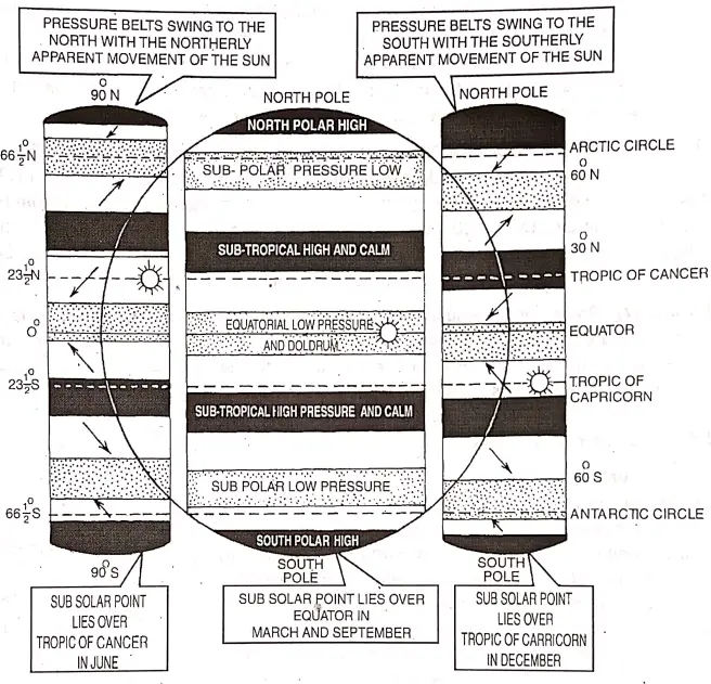
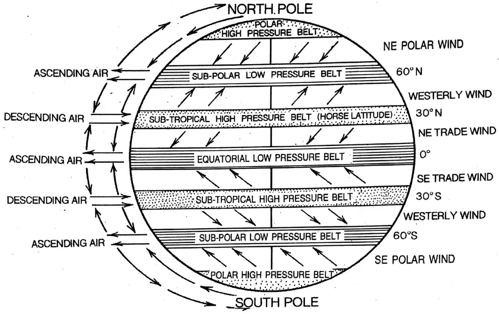
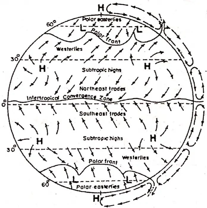
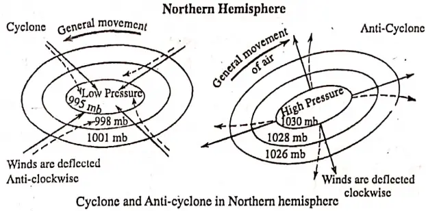
Air Pressure And Winds: Low pressure prevails, all the year, over the Equatorial region in northern part of the continent. So, the Trade Winds are blowing from the northeast and south-east of the equator to this Equatorial Low-Pressure Belt. North-west westerly wind blows throughout the year over the southern part of the continent.
Rainfall: The saying ‘rain follows the sun’ is true for South America. The Amazon basin over which the sun shines more or less directly throughout the year gets very heavy convectional rain throughout the year.
In summer, most northeast and south-east trade winds blowing from the Atlantic Ocean, being obstructed by the Andes give heavy rainfall of 200 cm. or more which decreases gradually from the Atlantic coast in the east to the Andes Mountains in the west.
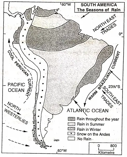
But the western side of the Andes becomes South America. The Seasons of Rain. dry as it is a ‘Rain Shadow’ area. So, it is found that the Atacama Desert is located in northern Chile bordering the Pacific Ocean coast.
Again the most northwest westerlies blowing from the Pacific Ocean give heavy rainfall to, the southern parts of the western coast as it is obstructed by the Andes mountains. Therefore, the Patagonia Desert is found in southern Argentina to the east of the Andes mountains where another Rain-shadow region has formed.
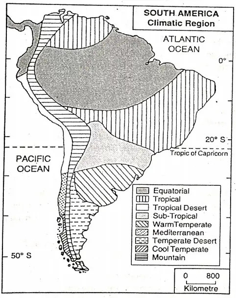
Climatic Regions Of South America: Based On The Variations In Temperature, Rainfall, Air pressure And Wind, South America May Be Divided Into The Following Climatic Regions.
- The Equatorial Climate;
- Tropical Savanna Climate;
- Hot Tropical Climate;
- Hot Tropical Desert Climate;
- Medi-terranean Climate;
- Temperate Desert Climate;
- Warm Temperate Climate;
- Cold Marine Climate and
- Mountain Climate.
Climate Region Of South America:
| Climatic Type/Region | Location | Climatic Characteristics |
| (1) The Equatorial Climate | Amazon and Orinoco basin near the Equator side by side in Brazil, Colombia, Venezuela, and southern Surinam. | (1)High Temperature (27’C) and humidity prevail throughout the year. Rainfall occurs about 200 cm/year.(2)Season change does not occur here (3)Convectional rain in the form of thunderstorms occurs more or less every day in the afternoon and there is no dry season at all. |
| (2) Tropical Savanna | Near the Orinoco river basin, and the Brazilian Highland, the grassland of Guinea. | (1)Summers are hot and Humid.(2)Winters are cool and dry.(3)Most of the rainfall occurs during summer. |
| (3) Hot Tropical Climate | Eastern Brazil | (1)Rainfall occurs In the summer.(2)Rainfall occurs due to moist trade winds from the east.(3)Summers are hot and humid.(4)Winters are cool and dry. |
| (4) Hot Tropical Desert | Atacama desert on the western part of the continent, Southern Peru, and northern Chile. | (1) The region is extremely hot and practically rainless. (2)Summers are very hot and winters are quite cold. (3)It is the world’s driest region. |
| (5) Mediterranean Climate | The southern part of the Atacama desert is located in Central Chile. | (1)Warm dry summers.(2)Mild wet winters. (3)Westerlies bring rain in winter. (4)The trades blowing over the land in summer fail to bring any moisture as well as rain. |
| (6)Temperate Desert | Desert regions of Patagonia in southern Argentina. | (1) Warm summer, (2) Cold winter,(3)Located in the rainshadow region of the Andes and receives only 13-15 cm. of rain annually. (4)It is called a temperate desert as it lies south of 40 latitudes. |
| (7)Warm Temperate (grass-land)Climate | South of the Tropical region In north-eastern Argentina and Uruguay | (1) Moderate climate. (2) Summers are quite hot. (3) Rainfall decreases and so does the temperature. |
| (8) Cold Marine climate | South Chile and coastal regions of south-east Brazil. | (1) Cool climate.(2) Heavy rainfall throughout the year.(3) Moist wind blowing from the Atlantic ocean. |
| (9) Mountain Climate | Mountain Climate prevails in the western part of the continent in the Andes mountain region. | (1) As the temperature decreases with increasing altitude, at higher altitudes cold climate prevails.(2) The top of the Andes mountain year. (3) In the foothills warm climate prevails. |
Chapter 10 South America Natural Vegetation of South America
As in other parts of the world, climate especially rainfall influences the natural vegetation of South America to a great extent. According to the variation in temperature and rainfall, natural vegetation of South America may be broadly divided into nine vegetation belts.
These are as follows:
Equatorial Rain Forest or Selva: The hot and humid climate has favored the growth of equatorial rain forests in the Amazon Basin and in the coastal regions of Guyana, Venezuela, Guiana, Surinam, etc. which receives heavy rain throughout the year. These forests are known as ‘Selvas’.
The Selvas of the Amazon Basin are the largest and densest expanse of equatorial forests in the world. The trees are hard evergreen and broad-leaved. The trees are 40/50 metres tall forming thick canopy through which sunlight cannot penetrate inside. So the ground is always damp and full of undergrowth.
Creepers are also common including the giant woody creepers called ‘lianas’ hanging from the branches. Thousands of species of trees are scattered all over the forest. As a result, it is difficult to obtain timber or forest products from the selvas. The trees are valuable hardwood varieties, such as Mahogany, Ablus, and Rubber. Brazil nut, Rosewood etc.
Tropical Grasslands or Savanna: This region lies north and south of the Equator. The Plateau of Brazil lying to the south of the Equator and a large part of the Orinoco river valley lying on the north are occupied by Tropical Grassland or Savannas.
Here rainfall is less and there is a distinct dry season that occurs only in summer and can support tall coarse grass and some trees many of which are acacias. These grasslands are locally called ‘Llanos’ in the Orinoco Basin and ‘Campos’ in the Brazillian Highlands.
“Class 8 Geography South America notes, WBBSE syllabus”
Warm Temperate Forests or GranChaco: This type of vegetation region lies south of the Brazilian Highland, i.e. the Parana-Paraguay river basin (the lowlands of northern Argentina and Western Paraguay). This region is locally called the ‘Gran-chaco’, which means ‘Great hunting ground’.
This region has open forests of sub-tropical valuable hardwood deciduous trees and grasslands. The chief trees of this region are the ‘Quebracho’ tree meaning ‘axe breaker’ is an extremely hardwood variety and the ‘Parana pines’, a type of softwood in great demand for building purposes.
The Quebracho, which yields tannic acid which is of great use in the leather industry. The leaves of the ‘Yerba Mate’ bush are brewed to make a tea-like drink.
Temperate Grassland Or Pampas: An extremely temperate grassland locally called ‘Pampas’ is found in Uruguay and around Buenos Aires in the northeast of Argentina. This grassland with soft, short, and juicy grasses is an ideal pasture for rearing cattle and sheep.
Characteristics of the Temperate Grassland or Pampas:
- The Pampas are vast grasslands.
- The grasses of this region are shorter than Savanna grassland.
- The grasses grow luxuriantly.
- These grasslands provide the basis for the pastoral industry.
- Parts of the grasslands have been cleared for cultivation.
Desert Vegetation: There are two types of deserts in South America-
- The thin strip of hot desert in coastal Peru and northern Chile called the Atacama desert and
- The temperate desert of Patagonia in southern Argentina. The desert of Patagonia in the southern0°Caribbean Seapart of South America is treeless with the scattered presence of the scrubs.
The Atacama desert is almost rainless, is practically 0° devoid of vegetation except for some cacti and prickly pear. Thorny bushes and scrub, however, grow in Patagonia.
Equatorial Rainforest or Selva Tropical Grasslands or Savanna Warm Temperate Forests or Granchaco Temperate Grasslands or Pampas Bushes Mountain Vegetation Mediterranean Vegetation Cool Temperate Forests Scanty Desert Vegetation.
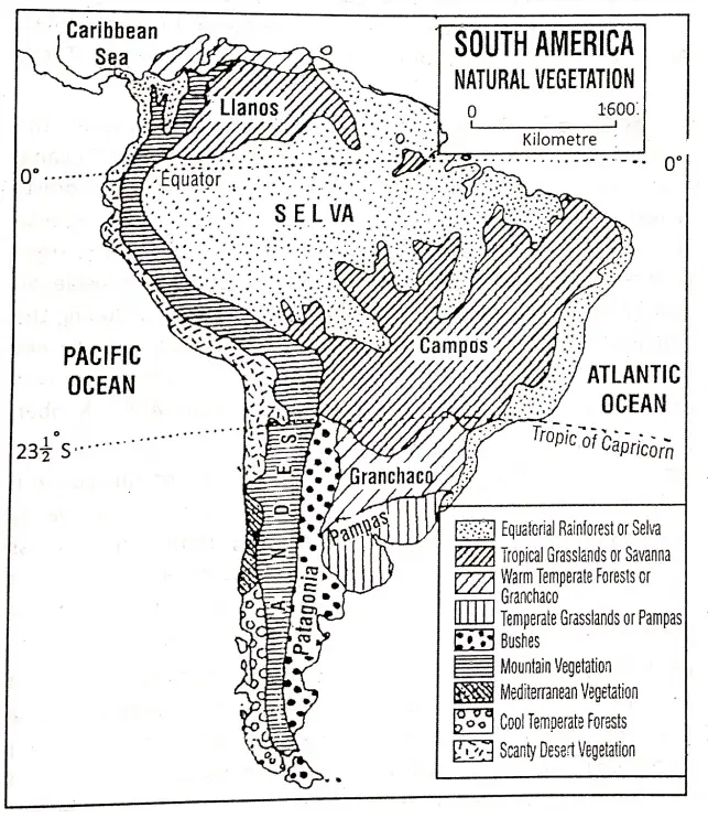
Mediterranean Vegetation: In central Chile with its humid or wet winters and warm dry summers, warm evergreen trees and shrubs occur. The Mediterranean climate supports dwarf vegetation which has long roots, small and thick waxy leaves, and short stems so that water is not lost through transpiration during the summer drought.
Common trees are fig, walnut, chestnut, and acacia. Evergreen Laurel, cork oak. grow in wetter areas, while lavender and rosemary grow in drier areas. Fruits like Olives and grapes also grow well in this region.
Cool Temperate Forests: Mixed forests of temperate deciduous and coniferous trees occur in southern Chile where rain falls throughout the year. Valuable hardwood trees like oak, beech, ash, and elm grow everywhere.
Softwood coniferous trees like pine and fir grow where snowfall is common, Some of the important trees of these forests yield valuable timber.
Mountain Forests: Owing to variations in altitude, the Andes mountains have a variety of natural vegetation. So in the western part of the continent, different types of trees are found.
Evergreen tropical rainforests and grasslands are common at the foothills. A little higher, there is the deciduous forest and then mixed forest which with increasing altitudes passes into the coniferous forests and finally into the Alpine meadows. Above the meadows occurs perpetual snow.
Little or No Vegetation: Atacama desert in northern Chile is treeless and dotted with thorny shrubs and bushes.
Chapter 10 South America The Selvas Evergreen Forest:
The Selvas of the Amazon basin are the largest and densest expanse of evergreen equatorial rainforests in the world. The forest lies on both sides of the equator covering mainly the major portion of the Amazon basin.
It covers Brazil (60%), Peru (13%), Colombia (10%), and parts of Venezuela, Bolivia, Guyana, Surinam, and French Guiana. It covers an area of about 5.5 million square kilometers.
The hot and humid climate has favored the growth of the equatorial rainforest in the Amazon basin which receives heavy rain throughout the year. The annual average temperature varies from 25° 28°C and the annual average rainfall is about 250 300 cm. A few places rainfall exceeds 1000 cm.
Thus the trees are hard, evergreen, and broad-leaved. This region is, therefore, called as “The Equatorial Evergreen Rain Forest’. Though it is a region of bright sunshine the region abounds in dense, lush green and luxuriant vegetation throughout the year. As the trees have grown closely spaced trees form a common canopy or crown.
No wonder the sunrays are often fail to peep through the thick foliage of trees in these forests to reach the ground. It is the trees that have to view with one another to reach out to the sun, and hence they grow very tall (some trees are 40 – 45 meters). So, the region is known as the “Region of twilight”.
Over a small area hundreds of different species of trees grow side by side. Therefore, the trees do not occur in pure stands. These forests are known for valuable hardwoods like mahogany, ebony, rubber, rosewood, ironwood, green heart, ivory wood, Brazil nut, and balsa (a very light wood).
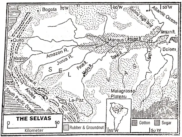
The trees are of different heights. The branches of the taller trees are so thickly intertwined that sunlight cannot pass through the roof or canopy of leaves and branches. Creepers climb up the trees weaving a maze as it were and there is a dense undergrowth. Thousands of species of trees are scattered all over the forest.
As a result, it is difficult to obtain timber or forest products from the Selvas. Apart from the oceans, these forests are our largest source of atmospheric oxygen. It supplies about 20% of the earth’s oxygen and is termed the “lungs of the world”.
These evergreen forests are known for beautiful birds and butterflies. They occur in all sizes and in bright colors of every hue. The region overflows with insects and worms too. There are numerous termites, mosquitoes, spiders, ticks, driver ants, and tsetse flies.
Among the tree animals, there are monkeys, known for their wits and acrobatics. Apes, the closest cousins of human beings, are also found here. Puma and Jaguar of the Amazon valley are tiger-like animals that dwell upon trees. They mostly hunt monkeys for their food. Sloths, flying foxes, (bats), tree lizards, tree frogs, and flying squirrels are the other tree dwellers.
The Anaconda is the longest python that dwells here. It girdles its prey suffocating it to death. The forest rivers are full of a wide variety of fishes along with crocodiles and turtles. In the rivers, there are also found alligators and carnivorous Piranha fish.
Ten percent of the world’s total leaving species is found here. 25 lakh insects and four lakh species of trees exist here.
This region is very thinly populated because the weather is unhealthy. The density of the population in the Amazon basin is about two (2) persons/square kilometer. Primitive economic activity still prevails in a large part of the Amazon basin.
There are some groups of people still living deep inside the jungle. Though there is an amazing variety of valuable trees in the Selvas, lumbering is not well developed.
This is mainly because-
- Thousands of species of trees are scattered all over the forest. So the same type of trees is hardly found close together. As a result, it is difficult to obtain timber/lumber from the selvas.
- Most of the trees are very hard and difficult to saw.
- After sawing, it is difficult to bring down the tree since the upper boughs of other trees are interlaced, and lianas twine round them.
- The trunk is too heavy to be dragged upto the river over the soft forest floor. In the presence of these difficulties, lumbering is not developed in the Selva region.
Chapter 10 South America The Pampas Region
The grassland of Pampas in Argentina represents one of the great wheatlands and battlefield of the world. This is the most prosperous region of Argentina. The word ‘Pampas’ is derived from the spanish word ‘Pampa’ which means ‘extensive open plain land’.
An extensive grassland surrounding Buenos Aires in a semi-circle or like a crescent moon, to the northeast of Argentina, is called the ‘Pampas’.
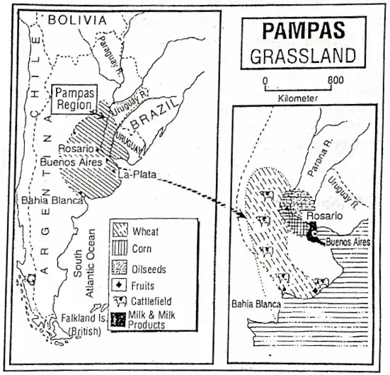
Location: The region lies in the La-Plata basin. This region occupies one-fourth of Argentina and most of Uruguay and it also includes a small part of southern Brazil. It extends from 30°S to 40°S latitudes and 54° west to 65° west longitude between the Andes and the Atlantic.
Boundary The Pampas region is bounded on the north by uninhabited Gran Chaco, on the south by the Patagonia desert, on the west by the foothills of the eastern slopes of the Andes, and on the east by the Atlantic.
Physiography: The Pampas is a flat lowland sloping gently towards the Atlantic. It is formed by the silts, sands, clay, and loess soils deposited by the river and wind. Silts are very much fertile and in some places more than 150 meters thick.
There are a few hills because of which the plain appears to be rolling. There are two hills -Sierra del Tandil and De la Ventana (1300 m) in the Province of Buenos Aires. These are actually, the extended parts of the Brazilian Highlands. The region is higher in the western margin (about 450 m.) and it is only 20 meters in the east.
Rivers: The important rivers of the region are Uruguay (1593 km) and the Parana (4880 km). They have joined with each other near the north of Argentina’s capital Buenos Airesas La-plata estuary to fall into the Atlantic Ocean. The tributary of the Parana in this region is the Salado.
“WBBSE Class 8 Chapter 10 Geography, South America solutions”
Two other rivers are Colorado and Negro in the south. Following the slope, they all flow into the Atlantic. The Paraguay river is also a tributary of the Parana river.
Climate: The climate of this region is warm temperate type. Due to the close proximity with the ocean, the climate is comfortable here. The average summer temperature (In January) varies between 20°C to 26°C and in winter (In July) temperature varies between 8°C to 12°C. Annual rainfall varies between 50-100 cm. The rainfall increases from west to east.
Frost is common in winter. In summer, a strong cold wind called the ‘Pampero’ blows one the Pampas from the southwest. This is often welcomed since it not only towers the temperature but also causes rain that refreshes the pastures.
Natural Vegetation: The Pampas is a Typical temperate grassland supporting hardly any tree. The grass, though shorter than the Savanna grass, is softer and juicier. As the rainfall is more in the eastern part of the region the grasses are tall.
The original Pampa grass is now being replaced by other European grasses like Alfalfa. A few trees like Eucalyptus grow on the hills of the east-central part of this region. A few trees are also found mainly along the rivers. At present, most of the grassland has been destroyed for agricultural purposes.
Irrigation: Due to the insufficient river flows over the Pampas, irrigation is needed. So, wells are dug and wind pumps are used to tap underground water for irrigating the agricultural lands.
Agriculture: The western part of the Pampas is a semi-desert. This region called the dry Pampas is thus mostly barren, but the humid Pampas in the east is the chief source of the agricultural wealth of Argentina. It is one of the richest livestock cum crop-producing land of the world. Pampas region is famous for wheat cultivation.
- Mild cool climate,
- Rainfall,
- Rolling plains,
- Fertile soils favour the cultivation of wheat.
Here Wheat is the leading crop. 60% is exported to other countries. So the Pampas is known as the “Wheat basket of South America”. Maize, flax, cotton, linseed, barley, sugarcane, oats, and soybean are also cultivated. Fruits (apricots, apples, cherries, pears, and peaches) and vegetables are grown especially around the big cities.
Other fodder crops cultivated are rye and other oilseeds. Different types of agricultural products are grown here in abundance. So the Pampas region is called “The Granary of South America”.
Animal Rearing: The Pampas region is the grazing ground for Argentina’s famous cattle. Sheep are also reared here. Cattle are raised on the tall grasses in the east and sheep are raised in the west and southern parts of drier and cool climates. A rench where 20000 cattle and sheep are raised, is locally called ‘Estancia’ each of which covers 4000 acres of land.
They are raised for meat, hides, wool, milk, and milk products (Powdered milk, butter, cheese, cream etc.) which are expected in large quantities to the foreign countries Argentinas beef is prized throughout the world for its superior quality and flavor, Argentina is the largest exporter of beef in the world.
Beef extract, and ground bones are also produced here. Buenos Aires, La Plata is noted for animal products cordoba located on the foothills of the Andes is a famous dairy center. Dairy farming is also practiced around large cities meet the huge daily demands for dairy products in the local markets.
Merino sheep are reared in the drier south and southwest and the English breeds elsewhere. Thus large amounts of mutton and wool are exported to Europe.
Mineral resource: The Pampas region is not rich in mineral resources. Little copper ore and tungsten are available on the hills in the north. A little quantity of gold is also available on the bank of the river Salado.
Transportation: The lowlands of the pampas are well served by a network of roads and railway lines. There is also a transcontinental railway line from Buenos Aires to Valparaiso in chile passing through the Andes mountains. Export-import.
Industry: The pampas region is poor in mineral resources. As a result, no large-scale and metallurgical industries have been developed here. Industrial development has taken place based on agricultural and animal raw materials.
Important industrial activities are-
- Dairy farming,
- Meatpacking,
- Leather,
- Wool and other consumer goods, manufacturing.Important industrial centers are Buenos Aires, Laplata, Cordoba, and Rosario other industrial activities of these centers,
- Engineering,
- Chemical,
- Cotton textile,
- Food processing,
- Oil refinery etc.
Population: Pampas Region is not well populated. The vast grasslands are usually used as pastures and farmlands. Gauchos, the cowboys who are engaged to look after the cattle, are actually pastoral nomads. But the cities are well-populated, Such as,
- Buenas Aires,
- Bahia Blanca,
- La-Plata,
- Rosario and
- Cordoba.
“WBBSE Geography Class 8 South America, Chapter 10 key concepts”
Buenos Aires: This is the capital, principal city, and chief port of Argentina. This is a million city (12.05 million in 2001), and the second largest city of South America. It is situated at the estuary of La Plata and an important industrial as well as trading center of Argentina. This is known as the ‘Paris of South America’.
Bahia Blanca: It is situated on the Atlantic Coast and chief seaport of Argentina.
La-Plate: La Plata is a modern city cum industrial center.
Rosario: It is situated on the Parana, a natural link between the Gran Chaco and the Pampas. It is a rail and road hub and on important river port cum industrial center.
Cordobadairy center: Cordoba is also a fast-growing industrial cum tourist center and famous dairy center.
WBBSE Notes For 8 Class Middle School Geography
- Chapter 1 Interior Of The Earth Notes
- Chapter 2 Unstable Earth Notes
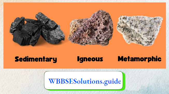
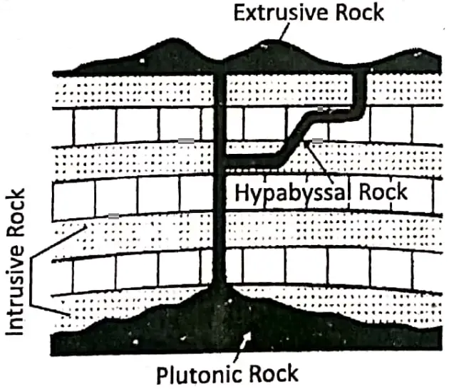
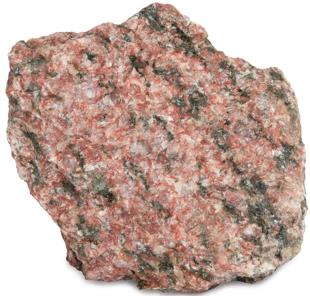
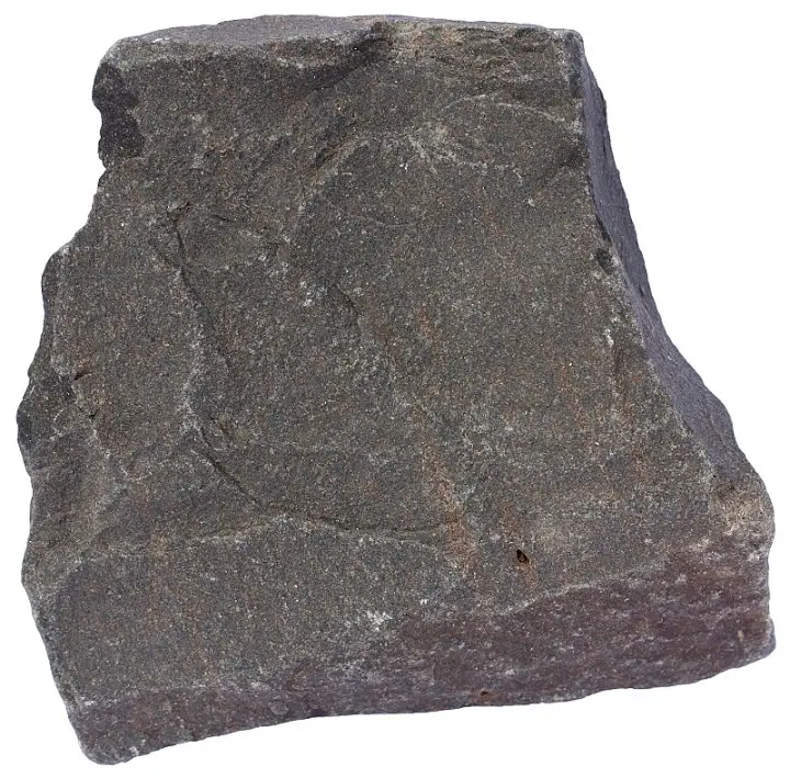
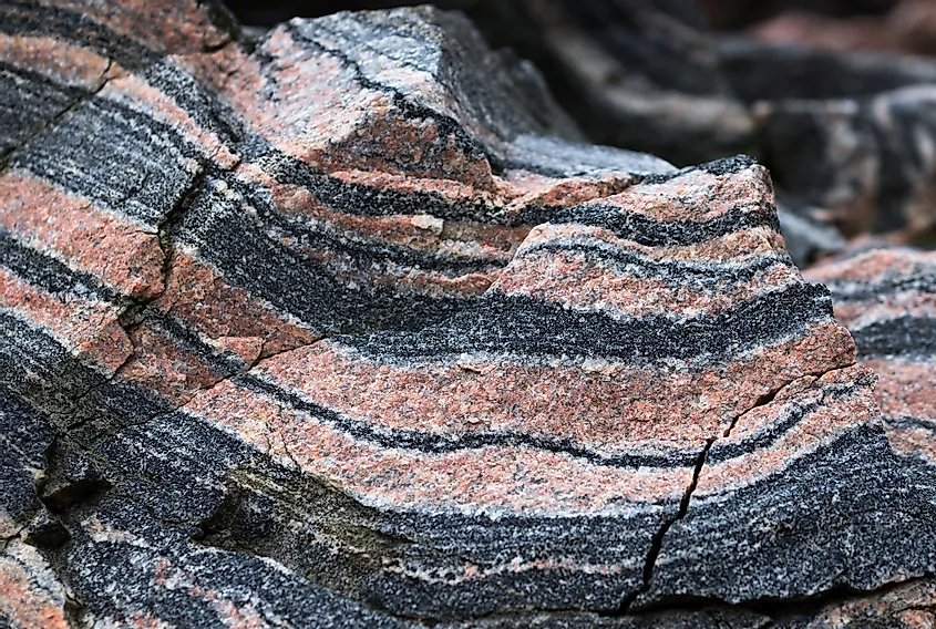
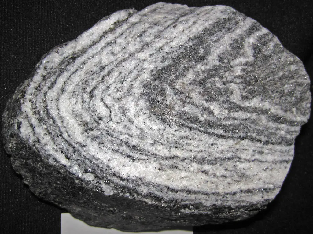
- Chapter 3 Rocks Notes
- Chapter 4 Pressure Belts And Winds Notes
- Chapter 5 Cloud And Rain Notes
- Chapter 6 Climatic Regions Notes
- Chapter 7 Human Activities And Environmental Degradation Notes
- Chapter 8 Some Neighbouring Countries Of India Notes
- Chapter 9 North America Notes
- Chapter 11 Oceania Notes