
Chapter 9 North America
Introduction Of North America :
North America is the third largest continent of the world, after Asia and Africa. A few centuries ago, this continent was almost unknown. But now it has made great materialistic progress and it is the principal centre of modern civilization and has achieved world supremacy in almost every sphere, such as economy, education, science and technology, politics, and industrial development.
“WBBSE Class 8 Geography Chapter 9 notes, North America”
Discovery/Expedition of North America:
About 5 centuries ago the Europeans had the hobby to discover the unknown or new lands of the world and they started expeditions in different parts of the world. The great Italian Navigator, Christopher Columbus discovered the Eastern Islands of North America (Islands of West Indies) in the year 1492 A.D.
Read and Learn all WBBSE Notes For 8 Class Middle School Geography
He sailed westward from Spain, believing that the earth being round, he would reach India by sailing towards the west. Nobody knew that there was a big continent of North America in the mid-ocean.
Columbus, in fact, landed on the islands now named as ‘West Indies’ It was he who termed the red-skinned people of these islands as ‘Indians’ thinking that he had reached India. In 1497 A.D., another Italian, Amerigo VespuccActually touched the mainland of North America. The continent derives its name from him.
| Class 8 General Science | Class 8 Maths |
| Class 8 History | Class 8 Science LAQs |
| Class 8 Geography | Class 8 Science SAQs |
| Class 8 Maths | Class 8 Geography |
| Class 8 History MCQs | Class 8 History |
“Class 8 WBBSE Geography Chapter 9 notes, North America study material”
North America became separated from South America by constructing the Panama canal and navigation become easy between the Eastern coast of North America and Europe and the Western coast of South America Panama Isthmus narrow strip of landmass (a width of just eighty km) lying between North America and South America and joins two continents is called Panama Isthmus or Isthmus of Panama.
Class 8 Geography Chapter 9
Since 1914 A canal has been dug through the Isthmus of Panama, connecting the Atlantic and the Pacific Oceans is called the ‘Panama Canal’. Why North America is called the ‘New world’ The continent was unknown to the Europeans and others for a long period.
Therefore, when the continent of North America was discovered by the Europeans, they called it as ‘New World’.
Location of North America:
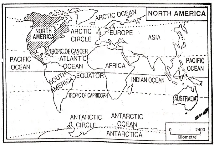
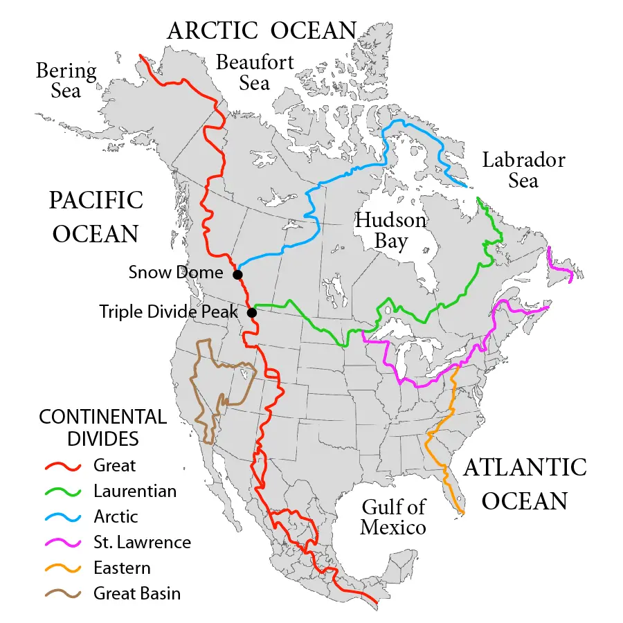
North America lies entirely within the Northern and Western hemispheres. It stretches from 7°12′ North (south of Panama) to 83°07′ North latitudes (North of Greenland) and from 52°37’W to 172°27′ West longitudes. It extends for 8480 km from North to South and for 6400 km from West to East. 100°W meridian bisecting the continent longitudinally.
Boundaries of North America:
North America Is bounded on the north by the Arctic Ocean, on the south by the Panama Canal and the Pacific Ocean, and where it is linked with South America by a narrow land bridge—the Isthmus of Panama. On the east it is bounded by the Atlantic Ocean, and on the west by the Pacific ocean.
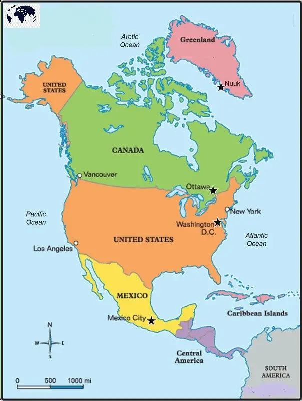
To the northwest, the continent is separated from Asia by the Beiring strait which is only 58 km wide and to the south, the continent is separated from South America by the Panama canal. North America includes a few islands, such as-
- Greenland (the largest island of the world) in the north,
- New Foundland in the east,
- Cuba and Jamaica in the east and
- Hawaiian islands in the west.
“WBBSE Class 8 Geography Chapter 9, North America study guide”
Area: North America covers an area of 2,44,00000 square kilometers and ranks third in size (next to Asia and Africa) amongst the continents of the world.
Population: The population of this continent is about 465,000,000.
Geographical Importance of North America: North America is the most dynamic and powerful continent in the world. This significant importance of the continent has been achieved mainly due to several geographical factors.
These are as follows:
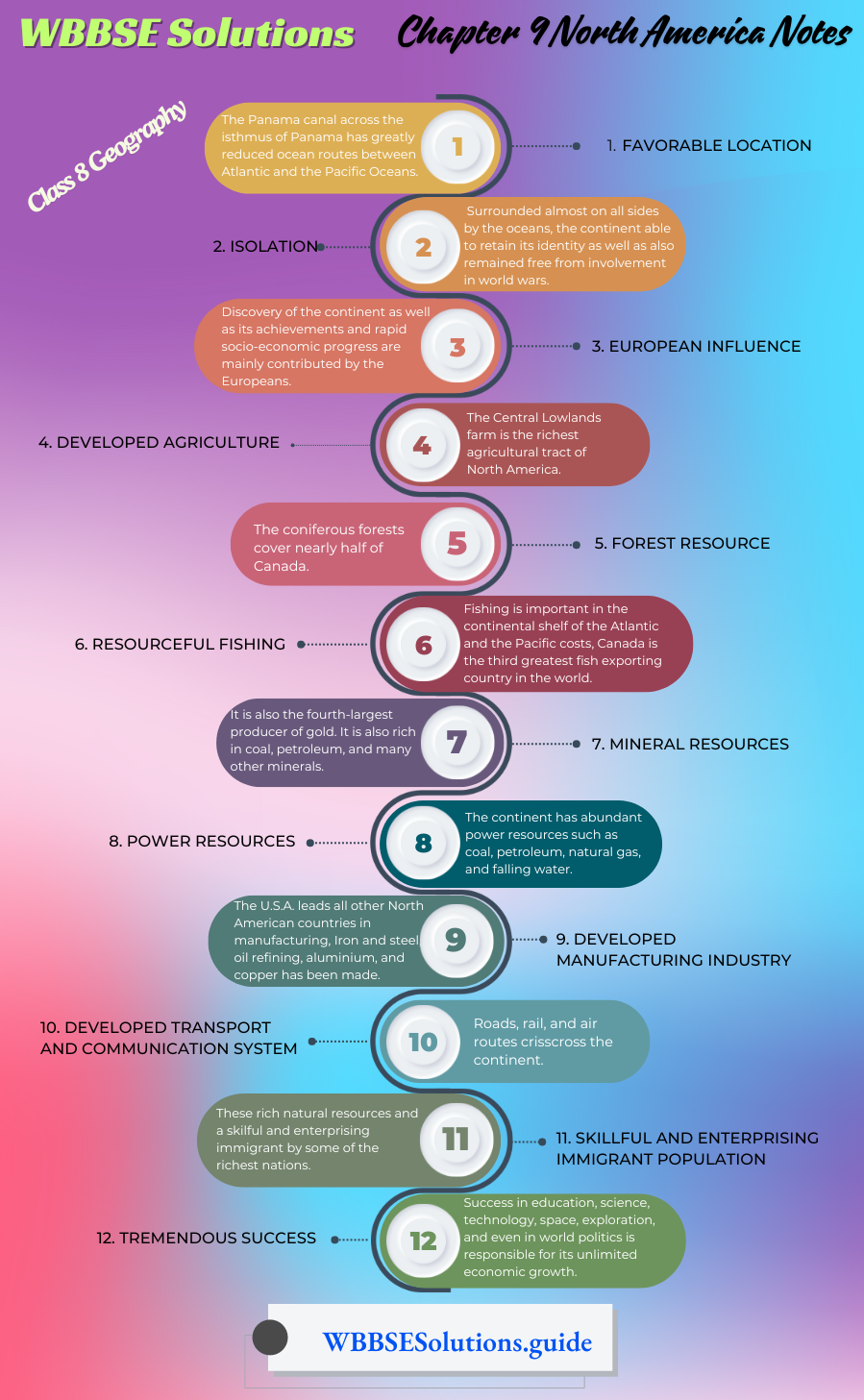
- Favorable Location: Though this continent is not centrally located like, Europe, North America is placed favourably for trade with Europe across the Atlantic and with Japan and South-East Asia across the Pacific. The Panama canal across the isthmus of Panama has greatly reduced ocean routes between the Atlantic and the Pacific Oceans.
- Isolation: Surrounded almost on all sides by the oceans, the continent has been able to retain its identity as well as also remained free from involvement in world wars.
- European Influence: Discovery of the continent as well as its achievements and rapid socio-economic progress are mainly contributed by the Europeans.
- Developed Agriculture: North America has excellent farmlands. The Central Lowlands farm is the richest agricultural tract of North America. The Canadian Prairies are one of the greatest wheat-producing regions of the world. Corn, cotton, and tobacco are grown more to the south in the U.S.A. In central California, fruit growing is very important.
- Forest Resource: The coniferous forests cover nearly half of Canada. Canada is the world’s greatest producer and exporter of newsprint and is second to the U.S.A. in wood pulp production. These forests are also the home of fur-bearing animals.
- Resourceful fishing: Fishing is important in the continental shelf of the Atlantic and the Pacific costs, Canada is the third greatest fish exporting country in the world.
- Mineral resources: North America is extremely rich in minerals and it leads the world in the production of iron ore, copper, lead, zinc, molybdenum, vanadium (U.S.A), silver (Mexico), and nickel (Canada and Cuba). It is also the fourth-largest producer of gold. It is also rich in coal, petroleum, and many other minerals.
- Power Resources: The continent has abundant power resources such as coal, petroleum, natural gas, and falling water. The U.S.A. has almost one-third of the world’s coal reserves, 25% of the world’s Petroleum, and more than 25% of the world’s water power reserves while Canada has 14%. North America has also, rich of uranium which is the basis of nuclear fuels.
- Developed Manufacturing Industry: The U.S.A. leads all other North American countries in manufacturing, Iron and steel, oil refining, aluminium, and copper has been made. Automobiles and machinery, meat packing, and food processing.
- Developed transport and communication system: Roads, rail, and air routes crisscross the continent. The U. S. A. has about 25% of the world’s railroad mileage and about 38,400 km. of navigable waterways.
- Skillful and enterprising immigrant population: These rich natural resources and a skilful and enterprising immigrant population have made North America the richest continent inhabited by some of the richest nations.
- Tremendous Success: Success in education, science, technology, space, exploration, and even in world politics is responsible for its unlimited economic growth. In fact, the continent has become the focus of world political and economic power.
Chapter 9 North America: Physical Features of North America
Relief of North America: Landform of the continent of North America is very much diversified. Physiographically, the continent can be divided into five divisions—
- Western Mountains or Cordilleras,
- The Eastern Highlands,
- The Canadian Shield in the North,
- The Central Plains and
- The Coastal Plains.
The Western Mountains or Cordilleras (Spanish ‘cordillera’ means rope or chain): Western part of North America is covered by the fold mountains that stretches from Alaska in the northwest to the Isthmus of Panama in the south about 6900 Km.
It extends along the Pacific Ocean coast, as such, it is also Pacific Mountains. It is the widest (about 1700 km) at the central part- where its altitude is not very high. But it is narrow in the north and in the south where the height of the mountain is relatively higher.
North-South extended three parallel mountain ranges have formed a cordillera:
- To the extreme east, lies the longest, highest, and almost continuous range of the Rockies. They begin as the Brooks Range in Alaska and continue as the Mackenzie Mountains Selkirle Range, Rocky Mountains, and the Eastern Serra Modre. The northern part of Rocky mountain is. called ‘Endicott’ while the southern part is called ‘The Sierra Madre’.
- To the west of Rocky, there is another range which is known as the ‘Alaska Range’ in the extreme north in Alaska, the coast mountains and the Cascade Range in Canada, Sierra Nevada Range in California, and the Western and Sn Sierra Madre in the extreme stuff in Mexico. Mt Mckinley (6194 m), an active volcano on the Alaska Range is the highest peak of the continent while Mt. Logan (5951 m.) in Canada is the Second highest. Mt. Whitney is the highest peak (4420 m) of the Sierra Nevada
- In the extreme west of the continent along the Pacific coast lies the third mountain range which is called St. Elias in the north in Alaska and as Coast Range in Canada —U.S.A.
“WBBSE Class 8 North America notes, Geography Chapter 9”
Plateaus of Western Mountains: In between the parallel ranges are located intermontane plateaus, such as
- Yukon plateau between Endicott and Alaska range,
- Columbian plateau located to the south-west of the Yukon plateau,
- Idaho or snake plateau in the western part of the U.S.A.,
- Great Basin to the south of it.
- Colorado Plateau between Rocky mountain in the east and Sierra Nevada in the west and
- Mexican Plateau further South in Mexico,
- In the extreme south lies the plateau of Central America.
Valleys of Western Mountains: The Western Mountain Range consists of many broad river valleys. These are as follows:
- Colorado Valley: The Colorado river flows through the world famous ‘Grand Canyon’ which is 446 km long, with 1600 m. depth in some places, and is the largest canyon of the world.
- The Valley of California: The valley is located in between the Sierra Nevada and Coast Range.
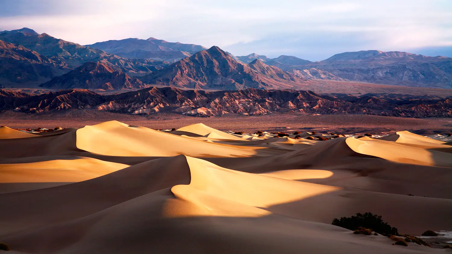
- Death Valley: The famous Death Valley’ is located to the southeastern part of Sierra Nevada. It is the lowest part of the continent (83 m deep below sea level). This region is the lowest-lying area, of the Western hemisphere and the hottest region (56°C) of North America. Due to the high temperature and salinity of stored water, no animal can live here. So this valley h is known as “Death Valley”.
Class 8 Geography Chapter 9
Important Passes: The important passes through the Rockies are the Yellow Head, Kicking Horse, and Crow’s Nest passes in Canada and the Yellowstone Pass in the U.S.A.
Volcanoes Western Mountains: There are many volcanoes, such as—Orizaba or Citlaltepetl (5610 m.) Popocatepetl (5465 m.) and Colima (3883 m). They are highly active volcanoes.
The Eastern Highlands: In the east of North America, the Eastern Highlands extend from Labrador in the north to Alabama in the south. It includes Greenland also.
These are much older, lower, and less rugged than the mountains of the Western Cordilleras. Their average elevation is not more than 1400 metres. These are made up of ancient crystalline igneous and metamorphic rocks, such as granite, gneiss, schist, slate, and quartzite.
“Class 8 WBBSE Geography Chapter 9, North America easy explanation”
These highlands run southwards from Newfoundland roughly parallel to the east coast. Their continuity is broken by the St. Lawrence Valley and the Hudson-Mohawk Gap. So, it consists of three isolated units—
- Labrador Plateau in the north,
- New England High Lands in the middle and
- Appalachian Mountain along the Atlantic coast.
North-south extended Appalachian Mountain, also known as Atlantic Mountain’ it is an old fold mountain. Due to age-long denudation, it has been lowered than the Rocky mountain. Its western escarpment is called ‘Allegheny’.
Further west, lies the Cumberland Plateau. Eastern Section is called ‘Blue Ridge’. Mt. Michel (2038 m) of Blue Ridge is the highest peak of the Appalachian mountain.
The easternmost part of the Appalachians is called the ‘piedmont Plateau’. This plateau descends to the plain quite steeply and the east-flowing rivers form rapids and waterfalls as they tumble over the edge of the plateau, called the ‘fall line’.
These falls are used for generating hydel power. Blue Ridge and Piedmont plateau were formed in the Caledonian system about 50—40 crores years ago. Allegheny was formed in the Carboniferous period about 32 to 22 crores years ago.
“WBBSE Class 8 Geography Chapter 9 notes, North America PDF”
The Canadian Shield in the North: The Canadian Shield is the oldest part of North America. Surrounding Hudson Bay in the north lies the Canadian Shield which is also known as the ‘Laurentian shield’. It is made up of extremely ancient igneous and metamorphic rocks mostly granite and gneiss.
Slow sinking and erosion have lowered this area to nearly a plain or a peneplain (200—500 m) which is interrupted by the presence of occasional low hills (35—65m) such as Mesabi. During the Ice Age, the Canadian shield was severely scoured by ice. As a result the land was smoothened and numerous lakes were formed.
The Central Plains: The Central plains lie between the Rocky Mountains in the west and the Appalachian Mountain in the east from where the plains stop towards the centre of the continent. These plains made up 60% of the total area of the continent.
They form a great belt of horizontally bedded sedimentary rocks. The plan is also made up of eroded ancient rock in the north where lies the Great Lake Region comprising five lakes. In the south, it is made up of young alluvial soil.
- To the northeast lies.
- St. Lawrence River valley.
- To the west is the Great Lake region,
- Further west lies the Prairies and
- To the south is the Mississippi river valley.
These plains are by no means low everywhere. They rise westwards until they are over 500 metres in the High Plains that lie among the foothills of the Rockies.
The Coastal Plains: There are also some coastal plains along the long coastline of the continent. The Arctic coastal plain in the north is much wide but remains ice-capped. Pacific coast. The Atlantic coastal plain extends up to the ‘fall line’.It is wider than the Pacific Plain. The wide coastal plain of the Gulf of Mexico extends northwards and merges with the Central plains.
Chapter 9 North America: Rivers Of North America
Many rivers are flowing through this continent making a network of rivers. These rivers are characterised by the following important features.
- The Rocky Mountain in the west and the Appalachian Mountain in the east of the continent act as a ‘water divide’ from which many rivers have originated.
- There are many long rivers, such as Mississippi-Missouri and there are also some short rivers, such as west-flowing rivers.
- The rivers flowing to the east of the Eastern Highlands towards the Atlantic Ocean are short but the rivers flowing west of the Eastern Highlands are long. Again, the rivers flowing east of the Western Mountains are long but the rivers flowing west of the Western Mountains are short.
- The rivers which are drained into the oceans are short but turbulent.
- The rivers which flow towards the interior are long but their velocities are less.
- There are some rivers which flow along a few lakes, i.e. St. Lawrence.
- Most of the rivers of this continent are perennial.
- There are a few inland rivers in this continent.
- There are some rivers that form waterfalls and are suitable to generate hydel power.
- Some navigable rivers are flowing in different parts of this continent which help to develop irrigation systems, transportation, and industrial and commercial progress.
Important Rivers of North America:
| Types of the Rivers | Name of the Rivers |
| 1. East-flowing rivers or rivers drained into the Atlantic Ocean. | 1. Lt. Lawrence, Hudson, Delaware, Mohawk, Potomac, etc. |
| 2. South-flowing rivers or rivers drained into the Gulf of Mexico. | 2. Mississippi-Missouri, Rio-Grande or Rio-Bravo, Alabama, etc. |
| 3. West-flowing rivers or rivers drained into the Pacific Ocean. | 3. Columbia, Snake, Yukon, Sacramento, San Joaquin, Colorado, Fraser, etc. |
| 4. North-flowing rivers or rivers drained into the Arctic Ocean and Hudson Bay. | 4. Mackenzie, Nelson, Churchill, Chesterfield, Great Whale, Albany, etc. |
| 5. Inland Rivers. | 5. Saskatchewan, etc. |
Based on variations in source, the direction of flow, the volume of water, and their mouth, rivers of North America can be grouped into the following five categories:
East flowing rivers or the rivers draining into the Atlantic Ocean:
- St. Lawrence: St. Lawrence is the longest (4000 km) and principal river of this region. It rises in the highland west of lake Superior as the St. Louis river in Minnesota and flows through Superior, Michigan, Huron, Erie, and Ontario to drain into the Atlantic Ocean. It has formed the famous ‘Niagara Falls, 51 m high, between Erie and Ontario Lakes. The river is of great economic importance as it has connected the Great Lake Region with the Atlantic Ocean.
- The Hudson: The Hudson (507 km) rises from the Adirondack mountains and flows south through a low narrow gap in the Appalachians. It meets the sea through the city of Newyork.
- Delaware: The Delaware river (454 km) is originating from the Appalachian mountain flows southeastward and drains into the Atlantic ocean. The famous Philadelphia city is situated on the mouth of this river.
- Mohawk(240 km): Mohawk is the largest tributary of the Hudson river It is formed by the junction of east and west branches in Oneida, and flows south and east into the Hudson river at Cohoes, above Troy.
- The Potomac (465 km): This river is about 465 km long and originates from the Appalachian Mountain flows along the boundary between West Virginia and Maryland and empties into the Chesapeake Bay of the Atlantic Ocean. The capital of the U.S.A., Washington D, C. is situated on this river bank.
“WBBSE Class 8 Geography Chapter 9, North America important questions”
South flowing rivers or the rivers drained into the Gulf of Mexico:
- Mississippi-Missouri: The Mississippi (3770 km) entirely a river of the U.S.A., is the longest as well as the largest river of North America. It rises in the highland, west of lake Superior, flows southward and drains into the Gulf of Mexico. Its principal tributary, Missouri meets the Mississippi about 16 km north of St. Louis. The combined flow of Mississippi and Missouri is the third longest (6210 km) river of the world. Other important tributaries of Mississippi areÿea0 Ohio, Arkansas and Tennessee.
- Missouri: Missouri (3726 km), the greatest tributary of the Mississippi, originating from the Rocky Mountain in the West flows south-eastward and joins the Mississippi river. The famous ‘Great Falls’ has formed by the Missouri river. Missouri is a turbulent and muddy river. The river not only supplies huge quantities of water but also a large load of silt to the Mississippi. Yellowstone river, a tributary to Missouri, has formed many springs and geysers at Yellowstone, national park. There is the famous ‘Old Faithful Geyser’ from which hot water is ejected to a height of 60 metres at an interval of 90 minutes.
- The Rio-Grande or Rio-Bravo: The Rio-Grande (3060 km), one of the longest rivers of North America, is a snow-fed stream. It rises from the Southern Rocky Mountains in southwestern Colorado and flows to the Gulf of Mexico marking the entire border between the U.S.A. and Mexico.
- Alabama: This navigable river is about 510 km. It flows south-west ward and drained into the Gulf of Mexico.
“Class 8 Geography North America notes, WBBSE syllabus”
West flowing rivers or the rivers drained into the Pacific Ocean: These rivers rise in the Western Mountain and flow westward to drain into the. Pacific Ocean. They are short in length but turbulent and have formed deep gorges.
- The Columbia (1967 km): The Columbia rises from the Selkirk Range- in British Columbia and flows through Canada for about 800 km and the U.S.A. for about 1200 km, it enters the Pacific Ocean at Astoria. There are many dams on this river of which the grand Coulee’ is the largest.
- The Snake (1682 Km): The Snake is the largest tributary of the Columbia. In its lower course, the river passes through a gorge called the hells Canyon’. A maximum depth of 2400 metres makes it the deepest gorge of North America.
- The Yukon(3190 km): The Yukon, the longest river of Alaska, rises from the Coast Range and flows first northwards and then westwards to enter the Bering Sea through Alaska. A major part of this river freezes in winter.
- The Sacramento (615 km): The Sacramento is a south-flowing river which occupies the longitudinal valley of California. The river Sacramento and San Joaquin flowing from opposite directions join each other before entering the Bay of San Fransisco.
- The San Joaquin (567 km): The San Joaquin river also occupies the longitudinal valley of California. It flows west and north-westward and before entering the Bay of SanFransisco it joins with the Sacramento river.
- The Colorado (2349 Km): The Colorado river rises in the Rocky Mountains of Colorado in the U.S.A. and for 27 km marks the international border between the U.S.A. and Mexico. It drains a largely arid and semi-arid region of the West U.S.A. and Mexico. Finally, it enters the Gulf of California in Mexico. The river along with its tributaries has formed a labyrinth of narrow Canyons which are more than 1500 metres deep. The longest of these Canyons through which the main river flows is the spectacular ‘Grand Canyon’.|t is 446 km long and in places, more than 1600 metres deep. It ranges in width from 200 metres to 29 km.
- The Fraser (1377 km): The Fraser is the chief river of British Columbia. It flows between the Rocky and Caribou ranges and meets the sea south of Vancouver. It is famous for salmon fisheries and is an important shipping route.
“WBBSE Class 8 Chapter 9 Geography, North America solutions”
North flowing rivers or the rivers drained into the Arctic Ocean and Hudson Bay:
- The Mackenzie (1650 km): The Mackenzie is an important river of Canada that flows out of the Great Slave Lake, and after draining northward through the western part of Canada, falls into the Beaufort Sea of the Arctic Ocean. A major part of the lower course of the river remains snowbound from October to June. If the Peace river which enters the Great Slave is considered a part of the Mackenzie, the total length of the river will be 4241 km.
- The Nelson (648 km): The Nelson river flows out of the North Lake of Winnipeg through several lakes of North-East and falls into the Hudson Bay at Port Nelson.
- The Churchill: This river is about 1600 km long and rises in Lake la Loche in northwest Saskatchewan, flows eastward across Saskatchewan and northern Manitoba and turns northeast into Hudson Bay at Churchill.
- The Chesterfield: This is an inlet, of Hudson Bay. It rises from the north of the central plain of North America flows towards the north and falls into Hudson Bay.
- The Great Whale: This is a river of central and western Canada. It is about 373 km long. It flows westward and enters the southeast of Hudson Bay.
- The Albany: This is a river of north-central Ontario of Canada. It is 988 km long and rises in the chain of lakes (largest St. Joseph) in West Ontario and flows east and northeastward into West James Bay at Fort Albany. In winter the water of this river is frozen.
“WBBSE Geography Class 8 North America, Chapter 9 key concepts”
Inland Rivers of North America:
There are a few inland rivers, the course of which are restricted within the continent. River Saskatchewan an inland river.
The Saskatchewan(1939 km):
The Saskatchewan river is an inland river that rises in the eastern slope of the Canadian Rocky Mountains. The meaning of the word ‘Saskatchewan’ is the ‘rapid river’. It flows eastward for 550 km to enter Lake Winnipeg. The river is widely used for the generation of hydel power and irrigation.
Lakes of North America:
There are many lakes in different places of North America. Though most of the lakes are located in the northern part of the central plains, a few lakes are found in the mountain land also. So, the lakes of North America are of two types according to their location.
These are as follows:
- Lakes of the Plainland: In the northern part of the central plains are located five famous lakes Superior, Michigan, Huron, Erie, and Ontario. These are freshwater lakes. Lake Superior is the largest lake in North America and the second largest lake of the world (The Caspian sea is the largest), as well as the largest freshwater lake of the world. These five lakes are interconnected through the St. Lawrence river and have formed the ‘Great Lakes’ Many freshwater lakes are also found in Canada, such as Winnipeg, Great Bear, Great Slave, Athabasca, Reindeer etc.
- Lakes of Mountainland: In the western mountains there are saltwater lakes. Such as the Great Salt Lake and the Lake Nicaragua. Among the saltwater lakes of North America the ‘Great Salt Lake’ is the largest.
Chapter 9 North America: Climate of North America
North America has a great variety of climates. The climate of North America is very much, diversified and controlled largely by the following factors:
- Latitudinal Extent: North America mainly extends from the tropical latitudes (in the South) to the frigid zone (Arctic region in the north) and thus, in general, temperature decreases from south to north.
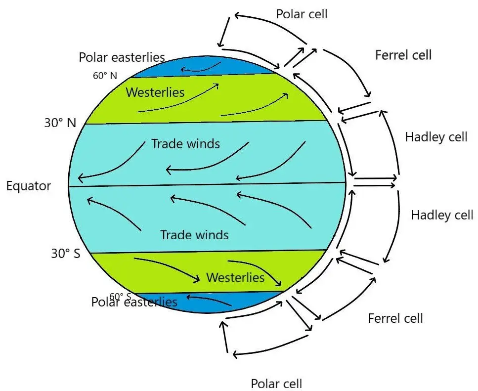
- Alignment of the mountains: The north-south trend of the Western Cordilleras and the Appalachians cannot obstruct the winds blowing from the north and south. So the very cold polar winds enter the continent in winter and this results in frozen water surfaces even as far south as New Orleans.Similarly, the absence of any barrier permits warm winds to enter the land from the south throughout the year. In winter these winds make the temperature moderate by rising it, and in summer create ‘hot waves in the interior parts of the southern U.S.A.On the other hand, the Western Cordilleras act as an effective barrier to the warm westerlies. These rain-bearing winds blowing in from the Pacific drop much of their moisture on the Western slopes of the mountains. So the eastern slope remains nearly dry and in places have deserted.
- Distance from the Sea: By virtue of its vast size and extent, the interior part of the continent is far from the sea, as such extreme condition prevails in the interior of the continent. Nearly the whole of the northern part of the continent freezes in winter but becomes quite hot in summer.
- Ocean current: Ocean currents also have a great influence on the climate of North America. The California current in the southwest and the Labrador current in the northeast are cold currents. They produce a cooling effect on the adjoining coastal areas. In the southeast, the Gulf stream and in the northwest, the Alaskan current are warm currents. As a result, the climate of the coastal areas becomes warmer.
- Altitude: The effect of altitude on climate is experienced in the Western Cordilleras that remain snow-covered in winter.
- Wind: The westerlies bring heavy rain to the west coast throughout the year while the Trade winds bring heavy rains to the southwest coast.
Due to the above factors the climate of North America is full of diversity.
“WBBSE Class 8 Geography Chapter 9, North America summary”
Seasonal conditions of the important elements of climate in different parts of North America:
Temperature: In summer, (May to October) temperature decreases from the southeast (maximum 32°C) to the north,(below freezing point). In Winter, (November to April) due to the presence of cold polar wind, the temperature even in the southern part of the continent remains low (16°—20°C)
Air Pressure and Wind: In summer, low pressure develops in the southern part of the continent due to high temperatures. Therefore, moist monsoon wind blows over this region. In winter, high pressure develops over the northern parts of the continent due to severe cold. Therefore, the cold Polar wind blows here.
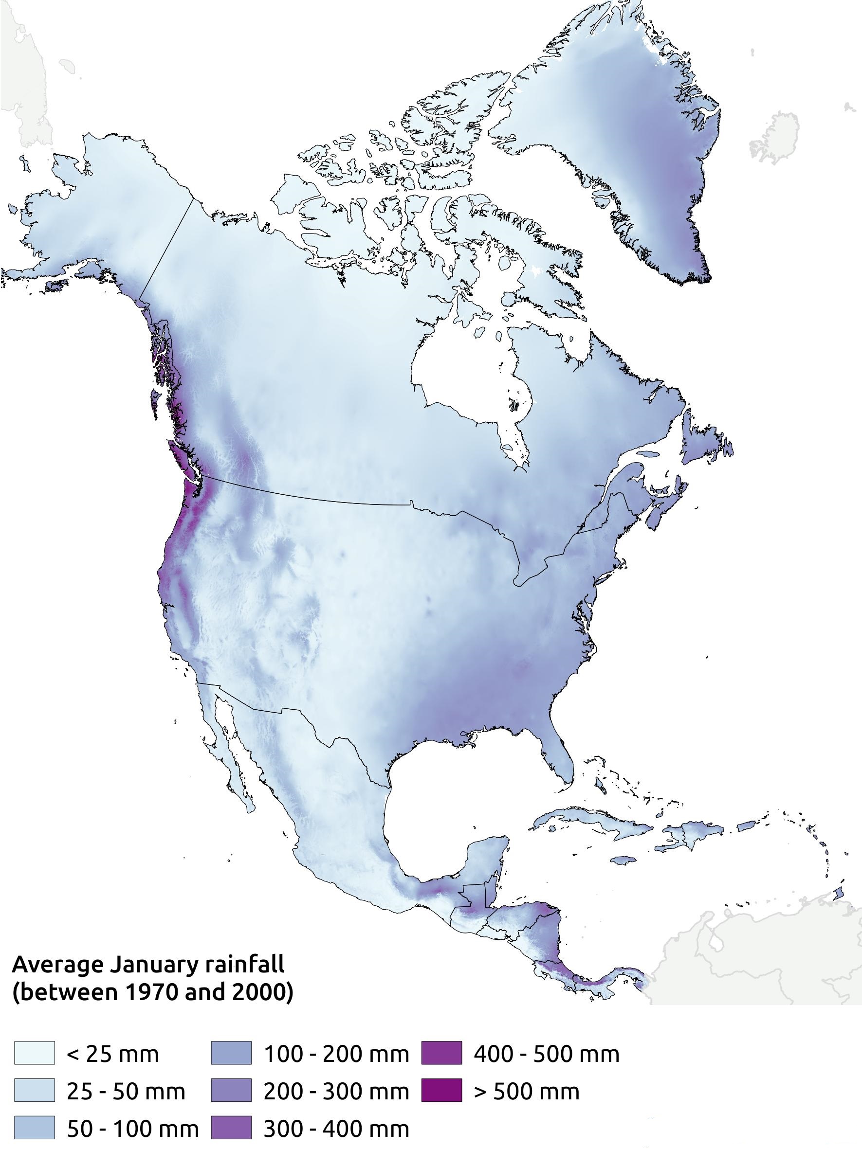
Rainfall: Heavy rainfall (100-200 cm annually) occurs in the northwest coast; the south-eastern and central part of the continent. Moderate rainfall (50 to 100 cm, annually) in the southern part of the west coast and in the central plains of the continent. The least rainfall (less than 25 cm annually) occurs in the southwestern part of the continent where a number of hot deserts have formed.
Class 8 Geography Chapter 9
Climatic Regions of North America: Based on variations in temperature, rainfall,air pressure, and wind, the continent of North America can be divided into ten c ima c r These are as follows:
- Arctic (very cold) or Tundra Climatic region.
- Cold Temperate Interior or Taiga Climatic region.
- Cold Temperate Eastern Margin or Laurention climatic region.
- Cold Temperate Western Margin climatic region.
- Cool Temperate continental type of climatic region.
- Temperate Desert climatic region.
- Hot Desert climatic region.
- Warm temperate East Margin or China type of climatic region.
- The Mediterranean climatic region, and
- Tropical Hot and Humid climatic region.
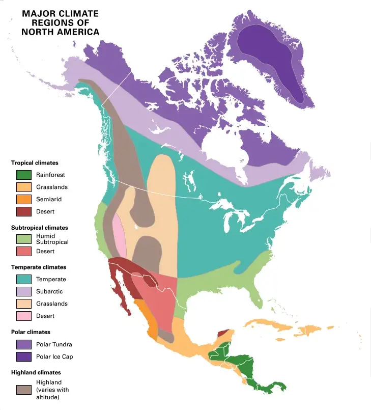
| Climatic Type | Location | Characteristics |
| Arctic (Very cold) Tundra Region | Northern parts of North America, Alaska in the west Labrador in the east, and in Greenland. | (1)Winters exists for 8-9 months throughout the year (2)Snowfall and Blizzards are common in winter (3)Rainfall occurs due to temperate cyclone only in summer. |
| Cold Temperate Interior (Taiga) | From British Columbia of Canada towards the south of Thunder region to Newfoundland. | (1)Summer is short, (2)Heavy snowfall in winter and (3)Scarcity of rainfall is the main characteristic of this climate. |
| Cold Temperate Eastern Margin | The north-eastern part of the continent. | Moderate rain, (100-150 cm.) longer cold winters, and mild Summer occurs throughout the year. Temperate Cyclone occurs seldom. |
| Cold Temperate Western Margin | North-west coast of the continent. | Summers are pleasant and winters are mild. Heavy rainfall (100 – 200 cm.) occurs throughout the year. The sky remains cloudy. |
| Cool Temperate Continental climate | The central part of the continent, the Rocky Mountains, and the middle part of the Great lakes. | Though summer is very hot, winter temperature is often below freezing point. So the climate is extreme. Another name of this climate is the Prairie climate. |
| Temperate Desert climate | Eastern slopes of the Western Mountains of North America. | (1)It is a rain shadow area. (2)Rainfall is low. (3)Winters are severely cold. |
| Hot Desert climate | Sonorom desert, California is west to Mexico in the east. | Due to scanty rainfall deserts are formed in a vast areas. Summer is long, hot, and dry. |
| Warm Temperate | Mississippi plains, East coast region, Lake Region to entire eastern highlands. | The summer climate is hot. Rainfall occurs throughout the year due to S. W. Westelies Coastal region being cool in winter. |
| Mediterranean type of climate | California, a coastal region in the southwest part of the continent. | (1)Rainfall occurs in Winter due to S.W. Westerlies, (2)Summer is dry, (3)Moderate comfortable climate and sunny weather are found throughout the year. |
| Tropical hot and Humid type of climate | The southern part of Florida and the West Indies, are countries of middle America. | (1)Climate is hot and humid. (2)Rainfall occurs throughout the year like equatorial region. (3)Sometimes tropical cyclones (Hurricanes) occur here. |
Chapter 9 North America: Natural Vegetation Of North America
Natural vegetation belts are always closely related to the different types of climate. As North America has a variety of climates, so it has a great variety of natural vegetation. The natural vegetation of North America can be divided into the following types.
- The Tundra Vegetation: The extreme north of the continent is known as the Tundra or the cola desert region. This region lies along the northern coast of Canada from Alaska to Labrador. It is very cold and remains frozen throughout the year.That is why this region is known as “permafrost” or permanently frozen subsoil. Here the winters are long and cold and summers are short. The snow melts during the short summer. Its vegetation includes mosses, lichens, grasses, dwarf bushes, and arctic flowers. Reindeer, polar bears, musk-ox and caribou, etc. are the chief animals of this region.
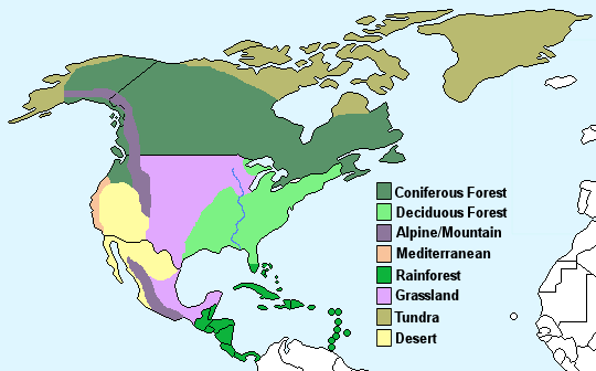
- The Taiga or the Coniferous Forest Belt: To the South of the Tundra lies a wide belt of coniferous forests known as the ‘Taiga’. This wide belt runs from the Atlantic to the Pacific across Canada. Here the winters are severe and the summers are warm, coniferous forests are widespread and provide softwood as such the forest is also called ‘softwood forest’.Pine, Far, Spruce, and Larch are important trees and these are well adapted to the climate of this region. The trees have tough, narrow needle-shaped leaves, dark green in color. Fur-bearing animals such as boar, silver fox, beaver, mink, lynx, etc. are the common animals of this forest.
- Temperate Mixed Forest Belt: The temperate mixed coniferous and broad-leaved Deciduous Forest region lies to the southeast of the Taiga (coniferous forest). The region extending from Lake Region in the north to the Eastern High land is occupied by deciduous trees like oak, maple, elm, ash, beach, and Douglas fir.The trees are mainly of the hardwood type and broad-leaved varieties. In autumn the .leaves become reel, yellow or orange color and the trees shed their leaves, as such Autumn is called here as ‘Fall’. Among the coniferous trees are include pine, fir, and cedar trees. They yield softwood. Much of the original forests have been cleared for the growth of the dense settlement. Crops are grown in those areas.
- The Tropical Rain Forest: The main areas of Tropical Rain Forest are along the Gulf coast of the U.S.A and Florida. West Indies and the southern coast of Mexico are hot(26C) and get more than 150 cm of rain. So dense evergreen forests of hardwood trees cover these regions. The natural vegetation includes pa|mS/mahogany, logwood, the famous yellow pine, and cypress. Lowlands and slopes of this region have been cultivated intensively and various crops such as graphs, sugar cane, and rice are produced. Large tracts of land near the coast have been opened up for banana plantations.
- Temperate or Midland Grassland: Temperate grassland is the vegetation of the great centra I plains. These regions have very light rainfall, too low for proper growth of trees; so only tall grass grows. The natural vegetation of this region consists of almost treeless grasslands, called ‘Prairies’. Central part of the continent between the Rocky mountain in the west and the Great Lake Region in the east is occupied by this vast grassland of temperate latitudes in the interior of North America. This region is now cultivated and forms a vast wheatland. In other parts. Barley is grown. Cattle farming is the main occupation of the people of this region.
- The Mediterranean Vegetation: This type of vegetation is found on the West Coast of California. Here summers are hot (25°C) and dry, while winters are wet and cool (10°C). This type of vegetation is drought-resistant evergreen trees and shrubs. These are specially adapted to face the hot and dry summer. The trees have small, glassy, waxy leaves which prevent transpiration and long tap-roots which reach deep underground. They have also bulky trunks and thick bark to store moisture and to withstand the dry summers. Some of the main trees which grow in this region are olive, cork-oak, laurel, and Mediterranean pine. Other trees include figs, citrus, and vine. Fruits like grapes, oranges peaches, apricots, and lemons are also cultivated in this region.
- Warm Temperate Vegetation (The Sub-Tropical Hardwood Forests): These types of forests are found in the southeastern U.S.A. Here summers are hot (above 27 C), winters are cool (7°C to 13°C) and rainfall varies from 100 to 150 cm. The important trees include the long-leafed yellow pine and palms. The ‘Everglades’ or the swampy areas of Florida have mangrove trees. Here the trees have stilted roots to keep them above the level of the saline seawater.
- The Mountain Vegetation: This type of vegetation is found mainly in the western and eastern mountainous regions of the continent of North America. The effect of altitude on climate is experienced in the Western Cordillera and Eastern Highlands that remain snow-covered in winter. Due to the decrease of temperature, the characteristics of vegetation is changed As such in the high altitudinal region there is coniferous trees are available.
- The Vegetation of Hot Deserts: The Desert region lies on the plateaus enclosed between the main eastern and western ranges of the cordilleras in North Mexico and Arizona in the U.S.A. Because of the poor rainfall (below 25 cm) hardly any vegetation grows in these deserts. Cactus is the main vegetation, Prickly pear Joshua trees survive with the aid of dew in places where there is slight rainfall. Scanty grass, sage bush, and thorny scrubs also grow in hot deserts.
Chapter 9 North America: Prairie Grassland
An extensive treeless level grassland of North America is called ‘prairie’. French ‘prairie’ meaning a tract of meadows, occupies a great triangle in the heart of the continent. The prairies are the mid-latitude temperate grasslands of the central United States and Canada and extend from Alberta, Saskatchewan, and Manitoba in Canada, southwards through the Dakotas, to Kansas, Oklahoma, and Texas. The Prairie grasslands have the following distinguishing features.
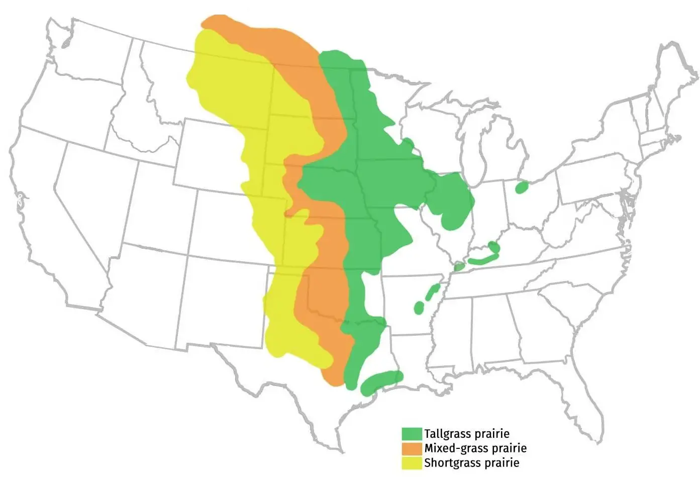
- These lie in the interior of the continent.
- These are environmentally very important and represent a distinct kind of biome.
- These are remote from maritime influence.
- The heartlands of these grasslands are practically treeless.
- The grasslands have distinctive wet and dry seasons. Droughts are common and frequent.
The climate of this region is ideal for grass to grow. Here the temperature ranges between 15°C and 25°C. In winter temperatures may go much below freezing points as in Winnipeg in Canada. There is summer rainfall.
The rainfall varies between 20 cm to about 70 cm and the average rainfall is about 50 cm/per year the winters are fairly dry, with just a little snow in the north. Large areas of the Prairies have been plowed for cereal production, and the wetter eastern parts are very productive. The drier western prairies, where the grass is shorter, are less productive.
These grasslands lie in the zone of Westerlies. Since then lie in the interior, the westerlies lose the moisture content by the time they reach this region. Therefore the amount of rainfall is low. The wind velocity is high in the grasslands because there are no trees to obstruct them.
Local winds are also important.
“WBBSE Class 8 Geography Chapter 9 North America, definitions and examples”
The climatic conditions ensure fairly regular growth of grass with variations due to the change of seasons. The rainy season makes the dormant grasses sprout with tender shoots. These are nutritious and realized by animals.
When the dry season approaches, the grasses start bearing a brownish look and by the autumn season, they are completely dried. Grasses now become dormant and are better able to face the drought on the one hand and the frost and snow on the other.
The higher western part called the high Plains’ has less than 50 cm of annual rainfall. This supports short grasses and is noted for livestock farming. The High Plains form the short grass prairies while the eastern part receives above 50 cm of rain forms the long grass prairies. These have now been converted into wheat lands. Hay, clover, and Alfalfa grasses are grown here.
So this grassland is famous for grazing grounds. For reason, dairy farming is developed here. For the conservation of dairy products modern refrigeration systems have been built here. It is one of the world’s very fertile plains. Therefore, besides the rearing of animals, the raising of crops like wheat, barley, oats, etc. have become highly important in these areas.
The hot local winds of chinook ascend from the Pacific coasts and then ascend to the Prairies; it melts snow and raises winter temperature. This condition makes even agriculture possible in the winter months of this region.
This is suitable, for wheat production. So this region as spring wheat belt’. The leading wheat-growing states in the U.S.A. are North and South Dakota, Minnesota, Montana, Iowa, and Wisconsin. In the southern part of the spring wheat belt wheat cultivation is practiced in winter. As in different seasons wheat is cultivated sufficiently in this region it is called the “Breadbasket of the World”.
Chapter 9 North America: The Lake Region Of North America
Introduction: The Lake region is one of the most important and prosperous regions of the e US.A. well as North America. A little to the north-east of the continent of North America, near the borders between the U.S.A. and Canada, there are a wonderful series of great five lakes—
- Superior,
- Michigan,
- Huron,
- Eric and
- Ontario.
‘Great Lakes’ and along the southern shores of the ‘Great Lakes’ lies the country s greatest industrial district—the Lake Regions of the U.S.A.
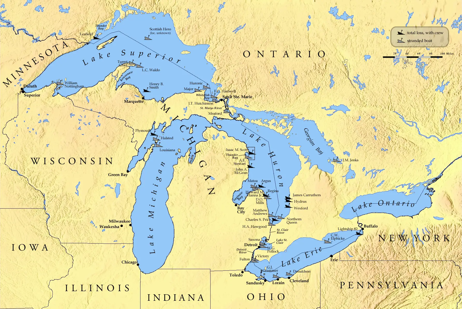
Class 8 Geography Chapter 9
Location: The Lake Region of the U.S.A. is located in the Eastern part of North erica. This region extends between 41°N and 50° N latitude, and between 75°W and 93°W longitude.
The Lake Region of the U.S.A. comprises of the greater parts of the eight states of the U.S.A. t at one adjacent to the lakes. The eight states of U.S.A. that extend around the lakes are—
- Minnesota,
- Wisconsin,
- Illinois,
- Indiana,
- Michigan,
- Ohio,
- Pennsylvania and
- Newyork
Area: Lake Region of the U.S.A. covers an area of nearly 7 lahks 64 thousand square Kilometres. The area of the total water bodies of these lakes is 2 lakh 50 thousand Square kilometers. West to east extension – 1370 km and North to South extension – 1125 km.
Physiographic Characteristics: The Lake region of the U.S.A. is extensively flat land. It belongs to the central plains of North America. At some places it is an undulating plain (average height less than 180 meters), because of glacial depositions of stones and pebbles. There is a steep escarpment (75 m) between Erie and Ontario lakes. World famous Niagara Falls (51 m) has been originated in between the Erie and Ontario lakes.
Rivers: Principal river of this region is the St. Lawrence. It flows eastwards through the lakes and finally drains into the Gulf of St. Lawrence. The river is known as St. Marie between Lake Superior and Huron, St. Claire between Huron and Eric, the Niagara between Erie and Ontario Lakes, and St. Lawrence Seaway between Lake Ontario and Montreal.
Origin of the Lakes: The region is the most valuable gift of the ice Age to North America. In Ice Age North-eastern part of the USA is actually a lowland that was covered by Ice sheets. When this ice melted, waters of all these lakes were drained either to the Hudson Bay through Mohawk or to the Gulf of Mexico through Mississippi rivers, because then St. Lawrence was still frozen.
After the melting of the ice of St. Lawrence, the waters of these five lakes started to drain through the St. Lawrence river into the Atlantic ocean. Due to prolonged erosion, these vast snow-covered regions have been transformed into basins.
“WBBSE Class 8 Geography North America, revision notes”
Gradually this basin has been fulfilled with melting water and transformed into the great lakes. There are five lakes on the course of the St. Lawrence river. These are—superior (largest, 82500 Sq. km) Huron, Michigan, Eric, Ontario and they are popularly called ‘Five Great Lake’.
Climate: The climate of the Lake Region is a cool temperate type. Pleasant summer temperature varies between 17°C and 23°C severe cold. Winter temperature varies between – 3°C and – 13°C, as cold winds from the north blow in. As a result, rivers and lakes become ice-bound. Extensive snowfall covers the whole region in winter. Rainfall occurs mostly in summer and it varies annually between 75 cm and 80 cm.
Natural Vegetation: The natural vegetation consists of hardwood deciduous trees like maple, oak, ash, and hickory mainly found in the south. Coniferous trees like pine, spruce, and birch are also found in the north of this region. Most of the forests have been cleared to make way for mixed farming, industrial development, and dense settlement.
Soils: The region is mostly covered by fertile glacial soil. Grey-brown-podsolic soil which is moderately fertile also covers some parts. Fertile black soil or chernozem occupies most of the Lake Region of the USA. In this region infertile soils are also found which are mixed with stones, rocks, etc.
Chapter 9 North America: Economic Environment Of The Lake Region
Agriculture: The Lake Region of the U.S.A. is well-developed in agriculture because of its
- Flat land,
- Adequate rainfall,
- Fertile soils,
- The modern and scientific method of cultivation.
Large quantities of wheat, corn, barley, oat, oilseed, and beet are produced. Hay, and clover, are also grown as fodder crops in this region. This region is also ideal for mixed farming.
The cultivation of this region is practiced mainly by ‘crop rotation’ (Instead of producing a particular crop again and again, different crops are cultivated by rotation).
Grape, apple, and peach are also produced in this region. Central highland is famous for the highest maize-producing region of the world. So the Lake Region leads first position in the world for maize production.
Livestock Ranching: In the northern part of this region different grasses, like Hay, Clover, Alfalfa, etc. are cultivated for cattle feeding. So this region is developed in dairy farming and known as the ‘dairy belt’ of the U.S.A.
Sheep and pigs are also raised here. Wisconsin is famous for its daring and is known as the ‘Dairy state’. Chicago is famous for its meat production and is known as the ‘largest slaughter House of the world”.
The reasons for the development of livestock farming in this region are as follows:
- Hay, clover, and Alfalfa grasses are grown here sufficiently which supply food for cattle.
- A sufficient supply of water from the lakes.
- The extensive plainland of this region is favorable for grazing.
- The cool temperate climate of this region helps to preserve the milk, meats, and different dairy products.
Mineral Resources: The Lake Region of the U.S.A. is enriched with mineral resources. Varieties of minerals in large quantities are produced here, such as
- Iron ore (About 75% of the U.S.A.) comes from the areas south and west of lake Superior—Mesabi (the largest Iron ore mine of the USA). Vermillion, Gogebic, Marquette and
- Menominee.
- Copper ore—Cuyuna,
- Coal—Illinois and Indiana,
- Petroleum—Illinois and Michigan,
- Rock Salt—Ohio and Michigan.Other minerals include
- Limestone,
- Gypsum,
- Zinc,
- Lead and
- Manganese
Transportation System: The transport system is very developed in the Lake Region. Other than railways, roads,s and airways are also specially developed. The economic development of the Lake Region is mainly due to the cheap transport through St. Lawrence.
The Niagara falls area is not navigable but there is a separate canal constructed around this. Eg. the Weyland canal allows ships to travel freely.
It is also noted that Chicago is one of the busiest airports in the world and is also the largest railway junction in the U.S.A. The Great Lakes and the St. Lawrence river together constitute one of the greatest inland waterways of the world.
Industry: The Lake Region of the U.S.A. is not only the leading industrial belt of North America but this is the most developed industrial region of the whole world. This Lake Region has become the greatest Industrial Region of the world with the help of the following causes:
- Local Iron-ore: Large quantities of rich iron ore obtained from the Lake Superior mines Vermillion, Mesabi, Marquet, Menominee, etc. via the Great Lakes, and from Labrador via, St. Lawrence Seaway.
- Nearby Appalachian coal: The vast coalfields of Pennsylvania, West Virginia Eastern, and Western Interiors are all nearby and provide fuel.
- Developed Transportation System: The Great Lakes St. Lawrence waterways, the Eric canal that connects the finance capital cum port of New York via the Hudson river, the noise canals that join the Mississippi system, and a dense network of rail and roadways provide excellent transport.
- Raw Materials: Large quantities of iron ore, limestone, manganese, lead, zinc, and gypsum are also mined locally. Petroleum is supplied from the oil fields of Pennsylvania, West Virginia, Michigan, and Illinois. Corn, meat, hides, dairy products, and timber from softwoods provide raw materials for industries based on agriculture.
- Sufficient Hydroelectric Power: Sufficient hydroelectric power is gained from the strong current river and Niagra falls.
- Dense population: The high density of the population provides plenty of skilled labor and a vast market for industrial products.
- Freshwater lakes and Water of St. Lawrence: Salt-free or clean waters of the ‘Great Five Lakes’ and St Lawrence river are used in industry as well as drinking water.
- Animal Products: Local animal products (milk, meat, hides, etc.) also help to develop different industries.
- Coniferous Softwood: Timber from coniferous softwoods provides raw materials for the paper industry etc.
- Sufficient Capital and High Technology: Abundance of capital and use of high technology.
- Labour: Due to dense population sufficient skilled and general labors are available.
- Market: The high density of the population provides plenty of a vast market. The region’s common frontier with Canada also helps it by enlarging the market.
Important Industries and Industrial Centres of the Lake Region of the U.S.A.:
| Name of Industries | Important Centres |
| 1. Iron and Steel Industry | Chicago, Gary, Buffalo, Duluth, Cleveland, Eric, Milwaukee. |
| 2. Engineering Industry | Detroit, Chicago, Milwaukee, Toledo, Cleveland. Detroit is the largest automobile industry in the world. |
| 3. Chemical Industry | Duluth, Akron, Chicago. |
| 4. Meat Industry, Processing | Chicago |
| 5. Leather Industry | Milwaukee |
| 6. Oil refinery and Petrochemical Industry | Chicago, Buffalo, Cleveland, Duluth. |
| 7. Paper Industry | Chicago, Greenbay, Buffalo, Rapids |
| 8. Flour Industry | Buffalo, the world’s largest flour mill. |
| 9. Cement Industry | |
| 10. Rubber Industry | Akron (Rubber capital of the world) Indianapolis. |
Population and Cities: Economic prosperity of the Lake Region is responsible for the dense population and growth of many large cities. Important cities of the Lake Region are—
- Chicago,
- Duluth,
- Toledo,
- Detroit,
- Milwaukee,
- Cleaveland and
- Buffalo
Chicago: It is located on the southern shores of blue Michigan in the state of Illinois. It is the largest city and leading industrial center in the Lake Region. This city is called a windy city because gusty winds has given this city nearly throughout the year.
As it is a large meat processing center it is called the largest slaughterhouse of the world. It is also the largest terminal railway junction and busiest airport in the world with a maximum number of flights.
Duluth: It is located on the western shores of lake superior in the state of Illinois. It is an important center of the iron and steel industry and also a large city and port.
Detroit: Situated on the banks of the St. Clair river. It is the largest center of motor vehicles in the world.
Toledo: Lying on the western shore of lake Erie, it is a center of engineering and chemical industries, etc. Milwaukee, Cleaveland, and Buffalo, etc. are the important industrial cities of this region.
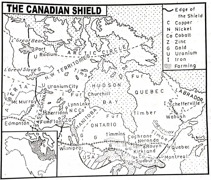
Chapter 9 North America: The Canadian Shield Region
Introduction: The word ‘Shield’ refers to an ancient landmass of an undulating surface formed by hard rock. There are eleven important shield regions all over the world. Among them, the Canadian Shield is the largest.
An ancient plateau or a highland of hard rock located in the northeastern part of Canada and bordering the Hudson Bay on the east, west, and south is called the “Canadian Shield”. This is also known as the “Laurentian Shield”.
Location: The Canadian shield region latitudinally extends from 42° north latitude (from the south) to 82° North latitude (in the north) and longitudinally it extends from 52° west longitude (in the east) to 120° west longitude (in the west).
Boundary: It extends from the Labrador plateau in the east to the shores of the Great Bear, Great Slave, Athabasca, and Winnipeg lakes in the west and from the shores of the ‘Five Lakes’ in the south to the Arctic Ocean in the north.
Area: The Canadian Shield Region covers an area of about 5-2 million square kilometers.
Physiography: The Canadian Shield region is a part of the world’s most ancient landmass. The land is a rolling peneplain with an average height of 200 to 500 meters.
This shield is very old hard rocks were scraped bare of soil by glaciers during the Ice Age. The glaciers with rock debris froze into them. Innumerable lakes found on its surface are actually the results of glaciation.
It is mostly made up of hard granite and gneiss. To the east, the shield is about 900 meters high. In some places of this region due to erosion, a few depressions had been developed in the surface causing the origin of lakes in such areas as Athabasca, Great Bear, Great Slave, etc. The slope of the region is from south to north.
“Class 8 WBBSE Geography Chapter 9 North America, multiple-choice questions”
Rivers and Lakes: The rivers of the Canadian Shield region flow from south to north and drain out at Hudson Bay. The rivers are Albany, LaGrande Saskatchewan, Mckenzee, Nelson, and Churchill.
St. Lawrence is the most important river and marks the south boundary of the region. Many of the rivers of this region have large waterfalls or rapids which are tapped to generate hydel power. Many lakes, which are located side by side, are connected by these rivers.
Climate: The region has very long cold winters with heavy snow and summers. Rainfall averages 40 cm in the west and rises to over 80 cm in the east. temperature varies between 10°C in the North to 16°C in the South. Nort ern pa region is under the severely cold Tundra climatic region.
Soil: The soil cover of this region is very thin. In some areas, glaciers deposited unsorted materials like boulders, gravel, sand, and sticky clay in sheets to form drift plans on the lowland. These drift plains are generally fertile and are good for mixed farming.
Natural Vegetation: No large trees cannot exist except moss lichen, algae, and small shrubs in the north where the Tundra climate prevails. Coniferous trees like pine, spruce,fir, etc. grow in the south. Mixed forests of coniferous trees and deciduous trees like oak and maple are found in the southeastern part of the region.
Animals: Wild animals like reindeer, wild cat. white fox, beaver provide urs are found here.
Chapter 9 North America: Economic Environment Of The Canadian Shield
Agriculture: The Canadian Shield region is not very suitable for agriculture due to
- Short summer,
- Severely cold climate,
- Infertile soil and sparse population.Farmers produce
- Wheat,
- Barley,
- Oats,
- Potatoes,
- Flax and
- Vegetables only in the fertile glacial clay belt around Hudson Bay and in the St. Lawrence river valley.
Lumbering: In summer after the melting of ice, the timber easily reaches to sawmills through the river currents. Lumbering is well developed in this region as well as Canada due to the abundant supply of timber.
Fishing: Fishing is commercially practiced in as many as 600 lakes.
Animal Rearing: Animals like sheep and cattle are also reared in the same area.
Mineral Resources and Mining: The Canadian Shield region is most important for its minerals. This region is the richest mineral field of North America. Sudbury supplies about half of the world’s nickel output. Important minerals produced in this region include.
| 1. Nickel | Sudbury (World’s largest 50% nickel mine), Thompson. |
| 2. Copper ore | Sudbury and Noranda district, Timinis. |
| 3. Gold | Porcupine, Kirkland, Noranda, Rouyn, Timinis, and Yellowknife |
| 4. Iron-ore | Schefferville and Wabush city on the Labrador-Quebec border. |
| 5. Uranium | Uranium City and Port Radium. |
| 6. Lead | Flin Flon; Pine Point, Noranda. |
| 7. Zinc | Flin Flon, Pine Point, Noranda. |
| 8. Cobalt | Sudbury region. Thompson, Sherridon. |
| 9. Silver | Flin Flon, Sudbury, Thompson, Sherridon |
| 10. Platinum | Sodbury, Thompson, Sherridon. |
Class 8 Geography Chapter 9
The Canadian Shield also ranks first in asbestos, second in magnesium and third in silver production in the world. Timinis is the second largest goldmine in the world. Though this shield region excavated many minerals but mining activities are restricted greatly here due to some factors. These are as follows:
- Adverse climatic conditions,
- Sufficient manpower,
- Great Expanse
- Few ice-free navigable rivers and
- The lack of transport facilities, partially in the northwest.
Industry: Though this region is sparsely populated and agriculture but there are some factors that have led to the growth of many industries. These are as but there are some factors which have led to the growth of many industries.
These are as follows—
- Availability of fur, softwood, good pastures, and minerals.
- Hydel power is generated from the local rivers.
- Cheap water transport and good air transport.
- A sufficient supply of labor.
- The assistance of high-quality Canadian technology.
- Sufficient financial patronage.
With the help of these factors, in the southern part of the Canadian shield region, different types of industries have been agglomerated forming the basis of economic prosperity in this region.
| Name of the Industry | Producing Centres | Products |
| 1. Paper Industry | Pine Point, Thunder Bay, Winnipeg, Ottawa, Montreal | Paper, Paper Pulp, Newsprint. |
| 2. Lumbering Industry | Ottawa, Porcupine, Quebec | Wood and wood pulp. |
| 3. Dairy Industry | Quebec | Milk dairy products and butter, cheese, paneer |
| 4. Fur Industry | Winnipeg, Toronto, Montreal | Leather-based apparels |
| 5. Rayon Industry | Toronto, Montreal, Ottawa | Different sophisticated materials |
| 6. Iron and Steel Industry | Sault St. Marie. | Iron and steel |
| 7. Engineering Industry | Montreal, Ottawa, Quebec | Different types of machinery and electronic gadgets |
| 8. Metal Industry | Ontario, Alberta | Different types of metals |
Timber and Paper Industry: The Canadian Shield region is developed in Timber and paper industries. There are some factors that have led to the growth of these industries.
These are as follows:
- There is an extensive coniferous forest that grows over this region which is the worlds second-largest in size(after Russian Taiga)soft timber of this forest is the main raw material of paper industry.
- The logs are collected by the river current cheaply.
- This region is developed in hydel power by swift-flowing rivers.
- Modern machinery helps to develop this industry.
- Supply of efficient labor and
- Sufficient financial patronage.
“WBBSE Class 8 North America notes, Chapter 9 worksheet”
Due to the above factors, the Canadian Shield region is well-developed in Timber and paper industry.
Population: Because of the extremely cold climate Canadian Shield region is sparsely populated. Eskimos live in the northern part of the region.
Major Cities: Important cities of the Canadian Shield region.
Ottawa(1 million in 2001): Ottawa on the Ottawa river, a tributary of St. Lawrence, is the capital of Canada.
Thunder Bayon Lake Superior, Sudbury on the Huron, and Churchill on the Hudson Bay are important cities. Sault St Marie, Winnipeg, and Thompson, etc are also important cities.
WBBSE Notes For 8 Class Middle School Geography
- Chapter 1 Interior Of The Earth Notes
- Chapter 2 Unstable Earth Notes
- Chapter 3 Rocks Notes
- Chapter 4 Pressure Belts And Winds Notes
- Chapter 5 Cloud And Rain Notes
- Chapter 6 Climatic Regions Notes
- Chapter 7 Human Activities And Environmental Degradation Notes
- Chapter 8 Some Neighbouring Countries Of India Notes
- Chapter 10 South America Notes
- Chapter 11 Oceania Notes