Class 10 Geography WBBSE Chapter 2 Atmosphere True Or False Type:
Question 1. Mistral is a warm local wind which blows over Rhone valley in France.
Answer: False
Question 2. Wind velocity is measured with the help of an Anemometer.
Answer: True
Question 3. The air pressure is measured with the help of Fortin’s Barometer.
Answer: True
Read and learn all WBBSE Solutions For Class 10 Geography And Environment
Question 4. The ozone layer is known as “Natural sun-screen”.
Answer: True
Question 5. In Mediterranean regions, rainfall generally occurs in summer.
Answer: False
School Geography Class 10 WBBSE
Question 6. Nitrogen occupies about 21% of the atmosphere by volume.
Answer: False
Question 7. Conduction is the process by which heat is transferred by contact.
Answer: True
Question 8. Vertical rays are cooler than slanting rays.
Answer: False
Question 9. The normal Lapse Rate is 0.6°C per 100 m.
Answer: True
Question 10. Mercury has a freezing point of —40°C.
Answer: True
Question 11. Alcohol has a freezing point of -130°C.
Answer: True
Question 12. A hygrometer measures the relative humidity.
Answer: True
Question 13. The lowest layer of the atmosphere is the stratosphere.
Answer: False
Question 14. Convectional rainfall mainly occurs in the equatorial region.
Answer: True
Question 15. Insolation is the incoming solar energy.
Answer: True
Question 16. There are seven heat zones.
Answer: False
Question 17. There are five pressure belts.
Answer: False
Question 18. An anemometer measures wind velocity.
Answer: True
Question 19. Windvane determines the direction of the wind.
Answer: True
School Geography Class 10 WBBSE
Question 20. Fohn is a local wind.
Answer: True
Question 21. Monsoon is a periodical wind.
Answer: True
Question 22. Trade winds are planetary winds.
Answer: True
Question 23. Orographic rainfall occurs at the windward side of the mountain.
Answer: True
Question 24. Brave westerlies flow in between 40-60 north latitudes.
Answer: False
Question 25. The humidity of air is measured by a hydrometer.
Answer: False
Question 26. Sixty-six per cent of the solar rays is responsible for the heating of the atmosphere.
Answer: True
Question 27. The wind velocity is so high and roaring at 40°S latitude that it is called horse latitude.
Answer: False
Question 28. The upper atmosphere is so thin that there is not enough air to breathe.
Answer: True
Geography Class 10 West Bengal Board Chapter 2 Atmosphere Fill In The Blanks Type:
Question 1. Oases are formed by ______ action of wind.
Answer: Deflation.
Question 2. _______ is formed by the mixing of dust and fog during winter in the industrial region.
Answer: Fog
Question 3. Tropical easterly Jet Stream forces ______ wind to blow over India.
Answer: Monsoon
Question 4. Temperature increases with the increase of altitude in the atmosphere is called _______.
Answer: Inversion of temperature.
School Geography Class 10 WBBSE
Question 5. In the Rainfall-Temperature graph of any place, if the temperature curve becomes downward sloping during the middle of the year then the station lies in ______ hemisphere.
Answer: Southern.
Question 6. In the southern hemisphere, an anti-cyclone moves _______.
Answer: Anti-clockwise.
Question 7. Fog is caused in the atmosphere due to ______ of water vapour.
Answer: Condensation.
Question 8. The relative humidity of the air is measured by ______.
Answer: Hygrometer.
Question 9. _______ rainfall occurs in the equatorial region in the afternoon.
Answer: Conventional.
Question 10. The rainshadow area is found on the _______ slope of the mountain.
Answer: Leeward.
Question 11. The relative humidity is expressed in _______.
Answer: Percentage.
Question 12. The sea breeze blows during ______.
Answer: Day.
Question 13. The range of temperature is maximum in the ______ region.
Answer: Desert.
Question 14. Rainfall is ______ on the leeward side.
Answer: Scanty.
Question 15. Convectional rainfall occurs in ______ region.
Answer: Equatorial.
Question 16. The line which connects the places with equal pressure of air is called ______.
Answer: lobar.
Question 17. The most abundant gas in the atmosphere is ______.
Answer: Nitrogen.
Question 18. The pressure of air at sea level is ______ millibar.
Answer: 1013.
Question 19. Two major constituent gases of air include nitrogen and ______.
Answer: Oxygen.
Question 20. ______ is a line joining places having an equal temperature.
Answer: Isotherm.
Question 21. _______ is a line joining places having equal pressure.
Answer: Isobar.
Question 22. _______ is a line joining places having equal rainfall.
Answer: Isohyet.
Question 23. ______ is the maximum rain-giving cloud.
Answer: Nimbus.
Question 24. _______ is a hot wind blowing over the rocks.
Answer: Chinook.
Question 25. ________ is a cold wind blowing over France.
Answer: Mistral.
Geography Class 10 West Bengal Board
Question 26. The climate of the place far off the ocean is of _______ type.
Answer: Continental.
Question 27. The expansion of the atmosphere is _______ km.
Answer: 10,000 km:
Question 28. Loo is a _______ wind.
Answer: Temporary.
Question 29. The lowermost layer of the atmosphere is called _______.
Answer: Troposphere.
Class 10 Geography WBBSE Chapter 2 Atmosphere Very Short Answer Type Questions:
Question 1. Where in the atmosphere over the earth’s surface ozone hole was first discovered?
Answer: Antarctica.
Question 2. Which type of rainfall is found in the Temperate zone?
Answer: Cyclonic rain.
Question 3. Which island of Sundarban was completely submerged due to global warming?
Answer: Lohachara, Needmore.
Question 4. In which layer of the atmosphere jet plane flies?
Answer: Stratosphere.
Question 5. What is the relative humidity of saturated air?
Answer: 100%.
Geography Class 10 West Bengal Board
Question 6. Name the instrument by which relative humidity is measured.
Answer: Relative humidity is measured by Hygrometer.
Question 7. Give a single term for each of the following:
1. The zone which separates the troposphere from the stratosphere.
2. The layer of the atmosphere where conditions are ideal for flying.
3. The layer of the atmosphere which reflects the radio waves back to the earth’s surface.
4. The vast expanse of air which envelopes the earth all around.
5. The atmosphere layer lies between the stratosphere and the ionosphere.
6. The uppermost layer of the atmosphere.
Answer:
1. Tropopause.
2. Stratosphere.
3. ionosphere.
4. Atmosphere.
5. Mesosphere.
6. Exosphere.
Question 8. Where is the coldest place on earth?
Answer: The pole of cold (78°S, 96°E) in Antarctica with an annual mean of — 72°F is the coldest place on earth.
Question 9. Where is the world’s desert place?
Answer: Calama, in the Atacama desert, Chile.
Question 10. What is isohyet?
Answer: Isohyet is an imaginary line joining places of equal amounts of rainfall. Isohyet is mainly used in the climatic map.
Question 11. Where is the foggiest place on earth?
Answer: The Grand Banks, Newfoundland, Canada where at sea-level fog persists for more than 120 days a year.
Question 12. What is the imaginary line joining places having equal temperatures called?
Answer: Isotherm.
Question 13. What is the warm, nutrient-poor water of Northern Peru called?
Answer: El Nino.
Question 14. Name the instrument used to measure air pressure.
Answer: Barometer.
Question 15. What do we call the winds that blow from one direction throughout the year?
Answer: Planetary winds.
Question 16. What is the warm dry wind blowing along the leeward slope of the Alps called?
Answer: Foehn.
Question 17. Name the rainfall that occurs in the presence of a mountain or plateau.
Answer: Orographic rainfall.
Question 18. What is the height of the atmosphere according to the latest discoveries?
Answer: 32,000 km.
Geography Class 10 Solutions WBBSE
Question 19. What are the major constituents of pure dry air?
Answer: Gases.
Question 20. Which gas is most essential for life?
Answer: Oxygen.
Question 21. Name the gas which is found in the lower part of the atmosphere.
Answer: Carbon dioxide.
Question 22. Which gas is mainly found in the upper part of the atmosphere?
Answer: Hydrogen.
Question 23. Which gas absorbs ultraviolet radiation from the sun?
Answer: Ozone.
Question 24. Name two major constituents of the atmosphere apart from the gases.
Answer: Water vapour and dust particles.
Question 25. Name the main layers of the atmosphere.
Answer: Troposphere, stratosphere, mesosphere, ionosphere and exosphere.
Question 26. Which atmospheric layer is most important for us?
Answer: Troposphere.
Question 27. What is the average height of the troposphere?
Answer: 16 km.
Question 28. What is the height of the troposphere at the equator and the poles respectively?
Answer: 18 km and 8 km respectively.
Geography Class 10 Solutions WBBSE
Question 29. Name the thin layer which separates the troposphere from the stratosphere.
Answer: Tropopause.
Question 30. How much is the normal lapse rate in the troposphere?
Answer: 1°C for 165 metres or 6.4°C for 1 km.
Question 31. Which layer of the atmosphere reflects radio waves?
Answer: the ionosphere.
Question 32. Why do jet planes prefer to fly higher than ordinary planes?
Answer: To avoid lumpy air pockets of the Troposphere.
Question 33. What is the unit of measuring ozone?
Answer: Dobson Unit (DU).
Question 34. Which gas is mainly responsible for ozone layer depletion?
Answer: Chlorofluorocarbon (CFC).
Question 35. Where is the ozone hole?
Answer: Over the Antarctica continent.
Question 36. What part of solar radiation is received by earth?
Answer: Two billionth part.
Question 37. Through which processes atmosphere is heated?
Answer: Radiation, condensation, convection and advection.
Question 38. What is the unit of measuring insolation?
Answer: Calorie.
Question 39. What is the standard sea-level pressure in millibars?
Answer: 1013.25 millibars.
Question 40. What is the rate of fall of atmospheric pressure with height?
Answer: 34 millibars per every 300 metres.
Geography Class 10 Solutions WBBSE
Question 41. Which unit of atmospheric pressure is used while drawing an isobaric map?
Answer: Millibar.
Question 42. Name the effect or force due to which winds are deflected from their path as a result of the earth’s rotation.
Answer: Coriolis effect.
Question 43. By which law is Coriolis force known?
Answer: Buys Ballot’s law or Ferrel’s law.
Question 44. Where do you find the maximum and minimum deflection of winds by the Coriolis effect?
Answer: At the poles and equator respectively.
Question 45. Name two permanent winds.
Answer: Trade winds and westerlies.
Question 46. Between which latitudes do westerlies blow?
Answer: 30°N and S latitudes.
Question 47. What is the direction of the flow of trade winds in the northern hemisphere?
Answer: From northeast to the southwest.
Question 48. Between which latitudes do westerlies blow?
Answer: From 30°—40° to 60°—-65° latitudes.
Question 49. Where do the Roaring Forties, Furious Fifties and Shrieking Sixties blow respectively?
Answer: At 40°, 50° and 60° South latitudes respectively.
Question 50. What is the literal meaning of Chinook?
Answer: Snow-eaters.
Question 51. Through which valley mistral wind blows?
Answer: Rhone valley.
Question 52. Name two broad types of cyclones.
Answer: Temperate and tropical cyclones.
Question 53. What are the two other names of temperature cyclones?
Answer: Depressions and western disturbances.
Geography Class 10 Solutions WBBSE
Question 54. Who propounded the polar front theory of the origin of temperate cyclones?
Answer: Vilham Bjerkens and his son Jacob Bjerkens.
Question 55. Where is the eye of a tropical cyclone located?
Answer: At its centre.
Question 56. What does ITCZ stand for?
Answer: Inter-tropical convergence zone.
Question 57. Give one technical term for each of the following:
1. An imaginary line drawn through places having equal atmospheric pressure reduced to sea level.
2. Air that moves horizontally along the earth’s surface.
3. Deflecting force due to rotation of the earth.
4. Winds blowing over the south and southeast Asia are characterized by a reversal in wind direction with a change in a season.
5. Winds blowing from the sub-tropical high-pressure belts towards the sub-polar low-pressure belts.
6. A warm dry wind, known as a snow-eater, blows on the eastern side of the Rocky Mountains.
7. A large body of air with uniform properties of temperature and humidity.
8. The contact line between air masses of different properties.
9. Azone of calmness in the vicinity of the equator on both sides.
10. An air mass originating over tropical oceans.
Answer:
1. Isobar,
2. Wind,
3. Coriolis force,
4. Monsoon winds,
5. The westerlies,
6. Chinook,
7. Air mass,
8. Front,
9. Doldrum,
10. Tropical Maritime.
Question 58. What is a ‘ Jet Stream’?
Answer: A jet stream is a high-altitude air movement consisting of very strong winds concentrated in a narrow belt.
Question 59. Give a single technical term for each of the following:
1. The process by which water is transformed from liquid to vapour or gas.
2. The amount of water vapour actually present in per unit volume of air.
3. The amount of water vapour actually present in per unit weight of air.
4. Ratio of the amount of water vapour actually present in the air at a particular temperature to the amount of water vapour required to saturate the same air at the same temperature.
5. The air that contains moisture to its full capacity.
6. The process of change of state from gaseous to liquid or solid forms of water.
7. The temperature at which condensation starts.
8. Falling of the frozen raindrops and refrozen melted snow on the earth’s surface.
Answer:
1. Evaporation,
2. Absolute humidity,
3. Specific humidity,
4. Relative humidity,
5. Saturated air,
6. Condensation,
7. Dew point,
8. Sleet.
Geography Class 10 Solutions WBBSE
Question 60. Name the factors controlling the rate of evaporation.
Answer:
1. Temperature,
2. Dryness of air,
3. Clouds,
4. Size of the water area,
5. Movement of air.
Question 61. Name three forms of humidity.
Answer:
1. Absolute humidity,
2. Specific humidity,
3. Relative humidity.
Question 62. What is the unit of measurement of relative humidity?
Answer: Present.
Question 63. Name various forms of precipitation.
Answer:
1. Snowfall,
2. Sleet,
3. Hail-fall,
4. Rainfall.
Question 64. Which type of rainfall generally occurs in the equatorial region?
Answer: Convectional rainfall.
Question 65. Which type of rainfall is associated with the following:
1. Convection currents,
2. Relief,
3. Convergence of cold and warm air masses?
Answer:
1. Convectional rainfall,
2. Orographic rainfall,
3. Cyclonic rainfall.
Question 66. Which part of South India receives orographic rainfall?
Answer: Western Ghats and West Coastal plains.
Question 67. What type of rainfall occurs in northwest India during winter?
Answer: Cyclonic rainfall.
Geography Class 10 Solutions WBBSE
Question 68. What climatic data are used for classifying climates?
Answer: Temperature and precipitation.
Question 69. Which type of climate is known for the minimum annual range of temperatures?
Answer: Equatorial climate.
Question 70. In which climate evaporation is higher than precipitation?
Answer: Desert climate.
Question 71. Which climate has rainfall in winter and practically no rainfall in summer?
Answer: Mediterranean climate.
Question 72. What is the significance of the 10°C summer isotherm?
Answer: It marks the southern boundary of the Tundra climate.
Question 73. Listed below are some important characteristics of a few climate types. Name the climatic types of which they refer to:
1. High temperature throughout the year, wet summers and dry winters.
2. Greatest daily ranges of temperature on the earth.
3. Reversal in wind direction with a change of season.
4. Constantly high temperatures and heavy precipitation throughout the year.
5. Warm and dry summer, mild winter, moderate rainfall mostly in winter.
6. Short summer temperature ranging between 10°C to 15°C, long and very cold winters, and low precipitation mostly in warmer months.
7. Severe winter, cool summer with temperature not rising above 10°C.
Answer:
1. Wet and dry (Savanna) climate,
2. Desert climate,
3. Monsoon climate,
4. Equatorial climate,
5. Mediterranean climate,
6. Boreal (Taiga) climate,
7. Tundra climate.
Geography Class 10 Solutions WBBSE
Question 74. Which type of cloud produces the maximum rainfall?
Answer: Cumulonimbus (Cu-Ni) cloud is a type of cloud which produces maximum rainfall.
Question 75. How many pressure belts are there on the surface of the earth?
Answer: There are seven pressure belts on the surface of the earth.
Question 76. Give an example of periodic wind.
Answer: Monsoon is an example of periodic wind.
Question 77. What is Terrestrial radiation?
Answer: The sun’s energy absorbed by the Earth’s surface when radiated out into space is called terrestrial radiation.
Question 78. What is the weight of the atmosphere?
Answer: 9046 thousand crore tones.
Question 79. Name two scientists who divided the atmosphere into two parts — Homosphere and Heterosphere.
Answer: Jastrio and Nicholas.
Question 80. Who invented the term ‘Tropopause’?
Answer: Sir Napier Shaw.
Question 81. In which layer of the atmosphere does aeroplanes fly?
Answer: Stratosphere layer.
Question 82. What is insolation?
Answer: Radiant energy from the sun that strikes the earth is called Insolation.
Question 83. What is the barometric slope or pressure gradient?
Answer: The difference of pressure between any two places is called pressure gradient or barometric slope.
Question 84. What do you mean by ITCZ?
Answer: The meeting zone of the trade winds and the equatorial westerlies is called the Inter Tropical Convergence Zone (ITCZ),
Question 85. What is the unit of measurement of clouds?
Answer: Okta or Tenths.
Question 86. Name the scale for ascertaining the speed of the wind.
Answer: Beaufort scale.
WBBSE Class 10 Geography Solutions
Question 87. What is heat balance?
Answer: The amount of energy received and lost by the atmosphere is called the heat balance.
Question 88. What is insolation?
Answer: The incoming solar radiation is called Insolation.
Question 89. What do you mean by daily range of temperature?
Answer: The daily range of temperature is the difference between the highest and the lowest temperature over a period of 24 hours.
Question 90. What do you mean by daily mean temperature?
Answer: The daily mean temperature is the mean of the maximum and the minimum temperatures of 24 hours.
Question 91. What do you mean by a diurnal range of temperature?
Answer: Diurnal range of temperature is the difference between the maximum and the minimum temperatures of a day.
Question 92. What do you mean by mean monthly temperature?
Answer: Mean monthly temperature is the average of the mean temperatures of all days in a month.
Question 93. What do you mean by an annual range of temperature?
Answer: Annual range of temperature is the difference between the mean temperature of the hottest month and that of the coldest month in a year.
Question 94. What is a pressure gradient?
Answer: The rate of fall of pressure per unit of horizontal distance.
Question 95. What is atmospheric pressure?
Answer: The force exerted by the vertical column of air per unit of area is called atmospheric pressure.
Question 96. Give an example of periodic wind.
Answer: A monsoon wind is a periodic wind.
Question 97. Name the instrument by which air temperature is measured.
Answer: Six’s thermometer.
School Geography Class 10 WBBSE Chapter 2 Atmosphere 2 Marks Questions And Answers:
Question 1. What is Doldrum?
Answer:
Doldrum: The equatorial region (the latitudes between 5°N and 5°S) is generally known as doldrum or equatorial calm. Over the equatorial region due to the continuous ascent of warm-moist air, there is no horizontal flow of air. So it is known as a doldrum.
Question 2. What is “inversion of temperature”?
Answer: Generally there is a decrease in temperature as we ascend upward above sea level, but sometimes temperature increases as we ascend upward. This is known as “Inversion of temperature”.
WBBSE Class 10 Geography Solutions
Question 3. What is ‘Chinook’?
Answer:
Chinook: Chinook is a warm, dry, gusty wind blowing down the Rocky mountains by the eastern slopes into the western prairies.
Question 4. Mention two characteristic features of Jet Streams.
Answer:
Characteristic features of Jet Streams:
1. It blows from west to east.
2. Length of the jet stream can be a few thousand kilometres.
Question 5. Discuss the relationship between Jet Stream & Monsoon.
Answer:
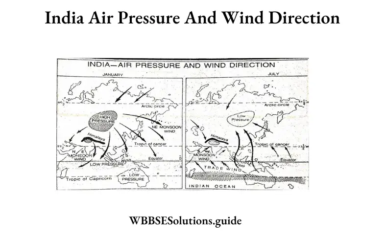
Relation between Jet Stream and Monsoon wind: The westerly jet stream causes high pressure on the Indian subcontinent in winter. Hence the monsoon winds start retreating. During the summer, the Tibet plateau gets excessively heated and drives the sub-tropical westerly jet stream north of the Himalayas.
The tropical easterly jet stream blows through the centre of the Indian subcontinent, causing low-pressure conditions. This gradually attracts the monsoon winds. The onset of the monsoons depends on the shifting of the sub-tropical jet stream towards the north.
As fast as this westerly jet moves northwards, the Tropical easterly jet sets in, and the monsoon winds are attracted. The sudden shift of the westerly jet stream northwards may cause a huge ‘Monsoon burst’.
Question 6. What do you mean by saturation & due point?
Answer: Saturation and Dew point: Air is said to be saturated when it contains water vapour in its full capacity. The temperature at which the air is saturated and below which condensation (the transformation of water vapour into water or ice) begins, is called the dew point.
Question 7. What is Meteorology?
Answer: Meteorology is the study of the atmosphere, and as the movements and composition of the atmosphere determine weather patterns, meteorology is the study of weather.
Question 8. If the temperature at sea level is 25°C, under average conditions, what would the air temperature be at a height of 2km?
Answer: The temperature decreases with the height at the rate of 1°C per 165 m. Therefore, for a height of 2 km or 2000 m the decrease in temperature \(\frac{2000}{165}\)= is 12°C nearly.
Therefore the temperature at the height of 2 km will be = 25°C— 12°C = 13°C.
Question 9. What is meant by the horizontal distribution of temperature?
Answer: Temperature varies from latitude to latitude. The horizontal distribution of temperature means the distribution of temperature according to latitude. It is shown by isotherms. In this distribution, the effect of altitude is eliminated so that the temperatures are reduced to sea level.
WBBSE Class 10 Geography Solutions
Question 10. Explain when minimum temperature occurs.
Answer:
The daily minimum temperature: The lowest temperature of the day is called the daily minimum temperature. The minimum temperature is not found at midnight. It is found at midnight. It is found at about 4 a.m. in the morning when the earth becomes cold due to rapid radiation. So the lowest temperature is found in the early hours of the morning.
Question 11. Explain the mean daily temperature of a place.
Answer:
Mean daily temperature: The average of the maximum temperature and minimum temperature recorded during a day is known as the mean daily temperature.
\(\text { Mean daily temperature }=\frac{\text { Max. temperature }+\text { Min. temperature }}{2}\)
For example, if a place has a maximum temperature of 42°C and minimum temperature of 28°C for a particular day, the mean daily temperature \(\frac{42^{\circ} \mathrm{C}+28^{\circ} \mathrm{C}}{2}\)= 35°C.
Question 12. Why are isotherms generally parallel to the parallels of latitude?
Answer: The isotherms generally trend east to west roughly parallel to the lines of latitudes. It is observed that the length of the day and the angle of the sun- rays are equal on all parts of the same parallel. All places on a parallel receive the same amount of insolation and have equal temperatures.
Therefore, the isotherms joining the places of equal temperature run roughly parallel to the lines of latitude. Thus due to the similarity between the distribution of insolation and latitude, isotherms follow parallels of latitude.
Question 13. Name the two factors which control the amount of insolation.
Answer:
The two major factors controlling the amount of insolation received on the earth’s surface are:
1. Intensity of insolation or the angle of incidence of sun rays.
2. The duration of solar radiation or length of the day.
All the places on the same parallel receive the same amount of insolation because the length of the day and the angle of the sun’s rays are equal on all parts of the same parallel.
Question 14. What is the relationship between heating, temperature and pressure?
Answer: There is a direct relation between heating, the temperature of air and atmospheric pressure. The chain of events follows from heating through temperature to pressure.
The land is heated through insolation. The air close to the surface is heated through conduction. Heating causes the expansion of air. It results in a decrease in convection. This leads to the development of low pressure as in the equatorial region.
Question 15. Why can clouds in tropical thunderstorms reach much greater heights than clouds in temperate areas?
Answer: The troposphere is 16-18 km high near the equator but only 10-11 km in the mid-latitudes. So clouds can rise higher in tropical areas.
WBBSE Class 10 Geography Solutions
Question 16. How is dew formed? How does it differ from fog formation?
Answer: When a layer of calm humid air immediately in contact with the ground is cooled, water may be formed directly on the cooler objects. This is dew. It is a contact process and no falling of water from the air is involved as in a fog.
Question 17. What is meant by the hydrological cycle?
Answer: By hydrological cycle we mean the movement of moisture from the ocean surfaces (or any other water surface) to the land where it is precipitated, and its ultimate return by evaporation and run-off to the sea.
Question 18. What do you understand by horse latitudes?
Answer:
Horse Latitudes: In the middle ages sailing ships carried a large number of horses and while crossing the subtropical belt of calm in the northern hemisphere they were stranded due to no horizontal movement of winds at these belts.
To reduce the load of the ships so that with little wind they could move, many horses were thrown overboard. In the northern hemisphere, the region between 30° to 35° N latitudes are, therefore, known as horse latitudes.
Question 19. What is ozone layer depletion?
Answer: CFC, CH4,H2o and other pollutants escape into the stratosphere and cause destruction of o3 there. This is known as ozone layer depletion.
Question 20. What is the weather like?
Answer: The total sum of atmospheric conditions of a particular place at a given time is known as weather. It refers to a very short period of time.
Question 21. What is climate?
Answer: Climate is the atmospheric conditions of a very large area over a long period of time. It generally refers to those over 35 years.
Question 22. What do you understand by heat budget?
Answer: The amount of energy received and lost by the atmosphere is called the heat budget.
Question 23. Mention two effects of ozone layer depletion.
Answer: Two major effects of ozone layer depletion are:
1. The incidence of skin cancer and cataracts increases.
2. Diminishes the immune system.
WBBSE Class 10 Geography Solutions
Question 24. What is an ozone hole?
Answer: The decline in ozone layer thickness is termed as an ozone hole.
Question 25. Why is the stratosphere considered ideal for flying jet aircraft?
Answer: The stratosphere has no water vapour and dust particles. Air turbulence and clouds are absent and due to the absence of weather disturbances, this layer is considered ideal for flying jet aircraft.
Question 26. Write two differences between the normal lapse rate and inversion of temperature.
Answer:
| Normal lapse rate |
Inversion of temperature |
| (1)The decrease in temperature with increasing height is called the lapse rate. |
(1)The increase in temperature with increasing height is called inversion of temperature. |
| (2)The lapse rate is higher in tropical areas than in polar areas. |
(2)Inversion of temperature is a common phenomenon in mountain regions. |
Question 27. Differentiate between Anabatic wind and Katabatic wind.
Answer:
| AnabaticWind |
Katabatic Wind |
| (1) It is a valley wind. |
(1) It is a mountain wind. |
| (2) It blows from the valley’s bottom to the hillside slopes during the day. |
(2) It is a downhill wind, usually cold, blowing into the valley at night. |
Question 28. Why are the westerlies also called Anti-trade?
Answer: Westerlies are called Anti-trade also because their direction is opposite to that of the trade wind.
Question 29. What is a warm front?
Answer: A warm front is formed when a warm air mass is moving faster than the cold air so that warm air starts entering the air formerly occupied by the cold air.
Question 30. What is a cold front?
Answer: A cold front is formed when a cold air mass is moving faster and it starts replacing the warm air mass by invading in the area formerly occupied by warm air.
WBBSE Class 10 Geography Solutions
Question 31. What do you mean by precipitation?
Answer: Precipitation means ‘throwing down of moisture’ from the atmosphere. It is the collective name given to different forms of moisture falling on the earth from the condensation of water vapour in the atmosphere, such as:
1. Rainfall,
2. Snowfall,
3. Hail,
4. Sleet,
5. Dew and
6. Mist.
Question 32. What is Chinook?
Answer: Chinook is a type of local wind which is warm and dry and blows along the Eastern slopes of the Rockies into the Plains of Prairie. “Chinook” means snow eater.
Question 33. Why are cloudy nights warm?
Answer: Cloudy nights have more environmental humidity than clear-sky nights. Therefore, cloudy nights are warm.
Question 34. What are isobars and isotherms?
Answer:
Isotherms: isotherms are imaginary lines drawn on maps joining places having the same average temperature (reduced to sea level).
Isobar: An isobar is an imaginary line drawn on a map (or a weather chart) joining all areas having equal atmospheric pressure (reduced to sea level).
Question 35. What is relative humidity?
Answer:
Relative humidity: Relative humidity is the ratio between the actual amount of water vapour present in the air at a temperature and the maximum amount of water vapour which the same volume of air can hold at that temperature. This is expressed as a percentage.
Question 36. Write a note on Exosphere.
Answer: The exosphere is the outermost layer of the atmosphere which merges with the interplanetary medium, although there is no definite boundary with the ionosphere. It starts at a height of about 600 km. The composition of ratified gases mainly consists of a small amount of atomic oxygen up to 600 km and an equal proportion of hydrogen and helium with hydrogen predominating above 2400 km.
WBBSE Class 10 Geography Solutions
Question 37. What are the unique features of the ionosphere?
Answer: Air particles of the ionosphere are electrically charged by the sun’s radiation and congregate in four main layers : D, E, F, & F, which can mainly reflect radiowaves.
Aurora is caused by charged particles deflected by the earth’s magnetic field towards the poles (which occur between 65-965 km above the surface of the earth). The meteors from outer space burn up in this layer as they meet increased air resistance.
Question 38. What is the atmosphere?
Answer: The atmosphere is the gaseous blanket that encircles the earth.
Question 39. How many pressure belts are there on the surface of the earth?
Answer: There are seven pressure belts over the earth’s surface. Four of them are high-pressure belts and three are low.
Question 40. What is Fohn?
Answer: A hot dry wind blows over the northern slopes of the Alps and Rhine valley. The warm wind helps in snow melting & gives rise ‘to pasture in Rhine valley. This local wind is Fohn.
Question 41. What is the normal lapse rate?
Answer: Under normal conditions, temperature decreases with increasing height at the rate of 0-6°C per 100 metres, it is known as the normal lapse rate.
Question 42. What is ‘Doldrum?
Answer: A region calm on the equatorial belt (5° N & S) which has no horizontal movement of air, is called ‘Doldrum’.
Question 43. What is Heterosphere?
Answer: In the layer above the Homosphere, the percentage of gases varies and shows heterogeneous character and for this reason, the upper layer of the atmosphere is known as Heterosphere.
Question 44. What is Ferrel’s law?
Answer: Winds do not blow in a straight line. They change their direction while blowing. This is due to the rotational movement of the earth. In the northern hemisphere they deflect to the right while in the southern hemisphere, they deflect to left. This rule is known as Ferrel’s law. It is also applicable to an ocean current.
Question 45. What are planetary winds?
Answer: Planetary winds are permanent winds which originate due to the rotational movement of the earth. Example: Trade winds.
WBBSE Class 10 Geography Chapter 2 Atmosphere Short Notes:
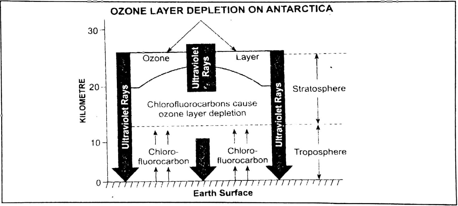
Question 1. Ozone Depletion.
Answer:
Ozone Depletion: The extensive use of man-made chemicals called CFCs (Chlorofluorocarbons) has been confirmed to be the cause of the Antarctic ozone hole. CFC gases are used in refrigerators, aircraft and air-conditioners. CFC compounds escape into the atmosphere and finally break down in the stratosphere. They produce chlorine atoms which destroy the ozone layer. This phenomenon is termed as ozone depletion.
Question 2. Sea Breeze.
Answer:
Sea Breeze: During the daytime, the land gets rapidly heated up than the sea. The warm air rises to form a low pressure locally on land. The sea being cooler develops a high pressure. So a cool sea breeze blows from sea to land. Thus the winds complete a convection cycle.
Effects:
1. It brings cool and fresh air from the sea.
2. Sea breeze moderates the temperature of the coastal areas resulting in an equable or maritime climate.
3. Its influence does not exceed 20 miles from the coast.
WBBSE Class 10 Geography Chapter 2 Question Answer
Question 3. Land Breeze.
Answer:
Land Breeze: During the night the land becomes cooler than the sea. The cold and heavy air produces a local high pressure on land. The sea remains comparatively warmer with low pressure. Therefore, a land breeze blows from land to sea.
These are effective under a calm, cloudless sky.
1. The fishermen take advantage of the outgoing land breeze and sail out in the morning. They return with the incoming sea breeze in the evening.
2. The return current of warm air from the sea has a moderating effect on the temperature.
Question 4. Isobars.
Answer:
Isobars: Isobar is a combination of two words (Iso = equal, Bar = Pressure), So isobars are lines of equal pressure.
Isobar is an imaginary line joining places of equal pressure reduced to sea level. Pressure is reduced to sea level to eliminate the effects of altitude. Isobars, thus, show the distribution of pressure as if the whole earth were a level plain.
Main Characteristics:
1. isobars generally run in an east-west direction.
2. In the southern hemisphere these closely follow the lines of latitudes.
3. These are more regular in oceans than on land.
4. Isobars are used to show the distribution of pressure on climatic maps.
Question 5. Buys Ballot’s law.
Answer: This law clearly indicates the relation between the wind & pressure. Buy Ballot’s law states that — Stand with your back to the wind in the northern hemisphere, the low pressure will be towards your left and the high towards your right and the reverse applies in the southern hemisphere.
Question 6. Ferrel’s law.
Answer: Based on the Coriolis force of the earth and the deflection of winds Ferrel has propounded his law which is popularly known as Ferrel’s law. Ferrel’s law states that — the body, including a current of air moving in any direction over the earth, is deflected due to the earth’s rotation to the right in the northern hemisphere and to the left in the southern hemisphere.
WBBSE Class 10 Geography Chapter 2 Question Answer
Question 7. Horse latitude.
Answer: In the middle ages sailing ships carried a large number of horses and while crossing the sub-tropical belt of calm in the Northern hemisphere they often got stranded due to horizontal movements of the winds in this belt. To reduce the load of the ships, many horses were thrown overboard in the Northern hemisphere so it is known as Horse latitudes.
Question 8. Ozone layer.
Answer: The ozone layer of the atmosphere is stretched over a distance of 10-35 kilometres from the ground. The presence of the ozone layer in the lower stratosphere protects the earth from the harmful effects of the ultraviolet rays of the sun. But it is said that recently this ozone layer has been depleted in some parts of the world.
Major pollutants for ozone depletion are chlorofluorocarbons, nitrogen oxides and hydrocarbons. CFC or chlorofluorocarbons is the main threat to the ozone layer which is used in refrigerators, air conditioners, cleaning solvents and aerosol propellants. If the ozone layer is depleted, the whole creation of the earth would fall in danger and life would be at stake.
Question 9. Relative humidity.
Answer: Relative humidity is the ratio between the actual amount of water vapour present in the air at a temperature and the maximum amount of water vapour which the same volume of air can hold at that temperature. This is expressed as a percentage.
Example: The air at 15°C temperature has 16 g of water vapour per cubic centimetre but actually the air at the same amount of temperature (i.e., 15°C) can hold 20 g of water vapour per cubic centimetre.
Relative humidity = 16/20 x 100 = 80%.
Question 10. Smog.
Answer: The term smog was coined from the two words ‘Smoke’ and ‘Fog’. Smog is, therefore, a fog which is heavily laden with smoke. It is commonly found in industrial and densely populated urban areas.
Question 11. Local Wind.
Answer: Local winds blow over a limited area and are caused by local pressure conditions and relief features.
They may be of several types:
1. In high mountainous regions, due to the rapid fall of temperature at night, cold and dense air may slide down the mountain slope to occupy the valley bottom as Katabatic winds to cause an inversion of temperature. The Mistral of Rhone valley in Southern France and Bora in Yugoslavia are examples of Katabatic winds.
2. When winds are forced to descend on the leeward side of a mountain barrier, the air becomes hot and dry, and such winds are known as Descending or Compression winds. The Chinook in the Rocky Mountains and Fohn in the Alps are examples of this type.
3. Desert winds like Harmattan of West Africa and Sirocco of the Mediterranean basin are hot and dry winds which blow from deserts.
WBBSE Class 10 Geography Chapter 2 Question Answer
Question 12. Troposphere.
Answer: This is the lowest layer of the atmosphere. It is up to a height of 16 km on the equator and at the poles, the height is 8 km. The main feature of this layer is that temperature decreases in relation to height (for every 100-metre height the decrease in temperature is 0.6°C). 75% of all the water vapour, cloud, and dust particles are found in this layer. That is why this layer is called the ‘weather-making layer’.
Question 13. Albedo.
Answer: The ratio of total solar radiation falling upon a surface to the amount reflected from it expressed as a decimal to percentage is known as Albedo. A global average of about 40% of the incoming solar energy is reflected back into space. The reflected power of the earth is known as the Earth’s Albedo.
Question 14. Nor’wester.
Answer: These are violent storm winds. These are called so because they come from the North-West. These Nor’westers are known as Kal Baishakhi in West Bengal. They are called Kal Baishakhi which means ‘calamity of the month of Baishakhi’ because they cause much destruction in West Bengal and they occur is the month of Baishakh according to the Bengali calendar. The convergence of dry North-Western wind and moist Southern wind causes thunderstorms.
Question 15. Homosphere.
Answer: The proportion of gases varies greatly with height. Up to the height of nearly 100 km the composition and proportion of different gases in the atmosphere remains constant. This layer is known as Homosphere.
Question 16. Constituents of air.
Answer: The atmosphere is mainly composed of three elements. They are gases, water vapour and dust particles.
1. Gases: Of the various gases, Nitrogen (78.03%) and Oxygen (20.99%) are the most important ones, other gases are Argon (0.9%) and Carbon dioxide, Helium, Neon, Krypton, Hydrogen, Xenon, etc. (together 0.2%).
2. Water vapour: The amount of water vapour varies from time to time and from place to place. The percentage of water vapour decreases from the equator to the poles and the maximum amount is found between latitudes 10° and 30°.
3. Dust particles: These are mainly found in the lower atmosphere.
Question 17. ionosphere.
Answer: This is also known as Thermosphere. It is a zone of ion gas, electrons and atoms. The temperature increases very rapidly. The air in this layer contains electric charges and this reflects radio waves so that radio communication becomes possible.
It also absorbs the deadly ultraviolet rays of the sun. Thus, it is beneficial to human beings and other living creatures. The northern lights or Aurora Borealis and southern lights or Aurora Australis occur in this zone.
WBBSE Class 10 Geography Chapter 2 Question Answer
Question 18. Stratosphere.
Answer: This layer lies above the troposphere. Its average height is about 60 km. It is free from clouds, water vapour and dust particles. To avoid atmospheric disturbances, jet planes find their safe movement through this layer. The upper limit of this layer is known as Stratopause. o
Question 19. Normal Lapse Rate.
Answer: There is a decrease of temperature with the rise of altitude, which is known as the Normal Lapse Rate. We know that temperature decreases by 1°C at every 165 m of altitude. But this rate is not always the same at all places.
Question 20. Inversion of temperature.
Answer: Generally. there is a decrease in temperature as we ascend upward above sea level, but sometimes temperature increases as we ascend upward. This is known as “Inversion of temperature” or “Lapse rate of temperature”. The causes for the inversion are:
1. When in the calm and cloudless sky in the mid-latitude area, the radiation is swift or when a warm air current flows on a cold surface area of the earth.
2. On the upper slope of the mountain when radiation is rapid and the cold wind resembles the cold water or blows in a valley due to gravitation.
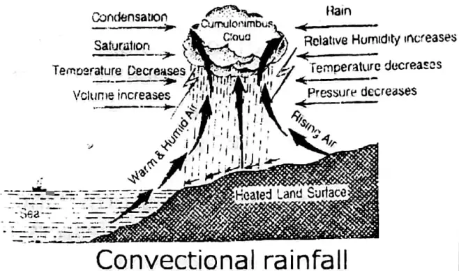
Question 21. Convectional rainfall.
Answer: When the land is intensely heated, the hot and moist air rises up vertically as convection currents. As the air rises up, it expands and cools and condensation takes place, resulting in the formation of cumulus clouds. The result is that torrential rainfall occurs. This type of rain occurs in the equatorial region.
Question 22. Roaring Forties. Convectional rainfall
Answer: In the southern hemisphere landmasses are less than that in the Northern hemisphere. The westerlies blowing near 40° latitude in the Southern hemisphere are not obstructed by the landmass. Hence, they blow with great velocity and make a roaring sound. Thus in 40° south latitude, the westerlies are known as Roaring Forties.
WBBSE Class 10 Geography Chapter 2 Question Answer
Question 23. Orographic Rainfall.
Answer: This is also known as Relief rain. When the vapour-laden winds come in contact with a high mountain, they move upward and are cooled, resulting in rain. This is known as Relief or Orographic rain. In monsoonal lands, this occurs in the summer season. There is no fixed time for this type of rainfall.

Question 24. Isotherm.
Answer: Temperature decreases at the rate of 1°F for every 300 ft ascent above sea level. Thus, the temperature of every place is not the same. Thus, the line joining the places of same temperature is known as an ‘Isotherm’.
Question 25. Atmosphere.
Answer: The atmosphere is the layer of air surrounding the earth. It is held to the earth by gravitational force. It extends to a height of 300 km. It is composed of various gases (Oxygen, Nitrogen, etc.). At sea level, the air is densest and becomes thinner according to ascent.
Question 26. Planetary winds.
Answer: These are permanent winds blowing from high-pressure areas to low-pressure areas.
There are three kinds of winds:
1. Easterlies or Trade winds,
2. Westerlies or Anti-trade winds and
3. Polar winds.
Question 27. Cyclonic rain.
Answer: When the warm moist air current and cold air current approach each other from opposite directions, the warm current being lighter go up and the cold air current blows below along the line of the frontal zone. In the process of ascent, the pressure decreases and the air expands, cools and condensation takes place. Thus, heavy clouds are formed and rain falls. It is associated with cyclones and is known as cyclonic rain; it mainly occurs in the temperate zone.
Question 28. Doldrums.
Answer: All along the equator and between 5° North and 5° South of the equator, allow pressure belt exists.
WBBSE Class 10 Geography Chapter 2 Question Answer
This is due to:
1. The vertical rays of the sun throughout, intense heat is caused. The hot air rises upwards as convection currents expand,
2. Presence of a large amount of water vapour makes the air lighter and,
3. Rotational force of the earth throws the air from the surface to make the pressure light. The movement of air is not horizontal but vertical, so these ascending air are called air currents with very little winds or horizontal movement of air. Thus the region is known also as the Belt of calm or Doldrums.
Question 29. Rain-shadow area.
Answer: After shedding orographic rain on the windward side of a mountain, the dry, cold wind overcomes the mountain and blows down the leeward side (i.e., the opposite slope of the windward side). There is very little moisture left in the air as most has been shed on the windward side.
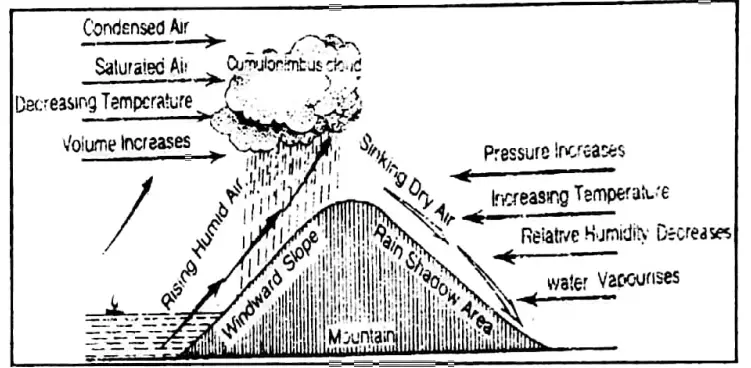
Moreover, as the wind descends, the temperature of the air rises and so does its moisture-holding capacity. This results in very little of rainfall on the leeward slope, which is thus known as the ‘rain-shadow area’.
Example: The eastern slopes of the Western Ghats, i.e., the interior part of the Deccan Bissau e receive very little of rainfall is known as a rain-shadow area of India.
Question 30. What do you mean by river capture or river piracy?
Answer: River capture is a landform feature developed by a river on its mountain course in which a turbulent river captures the course of another weak river.
It, sometimes, happens on the mountainous course that a river increases its headward erosion and then breaks down the water partings and then captures the weaker river on the other side of the watershed. This action of a river is known as River capture or River piracy.
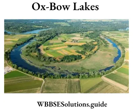
Question 31. What is oxbow lake?
Answer: Ox-bow lake is a lake-like water body in the shape of an ox-bow, developed by a river on its lower course. It, sometimes, develops where meander takes the shape of the letter ‘S’. The two bends of the S-like meander tend to approach each other by side-cutting. A swift current then cuts through the neck and tends to flow rightly straight. The bend is then left there without flow of running water as an ox-bow lake.
WBBSE Class 10 Geography Chapter 2 Question Answer
Question 32. What is a snowline?
Answer: A snowline is an imaginary line on which perpetual snow exists. It is a line on a mountain or hill slope which presents the lower limit of perpetual snow. It may be defined as a line above which the snow does not melt even in summer.
The height of snowlines ranges from sea level around the poles to 5,500 meters or more on mountains of east Africa, near the equator.
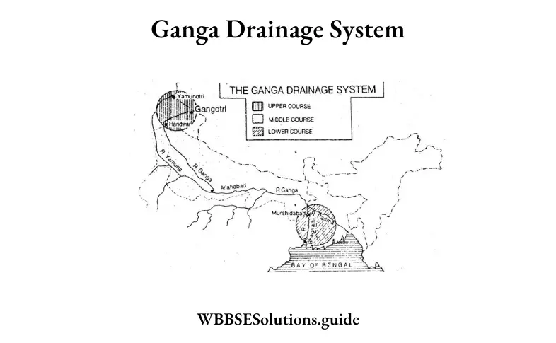
Question 33. Why is the Ganga called ‘an ‘ideal river’?
Answer: The Ganga is a typical example of an ideal river. Throughout the entire course, the Ganga presents the distinct characteristic features of the upper course (as on the Himalayas mountains), the middle course (as on the northern plains) and the lower course (as on the deltas) of an ideal river and that is why the Ganga is called an ideal river.
Question 34. What is Iceberg?
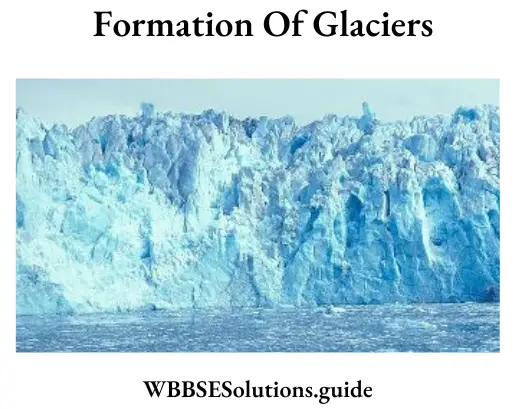
Answer: A block of ice which remains floating on the ocean water is known as an iceberg.
It forms when a glacier enters the sea, the ice is buoyed up by the water and a portion of the glacier is easily broken off and floats away. An iceberg is irregular in shape.
Icebergs are found near the Newfoundland coast which comes from the drift by the Labrador current.
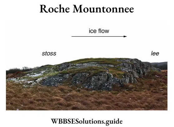
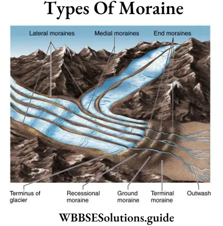
Question 35. What is moraine?
Answer: Moraines are fragments of rock materials, consisting of sand, clay, gravel and boulder brought down with the movement of a glacier. They are of several types, such as, lateral moraines, medial moraines, ground moraines, terminal moraines, recessional moraines, etc.
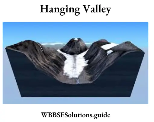
Question 36. How are hanging valleys formed?
Answer: A hanging valley is formed by a tributary glacier. The main glacier forms a much deeper valley than a tributary glacier. After the ice has melted, the tributary valley is left at a higher level than the main valley. Such valleys appear hanging above the main valley and are called hanging valleys.
Question 37. Why do temperatures over land and water surface differ?
Answer: The temperatures over land and water surface differ because land surface gets heated rapidly and cooled rapidly as rocks and soils of the land surface are not good conductors of heat. Oceans/Seas get heated slowly and cooled slowly as water is a good conductor of heat.
WBBSE Class 10 Geography Chapter 2 Question Answer
Question 38. Snow melts more quickly on the south-facing slopes of the Himalayas than on the north-facing slopes – why?
Answer: Areas of steep slopes also show thermal contrast due to the aspect of the slope. Thus in the Himalayas, the south-facing sunny slopes are warmer than the north-facing shady slopes due to which snow melts more quickly on the south-facing slopes of the Himalayas than on the north-facing slopes.
Question 39. Where and why are the trade winds unable to cause rainfall?
Answer: Trade winds are unable to cause rainfall on the eastern margins of the continents because after crossing the continents from east to west they become dry. The western margins of the continents in the tropical zone are deserts like Sahara, Atacama, Kalahari and the western Australian desert because they blow from land to sea.
West Bengal Board Class 10 Geography Chapter 2 Atmosphere 3 Marks Questions And Answers:
Question 1. Briefly explain any three factors to identify the Mediterranean climate in the Temperature-Rainfall graph.
Answer: Three factors to identify the Mediterranean climate in the Temperature-Rainfall graph:
1. Average annual temp: 13°-18°C.
The annual range of temp: is 6° – 16°C. Average
summer temp: 14°-22°C.
Average winter temp: 10°-14°C.
2. Average annual rainfall:35-75 cm.
3. Identification of hemisphere: If the temperature is higher from May to August, the station belongs to the northern hemisphere. If the temperature is higher from November to February, the station belongs to the southern hemisphere.
Question 2. Why does temperature decrease with the increase in altitude in the Troposphere?
Answer: Atmospheric temperature decreases with an increase in altitude for the following reasons:
1. Insolation first heats up the earth’s surface. This heat is radiated into the atmosphere, gradually heating the layers from bottom to top.
2. The upper layers of the atmosphere are less dense and can rapidly radiate out heat and get cooled.
3. Pressure is less in the upper levels of the air, hence their heat absorbing capacity is also less.
Question 3. Discuss the differences between sea breeze and land breeze.
Answer: Differences between sea breeze and land breeze:
| Sea Breeze |
Land Breeze |
| 1. It blows during the daytime. |
1. It blows during the nighttime. |
| 2. It blows from the sea towards the land. |
2. It blows from the land towards the sea. |
| 3. It happens due to unequal heating of land and sea. |
3. It happens due to unequal rates of radiating heat by land and sea. |
Question 4. Why does the sky appear blue?
Answer: The decrease in temperature in the lower atmosphere occurs because it cannot absorb all the incoming light equally. It tends to allow red colours (wavelengths), and this is the reason why the sky appears blue. Again, heat energy from the sun reaches the earth’s surface as short-wave radiation
which does not heat the air through which it passes. Only about 47% of solar energy reaches the earth’s surface, and 17% of it is reflected back into the atmosphere from snow and water surfaces.
Thus only about one-third (34%) of the total energy entering the atmosphere actually warms the earth’s surface. This heat is passed back into the atmosphere from the earth’s surface as long-wave radiation heating the lower atmosphere.
Question 5. Describe the role of water vapour in the weather processes.
Answer:
Water Vapour: Water vapour is the result of evaporation from water bodies on the earth. Water vapour represents about 2 per cent of the air by volume. The presence of water vapour in the atmosphere is of primary importance in weather phenomena.
1. It reduces the amount of insolation reaching the earth’s surface by absorption.
2. It acts like an insulating blanket by preserving the earth’s radiation. It allows the earth to become neither too cold nor too hot.
Class 10 Geography Chapter 2 Notes WBBSE
3. Water vapour is the basic cause of all condensation and precipitation.
4. The presence of most of the water vapour in this layer is responsible for condensation, clouds and precipitation.
5. Dust particles give rise to fog, clouds, smog, etc. in this layer.
6. Convection currents are confined to this layer for the heating and cooling of the atmosphere.
7. The air is unstable in this zone and gives rise to atmospheric disturbances like cyclones.
Question 6. What is the significance of dust particles in the atmosphere?
Answer:
Significance of Dust particles in the Atmosphere: The sources of these dust particles include dry deserts, lime beds, beaches, dry river beds, volcanic eruptions and meteors.
But particles are important due to the following reasons:
1. These play an important part in the heating and cooling of the atmosphere.
2. These affect insolation by the processes of scattering and absorbing sun rays.
3. The dust particles serve as hygroscopic nuclei for the condensation of water vapour.
4. These are responsible or the formation of clouds, sunset, fog and smog (smoke + fog).
5. It affects the visibility of the atmosphere.
Question 7. Distinguish between mist and fog. Why is visibility so poor in smog?
Answer: Mist and fog are not merely low clouds. Fog forms by cooling of rising air. Mist is the result of air of high humidity (80%) being cooled by passing over cooler ground. The particles of water in the mist are smaller and fewer than those in fog. So visibility is lesser in fog than in mist and it is the least in smog, i.e., smoke mixed with fog.
Question 8. How is air cooled?
Answer: Air is cooled in two main ways
1. By being made to rise:
(1) A wind may move up a mountain.
(2) Hot air may rise by convection.
(3) Warm air may rise over cold air.
2. By passing over a cold surface:
(1) A warm air blowing over a cold ocean current.
(2) A warm air blowing over a cold land surface.
Most of the world’s rain results from the first type of cooling and mist and fog from the second type of cooling.
Question 9. State the favourable conditions for the formation of dew.
Answer: Following conditions are favourable for the formation of dew:
1. Long Nights: Long nights give sufficient time for cooling the earth’s surface and the air touching it. This results in a fall of temperature below the dew point and dew is formed.
2. Clear Sky: Clouds obstruct the incoming and outgoing heat radiations. Clear sky permits sufficient heating and large-scale evaporation during the day. Condensation is caused by cooling at night and dew is formed.
3. Calm Air: If the air is calm, it will remain in contact with the earth’s surface for a long time and cool down to the dew point and dew will be formed.
4. High Relative Humidity: High relative humidity is essential for the formation of dew. Where the humidity is low, dew is not formed even if the temperature falls below the dew point.
Class 10 Geography Chapter 2 Notes WBBSE
5. Dew Point should be higher than Freezing Point: If the dew point falls below the freezing point, we will have frost in place of dew.
Question 10. State the factors affecting relative humidity.
Answer:
Factors Affecting Relative Humidity: Relative humidity depends upon the following two factors:
1. Amount of Water Vapour: If the amount of water vapour in the air increases due to evaporation, the relative humidity increases.
2. Temperature of the Air: Relative humidity increases with the fall of temperature but it decreases when the temperature rises. The relative humidity of saturated air is 100%. A given sample of air can become saturated without any addition of water vapour provided its temperature falls to the required extent. On the other hand, a saturated sample of air can become unsaturated if its temperature rises.
Absolute humidity has no relation with temperature. Suppose one cubic metre of air has 5 grams of water vapour at 10°C temperature. If the temperature of the air is increased, the amount of water vapour will remain the same, provided water vapour from outside is not allowed to enter the air. However, the water vapour holding capacity of the air is increased. In other words, the relative humidity will change but absolute humidity will remain unchanged. This thing becomes clear from the table given below.
| Temperature (°C) |
Absolute Humidity (Amount of water vapours present)(gm) |
(The maximum amount of water vapour the air can hold) (gm) |
(Relative Humidity (%) column (1)/ column (2) xl00) |
| 5 |
7 |
7 |
7/7 x 100 = 100.0% |
| 10 |
7 |
9 |
7/9 x 100 = 77.8% |
| 15 |
7 |
14 |
7/14 x 100 = 50.0% |
| 20 |
7 |
20 |
7/20 x 100 = 35.0% |
| 25 |
7 |
28 |
7/28 x 100 = 25.0% |
In other words, relative humidity decreases with the rise in temperature but the absolute humidity remains unchanged, or in other words, the temperature is inversely proportional to relative humidity.
Question 11. Write the importance of relative humidity.
Answer:
The Importance of Relative Humidity: Relative humidity is very important in our daily life. Some important points have been mentioned here:
1. Health: People who live in areas which have high relative humidity do not enjoy good health. Even very low relative humidity is not conducive to health as.it increases irritation and produces cracks on human skin. It has been found that a relative humidity of 60% is most suitable for human health. The study of relative humidity is important because it affects the capacity of human beings for work.
2. Forecasting of Rain: It is possible to find out the possibility of rainfall with the help of relative humidity. In fact, the relative humidity rises before rainfall takes place. Meteorologists are able to make forecasts of weather with the help of relative humidity data.
3. Agricultural Operations: It is possible to calculate the rate of evaporation with the help of relative humidity because the humidity is inversely proportional to evaporation. Evaporation has a great effect on the growth of agricultural crops, the health of animals, etc. Hence knowledge of relative humidity is essential to agricultural operations.
4. Building Material: It is necessary to take into account the relative humidity before constructing buildings. Many types of materials begin to ferment in high humidity. When the relative humidity is very low the plasters develop cracks. Building material is selected taking into consideration the relative humidity of the place.
Class 10 Geography Chapter 2 Notes WBBSE
Question 12. State the characteristics of trade winds.
Answer: The trade winds have the following characteristic features:
1. These winds blow from the north to the south in the Northern Hemisphere and from the south to the north in the Southern Hemisphere. But the Coriolis effect and Ferrel’s law explain how these winds are deflected to the right in the Northern Hemisphere and to the left in the Southern Hemisphere. Thus, they flow as the north-eastern trades in the Northern Hemisphere and the south-eastern trades in the Southern Hemisphere. That is why they are known as ‘Easterlies’ also.
2. The trade winds travel from about 30°N and S towards the equator and gradually become hot and dry. As such they do not cause much rainfall. But when they cross ocean water and reach the land, they cause heavy rainfall on the eastern margins of the continents while their western margins remain practically dry.
3. On the eastern margins of the oceans, the trade winds come into contact with cool ocean currents and do not cause much rainfall there.
4. Near the equator, the two trade winds clash with each other and on the line of convergence, they rise and cause heavy rainfall.
5. The trade winds follow a specific path with a speed of 15 to 25 km per hour. The speed is more in winter than in summer.
6. They are converted into monsoon winds in the Indian Ocean.
Question 13. State the characteristics of westerlies.
Answer: The westerlies have the following characteristics:
1. Under the influence of Coriolis force, they blow from southwest to north-east in the Northern Hemisphere and northwest to south-east in the Southern Hemisphere. They are called westerlies because they blow from the western side in both hemispheres.
2. Since they blow from warm areas to cold areas, they cause considerable rainfall, especially on the western margins of the continents.
3. Their flow is irregular and uncertain in temperate lands due to the occurrence of cyclones and anticyclones there.
4. Their westerly flow is obstructed due to the presence of vast land masses of irregular relief in the northern hemisphere.
5. Due to the presence of a vast expanse of oceans in the Southern Hemisphere, the westerlies are much more stronger and more constant in direction. The westerlies are best developed between 40° and 65° south latitudes. Here they are known as Brave West Winds. According to the sound created by westerlies, these latitudes are often called Roaring Forties, Furious Fifties and Shrieking Sixties, which are dreaded terms for navigators.
6. The poleward boundary of the westerlies is highly fluctuating. There are many seasonal and short-term fluctuations.
Question 14. State the characteristics of polar winds.
Answer: Their main characteristics are as follows:
1. They flow from the northeast to SW direction in the northern hemisphere and from the South-east to North-west direction in the southern hemisphere under the influence of Coriolis force.
2. Since they originate from the poles, they are extremely cold winds.
3. They flow from cold areas to comparatively warm areas and do not cause much rainfall. Their capacity to absorb moisture is also very little due to low temperatures.
4. These winds give birth to cyclones when they come in contact with the westerlies. This brings about frequent changes in the weather and heavy rainfall occurs.
Question 15. What are the reasons for prevailing Low pressure at the equator?
Answer: Low pressure prevails there due to the following three reasons:
1. Due to intense heating, air gets warm and rises over the equatorial region and producing the equatorial low-pressure belt.
2. There is high water vapour content in the air which reduces the density of the air. Reduction in density results in lowering the pressure. It is worth noting that the density of moist air is always less than that of dry air.
3. Earth’s rate of rotation is maximum at the equator. This results in maximum centrifugal force at the equator which pushes the air away from the earth’s surface and causes low-pressure conditions.
Question 16. State the favourable conditions for inversion of temperature.
Answer: Following conditions favour inversion of temperature:
1. Long Nights: Insolation is received during the daytime and it is radiated during the night. The earth’s surface cools down at night due to radiation. The air of the lower layer touching the earth’s surface is sufficiently cooled while the air of the upper layer is still warm. Thus, long nights are helpful for the inversion of temperature.
2. Clear Sky: Clear sky is essential for the reflection of heat radiations by the earth’s surface thereby cooling it. Clouds obstruct this reflection and hamper the occurrence of inversion of temperature.
3. Stable Weather: Continuous radiation of heat is possible in stable weather. This condition leads to temperature inversion. Change in weather disturbs the temperature inversion.
4. Dry Air: Moist air has a greater capacity to absorb heat radiation and obstructs temperature inversion. But dry air does not absorb much radiation and promotes temperature inversion.
5. Ice Cover: Areas covered with ice reflect most of the heat radiation and the layer of air touching it becomes cold while the upper air layer remains warm. This leads to temperature inversion.
6. Air Drainage: During long winter nights, the air on higher slopes cools down quickly and becomes dense. It moves down the slope and settles down on the valley bottom by pushing up the comparatively warmer air. Sometimes, the temperature of the air at the valley bottom falls below the freezing point, whereas the air at higher altitudes remains comparatively warm. This is known as ‘Air Drainage Temperature Inversion’.
Question 17. Give three differences between Temperature & Isolation.
Answer:
| Insolation |
Temperature |
| 1. Insolation is heat energy which makes things hotter. |
1. Temperature measures the intensity of heat, i.e., the degree of hotness. |
| 2. Insolation is measured in calories. |
2. Temperature is measured in degrees (Celsius or Fahrenheit). |
| 3. Insolation is the cause. |
3. Temperature is the effect. |
Question 18. What are the harmful effects of ultraviolet rays?
Answer: Harmful Effects of Ultraviolet Radiations:
1. Ultraviolet radiations reaching the earth from the sun are harmful to all life forms on the earth (including man, plants and animals).
2. They cause skin cancer, particularly in fair-skinned people.
3. They cause cataracts and blindness among humans. and animals.
4. They reduce our immunity to diseases, thus, impairing the body’s resistance.
5. They adversely affect crop production and cause food shortages.
6. Rainfall cycle or hydrological cycle is also disturbed by ultraviolet rays.
7. On reaching the earth’s surface the ultraviolet rays cause ecological disturbances.
8. Ozone can affect the earth’s climate by adding to the greenhouse effect.
Question 19. State the characteristics of Ilsotherms.
Answer: Characteristics of Ilsotherms:
1. isotherms run almost parallel to latitudes because the same amount of insolation is received and the same temperature is experienced by almost all points located on a particular latitude.
2. Due to differential heating of land and water, temperature above the oceans and land masses varies even on the same latitude. Isotherms, therefore, bend slightly white crossing from landmass to oceans and vice-versa.
3. There is more water area in the southern hemisphere resulting in uniform temperature distribution. So there are less bends in the isotherms and their east-west trend is more clear in the southern hemisphere as compared to the northern hemisphere.
4. Distance between isotherms indicates the rate of change of temperature. Close spacing of isotherms indicates a rapid change in temperature and wide spacing means slow to change.
5. Temperature is always high in the tropics and isotherms of high value are located there. Very low temperature is experienced by polar areas and isotherms of low value are found there.
Question 20. State the effects of global warming.
Answer: Effects of Global Warming are:
1. Global temperature is likely to rise by 2°C to 5°C during the next century.
2. Due to the rise in temperature by 2°C to 5°C, there is a chance of the melting of ice caps on Earth’s poles. This melting of ice will result in the rise of the sea level. Large stretches of low-lying areas will submerge and many island countries will face deep encroachment by seawater. Some may disappear altogether.
3. As the increase in temperature will be uniform all over the surface of the world, there will be serious climatic changes. This will bring various changes in wind and rain patterns.
4. Higher temperatures will cause a rise in transpiration, which in turn, will affect the groundwater table.
5. As the climatic belts shift from the equator towards the pole, the vegetation would also shifts away from the equator.
6. Insects and pests will increase in warmer climatic conditions. Thus, pathogenic diseases will multiply.
Question 21. State two scales used to measure temperature. State their relation also.
Answer: Thermometers are used to measure temperature. There are two scales used to measure temperature — the Centigrade Scale and the Fahrenheit scale.
The centigrade scale has 100 divisions while the Fahrenheit scale has 180 divisions. One scale can be converted to the other with the help of the conversion formula:
Question 22. Discuss the different ranges of temperature.
Answer:
Ranges of Temperature: The difference between the maximum and the minimum temperatures on any one day is termed as the Diurnal Range of Temperature. Starting from sunrise, the temperature shows a gradual increase until mid-day and then remains fairly constant for a couple of hours before beginning to fall again.
Though the angle of incidence is maximum around noon, the maximum temperature is re- corded at about 3 p.m. This is because the heating of the atmosphere takes place from below and consequently there is a time lag.
The Mean Monthly Temperature is the average of mean temperatures of all the days in the month. In the Climate Data, the mean monthly temperature is calculated on the basis of average values of the mean temperature of the days for each month. The Mean Annual Range of Temperature is the seasonal difference in temperature or the difference between the mean temperature of the hottest month and the mean temperature of the coldest month.
Question 23. State three factors determining rainfall.
Answer: The same factors that determine climate also determine the amount of rainfall because there is a close relationship between moisture in the atmosphere, pressure and temperature. However, three chief factors are:
1. Land-sea contrast: Because water vapour rises from oceans, sea coasts receive more rainfall than the interior of the continents.
2. Direction of winds: Prevailing winds blowing from ocean to land bring more rainfall than winds blowing from the land.
3. Presence of mountains: Mountains force the winds to shed moisture on the windward side and the leeward side generally remains dry.
Question 24. Define absolute humidity and relative humidity.
Answer:
Absolute humidity: The total amount of water vapour in a definite volume of air at a particular temperature is called absolute humidity.
Relative humidity: The ratio between the absolute humidity and the amount of moisture that the same volume of air can hold at that temperature is called relative humidity.
Question 25. Differentiate between Absolute Humidity and Relative Humidity.
Answer:
| Absolute Humidity |
Relative Humidity |
| 1. It is the measure of the weight of water vapour that is present in a given volume of air and is expressed in grams. |
1. It is simply the ratio between the amount of water vapour in air at a given temperature and the maximum amount of water vapour that the air could hold at that temperature and is expressed as a percentage. |
| 2. A.H. determines the amount of precipitation. |
2. But R.H. indicates whether there will be any precipitation or not. |
| 3. It may not change throughout the day. |
3. It varies with the daily temperature. |
Question 26. Differentiate between the troposphere and the stratosphere.
Answer:
| Troposphere |
Stratosphere |
| 1. It is the lowest layer of the atmosphere. |
1. It is the second layer of the atmosphere above the earth. |
| 2. Its height varies from 8 km at the poles to 20 km at the equator. |
2. Its height varies from 16 km at the equator and 72 km at the poles. |
| 3. In this layer the temperature decreases at the rate of 1°C per 165 metres. |
3. Temperature is very low and fairly constant in this layer. |
| 4. It is a zone of convectional currents. |
4. It is the non-convective zone of the atmosphere. |
| 5. Most of the water vapour and dust particles are found in this layer. |
5. Cloud, dust particles are practically absent in this layer. |
| 6. Atmospheric disturbances are confined within this zone. |
6. This zone is free from atmospheric disturbances. |
Question 27. Write in short about the temperature belts of the world.
Answer: The earth is divided into 5 temperature zones.
They are:
1. One Torrid zone
2. Two Temperate zones and
3. Two Frigid zones.
1. One Torrid Zone: The 27° celsius isotherm lines on both sides of the equator determine the boundaries of the torrid zone. This zone receives maximum sunshine around the year,
2. Two Temperate Zones: The areas between the 27-celsius isotherm line and the 0-celsius isotherm line on both hemispheres constitute the two temperate zones.
3. Two Frigid Zones: The areas covering from 0 isothermal lines to the poles on both the hemisphere comprise the two frigid zones.
Question 28. Differentiate between weather and climate
Answer:
| Weather |
Climate |
| 1. Weather stands for actual atmospheric conditions for a short period-a day or two. |
1. Climate is the aggregate of atmospheric conditions for a longer period. |
| 2. The weather change from day to day and can not be generalized. |
2. The climate is ever-lasting and fixed, it does not change so frequently. |
| 3. Weather is actually present at a place It is what you get. |
3. Climate is what you expect. It is arrived at by climatic means or average. |
| 4. Every type of weather can occur at one place. |
4. A particular place can not have all types of climate. |
| 5. Weather refers to a particular place. |
5. But climate refers to a particular area. |
| 6. Weather deals with the individual elements of weather. |
6. But climate deals with the combination of all the elements of weather. |
Question 29. What do you know about the composition of the atmosphere?
Answer: The atmosphere is mainly composed of three elements:
1. Gases,
2. Water vapour and
3. Dust particles.
1. Gases: Nitrogen and oxygen are the two major gases found in the atmosphere. About 99% of the atmosphere consists of these two gases. Nitrogen occupies 78% and oxygen occupies nearly 21% of the atmosphere by volume.
The remaining 1% consists of a number of gases like Argon, Carbon dioxide, Neon, Helium, Krypton, Hydrogen, Xenon, etc.
2. Water Vapour: The amount of water vapour varies from place to place and from time to time.
3. Dust particles: Air also contains tiny dust particles which are mainly found in the lower atmosphere. They are rarefied in the higher level.
Question 30. Explain the condition for the formation of rainfall.
Answer: The rains are drops of water which fall down on the ground from the clouds.
Formation of Rainfall: The main cause of rainfall is the cooling of saturated water. The mechanism involved in it passes through a number of stages:
1. Air should have plenty of water vapour,
2. Air should be saturated with moisture,
3. Air should get cooled or get the chance to come in contact with the cold air for condensation and
4. Condensation of water vapour makes droplets.
They together form clouds. Thus clouds are made of water droplets or ice particles. These cloud (particles) droplets coalesce (merge) to form raindrops. When these raindrops become heavy, air cannot hold them, and due to the gravitational pull of the earth, they fall on the ground in the form of raindrops.
Question 31. Westerlies cause heavy rainfall. Why?
Answer: Westerlies come from a hot place. So, they have a good capacity to hold water. While coming to a place they blow over the water bodies and pick up lots of moisture. As they arrive in a cooler region, their water-holding capacity shrinks giving rise to heavy rainfall. Hence, westerlies cause heavy rainfall.
Question 32. State the importance of water vapour in the atmosphere.
Answer: Water vapour has immense importance due to:
1. Presence of water vapour in the air causes clouds to form and rain to occur.
2. It is also the source of all forms of precipitation.
3. It absorbs heat and keeps the surrounding air warm.
4. It has an important role in determining the climate of a region.
Question 33. What do you know about Tropopause, Stratopause and Mesopause?
Answer:
Tropopause: The upper limit of the tropopause is called tropopause and at this boundary, the fall in temperature with increasing height stops.
Stratopause: The upper limit of the stratosphere is called stratopause and it is about 50 km above the ground.
Mesopause: The upper. limit of the mesosphere is called mesopause. The temperature falls to about 100 C at this mesopause.
Question 34. State the conditions necessary for precipitation.
Answer: Following conditions are necessary for precipitation:
1. There should be plenty of water vapour in the atmosphere in the adjoining areas. This is possible only when there is great evaporation in the neighbouring seas or oceans.
2. The oceanic winds should blow towards the land to transfer vapour-laden air from the ocean to the land, where the rainfall is to occur.
3. The process which can induce the vapour-laden air masses to rise to higher altitudes for cooling and condensation.
Question 35. Mention the different characteristics of the troposphere.
Answer: Of all the layers of the atmosphere, the troposphere is the most important in climatology due to its following characteristics :
1. All the weather-making processes are confined to this layer.
2. Great contrasts in climate and weather are observed in different areas due to changes in temperature in this layer.
3. The presence of most of the water vapour in this layer is responsible for the condensation of clouds and precipitation.
4. Dust particles give rise to fog, clouds, smog, etc. in this layer.
5. Convectional currents are confined to this layer for the heating and cooling of the atmosphere.
6. The air is unstable in this zone and gives rise to atmospheric disturbances like storms, and cyclones.
Question 36. Write the causes for the inversion of temperature.
Answer: Generally there is a decrease in temperature as we ascend upward above sea level, but sometimes temperature increases as we ascend upward. This is known as “Inversion of temperature” or “Lapse rate of temperature”. The causes for the inversion are :
1. When in the calm and cloudless sky in the mid-latitude area, the radiation is swift or when a warm air current flows on a cold surface area of the earth.
2. On the upper slope of the mountain when radiation is rapid and the cold wind resembles the cold water or blows ina the valley due to gravitation,
Question 37. State the characteristics of Cyclones and anticyclones.
Answer:
Cyclone:
1. Cyclone has low pressure at the centre.
2. It blows towards the centre of low pressure from all sides.
3. In the Northern hemisphere it moves anti-clockwise, in the Southern hemisphere it moves clockwise.
4. On reaching the centre of low pressure it moves upwards.
5. Rainfall occurs at the centre of the cyclone.
Anti-cyclone:
1. Anti-cyclone has higher pressure at the centre.
2. It blows in all directions from the centre.
3. In the Northern hemisphere it blows clockwise in the Southern hemisphere it blows anti-clockwise.
4. It moves downwards.
5. It does not produce rain, rather it brings fair weather.
Question 38. Distinguish between the land breeze and sea breeze.
Answer:
| Basis |
Land Breeze |
Sea Breeze |
| 1. Definition |
A cool periodic wind blows from land to ocean in coasts. |
A cool periodic wind blows from the ocean to land in the coasts. |
| 2. Cause |
A low-pressure situation on the ocean. |
A low-pressure situation on land. |
| 3. Time |
Night, after sunrise it disappears. |
Day, after sunset it disappears. |
| 4. Nature |
Weak. |
Strong. |
| 5. Expanse |
Limited in the sea. |
Reaches the interior of the continent. |
| 6. Effect |
Clear sky, weak anti-cyclones. |
Cloudiness and weak cyclones. |
Question 39. Differentiate between Trade winds and Westerlies.
Answer:
| Trade winds |
Westerlies |
| 1. The winds blowing in both the hemispheres From the sub-tropical high-pressure belts towards the equatorial low-pressure belts are called Trade winds. |
1. The winds blowing in both the hemisphere from sub-tropical high-pressure belts towards subpolar low-pressure belts are called Westerlies. |
| 2. The direction of these winds in the Northern hemisphere remains from the northeast towards the southwest and in the Southern hemisphere from the southeast towards the northwest. Therefore, they bring rainfall at the Eastern coast of the continents through the Western coast remains almost dry. |
2. The direction of these winds in the Northern hemisphere remains from southwest towards the northwest and in the Southern hemisphere from the northwest towards the southeast. Therefore, they bring rainfall at the western coast of continents though the eastern coast remains dry. |
| 3. They show consistency in blowing. Thus these winds were helpful as backing winds to sailing ships in past. |
3. These winds blow inconsistently. Sometimes they blow with low strength and sometimes with greater strength, especially in the winter season. |
Question 40. Describe the mechanisms of any two types of rainfall.
Answer:
1. Orographic or relief rainfall: Orographic rainfall occurs when moisture-laden winds are cooled due to ascent along a mountain slope or a plateau barrier. As it rises, the moist wind comes in contact with the cool upper atmosphere. As a result, the moist air condenses and rainfall occurs. When the winds go to the opposite side of the hills, plateaus, etc.
They are left with little water vapour. Therefore, the rainfall is much less on the opposite side. The slope which gets maximum rainfall is referred to as the windward side and the side which gets little rain is called the leeward side or rain-shadow region. Since this type of rainfall is caused by the relief of the land, it is known as relief rainfall.
2. Cyclonic rainfall: This type of rainfall is caused by the convergence of warm and cold air masses along a front. It occurs when a moisture-laden warm air current and cold air current approach each other from opposite directions. The moist air climbs up the cold air along the meeting line called a front. The air expands, cools and finally, rain and cyclones occur.
Question 41. Why are cloud-free nights colder than clouded nights?
Answer:
Cloud-free nights are colder than clouded nights: During the day, the earth is heated by the sun. If the skies are clear, more heat reaches the earth’s surface. This leads to warmer temperatures.
However, if skies are cloudy, some of the sun’s rays are reflected off the cloud droplets back into space. Therefore, less of the sun’s energy is able to reach the earth’s surface, which causes the earth to heat up more slowly. This leads to cooler temperatures.
When forecasting daytime temperatures, if cloudy skies are expected, forecast lower temperatures than you would predict if clear skies were expected. At night cloud cover has the opposite effect. If skies are clear, the heat emitted from the earth’s surface freely escapes into space, resulting in colder temperatures.
However, if clouds are present, some of the heat emitted from the earth’s surface is trapped by the clouds and re-emitted back towards the earth. As a result, temperatures decrease more slowly than if the skies were clear.
When forecasting nighttime temperatures, if cloudy skies are expected, forecast warmer temperatures than you would predict if clear skies were expected They show consistency in blowing. Thus these winds were helpful as backing winds to sailing ships in past.
Chapter 2 Atmosphere 5 Marks Questions And Answers:
Question 1. Give an account of the atmospheric layers of the Troposphere and Stratosphere.
Answer:
Troposphere: This layer extends up to 16-18 km from the earth’s surface over the equator. It is the layer which is connected with the earth’s surface.
1. All the weather-making processes are confined to this layer.
2. Great contrasts in climate and weather are observed in different areas due to changes of temperature in this layer.
3. The presence of most of the water vapour in this layer is responsible for the condensation of clouds and precipitation.
4. Dust particles give rise to fog, clouds, smog, etc. in this layer.
5. Convectional currents are confined to this layer for the heating and cooling of the atmosphere.
Stratosphere: This layer is found up to a height of 50 km above the Troposphere. There is no formation of clouds in this layer and thus there is no weather. There does not exist any danger of the storm. That is why this layer is ideal for aircraft.
1. It is the second layer of the atmosphere above the earth.
2. Its height varies from 16 km at the equator and 72 km at the poles.
3. Temperature is very low and generally increases in the upper part of the layer.
4. It is the non-convective zone of the atmosphere.
5. Cloud, dust particles are practically absent in this layer.
Question 2. Explain the factors responsible for the formation of equatorial low-pressure belts and polar high-pressure belts.
Answer:
Pressure Belts: The atmosphere is immensely heated due to high temperatures. The landmass is heated through insolation and the air close to the surface is heated through conduction. The heated air moves upwards giving place to low pressure.
Thus, a vacuum is created to fill the gap air from a low-temperature area, i.e., air from a high-pressure region comes. Thus, the winds blow from high-pressure areas to low-pressure areas.
1. Equatorial low-pressure belt: All along the equator and between 5° north and 5° south of the equator, a low-pressure belt exists. This is due to
(1) The vertical rays of the sun throughout, intense heat is caused. The hot air rises upwards as convection currents and expand,
(2) Presence of a large amount of water vapour makes the air lighter and
(3) rotational force of the earth throws the air from the earth’s surface to make the pressure light. The movement of air is not horizontal but vertical these ascending air are called air currents with very little winds or horizontal movement of air. Thus, the region is known also as the Belt of Calm or Doldrums.
2. Polar High-Pressure Belt: Around the North Pole and South Pole high pressure belts are found due to extreme cold, and very little centrifugal force. Here the region is frozen throughout the year and the temperature is always low.
Question 3. Give an account of the occurrence of orographic rainfall with a suitable example and diagram.
Answer:
Orographic or Relief rain: When clouds on their way dash against hills, plateaus, etc., they rise up. Higher up the clouds condense and then rain falls on the slopes of the mountain and the plateaus. When it goes to the other (opposite) side of the hills, plateaus, etc., it is left with little water vapour.

Therefore, the rainfall is much less on the opposite side. This type of rain is called relief rain as it is caused mainly due to the relief of the land. The opposite side of the hill where the rainfall is much less is called the rain shadow area. The Deccan plateau is an example of a rain-shadow region in India. Orographic or Relief rain
Question 4. Explain with sketches the origin and direction of planetary winds of the world.
Answer: There are three types of planetary winds:
1. The Trade winds,
2. The Westerlies,
3. The Polar winds.
1. The Trade winds: Winds that blow from the Sub-tropical high-pressure belts to the Equatorial low-pressure belts are called Trade winds. According to Ferrel’s law, due to Coriolis force, caused by the earth’s rotation, winds deflect to the right in the northern hemisphere and to the left in the southern hemisphere.
Hence, the winds are called northeast trade winds in the northern hemisphere and the southeast trade winds in the southern hemisphere. The velocity of NE trade winds is around 16 km per hour and that of SE trade winds is 22 km per hour (due to fewer landforms and vast oceans).
2. The Westerlies: The winds blowing from the sub-tropical high-pressure belts to the sub-polar low-pressure belts are called Westerlies. As the director of the Westerlies is opposite to that of trade winds, they are also called Anti-trade winds. In the northern hemisphere, they blow from the southwest and in the southern hemisphere, they blow from the North-West.
3. The polar winds: The chilled winds blowing from the polar regions to the subpolar low-pressure regions are called the polar winds. Since their direction is similar to that of Trade winds, they are also called Polar Easterlies or Polar Trade winds. In this region, the deflection of winds is so high that they appear to blow almost from the east.
Question 5. Discuss the major characteristic features of Tropical Monsoon climatic regions.
Answer: The word monsoon is derived from the Arabic word Muslim meaning season. The monsoon wind is a seasonal wing as it is very much associated with rain, it invariably means the rainy season. Characteristics of this climatic region are stated below:
1. The monsoon winds change their direction according to seasons (in summer and in winter).
2. The summer monsoons bring rains as they come from the seas winter, monsoons remain rainless as they generally blow from the land.
3. Summers are hot and wet, and winters are pleasantly warm and almost rainless.
4. The summer temperature ranges between 27°C and 32°C.
5. The winter temperature varies between 13°C and 22°C.
6. The range of temperature between day and night, and between summer and winter is considerably wide; it is about 10°C to 15°C.
7. The rains come in the latter half of summer.
8. The amount of rainfall varies from place to place according to landform features. Generally, this region has an average rainfall between 100 cm and 200 cm.
Question 6. Explain three major factors responsible for temperature variation in the atmosphere.
Answer: Three major factors responsible for temperature variation in the atmosphere are as follows:
1. Latitude: The latitudes exercise the most dominant control over the duration of the sunshine and thereby the length of the day. The higher is the latitude, the lower is the amount of heat received.
2. Altitude: By the normal lapse rate, temperature decreases by 64°C with every 1km rise in altitude. Hence, higher altitude places are colder than lower regions.
3. Distribution of land and water bodies: Heat-absorbing capacities of land and water bodies are not equal. The latent heat capacity of water is more compared to land. Hence, extremes of temperature are noticed on land, while water bodies show a moderate range of temperature.
Question 7. Give an account of the major climate regions of the world with respect to their natural vegetation, temperature, air pressure, rainfall & human activity.
Answer: The following table presents the scheme of the world’s climatic types with their seasonal temperature, air pressure, rainfall, natural vegetation and human activities:
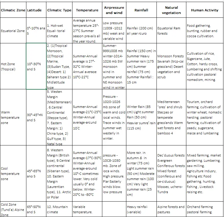
Question 8. State the factor affecting the rate of evaporation.
Answer: The process by which water is transformed from liquid to vapour or gas is known as evaporation. The water vapour suspended in the earth’s atmosphere is the result of evaporation. Approximately 600 calories of energy are required to convert one gram of water vapour without any change in the temperature. This is known as latent heat. The rate of evaporation keeps on os from place to place and from time to time.
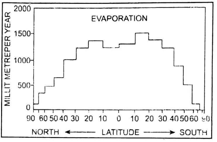
The following factors affect the rate of evaporation:
1. Temperature: An increase in temperature increases the water absorption and retention capacity of air. As such, air with higher temperature is capable of more evaporation as compared to air of lower & temperature. Evaporation in the tropical zone is much higher than in the polar zone because the temperature prevailing in the top Evaporation is higher in summer than in winter due to temperature differences. Similarly, evaporation is higher during the day as compared to night.
(1)Dryness of Air: Dry air has a larger potentiality of absorbing and retaining water vapour as compared to wet air. So evaporation by dry air is larger than that by wet air. It is on account of this reason that evaporation is higher in dry season than in the rainy season.
(2)Clouds: Clouds act as blankets for incoming solar radiation and obstruct evaporation. Thus, a clear sky is essential for evaporation.
(3)Size of the Water Area: The larger the size of the water area, the larger the amount of evaporation.
(4)Movement of Air: The movement of air replaces the saturated layer with the unsat- curated layer which has a greater capacity of absorbing moisture. Hence, the greater the movement of air, the greater is the evaporation.
Question 8. Distinguish between temperate cyclone & tropical cyclone.
Answer:
| Temperate Cyclones |
Tropical Cyclones |
| 1. Temperate cyclones develop in temperate lands. |
1. Tropical cyclones originate and grow in the tropical zone. |
| 2. Temperate cyclones can develop both on land and at sea. |
2. Tropical cyclones mainly originate in the sea and they disappear after crossing over to land. |
| 3. They are more active in the winter season. |
3. They are more active in the summer season. |
| 4. The isobars in a temperate cyclone are elliptical. |
4. The isobars in a tropical cyclone are circular. |
| 5. They are large in size with their diameter varying from 800 to 1600 km. |
5. They have a small size and their diameter varies from 150 to 750 km. |
| 6. Pressure gradient is gentle. |
6. Pressure gradient is steep. |
| 7. Wind velocity is less, say 30-40 km/hour. |
7. Wind velocity is more, about 100 to 200 km/hour, |
| 8. Temperate cyclones move from the west. |
8. Tropical cyclones move from east to west. |
| 9. Rainfall is light but widespread. |
9. There is torrential rainfall which is concentrated over a small area. |
| 10. Rainfall continues for several days. |
10. Rainfall stops after a few hours. |
Question 9. Describe the major temperature belts or heat zones of the world.
Answer:
World’s Heat Zones: We can divide the earth into five zones on the basis of the heat received from the sun; they are one Torrid zone, two Temperate zones (the north and south temperate zones) and two Frigid zones (the north and south frigid zones).
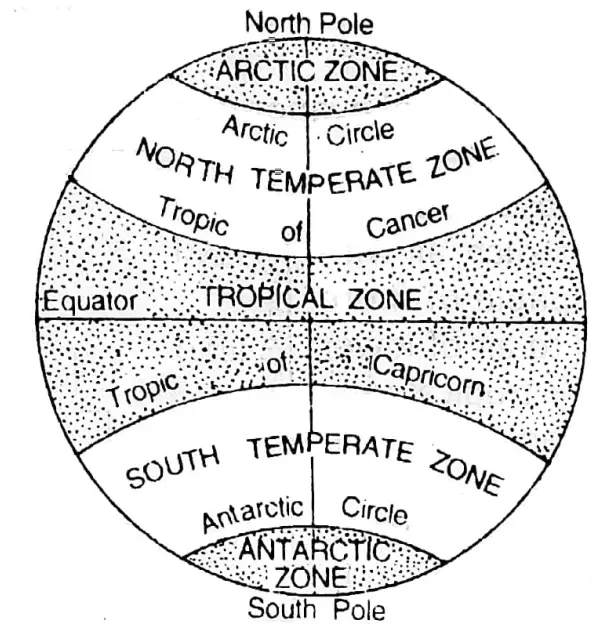
(1)The Torrid or the Hot Zone: The Torrid or the Hot zone lies between the Tropic of Cancer and the Tropic of Capricorn It is the hottest part of the earth. The equator runs through the middle of this zone. The sun shines over this region more or less vertically throughout the year.
(2-3) The Temperate Zones: The North Temperate zone lies between the Arctic Circle and the Tropic of Cancer. The South Temperate zone lies between the Antarctic Circle and the Tropic of Capricorn. This is a zone of moderate climate. The sun is never overhead in this region. The summers are not very hot, nor are the winters very cold. That is why they are known as temperate zones.
(4-5) The Frigid or the cold zones: The North Frigid zone lies between the Arctic Circle and the North Pole. The South Frigid zone lies between the Antarctic Circle and the South Pole. In these zones, the sun- rays are always very slanting so these are the coldest parts of the earth. Summers are very short and cold. Winters are long and extremely cold. Land remains frozen throughout the year.
Question 10. (1)Explain the mechanism of the movement of wind and mention its importance as a controller of weather and climate. (2)Classify wind.
Answer: Mechanism of Movement of wind: Winds do not blow in a straight line. They change their directions while blowing. This is due to the rotational movement of the earth.
In the northern hemisphere, they deflect to the right, while in the southern hemisphere, they deflect to the left. This rule is known as Ferrel’s law. The deflection is the least on the equator, but it goes on increasing towards the poles.
The wind controls the weather and climate of a place to a great extent.
1. Sometimes, it reduces the temperature of a place, and sometimes, it brings moisture (water vapour) from the seas for making rain.
2. A wind from the sea lowers the summer temperature and raises the winter temperature.
3. A wind from the land lowers the winter temperature. The out-blowing cold winds from central Asia cause a cold wave in winter in North China.
4. Distribution of rainfall is controlled by the wind system over the earth. Land winds are dry, on-shore winds are moist and they offer rainfall.
5. Winds bring changes in temperature and rainfall which form together the basis of climate division from place to place.
Classification of Wind: There are different types of wind. They may be classified into the following four major types:
(1)Planetary winds (e.g. the Trade winds, the Westerlies, the Polar winds),
(2)Periodical winds (i-e., the Land Breeze, the Sea © Breeze, the Monsoon, etc.),
(3)Local winds (i.e., the Loo, the Chinook, the Fohn, etc.) and
(4)Sudden or Irregular winds (cyclone and anti-cyclone).
Question 11. What are the effects of global warming?
Answer: Effects of Global warming:
(1)Melting of the caps and glaciers: An increase in the average temperature of the atmosphere affects permanently frozen areas. The lower altitudes will heat up, melting too much snow, thus reducing the length of glaciers.
(2)Increase in sea level: The melting of snow will cause the excess formation of water, which will raise the sea level. In the last century, the sea level was raised by 10-12 cm due to an increase of temperature by 1°C. This will drown coastal areas and islands, hamper the ecosystem, disturb the natural fluvial cycles, change landforms and increase the salinity of rivers.
(3)Change in climate conditions: The amount of precipitation in tropical and hot temperate regions will increase profusely. The northern hemisphere has more land surface, and temperature will increase by 2 or 3 times more than the southern hemisphere. The number of cyclones and thunderstorms will increase. There will be droughts, floods and long summers.
(4) Effects on natural vegetation and agriculture: Many species of coniferous and mangrove trees may get endangered. The crop calender will change. Although the production of corn, sugarcane, jowar, bajra, etc. may increase, the production of wheat, rice, oats, barley, soybean, tobacco, cotton, jute, etc. will decrease. The attack of pests on crops will increase.
(5) Increase in diseases: More numbers of viruses and bacteria will get activated due to heat. Immunity of human beings will get reduced and hence these germs will cause more diseases. Heat strokes and heart attacks will also increase.
(6) Extension of deserts: Destruction of vegetation due to excessive heat will make the soil barren and infertile. This will cause the spreading of deserts extensively.
(7) El-Nino: El-Nino refers to large-scale ocean-atmosphere climatic interaction linked to periodic warming in sea surface temperatures across the central and east-central Equatorial Pacific Ocean. The El-Nino disturbs the global distribution of rain- fall and temperature and also affects the seasons.
(8) Imbalance in earth’s incoming and outgoing solar radiation: The greenhouse gases will arrest excessive heat which will not be released within the day, before the next insolation and keep the atmosphere warm. Hence, there will be a disparity in incoming and outgoing solar radiation.
Question 12. Discuss the factors influencing air pressure.
Answer: Atmospheric pressure varies both vertically and horizontally. The following factors influence the atmospheric pressure –
(1)Altitude: With the increase in height from the sea level, the density of air decreases. So, the weight of air is lower. Thus, from the sea level air pressure lowers by 34 millibars for every 300 m ascent. Adjacent to high mountains air pressure is low so the air is light. E.g.-At the top of Mt. Everest, the air pressure is about 2/3 times less than the sea level.
(2)Temperature: Air temperature has a very close relation with air pressure.
1)When the air temperature decreases air pressure increases When the air temperature falls air becomes cold and dense and hence exerts more pressure. E.g.In the polar regions, excessive cold causes high pressure.
2)When the air temperature increases air pressure decreases: When the air temperature rises the air becomes light and its volume increases hence it exerts less or low pressure. E.g.-In the equatorial region air temperature is high so air pressure is low.
(3)Water Vapour: Water vapour is lighter than air. Water vapour-containing air is lighter than dry air. Hence it exerts high pressure. In the monsoon, season air contains lots of water vapour so it exerts less pressure.
(4)Earth’s rotation: The rotation of the earth and centrifugal force deflect the air. Due to this deflection, the pressure varies. The sub-polar low-pressure belt is due to the rotation of the earth.
Question 13. Explain the relation between pressure and wind.
Answer: Generally, winds blow from regions of high pressure to regions of lower pressure. It is said that winds blow down the barometric slope or pressure gradients. It refers to the rate and direction of change in pressure. Actually, the barometric slope determines the wind direction.
If the difference in pressure between two adjacent regions becomes very high, it is called a steep barometric slope. But if it is low, a weak barometric slope is formed. When the barometric slope on the pressure gradient is steep, the wind blows rapidly when it is weak, the wind becomes weak. So the velocity of wind is determined by the degree of steepness of the barometric slope.
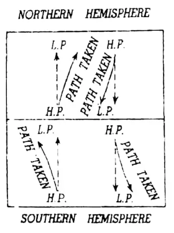
Ferrel’s Law: Winds do not move straight down a pressure gradient. If the earth did not rotate on its axis, winds would follow the direction of the pressure gradient. Earth’s rotation produces the Coriolis force which tends to deflect the winds. The direction of the deflection is stated in Ferrel’s Law A body, moving in the northern hemisphere, will a Sit be deflected to the right and in the southern hemisphere will be deflected to the left”.
Buys Ballot’s Law: Buys Ballo law states: Stand with your back to the wind in the northern hemisphere, the low pressure will be towards your left and the high pressure towards your right, and the reverse applies in the southern hemisphere.
Question 14. State the importance of atmosphere.
Answer:
(1)Insulator: It acts as a shield and protects all living bodies on the earth from the direct rays of the sun and thus prevents the earth from becoming too hot. As a blanket of air, the atmosphere serves as an insulator, maintaining the livable temperatures we experience on earth.
(2)Pressure: Held to the earth by gravitational attraction atmosphere envelops the earth. Although it is not as dense as either land or water, it has weight and exerts pressure. Such phenomena help us to stand, move and walk freely on the earth.
(3)Basic materials of life: The atmosphere sets in a constant turnover of certain basic materials which are vital to the development and maintenance of life on earth.
1)It provides Oxygen a vital gas.
2)It also provides other important gases like Nitrogen (the largest proportion of air), Carbon dioxide (helps in photosynthesis), Ozone (protects the earth from UV rays), etc.
3)It provides water vapour, a vital variable gaseous constituent.
4) Oxygen, CO, and O, influence weather conditions. They absorb small amounts of solar energy and act as temperature regulators. (e) Dust particles present in the atmosphere act as Hygroscopic Nuclei.
(4)Earth’s water cycle: The water cycle of the earth is maintained through the atmosphere.
(5)Other importance:
1) The atmosphere serves as a shield to protect us from showers of meteors.
2) Sound travels by the molecules of the atmosphere. Hence, we can talk and hear.
Question 15. Classify different types of winds with examples.
Answer: Winds are generally classified into four major categories, i.e.,
1. Planetary winds or permanent winds: Permanent planetary winds are the winds blowing uniformly throughout the year. They are the planetary system of winds. They are of 3 types:
(1) The trade winds: The word trade has been derived from the word ‘trader’ which means ‘track’ or ‘regular path’. The winds which blow permanently from a sub-tropical high-pressure belt to equatorial low pressure between 30 N and S attitudes along a definite path along the same direction are called trade winds.
(2) Westerlies: The winds which blow from the high-pressure belt of Tropic of Cancer and Tropic of Capricorn to the low-pressure belt of sub-polar regions of North and South respectively, are known as Westerlies.
(3) Polar winds: The winds which pat from the polar high-pressure belt are called polar winds.
2. Periodic winds: The winds which blow from time to time or in a certain season of the year are called periodic winds. There are of 3 types:
(1)Land breeze: Winds blowing from land to sea at night.
(2)Sea breeze: Winds blowing from sea to land during the day.
(3) Monsoon winds: Winds originated due to differential heating.
3. Local winds: Winds produced due to local temperature or atmospheric variations are called local winds. They occur for short periods of time. Some of them are:
(1)Hot winds: Sirocco, Chinook, Foehn, Santa Ana, etc.
(2)Cold winds: Blizzard, Pampero, Mistral, Bora, etc.
4. Sudden or irregular winds: Due to atmospheric disturbances sometimes there blow irregular winds of great speed called sudden or irregular winds. They are Cyclones, Tornadoes, Hurricanes, Anti-cyclones, etc.
Question 16. Define local wind. Describe some local winds in brief.
Answer: Winds ‘produced due to local temperature or atmospheric variation are called local winds. Some of the important local winds are:-
1. Hot winds:
(1)Sirocco: It is a very hot dry wind of the Sahara desert. It blows from Sahara to the Mediterranean region. It is known as Khamsin in Egypt, Harmattan on the Guinea coast of West Africa and Sirocco in Sicily.
(2)Chinook: Chinook is a warm and dry wind which blows on the leeward slope of the eastern Rockies in the USA and Canada.
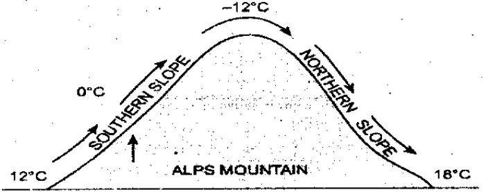
(3)Foehn: Foehn is a warm dry wind on the leeward slope of the northern Alps in Switzerland.
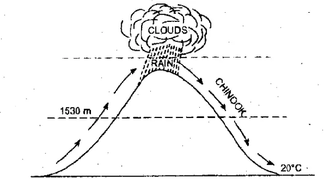
(4)Loo: Loo is a hot wind which blows usually in the afternoon in the plains of northern India during May and June.
(5)Santa Ana: This hot and dry wind is experienced in Southern California where it blows from the Santa Ana canyon towards coastal lowlands.
2. Cold winds:
(1) Blizzard: Blizzard is a violent stormy cold polar wind laden with dry snow and is experienced in the north and south polar regions.
(2) Mistral: The Mistral is the name given to the strong, cold northernly wind experienced on the shores of the northwest Mediterranean region.
(3)Bora: Bora is a cold and dry wind that blows along the Adriatic coast and in northern Italy during winter.
(4)Pampero: It is a north-westerly cold wind in the Pampas grassland region of South America.
3. Storms:
(1) Nor’westers: Nor’westers are violent thunderstorms which occur in areas where deep humid winds from the sea meet hot and dry winds on land. The storms come in the afternoon in the month of April-May in West Bengal, Bihar, Jharkhand and Assam.
Question 17. Define precipitation. State its common forms.
Answer: Precipitation is defined as water in liquid or solid forms falling on the earth. It is a collective name given to various forms of moisture falling on the earth from the condensation of water vapour in the atmosphere.
Its common forms are:
1. Snowfall: When precipitation takes place (below 0°C) in the form of ice crystals or flakes of snow, it is called snowfall. It occurs in temperate and cold regions.
2. Frost: When the temperature of air remains below the freezing point, frost occurs. Frost is, in fact, frozen dew orice formed at or near ground level.
3. Dew: It is a type of precipitation in which water droplets form on the ground or on objects near the ground.
4. Fog: It is a cloud of water droplets suspended in the air at the lower level of the atmosphere near the ground. It limits visibility to less than 100 metres. Fog occurs when water vapour-laden air is cooled below the dew point.
5. Drizzle: Drizzle consists of small raindrops from 0-2 to 0-5 mm in diameter that moves very slowly towards the ground.
6. Sleet: Sleet is partly melted snowflakes or rain and snow falling together. It mainly occurs in temperate and cold regions.
Question 18. Explain in brief the processes by which the atmosphere is heated up.
Answer: The atmosphere is not heated directly by sun rays. First, the earth is heated up by insolation. Then the atmosphere is heated in the following ways:
Radiation: The hot surface of the sun emits heat radiation which strikes the earth’s surface and it gets heated. Then the heated earth also gives off heat radiation into the atmosphere. Thus, the low levels of the atmosphere are heated up.
Conduction: By conduction, the layer of air resting upon the warmer surface of the earth becomes heated. As a continuous process, heat is transferred upward through conduction between 2 immediate layers of air.
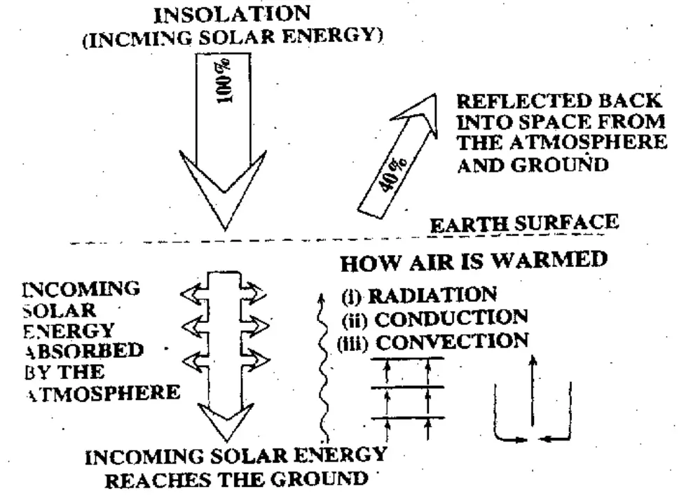
Convection: The air adjacent to the earth’s Stee on getting heating by it expands and becomes lighter, so it rises up. Cold air from the surrounding region moves in swiftly to take its place. After this the cold air also gets heated, similarly, it expands, becomes lighter, and rises up to be again replaced by cold air. In this way, heat is transferred to the various layers of the atmosphere and the whole atmosphere gets heated.
Advection: Horizontal transfer of heat is accomplished by advection or the horizontal movement of air and water. Transfer by winds and ocean currents is the most important means of distributing heat from over-heated to heat-deficient areas over the earth as a whole.
Latent heat of condensation: Water vapour holds latent heat. When the water vapour condenses its latent heat is released to the atmosphere. The energy released through this process is known as the latent heat of condensation.
Question 19. Discuss the relationship between earth’s pressure belts and planetary winds with a diagram and examples.
Answer:
Relation between World Pressure Belts and Planetary Wind System:
Atmospheric temperature and atmospheric pressure are inversely proportional. The higher the temperature, the lower will be the pressure. Because heating tends to lower the pressure on the equator, the sun shines, more or less, vertically overhead, resulting in high temperatures in the region. And due to this pressure becomes low. Thus, high temperature means low pressure and vice-versa.
Pressure Belts: The atmosphere is immensely heated due to high temperatures. The landmass is heated through insolation and the air close to the surface is heated through conduction. The heated air moves upwards giving place to low pressure. Thus, a vacuum is created to fill the gap air from a low-temperature area, i.e., air from a high-pressure region comes. Thus, the winds blow from high-pressure areas to low-pressure areas.
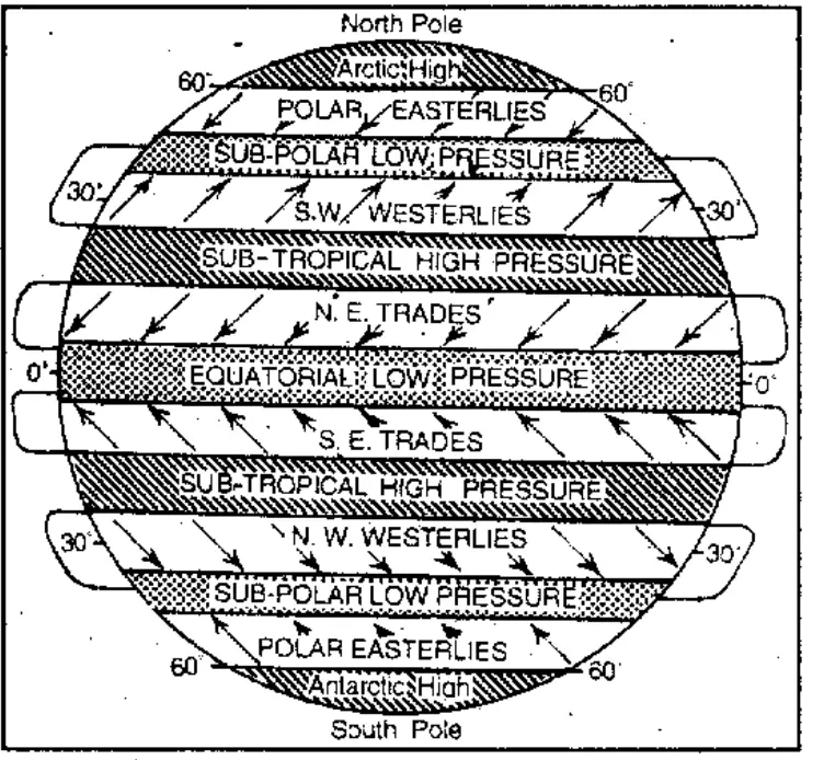
1. Equatorial low-pressure belt: All along the equator and between 5° north and 5° south of the equator, a low-pressure belt exists. This is due to:
(1)The vertical rays of the sun throughout, intense heat is caused. The hot air rises upwards as convective currents and expands,
(2)Presence of a large amount of water vapour makes the air lighter and
(3)Rotational force of the earth throws the air from the surface to make the pressure light. The movement of air is not horizontal but vertical. These ascending air are called air currents with very little winds or horizontal movement of air. Thus, the region is known also as the belt of calm or Doldrums.
2. The Sub-Tropical High-Pressure Belts: These belts occur near the tropics and between 25° and 35° latitudes in both hemispheres: The warm air from the equator rises up and blows at high levels towards the poles. But a portion of it cools down and descends in this region. Hence due to descending air currents, the pressure is high in this region.
After the air descends, it becomes warm and the capacity to retain water vapour in the North Pole the air increases, as a result, there is no condensation and rainfall. The climate is dry.
3. Sub-Polar Low-Pressure Belts: Between 60° and 65° latitudes in both the hemispheres, sub-polar low-pressure belts exist. This is mainly due to the centrifugal force due to the rotation of the earth. This is also the belt of convergence of cold polar winds and warm westerlies. Thus, continuous SS formation of cyclones reduces air pressure.
4. Polar High-Pressure Belt: Around the North Pole and South Pole high-pressure belts are found due to extreme cold, with very little centrifugal force. Here the region is frozen throughout the year and the South Pole temperature is always low.
Pressure Belts and Planetary Wind System: Planetary winds can be divided into the following three sections namely:
1. Trade winds or Easterlies: Winds, as a rule, blow from high-pressure areas to low-pressure areas. Thus, the wind blows from sub-tropical high-pressure areas (25° to 30° attitudes in both hemispheres) towards the equatorial low-pressure area.
But due to the rotational movement of the earth (from West and East), these winds are deflected to the right in the Northern hemisphere and to the left in the Southern hemisphere which is also regarded as Ferrel’s law). Thus, the direction of winds in the northern hemisphere is North-East and in the southern hemisphere is South-East. In short, these are known as Easterlies.
In the olden days for traders from Europe to North America, these were the backing winds for their ships. Hence they are also known as Trade Winds.
2. Anti-trade winds or Westerlies: From sub-tropical high-pressure areas (25° – 30°) to sub-polar low-pressure areas (60° – 65°) in both hemispheres the winds blow. According to Ferrel’s law, they deflect towards the right in the Northern hemisphere and towards left in the Southern hemisphere, i.e. they blow from. South-West in the Northern hemisphere and from North-West in the Southern hemisphere.
They are known as westerlies. Because they blow in the direction opposite to trade winds, they are also called anti-trade winds. As they come from the west, they give rainfall to the western coasts.in these latitudes. Again, in the Southern hemisphere due to the absence of big landmasses between 40° and 60° latitudes, these westerly winds blow without any hindrance and with great force or a roar; hence they are known as Roaring forties, Furious fifties and Screeching sixties.
3. Polar winds: From polar high-pressure belts to sub-polar low-pressure belts (60°-65° latitudes in both hemispheres) these winds blow, deflecting to the right in the Northern hemisphere and to the left in the Southern hemisphere. As these winds come from the cold polar regions, they are very cold and dry and blow slowly. The temperature comes down to a freezing point in areas where these winds are prevalent.
Question 20. Describe the different types of rainfall.
Answer: The different types of rainfall are:
1. Convectional,
2. Orographic,
3. Cyclonic.
1. Convectional rain: In the equatorial region, the temperature is very high all year round. There are large oceans So evaporation is very high in this region. There everyday light, hot and humid air moves up, expands and comes in contact with cold air.
The water vapour condenses and clouds are formed. Then there is rain in the equatorial region. This type of rain is called convectional rain because it is due to the convection or upward current of the wind and the rain falls practically all year round.

2. Orographic or Relief rain: When clouds on their way dash against hills, plateaus, etc. they rise up. Higher up the clouds condense and then rain falls on the slopes he mountain and the plateaus. When it goes to the other (opposite) side of the hills, plateaus, etc. it is left with little water vapour. Therefore, the rainfall is much less on the opposite side. This type of rain is called relief rain as it is caused mainly due to the relief of the land. The opposite side of the hill where the rainfall is much less is called the rain-
shadow area. The Deccan plateau is an example of a rain-shadow region in India.
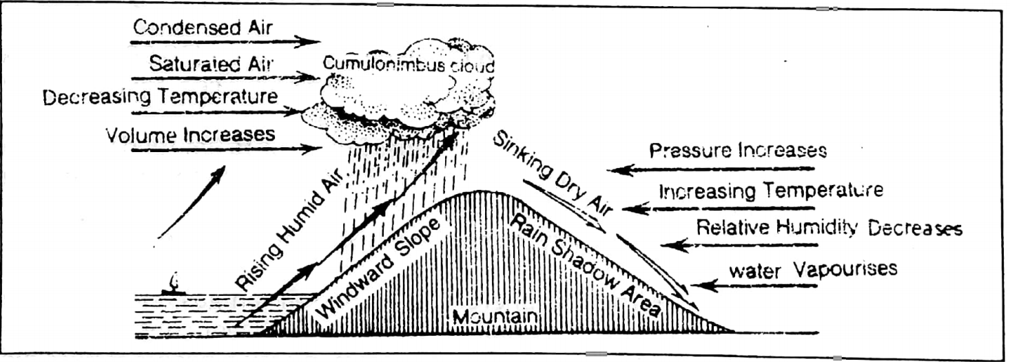
3. Cyclonic rain: When a cyclone occurs, the wind from the surrounding areas blows rapidly to the centre of low pressure and on reaching there becomes hot and rises up. Then the water vapour in the air condenses and there is heavy rain. This heavy rain is often accompanied by thunder and storm.
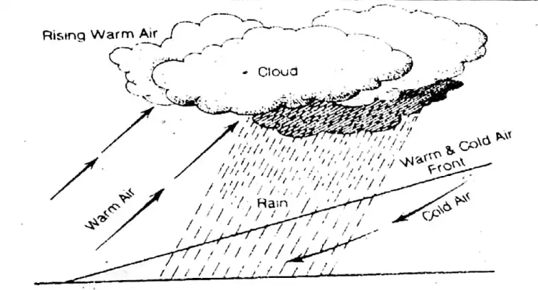
Question 21. Specify the factors responsible for thermal variation in the atmosphere.
Answer: Climatic factors (such as latitude, altitude, insolation, distance from the sea, prevailing winds, ocean currents, the slope of the land, the position of the mountains, natural vegetation, cloudiness, etc.) are the main causes of variation of temperature in the atmosphere.
1. Latitude: On the equator (0°) the sun’s rays are vertical, more or less, throughout the year and as we go towards poles (90°N and 90°S) these rays are slanting. Vertical rays are hotter. The smaller area is heated by the vertical rays and they are to travel a shorter distance. On the contrary, the slanting rays travel a longer distance and warm up a larger area. Hence, temperature decreases from the equator to the poles.
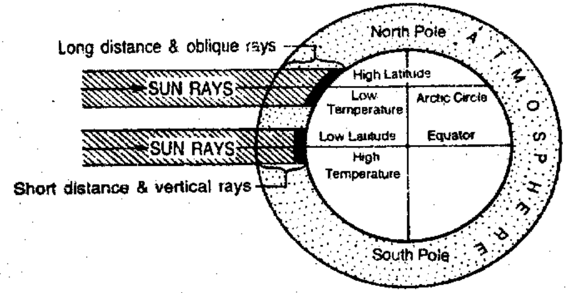
2. Altitude: For every 100 metres of height from sea level, there is a decrease of 0.6°C in temperature.
The reasons for this decrease are:
(1)Atmosphere is primarily heated by radiation and conduction of the earth’s surface, thus the lower layers of the atmosphere are warmer than the higher ones. Siliguri is situated in the plain region and is, therefore, warmer than Darjeeling situated at higher altitudes,
(2) the upper atmosphere is thinner and cannot absorb much temperature.
3. Insolation:
Heat waves from the sun radiate at he rate of 3,00,000 km per second and: only 1/2200 C2: the millionth part of solar radiation reaches the earth’s Cc) surface. The rest is reflected by the earth’s surface and atmosphere. This is called ‘Albedo’. 14% of that heat is absorbed by the earth’s surface and its atmosphere.
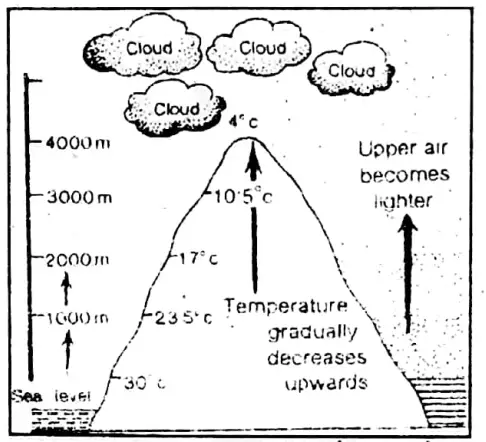
This is the sole source of earth’s heat energy. Due to the varying inclination of the rays of the sun and varying lengths of the day and night, etc., insolation varies considerably on parts of the earth’s surface.
4. Distance from the sea: Coastal areas enjoy a mode place or area situated at a distance from the sea. Calcutta enjoys a moderate temperature compared to Patna.
5. Prevailing winds: Winds coming from the sea lower the temperature in the summer season and raise the temperature in winter. Due to the westerlies (coming from the sea), there is a moderate temperature in NW Europe, whereas cold winds from Western India bring cold waves in the Northern plain.
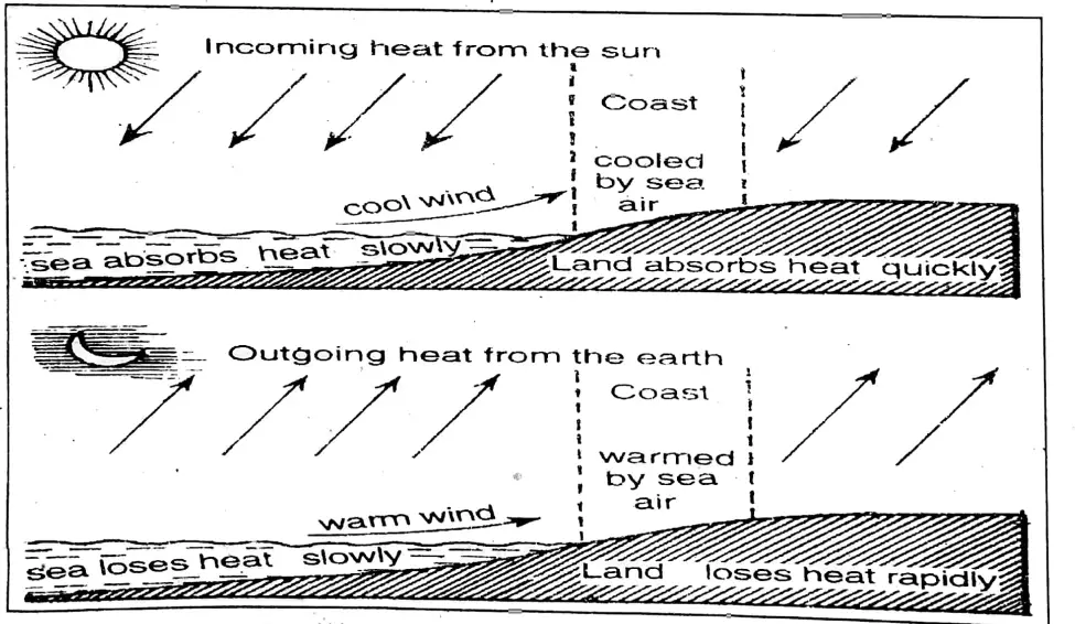
6. Ocean currents: Warm ocean currents raise the temperature of the coastal areas whereas cold ocean currents lower the temperature. Due to the warm Gulf stream, orth-western European coast is warmer and never freezes whereas the North-eastern Canadian coast is frozen most of the year due to the cold Labrador currents.

7. Slope of the land: In the Northern hemisphere, south-facing slopes are warmer than the north-facing slopes, while the conditions in the Southern hemisphere are reversed. The southern slopes of the Himalayas are warmer than that of the Northern slopes.
8. Position of mountains: Mountains check the cold wind and at the same time check the warm winds laden with water vapour resulting in rainfall. The cold winds from Central Asia are checked so much so that India is protected from severe cold and at the same time the Himalayas obstruct the moisture-laden winds that give rainfall to the Northern plain.
Geography Class 10 West Bengal Board
9. Natural Vegetation: Air is cooled above the forests, and thereby temperature is low over the land.
10. Soils: Sandy soils are cooled and heated quickly (as in Rajasthan), whereas clayey soils are cooled and heated slowly.
11. Cloudiness: Sun’s rays are obstructed by clouds to reach the earth’s surface during daytime and at night radiation is checked, as that cloudy nights are warmer and cloudy days are cooler.
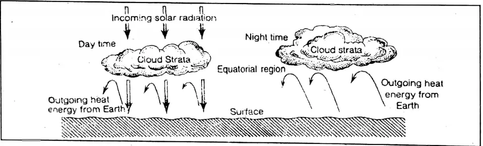
Question 22. Name the different layers of the atmosphere on the basis of temperature and describe each of them.
Answer:
Layers of the atmosphere: According to recent scientific research, the atmosphere contains the following layers:
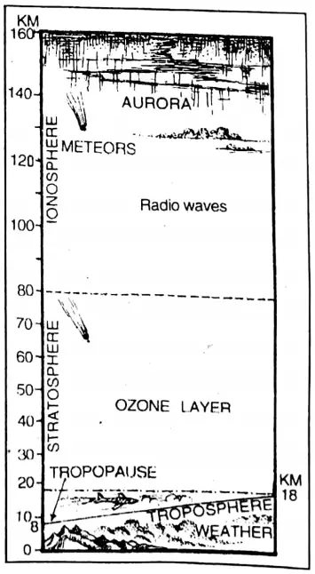
1. Troposphere: This is the lowest layer of the atmosphere. It is up to a height of 16 km on the equator and at the poles, the height is 8 km. The main feature. of this layer is that temperature decreases in relation to the height (for every 100-metre increase in height the decrease in temperature is 0.6°C) 75% of all the water vapour, cloud, and dust particles are found in this layer. That is why this layer is called the weather-making layer.
2. Stratosphere: This layer is found up to a height of 50 km above the Troposphere. There is no formation of clouds in this layer and thus there is no weather. There does not exist any danger of the storm. That is why this layer is ideal for aircraft.
3. Ozonosphere: Ozone is produced by the action of solar radiation. The maximum heating occurs near the top of the ozone layer where air temperatures are similar to those near. the earth’s land-sea surface.
4. Mesosphere: Air temperature decreases with height. The decrease in temperature becomes as low as 80°C at an altitude of about 80 km. Sometimes- 120°C is recorded.
5. ionosphere: This is also known as Thermosphere. It is a zone of ion gas, electrons and atoms. The temperature increases very rapidly. The air in this layer contains clear charges and this accesses pe waves so that radiocommunication becomes possible.
It also absorbs the deadly ultraviolet rays of the sun. Thus, it is beneficial to human beings and other living creatures. The northern lights or Aurora Borealis and southern lights or Aurora Australis occur in this zone.
Question 23. Account for the shifting of pressure belts.
Answer:
Shifting of Pressure Belts: The pressure belts shift with the apparent movement of the sun. Summer solstice (on 21st June) the sun shines vertically over the Tropic of Cancer in the Northern hemisphere. All the pressure belts move about 5° to 10° North of their average position.
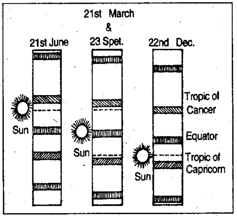
At winter solstice(on 22nd December) the sun is overhead on 21st March at the Tropic of Capricorn. Consequently, & all the pressure belts move 5° to 10° South 2istJune 23 Spet. 22nd Dec of their average location. This seasonal movement of pressure belts is known as the Shifting of Pressure Belts.
With the shifting of the pressure belts, the wind belts also shift their position which causes the change of their direction and velocity of flow.
As the pressure belts shift with the seasons, the belts of precipitation associated with them also change their positions. The regions between 30° and 40° North and South have Trade winds during their summer and they are dry.
But in winter, with the shifting of the pressure belts, these regions come under the influence of the Westerlies which bring rain. Winter rain is the main characteristic feature of the Mediterranean climate.
School Geography Class 10 WBBSE
Question 24. Write notes on Mountain and valley winds.
Answer:
Mountain and valley winds: These are local slope winds. These are periodic winds which blow along the valley slopes. In mountainous areas, the valley winds blow up the slope during the day and the mountain winds blow down the slope by night. These winds are caused due to differential heating and cooling of valley and hills tops.
1. Mountain winds: In hilly aréas, cold and dense air blowing down valley slopes during the night are called mountain winds. During the night the winds at the hill become cold and dense due to rapid radiation. This cold air, under the influence of gravity, descends down the valley slopes. It is known as air drainage.
These descending winds are called mountain winds or gravity winds or Katabatic winds. Due to these, the front occurs in the lower parts of the valleys. Therefore, citrus orchards in California and coffee fazendas in Brazil are grown on hill slopes.
2. Valley winds: In hilly areas, the warm winds ascending up the valley slopes during the day are called valley winds. During the day. hilltops get heated due to insolation and develop low pressure. The warm air of the valley bottoms blows up the slopes to take its place. These ascending winds are known as valley winds or Anabatic winds. As the winds rise, these are condensed and give heavy rain. These winds tend to moderate the temperature.