
Chapter 5 River
Rivers are the most distinctive geographical features on the earth’s surface. They are the most important sculpturing agents of landforms.
Definition Of River: Rivers are channels of running water. A river is a natural stream of running water which flows in a channel along the slope of the land towards a low land which may be an ocean, sea, lake, depression, another stream of water or large water body.
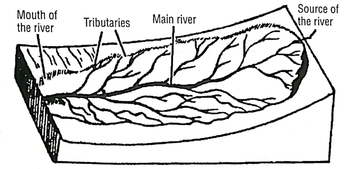
Source Of River: A river begins its flow from a spring, lake or the melting water of a glacier on a high mountain, or a rainy place on uplands and plateaus. The place from where a river begins its flow is called the source of a river.
Mouth Of The River: The place where its flow ends, is called the mouth or confluence of a river. The mouth or confluence of the Ganga is in the Bay of Bengal near Sagar Island.
Read and Learn More WBBSE Notes for Class 7 Middle Class Geography
Catchment Area: The area from which a single river system collects its waters is called its catchment area. Rainwater and ice-melt water drain through several small channels in high. mountainous regions.
These channels generally converse at the foothills to form rivers.
“WBBSE class 7 geography chapter 5 notes”
River Valley: The valley is confined by lateral banks through which the river flows.
River Basin: The region through which a river, its tributaries and distributaries are flowing is called the River basin.
River-Divide/Water Divide: A high land. (Moutain or plateau) that separates one river basin from another is called a water divide Example. Vindhya Range is a water divide between the northern and southern rivers of India. The tract of land between two adjacent river valleys is called Interfluve or a Doab.
Example. Ganga-Yamuna Doab between the river Ganga and Yamuna.
“river WBBSE class 7 geography notes”
River System: A river together with all its tributaries and distributaries make up a river system.
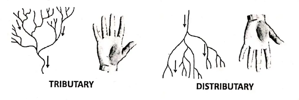
Tributaries: A small stream or river that descends to join the larger main stream or river is called a tributary. For e.g. Yamuna is the largest or main tributary of the river Ganga.
Distributaries: On its lower course, particularly near the mouth, several branches come out from the main river and they are known as distributaries, for Example. Padma and Bhagirathi of river Ganga.
Chapter 5 River Distinguish Between Tributary And Distributary
| Tributary | Distributary |
| 1. A tributary is a river joining the main river. | 1. A distributary is a river draining out of a main river. |
| 2. It increases the volume of water in the main river. | 2. It decreases the volume of water in the main river. |
| 3. It joins the main river in its middle course and lower course and helps in the formation of the flood plain. | 3. It drains out the main river in its lower course and helps in the formation of the delta. |
| 4. River Yamuna is a tributary of the Ganga. | 4. River Ganga has two important distributaries, Example. Bhagirathi in W. Bengal and Padma |
Chapter 5 River River Course
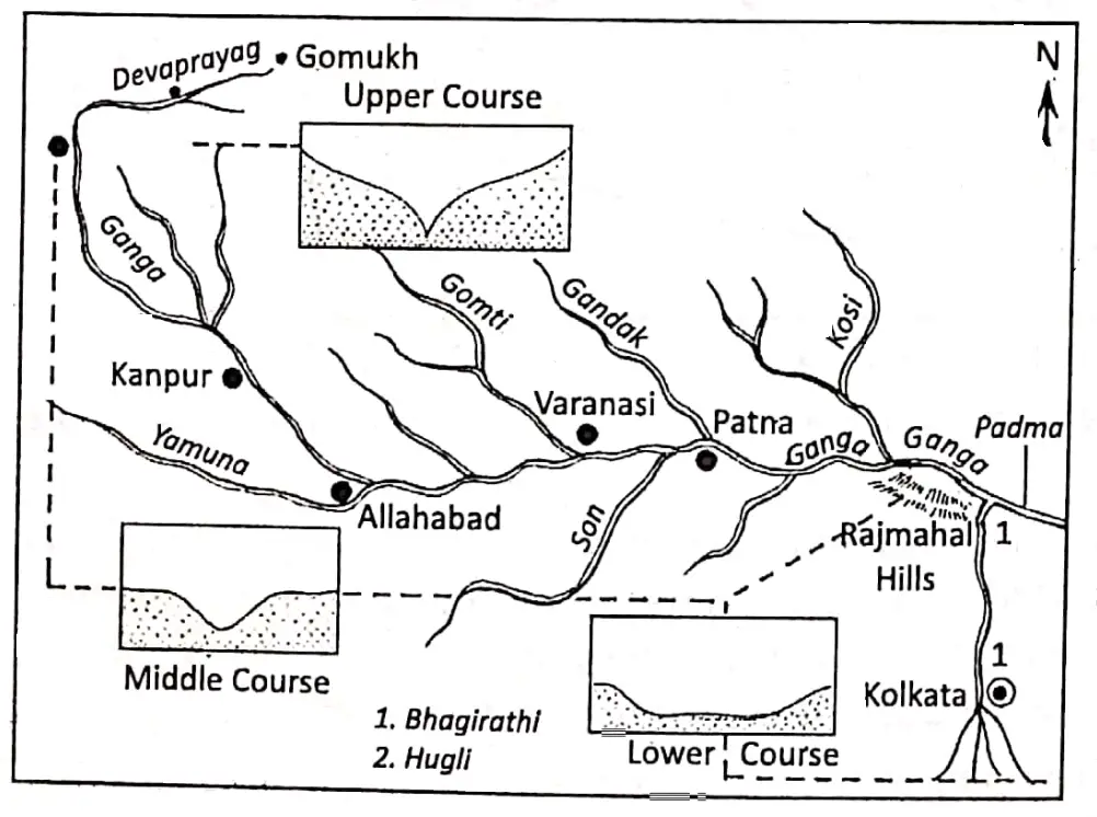
The path of a river from its source to its mouth is known as its course. From the source to the mouth of a river, there are variations in the shape, size and depth of the valley. Based on these variations Padma river course is divided into three parts
- Upper or mountain course,
- Middle or Plain Course and
- Lower or deltaic course.
The river which presents these three courses distinctly is called Ideal River. The Ganga is an example of an ideal river.
Inland River: As the river drains within the country it forms an inland river. A river which has no outlet and so does not reach the sea and empties itself into an inland lake or swamp is called an Inland or Internal or Interior River.
Luni in India is an example of an inland river. Tarim is the longest inland river in the world.
“exercise 5 solved questions on rivers class 7”
International River: When a river flows through many countries it is called an International River. Indus, Ganges, and Brahmaputra in Asia, the Rhine, and the Danube in Europe are some examples.
Perennial River: A perennial river has water all the time. When a river has its source high up in the mountainous area is generally fed by ice-melt water and it does not dry up during any time of the year. It is called the Perennial River. The Ganges is an example of a perennial river.
Non-Perennial River: Non-perennial or temporary river tastes life only during the wet season. When a river has its source in a lower plateau or hilly region it is fed by rainwater and it is filled with water during the rainy season during other parts of the year it tends to dry up.
It is called the non-perennial river. River Damodar is a non-perennial river.
What Are The Works Of A River?
A river performs three main types of work:
- Erosion,
- Transportation and
- Deposition. The erosion, transportation and deposition go on.. simultaneously. So the work of a river is known as ‘three-way’. work.
Erosion: When a river flows swiftly, it mainly wears away and breaks down its bed and sides. This is erosion. The erosional work of the river depends upon the following factors:
- The volume of water,
- The velocity of water,
- Load of the river,
Transportation: All along the course, the river carries the eroded materials from one place to another is called transportation.
The Transporting Power Of A River Depends Upon :
- The velocity of the river,
- The volume of water.
Deposition: The work in which the river deposits the transported material is called deposition. Deposition results when
- The velocity of the river decreases,
- The volume of water decreases,
- The load of the river increases,
- The transporting power of the river decreases,
- The river flows over a plain area with a gentle slope.
Chapter 5 River Relation Of The Power And Energy Of A River with Its works
Energy is the ability to do work and the amount of energy which a river has determines whether it can effectively erode its valley and transport the material it is carrying, or whether it drops the material in the form of a deposition.
The amount of erosion that a river can achieve depends on its energy.
Energy is also needed to transport the pebbles, sand, silt etc. The deposition of materials starts when their energy or power is reduced.
The Energy Or Power Of A River Depends Upon The Following Factors:
- Volume Of Water: The ability increases with the rise of the volume of water.
- Slope Of The Land: As the slope increases the velocity of flow increases.
- A load Of A River: A river with a load of pebbles and stones can erode more.
- Nature Of Land: The hardness of land exerts some influence on the work of a river. Soft rocks wear away easily; while hard rocks check the rate of erosion.
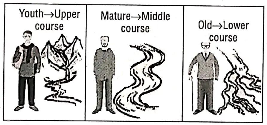
How Similar Is A River To A Human Life:
A river while flowing can be said to be like a human being. Its life cycle consists of similar three stages-youth, maturity and old age. A river may be young at its source, mature in the middle course and old near its mouth.
Youthful Stage: In its upper course a river is considered ‘youthful’ because it is young in behaves just like an energetic, restless playful boy. In this stage, it flows rapidly. A young river is most often a very powerful agent of denudation.
Mature Stage: In the middle course a river reaches lower lands. The slope is gradually reduced, so the energy and the speed of the river are reduced. Then the river behaves like a mature person, just as calm and gentle.
“WBBSE class 7 geography chapter 5 important questions”
Old Stage: When a river comes close to its mouth, near the sea or the water body into which it is going to empty itself it is called the lower course of a river. Like an old man, in its lower or ‘old’ course a river cannot move fast or straight.
To remain immortal it seeks new ways or distributaries to distribute its tribute of rich silty water.
Chapter 5 River The Mountain Or Upper Course Of A River
The upper course of a river lies in the mountains. Here river water flows very swiftly as it comes down the steep slopes. Erosion and corrosion are both characteristic features of the upper course of the river.
Landforms: The great velocity in the river has many features we see in the land as a result of the forceful down-cutting activity of the river. They are as follows:
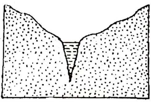
Valleys of Different Shapes and Sizes: The valleys which a river in its upper course carves out include V-shaped valleys, gorges, l-shaped valleys and canyons.
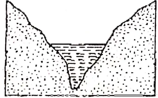
1. V-shaped valley: A V-shaped valley is one in which the river flows at the bottom of the valley which is narrow but opens out wider and wider upwards. Such a valley reminds us of the English letter ‘V’. This is why these are called V-shaped valleys.
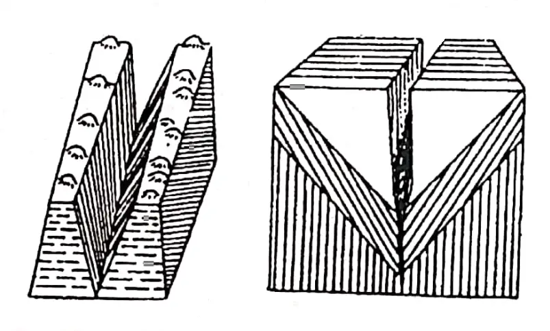
2. Gorge: Very deep and narrow river valley with vertical sides is called a Gorge. A gorge does not have much longer. Both the Indus and the Brahmaputra have carved out deep gorges in the Himalayas. The gorge of the Colca in south-east Peru is the world’s deepest gorge (4375 m)
3. Canyon: In arid or semi-arid areas of the desert little rainfall and rapid down-cutting create longer and deeper very narrow
‘I’ shaped valleys called canyons. The 446 km. long and around 1600 metres deep ‘The Grand Canyon’ of the Colorado river in the U.S.A. is the largest canyon in the world.
Distinguish Between Gorges And Canyons :
| Gorges | Canyons |
| 1. Gourges are deep and narrow and resemble a narrow V-shaped valley. | 1. Canyons are very, deep and extremely narrow, so, they resemble the English alphabet Y. |
| 2. Gorges are formed due to high velocity and rainy mountain areas. | 2. Canyons are formed in arid or semi-arid regions. |
| 3. In gorges vertical erosion is greater than lateral erosion/ as rainfall is high, either river bank gets eroded. |
3. In canyons lateral erosion is nearly nil, and vertical |
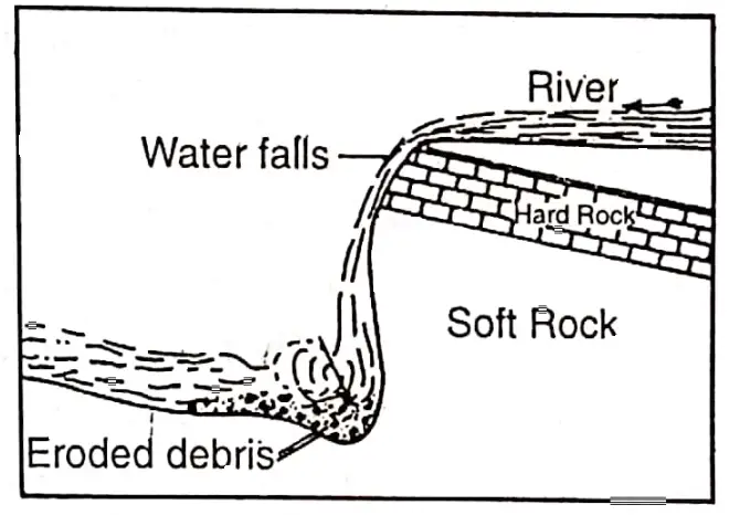
4. Water Falls: When a river waterfalls suddenly from a certain height, along a vertical slope, it is known as a waterfall. Waterfalls are formed in various ways. Some of them are mentioned below:
- When a bar of resistant rock lies transversely across a river, a waterfall is formed.
- When a fault line scarp caused by faulting stands across a river, a waterfall is formed.
- When a river descends from a glaciated hanging valley.
- Water plunging down the sharp edge of a plateau forms waterfalls. Niagara Falls in North America is a famous waterfall in the world.The Jog or Gersoppa falls (275 m) on the Sharavati river in Karnataka is the highest waterfall in India and the Salto Angel Falls (979 m) on the Rio Coroni river of Venezuela is the highest waterfall in the world.
5. Plunge Pool: The valley floor breaks where the waterfalls and a pool are created at the foot of a waterfall by plunging water. It is called a plunge pool.
6. Rapids Cascades and Cataracts: When the river flows along the unequal slopes of resistant rocks rapids, cascades and cataracts are formed. These are commonly found in a mountainous regions.
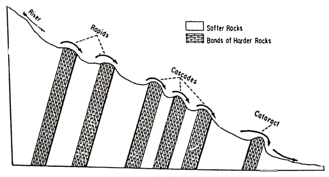
- Rapids: A stretch of swift-flowing water where a river bed suddenly becomes steeper is called rapids.
- Cascades: Cascades are a series of rapids or. combination of small waterfalls and rapids.
- Cataract: A series of rapids of a larger magnitude occurring in the river is called cataracts, as on the River Nile.
7. Potholes: A round hole worn in the rock of river beds by the swirling action of gravel and stones is called Pothole. These features are common on the mountain course of the Himalayan rivers.
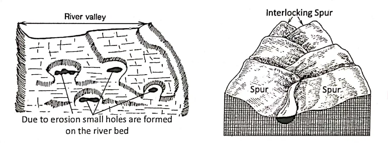
8. Interlocking Spur: A series of projections from both sides of a river valley which when viewed from above appeared to interlock with each other. This is called Interlocking Spur.
Chapter 5 River The Middle Or Plain Course Of A River
The middle course of a river begins when it leaves the mountain and enters of lowland. At this stage, the volume of water increases as some more tributaries join the river. The ‘river widens its valley.
The river is said to be mature. As the slope of the land becomes gentler in the middle course, the speed and energy of the river are reduced. The main work of the river is transportation. (Though the river also deposits some amount of the materials).
“definition and stages of a river class 7 geography”
Landforms: The remarkable landforms of this stage are the following:
1. Wide River Valley: As the energy decreases in the middle course of the river due to less velocity, lateral erosion of the river increase while vertical erosion decreases. This widens the river valley and the depth decreases.
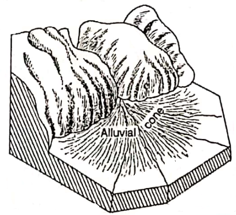
2. Alluvial Fan: A fan-shaped landform composed of alluvium deposition in the foothills where a constricted river enters a main valley or emerges from mountains onto a plain. It is called an alluvial fan or an alluvial cone.
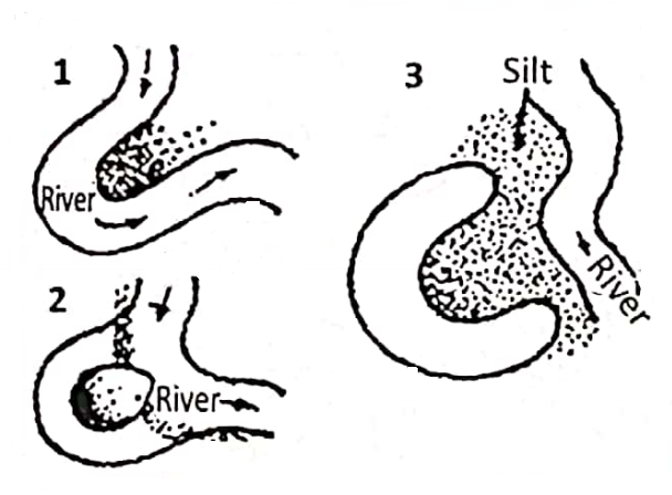
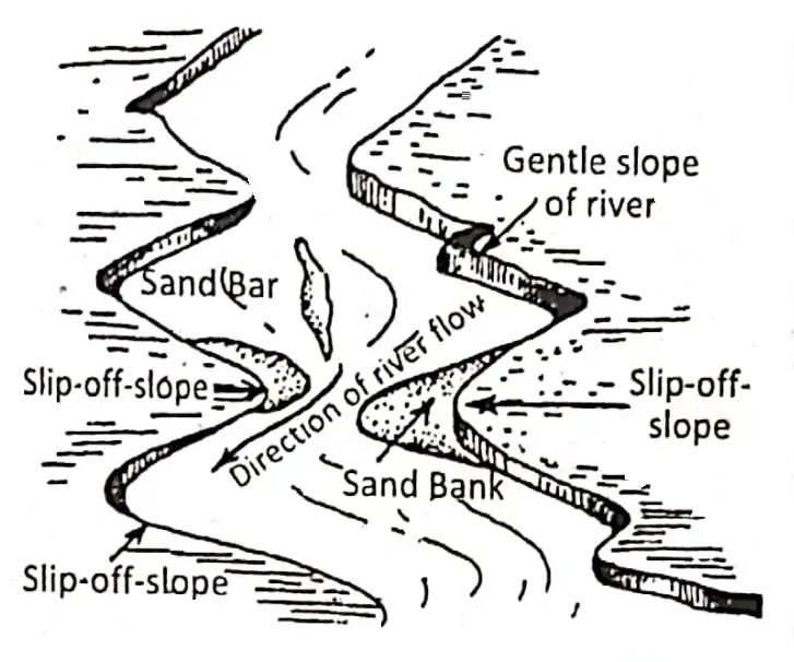
3. Meander: A pronounced curve or loop in the middle course of a river channel is known as a meander. It is so named. after the ‘Meanderez’ river of Turkey which has a serpentine or zig-zag or meandering course. The Ganga near Varanasi shows a prominent meandering.
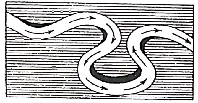
4. Ox-Bow Or Horse-Shoe Lake: In the meandering course, often the river cuts through the two bends of a meander or curve, to flow straight.
The bend or behind the river, this isolated or abandoned part of the river turns into shaped as an oxbow or horseshoe.
So this lake is called Ox-bow or Horseshoe Lake. It is seen in the flood plains of Ganga, near Patna of Bihar.
5. Sand Bank, Sand-Bar or River Island: The reduced velocity in the river in the middle course reduces the load transporting capacity of the river. Thus the river deposits a part of the load on its bank and bed.
The large deposits of sand, stones, and pebbles on the river bank are known as sand-bank and the deposits of sand, stones, and pebbles on the river bed are called sand-bars or river islands.
There are many sand banks and sand bars in the course of river Ganga in Bihar and west Bengal and the course of river Brahmaputra in Assam.
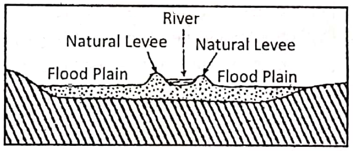
6. Flood-Plain and Natural Levee: In the rainy season when extra water is added, the river floods its surrounding areas. By repeated floods sands, and silts deposited on both the banks of a river gradually build up plain.
“formation of river landforms WBBSE geography”
It is called Flood-Plain.A bank of alluvium bordering a river that is built up by deposition and lies above the level of the flood plain.
As this embankment is formed naturally, so it is called Natural Levee. Natural levees are found along the course of the great rivers such as the Ganga, Howang-Ho and Yangtze.
Chapter 5 River The Lower or Delta Course of a River
When a river arrives at its mouth near the sea or any large water body slope of the land becomes very much less or gentle, so the velocity is very low.
This part of the river is called Lower or Delta course. From Rajmahal hill in Jharkhand to the mouth of the Ganga at the Bay of Bengal is the Lower or Delta course of the river Ganga.
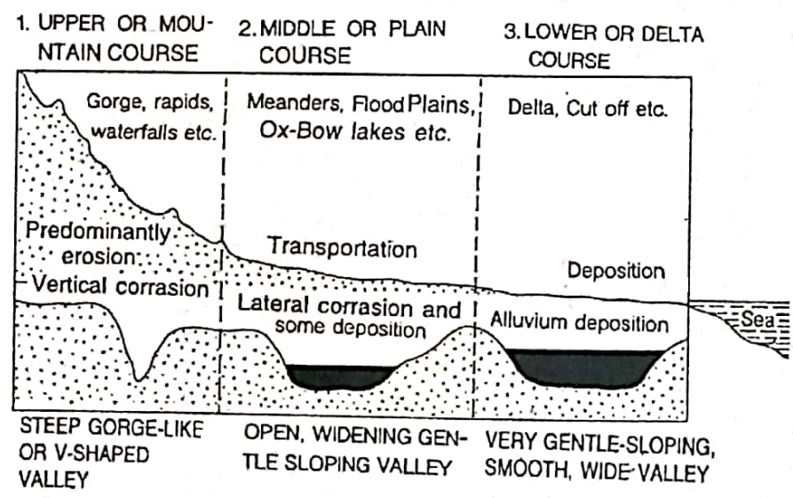
Landforms: The very low velocity of the river, the principal work of a river is deposition. The major features produced in this course of the river are:
- Very wide river valley,
- Flood plains, natural levees, oxbow or horse-shoe lakes, sandbanks sand sand-bar etc. are also seen in the deltaic course too,
- Delta, and
- Estuary.
1. Very wide (Broad) And Shallow River valley: As the river velocity is low, down-cutting is reduced but side-cutting is increased. So the depth of the river decreases and the valley widens a lot.
2. Sand Bank, Sand Bar, Flood-Plain, Natural Levee And Horse-Shoe Or Ox-Bow Lake: Like the middle or plain course of a river sand bar, sandbank, flood-plain, natural levee and ox-bow or horse-shoe lakes are also formed in the lower course and these are more in numbers.
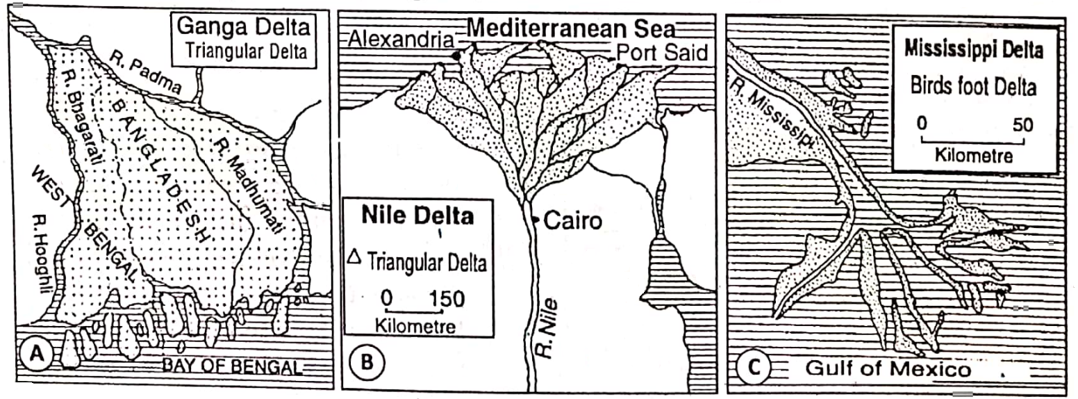
3. Delta: On entering the sea a river deposits all the load at the mouth to form an alluvial triangular island which looks like the Greek letter Slip-off-slope A (delta). So, this island is called ‘Delta’. The Ganga- Brahmaputra delta is the largest delta in the world.
Chapter 5 River Favourable Conditions For The Formation Of Delta
- The river should have a long, mountainous upper course. It increases the load of sediment.
- The river should have a long lower course.
- The river should have a number of tributaries to increase its load.
- There should be an absence of large lakes in the river course.
- The sea should be shallow near the delta.
- There should be no strong currents and tides at the mouth of the river.
“upper, middle, and lower course of a river class 7”
Types Of Beltas: Three types of delta are usually distinguished:
- Arcuate or fan-shaped, for Example. Nile delta.
- Cuspate or pointed like a tooth, for Example. The Ebro.
- Birds foot type with fingering branches Example. Mississippi delta.
4. Estuary: When a river enters the sea through a deep funnel-shaped tidal mouth where fresh and saline water is mixed. This wide mouth of the river is called the Estuary. The estuary of Ob River is the widest in the world.
Distinguish Between Delta And Estuary
| Delta | Estuary |
| 1. A delta is a triangular-shaped alluvial land formed at the mouth of a river. | 1. An estuary is a funnel-shaped channel formed at the mouth of a river. |
| 2. It is formed by deposition when there is the absence of high velocity of tides and currents. | 2. It is formed when deposition does not take place due to strong tides and currents. Lateral erosion also increases here. |
| 3. Ganges-Brahmaputra form a large delta but Narmada-Tapti do not form deltas. | 3. River Ganges, Matla, Ob, Amazon etc. have estuaries at their mouths. |
How Far Can A River Influence Human Beings
The rivers are closely related to our lives. The relationship constantly changing as men themselves have changed.
“erosional and depositional features of rivers WBBSE”
The importance of the rivers may be summed up as follows:
- The rivers are the source of drinking water and other domestic need.
- The rivers are an important source of irrigation water and new fertile alluvium.
- The role of navigable waterways and sites for ports.
- The rivers are the source of industrial water.
- We do get temporary benefits when we construct artificial dams on rivers to control floods.
- The rivers of the undulating or mountainous surface are the source of hydel power.
- These are the sources of fish and mineral ores, e.g. gold and tin.
- The rivers are the scavenger of pollutants.
- These make our lives developed and prosperous.
- River valleys are often suitable for cultivation, urban settlements and the growth of civilizations. The earliest civilizations on earth thrived on the banks of
- the rivers (For example. the Indus, the Egyptian, the Sumerian civilization).