
Chapter 4 Pressure Belts And Winds
Pressure Belts And Winds
The atmosphere or the sphere of the air envelope the layers of invisible gases that surrounds the earth. It is held to the earth by the force of gravity and rotates with it. It represents the gaseous realm of the earth. It is mobile/ elastic, both compressible and expansible. The atmosphere is a vital part of human existence on earth.
Air Pressure: The atmosphere is composed of air and other particles like water vapour and other materials. Though the air is very light, it has weight. It also exerts pressure on the earth’s surface. The weight of air on the unit area of the earth is called ‘air pressure or atmospheric pressure’.
Read and Learn all WBBSE Notes For 8 Class Middle School Geography
It was Toricelli, a disciple of Galileo, who first practically measured air pressure in 1643. The atmosphere exerts a pressure of more than kg/sq. cm (1-03 kg/cm or 6-68 kg/inch) at sea level or 760 mm/cm or 76 cm or 1013-25 millibars. Air exerts pressure equally on all sides, we are supported by an equal pressure of air on all sides of our body. So, we do not feel this pressure.
“WBBSE Class 8 Geography Chapter 4 notes, Pressure Belts and Winds”
There are two types of air pressure—(1)High pressure and (2) Low pressure.
More air molecules present in a definite volume of air develop high pressure and fewer air molecules present in that airmass form low pressure. So, an air of high pressure is dense and that of the low pressure is thin. More than 1013-25 millibar pressure is called ‘High pressure’ and less than 986 millibar pressure is called ‘tow pressure’.
Variation in Air Pressure: Air pressure is not uniform over the surface of the earth but varies from place to place for the following conditions:
| Class 8 General Science | Class 8 Maths |
| Class 8 History | Class 8 Science LAQs |
| Class 8 Geography | Class 8 Science SAQs |
| Class 8 Maths | Class 8 Geography |
| Class 8 History MCQs | Class 8 History |
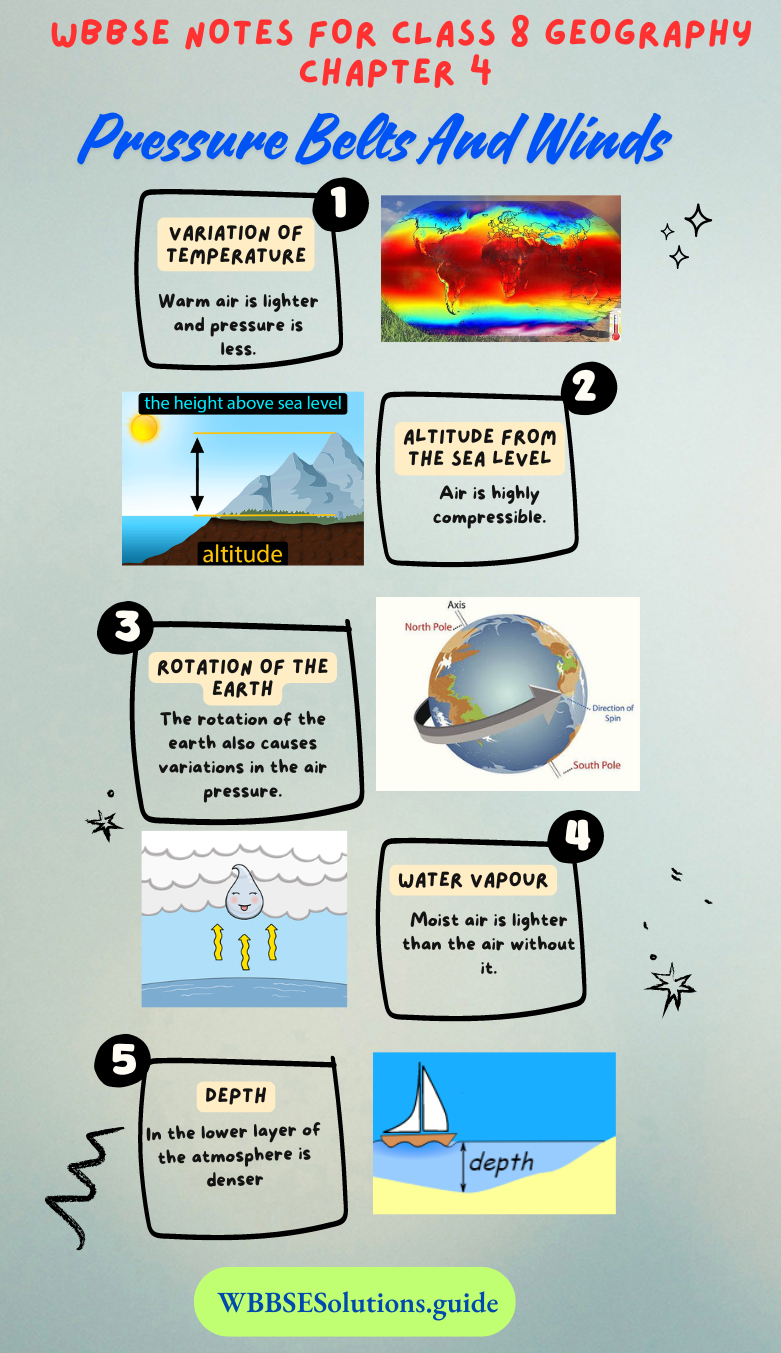
- Variation of Temperature,
- Altitude from the sea level,
- Rotation of the earth,
- Presence of water vapour,
- Depth of the atmosphere.
- Variation of Temperature: Warm air is lighter and pressure is less. So, it goes up forming a low-pressure zone. We call this low pressure because the air is less dense, and exerts low pressure. On the other hand, cold air which is heavier and denser exerts more pressure and settles down on the ground forming a high-pressure zone.
- Altitude from the sea level: Air is highly compressible. So, it is denser in the lower parts of the atmosphere and lighter with an increase of altitude. This air pressure will be higher over a lowland area and lower over a higher mountainous area.
- Rotation of the earth: The rotation of the earth also causes variation in the air pressure. The air is thin around the sub-polar areas because of the rotation of the earth swings the bulk of the air towards the Equator.
- Water vapour: Moist air is lighter than the air without it. Dry air is heavier than moist air because it contains more nitrogen and oxygen than humid air. This is why air pressure is low during the rainy season and in winter air pressure is high.
- Depth: In the lower layer of the atmosphere is denser than at the higher level and therefore the pressure is high but as we go higher up the pressure of the air decreases because fewer air molecules are present in that airmass.
Chapter 4 Pressure Belts And Winds: Air Pressure Belts
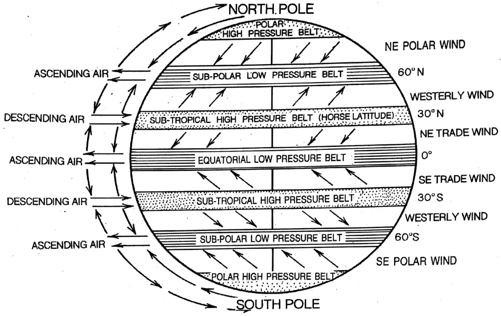
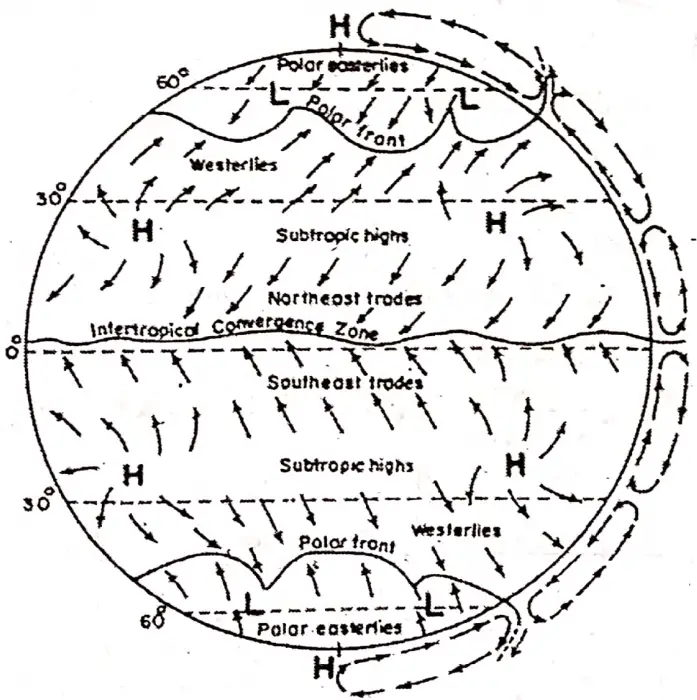
There exists a definite pattern of alternate high and low-pressure belts over the earth’s surface. A ‘Pressure Belt, is a zone of uniform width, around the earth, extending in an East-West direction parallel to the lines of Latitude. On the earth’s surface, there are in all seven pressure belts. Four belts of high-pressure separate three low-pressure belts.
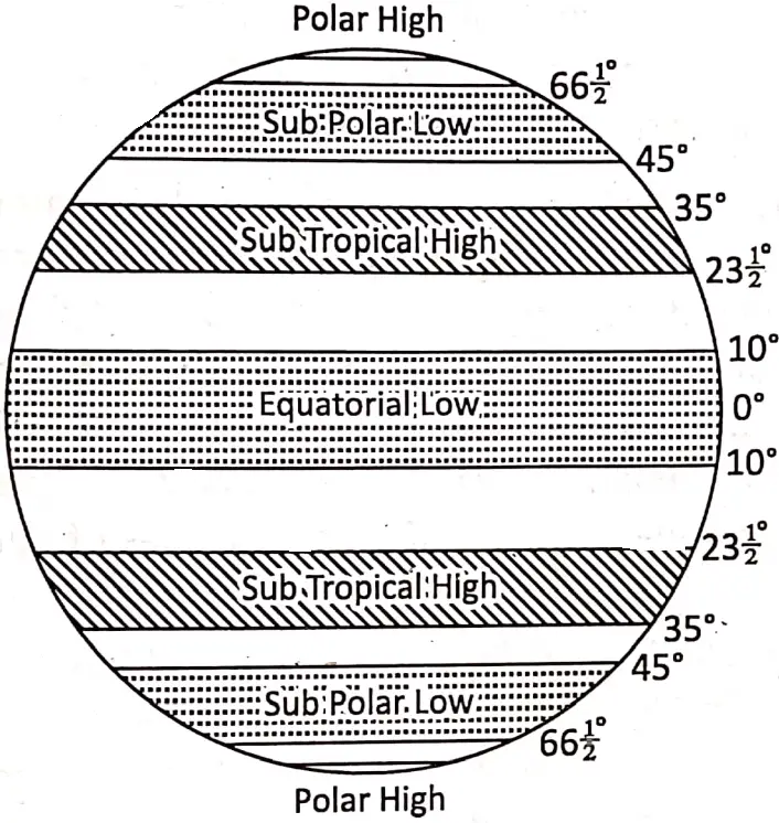
1. The Equatorial Low-Pressure Belt: The equatorial belt of low pressure extends from the Equator to 5°N and 5°S latitudes. This belt has been formed due to
- Vertical sun rays fall on this region throughout the year as such, air is warm and light all year round. The air expands and becomes lighter, rises upwards as convection currents and finally ascends to form this low-pressure belt,
- Presence of water vapour is more in this region. So water vapour further helps in lowering the air pressure there,
- Due to the rotation of the earth bulk of the air above this region swings towards the north and south, as such, air becomes, thin and formed low pressure.
Equatorial calm or Doldrums: The belt of equatorial low pressure is termed as ‘Doldrurns’-because there is no horizontal movement of air or wind. Air is continuous by ascending from this region. Thus, in the equatorial region, ‘Calm’ conditions prevail and the region is called Equatorial ‘calm or ‘Doldrums’ which means ‘to Stagnate’.
2. And 3. Sub-tropical High-Pressure Belts: Two sub-tropical high-pressure belts are formed near the tropics (Tropic of Cancer and Tropic- of Capricorn} and extend between 30° – 35° North and South latitudes.
The causes behind the formation of these two high-pressure belts are:
- The warm and moist air over the Equator rises, cools and spreads towards the north pole and the south pole. On reaching latitudes 30° North and 30° South the air becomes cool, dense and heavy. Consequently, it descends to form these high-pressure belts. These are regions of calm with light winds and quiet, stable weather conditions,
- Due to the rotation of the earth, cold air from the polar region swings towards this region.
Sub-tropical calm: Horse Latitude— in sub-tropical high-pressure belts, the air is calm. So, these high-pressure belts are known as the sub-tropical calms’, it is also frequently known as Horse latitudes’, it is explained that, in the colonial days of sailing ships carrying horses used to sail from Europe to the West Indies.
On the way, over these regions, because of the absence of horizontal wind, ships had to unload cargo. So, many horses were thrown into the Atlantic Ocean to make the ships lighter to conserve drinking water. Since then, the region between ^ ~~35° (25°—35°) parallels in both hemispheres are frequently called “Horse Latitudes’.
“Class 8 WBBSE Geography Chapter 4 notes, Pressure Belts and Winds study material”
4. And 5. The Sub-Polar Low-Pressure Belts over the Arctic or Antarctic circle: Two subpolar low-pressure belts are located between 60°—65° North and South latitudes.
In these belts low pressure develops because—
- The earth’s rotation swings the bulk of the air from these areas towards the Equator
- Cold winds of the polar highs expand when they reach these two regions and
- Warm and light westerlies blow above cold and heavy polar winds. So, in the sub-polar region, the density of air is less therefore, pressure is also low.
6. And 7. Polar High-Pressure Belts around North Pole and South Pole: Two high-pressure belts are found around the North Pole and South Pole because—
- This is a region of permanently low temperature, as such, the pressure of the air is high,
- Evaporation is less, so water vapour is almost absent and
- The air that rises above the sub-polar regions swings and descends over these areas.
Pressure cells: Variations in the distribution of land and water cause variations in air temperature and pressure over land and water even in the same latitudes. For this, there is no continuous belt of pressure all over the world.
The discontinuity of these bands of air temperature and pressure over the same latitudes forms isolated small cells of air pressure.
These concentric pressure centres or cell are known as ‘Pressure Cells’. in the northern hemisphere is greater variation due to the location of continents and oceans. Therefore, air pressure cells are seen more often over the northern hemisphere.
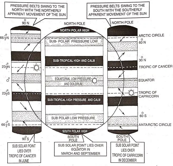
Shifting of Pressure Belts and Planetary Winds: The pressure belts of the world are formed mainly because of the heat of the sun. So, the pressure belts shift with the apparent annual movement of the sun.
Owing to the revolution of the earth, there is an apparent movement of the sun from the northern hemisphere to the southern hemisphere with the movement of the sun, the pressure belts shift northward in the summer and southward in winter.
In June when the sub-solar point (vertical position of the sun) lies over the ‘Tropic of Cancer (231/2° North), it is summer in the Northern Hemisphere, as such, the pressure belts are shifted by 5° to 10° north of their normal positions.
“WBBSE Class 8 Geography Chapter 4, Pressure Belts and Winds study guide”
Similarly, in December, when the sun lies over the ‘Tropic of Capricorn (23%° South), it is summer in the Southern Hemisphere and the pressure belts shift by 5° to 10° south of their average positions.
With the shifting of the pressure belts, the wind belts also, shift their position which causes the change of their direction and velocity of flow. The swing of this whole wind system has a great impact on the climate of the region lying between 30° and 45° parallels of latitude in both hemispheres.
These regions come under the ‘Trade winds’ which give rain to the eastern coasts of the southern part of Argentina, and Sudan but do not give any rain in the western margins (e.g. Mediterranean lands, southern chile) as they are off short there.
In winter, these regions come under the influence of the westerlies and receive sufficient rainfall. So, it is rightly said that rain follows the sun as the entire system of pressure belts and planetary winds follow the sun.
Chapter 4 Pressure Belts And Winds: Winds
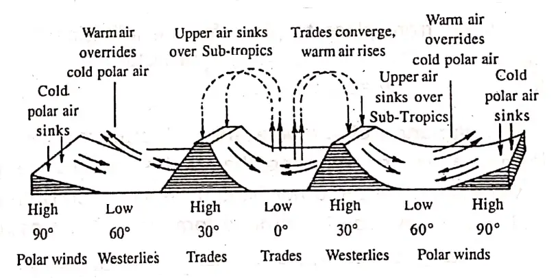
The unequal distribution of heat on the earth’s surface causes the formation of high and low-pressure belts over the earth. Lighter air ascends to form the low-pressure belts while heavier air descends to form high-pressure belts.
Air current: The vertical movement of air over the earth’s surface is called ‘air current’.
What is wind: The horizontal movement of air from high-pressure to low-pressure areas along the earth’s surface is called ‘wind’.
Centrifugal force: The fictional force that acting, moves or tends to move away from a centre to an outward side is called ‘centrifugal force’.
“WBBSE Class 8 Pressure Belts and Winds notes, Geography Chapter 4”
Coriolis Force: It was named after the French mathematician Gaspard de Coriolis, who first described it inl835. A force resulting from the rotation of the earth deflects moving bodies to the right in the Northern Hemisphere and to the left in the Southern Hemisphere. This affects winds, ocean currents and humans.
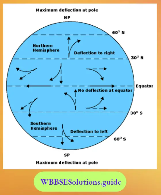
Ferrel’s Law: The winds are deflected from their true gradient course due to the earth’s rotation. U.S. meteorologist William Ferrel following Coriolis force formulated a law in 1859 to deduce the direction of winds in the northern and southern hemispheres. It is known as Ferrel’s Law.
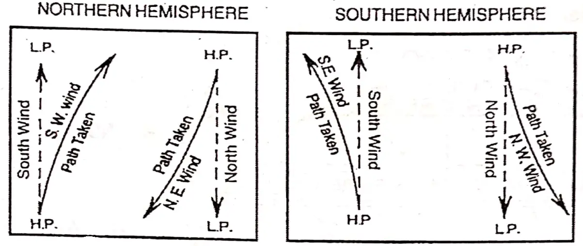
According to Ferrel’s law: If we stand with our faces in the direction in which the wind northern hemisphere southern hemisphere is blowing from high pressure to Westerlies are deflected to their right as South-West Westerlies.
“Class 8 WBBSE Geography Chapter 4, Pressure Belts and Winds easy explanation”
In the southern hemisphere, Trade winds are deflected in their left as South-East Trade Winds while westerlies become North-West Westerlies.

Buys Ballot’s Law: A Dutch meteorologist not only Christoph Buys Ballot postulated a law in 1857 which relates the wind direction to the position of air pressure areas.
According to this law, “If an observer in the northern hemisphere stands with his backs to the wind atmospheric pressure will be lower on his left hand, in the southern hemisphere pressure is lower on his right. This is the result of Coriolis’s force on the earth.
Classification of winds: Winds can be classified into four major types:
1. Planetary winds,
2. Periodical winds,
3. Local winds and
4. Sudden or Irregular winds.
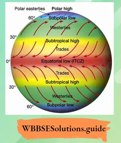
1. Planetary or Permanent Winds: In the surface of the earth, certain winds blow constantly in a particular direction from the high-pressure belt to the low-pressure belt throughout the year. These winds are called ‘Prevailing’ or permanent or Planetary or Constant winds. These winds are of three types—
- Trade winds,
- Westerlies, and
- Polar winds.
Air Pressure Belt
- An account of Trade Winds: The winds that blow regularly in a definite direction from the tropical high-pressure belts (30°—35° North and South latitudes) to the equatorial low-pressure belt in the both hemisphere are called ‘Trade Winds’. The name ‘trade’ is derived from the German word ‘trade’ which means ‘Track’. These winds blow in the same direction in a definite track, as such, these winds are called ‘Trade Winds’.
These winds were also helpful to the early traders who depended on the wind when sailing in the seas; hence, the name ‘Trade Winds’. In the northern hemisphere, their direction is north-easterly and in the southern hemisphere, south-easterly. As the trade winds come from the east in both the hemispheres, they are also called the ‘Easterlies’.
“WBBSE Class 8 Geography Chapter 4 notes, Pressure Belts and Winds PDF”
Origin of the Trade Winds: The Trade Winds are originated from a pressure gradient (difference in pressure) of the Sub-Tropical High-Pressure Belt to the Equatorial Belt of Low Pressure.
Types of Trade Winds: Trade Winds are of two types—
- Worth-East Traoe Wind
- South-East Trade Wind.
- Worth-East Trade Wind: In the Northern Hemisphere, winds blowing towards the Equator, are deflected to the right and according to Ferrel’s Law become ‘Worth-East irade Winds.
- South-East Trade Wind: Southern Hemisphere deflection of the wind is towards the left and the winds become ‘South-East Trade Winds’.
ITCZ or Inter-Tropical Convergence zone: A zone of low atmospheric pressure near and more or less parallel to the equator (5° North and 5° South), where the North-East, and SouthEast. Trade winds meet, being thus associated with the Doldsums is called ‘I.T.C.Z.’
The velocity of Trade Winds: In the Northern Hemisphere as the landmasses are the more, the velocity of the North-East Trade Wind is about 16 km/ hour. While in the Southern Hemisphere, water bodies are more, as such, the velocity of the South-East Trade Wind is a little more, about 22-23 km/hour.
Influence of Trade Winds: Since these Trade Winds blow from the cooler sub-tropical latitudes to the warmer tropics, they have a great capacity for holding moisture. On their way, while crossing the open oceans, they pick up moisture and give heavy rainfall to only the eastern parts of continents within the tropics.
“WBBSE Class 8 Geography Chapter 4, Pressure Belts and Winds important questions”
While reaching the western part of the continents they get dry and give no rain. It is one of the reasons that the world’s great deserts like California, Sahara, Thar (India), Atacama (Peru and Chile in South America), Kalahari (In Africa) and the West Australian Desert have been formed.
2. Westerlies: The Winds that blow from the Sub-tropical High-Pressure belts towards the Subpolar Law Pressure belts in both hemispheres are called ‘Westerlies’. In the Northern Hemisphere, their direction is south-westerly and in the Southern Hemispheres, it is north-westerly. As they blow from the west in both the hemispheres, they are called the ‘Westerlies’.
Origin of the Westerlies: Due to the rotation of the earth low pressure develops over the Arctic and Antarctic Circles, while there is relatively high pressure over the Tropic of Cancer and Tropic of Capricorn. So, winds move from these high to the low-pressure belt as Westerlies.
Types of the Westerlies: The Westerlies are of two types—
- South-West Westerly and
- North-West Westerly.
Under the effect of Coriolis Force, westerlies are deflected. Following Ferrel’s Law, they become South-West Westerly in the Northern Hemisphere and North-West Westerly in the Southern Hemisphere.
Roaring Forties: In the southern hemisphere between 35° to 60° South latitudes westerlies are best developed due to the vast expanse of oceans and the absence of extensive landmasses. Westerlies of this zone are/therefore blow uninterruptedly with much greater force. It is called ‘Brave Westerlies’. When brave westerlies blow along 40° South depending on violent sounds made by these brave westerlies are called ‘Roaring Forties’.
Furious Fifties: When the brave westerlies blow along 50° South parallels of latitude then it is called ‘Furious Fifties’.
Screeching/Shrieking Sixties: When the brave westerlies blow along the 60° South parallels of latitude, then it is called ‘Screeching or Shrieking Sixties’.
Influence of Westerlies:
- These winds are on-shore winds on the western coasts of continents and bring much precipitation. But the eastern parts remain comparatively dry.
These winds are variable in strength and direction. Cyclones and anticyclones produce uncertain weather. The weather is changing due to clouds, fog, gales and snowfall. - The westerlies blow uninterruptedly with much greater force and regularly throughout the year. These are best developed in the southern hemisphere due to the large expanse of oceans, and the absence of extensive landmasses. Here these are termed as “brave westerlies” or “brave Westwinds”.The latitudes in which westerlies blow are called, “Roaring Forties, “Furious Fifties”, and “Shrieking Sixties”. These stormy violent winds are dangerous for shipping.
- Westerlies bring winter rainfall in many parts of the Mediterranean region. It is to be noted that westerlies bring rainfall to the western coasts of the continent of temperate lands.
3. Polar Winds: Polar winds blow from Polar Highs of the Arctic and Antarctic to the sub-polar lows of the Arctic circle and Antarctic circle respectively. As these winds originate from the poles, they are known as ‘polar winds’.
The velocity of Polar Wind: Polar winds are very much weak, especially, in the northern hemisphere. In the southern hemisphere, it is relatively strong.
The latitudinal extent of Polar Winds: Blowing between 60° to 85° Parallels of latitudes.
Effects of Polar Winds:
- Polar winds are very cold and dry as they blow from the poles and from the coldest parts to a warmer region.
- They are extremely cold and are responsible for a bitterly cold climate.
- They blow in high velocity and bring about cyclones, and blizzards.
In the South Pole these stormy winds have greater velocity and intensity of force Sometimes, a situation of anticyclones prevails there.
Chapter 4 Pressure Belts And Winds: Periodic Winds
The winds which blow from time to time or in a certain period (season) of a year, are called. ‘Periodical winds’ viz.
- Sea Breeze,
- Land Breeze,
- Monsoon-Land and sea breezes are a periodic type of winds and consist of a conventional system of winds.
These are caused by the differential heating of land and sea. These affect a narrow strip along the coast. These are also known as “monsoons on a smaller scale”.
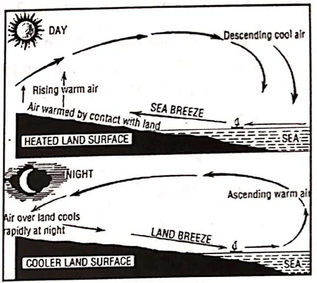
1. Sea Breeze: During the daytime, the land gets rapidly heated up than the sea. The warm air rises to form a low pressure locally on land.
The sea being cooler develops a high pressure. So, a cool sea breeze blows from the sea to land. Thus, the winds complete a convection cycle.
Effects:
- It brings cool and fresh air from the sea.
- Sea Breeze moderates the temperature of the coastal areas resulting in an equitable or maritime climate,
- Its influence does not exceed 30 km from the coast.
2. Land Breeze: During the night the land becomes cooler than the sea. The cold and heavy air produces a local high pressure on land. The sea remains comparatively warmer with a low pressure. Therefore, a land breeze blows from land to sea. These are effective under calm, cloudless sky.
Effects:
- The fishermen take advantage of the outgoing land breeze and sail out within the morning. They return with the incoming sea breeze in the evening.
- The return current of warm air from the sea has a moderating effect on the temperature.
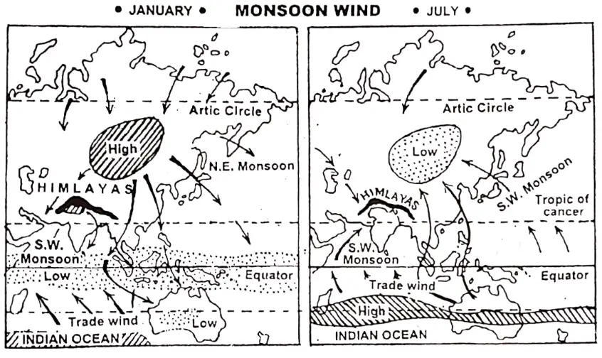
3. Monsoon Winds: The term ‘Monsoon’ is derived from an Arabic word meaning ‘season’. The winds that blow with the change of seasons is called ‘monsoon winds’. Thus monsoon winds are seasonal winds.
The term was first used for the monsoon winds blowing over the Arabian sea. In this wind system, there is a reversal of wind direction according to seasons. In summer, monsoons blow from sea to land and in winter monsoons blow from land to sea.
Origin: Monsoons are land and sea breezes on a large scale. These winds have a thermal origin. These are caused by the differentia! heating and cooling of land and water. The chain of events is from temperature through pressure and winds to rainfall.
“Class 8 Geography Pressure Belts and Winds notes, WBBSE syllabus”
In summer, the land gets more heated than the sea resulting in a low pressure on the land masses and a high pressure overseas. The winds blow from sea to land. Land breeze and sea breeze follow a daily rhythm over a small coastal areas.
Necessary conditions: The monsoons are developed under the following conditions.
- The pressure of a large landmass (Continent).
- The presence of a large ocean.
- Long coastline.
- Seasonal extremes of the temperature of land and water.
Areas: Monsoon winds mostly blow in tropical areas. The Himalayas separate these areas into two parts.
- East Asian Monsoons blowing over China, Japan and Indo-China.
- Indian Monsoons of India, Pakistan, Bangladesh and Myanmar.
Pressure Belt On Earth
Summer Monsoons: In summer the central, the central parts of landmasses like Asia get more heated than the seas and oceans around them. Therefore, low pressure develops over the land. As a result winds blow from the seas to land in summer. These winds are called the summer monsoons’. They bring heavy rain as they come from the seas.
Winter Monsoons: During winter, high pressure develops over the land masses and low pressure over the seas and oceans. Therefore, the winds start blowing from the landmasses towards the seas and oceans. These winds are called ‘winter monsoons’. These are dry winds for central part of Asia, particularly for most of India.
Periodical Local Winds:
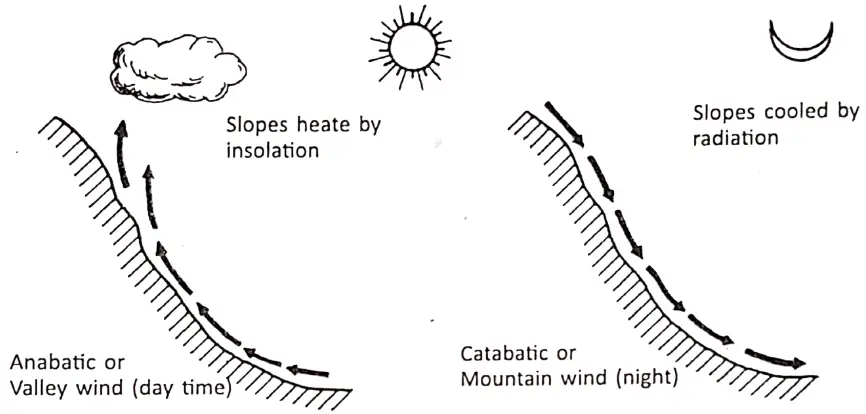
Anabatic and Catabatic Wind: These are local slope winds. These winds are periodic winds which blow along the valley slopes. These are also diurnal in character. Mountain winds blow down the slopes at night while the valley winds ascend the slopes during the day.
Anabatic or Valley Wind: A local wind that blows upslope during the day in mountain areas is called ‘anabatic’ or ‘valley wind’. The air above the valley slopes is heated to a greater extent than air at the same height above the centre of the valley.
“WBBSE Class 8 Chapter 4 Geography, Pressure Belts and Winds solutions”
Air thus rises up from the slopes and feeds an upper return current. As the winds rise, these are condensed and give heavy rain. These winds tend to moderate the temperature.
Catabatic or Mountain Wind: A cold downslope wind caused by the gravitational movement of cold dense air near the Earth’s surface is called ‘Catabatic’ ‘mountain wind’ ‘canyon wind’, or ‘gravity wind’.
During the night the winds at the mountain tops become cold and dense due to rapid radiation. This cold air, under, the influence of gravity, descends down the valley slopes. It is also known as ‘nir drainage’. Due to these, the front occurs in the lower parts of the valleys. Therefore, ‘citrus orchards’ in California and coffee ‘agendas’ in Brazil are grown on mountain or hill slopes.
Chapter 4 Pressure Belts And Winds: Local Winds
Due to local differences in heating and cooling on account of the configuration of land or distribution of land and water, certain winds are caused which are to be found even in the generalised wind belts of the world. These are called ‘Local Winds’. Most of the local winds are developed by local depression.
They affect only limited areas and blow for a short period. Some of the local winds are as follows:
- Loo: Loo is a hot dry and dusty wind. It blows in the northwestern part of India. It desiccates and dries up surface moisture. It blows in the month of May and June over the northern plains, especially in U.P. in India.
- Andhi: During summer months very dry sand storms are very frequent in the northwestern part (Rajasthan) of India. These dust storms are locally known as ‘Andlll’ because it overcasts the sky with dust and cloud.
- Nor’wester’s (Kalbaishakhi): During the afternoon of summer months (Chaitra- BaishakK) life” thunderstorms along with rainfall mainly occur in West Bengal, it is known as ‘Kalbaishakhi’ 0ne Rainshadow region of India is the Deccan plateau or the northern part of the Meghalaya Plateau (Leeward side of the slope).
- Chinook: Chinook winds are experienced on the leeward eastern slope of the Rockies and Prairies in the U.S.A. and Canada. It causes snow to melt and disappear very quickly for which Is known ns Snow-eater’, It thus makes pasture available. This raises the temperature of the area by 15C to 20C. In a couple of hours.
- Fohn: Fohn Is a warm dry wind blowing across the Alps down the valley in Switzerland in spring.
Effects of Fohn:
- It melts snow rapidly and hastens the growth of crops,
- These winds make the winters mild.
- These help animal grazing by removing snow from pastures.
- The winds help in. the early ripening of grapes.
6. Bora: It is a cold and dry wind. It blows during winter along the Adriatic coast of northern Italy. It is a northern or north-easterly wind. It occurs when the atmosphere remains high over central Europe and low pressure over the Mediterranean. It pr generally cold and dry weather. But, sometimes, cause heavy cloud, rain and snow.
7. Mistral: A cold dry and usually strong northernly or north-westerly wind expo in South France, especially in the Rhone delta area is called ‘mistral’. It occurs when high pressure over France and low pressure over the Mediterranean (i.e. mainly in It is a forceful wind with a speed of 60 to 130 km./hour. It brings down temperature freezing point.
8. Simoom/Simoon: Simoon is a hot, dry and painful wind of summer in the Arabian and Saharan deserts. It carries many sand particles and thus reduces visibility and often resulting in localized dust storms or sandstorms.
9. Sirocco: A southernly wind that blov/s from North Africa across the Mediterranean sea to Sicily and south Italy, proceeding a depression moving eastward through the Mediterranean basin is called ‘Sirocco’, it is very dry and hot on the North African coast as a result of bavin blown off the desert, but after crossing the sea and picking up moisture it is often very hum! and enervating When it reaches Sicily and Italy.
10. Khamsin: A hot dry southernly wind that blov/s across Egypt and the South-East Mediterranean area from the Sahara is known as ‘Khamsin’ in Egypt. It proceeds depression moving eastwards through the Mediterranean Basin and occurs for a period of about 50 days between April and June, (the name Khamsin being the Arabic v/ord for fifty). Dust storms are frequent, but in areas where the wind has not crossed a stretch of ocean, the air may be quite humid.
11. Harmattan: Harmattan is a strong, hot, very dry and dusty wind blowing from a north-easterly or sometimes easterly direction over north-west Africa, from the Sahara to the north-west African coast, the southern limit averaging 5°N in January (mid-winter) and 12 N in July. Heavily dust-laden and parching in the interior, it helps to evaporate the high humidity of the Guinea coast, and thus seems a relatively cool and healthy wind in that area, hence its local name there ‘the Doctor.
12. Pampero: A type of cold wave or polar outbreak that occurs in parts of Argentina and Uruguay when very cold dry air is drawn in from the south or southwest behind an eastward moving depression. It commonly resembles a line squall with very dark clouds often augmented by dust blown up off fie- Pampas, and sometimes with rain, thunder and lightning.
Chapter 4 Pressure Belts And Winds: Variable Sudden Or Irregular Winds
Intense heating and cooling of land surface or water bodies, sometimes, develop severe low-pressure centre, depression or trough or centre of high pressure. On a place where the air pressure suddenly falls or rises within a short time. If causes strong winds to blow a great speed and changes or breaks in the wind system. Their direction, shape, extent and scope is uncertain.
These are known as ‘variable winds’ Their sudden movement and irregular nature cause them to he called ‘Sudden’ or irregular winds. Cyclones and anticyclones are examples of this type of wind.
“WBBSE Geography Class 8 Pressure Belts and Winds, Chapter 4 key concepts”
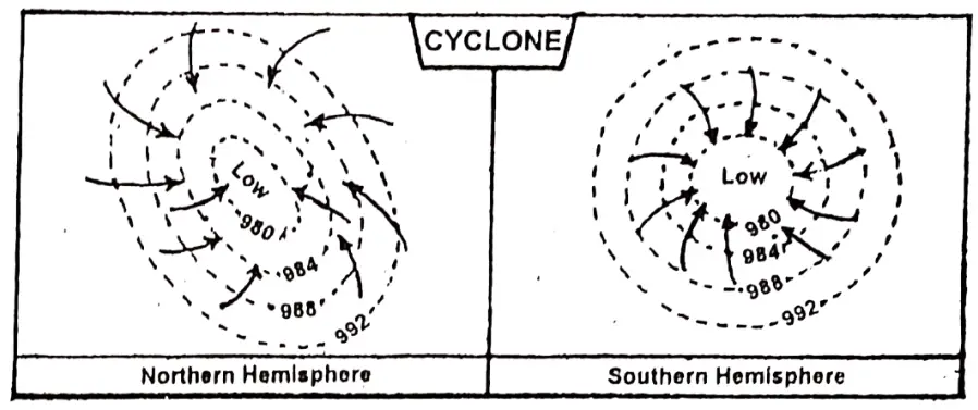
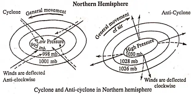
Cyclones: When the stormy whirlwind comes is spirally moving in towards a low pressure centre, it is some of the characteristics of the cyclone,
- Cyclone develops due to the formation of an intense low-pressure centre.
- A cyclone has a low pressure at the centre and high pressure on the surrounding sides.
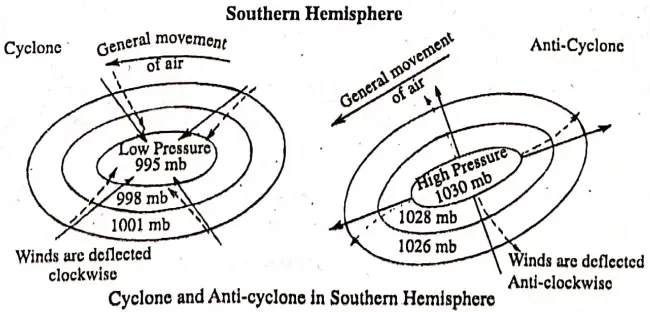
- The wind movement in a cyclone is anti-clockwise in the northern hemisphere and clockwise in the southern hemisphere.
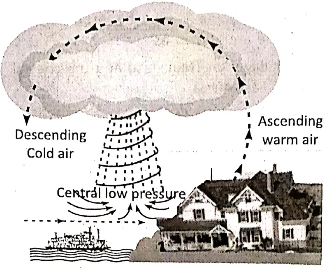
- It blows towards the centre of low pressure from all sides,
- On reaching the centre of low pressure it moves upwards. short time.
- In the structure of a cyclone, isobars from an oval or circular shape.
- Rain falls at the centre of the cyclone.
Classification of Cyclones: Cyclones are divided into two types according to their formation and difference in their location.
- Cyclones formed in the Tropical zone are called ‘Tropical Cyclones’ and
- In the Temperate zone, the ‘Temperate Cyclones’.
Tropical Cyclone: Tropical cyclones are developed in the western margins of ocean and seas in the tropical region between 8° and 20* north and south latitudes.
The cyclones of the Tropics are thermal In origin and develop due to the local convection currents acquiring a whirling motion on account of the rotation of the earth. These develop at special seasons over the sea within the Tropics. The conditions most suited to their origin and development are
- Quiet air
- Highly saturated atmosphere and
- Great heat.
The following are some of the characteristics to the track of a tropical cyclone:
- Between the Equator and 15° latitude, these storms turn towards the west with the trades.
- Between 15° and 30° latitude the path is very uncertain. But these travel towards the north in the northern hemisphere and towards the south in the southern hemisphere.
- As these cross 30° latitude they turn towards the east and their terrific energy declines.
- tropical cyclones are usually small in size and they have a diameter of 100 to 500 km.
- These strong winds exceeding 100 or 150 km/hour are common. Sometimes the velocity increases to 250 or 300 km/hour.
- The centre of this cyclone has the lowest air pressure and it is called the ‘Eye of the cyclone’.
- They are violent and very much destructive in nature. These cause heavy floods and huge destruction of life and property. Trees are uprooted, houses collapse, rail lines, roads and telecommunication lines are disrupted, the coastal parts are submerged.
- Tropical cyclones are associated with dark cumulonimbus clouds and torrential rain accompanied by thunders and lightning.
Parts of the East coast in India are badly affected by tropical cyclones in every year during late summer or autumn.
“WBBSE Class 8 Geography Chapter 4, Pressure Belts and Winds summary”
The chief areas of activity for tropical cyclones are the following:
- West Indies and the coast of Florida. In that region, these are known as ‘Hurricanes’.
- Philippine Islands, the coasts of China and Japan. These are known as ‘Typhoons’.
- Bay of Bengal and the Arabian Sea, where these are known as ‘cyclones’.
- Madagascar (Malagasy) and the coastal regions of East Africa.
- North-east and North-western coasts of Australia.
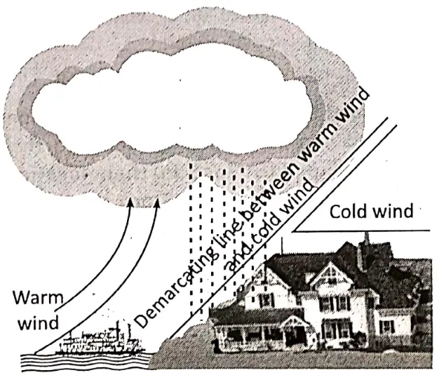
Temperate cyclones: Temperate cyclones are common in the sub-polar low-pressure belt. They are found in the temperate region between 35 and 65 latitudes. These are most dominant over the North Atlantic Ocean and especially during the winter season. These cyclones are frontal in origin. They develop due to the meeting of warm tropical and cold polar airmass.
Characteristics Of Temperature Cyclones:
- These Temperate cyclones are of frontal origin. There are six stages in the development of a temperate cyclone.
- Temperate cyclones are much larger in size than of tropical cyclone and these have a diameter of 1000 to 2000 km.
These are oval-shaped. - Wind velocity is comparatively moderate and in average it ranges between 30 and 50 km/hour.
- These mostly originate in winter.
- These are weaker than tropical cyclones.
- Temperate cyclones are less destructive and less violent.
- They bring rain and cloudy weather and last for a long period.
In India, temperate cyclones are experienced during January and February. They originate in the Mediterranean region and approach north-western part of India through Iraq, Iran and Pakistan. Punjab, Haryana, Uttar Pradesh and Uttarakhand receive rainfall and Jammu and Kashmir and Himachal Pradesh receive snowfall from these cyclones or depressions. The rainfall received in northwest India by temperate cyclones is very beneficial for the rabi crops.
“WBBSE Class 8 Geography Chapter 4 Pressure Belts and Winds, definitions and examples”
Pressure Belts And Planetary Winds
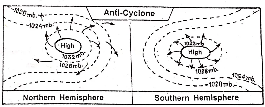
Anticyclones: An anticyclone is just the reverse of a cyclone. It is a wind blowing spirally outward from a high pressure centre. The general characteristics of an anti-cyclone and its structures are as follows:
- An anti-cyclone lies between two cyclones and it has no definite direction,
- The isobars are far apart more especially towards the centre. Variations of temperatures are also noticed.
- The winds are light and slow. They never grow violent and at the centre there is calm with variable winds. Anticyclones at Northern and Southern hemisphere.
- Often cold and heat waves accompany the anti-cyclones.
- Within an anti-cyclone there are local rains,
- It is extensive and its velocity ranges from 30 to 45 km/ hour.
- Winds in an anti-cyclone circulate in clockwise direction in the northern hemisphere. While it is anti-clockwise in the southern hemisphere.
- Anti-cyclonic conditions present calm and clear weather with sunny conditions.
Difference between Cyclones and Anti-cyclones:
| Cyclones | Anti-cyclones |
| (1) Cyclone has low pressure at the centre. | (1) Anti-cyclone has high pressure at the centre. |
| (2) It blows toward; the centre of low pressure from all sides. | (2) It blows in all directions from the centre. |
| (3)In the northern hemisphere it moves anti-clockwise, and in the southern hemisphere, it clockwise. | (3)In the northern hemisphere it blows clockwise, and in the southern hemisphere, it is anti-clockwise. |
| (4) On reaching the centre of low pressure it moves upwards. | (4)It moves downwards. |
| (5) It is strong and lasts for a short time. | (5)It Is not very strong and generally continues for a long time. |
| (6) Bain falls at the centre of cyclones. | (6)It does not produce rain, rather, it brings fair weather. |
| (7) Winds arc warm and ascending. | (7)Winds arc cold and descending. |
| (8)l here present rough and cloudy weather accompanied by thunder, lightning and heavy rain or snow. | (8)Antl-cyclonic conditions present calm and dear weather with sunny conditions. |
WBBSE Notes For 8 Class Middle School Geography
- Chapter 1 Interior Of The Earth Notes
- Chapter 2 Unstable Earth Notes
- Chapter 3 Rocks Notes
- Chapter 5 Cloud And Rain Notes
- Chapter 6 Climatic Regions Notes
- Chapter 7 Human Activities And Environmental Degradation Notes
- Chapter 8 Some Neighbouring Countries Of India Notes
- Chapter 9 North America Notes
- Chapter 10 South America Notes
- Chapter 11 Oceania Notes