Geography Class 10 West Bengal Board Chapter 1 Exogenic Processes And Resultant Landforms True Or False Type:
Question 1. Cusec is the unit used for measuring river velocity.
Answer: False
Question 2. A floating ice mass in the sea is called an iceberg.
Answer: True
Question 3. The confluence of the Alakananda and Bhagirathi rivers is at Devprayag.
Answer: True
Question 4. The altitude of the snowline varies with latitude.
Answer: True
Question 5. Potholes are formed at the base of the waterfall.
Answer: False
Read and learn all WBBSE Solutions For Class 10 Geography And Environment
Question 6. Seif dunes are transformed from Barkhan dunes.
Answer: True
Question 7. Most of the deserts in the world lie on the western parts of the continents where trade winds blow offshore.
Answer: True
Question 8. One of the conditions of delta formation is that there should be large lakes in the river course.
Answer: False
Question 9. Outwash plains present glacial-fluvial landforms.
Answer: True
Question 10. Small streams and rivulets that join the mainstream are called distributaries.
Answer: False
Question 11. The uplands which divide the channels are known as water divides or watersheds.
Answer: True
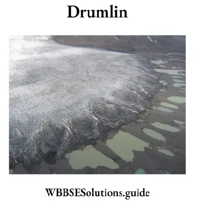
Question 12. Drumlins are low elongated hills formed by glacial deposition.
Answer: True
Question 13. A series of cracks that develop on the surface of a glacier is known as Crevasses.
Answer: True
Question 14. Outwash plains are formed by glacial deposition.
Answer: True
Question 15. The mobile dunes of Rajasthan are called Dhrians.
Answer: True
Question 16. The Ganga-Brahmaputra delta is the largest delta in the world.
Answer: True
Question 17. The ‘New Moore island’ is suspected to have submerged again.
Answer: True
Question 18. Overgrazing does not cause desertification.
Answer: False
Question 19. Deltas occur in the upper course of a river.
Answer: False
Question 20. Plucking is an important action of wind erosion.
Answer: False
Question 21. The largest Indian glacier is Siachen on the Karakoram.
Answer: True
Question 22. The mobile dunes of Rajasthan are known as Dorians.
Answer: True
Question 23. Flood plains are found in Glacial Region.
Answer: True
Question 24. Levees are common in river valleys.
Answer: True
Question 25. Deltas are found at the mouth of the rivers.
Answer: True
Question 26. Drumlins are common in the lower course of Glacier.
Answer: True
Question 27. Barkhan is common in the Desert Region.
Answer: True
Question 28. Zemu isa glacierof the Eastern Himalaya.
Answer: True
Question 29. Moraines are common in Glacial Valley.
Answer: True
Question 30. Pyramidal peaks are common in the Desert Region.
Answer: False
Question 31. One of the salient features of a river in its upper course is pothole.
Answer: True
Question 32. The landforms either carved out or build up by running water are called alluvial landforms.
Answer: True
Question 33. Abrasion is the mechanical wear and tear of the erosional tables in themselves.
Answer: False
Question 34. Canyons and gorges represent very deep and narrow valleys.
Answer: True
Question 35. Rapids are of much wider dimension than waterfalls.
Answer: False
Question 36. The narrow flat surface on either side of the valley floor are called the river terrace.
Answer: True
Question 37. The side cutting of a river is mostly found in upper course.
Answer: True
Geography Class 10 West Bengal Board
Question 38. An ideal river has three courses.
Answer: True
Question 39. The highest waterfall in the world is the Niagra.
Answer: False
Question 40. Flood plains are found in glaciated regions.
Answer: False
Question 41. The course from the source to its mouth is the basin of the river.
Answer: True
Question 42. Hanging Valley is common in a glacial valley.
Answer: True
Question 43. Cirques are common in mountain areas.
Answer: True
Question 44. Snowline is the height above which the snow never melts.
Answer: True
Question 45. The snow line does not vary due to latitude and the nature of slope.
Answer: False
Question 46. A glacier is a large mass of moving ice.
Answer: True
Question 47. Levees are common in river valleys.
Answer: True
Question 48. The action of the wind is dominant in humid regions.
Answer: False
Question 49. A large depression formed by deflation is called a blowout.
Answer: True
Question 50. Steep sides overhanging ridges of hard rocks are called Yardangs.
Answer: True
Question 51. Zeugens are formed when soft rocks lie under a layer of hard rocks.
Answer: True
Question 52. Inselbergs are mostly found in the Sahara desert.
Answer: False
Question 53. Mushroom rocks are formed in desert areas.
Answer: True
Question 54. The rocks with hanging broad upper parts and narrow bases resembling an umbrella are called Mushrooms.
Answer: True
Geography Class 10 West Bengal Board
Question 55. The lakes formed in deserts are known as Playas.
Answer: True
Question 56. The rocky desert is called Ery.
Answer: False
Question 57. Barkhan is a longitudinal dune.
Answer: False
Question 58. The rivers move swiftly and create round holes by corrasion on the river bed called deflation hollows.
Answer: False
Question 59. The knife-like sharp serrated ridge between two corries is called an Arete.
Answer: True
WBBSE Class 10 Geography Solutions Chapter 1 Exogenic Processes And Resultant Landforms Fill In The Blanks Type:
Question 1. The Nile delta is ______ shaped.
Answer: Arcuate
Question 2. The highland between two adjacent corries is called ______.
Answer: Arate
Question 3. The process of modifying landforms by the combined action of erosion and weathering is called _____.
Answer: Denotation.
Question 4. Holes formed by abrasion on river bed are called _______.
Answer: Pothole.
Geography Class 10 West Bengal Board
Question 5. After the name of ______ river, the zigzag course of a river is known as a meander.
Answer: Menderes.
Question 6. Horizontal and parallel cracks or fractures found on the surface of a glacier are called ______.
Answer: Crevasse.
Question 7. The plantation of landmass caused by different exogenic forces is called ______.
Answer: Graduation.
Question 8. Long, narrow, winding, steep-sided ridges formed by the fluvioglacial deposits of sands and gravels is called ______.
Answer: Esker.
Question 9. Sundarban is located on the delta of the three rivers _______,______ and ______.
Answer: Ganga, Brahmaputra and Meghna.
Question 10. ______ are low elongated hills formed by glacial deposition.
Answer: Drumlins.
Question 11. _______ or rock pedestal is produced by wind erosion.
Answer: Gour.
Question 12. The hard stony ribs of ridge and furrow topography formed due to wind erosion (on vertical bands of hard and soft rocks) are called ______.
Answer: Yardangs.
Question 13. The steep-sided deep valley produced by a river is called ______.
Answer: V-shaped valley.
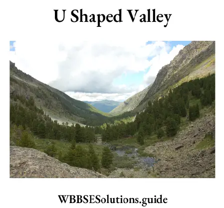
Question 14. U-shaped valley is produced by the erosive action of ______.
Answer: Glacier.
Question 15. ______ are typical cresent-shaped sand dunes.
Answer: Barkhans.
Question 16. Flood plains are found in the _______ course of a river.
Answer: Lower.
Question 17. ______ is an agent of Gradation.
Answer: River.
Question 18. ‘U’-shaped valley is common is the ______ region.
Answer: Glacial.
Question 19. ‘V’-shaped valley is common in the ________.
Answer: River Basin.
Question 20. Deltas are the creation of a ________.
Answer: River.
Question 21. _______ are common in the limestone region.
Answer: Stalactites.
WBBSE Class 10 Geography Solutions
Question 22. Fossils are found in the _______.
Answer: Sedimentary Rock.
Question 23. The largest Glacier of India is _______.
Answer: Siachen.
Question 24. ________ is the largest Piedmont Glacier.
Answer: Malaspina.
Question 25. _______ is the main work of a river in the upper course.
Answer: Erosion.
Question 26. The naturally formed raised banks of a river are called _______.
Answer: Natural Levees.
Chapter 1 Exogenic Processes And Resultant Landforms Very Short Answer Type Questions:
Question 1. Which bank of a river meander experiences more erosion?
Answer: Concave slope / Outer bend
Question 2. At which altitude, the snow line is found in polar region?
Answer: sea level / 0 meter
Question 3. Name the sand dunes formed parallel to the wind direction.
Answer: Self-dunes / longitudinal dunes
Question 4. Name the largest valley glacier of the world.
Answer: Hubbard (122 km.)
WBBSE Class 10 Geography Solutions
Question 5. What is the name of the Sandy desert in the Sahara?
Answer: Ergs.
Question 6. From where the word ‘meander’ has been derived?
Answer: The word ‘meander’ is derived from the name of a small winding river ‘Meanders’ in Turkey.
Question 7. Which activity out of erosion and. deposition by river increases due to rejuvenation?
Answer: Erosion.
Question 8. In which stage does the incident river capture take place?
Answer: N.M. Davis.
Question 9. Give a single term for each of the following:
1. A stream that gets divided into a network of interconnected channels.
Answer: Braided Stream.
2. Raised banks of natural embankments built up of coarse deposits along the river channel.
Answer: Natural Levees.
3. Winding sections or loops of a stream.
Answer: River Meander and Oxbow lake.
4. A higher ground separating two adjoining drainage basins.
Answer: Water Divide.
5. A drainage pattern looking like the trunk and branches of a tree.
Answer: Dendritic pattern.
Question 10. Who put forward the idea of the ‘cycle of erosion’?
Answer: W.M. Davis.
Question 11. What are the three stages of the cycle of erosion?
Answer: Youth, maturity and old age.
WBBSE Class 10 Geography Solutions
Question 12. What is the deep vertical crack which opens up at the head of the glacier called?
Answer: Bergschrund.
Question 13. Name the typical crescent-shaped sand dunes in a desert.
Answer: Barkhans.
Question 14. What is the other word used to indicate the expansion of deserts?
Answer: Desertification.
Question 15. What is the shape of a glacial valley?
Answer: U-Shaped.
Question 16. What is Snout?
Answer: The glacier’s downstream end is known as the snout.
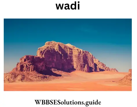
Question 17. What is Wadi?
Answer: The river valley created by the erosive action of rainwater due to sudden torrential showers in desert areas is called ‘Wadi1.
Question 18. What is Pediment?
Answer: The highly eroded plain formed at the foot of the mountain due to erosive actions of both wind and running water in deserts is called ‘Pediment’.
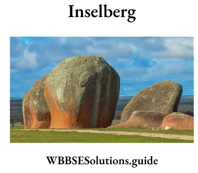
Question 19. Who coined the term ‘Inselberg’?
Answer: S. Passage, a German geomorphologist.
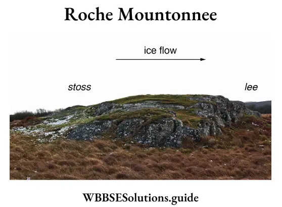
Question 20. Who coined the term ‘Roche Moutonnee’?
Answer: De Saussure in 1804.
Question 21. What is a wind gap?
Answer: The weak place between the elbow of capture and the upper portion of the cutted river is called the ‘wind gap’.
Question 22. What is the ‘sixth power law’?
Answer: ‘Gilbert’ propounded his famous ‘sixth power law’, which states that rate of the discharge of water is directly proportional to the velocity of the river.
Question 23. In which regions sand dunes are found?
Answer: In the Desert Region and in the Coastal Region sand dunes are found.
WBBSE Class 10 Geography Solutions
Question 24. Name the largest valley glacier of India.
Answer: Siachen.
Question 25. Name the largest Piedmont glacier in the world.
Answer: Malaspina in Alaska (U.S.A).
Question 26. Name the local names of the sand dunes of the Malabar coast (Kerala).
Answer: Teries.
Question 27. Name the local name of the lagoons in the Malabar coast.
Answer: Kayal.
Question 28. Name the glacier of the Eastern Himalayas.
Answer: Zemu glacier.
Question 29. Which is the largest desert of the world?
Answer: Sahara desert in North Africa.
Question 30. Name the desert of India.
Answer: The Thar desert.
Question 31. In which continents are the Atacama and Kalahari deserts located?
Answer: Atacama in South America and Kalahari in Africa.
Question 32. What is the name given to the sandy desert in the Sahara?
Answer: Erg.
Question 33. What name is given to the stony desert in Algeria?
Answer: Reg.
Question 34. What is Hammada?
Answer: Hammada is the name given to the rocky desert of the Sahara.
Question 35. What is the other name of mushroom rock?
Answer: Gaur or Gara or Pedestal rock.
Question 36. Name the area of the largest loess deserts.
Answer: North China.
Question 37. Name two important features formed by the depositional work of the wind.
Answer: Sand dunes and loess.
WBBSE Class 10 Geography Solutions
Question 38. Define a glacier.
Answer: A glacier is a mass of snow and ice that moves slowly over the land away from the place of accumulation.
Question 39. Who proved that glaciers are not static but they move forward?
Answer: Louis Agassiz.
Question 40. What is the significance of snowlines?
Answer: Snow never melts above the snowline. A huge mass of snow above the snowline gives birth to glaciers.
Question 41. Name the biggest continental ice sheet of the world.
Answer: Antarctica.
Question 42. What is Playa?
Answer: The small salt lakes present in desert regions are called playa.
Question 43. Name the largest canyon of the world.
Answer: Grand Canyon of river Colorado in the U.S.A.
Question 44. Which is the largest delta of the world?
Answer: The Ganga-Brahmaputra Delta in India.
Question 45. What will be the transport competence of a river if its velocity is doubled?
Answer: 64 times. [The transport competence is proportional to the sixth power of the velocity of the stream.]
Class 10 Geography Chapter 1 West Bengal Board Chapter 1 Exogenic Processes And Resultant Landforms 2 Marks Questions And Answers:
Question 1. Define “Graduation”.
Answer:
“Graduation”:
Gradation is the process of levelling of the land by natural agents like rivers, groundwater, winds, glaciers, and sea waves. The processes in gradation are erosion, transportation, and deposition.
Question 2. What is an alluvial cone?
Answer:
Alluvial cone:
As the river comes suddenly from its upper course to its middle course, its velocity decreases and its sediments are deposited along with the flow of the river resembling the shape of a cone or fan. This is known as the Alluvial cone.
Question 3. What do you mean by “piedmont glacier”?
Answer:
Piedmont glacier:
In temperate regions, the snow line descends quite low. Here small glaciers descend at the foot of the mountains and start meeting with each other. It is called the piedmont glacier.
Question 4. Define “transverse dune”
Answer:
Transverse dune
A large, strongly asymmetrical, elongated dune lying at right angles to the prevailing wind direction. Transverse dunes have a gently sloping windward side and a steeply sloping leeward side. They generally form in areas of sparse vegetation and abundant sand.
Question 5. What do you mean by”Maidan”?
Answer:
Maidan:
A wide flat land area whose height is generally low. Generally, flat and wide areas up to 150 meters above sea level are called plains.
Class 10 Geography Chapter 1 West Bengal Board
Question 6. What is “Rann of Kutch”?
Answer:
“Rann of Kutch”
The Rann of Kutch is a salt marsh located in the Thar Desert in the Kutch District of Gujarat. Also referred to as the White Desert, it is about 30,000 sq. km. in size and is reputed to be one of the largest salt deserts in the world.
Question 7. What is Bergschrund?
Answer:
Bergschrund: A bergschrund is a long narrow crack developed at the source of the glacier. This is created when the mass of ice tends to flow down due to gravity and the mountain’s walls tend to hold back the ice due to friction.
Question 8. What is Canyon?
Answer:
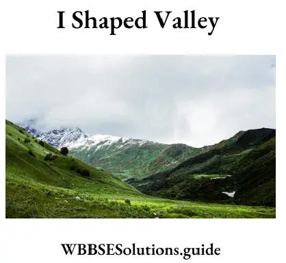
Canyon: The valley formed by the river in its upper course in which vertical erosion is much greater than lateral erosion is known as an l-shaped valley as it resembles the English alphabet ‘I’. This valley is very narrow and very deep. It is also called Canyon.
Question 9. What do you mean by “Inselberg”?
Answer:
Inselberg:
Inselberg is a small, rounded hill, knob, ridge, or mini-mountain that rises abruptly from relatively flat surroundings. It is also called a monadnock.
Question 10. What is Plunge Pool?
Answer:
Plunge Pool:
In mountainous regions, waterfalls are created where the river drops from a considerable height with great velocity. Small depressions or hollows known as potholes are created at the base of the waterfalls due to the pounding of rock fragments brought down by the water. These potholes gradually grow bigger in size to form Plunge Pools.
Question 11. Define Loess.
Answer:
Loess:
Loess, an unstratified, geologically recent deposit of silty or loamy material that is usually buff or yellowish brown in colour and is chiefly deposited by the wind. Loess is a sedimentary deposit composed largely of silt-size grains that are loosely cemented by calcium carbonate.
Question 12. What is denudation?
Answer:
Denudation
Denudation involves the processes of weathering, erosion and transportation together. It is a term derived from the Latin word ‘denudate’ meaning ‘to strip bare’. It, therefore, causes the removal of rock layers from the earth’s surface resulting in the lowering of the land surface.
Question 13. How are the “deflation hollows” formed?
Answer:
Formation deflation hollows
‘Deflation hollows’ or deflation basins are formed by sweeping away of loose, light and dry sand particles by wind. They are also known as ‘desert hollows’ or ‘blow-outs’.
Class 10 Geography Chapter 1 West Bengal Board
Question 14. What is Iceberg?
Answer:
Iceberg: Huge blocks of ice that break off from glaciers and fall into the sea are called icebergs.
Question 15. How are the bird’s foot deltas formed?
Answer:
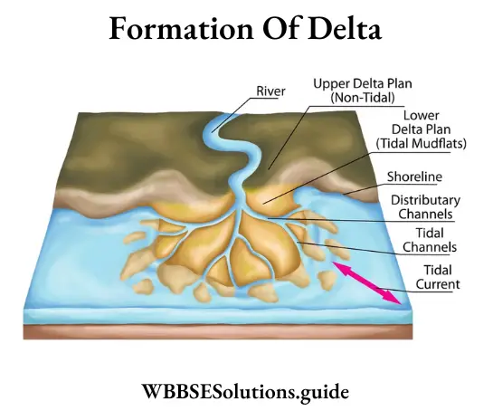
The deltas that look like a bird’s claw or fingers spreading one beside the other, are called bird’s foot deltas. Eg. Delta of the river Mississippi in North America.
Question 16. What is an estuary? What geographical conditions are needed for its formation?
Answer:
Estuary
Some rivers have strong tidal currents at their mouths and so the materials brought down by these rivers to their mouths are carried far into the sea. Deposition of materials at the mouth is almost impossible. The mouths of such rivers are very wide. The wide mouths of tidal rivers are known as estuaries. The mouth of the Thames is a typical estuary.
Question 17. What are the different types of deltas?
Answer:
Three types of deltas are usually distinguished:
1. Arcuate or fan-shaped, e.g. Nile.
2. Cuspate or pointed like a tooth, e.g. Ebro.
3. Birds-foot type with fingering branches, e.g. Mississippi.
Question 18. What part does water play to modify a desert landscape?
Answer: In a desert torrential short-lived rainstorms cause sheet floods on level ground and flash floods down slopes and channels. Such occasional floods are disastrous.
Water action produces:
1. Wadis: large dry channels,
2. Bajadas: piedmont alluvial plain produced by the merger of a number of alluvial fans, and
3. Playas, Salinas, Dhand’s, and Bolsons: all different names for salt lakes.
Class 10 Geography Chapter 1 West Bengal Board
Question 19. How do we identify a river’s realm or domain? What is a divide or watershed?
Answer:
The land drained by a river, a natural drain, is the river basin; the area which supplies water is its catchment. Basin is a part of the catchment, and the two together constitute the domain of the realm of a river. A divide or watershed is the edge that divides two river basins.
Question 20. Distinguish between a bed and a valley.
Answer:
Dfference between a bed and a valley
A river flows in its bed which lies at the bottom of a curb called a valley. Although a river down cuts to form a valley floor, the shape of the valley sides is determined by mass wasting, which widens the narrow-cut bed made by the river.
Question 21. What is a basket of egg topography?
Answer:
Basket of egg topography: When the Glacier faces an obstruction in its path, its load is more than it can carry, it dumps its load. These mounds taper two ends along the flow of the glacier, resembling upturned boats or eggs, as they are high at the centre, elongated and pointed at two ends. These are called Drumlins. Many drumlins deposited widely are also called “Basket of Eggs” topography.
Question 22. What is a glacier?
Answer:
Glacier:
The term glacier is derived from the French word ‘Glace’, meaning ice. A huge mass of ice compressed and formed by the consolidation under the pressure of snow that moves slowly over land is called glacier.
Question 23. here is the source of the river Yamuna.
Answer:
Yamuna originates from the Yamunotri glacier situated at the West of Gangotri (Uttranchal).
Question 24. What is a flood plain?
Answer:
Flood plain
Floodplain All great rivers have wide-level lands adjacent to their banks over which they spill their waters in times of flood and deposit alluvium. Such low-lying alluvial plains built by rivers mainly during high water are called flood plains.
Example: Flood plains of the Ganga and Brahmaputra.
Question 25. What are the works of a river?
Answer:
There are three works of a river
1. Erosion (in upper or mountain course),
2. Transportation (in the middle or plain course),
3. Deposition (in lower or delta course).
Class 10 Geography Chapter 1 West Bengal Board
Question 26. Where are alluvial cones formed?
Answer:
Alluvial cones are formed at the foothills of mountains where the river suddenly changes its slope from steep to gentle. Its velocity also suddenly decreases. So, the river’s carrying capacity suddenly drops & it deposits pebbles & other coarse materials at the junction of the mountain & plain. The shape of the deposition is like fan or cone, so it is called an alluvial fan or cone. They are found abundantly in the Terai region of the Himalayas.
Question 27. Name three features produced by wind erosion.
Answer:
Features produced by wind erosion are
1. Inselberg,
2. Ventifact,
3. Gour.
Question 28. What is Dhand? Where it is found?
Answer:
Dhand
Deflation is a process of wind erosion occurring in desert regions. The high speed of wind lifts sand from one region & carries it. Thus, by the lifting of sand many big & small depressions formed. The small depression produced by deflation is called Dhand. It is found in the Rajasthan desert of India.
Question 29. What is Kame?
Answer:
Kame
At the end of a glacier when among the terminal moraines, snow meltwaters cause the various stones, rocks, pebbles & clay, etc. to form a mould-shaped deposition with three-sided angular, is called Kame.
Question 30. Why is the river Ganga called an ideal river?
Answer:
River Ganga is called an ideal river because it clearly shows three courses,
1. Youthful or upper course,
2. Maturity or middle course and
3. Old or lower course.
Question 31. What is the discharge of a river?
Answer:
Discharge of a river
The discharge of a river is the combination of the volume and velocity of the river. It is measured in cusec (a cubic foot of water passing through the river at a point per second).
Question 32. Name two rivers of India which form an estuary.
Answer:
The Narmada &Tapti rivers of India form an estuary.
Class 10 Geography Chapter 1 West Bengal Board
Question 33. What are rapids & cascades?
Answer:
Rapids & cascades
When waterfalls have less steep slopes, they are called rapids. So, we may call them small waterfalls. It is found in the hilly regions of the Chhotanagpur plateau. When waterfalls flow down in many steps or in many channels or branches, they are called cascades.
Question 34. Give an example of a mountain glacier.
Answer
: Zemu glacier (26 km in length) in the Karakoram mountain range is an example of a mountain glacier.
Question 35. What is Cirque?
Answer:
Cirque:
Cirque is a basin (looks like a handle of a deck chair) cut into the side of a mountain by glacial erosion at the head of a glaciated valley.
Question 36. What is Hanging Valley?
Answer:
Hanging Valley:
The hanging valley is a valley of tributary glaciers located high above the valley of the main glacier. The streams in the hanging valley descend to the main valley as a waterfall.
Question 37. What is Roche moutonnee?
Answer:
Roche moutonnee:
Roche moutonnee is a rock mound modified by glacial erosion. Its upstream surface is gently sloping & smooth while its downstream surface is steep & rough.
Question 38. Which is the largest glacier of the world?
Answer:
Beardmore (160 km in length) which is the Antarctic continental glacier is considered the largest glacier in the world.
Question 39. Where is the world’s only equatorial glacier?
Answer:
Mt. Cotopaxi in Equador supports the only glacier on the equator.
Question 40. What is a river?
‘Answer:
River:
According to Jackie Smith, “A river is a large stream of fresh water flowing down from the hills within a channel to enter or a lake or sea”.
Question 41. What is a river basin?
Answer:
Rver basin:
The principal river with its tributaries and distributaries drains a vast area. It looks like a basin. The area which is drained by a river and its tributaries and distributaries is called a river basin. The Ganga Basin is the largest river basin in India. The Amazon Basin of South America is the largest river basin of the world.
Question 42. What is water partings?
Answer:
Water partings
The highlands between the two adjacent river basins, which forms a natural boundary between the adjacent river basins, is called watershed or water partings.
Question 43. What are Interfluves?
Answer:
Interfluves:
The highlands separating one river valley from the next are called Interfluves.
Question 44. What are tributaries?
Answer:
Tributaries:
Tributaries are the smaller rivers that join the main river carrying the water from its surrounding.
Question 45. What are distributaries?
Answer:
Distributaries:
Distributaries are the branches or outlets which leave the main river carrying its water to the sea or lake.
Question 46. How far does the mountainous course of the river Ganga extend?
Answer:
The mountainous course of the river Ganga extends from the icy cave of Gomukh on the Himalayas to the foothills at Haridwar.
Class 10 Geography Chapter 1 West Bengal Board
Question 47. In which part of the course of a river depositional activity is most prominent?
Answer:
The depositional activity of a river is most prominent in the lower course.
Question 48. What is Dhrian?
Answer:
Dhrian:
The mobile sand dune of Rajasthan is known as Dhrian.
Question 49. What is the shape of the valley carved out by a glacier?
Answer:
The shape of the valley carved out by a glacier is U-like, i.e., U-shaped.
Question 50. In which regions sand dunes are found?
Answer:
Sand dunes are found in deserts (Arabian deserts, Rajasthan deserts) and coastal areas of seas and oceans.
Question 51. What is Espers?
Answer:
Espers:
The long ridge of material deposited parallel to the direction of flow of the meltwater is called espers.
Question 52. What are kettle lakes?
Answer:
Kettle lakes
The melted water from glaciers may get accumulated in holes or depressions created in the outwash plains due to the melting of a detached mass of ice that might have been left partly or wholly buried. These are called kettle lakes.
Question 53. What is salt weathering?
Answer:
Salt weathering
Salt crystallisation causes the disintegration of rocks when saline solution seeps into cracks and joints in the rocks and evaporates, leaving salt crystals behind. These salt crystals expand as they are heated up, exerting pressure on the confining rock. This is known as salt weathering.
Question 54. What is Stone Lattice?
Answer:
Stone Lattice:
When a rock with parallel series of hard and soft strata of an area is arranged both in horizontal as well as in vertical directions, a Stone Lattice is formed.
Question 55. What is Demoiselle?
Answer:
Demoiselle
There are many areas which are made of hard rocks. Winds subject the upper parts of the rocks to abrasion but the lower parts remain protected. The protected soft rock stands like a pillar below the hard rock and is known as Demoiselle or Earth Pillars.
Question 56. What do you mean by Col or Pass?
Answer:
Col or Pass: When two cirques from opposite sides of a hill develop and meet each other, a col or a pass is formed. Many passes in the Alps were formed by glacial action. Some of the world’s passes are used for transportation.
Class 10 Geography Chapter 1 West Bengal Board
Question 57. What is Fjord?
Answer:
Fjord: Fjord is a long narrow inlet with steep sides or cliffs, created by glacial erosion. It is generally formed when a glacier cuts a U-shaped valley by ice segregation and abrasion of bedrock. Most fjords are deeper than the adjacent seas. There are many fjords on the coast of Norway, Alaska, Iceland, etc.
Question 58. Differentiate between the valley shapes formed by the river and the glacier.
Answer:
The valley shape formed by the river is V-shaped, while the valley developed by the glacier is of U-shape.
Question 59. Name two important deltas in India.
Answer:
Important deltas in India
1. The Ganga and the Brahmaputra have the most extensive delta,
2. The Delta of the Mahanadi.
Question 60. What is deflation hollow?
Answer:
Deflation hollow:
A deflation hollow is a vast depression on the sandy desert developed by the deflation action of wind erosion, i.e., by lifting and blowing away of sands from the ground.
Example: The Qattara Depression in Egypt.
Question 61. What is a pyramidal peak?
Answer:
Pyramidal peak
When several cirques are developed on all sides of a mountain, a horn-shaped pyramid is formed by the glacial action and is known as the pyramidal peak.
Example: Neelkanth peak on the Himalayas.
Geography Class 10 Solutions WBBSE Chapter 1 Exogenic Processes And Resultant Landforms Short Notes:
Question 1. Sand bars.
Answer:
Sand bars:
While carrying a lot of sand, deposits, the path of wind is obstructed by vegetation, large rock pieces, bushes, etc. The wind dumps a part of its load where it is obstructed to form a mound of sand which is called sand. bars.
Question 2. Zeugen.
Answer:
Zeugen:
When the wind blows steadily in one direction for a considerable time, due to differential abrasion, the wind wears away the underlying softer rock through the joints (caused by mechanical weathering). The harder rock layer stands uneroded like a ridge. This is known as Zeugen. They are of varying heights (from 1.5 m to 45 m).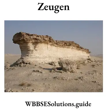
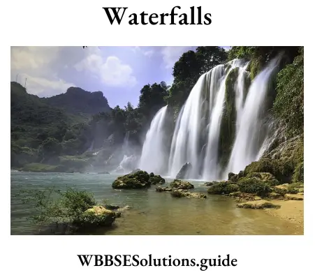
Question 3. Waterfalls.
Answer:
Waterfalls”
When a river falls suddenly from a certain height along a vertical slope, it is known as a waterfall. Waterfalls are formed in mountainous regions, when
1. Water falls over a softer rock horizontally, soft rocks are eroded away rapidly; and
2. A hard rock bed lies vertically across a river. Niagara Falls in North America is a famous waterfall of the world. In India, the Narmada Falls at Jabalpur on marble rock presents a beauty scene. Victoria Falls in Africa has a name and fame.
Geography Class 10 Solutions WBBSE
Question 4. Alluvial fan.
Answer:
Alluvial cone or fan: As the river suddenly changes its slope from steep to gentle, its velocity decreases. Thus, the river’s carrying capacity also decreases and the loads are deposited at the juncture of the mountain with the plain. The sand, pebbles, etc. that are deposited, increase in width along the flow of the river, giving it a cone of fan-shape of alluvial deposit. This is called the alluvial cone or fan. At Haridwar along the river, Gange’s alluvial fans can be seen.

Question 5. Gour or Rock pedestal.
Answer:
Gour or Rock pedestal:
The rocks having broad upper parts and narrow bases resembling an umbrella or mushroom are called mushroom rocks or pedestal rocks. These are formed due to the abrasive works of wind. The base of the individual rock block is abraded vigorously from all sides because of variable wind directions. Active abrasion is limited to six feet height from the ground while the upper part is least affected by abrasion. These are also called “Gara” in Sahara.
Question 6. Delta.
Answer:
Delta:
Largest deposits of materials take place at the mouth of a river. The deposits are so vast that the flow of the river is obstructed and the river course turns in many branches and between each couple of branches, a fan-shaped alluvial land is formed. This land resembles the Greek alphabet (A)delta, thus, is known as delta. Some deltas are “arcuate” or “bow-shaped” and some are.”bird-foot”. The delta of the Nile is the bird-foot delta. The delta of the Ganga in southern West Bengal is the largest delta of the world.
Geography Class 10 Solutions WBBSE
Question 7. Barkhan.
Answer:
Barkhan:
When the sand-carrying wind blows constantly in a particular direction, the slightest obstruction, like a tuft of grass may cause typical crescent-shaped dunes in sandy deserts. They are known as ‘Barkhans’ or ‘Barchans’. Their windward slope is convex and gentle while their leeward slope is concave and steep. The rate of their movement is nearly one metre per day. They move in the direction of the prevailing wind. They are mostly found in the deserts of Atacama, Sahara, Kalahari and Arabia. These shifting dunes in the Indian desert are called Dhrians.

Question 8. Roche Moutonnee.
Answer:
Roche Moutonnee:
These are hillocks of rock of a glaciated mountain which have been smoothed by the glacier on the upstream side, and left rough and rugged, with steeper slopes on the downstream side. They resemble sheep lying on the hillside and are also called sheep rocks.
Question 9. Natural Levee.
Answer:
Natural Levee:
Along the banks of an old river large deposits of materials take place every year when the river is in flood. This accumulation of materials becomes so much that the bank gets higher and higher after a long period of time. This raised bank is known as a natural levee. Sometimes the flood water is obstructed to flow out by the levees. Natural levees are found in the lower course of the Ganga and the Hwang-Ho rivers.
Geography Class 10 Solutions WBBSE
Question 10. Potholes.
Answer:
Potholes:
Whenever a soft rock comes in the way of the river, it is eroded and scattered all around. Eddies are formed and water whirls around and produces depression by plucking the sediment up. This makes the depression deep and cylindrical. Sometimes these depressions look like discs and are known as potholes. Stone pieces also enter the potholes along with water and act as grinders. The potholes have a diameter varying from a few centimetres to many metres.
The depth of a pothole is greater than its diameter. Potholes of over 7 metres in depth have been observed. When the potholes grow in size they are called plunge pools. It is very difficult to escape once one is caught in a plunge pool. Some people call these potholes and plunge pools as Devil’s Punch Bowl or Witches’ Cauldron because they think that such formations are due to the work of some supernatural power.
Question 11. Glacial Trough.
Answer:
Glacial Trough:
It is formed due to glacial erosion when a long elongated valley is formed as a result of abrasion and depletion of snow in the armchair-like depression of cirque. A glacial trough can also be formed when the wall between two back-to-back cirques breaks, thus forming a long valley.
Question 12. Pediment.
Answer:
Pediment:
In the hot desert area the frontal part of a mountain is broken by the action of wind and the rocks thus left have a moderate slope. No deposition of materials takes place. This is known as a pediment.
Geography Class 10 Solutions WBBSE
Question 13. Corrie and Arete.
Answer:
Corrie and Arete:
Corrie and Arete are the different types of features produced by glacial erosion. In the source regions of glaciers, in high mountain regions, glacial erosion causes a light depression to be eroded in such a way that the mountainside is steepened to form a headwall and at its foot, a pronounced depression is created by erosion. When the glacier melts away in summer, these resemble an armchair-like depression called Corrie in English and Cirque in French.

Whereas, Aretes are formed when glacial erosion may cause adjacent corries to develop in the mountainside. The ridge that forms the boundary between the adjacent depressions is called the Arete.
Question 14. Yardang.
Answer:
Yardang:
Yardangs are one of the various landform features developed out of aeolian erosion in desert regions. When hard and soft rocks are arranged vertically to the earth’s surface, then the soft rocks get quickly eroded forming long valleys while the hard rocks stand out as ridges called Yardang. These are generally 15 metres high and are found in the deserts of Central Asia. Sometimes hard and soft rocks stand parallel to the prevailing winds. Due to abrasion soft rocks are worn away and the hard ones stand as stony ribs. The whole area resembles ‘furrow’ or ‘ridges’. This phenomenon is known as ‘Yardang’. This is common in the Atacama desert.
Geography Class 10 Solutions WBBSE
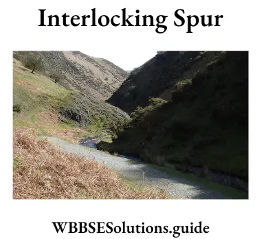
Question 15. Interlocking spur.
Answer:
Interlocking spur:
Interlocking spurs are found in the upper course of a river, in mountain regions hard rocks or rocky ridges obstruct the flow of a river in such a way that the river has to keep on bending to overcome the hard rock obstructions. From afar, these obstructions look like spurs that are interlocking, so they are called interlocking spurs.

Question 16. Hanging valley.
Answer:
Hanging valley:
As the main river has a tributary river, in the same way the main glacier has a tributary glacier. The valley of the main glacier is deeper than that of the tributary glacier. After the melting of snow, the tributary valley seems to be hanging over the main valley. This is called Hanging valley.

Question 17. Drumlin.
Answer:
Drumlin:
In a few areas, due to the depositional work of a glacier, hills of considerable height are found. They are mainly composed of boulder clay and are elongated in the direction of the moving glacier. They look like elongated ‘whale back’ hummocks and are shaped like a half eggs. They are called drumlins. Drumlins are found in Central Ireland, Tweed basin and North-Eastern U.S.A. Drumlins are formed singly or in groups. When they are formed in groups, a “basket of eggs” like landscape is developed, called “Egg Basket Topography”.
Geography Class 10 Solutions WBBSE

Question 18. Lagoon.
Answer:
Lagoon:
On the sea coast due to the action of sea waves and wind, accumulation of sand takes place. The shallow and small stretch of water which is separated from the sea by sand bars is known as a Lagoon. Chilka lake on the coast of Orissa is a good example.
Question 19. Abrasion.
Answer:
Abrasion:
It is one of the three ways by which wind erosion is caused. The wind drives sand dust particles against an exposed rock, thereby scratching, polishing and wearing away the face of the rock. This process is known as ‘abrasion’. It is most effective on the base of the rock when the wind carries big-sized materials in larger quantities.
Question 20.Loess plain.
Answer:
Loess plain:
Fine particles of clay are blown by the wind and are deposited in faraway areas. This is blown due to the action of very swift wind. That is why they are deposited without any layer or strata. The colour of these materials is yellow or light grey. This soil is very fertile. The plain of the Hwang-Ho is made of such soil.
WBBSE Class 10 Geography Solutions
Question 21. Moraine.
Answer:
Moraine:
Moraines are fragments, particularly boulders and coarse materials like sand, clay, and gravel that are brought down with the movement of a glacier. These are of the following types:
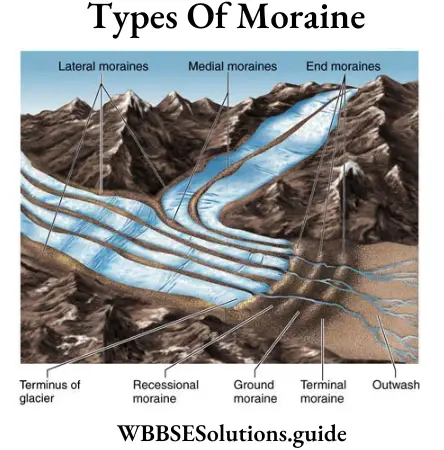
1. Terminal or Marginal Moraine: When the materials brought down by a glacier are dropped at the end of the glacier, a Terminal or End Moraine is formed. Here at this point, the ice is melting.
2. Lateral Moraine: When the materials are deposited along the sides of the moraine, it is known as Lateral Moraine.
3. Medial Moraine: When two glaciers meet, the meeting lateral moraine of each glacier forms an inner moraine below the meeting point. The line of materials is called Medial Moraine.
4. Ground Moraine: The materials deposited beneath the glaciers are called Ground Moraine. It consists of rock materials of all sizes from clay to large boulders and is found scattered.
5. Recessional Moraine: When the accumulation of materials takes place in a terminal or end moraine, and the scattered materials are left behind the terminal moraine the successive moraines produced by successive drifts in ice retreat are called Recessional Moraine.
Question 22. Outwash plains.
Answer:
Outwash plains:
These are smooth sloping plains lying in front of the glacial margin. They are made of fluvioglacial deposits. Such plains are formed by the material washed out by streams and channels of melting water. An outwash plain is best developed just outside the terminal moraines.
Chapter 1 Exogenic Processes And Resultant Landforms 3 Marks Questions And Answers:
Question 1. Discuss in brief about three processes of river transportation activity.
Answer:
Transportation: The work by which the river carries away the eroded materials from one place to another is called transportation, the materials that the river transports are called its load.
Class 10 Geography Chapter 1 WBBSE
There are four methods by which the river transports its load:
1. Solution: The materials like salts are usually dissolved in river water and are carried in solution.
2. Suspension: Sand, silt and mud are carried in suspension as the river flows. The majority of the river’s load (about 70%) is carried in this way.
3. Saltation: By this method, the larger loads jump up and then hit the bed and side of the channel and repeat this process to proceed further.
4. Traction load: The materials like rocks, boulders, pebbles, stones etc., which are too heavy to float are rolled along the river bed as traction (pulled) load.
The work of transportation is prominent in the upper and middle course of the river.
Question 2. State three differences between “Seif dune” and “Barkhan”.
Answer:
Three differences between “Seif dune” and “Barkhan”
| Barkhans | Seif dunes |
| 1. The term Barkhan comes from the Turkish word ‘Barkhan’, meaning sand mountain. | 1. The term Seif comes from the Arabian word ‘Seif’, meaning a straight sword. |
| 2. Formed like a curve diagonal or perpendicular to wind direction. | 2. Formed like straight lines parallel to the wind direction. |
| 3. They are crescent-shaped dunes. The windward side is convex and the leeward side is concave. | 3. They are narrow and straight and look like parallel ridges. |
Question 3. Explain why a delta is formed at the mouth of a river.
Answer:
Formation of Delta: The velocity of the river is almost nil where it meets with the sea. Thus, the heaviest amount of depositions occurs here. The main channel is broken into numerous distributaries as more and more depositions take place. The region acquires a triangular shape and looks like the Greek letter Delta, hence the name.
Deltas develop under the following conditions:
1. The sea bed near the mouth of the river is very shallow.
2. Slope is negligible.
3. Tidal action is low.
4. Huge amount of bed load.
Class 10 Geography Chapter 1 WBBSE
Question 4. Why is wind action dominant in desert regions?
Answer:
Although the wind blows over the whole of the earth, its action is predominant in arid regions. This is because:
1. No obstacle in wind direction: In desert regions, due to lack of rainfall, there is no or very less vegetation cover. Thus wind blows unhindered at high speed.
2. Loose and exposed soil: Lack of vegetation makes the soil loose and exposed to wind action.
3. High diurnal range of temperature: Great difference between day and night temperature causes rocks to crack and break due to contraction and expansion. This makes the work of the wind easier.
Question 5. Discuss three factors affecting the transportation work of a river.
Answer:
Factors affecting the transportation work of a river: Following factors influence the transportation work of a river:
1. Velocity of Water: The velocity of water flowing in a river is the most important factor which influences the capacity of the river to transport its load. The increase in the velocity of water tremendously increases the transportation power of the river water. The transport competence is proportional to the sixth power of the velocity of the stream. If the velocity of the stream water is doubled, its competence is increased by:
(2)6 = 2x2x2x2x2x2 = 64times.
2. Volume of Water: Other things being equal, the transporting power of the water becomes double if the volume of water is doubled.
3. Size of the River Load: A stream can carry a much larger load of fine material than that of the coarser type. The distance up to which the eroded material is carried depends upon the size and weight of the fragments.
Question 2. Discuss the factors affecting the erosional work of a river.
Answer:
Following factors influence the erosional work of a river:
1. Velocity of Water: The erosional work of the river depends upon the velocity of water in the river. On the hill slopes, the velocity of running water is much higher as compared to flat areas. Therefore, the erosional work by the river is more in the mountainous areas as compared to the plain areas.
2. Volume of Water: The increase in the volume of water in a river increases its capacity to erode. Accordingly, a river in flood has greater erosional power. In dry season when the volume of water in the river decreases, its capacity to erode is reduced.
3. Nature of Rocks: Soft rocks such as limestone and sandstone are eroded easily by the river whereas the river takes long to erode hard rocks like granite.
4. Load of the River: The running water by itself has little erosive action. The double work of corrosion or degradation of rocks by mechanical means, and corrosion or chemical weathering of the solid rock supply the load or the cutting tools for erosion. The corrosive work is mainly dependent upon the sediment load which a river current drags along with it. The eroded rock material helps the running water in deepening or vertical downcutting into the bed of the channel, lengthening as well as widening a river valley.
The sand, silt and pebbles are carried within the stream water in solution or suspension. The stones from the rocks and boulders are rolled along the bed of the stream. The particles get smoothened and rounded as they strike against each other and against the sides and bottom of the river valley.
Class 10 Geography Chapter 1 WBBSE
Question 6. What are the agents of gradation? Which of them is the most important? Why?
Answer:
Agents of Gradation: Any natural agency which is capable of eroding and transporting earth material is known as an agent of gradation. The principal agents of gradation are water, snow, ice, wind and sea waves.
Rivers are the most important agents of erosion, transportation and deposition. That is, they carve their own valleys and carry the eroded material downstream where it is either deposited by the riverside or delivered into a lake or the ocean. Rivers are the most important agents in transporting the products of erosion.
They drain vastly larger areas than do glaciers, and, even in their short flowage on deserts, they are able to carry more material than the ever-present wind can. Weathering, mass wasting and rivers work together to shape the landscape.
Question 7. Explain how deltas are formed.
Answer:
Formation of Deltas: The main work of the river in its lower course is deposition. The materials brought down by the river are steadily deposited at its mouth and, as a result, new land is formed. The river cannot cut through it as the current at the mouth is very weak. So it divides into several branches and flows around the newly formed island. As the islands grow larger, they assume the shape of the Greek letter a, so it is called a delta. Most of the important rivers such as the Ganga, the Nile, the Mississippi, etc. have extensive deltas at their mouths.
Question 8. Explain the following:
1. Nunataks,
2. Ice shelves,
3. Iceberg.
Answer:
1. Nunataks: From the central dome of the ice cap, ice creeps out in all directions (extrusion process). The peaks of the loftier mountains project above the ice surface as nunataks (Eskimo word).
2. Ice-Shelves: When the ice sheets reach right down to the sea, they often float as shelves or tidal glaciers. They terminate in precipitous cliffs (seaward face).of ice called ice-fronts.
Class 10 Geography Chapter 1 WBBSE
3. Iceberg: The tongues of the tidal glaciers are torn off by the buoyance of the seawater and great chunks float away in the form of icebergs. In the northern hemisphere, icebergs are like castles, towering high above the water; 10,000-15,000 are formed each year mostly from Greenland carried south by East Greenland and Labrador Currents.
They are rarely found in the Pacific Ocean, as the Bering Strait is shallow and narrow. The southern hemisphere icebergs are mainly tabular, large floating islands of ice. They move at about 6 km per day. Icebergs melt when approaching warmer waters, dropping the rock debris that was frozen inside them on the sea bed.
Question 9. What is an exotic stream? Name and locate four.
Answer:
Exotic stream:
Some delta plains are on desert coasts. They are built by large streams which are fed by the abundant precipitation of mountain regions. Such streams have sufficient volume to flow right across the deserts and to discharge their loads into the bordering sea. These are exotic streams. Outstanding among them are the Nile, the Tigris-Euphrates, the Indus and Colorado.
Question 10. Define alluvium. Name the four principal classes of the alluvial plain.
Answer:
Alluvium
Alluvium is the weathered and eroded material that is carried and deposited by streams.
The principal classes of alluvial plains are
1. Delta plains,
2. Flood plains,
3. Piedmont alluvial plains, and
4. Plains of older alluvium.
Question 11. Define the terms source, mouth, tributaries and distributaries.
Answer: The place from where a river begins its flow, is called the source of the river, and the place where its flow ends, is called the mouth.
Small streams and rivulets that descend to join the mainstream are called tributaries. A mighty stream receives innumerable tributaries.
On the lower course of the river, particularly near the mouth, several branches come out from the main channel and these are known as distributaries of the river.
Class 10 Geography Chapter 1 WBBSE
Example: The Bhagirathi-Hooghly.
Question 12. What is a river basin?
Answer:
River basin
The principal river with its tributaries and distributaries drains a vast area. It looks like a basin. The area which is drained by a river and its tributaries and distributaries is called a river basin. The Ganga Basin is the largest river basin in India. The Amazon Basin of South America is the largest river basin in the world.
Question 13. What do you mean by water partings or watersheds?
Answer:
Water partings or watersheds
Sometimes, ridges and uplands separate the channels of running water. The uplands which divide the channels are known as water divides or watersheds or water partings. The Vindhya Range in central India divides the river basin of Narmada and Son. Elance, the Vindhyan range is a watershed between Narmada and Son rivers.
Question 14. Name and state the nature of work which a river does. Or, What are the works of a river?
Answer:
As it begins to flow along the slope of the land, a river does a lot of work for its smooth journey to the sea. It reshapes the land through which it passes. The work of a river can be divided into three types:
(1) Erosion,
(2) Transportation and
(3) Deposition.
1. Erosion: It is the work of a river by which it wears away the land and breaks down its bed and the sides of its channel. The erosive actions of a river are of three types. These are:
(1)Solution,
(2) Attrition and
(3) Corrasion.
(1)Solution: this is the action in which the river dissolves the soluble rocks like limestone.
(2)Attrition: This is the action in which a load of a river such as pebbles and stones collide with each other and break into smaller pieces.
(3) Corrosion: The action in which river beds and sides of its channel wear away.
Corrasion is of two types:
(1) Vertical corrasion and
(2) Lateral corrasion.
(1)Vertical Corrasion: this is the process of down-cutting; when a river erodes downwards and deepens the valley, it is known as vertical corrasion.
(2)Lateral Corrasion: this is the process of side-cutting; when a river erodes the sides and widens the valley, it is known as lateral corrasion.
2. Transportation: The work in which the river carries away the eroded materials from one place to another is called transportation.
3. Deposition: The work in which the river deposits the transported material is called deposition.
Class 10 Geography Chapter 1 WBBSE
Question 15. How are glaciers formed?
Answer:
Formation of Glaciers: Low temperature and sufficient snowfall are the two important factors for the formation of a glacier. Snowfall that occurs on the high mountains and plateaus and in polar regions each winter, does not melt away completely even during the next summer. Year after year, it accumulates and vast snowfields are formed.
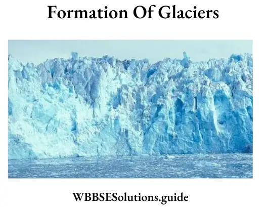
It gradually turns into ice; the first stage from snowflakes to ice crystals is called ’Neve1 or ‘firn1. These are gradually transformed into a solid mass of ice. Then under the force of its own weight, due to melting at the bottom under the influence of latent heat of the masses of ice and owing to gravitational force, the solid mass of ice starts moving and is called a glacier.
Question 16. What are the processes of aeolian erosion? Or, How does wind work in an arid region? Or, Name the processes involved in wind erosion.
Answer:
Winds cause erosion in three ways they are
1. Deflation,
2. Abrasion and
3. Attrition.
1. Deflation: The process by which the wind lifts and rolls along the loose particles on the ground is known as Deflation. It, thus, lowers the desert surfaces and causes extensive depressions.
2. Abrasion: This is the process in which the wind drives sand dust particles against an exposed rock or solid surface and results in rock surfaces being scratched, polished or worn away. This process is known as abrasions. It works most effectively near the base of rocks, where material blown by the wind is of the biggest size and the largest quantity.
3. Attrition: In this process, wind-borne particles roll against one another in a collision they wear each other away for this, their sizes are greatly reduced and .grains take rounded form.
Class 10 Geography Chapter 1 WBBSE
Question 17. What are the three types of glaciers?
Answer:
Glaciers are of three types:
1. Continental Glacier,
2. Valley Glacier or mountain glacier and
3. Piedmont Glacier.
1. Continental Glacier: Masses of ice which cover large areas of a continent are called Continental Glaciers. These are also called Ice-sheet.
Example: At present two major ice sheets are found in (1) Greenland and (2) Antarctica.
2. Valley or Mountain Glacier: The glaciers which originate and occupy mountain valleys are known as Valley Glaciers or Mountain Glaciers.
Example: The Gangotri Glacier of the Himalayas.
3. Piedmont Glacier: The word Piedmont means ‘the foot of the mountain’. The piedmont glaciers are formed by the union of the spreading ends of several mountain glaciers at the foot of the mountain.
Example: The Malaspina Glacier of southeast Alaska.
Question 18. What is sand dune?
Answer:
Sand Dune: A sand dune is a heap of sand. It is of several metres high. It moves with the prevailing winds. Sand dunes are formed by the accumulation of sand and are shaped by the movement of the wind. A sand dune is built up when the wind faces some obstruction in its paths, such as a bush, a tuff of grass or a large rock. Sand dunes are usually stationary, but they often move in the direction of the wind. However, they move very slowly. The mobile sand dunes of Rajasthan are known as Dorians.
Question 19. Into which parts can the course of a river be divided according to its work?
Answer:
The course of an ideal river, from its source to its mouth, can be divided into the following three segments (sections) according to its mode of work:
1. The upper course, or the mountain course: In this stage, the main work of a river is erosion; however, it also does the work of transportation.
2. The middle course or the course on the plains: In this course, the main work of a river is transportation however, it also does the work of deposition.
3. The lower course or the course on the delta: Near the delta, a river does the work of deposition.
Question 20. Describe the factors on which the erosive power of a river depends.
Answer:
The erosive power of a river depends upon the following factors:
1. Volume of water: It plays a vital role. A river cannot work more if the volume of water in the channel remains low. The ability increases with the rise of the volume of water. The volume of water that flows in a river is measured in a unit known as cusec or cubic metre per second.
2. Slope of the land: The ability to work of a river largely depends on it. As the slope increases, the velocity of flow increases too.
3. Load of a river: A load of a river acts as its tool. A river with a load of pebbles and stones can erode more.
4. Nature of land: The hardness of land exerts some influence on the work of a river. Soft rocks wear away easily, while hard rocks check the rate of erosion.
Question 21. What are the erosional processes of a river?
Answer: Erosion by a river is called fluvial erosion. River erosion is accomplished in the following ways, such as
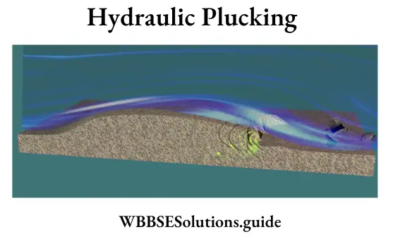
1. Hydraulic plucking: Removing and carrying the loose bedrock by the action of the force of running water is known as hydraulic plucking.
2. Abrasion or Corrasion: The wearing away of rock beds by the collision of the flowing rock fragments and the static rocks is known as abrasion or Corrosion. It is of two types:
(1) Lateral Corrasion
(2) Vertical Corrasion.
3. Attrition: The process of the formation of finer materials by the pebbles, and stones being carried by a river due to collision with each other is known as Attrition.
Corrosion: The chemical weathering of the rocks is known as corrasion or solution. Rocks like limestone dissolve in the water.
Question 22. Describe the processes of river transportation.
Answer:
The processes of river transportation
A river transports the materials that had eroded as well as a greater mass of materials brought into the river flow. A river transports its load in several ways
1. Solution: When the soluble rocks are dissolved in water they are carried in the form of the solution by the river.
2. Suspension: The fine particles of the rocks remain in a suspended position as long as the force of the upward turbulence is stronger than the downward settling tendency of the particles.
3. Saltation(Latin: Saltere means to leap): The mode of transportation of eroded particles such as small pebbles which make intermittent leaps from the river bed is called Saltation.
4. Traction: Traction is the rolling of very big rocks along the floor of the river as they are too heavy to float in the river. So they roll along the floor of the river.
Question 23. What are the processes of glacial erosion?
Answer:
Glacial Erosion consists of the following processes
1. Plucking: The pressure of the moving glacier on rocks along the mountainside pulls them and takes them away. This is called plucking.
2. Abrasion: Ice and its load move along and erode the rocks by scraping. It acts as a giant file grinding the floor and the sides.
3. Ploughing: Loose material is pushed ahead of the glacier, or rock material may fall from valley walls and come to rest on top of the ice.
Question 24. What is a snowline? Explain why its height varies.
Answer:
Snowline is the lowest limit of perpetual snow:
The height of the snowline varies with latitude, altitude, seasons and precipitation.
Latitude: It is situated at sea level in the polar regions and about 5,000 metres in the equatorial regions.
Altitude: In the Alps and the Himalayas it moves between 3,000 and 5,000 m and higher still at Mt. Kilimanjaro on the equator.
Season and precipitation: On the southern slopes of the Himalayas the height of the snowline increases from east to Weston account of a progressive decrease in moisture supply. It varies from 4,000 m in the eastern part to 5,500 m in the western part. In summer it goes up, in the wet and cold season it comes down.
Class 10 Geography WBBSE
Question 25. Distinguish between a V-shaped valley and U shaped valley.
Answer:
Difference between a V-shaped valley and U shaped valley
| V Shaped Valley | U Shaped Valley |
| 1. This valley is formed by the downcutting of the river. | 1. This valley is formed by the side cutting of glaciers. |
| 2. Deep narrow valleys and T-shaped, known as Canyons. | 2. A valley formed at a higher level is known as a hanging valley. |
| 3. This valley is formed by the cutting and down cutting of the river bed. | 3. It is formed when a glacier enters a ‘V-shaped valley. |
| 4. Its shape resembles the letter V. | 4. Its shape resembles the letter ‘U’. |
Question 26. What is a floodplain? What is the difference between a river bank and a river bluff?
Answer:
Floodplain
When there is little water in a river a lean flow silts and creates a wide and dry bed but sometimes there is so much water that a river attains a bankful stage and often surplus water spills as a flood. The valley floor over which a flood deposits silt is the floodplain. The river bed is walled by banks, the floodplains by bluffs.
Question 27. Differentiate between alluvial cone and delta.
Answer:
Difference between alluvial cone and delta
| Alluvial cone | Delta |
| 1. It is formed at a place where a river passes from arrow canyons to an open plain. | 1. It is formed at a place where the river passes from the plain to the sea. |
| 2. River doesn’t divide into distributaries. | 2. River divides into distributaries. |
| 3. It has no connection with the salt content of the river. | 3. More the salt content, the more will be the chance of its formation. |
| 4. It is formed in the middle stage of a river. | 4. It is formed in the lower stage or mouth of a river. |
| 5. It is always cone-shaped. | 5. It is mainly triangular in shape. |
Question 28. Differentiate between Yardangs and Barkhans.
Answer:
Difference between Yardangs and Barkhans
| Yardangs | Barkhans |
| 1. They are formed due to wind erosion. | 1. They are formed due to wind deposition. |
| 2. They are fixed in one position. | 2. They migrate from one place to another. |
| 3. They are roughly parallel to the wind direction. | 3. They are transverse or at right angles to the wind direction. |
| 4. They are formed of hard and soft rocks. | 4. They are formed of sand particles. |
| 5. They have flat tops. | 5. They do not have flattops. |
Question 29. Differentiate between Zeugen and Yardangs.
Answer:
Difference between Zeugen and Yardangs
| Zeugen | Yardangs |
| (1)They arc horizontal layers of harder and softer rocks. | (1)They are vertical bands of harder and softer rocks. |
| (2)They are higher in height in comparison to yardangs. | (2)They are of comparatively low height. |
| (3)It is formed due to wind abrasion. | (3)It is formed due to wind abrasion and deflation. |
| (4)It forms caves and pillar-like structures. | (4)It forms ridges and valleys-like structures. |
Question 30. Differentiate the river valley from the glaciated valley.
Answer:
Difference the river valley from the glaciated valley
| Basis | River Valley | Glaciated Valley |
| 1. Shape | V-shaped or l-shaped. | U-shaped. |
| 2. Creating an agent | Flowing water of the river. | Sliding ice of the glacier. |
| 3. Process of erosion | Corrasion as well as corrosion. | Abrasion and plucking. |
| 4. Time of predominance | Predominates in the present day. | Predominated in the past during ice ages. |
| 5. Origin and termination | Originates at the end of the glaciers and terminates at the oceans. | Originates at the high mountain slopes and terminates at the mountain bases below the snowline. |
| 6. Superimposition | Now, river valleys are superimposed on the past valleys by glaciers. | During the ice ages, glacial valleys were superimposed on the previous valleys carved out by rivers. |
Question 31. Show with the help of a diagram any two landforms developed out of glacial action.
Answer:
Landforms developed by glacial action
Class 10 Geography WBBSE
(1) Corrie and Arete: Corrie and Arete are the different types of features produced by glacial erosion. In the source regions of glaciers, in high mountain regions, glacial erosion causes a light depression to be eroded in such a way that the mountainside is steepened to form a headwall and at its foot, a pronounced depression is created by erosion.
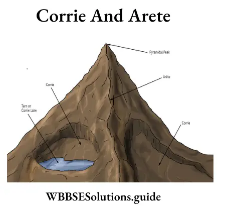
When the glacier melts away in summer these resemble an armchair-like depression called Corrie in English and Cirque in French. Whereas, Arete is formed when glacial erosion may cause adjacent Corries to develop in the mountainside. The ridge that forms the boundary between the adjacent depressions is called Arete.
Question 32. Flow is the delta formed in the old stage of a river.
Answer:
Near the mouth, at sea level, the main work of a river is the deposition of materials. Due to the heavy load of materials, the current of the river and its erosion action become weak and the accumulation of materials on the river bed is so high that the river is divided into many branches, forming islands between the two channels. This type of deposition resembles the Greek letter A and so is known as delta. Practically all the big rivers(e.g. Ganga, Nile, Mississippi, Missouri) have formed deltas. The delta of the Ganga is the largest in the world.
Class 10 Geography WBBSE
Question 33. What are the differences between a Gorge& Canyon?
Answer:
The differences between a Gorge& Canyon
1. Gorges are deep narrow valleys which look like the English letter’V’. Canyons, on the other hand, are very deep& extremely narrow, so they resemble the English alphabet T.
2. Gorges are formed due to high velocity in rivers of rainy mountain areas whereas Canyons are formed in dry regions ‘or deserts.
3. As Gorges are formed in areas receiving high rainfall, either bank gets eroded to give the shape V & many tributaries join from either bank. But canyons are mainly snowed and flow through semi-arid or dry areas.
Question 34. Differentiate between pediment and outwash plains.
Answer:
Difference between pediment and outwash plains
1. Pediment plains are produced by the work of wind, whereas outwash plains are produced by the work of glaciers.
2. Pediments are produced by wind erosion whereas outwash plains are produced by glacial deposition.
3. Pediments are slightly sloppy, dry, stony plains whereas outwash plain is covered with rocks, stones, pebbles, sand, etc. It is a levelled plain with snowmelt water flowing on the ground.
Chapter 1 Exogenic Processes And Resultant Landforms 5 Marks Questions And Answers:
Question 1. Describe with sketches three landforms carved out by glacial erosion.
Answer:
The main landforms formed by erosion by glaciers are:
1. ‘U’ Shaped valley: The valley formed due to erosion on its bed and sides is called a ‘U’ shaped valley as it resembles the English alphabet ‘U’.
2. Corrie or Cirque: In the source region of the glacier, glacial erosion causes a’ depression in the rock bed, due to which the landform looks like an armchair. It is known as corrie or cirque. When it is filled with meltwater, it forms a cirque lake.
3. Hanging valley: Often the valley of a tributary glacier meets the valley of the main glacier. As the tributary glacier forms a smaller valley than the main glacier, it looks to hang above the main valley glacier. This valley of the tributary glacier is called Hanging Valley.
Question 2. Describe with sketches three major landforms developed by the erosional work of rivers.
Answer:
The major landforms developed by the erosional work of rivers are described as follows:
1. V-shaped valley: The valley formed by a river in its upper course in which lateral erosion is greater than vertical erosion is known as a V-shaped valley as it resembles the English alphabet V. This valley is so narrow and the sides are so steep that gorges are formed.
Class 10 Geography WBBSE
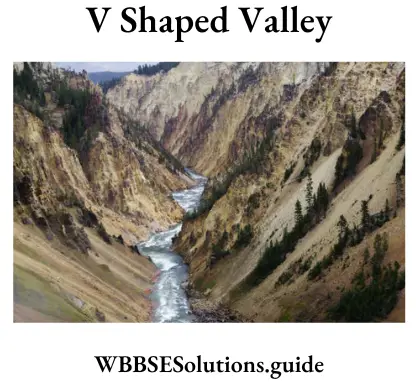
2. l-Shaped valley: The valley formed by a river in its upper course in which vertical erosion is much greater than lateral erosion is known as an l-shaped valley as it resembles the English alphabet T. This valley is very narrow and very deep. It is also called Canyon.
3. Interlocking spur: A series of spurs lies between the banks of the river. As the main channel twists from side to side, so the spurs are described as ‘interlocking’.
4. Waterfalls: When a stream plunges down a very steep slope over a cliff, it forms a waterfall. India’s highest waterfall, Jog falls, (289.08 m) is on the river Sharavati.
Question 3. Describe with sketches the major landforms produced by Flavio-glacial deposition.
Answer:
The landforms formed by glacial deposition are:
Class 10 Geography WBBSE
1. Moraines: Any landform formed by depositions of the valley and continental glaciers is called a moraine. The moraines can be mainly of three types:
(1)Moraines deposited alongside of glacial valley floor are called lateral moraines,
(2)Where two lateral moraines of adjacent glaciers combine, the deposition lying in the middle of the main glacier is called medial moraine,
(3)Moraines deposited at the end of a glacier are called terminal or end moraines.

2. Eskers: Long ridges of material deposited parallel to the direction of the flow of glacial melt water are called eskers. glacial meltwater is called eskers.
3. Erratics: These are depositions of boulders and rock fragments in an area where they are a total mismatch with the surroundings.
4. Drumlins: These are low elongated hills formed by glacial deposits. They are called ‘basket of eggs’ topography.
5. Karnes: These are small rounded hillocks of sand and gravel.
6. Outwash plains: These are materials washed out by glacial melt water and deposited in a variety of forms.
Class 10 Geography WBBSE
Question 4. Describe with sketches the landforms developed by the combined action of wind and running water in the arid region.
Answer:
The different landforms formed by the combined action of water and wind in a desert region are:
1. Wadi: In deserts, sudden torrential rains lead to the formation of valleys through which the collected rainwater may flow like a river. In the dry season, these valleys also remain dry.
2. Playa: Playas are small lakes found in deserts. They are highly saline and the water cannot be used for agricultural or household purposes.
3. Pediment: Pediment refers to the eroded and lowered plainlands that lie at the foot of the mountains.
4. Bajada: Bajada refers to the deposition of materials brought down by wind as well as water and deposited beyond the pediment.
Question 5. Describe the river’s erosional process and its different agents.
Answer:
River erosion is accomplished in many ways, such as:
1. Hydraulic Plucking,
2. Abrasion or Corrasion,
3. Attrition and
4. Corrosion.
Class 10 Geography WBBSE
1. Hydraulic Plucking: The force of moving water causes to sweep out of loose debris and particles from the river bed and channel walls, and carries the materials along in the current. These materials as carried by simple hydraulic action, range in size from clay to silt, sand, gravel and boulders.
2. Abrasion or Corrasion: Abrasion is the wearing away of the bed and banks using the load as the grinding tool. It is also called corrosion. It is the scouring action by the bedloads of rivers.
Types of Abrasion or Corrasion: The bed loads cause mechanical grinding as they knock, bounce, scrape and drag along the sides and bottom of the valley and break off additional rock fragments. The sideway erosion is called lateral corrasion. It widens the V-shaped valley. The downward erosion is called vertical corrasion. It deepens the river channel.
Potholes: Corrasion creates round holds called potholes, cylindrical holes carved into the hard bedrock of a swiftly moving stream. Potholes are deepened by spherical stones which are often found in the potholes. A spiralling flow of water in the pothole rotates the spherical stones at the base of the hole, boring gradually into the rock.
Plunge Pool: The plunge pool is another feature of the abrasion of a mountain stream. It is a deep pool cut out by the whirling round of boulders and stones at the base of a waterfall into which the water plunges.
3. Attrition: The pebbles, stones and boulders being carried by river currents do roll and collide with one another. They then transform into finer materials carried further downstream to be deposited. This attrition is the wear and tear of the transported materials themselves.
4. Corrosion: The chemical weathering of the rocks of the river bed and channel walls is called corrosion. Corrosion may be accomplished through solution and car- donation. Erosion by the dissolving action of fresh water, salt water, and acidic water is called corrosion.-The effects of corrosion are conspicuous in limestone, which develops cupped and fluted surfaces.
Class 10 Geography WBBSE
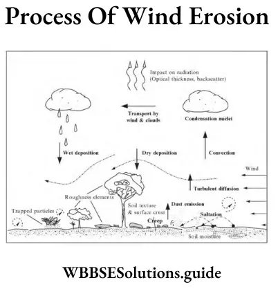
Question 6. Describe the process of wind erosion.
Answer:
The erosive power of the wind involves a triple process:
1. Deflation,
2. Abrasion and
3. Attrition.
1. Deflation: Deflation (Latin, “to blow away”) is similar to the plucking of a glacier or the hydraulic force of a river. As wind velocity increases, the surface materials lying loose are blown away. The finest ones lying loose on the surface, especially the dust, are picked up by the wind.
They are carried in suspension so long as the power of the upward currents of air exceeds the tendency of the suspended particles to fall to the ground. Generally, the wind blowing at a speed of about 16 km per hour picks up surface sand grains and transports them in suspension elsewhere.
In the suspension process, dust-like fine particles are picked up readily by the wind. Dust particles are transported to great distances and to great heights in the atmosphere. The heavier particles that are too big to be carried in suspension are bounded along the ground by the transportation process of Saltation (Latin: saltare, to leap).
Saltation makes sand grains hop, land and rebound, imparting fresh impetus to other surface particles and dislodging them. In the saltation process, the coarse sand grains are propelled by the wind. They hop, land and rebound. So sand grains are transported to short distances and maximum heights of 1.5 to 2.5 metres.
The surface particles of the ground dislodged by the saltation process are then driven forward on the ground as surface creep. In the surface creep process, small pebbles are made to roll forward with the momentum gained from jumping sand particles.
School Geography Class 10 WBBSE
Wind Load: Wind makes two types of load, such as
(1) Wind’s suspended load and
(2) Wind’s bed load. The surface particles carried in suspension by the wind make up the wind’s suspended load. The particles that bump and jump along the land surface make up the wind’s bed load. Wind load is used as cutting tools for abrasion by the wind.
2. Abrasion: The second process in which the wind erodes is abrasion. The wind-carried sand particles scratch, and polish the solid rocks. Particles carried by the wind strike obstacles such as rocks, boulders, etc. on their path. Such wind carrying a load can smooth and polish and groove rock surfaces. This activity of wind is called Abrasion (Latin ‘Scrape off).
Abrasion becomes highly forceful when the winds carry a load of hard quartz grains. After the initial weathering of rock surfaces through an excessive range of temperatures (annual and diurnal), the wind armed with rock fragments is capable to abrade. In their turn, the fragments created by abrasion are worn down by their attack which is formed like a sandblast on the solid rock against which they are blown.
Thus the process produces a great accumulation of rock debris. It is not possible for rock debris of all sizes to be transported. The pebbles and stones are not so readily removed as the fine sand. Wind can lift fine sand particles into the air and the abrasion action of the wind is the most effective within an altitude of a few metres above ground level as there is considerable frictional drag in the lowest layers of air.
In desert areas, fence posts and telephone poles are quickly cut through at the base by wind abrasion. So a protective metal sheathing or heap of large stones is placed around the base.
3. Attrition: Wind load is in a constant state of movement since it is being transported through processes like
(1) Suspension,
(2) Saltation and
(3) Surface creep.
These transportation processes involved in the gradual reduction in the size of pebbles as one rub against another are termed Attrition. More simply, attrition is the process by which different types of wind loads are reduced in size by rubbing against one another in course of their transportation by the wind.
Question 7. Describe the exogenetic processes active in producing landforms.
Answer:
The exogenetic processes active in producing landforms
Exogenetic or Exogenous or External forces are those that work on the earth’s surface from outside and result in the formation of new landforms. These forces include. the shipments of the earth’s atmosphere, other agents of denudation and the formation of the force of gravity. They are essentially processes of destruction.
Agents of exogenetic processes: Exogenetic forces include running water, ground water, sea waves and shore currents, glaciers, periglacial processes, work of wind, weathering and mass movements, etc. Man along with plants and animals also acts as an exogenetic force.
School Geography Class 10 WBBSE
Processes: Exogenetic processes work through the processes of-
(1)Weathering,
(2) Mass wasting,
(3) Erosion,
(4) Transportation and
(5) Deposition. These start as soon as a newly created landform is exposed to the influence of weather.
Classification: The exogenetic processes can be classified as follows
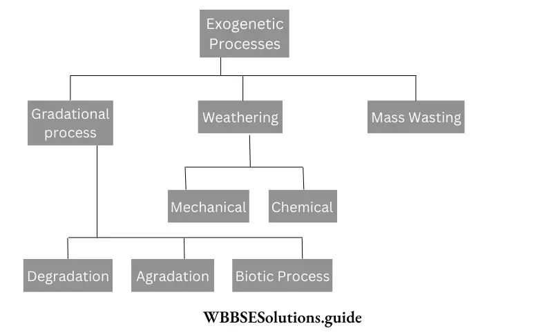
1. Gradational Process
Definition: Gradational processes are continuously engaged in removing the vertical irregularities created by endogenous processes through denudational (both weathering and erosion) and depositional activities.
Agents of Gradational Process: The important agents of the gradational process are erosional, transportation and depositional works of running water or river, glacier, wind, groundwater and works of ocean waves and shore currents.
Process: Evidently, gradation involves three different processes:
(1)The process of wearing down (erosion) uplands,
(2)The process of transporting (transportation) the eroded materials,
(3)The process of filling up (deposition) lowlands.
Hence, Gradation = Erosion + Transportation + Deposition.
Types: It is clear that gradation is achieved by simultaneous action of the following three processes
(1) Degradation,
(2) Aggradation and
(3) Biotic Processes.
Associated Landforms:
(1) Flood plains,
(2) Formation of the delta,
(3) Moraine,
(4) Formation of stalactite and stalagmite,
(5) Loess, etc. are the important landforms created by the aggradation processes.
Biotic Processes: This includes the action of animals and insects, vegetation and man.
School Geography Class 10 WBBSE
2. Weathering
Definition: Weathering is the process that breaks rocks into smaller fragments by static agents of weather. It takes place in situ which means the rock fragments are found where they were formed originally.
Types: There are two major types of weathering
(1) Physical or Mechanical weathering and
(2) Chemical weathering.
3. Mass wasting
Definition: Mass wasting is the process of movement of soil or rock mass from one region to another mainly due to gravity. It can occur slowly or gradually (e.g. soil creep, or drastically, e.g. mudflow, rock slides).
Question 8. What are the reasons behind the location of the deserts?
Answer:
The reasons behind the location of the deserts
About 1/3 rd of the world’s land is made up of deserts where the wind plays an active role in shaping the land. If you look at the world map, you will note that these deserts are more or less confined within a belt between 15° – 30° latitudes to the north and south of the equator. The reasons behind their location are:
1. These deserts lie mostly on the western part of the continents, where trade winds blow offshore and do not cause rain, e.g.: Sahara desert, Arabian desert, Iranian desert, Thar desert, etc.
2. Most of the deserts that lie in the coastal areas are influenced by the ‘desiccating effect’ of the cold ocean currents that prevent moisture to condense into precipitation. E.g.: Atacama desert (cold Peruvian current), Australian desert (West Australian current), etc.
3. In the mid-latitude temperate areas, deserts like Gobi, Takla Makan etc. lie in the continental interiors where there are extremes of temperature (continental climate). Winds lose any moisture that they may hold long before reaching the far-off continental interior.
4. The rainshadow effect produced by mountains also can create deserts. E.g.: Patagonia desert on the leeward side of Andes mountain, South America.
School Geography Class 10 WBBSE
Question 9. Suggest some measures to control desertification.
Answer:
Measures to control the expansion of the desert are:
1. Educating local poor people about the dangers of deforestation in order to stop it.
2. Employ the people to grow seedlings and transfer these too severely deforested areas during the rainy season,
3. Fixating soil by creating shelterbelts, windbreaks, etc. Windbreaks are made from trees and bushes that are planted across the path of the wind,
4. Anti-sand shields to resist the expansion of deserts to be created. Jojoba plantation is an effective anti-sand shield. This method is adopted in the Sahara desert,
5. Contour trenching, i.e., digging of trenches about 150 m long and 1 m deep to prevent water from flowing within the trenches causing erosion. Stone walls are to be created to prevent the trenches from closing up.
6. Sand fences can be used to control the drifting of soil and sand erosion,
7. Desert reclamation done by Farmer-Managed Natural Regeneration (FMNR) technique.
8. Managed intensive rational grazing for the restoration of grasslands is another method. Small paddocks with fences are to be used for grazing animals,
9. Creation of a plastic shield on the sand by sprinkling oil to prevent eroding away of sand particles,
10. Floodwater retention and infiltration and providing water for irrigation by canals dug from rivers of neighbouring regions.
(Indira Gandhi Neher in north Rajasthan provides water for irrigation in the Thar desert). Most of these measures have been adopted in the Sahara desert in Africa and the Thar desert of India for checking the expansion of the desert area.
Question 10. What are the effects of global warming on the region of Sundarbans?
Answer:
Effect of Global Warming on Sunderbans: Global warming on a large scale has affected the Sundarban region enormously. The effects of global warming are as follows:
1. Increasing temperature: The temperature of water in the Sundarbans has increased at an alarming rate of 0.5°C per decade causing harm to its aquatic life and the health of the mangrove forests. The span of the summer season has increased while that of the winter season has decreased.
2. Rising sea level due to the melting of ice sheets has led to the submergence of various islands in Sundar Moreover, the plants in the mangrove forests are becoming shorter and narrower with fewer branches resulting in lower rates of photosynthesis necessary for their regeneration.
3. Increase in the intensity and occurrence of cyclonic storms has become a serious problem. The occurrence of cyclone Aila in 2009 devastated the land.
4. Rise in the salinity due to a decrease in freshwater runoff has affected mangrove growth and soil fertility. So agriculture is also suffering from poor crop yield.
5. Due to global warming rainfall has become erratic and hence forced a change in agricultural patterns is causing low crop yield or crop failure.
6. The intrusion of saline water causes severe stress on the availability of drinking water also.
Question 11. Give an account of the current situation of Lohachara, New Moore and Ghoramara islands.
Answer:
Current situation of Lohachara Island: This island was permanently inundated in the 1980s due to a rise in the sea level probably as a result of global warming. It was an island located in the Hooghly river. It was an island located in the Hooghly river. It formed a part of the Sundarban delta before 1980. The definite disappearance of the island was reported by Indian researchers in December 2006.
It was an inhabited island with more than 6000 people. These people were forced to move to the mainland. Coastal erosion, cyclones, mangrove destruction and coastal flooding were considered as the other probable causes of its disappearance. In April 2009, however, the local Newspaper announced the re-emergence of the island from the waters.
Current situation of Newmoore or South Talpatti Island: South Talpatti (as was known in Bangladesh) or New Moore or Purbasha (India) was a small uninhabited island situated only 2 km from the mouth of Hariabhanga river in the coastal Bay of Bengal. An American satellite discovered the island in 1974. In March 2010, Sugata Flazra, an oceanographer at Jadavpur University of Kolkata, India, said that the island had disappeared due to sea level rise caused by climate change, changes in monsoon rain patterns and land subsidence.
Current situation of Ghoramara Island: Ghoramara island is located 150 km South of Kolkata, India, in the Sundarban delta complex of the Bay of Bengal. The island is only 5 sq km in area. Its existence is being threatened due to erosion and constant rise in the sea level and the total disappearance of this island in near future is apprehended.
School Geography Class 10 WBBSE
Question 12. What are the causes of desertification?
Answer:
Causes of desertification: According to Prof. Andre Goody of Oxford University, deserts extend due to various climatic and man-made causes. The gradual decrease in humidity and deterioration of land quality speeds up the process. Presently about l/6th of the total area of the world is under desert cover. The various causes of desertification are
1. Physical causes:
1)Drought: Regular and repetitive droughts in a particular area cause permanent damage to the soil. Vegetation cover is gradually lost and all ecosystems are destroyed.
2)Climatic changes: The greenhouse effect and global warming due to urbanisation, industrial growth, pollution, etc. affect the climate of the regions, which may speed up desertification.
3)Soil erosion: Removal of topsoil also causes desertification.
4)Presence of mountains: The presence of high mountains may stop moisture-laden winds to cause rainfall. Hence, deserts tend to grow in the rainshadow area.
2. Man-made causes:
1)Overgrazing: Overgrazing may remove the vegetative cover totally, causing permanent damage to the soil.
2)Over-cultivation: Over-cultivation may remove essential soil nutrients and bring about soil erosion.
3)Unscientific cultivation: Unscientific cultivation, especially in arid and semidesert areas, cause further extension of deserts.
4)Uncontrolled irrigation: Over-watering may cause some soils to become saline, hence loose fertility may tend to turn to deserts.
5)Deforestation: Cutting down trees removes the vegetative cover, causing desertification.
Question 13. Write in brief about the Sahara Desert.
Answer:
The Sahara desert:
Location: The largest hot desert of the world, the Sahara lies in Africa over about 91,00,000 sq km area. It is bounded by the Atlantic Ocean in the west, the Red sea in the east, the Mediterranean sea in the north and the Niger river valley in the south. This desert lies over the countries of Algeria, Libya, Sudan, Chad, Tunisia, Mali, Morocco, Niger, etc.
Desertification: Satellite imageries show that the area of the Sahara desert is gradually increasing, especially towards the southern boundaries.
Reasons:
1. Extreme sand storms,
2. Lack of rainfall due to global warming,
3. Reduction of agriculture at border areas of the desert,
4. Occurrence of regular droughts.
Preventive measures:
1. The Federal State and the Govt, of Nigeria together have taken up annual tree-planting programmes. Free plants are distributed to be planted in agricultural fields and personal houses,
2. Heavy reforestation programmes are taken up in dry areas of Mali, Mauritania, Niger, Senegal, Chad, Ethiopia, Sudan, etc.
3. Involvement of students, ladies and the youth in reforestation and awareness programmes,
4. Spread of knowledge and awareness by students right from school levels,
5. In India the ‘van Mahotsav programme’ was taken up, by which thousands of trees were planted along roads, railway lines and hill slopes. The ‘Green Chattisgarh programme’ included the planting of robust trees with long life expectancies like teak and tamarind and fruit trees like mango and jackfruit in the dry regions.
School Geography Class 10 WBBSE
Question 14. Write in brief about the Thar desert.
Answer:
The Thar Desert:
Location: The Thar desert spreads over 2.34 million sq km in India, covering west Rajasthan, Gujarat, southwestern Punjab and parts of Haryana.
Desertification: The region where the Thar desert lies today was known to be covered with vegetation in ancient times. The region was drained by the Saraswati and Yamuna rivers. Gradually due to geographical changes and human erratic actions the desert was created. The desert is extending still, and even the capital of Delhi may be engulfed one day.
1. High-speed winds,
2. Large moving sand dunes,
3. High diurnal range of temperature,
4. Low rainfall,
5. High rate of evaporation. The spread of gravelly soil in Jaisalmer suggests the existence of some mighty river in this region in the past. Evidence also shows that the desert extended outward in a big convex arc through Ferozepur, Patiala, and Agra towards Aligarh encroaching 130 sq km of fertile land every year.
Preventive measures:
1. Reforestation is being done on the hill slopes in this region according to several government programmes,
2. Artificial grasslands are being created to prevent the movement of sand dunes in Barmer, Jaisalmer, etc.
3. Trees that grow fast are being planted to meet the demand for fuel wood from local people in Jaisalmer, Jhunjhunu, etc.
4. The Rajasthan canal has been constructed to irrigate and reclaim infertile desert land.
Question 15. Give a brief description of three different landforms formed by the river in its lower course. Illustrate with diagrams.
Answer:
Three different landforms formed by the river in its lower course
In the lower course, near the mouth at sea level, the river loses all its strength and attains a stage of old age. At this stage, deposition becomes the main work and the river flows sluggishly; widespread deposition takes place and extensive flood plains are formed. The deposition is greater along the banks and on the mouth, and thus the following landforms are formed:
1. Flood plain: In the rainy season when a flood occurs, a widespread deposition of alluvium takes place. The depositions gradually fill up the low-lying areas of both the banks of a river and build up plains. These are known as flood plains. They are well-developed along the middle and lower course of the Ganga, Hwang Ho, Yangtze and other major rivers of the world. These flood plains are very fertile and densely populated.
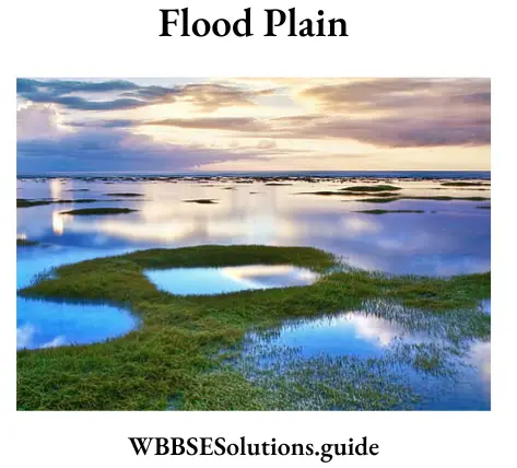
2. Natural Levees: On the lower course of a river, active deposition takes place along the banks of an old river when it is in flood. Each time this happens, the banks get higher. After a long period of such deposition, the river banks are raised. These raised banks of the river are known as Natural Levees. Sometimes, the flood water breaks through these levees and brings devastating floods. Natural levees are found along the lower courses of the great rivers, such as, the Ganga, Hwang Ho and Yangtze.
School Geography Class 10 WBBSE
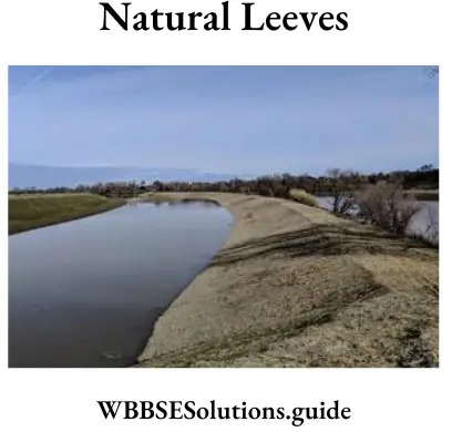
3. Deltas: Most of the load carried by a river is ultimately deposited into the sea into which it flows. The deposition, sometimes, builds up a fan-shaped alluvial cone which often looks like the Greek letter delta on its mouth and it is called delta. As deposition goes on in the river mouth, the river is forced to divide into several channels, each of which repeatedly divides.
All these channels are distributaries. Thus, a large number of distributaries are formed. The Ganga-Brahmaputra delta, the largest delta in the world, presents all these features.
Question 16. Write in short about the features mainly created by a river in its middle course.
Answer:
The main features formed by a river in its middle course are
School Geography Class 10 WBBSE
1. Alluvial fan or Alluvial cone: As the river comes suddenly from its upper course to its middle course, its velocity decreases and its sediments are deposited along with the flow of the river resembling the shape of a cone or fan. This is known as Alluvial Fan.
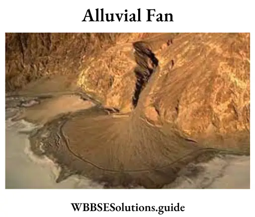
(1)Widening valley: In the middle course of a river, lateral erosion predominates. The volume of water increases and the flow of water exerts its greatest force at the banks.
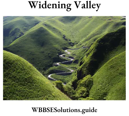
(2)Sand bars: The pebbles, sand, silt, etc. are deposited on the valley floor to form sand bars. Such bars are very common at the mouth of a river.
(3)Meander: In the middle course of river a because of the slackening of speed, a series of loops and bends are noticed. These bends are called meanders.
2. Oxbow lakes: During the meandering course of a river it often cuts through the curve to flow straight. Hence the left curve becomes a lake called ox-bow lake or horse-shoelace.
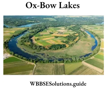
3. Flood plains and Natural levees: During the rainy season flood occurs in the river. So the water spreads out and deposits the sediment brought down and forms flood plains. On the bank of the river repeated deposit of silt or clay increases the height of the bank, forming natural levees.
4. Yazoo streams: During floods, levees may develop across the junctions of minor tributaries. Those tributaries are then compelled to follow a meandering course of their own until they find a new entrance in the main river. They flow roughly parallel to the main river in between the levees. Such rivers are called yazoos.
School Geography Class 10 WBBSE
Question 17. Describe the main erosional landforms formed by glaciers.
Answer:
The main landforms formed by glaciers are
(1) ’U’ Shaped valley: The valley formed due to erosion on its bed and sides is called a ‘U’ shaped valley as it resembles the English alphabet ‘U’.

(2)Corrie or Cirque: In the source region of the glacier, glacial erosion causes a depression on the rock bed due to which it looks like an armchair. It is known as corrie or cirque. When it is filled with melt-water, it forms a cirque lake.
(3)Arete: Knife-edge ridge that is developed when the walls of two back-to-back corries have met after sapping from both sides, is called Arete or Serrated Ridge.
(4)Pyramidal Peak: Several aretes may meet at one point to make a peak known as Pyramidal Peak.
(5)Col: A col is a notch or a pass from where two cirques intersect to produce a deep saddle between high peaks.
(6)Hanging valley: Often the valley of a tributary glacier meets the valley of the main glacier. As the tributary glacier forms a smaller valley than the main glacier, it looks to hang above the main valley glacier. This valley of the tributary glacier is called Hanging Valley.
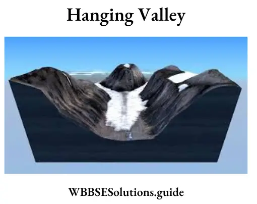
(7)Roche Moutonnee: These are hillocks of rock of a glaciated mountain which have been smoothened by the glacier on the upstream side, and left rough and rugged, with steeper slopes on the downstream side. They resemble sheep lying on the hillside and are also called sheep rocks.
(8)Crag and Tail: Along the path of a glacier if hard rocks and soft rocks lie one after another, the hard rocks protect the soft rocks from erosion by the glacier, so the hard rocks form a steep slope of a mountain called crag, while the soft rocks gently slope downwards to form a tail. This is called Crag and tail.
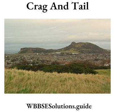
Question 18. Describe the aeolian depositional landforms with examples.
Answer:
The aeolian depositional landforms
Depositional work of wind is geomorphological very important because significant features like sand dunes and loess are formed. Deposition of wind-blown sediments occurs due to a marked reduction in wind speed and obstruction caused by Pushes, forests, marshes and swamps, lakes, big rivers, walls, etc.
School Geography Class 10 WBBSE
Sand dunes are heaps or mounds of sand. There is a wide range of variations in the shape, size and structure of different types of dunes. They also vary in height and length. Dunes are classified on various bases-named morphology, structure, orientation, location etc.
1. Barkhans: Barkhan is a crescent or moon-shaped sand dune formed in a perpendicular direction to the wind. The windward side is convex and gentle while the leeward side is concave and steep. Its ends are called Horns. These resemble a Sickel or Bow. The sand dunes keep on advancing and many towns and vi buildings have been buried under these sand dunes.
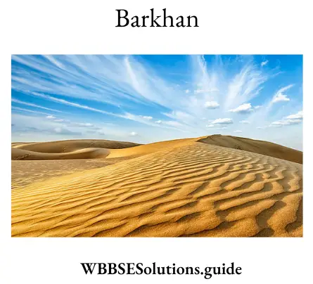
2. Longitudinal dunes: These are long narrow ridges of sand. These lie parallel to the direction of the prevailing wind. They are sometimes hundreds of metres high. These are called Sief (meaning sword) in Sahara.
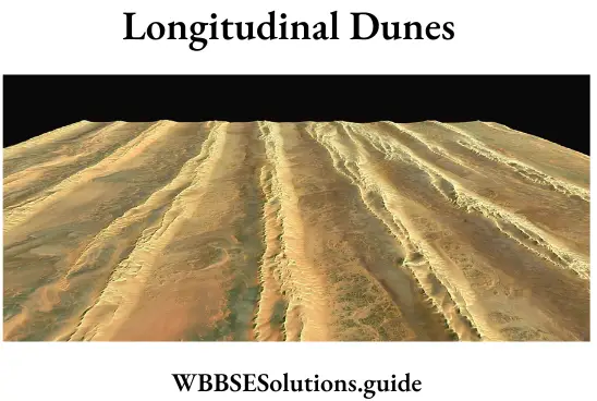
3. Transverse dunes: These are formed perpendicular to the wind. They look like large waves of sand. They are semicircular in shape.
4. Star dunes: The dunes having multiple slip faces, high central peaks, and radially extending three or more arms are called star dunes. Unlike other dunes, star dunes grow vertically and thus do not migrate laterally.
5. Whaleback dunes: The dunes formed of coarser sands left behind due to the migration of longitudinal dunes are called whaleback dunes. Very large whaleback dunes are called ‘dress’.
6. Head dune and Tail dune: Sometimes when there is an obstruction like a rock along the path of blowing wind, a sand dune gradually forms adjacent to the rock or the windward side, named a head dune. Another dune which forms on the leeward side is called a tail dune. The dune that forms just a little before the head dune is called an advanced dune and the dunes formed on both sides of the obstruction is called lateral dunes.
7. Loess: Loess is a wind-borne deposit. It is a yellow, porous, fertile deposit. The most extensive deposits are found in the N.W. China in Hwang-Ho Basin. It covers an area of 3 lakh sq. miles. Actually, the word ‘loess’ comes from such a deposit in a village of France.
Question 19. Compare the works of a river with those of a glacier.
Answer:
| River | Glacier |
| 1. Rivers arc the running water, rainwater or snow-melt water moving downwards along the slope of the land. | 1. Glaciers are moving ice slowly come down because of the pull of gravity. |
| 2. The rivers move faster than the glaciers and their erosive power is much more than that of glaciers. | 2. The glaciers move slowly and their erosive power is less than that of the rivers. |
| 3. Obstruction causes the river to form a meander. | 3. Obstruction causes the glacier to remove or move over it. |
| 4. The work of a river depends on the slope of the land, rock character and volume of water | 4. The work of a glacier mainly depends on the volume of the glacier and the character of the rock over which it flows. |
| 5. River valleys are V-shaped. | 5. Glacier valleys are ‘U’- shaped. |
| 6. The materials formed as a result of erosion due to river flow are rounded and smooth. | 6. Materials formed due to glacial flow have no definite shape. |
| 7. The course of a river can be divided into three stages: upper, middle and lower courses. | 7. The course or path of a glacier can not be divided in such a manner. |
| 8. The materials carried by a river are deposited according to the shape and size of the materials along the various stages of the river. | 8. The materials transported by a glacier are deposited at any part of its valley and in various sizes. |
| 9. Erosion by a river generally occurs through physical and chemical actions. | 9. Glaciers only erode by physical action. |
| 10. River erosion produces gorges, waterfalls, rapids, cataracts, potholes, V-shaped valleys, alluvial fans, etc. | 10. Glacial erosion produces features like ‘U’- shaped valleys; corries or cirques, aretes, pyramidal peaks, hanging valleys, etc |
| 11. River deposition produces flood plains, levees, deltas, braided channels, meanders, oxbow lakes, etc. | 11. Glacial deposition produces moraines (lateral, medial, frontal), kames, drumlins, eskars, outwash plains, etc. |
| 12. River action can be seen in all areas of the world except very cold and dry desert regions. | 12. Glacier action can only be seen in the high mountains and in the very cold polar regions of the world. |
Question 20. Describe the landforms formed due to aeolian erosion.
Answer:
The landforms formed due to aeolian erosion
1. Mushroom Rocks Sometimes the degree of hardness in the rocks varies considerably. Due to differential abrasion, the softer rock is worn out more easily than the harder rock and the under-cutting on the base is more than on the top forming narrow rock. The rock resembles the like of an elephant or camel or another animal. Local names are given to this type of rock such as Mushroom rock or Gour.
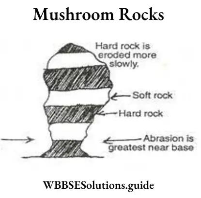
2. Zeugen When the wind blows steadily in one direction for a considerable time due to differential abrasion, the wind wears away the underlying softer rock through the joints (caused by mechanical weathering). The harder rock layer stands uneroded and stands like ridges. This is known as Zeugen. They are of varying heights (from 1.5 m to 45 m).
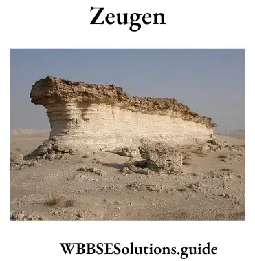
3. Yardangs: Yardangs are one of the various landform features developed out of aeolian erosion in desert regions. When hard and soft rocks are arranged vertically on the earth’s surface, then the soft rocks get quickly eroded forming long valleys while the hard rocks stand out as ridges called Yardangs. These are generally 15 metres high and are found in the deserts of Central Asia.
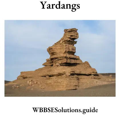
Sometimes hard and soft rocks stand parallel to the prevailing winds. Due to abrasion soft rocks are worn away and the hard one stands as stony ribs. The whole area resembles ‘furrow’ or ‘ridges’. This phenomenon is known as ‘Yardang’. This is common in the Atacama desert.
4. Inselberg: Inselbergs are very highly resistant hard rock structures formed due to wind erosion. They are found in desert areas and are of usually the same height. They have a flat-topped surface with steep slopes.