
Chapter 2 Unstable Earth
Unstable Earth:
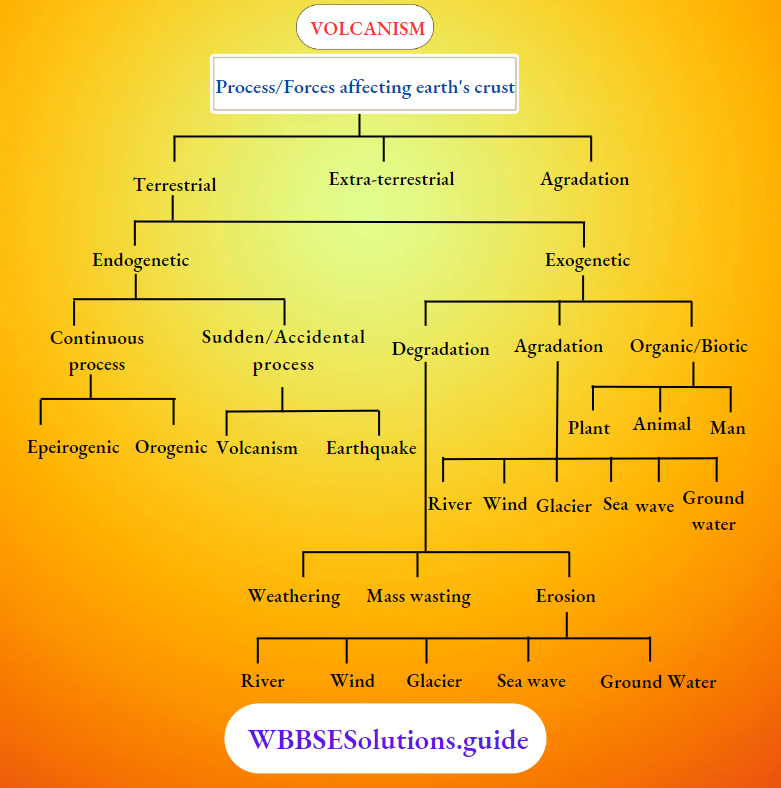
- Though the Earth apparently seems stable, it does not follow that it is fully stable. The earth’s crust has been undergoing changes for millions of years. The earth is unstable because it is regularly facing natural events like violent volcanic eruptions, earthquake tremors, shifting of plates, landslides, avalanches etc.
- Though we cannot always feel this movement of the land on the surface of the earth, but the face of the earth is constantly shaped by these natural forces active above the surface of the earth and beneath it.
Read and Learn all WBBSE Notes For 8 Class Middle School Geography
- According to the ‘Continental Drift Theory’ of Alfred Wegner—about 300 million years ago, all the present-day continents of the world were united as an aggregated supercontinent called ‘Pangaea’, during the Carboniferous period.
- Later on, it began to break apart and the pieces drifted in two directions, e.g., (1) equatorward movement and (2) Westward movement. Actually, the continental crust (Sial) was floating over the oceanic crust (Sima). But this theory could not fully explain the causes of earthquakes or the formation of most of the continents, oceans, mountains and volcanism etc.
- In the 1960s, an elegant and exciting theory emerged that provided an elegant unifying explanation for all geological processes past and present. This theory is called ‘Plate Tectonics’ and it is a great scientific achievement of the decade of 1960s.
“WBBSE Class 8 Geography Chapter 2 notes, Unstable Earth”
Definition of the plates and Plate-tectonics: The rigid lithospheric slabs or rigid and solid crustal layers are called ‘Plates’. The whole mechanism of the evolution, nature and motion of Plates and resultant reactions is called ‘Plate Tectonics’, in other words, the whole process of plate motions is referred to as ‘Plate Tectonics’.
| Class 8 General Science | Class 8 Maths |
| Class 8 History | Class 8 Science LAQs |
| Class 8 Geography | Class 8 Science SAQs |
| Class 8 Maths | Class 8 Geography |
| Class 8 History MCQs | Class 8 History |
It may be mentioned that the term ‘Plate’ was first used by Canadian geophysicist J. T. Wilson in 1965. Makenzie and Parker discussed in detail the mechanism of plate motion in 1967. W. J. Morgan and Le Pichon elaborated on the various aspects of Plate Tectonics in 1968. Now Continental Drift and displacement are considered a reality on the basis of Plate Tectonics.
The theory of Plate Tectonics comprises only four basic concepts:
- The outer portion of the earth—its crust and uppermost segment of the mantle (i.e., lithosphere) is composed of large rigid units called Plates.
- The plates move in response to the flow of the heat-softened ‘asthenosphere’ beneath them.
- Most of the World’s large-scale geological activity, such as volcanic eruptions, and earthquakes, occurs at near plate boundaries.
- The interiors of plates are relatively quiet geologically, with far fewer and milder earthquakes than occur at plate boundaries and little volcanic activity.
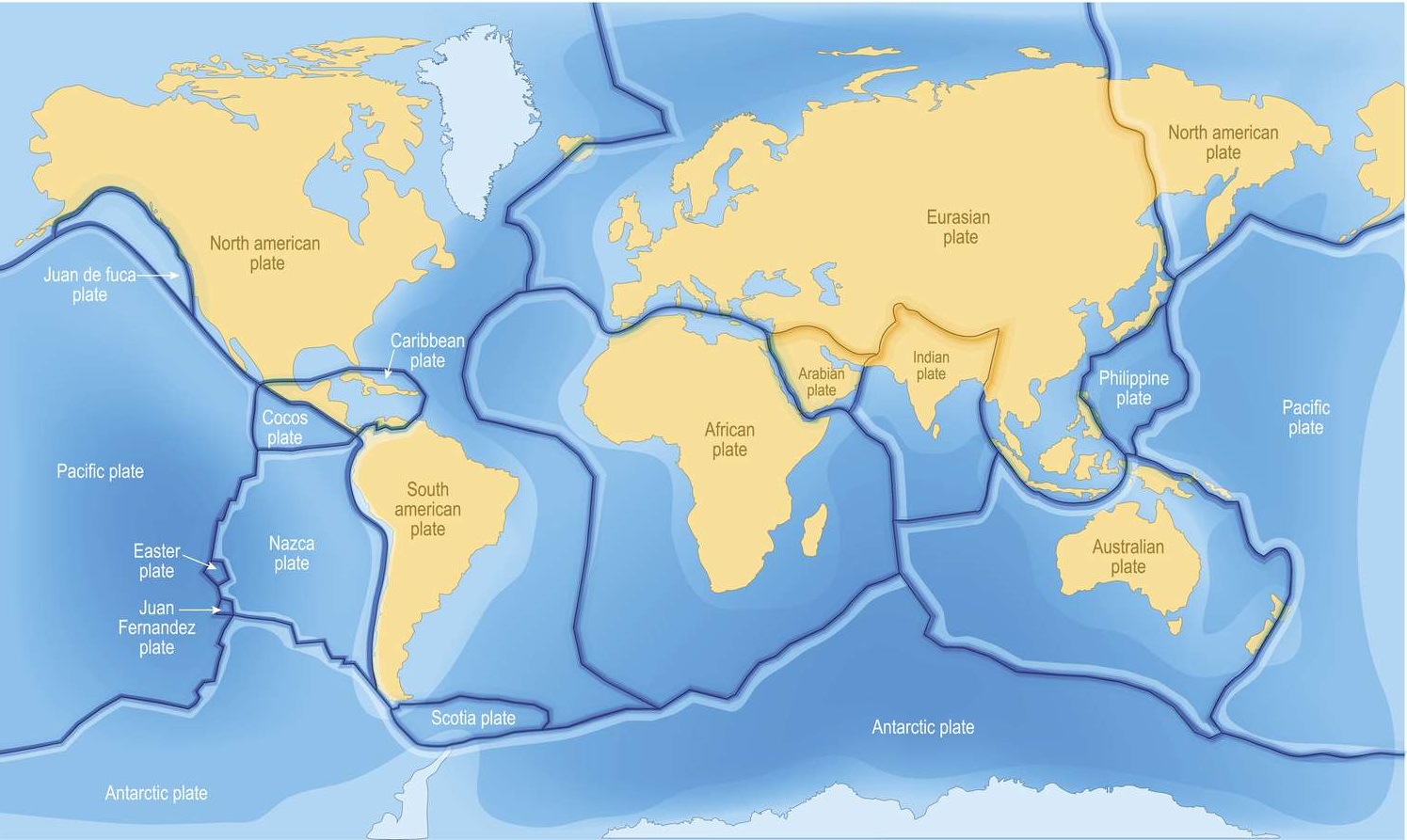
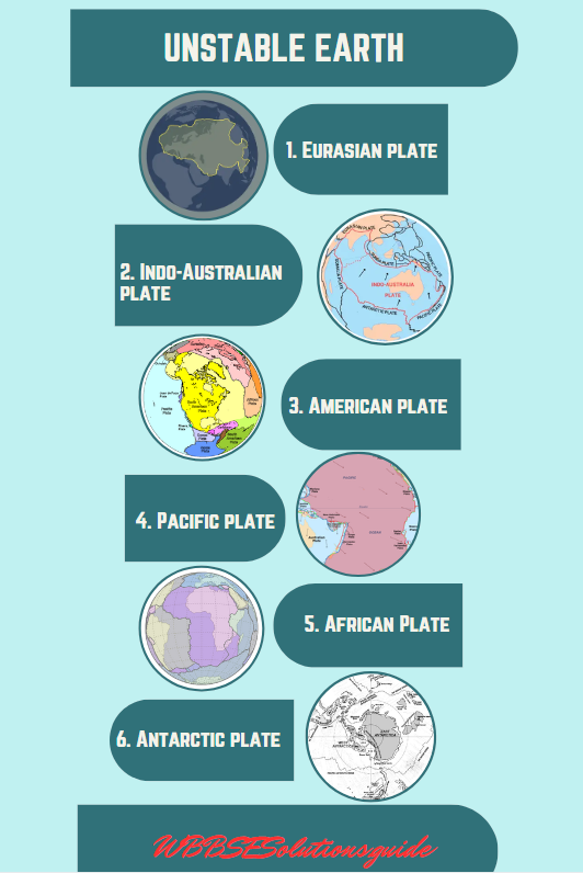
There are six large (major) and twenty small (minor) plates. The six major plates are the
- Eurasian plate,
- Indo-Australian plate,
- American plate,
- Pacific plate,
- African Plate and
- Antarctic plate.
Movements of the Plate and Geological History: The earth’s plates move relative to each other in several ways, and plate boundaries are categorized according to which type of movement they demonstrate. Here instead of a whole continent portion of the ocean is also attached to the plate. Here the North American continent plate moves westward away from Europe along with the western half of the Atlantic ocean.
“Class 8 WBBSE Geography Chapter 2 notes, Unstable Earth study material”
There are three major types of boundaries:
- Divergent or constructive plate boundary, where plates move apart,
- Convergent or destructive plate boundary, where p|ates move together, and
- Neutral or transform plate boundary, where plates move past one another in opposite directions.
- Divergent or constructive plate boundary: When two plates diverge or follow different directions, the narrow space between the two is called a ‘rift’. The magma then fills this space. The such a plate boundary is called ‘divergent’ or ‘constructive plate boundary’.
- Throughout the period of divergence, ocean basins continue to expand as molten rock erupts, creating new oceanic lithosphere that builds up to form the mid-ocean ridge. The process of plate growth at the mid-ocean ridge is known as ‘sea-floor spreading’. Japan and its adjacent islands along the western coast of the Pacific Ocean have been formed in this way.
- Convergent or destructive plate boundary: When two plates converge or move towards the same point, they may either collide against each other or push the third plate with their combined force. The boundary of such plates is also called a ‘convergent or destructive ‘ plate boundary. The Himalayas were formed in this way from the sediments of the Tethys sea between the European and Indian plates.
- Neutral or Transform plate boundary: Where two plates slide past or grind past one another along transform faults and thus crust is neither created nor destroyed, this is known as ‘Neutral or transform plate boundary’.Such is the case with San Francisco and Los Angeles, which are located within the San Andreas transform zone between the North American and Pacific plates.
“WBBSE Class 8 Geography Chapter 2, Unstable Earth study guide”
Chapter 2 Unstable Earth Earth Volcanism
Volcanism: The process responsible for the upward movements of molten rock or magma through the Earth’s crust is called ‘volcanism’.
Volcano: The word ‘Volcano’ is derived from the greek term ‘Vulcan’ meaning the god of the underground.
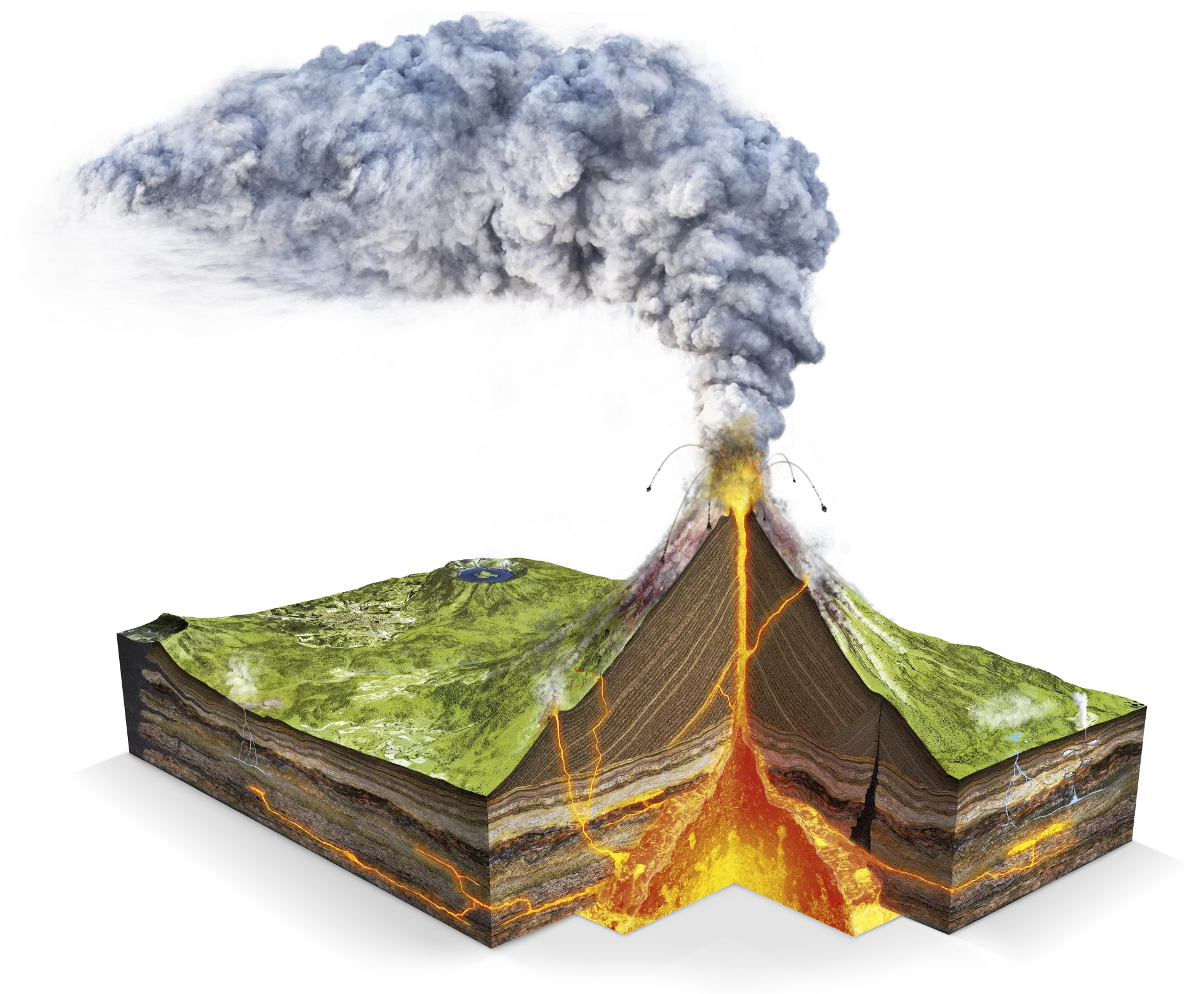
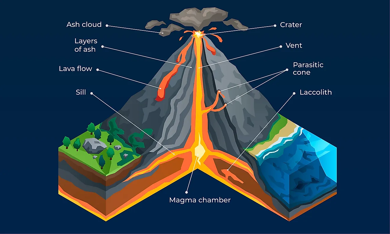
A volcano is a vent or opening in the Earth’s crust through which magma and other materials erupt from the interior of the earth. Volcanoes usually consist of a conical hill or mountain formed from molten rock or lava, ashes and rock fragments ejected through the volcanic vent.
Parts of a Volcano:
- Vent—The vent is the hole through which the volcanic materials come out.
- Volcanic Pipe—Volcanic pipe is the narrow opening which connects the vent with the interior.
- Crater—Crater is the funnel-shaped hollow at the core of the volcano.
Different types of volcanic eruptions: When solid, liquid and gaseous materials are thrown out of the interior of the earth, it is known as a ‘volcanic eruption’. There are two main modes of eruption-
- Central Eruption and
- Fissure Eruption:
- Central Eruption: When lava erupts through a vent, violent explosion takes place. It results in the formation of the volcanic cone; such as Vesuvius and Fujiyama. A crater is formed at the summit. Most of the volcanoes are of cone and crater type. A chain of such volcanoes forms a volcanic mountain range.
- Fissure Eruption: When there is a quiet upwelling of lava through fissures over a large area, it is known as a ‘fissure eruption’. It gives rise to extensive lava plains or plateaus. The Decan Trap of Peninsular India is an example of this type. It covers an area of 5 lahks sq. km with a thickness of lava sheets exceeding 1000 metres. Fissure eruption has taken place in Ireland and Iceland also.
Classifications of Volcanoes: Based on the frequency and nature of eruptions volcanoes are classified into three major types. These are as follows :
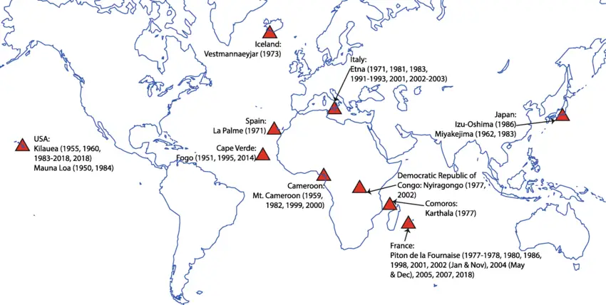
- Active volcanoes: The volcanoes that erupt frequently or are always emitting lava are called ‘active volcanoes’. Mouna Loa in Hawaiian islands is the largest active volcano of the world, other important active volcanoes are the ‘Vesuvius’ of Italy, ‘The Stromboli’ of Lipari island, ‘Etna’ of Sicily, ‘Erebus’ of Antarctica and ‘Barren’ island of India.
Active Volcanoes are of two types: (1) Incessant and (2) Intermittent volcanoes.
- The volcano that erupts incessantly is known as an ‘incessant volcano’, e.g. Mt. Erebus of Antarctica,
- The volcano that emits with intervals, is known as an ‘intermittent volcano’, e.g. Vesuvius of Italy.
2. Dormant Volcanoes: Dormant volcanoes are also called sleeping volcanoes’. These volcanoes have been active in the past and have stopped ejecting lave now, but can erupt again in any time, e.g. Mt Fujiyama of Japan.
“WBBSE Class 8 Unstable Earth notes, Geography Chapter 2”
3. Extinct Volcanoes: The volcanoes which have never erupted in human history are’ called ‘extinct’ or ‘dead volcanoes’, e.g. Mt. Kilimanjaro in Africa, Mt. Popa in Myanmar, Mt. Cotopaxi in Ecuador.
‘Aa’: A type of dense, viscous volcanic lava with a rough blocky structure is known as ‘Aa’, in the Hawaiian language.
‘Pa hoe hoe’: A type of highly fluid lava that spread out in sheets over vast areas from the volcanoes of the Hawaiian island is called ‘Pa hoe hoe’ in the Hawaiian language. The upper surface of this type of lava cools very quickly and looks like a twisted rope.
The constructive Effects of volcanoes:
- volcanic eruptions increase the fertility of the soil.
- The water of hot springs, Geysers is considered very useful for people.
- The volcanoes result in the formation of precious stones, minerals, such as diamonds are due to volcanic eruptions.
- The volcanoes provide us with crater lakes and depressions caused by the volcanoes.
Disadvantages of volcanoes:
- Volcanoes are highly destructive.
- They cause much loss of life and property.
- Many towns are buried under Lava.
- Crops are destroyed in large areas.
- Eruptions in the sea kill millions of fish.
- In the 1883 Krakatoa eruption 36000 persons were killed due to high tidal waves.
- Volcanic ash pollutes the atmosphere.
- Many poisonous gases kill animals in some areas.
Earthquake: Earthquakes are sudden, rapid and detectable vibrations, tremors or shaking caused in the earth’s crust by tectonic movements or volcanic eruptions.
Chapter 2 Unstable Earth: Causes Of Earthquakes
Major causes of Earthquakes: Earthquakes occur frequently in unstable portions (subduction zones) of the earth’s crust. The two major endogenetic causes of earthquakes are volcanic eruptions and tectonic forces.
Minor causes of earth tremors include landslides or avalanches. Artificial or man—induced earthquakes or anthropogenic earthquakes are caused by human activities. So, there are two types of earthquakes, i.e. Natural earthquakes, and Artificial (anthropogenic) earthquakes.
Natural causes of Earthquakes:
1. The tectonic earthquakes are caused due to:
- The dislocation of rock blocks during faulting activity,
- Drifting of the continents and plates of the earth,
- Mountain building movements (orogenic process) etc.
2. Volcanic earthquakes are caused due to:
- Volcanic eruptions or explosions of the volcanoes and
- Movements of molten rock (magma/lava) below, or within the crust.
3. Isostatic earthquakes are caused due to imbalance in the geological processes generally, the earthquakes of active zones of mountain building are included in this category.
4. Plutonic earthquakes occur at greater depths when heat is radiated from the earth’s interior the earth’s crust may contract giving rise to earthquakes.
5. Heavy rainfall in mountain regions often causes landslides that may cause earthquakes.
6. Avalanches in high mountain regions may also cause earthquakes.
“Class 8 WBBSE Geography Chapter 2, Unstable Earth easy explanation”
Artificial or Anthropogenic (Man-induced) Earthquakes: Besides the natural causes of earthquakes, human activity also causes artificial earthquakes. These anthropogenic earthquakes are caused by the pumping of water and mineral oil reserves from underground aquifers and oil reserves respectively, deep underground mining, blasting of rocks by dynamites for constructional purposes (e.g. for the construction of roads, dams, reservoirs etc.), nuclear explosion, storage of huge volume of water in big reservoirs (Koyna earthquake in Maharashtra, India of 1967 due to Koyna reservoir) etc.
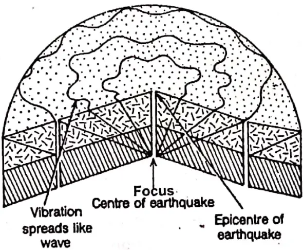
Focus or Centre of the Earthquake: The place of origin of an earthquake inside the earth is called the ‘centre’ or ‘focus of the earthquake’. Observations have shown that most of the centre or focus of the earthquakes lie within 16 kilometres from the surface of the earth.
It may be at a depth from 50 to 100 km and only a single earthquake occurs at still greater depths. The shock waves travel in all directions from the focus.
1. Epicentre: The point on the earth’s surface just vertically above the centre or focus of the earthquake which experiences the greatest intensity is called ‘Epicentre’. Being nearest, the intensity of vibration is maximum at the epicentre.
So, an earthquake is the strongest and most destructive near the epicentre. Also, it is worth remembering that the effects of an earthquake are felt on a much wider area if its focus lies deep below the earth’s surface.
Speed of the earthquake waves: On the earth’s surface the speed of earthquake waves varies between 5 to 8 km per second, with the speed increasing inside the earth’s crust.
“WBBSE Class 8 Geography Chapter 2 notes, Unstable Earth PDF”
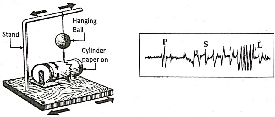
Seismic waves and their types: A shock wave generated by an earthquake is called a seismic wave’. Seismic waves are of three basic types: P-wave, S-wave and L-wave. The study of the waves is also important for understanding how earthquakes cause destruction to things in their path.
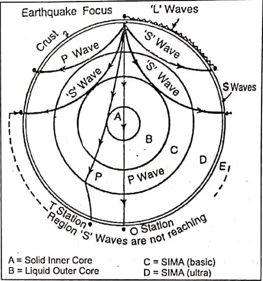
- Primary wave or Push waves (P-wave): This is the fastest seismic wave (6 to 8 km/ Sec.) and reaches the earth’s surface before point of happening or focus by the displacement of surrounding particles. They are transmitted through solids, liquids and gases.
- Secondary waves or Shake waves (S-wave): They travel through solids only under the crust. It reaches the earth’s surface immediately after the Primary (P) wave (3-5 km/Sec) The speed of secondary (S) waves is about 3/5 as fast as primary waves.
- Surface waves/Long Waves(L- waves): They travel on earth’s surface. L (surface)-waves travel at around 3 km/sec. The waves cause vibrations inside the earth. These waves spread out from the epicentre of the earthquake. These waves are responsible for most of the damage caused by earthquakes.
“WBBSE Class 8 Geography Chapter 2, Unstable Earth important questions”
Measurement of Earthquakes: Earthquakes are studied by a special subject known as ‘seismology’ or the science of earthquakes (from the greek word ‘seismic’ meaning earthquakes). That is why the instrument recording the shock waves is called the ‘Seismograph’.
This instrument helps in determining the source of the earthquake, the movements of the earthquake, waves etc. The function of a seismograph is to measure the intensity of the earthquake shocks. It can record and calculate the distance of vibrations thousands of kilometres away including the focus and the epicentre.
Seismogram: During an earthquake, the oscillation of the marker of a seismograph marks the paper to create a graph is called a ‘seismogram’.
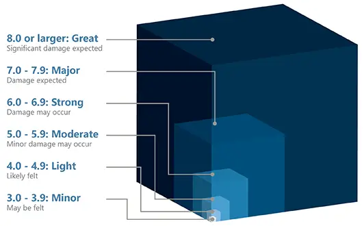
Richter Scale: The intensity or severity of an earthquake is measured with reference to a scale called the ‘Richter Scale’. Prof.Charles F. Richter of California University created this scale, in 1935, which is named after him. This scale is placed on the seismograph.
It is a logarithmic scale and uses a system of rating. This scale ranges from 0 to 9, but in practice, there is no upper limit. Every increase or one number of magnitude means the motion is 10 times greater. Earthquakes of 7 and above intensity of the Richter scale are highly destructive.
Modified Mercalli Scale: The effect of an earthquake at a given spot is measured using an intensity scale—the Modified Mercalli Scale. The intensity varies with distance from the epicentre. It uses subjective analysis like the type of rock, earth, dwelling units etc. The scale has 12 divisions or degrees ranging from low to high intensity.
“Class 8 Geography Unstable Earth notes, WBBSE syllabus”
Earthquake Prone Regions of the World: Earthquakes are more common along fault lines running through the weakness zones of the earth. Earthquakes can also take place where there is a Hot Spot on a plate.
Convergent, divergent and transform (neutral) plate margins have earthquakes occurring along them. But earthquakes are frequent along the convergent plate margins because there is more intensity. Earthquakes occur in almost every part of the world, but they are frequent in the following well-defined belts.
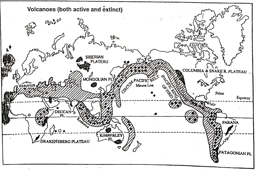
- The Circum-Pacific Belt: About 68% of all earthquakes are observed in the vast region of the Pacific Ocean as ‘the Pacific Ring of Fire’ or ‘Fiery Ring of the Pacific’ or ‘Fiery Girdle of the Pacific’. It is closely linked with the region of crustal dislocations and volcanic phenomena. Chile, California, Alaska, Japan, Phillippines, New Zealand and the Mid-ocean areas have many minors and major earthquakes in this belt.
- The Mid-World Mountain Belt: About ZlS^qarthquakes of the world originate in this belt. It extends along the fold mountains of Europe and Asia. It runs through the Alps, the Caucasus and the Himalayas. This belt has folded mountains, large depressions and active volcanoes.
- Other Areas: The remaining 11% of earthquakes of the world originate in other areas such as the Mid-Atlantic, Rift valley of East Africa, Central Siberia, Red Sea and the Dead Sea zone.
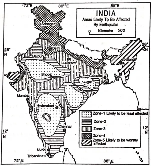
Earthquake-prone Regions of India: Our country India is an earthquake-prone land. About .two-third of this country is prone to earthquakes. On the basis of vulnerability to earthquakes, India can be divided into five seismic zones.
The earthquakes in India are at present mainly confined to the Himalayan region and its foothills. They are also felt in the Ganges-Brahmaputra Valley.
“WBBSE Class 8 Chapter 2 Geography, Unstable Earth solutions”
But the earthquakes in the Koyna Dam region in 1968 and Latur in 1993 in the Deccan Tableland (Plateau) came as surprise because it was considered a earthquake-free region.
Scientists believe that while in the former case reservoir caused cracks in the rocks, in the latter case the movement of the Indian Plate might have been the cause.
Effects of Earthquakes: The change brought by earthquakes on the surface of the earth:
- The earthquakes sometimes cause landslides and give to rise to the formation of block mountains and rift valleys.
- The earthquake block the flow of rivers and causes lake formation.
- The earthquakes sometimes changed the courses of rivers due to landslides causing severe floods.
- Depression-causing lakes are formed.
- Many springs and waterfalls are formed.
- They can cause vertical and lateral displacement of parts of the crust and raise or lowering of parts of the sea floor.
Destructive Effects:
- There is loss of life and property due to violent earthquakes.
- Fractures and cracks are formed, and railway lines are twisted.
- The earthquake causes tsunamis or tidal waves which destroy houses, buildings and also the life of man and animals.
- Dislocate electric wire and cause a fire.
- The earthquakes cause landslides and disturb the isostatic equilibrium.
- Many towns are destroyed. The communication system is disturbed due to the destruction of roads, bridges etc.
Constructive Effects: Earthquakes have some advantages also—
- Sometimes earthquakes cause the emergence of the coast and bring fertile shores out of the water to give a chance to develop crop production.
- The rift valleys are converted into lakes which become a source of water.
- Sometimes earthquakes cause the formation of hot springs which are very useful to people.
- Many minerals, gems and precious stones come out of the interior of the earth.
- Bays are formed along the coast to provide new harbours.
- Earthquakes provide knowledge about the interior of the earth.
- Sometimes the earthquake waves help in the formation of fold mountains which are very good from a climatic point of view.
- The earthquakes sometimes cause submergence in coastal lands and result in the formation of inlets, bays, and gulfs which make the site favourable for the development of fishing and shipping etc.
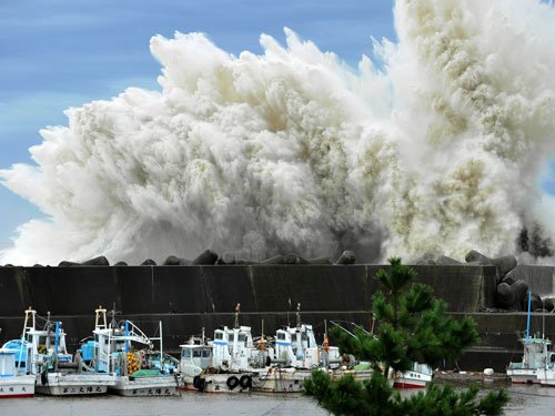
Tsunami: Tsunami is a Japanese word, that means waves of harbour’ (Tsu = harbour, nami – Wave) or, it also means ferocious oceanic quake’ (Tsu = ferocious, ‘na’ = oceanic; mi = quake). It is known as destructive sea waves.
“WBBSE Geography Class 8 Unstable Earth, Chapter 2 key concepts”
When a severe earthquake takes place below the ocean bed, its tremors give rise to huge wall-like sea waves rushing to the coastal areas. These sea waves are often as high as 27 metres, and as long as 160 kilometres travelling at a jet speed of 800 km/hour. Quite common along the coast of Japan and certain regions of the Pacific Ocean, Tsunamis can be more destructive.
About 3 lakh lives were lost and enormous damage was caused over eleven countries in Southeast Asia, including India, by a tsunami resulting from an earthquake of 8-9 magnitude under the Indian Ocean on 26th December 2004.
Prevention of Earthquake: Forecast and Essential Planning—Man is unable to prevent earthquakes, all he can do is to take steps for safety. Though earthquakes can not be predicted, but some preventive measures and planning can save many lives.
Sometimes our own observations, like sudden changes in atmospheric conditions and abnormal behaviour of animals, can help us to forecast the arrival of an earthquake. The suitable earthquake-proof building structures need to be encouraged. Disaster management infrastructures are also needed.
“WBBSE Class 8 Geography Chapter 2, Unstable Earth summary”
Disaster Management:
- Identifying the risk factors in a building.
- Planning to fight hazards.
- To keep essential materials to the case of an emergency handy.
- To repair the weak and dilapidated parts of a house.
- To take shelter under stout furniture during an earthquake.
- Appraising the injuries and damages when the tremors stop.
- Disaster management and executing the pre-planned steps.
What to do when an earthquake occurs:
- Come out of the house or school building quickly and stay in the open field.
- Quickly go under a table.
- Close the door and windows and stay indoors.
- Pack essentials before leaving the house.
- Disconnect electricity.
WBBSE Notes For 8 Class Middle School Geography
- Chapter 1 Interior Of The Earth Notes
- Chapter 3 Rocks Notes
- Chapter 4 Pressure Belts And Winds Notes
- Chapter 5 Cloud And Rain Notes
- Chapter 6 Climatic Regions Notes
- Chapter 7 Human Activities And Environmental Degradation Notes
- Chapter 8 Some Neighbouring Countries Of India Notes
- Chapter 9 North America Notes
- Chapter 10 South America Notes
- Chapter 11 Oceania Notes